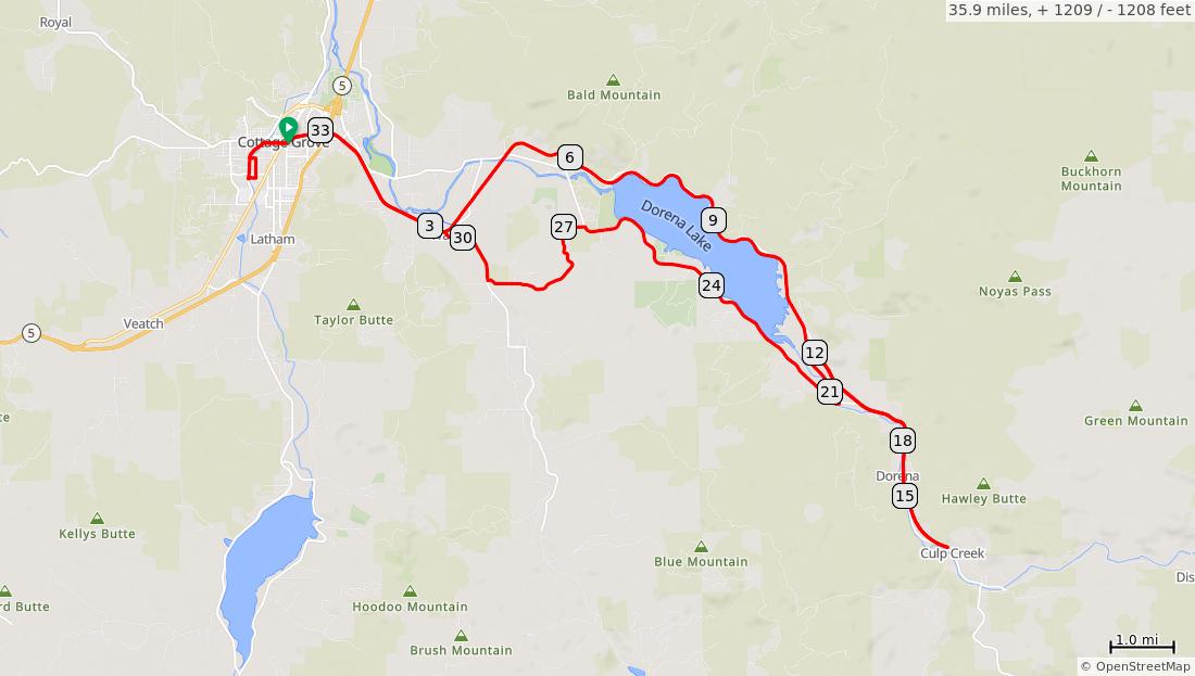
Covered Bridges Scenic Bikeway
Num Dist Prev Type Note Next 1. 0.0 0.0 Start of route 3.2 2. 3.2 3.2 Continu e on Row River Trail Mosby Creek Trailhead - water, restroom s 0.6 3.2 miles. +85/-44 feet Num Dist Prev Type Note Next 3. 3.8 0.6 Continu e across Layng Rd on Row River Trail Use extreme caution crossing road. 0.9 0.6 miles. +0/-0 feet Num Dist Prev Type Note Next 4. 4.8 0.9 Continu e through tunnel on Row River Trail Use the new tunnel to avoid "at grade" crossing of Row River Rd 1.5 0.9 miles. +0/-0 feet Num Dist Prev Type Note Next 5. 6.2 1.5 Continu e across Row River Rd on Row River Trail Use extreme caution crossing the road. Motorize d traffic is fast and coming from blind turns and warning lights do not always operate properly 2.6 1.5 miles. +0/-0 feet
Num Dist Prev Type Note Next 6. 8.8 2.6 Continu e on Row River Trail Harms Park - pit toilets 3.1
+0/-0
Num Dist Prev Type Note Next 7. 11.9 3.1 Continu e across Row River Rd on Row River Trail Use extreme caution crossing the road. Motorize d traffic is fast and coming from blind turns. 4.2
2.6 miles.
feet
+0/-0
Num Dist Prev Type Note Next 8. 16.1 4.2 Around at end of paved Row River Trail Restroom s and parking at end of path. 2 miles on Row River Rd to Wildwood Falls 1.3 4.2 miles. +0/-0 feet Num Dist Prev Type Note Next 9. 17.4 1.3 Continu e on Row River Trail Dorena just off route on the leftfood, water 2.8 10. 20.2 2.8 L on Row River Rd Informati on kiosk on the opposite side of the intersecti on. 0.2 4.1 miles. +55/-94 feet
3.1 miles.
feet
Num Dist Prev Type Note Next 11. 20.4 0.2 Continu e on Row River Rd Bake Stewart Park on rightrestroom s 0.8 12. 21.2 0.8 Sharp R on Shorevi ew Dr 0.0 13. 21.2 0.0 Continu e on Shoreli ne Dr Dorena Covered Bridge to the left 3.5 1.0 miles. +2/-11 feet Num Dist Prev Type Note Next 14. 24.7 3.5 Continu e on Shoreli ne Dr Baker Bay County Parkrestroom s, water, camping 2.0 15. 26.7 2.0 L on Garoutt e Rd Begin climbing hill with 8% grade and sharp corners. 2.5 5.4 miles. +51/-157 feet Num Dist Prev Type Note Next 16. 29.1 2.5 Continu e on Garoutt e Rd Stewart Covered Bridge on right 0.0 17. 29.2 0.0 R on Mosby Creek Rd Use caution: narrow shoulder 1.1 18. 30.3 1.1 R on Jenkins Rd 0.1 3.6 miles. +17/-24 feet Num Dist Prev Type Note Next 19. 30.4 0.1 L on Row River Trail after crossin g Lang Rd Mosby Creek Trailhead - water, restroom s 3.2 20. 33.6 3.2 R on Main St Historic Downtow n Commerc ial District 0.4 3.3 miles. +44/-85 feet
Num Dist Prev Type Note Next 21. 34.0 0.4 L on River Rd Centenni al Covered Bridge and Applegat e Trail Interpreti ve panels on right 0.7 22. 34.6 0.7 L at crossw alk onto ramp to Chamb ers Bridge 0.0 1.0 miles. +1/-0 feet Num Dist Prev Type Note Next 23. 34.7 0.0 Continu e through Chamb ers Bridge and park Chamber s Bridge is an historic railroad bridge that has been restored. Interpreti ve panels in bridge and in Covered Railroad Bridge Park 0.1 24. 34.8 0.1 L on 1st St 0.3 0.1 miles. +1/-0 feet Num Dist Prev Type Note Next 25. 35.1 0.3 L on Madiso n Ave 0.1 26. 35.2 0.1 Continu e across Swing Bridge 0.0 27. 35.2 0.0 R on River Rd 0.4 28. 35.5 0.4 R on Main St 0.4 29. 35.9 0.4 End of route 0.0 1.1 miles. +3/-2 feet


