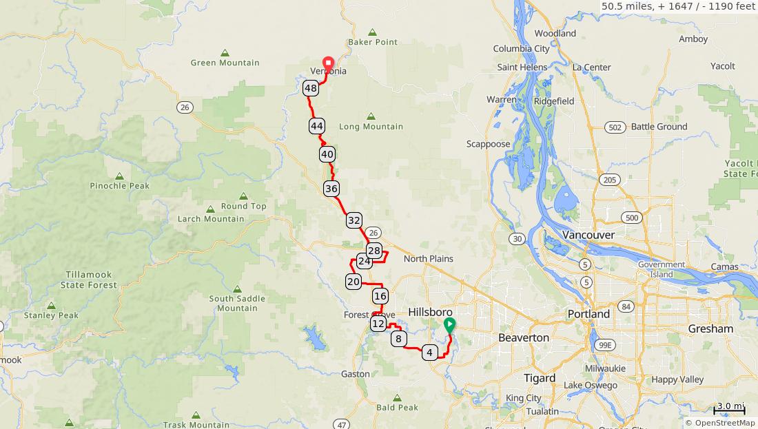
Tualatin Valley Scenic Bikeway
Num Dist Prev Type Note Next 1. 0.0 0.0 Start of route 2.7 2. 2.7 2.7 R on Burkhal ter Rd 1.2 3. 3.9 1.2 L to continu e on Burkhal ter Rd 0.4 4. 4.2 0.4 Continu e across OR-219 onto Simpso n Rd Exercise caution crossing the highway 0.5 4.2 miles. +151/-150 feet Num Dist Prev Type Note Next 5. 4.7 0.5 Bear R on Johnso n School Rd 2.9 6. 7.6 2.9 L on Tongue Ln 0.4 7. 8.0 0.4 R on Golf Course Rd 2.0 8. 10.0 2.0 L on Lafollett Rd 0.8 9. 10.8 0.8 R on Geiger Rd 0.9 10. 11.8 0.9 R on Fern Hill Rd 0.6 7.6 miles. +117/-146 feet Num Dist Prev Type Note Next 11. 12.4 0.6 Continu e on Fern Hill Road Fernhillwater, restroom s, nature trails (no bicycles on trails) 0.2 12. 12.5 0.2 Continu e across OR-47 onto Maple St Exercise caution crossing the highway 0.3 0.7 miles. +2/-0 feet Num Dist Prev Type Note Next 13. 12.9 0.3 L on 18th Ave 0.1 14. 13.0 0.1 Continu e on 18th Ave Joseph Gale Parkwater, restroom s 0.4 15. 13.4 0.4 R on Elm St 0.2 16. 13.6 0.2 Continu e on Elm St Forest Groverestauran ts, stores, water, restroom s 0.1 1.1 miles. +17/-4 feet
Num Dist Prev Type Note Next 17. 13.7 0.1 R on 21st Ave 0.2 18. 13.9 0.2 L on Hawtho rne St 0.1 19. 14.0 0.1 R on 22nd Ave 0.5 20. 14.5 0.5 L on Oak St 0.4 21. 14.9 0.4 Continu e across OR-47 onto Porter Rd 1.5 22. 16.4 1.5 R on Verboor t Rd 0.1 2.8 miles. +42/-31 feet Num Dist Prev Type Note Next 23. 16.5 0.1 L on Visitatio n Rd 0.9 24. 17.4 0.9 L on Osterm an Rd 0.9 25. 18.2 0.9 Continu e across OR-47 onto Kemper Rd Exercise caution crossing the highway 1.8 26. 20.0 1.8 R on Kansas City Rd 2.5 3.6 miles. +43/-61 feet Num Dist Prev Type Note Next 27. 22.5 2.5 R on Greenvi lle Rd 3.3 28. 25.8 3.3 L on Roy Rd 1.0 29. 26.8 1.0 L on Mountai ndale Rd 0.8 30. 27.6 0.8 Bear R on Wilkesb oro Rd 1.1 31. 28.7 1.1 R on OR-47 Caution: Heavy traffic 0.7 8.7 miles. +123/-138 feet Num Dist Prev Type Note Next 32. 29.4 0.7 Continu e on OR-47 Banksstores, restauran ts 0.3 33. 29.7 0.3 R on Banks Rd 0.0 34. 29.8 0.0 L on BanksVernoni a State Trail 0.0 1.0 miles. +1/-6 feet
3.9 miles. +47/-19 feet
6.1 miles. +460/-72 feet
Num Dist Prev Type Note Next 35. 29.8 0.0 Continu e on BanksVernoni a State Trail Banks Trailheadrestroom s, water, parking 3.8 36. 33.6 3.8 Continu e on BanksVernoni a State Trail Manning Trailhead - parking 2.9
Num Dist Prev Type Note Next 37. 36.5 2.9 Continu e on BanksVernoni a State Trail Buxton Trailhead - parking, restroom s 3.2 38. 39.7 3.2 Continu e on BanksVernoni a State Trail Stubb Steward State Parkcamping, restroom s, water 2.1
Num Dist Prev Type Note Next 39. 41.8 2.1 Continu e on BanksVernoni a State Trail Caution: Steep downhill 0.3 40. 42.1 0.3 Continu e on BanksVernoni a State Trail Top Hill Trailhead - parking, restroom s 0.1 2.3
feet Num Dist Prev Type Note Next 41. 42.2 0.1 Continu e on BanksVernoni a State Trail End of steep climb 4.1 42. 46.3 4.1 Continu e on BanksVernoni a State Trail Beaver Creek Trailhead - parking, restroom s 4.2 43. 50.5 4.2 End of route 0.0 8.5 miles. +132/-392 feet
miles. +0/-77


