
13 minute read
BUSINESS


A Trio of Adventures from BackRoadsWest.com
By Cliff & Ilene Bandringa I n keeping with the Outdoor Adventure theme of this issue of ViewOn Magazine, we would like to introduce ourselves and our style of travel writing to you. We are a husband and wife team who write travel logs, but with a twist. The twist is that, with each travel log article, we create not only the written version you are about to read here but also a more detailed version of it on our website/blog which includes pictures and our exclusive interactive map. We also provide a unique “virtual video tour” that can be viewed on YouTube that virtually takes you on the trip(s) you are reading about. Each travel log is a type of trip - a hike, a road trip or a place. Today, we’ll be taking you on all three types of trips and have included links to both our blog and the videos. Snow Canyon State Park near St. George offers a variety of colorful rock formations and the White Rocks Amphitheater is part of that collection. Many people think of southern Utah as the home of red rocks (which it is) so don’t let the name White Rocks keep you away. What it may lack in color, it makes up for in texture, elegance, and beauty. This area has some of the finest examples of petrified sand dunes and angular cross-bedding in southern Utah. It is impressive!
Advertisement
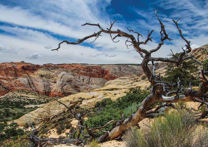
White Rocks Amphitheater in Snow Canyon hike to

The White Rocks Amphitheater is found in the northern section of Snow Canyon. It is easy to find from the pavement and easy to access on foot. The amphitheater itself is reached following a well-marked hiking trail about a half-mile long. Once you’ve had your fill of the swirling sandstone of White Rocks Amphitheater, another short trail takes you to a sprawling overlook of Snow Canyon itself. Here you will be able to see examples of both white and red Navajo Sandstone. If you hike to both the amphitheater and the overlook, the round-trip total distance is about 1.6 miles on mostly level ground. Get to the White Rocks Amphitheater trailhead by first getting yourself to St. George via I-15, Exit at Bluff Street (Hwy 18) and head north for 11.5 miles. Look for the northern entrance to Snow Canyon State Park on your left and drive into the entrance station to pay your fee. Turn around when it is safe to do so, go back to Hwy 18, and turn left. Just a half-mile past the entrance, the parking area for the trailhead will be on your left. Park here.
From the parking area, the trail heads west towards the white sandstone. You can make out the amphitheater’s

entrance in the distance – watch our virtual video tour for a clue. In just over a quarter mile, a trail junction is reached. Turn right to continue to the amphitheater. You will return to this junction later and continue to the left (heading south now) to the overlook of Snow Canyon.
After the junction, in less than a quarter of a mile, you’ll reach the entrance to the amphitheater. The trail ends with a sign pointing to the left and up to White Rocks Amphitheater. From here on, you must navigate your own way over a sea of swirling sandstone. But don’t worry about losing your way because the path is fairly obvious.
From the trail’s end, you will climb a short, steep segment of sandstone. After the climb, look ahead and you will realize why it’s called an amphitheater. You first walk through a somewhat narrow entrance with the swirling sandstone on both sides of you. Walking further, the amphitheater opens up into a very large bowl.
You might feel compelled to climb the sandstone walls on the south side of the amphitheater. Since the sandstone is porous, hiking shoes will grip it very well and aid your ascent. Climbing the sandstone is an interesting experience. If you climb all the way to the top, you will certainly have an outstanding view.

Once you’re done with the amphitheater, retrace your steps all the way back to that trail junction. Here, go right, which is south, and walk another third of a mile to the overlook that gives a great view into the top section of Snow Canyon and the expansive red and white Navajo Sandstone that shapes the canyon. At this overlook area are some more beautiful swirling sandstone formations.
The overlook is the end of our hike so, once again, retrace your steps back to the trail junction, turn right, and return to the trailhead. While walking back, notice in front of you how the black volcanic basalt rock that spewed out of the cinder cone just up Hwy 18 from the trailhead is in sharp contrast with the white sandstone. This contrast in rock colors is what Snow Canyon is famous for.

Take the hike without leaving your chair by watching the virtual video tour on our travel blog at www.BackRoadsWest.com/blog. Search for “White Rocks”, then scroll down to watch the video. Or, open YouTube on your favorite viewing device and search for “White Rocks Amphitheater in Snow Canyon”.
Grand Gulch Mine Road Trip to the on the Arizona Strip
In the middle of the Grand Canyon Parashant National Monument sits the remains of the Grand Gulch Mine. This copper/silver/lead mine is a great destination for anyone who wants to experience the adventure of traveling through the remote landscapes of the Arizona Strip. Along the way, you’ll see some of the high country of the Strip, pass through rugged Pigeon Canyon, then drive through some high-desert plains before reaching the Grand Gulch Mine.

97 May/June 2020 | VIEW ON MAGAZINE | Getting to the Grand Gulch Mine is quite a drive and requires a high-clearance, 4WD vehicle. It is about 160 miles round trip on dirt roads. We have always done this as a day trip but, if you’re a camper (which we are not), planning a severalday camping trip to this area is a great way to go. From your campsite at one of the designated spots within the Monument, you’ll have closer access to other remote sights in the area like Snap Point, Twin Point Overlook (see our
blog post on this trip), Toroweap, Mt. Trumbull and Whitmore Canyon and you won’t have to make the long journey back to civilization each night for food and lodging.
The Grand Gulch was discovered in 1874, by a member of the Shivwits band of Paiute Native Americans who found a vein of high-grade copper that was 50% pure. He told the residents of St. George about his find and soon after, several people ventured out to the remote region and started a mining operation. By 1878, an adobe stone smelter was built but was never used. Ironically, the chimney still stands today as one of the mine’s more prominent features.

round trip for pack trains hauling ore took about a week. Then from St. George, the ore was hauled by wagon all the way to the railroad in Milford, Utah - almost 200 miles away from the mine! From there, it was shipped to Salt Lake City for smelting. Rising shipping costs caused the mine to close in 1882. Try to imagine how difficult it must have been back then as you travel to the mine today in your modern vehicle with an engine and rubber tires!

In 1899, the mine was purchased by a new entity and work began at the site again including the sinking of a 500 foot-deep shaft. In 1905, hauling expenses were reduced thanks to a 73-mile long road that was constructed to a railhead near the town of Moapa, Nevada. Then later, in 1912, the haul road was reduced to 45 miles when a rail line was completed to the town of St. Thomas (that now sits at the bottom of Lake Mead).

Teams of up to 10 horses were used to haul 8 to 12 tons of ore at a time. The road squeezed through a very narrow and twisty canyon where the teamsters used specially trained horses to get through the tight turns. Today, this route makes a great hike in Gold Butte National Monument. These were successful years for the Grand Gulch. They lasted until 1919, when the demand for copper after World War I decreased and the ore began to run out. Learn more details about the mine’s history and production on our blog including a detailed 60 page account of the mine.

Start your journey to the Grand Gulch Mine by first stopping at the BLM office on Riverside Drive in St. George. Check road and other conditions with the staff here first before setting out into the remote expanses of the Arizona Strip. The road conditions can, at times, be easy-going, but other times are impassable. Because of the remoteness of the area, be prepared with food, water and other backcountry supplies and we also recommend that you travel with at least one other vehicle. There is NO cell phone service.

Take I-15 to Southern Parkway and exit at River Road. Turn right and the pavement quickly turns to dirt as you cross the Arizona State line. Reset your odometer, then continue on this road for 38.3 miles and turn right onto road 103. Stay on 103 and when your trip odometer hits 63.9, look for and turn right onto road 1002. Shortly after this turn, road 1002 dips down into Pigeon Canyon and here is where the road may become rough. When driving through here, be sure to look up at the canyon walls to enjoy the rock formations. They are one of the highlights of this trip.
After driving just over 78 miles on dirt from the Utah border, the Grand Gulch Mine is finally reached and two antique dump trucks greet you at the end of the road. Although much of the mining equipment has been removed and sold for scrap and many of the buildings have deteriorated, there is quite a bit left to see. Next to the two trucks is the ruins of a brick building built in 1900, that served as the mine’s headquarters. Across the road from this building is the adobe smelter chimney which sits in the area where the mining took place. Behind the chimney are many mounds from multiple digs plus a few structures beyond that. Continuing a short distance down the road, you will see the old bunkhouse built in 1907. A road bearing left goes to an airstrip built during the 1955 phase and is popular with pilots who can fly in and explore the site.

Learn more and see what the trip looks like by watching the virtual video tour found on our blog (search for “Grand Gulch”). Or search for “Grand Gulch Mine in the Arizona Strip” on YouTube.
Rochester Panel Rock Art Site

In central Utah there are several superb Native American rock art sites and the Rochester Panel is probably one of the most spectacular. While most rock art sites have a smattering of petroglyphs or pictographs, the Rochester Panel is a large concentration of petroglyphs of many different designs. You will leave the site wondering what they all mean.
This trip actually takes you to two different rock art sites and both sites are remote. In fact, they are just north of the most remote segment of interstate highway in the U.S. which is I-70 between Salina and Green River, Utah. But don’t worry, not far from the two sites and 20 miles north of I-70 is the very small town of Emery. And the Rochester Panel can actually be found quite easily by typing “Rochester Rock Art” into Google Maps. If you are coming from Nevada or southwest Utah, plan your trip by spending a night or two in one of the nearby towns, such as Ferron or Castle Dale (each have hotels) along Hwy 10, or even Richfield along I-70. That way, you can include more interesting stops, such as the Fremont Indian State Park along I-70 and the Museum of the San Rafael in Castle Dale. These two additional stops will round out your Native American Rock Art adventure experience.
| VIEW ON MAGAZINE | May/June 2020102 What makes the Rochester Panel so unique is that there are drawing styles found here from several cultures that existed for the past 10,000 years. Those cultures include (from oldest to newest) the Archaic, which created the famed “Barrier Canyon Style” rock art around Utah, the well-known group called Anasazi, now known as the Ancestral Puebloan people, and the Fremont People. Both the Anasazi and Fremont existed together from around 100 to 1600 AD. However, at the Rochester Panel, archaeologists are sure that most of the art created here were done by the Fremont People.
With that said, studies of the Rochester Panel done in the 1980s, concluded that the panel represents a type of calendar observatory. After much conjecture and testing, they discovered that if a pole was placed at a specific spot in front of the panel, it would cast a shadow on specific petroglyphs marking certain events, such as the summer solstice, the equinox and other annual events. The museum in Castle Dale showcases more information about the Rochester Panel and other nearby Native American sites.
A visit to the Rochester Panel will certainly make you stand back in awe and leave you wondering what it all means. When you’re finished contemplating, drive another 11 miles to visit the Molen Reef petroglyph site, which is also known as Dry Wash Petroglyphs. It’s not quite as spectacular as the previous stop but it does have some unique designs including a big snake. Just a hundred feet northeast of the parking area (in the opposite direction of the petroglyphs), don’t miss the dinosaur trackway.
When it comes to who created the petroglyphs,it’s a very complicated subject. One thing that most historians, rock art experts, anthropologists and current day Native Americans will agree on is that they don’t know the meaning of most rock art. We may never know exactly who did what, but for us, it’s enough to know that they were created a long time ago by the people who lived there and we enjoy the thought-provoking nature of them. It’s good to still have a little bit of wonder in the world. And, if you’d like to learn more about any of these subjects, there is plenty of research material out there. Then you can form your own opinions about what they are trying to say.
While driving to the Rochester Panel on I-70, you’ll pass right by the rather large grounds of the Fremont Indian State Park. Learn more about the Fremont culture and see all the rock art they left behind here by taking exit 17 off I-70, which is located 17 miles east of I-70’s intersection with I-15. Our blog post on the Rochester Panel has more information including driving directions. Dial in our website at www.BackRoadsWest.com/blog, then type “Rochester” into the Search box. Or, find our video on YouTube by searching for “Rochester Panel Rock Art Site in Utah”.
Visit our blog and/or YouTube channel to browse through the many other trips.
Happy Exploring! V


