5 minute read
TRAVEL


A Visit to
Gold Butte National Monument
Advertisement
By Cliff & Ilene Bandringa, BackRoadsWest.com
Ready to go on an overland adventure that is seemingly far, far away, yet close to home? Nevada’s newest National Monument, Gold Butte, offers many wide-open desert scenery, colorful and uniquely shaped rock formations, dozens of archeological sites, and miles of back roads to enjoy. Who knew that all of this and more is just 20-40 miles south of Mesquite?
Sandwiched between Lake Mead NRA, Grand Canyon National Park, and Grand Canyon-Parashant National Monument, Gold Butte preserves a unique corner of the Mojave Desert. Similar to the Mojave National Preserve 100 miles to its southwest, Gold Butte sets aside pristine desert scenery for future generations.
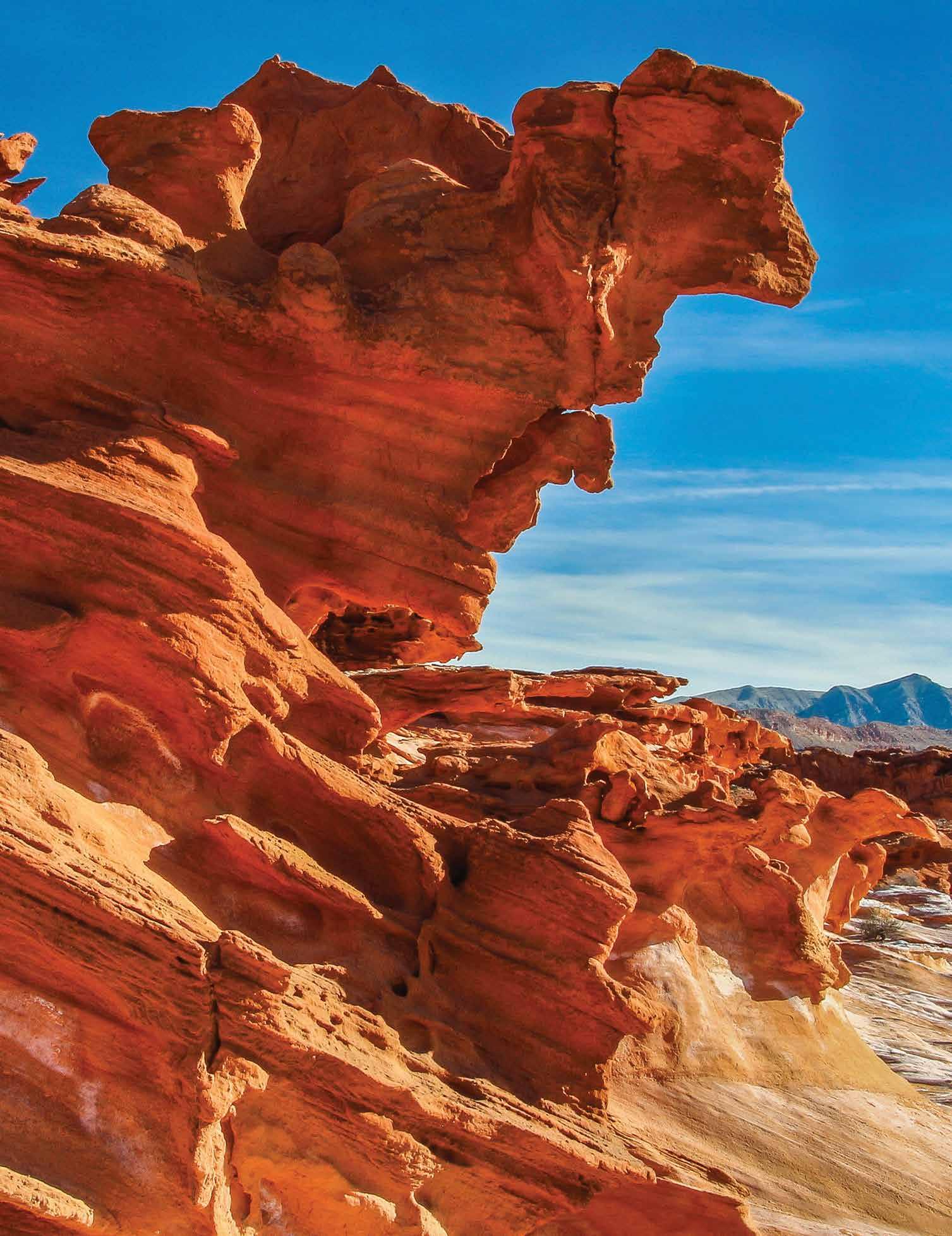
Along with its classic Mojave Desert scenery, Gold Butte is also known for its abundance of Native American rock art, including the well-known Falling Man petroglyph. Another popular attraction in Gold Butte is a unique area of intricate geological formations called Little Finland. There’s also a ghost town where a short-lived mining boom took place at the beginning of the 20th century.
Today, we’re going to take you on an 88-mile round trip loop tour through the Monument, but first, here’s some general information you should know before you go.
If you are reading this in the month of May, it could already be too hot to visit, and it is definitely too hot to visit between June and mid-September. The best times to explore and enjoy the Monument are from October until early May. And, if you visit in March or April, you might see some dazzling wildflower displays.
Keep in mind that Gold Butte is a very remote area with little to no cell phone service. Be prepared with water, food, fuel, and common sense. Regular cars can handle the road’s paved portion, but we don’t recommend that you attempt any of the dirt roads. Stock trucks and SUVs can normally handle those roads, but, like any desert dirt road, they are subject to change over time or after a significant weather event. Most 4WD vehicles and ATVs with all-terrain tires can tackle these issues. Still, you might want to consider going to Gold Butte with another vehicle or more for safety.
OK, let’s start our tour! This trip provides you with a good overview of the Monument but, for more details and to see our virtual video tours, go to our blog at www.BackRoadsWest.com/blog and search for “Gold Butte”.
We start by taking exit 112 (Hwy 170) off I-15 and going south for a few miles. Just after crossing the Virgin River, turn right onto Gold Butte Road and reset your odometer. The badly aging pavement of this road stretches for 21 miles and is full of potholes, so be careful.


This loop route is called the Gold Butte National Backcountry Byway, and there are signs throughout the Monument. And, on a map, it’s shaped like a great big lollipop with the handle being the paved section and the approximately 50-mile round dirt portion being the lollipop.
For the first few miles, you’ll pass by ranchland paralleling the river. At 12.5 miles, you’ll cross the National Monument boundary. A few miles past that, look to the right of Lake Mead in the far distance as the road crosses a very large alluvial slope called a bajada. Here is your best bet to see wildflowers in the spring.

At 19.7 miles, a dirt road goes off to the right and leads to the Monument’s largest collection of rock art and a maze of colorful rock formations. You can easily spend a whole day here and still not see everything.
Back on Gold Butte Road, continue for another 1.5 miles to reach Whitney Pocket, where the pavement ends. In this area are more colorful rock formations, an ATV staging area with restrooms, places to camp, and a historical dam built in the 1930s by the CCC (Civilian Conservation Corps). Down the main dirt road, about 3.5 miles past Whitney Pocket, we turn right onto Mud Wash North Road. This road takes us down into a fun, twisting desert wash, and in a few miles, we pass by vividly orange sandstone outcroppings where there are more petroglyphs.
A few more miles down the road, and we’re near Little Finland, which is not visible from the road. This is another place where you can easily spend all day exploring and looking at these other-worldly rock formations.


Continuing down the road another 5 miles, we arrive at Red Bluff Spring. Here, you can go on a 2-mile round trip hike through a small desert oasis and then into a narrow canyon.
Gold Butte’s Backcountry Byway now heads due south and passes through a more remote portion of the Monument. In 14.5 miles, we’ve reached the townsite of Gold Butte. Like many ghost towns, there’s not much left here except for a few foundations, some dilapidated mining equipment, and two gravesites.

From here, head north on the same Byway, and in 20 miles, we complete the loop and are back at Whitney Pocket. Then, it’s another 20 miles back to civilization on the so-called “paved” road. To learn more, visit: FriendsOfGoldButte.org. They support the Monument and have a visitor center in Mesquite. Their handy map is invaluable when visiting the Monument.
Happy Exploring!V
Read more about Gold Butte or take a virtual tour by going to BackRoadsWest.com/blog or search for “Gold Butte: How to Visit” on YouTube.


