7 minute read
Navigation


Restrictions on Routes
Speed limits should be observed for the purpose of traffic management and avoidance of shallow areas. Maximum speed limit and minimum safe distance from oil field installations should be strictly observed in the following areas: • When passing close to oil field installation to minimise wake wash • When passing in shallow waters to avoid grounding • Safe speed regulations under COLREGs to be adhere with • Speed limit regulations from port authorities when passing through port limit or using crossing a navigational channel • When passing in development areas or underwater survey is in progress • VTIS instructions with regards to speed limit should always be followed • No entry in oil fields restricted areas and minimum safe distance passing by oil field installations to be maintained • Information regarding these restricted zones are clearly marked on navigational charts


Traffic Control and VTIS
Vessel Traffic and Information System (VTIS) Procedure for Ships
• All vessels with in VTIS coverage area either under Abu Dhabi Ports or Petroleum
Ports Authority (PPA) ports should monitor the channels as per the Sectors noted below. Reference should be made to NP63 for passage planning and ADRS5 for communication. • VHF Radio Transmitter (R/T) channels of the
VTIS Sector shall be monitored at all times during passage, mooring or anchorage when inside the VTIS area. • VTIS should be informed on every occasion a vessel leaves / enters the VTIS Sector. • Vessels navigating within the VTIS Sector, for safety of navigation and protection of life and of the environment, should continuously monitor all VTIS broadcasts and take heed of information, recommendations, warnings and advice given by the VTIS. • Masters of vessels navigating within the VTIS
Sector shall report to the VTIS all perils to safety of navigation observed. • Vessels navigating within the Traffic
Separation Scheme (TSS) through the
VTIS Sector should report to the relevant
VTIS Control in case of any deviation from the TSS, berthing or mooring to buoys, dropping anchor, including turning back or emergencies and similar exceptional circumstances. • Local vessels inside the VTIS area are to proceed and conduct themselves as per the International Regulations for preventing
Collisions at Sea (COLREGs).
Reporting Points
Active Participant vessels in passage through the VTIS Sectors should provide the Call Point Position Report via VHF R/T to the relevant VTIS sector, at the positions designated and mentioned on charts. Furthermore, vessels should provide this report via the required VHF R/T channel to the new Sector at each change of sector, using the following format: 1. Ship’s name 2. Position
Vessels are advised to report to both VTIS controls whenever crossing a border between two VTIS Sectors.
The Sectors are: • Khalifa Port Control VHF Channels 16 and 13
Mina Zayed Port Control VHF Channels 16 and 67
• Free Port Control VHF Channels 16 and 11
Al Dhafra region ports, Mirfa, Silla and
Mugharag VTS operates on VHF channel 08 and 16 • VHF Channel 21 will be used for the VTIS
Sector in Ruwais • VHF Channel 23 will be used for VTIS Sector in Das • VHF Channel 23 will be used for VTIS Sector in Mubarraz
VHF 16 will be used for emergencies only. Occasionally it may be used in case no communication can be established with a vessel in order to instruct the vessel to change to the proper VTIS VHF channel.
Reporting Incidents
Vessels navigating within the VTIS Sector are obliged to report to the relevant VTIS centre, immediately and without delay, any incident that may occur as a result of, but not limited to; Effect of adverse weather, such as hull damage and/or water ingress, loss of steering, failure of tow arrangements, engine breakdown etc. Incidents such as collision, grounding, fire, listing, loss of cargo overboard, man overboard etc. Vessels should use the following format for reporting an incident:
Designator Information Required 1 Ship’s Name 2 Position
3 Nature of Incident

Mooring Stations in Marine Protected Areas
Mooring buoys layout
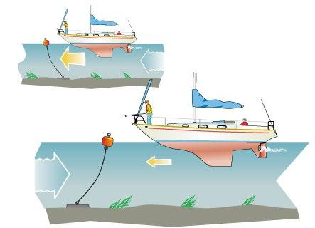
Mooring buoys are generally attached to a ground chain, which in turn is anchored to the sea bed with a heavy object or anchor. Sometimes a buoy can be on its own or on a line of moorings attached to heavy chain that runs along the seabed, this is called a ‘trot’. Quite often, the buoy itself is too heavy to lift, as it will be attached to a heavy riser chain, so you will normally find a ring on top of the buoy, which sometimes also has a pick up line attached. You will tie the yacht to that ring. If you are picking up a mooring in an area that you do not know, or if it is your first time on a yacht, then check the charts and ask for local knowledge about which moorings are strong enough to support your yacht, though often you will find that where there are mooring buoys, they are generally well maintained and on offer for many visiting yachts. In areas where the seabed is especially sensitive due to presence of coral, there are normally strict no mooring or anchoring signs.
Mooring station restriction and maximum vessel size
There are two types of mooring buoys installed in marine protected areas, details of which is described below. It is compulsory to secure the yacht with suitable mooring buoy. Each yacht Gross Registered Tonnage (GRT) and safe working load (SWL) should be considered prior to approaching a mooring buoy. SWL and type of mooring buoys is mentioned on each buoy.
Mooring Buoys Specifications
Two types of mooring buoys are installed on each mooring station along the Marine Protected Area mooring stations. Specification and maximum size of vessel allowed to moor at each buoy are shown below:
Mooring Buoys Limitations
Criteria Type 1: SMB- 1500mm Type 2: SMB2400 mm
Max size 300 GRT 500 GRT
Max current 5 Kts 5 Kts
Beaufort Scale Max
Wind Force Max 6 6
35 Kts/h 35 Kts/h
Available Free board 0.910 m 1.14 m
Picking up a mooring buoy
Preparation All approaching vessels needs to have a boat hook and a mooring rope ready for deployment. All mooring buoys are equipped with a mooring ring and a pick-up line, which can be used for mooring. Please do not lift the pick-up line upwards, rather, pull it laterally toward the boat.
Approaching When you are approaching the mooring buoy, always try and aim into the tide or the wind. Look around you at similar yachts and approach the buoy in parallel to them, or look at the pick-up line which will be showing you the direction of the tide. Keep the buoy to one side of the bow, so you can see it for longer. You can ask the crew to count down the distance to the buoy. Take it nice and slowly, and once the buoy has been picked up, then reverse equally slowly trying to stay on the buoy until the crew have attached the bow of the boat to it. Securing Once you are on the buoy, ideally the boat needs to stay stopped over the buoy to give your crew a chance to attach the yacht to the buoy. You don’t want the load of the yacht to be fully on the boat hook as then it is impossible for the crew to release the hook from the buoy. Pull in on the mooring rope until the main mooring line is reached and then attach to a cleat. If the buoy doesn’t have a mooring line, then use your own line to attach yourself to the ring on top of the mooring. The safest and most secure way of attaching yourself to a buoy is to tie a round turn and two half hitches to the ring on the buoy, if you are planning on staying overnight, then to be even more secure you could use two lines to the buoy.