
4 minute read
Blæing 21


Blæing
Visit the beautiful and spectacular stone landscape of Blæing by the village of Sumba. You may even stumble upon the cave where the sheep thieves hid out in the old days
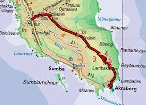
The route starts at “the parking lot” on top of the hill Hesturin, where the road between Lopra and Sumba is highest . Cross the road and walk on the mountain ridge to the east. There are no cairns here; however, visibility is very good in this first leg. Continue in the direction of the big antennae on the ridge.
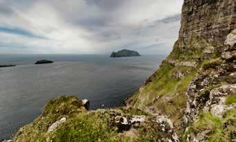
Do, however, take a moment to turn around and look south towards the beautiful 469 metre high Beinisvørð, which is one of the country’s most famous bird cliffs. Beinisvørð is a frequently used motif in Faroese poetry and its rich bird life has also traditionally been an important source of food for the people of the area.
After about one kilometre, you will reach Spáafelli where the large mast is as well as a small building .
Here, you have a view of Víkarbyrgi and Hamrabyrgi, which are abandoned settlements. Local legend has it that Víkarbyrgi was wiped out in 1349 when the plague scoured the Faroe Islands. Only one woman is said to have survived. Before that, Víkarbyrgi was an important settlement complete with its own church and cemetery. It took another 500 years for people to settle in the village again. In early 1900, roughly 40 people lived in the village, but it was deserted again some years ago. You can still see medieval ruins.
Please make sure to select the right direction on Spáafelli because there are two ridges. One goes to the east (to the left), while the other goes in a more southerly or south-easterly direction (to the right). Choose the latter and follow the fence.The ridge roughly follows the road further down the valley on your right-hand side.
Once you have walked about four kilometres you will come to Blæing. The area is unique with a tremendous amount of big and small rocks and stones, which have come down into the valley during the Ice Age. One characteristic of the stones is the bright colour that looks like shiny silver, glinting in the green grass. You go down in Blæingsskarð , which is a passage down from the ridge. There is a story about two brothers, Kaspar and Sjúrður, who hid here in the stony landscape. They had leased land from the priest in Vágur, but because the price was high, they would often starve and had to steal sheep to survive. In the old days, stealing sheep was a very serious crime in the Faroe Islands. The brothers fled from the authorities and hid in a cave in Blæing, which is called Cave Kaspar today .
The cave can be difficult to locate, even for local people, but if you’re lucky (and a bit stubborn) you might succeed. A little hint: When you go down in Blæingsskarð there are traces of a path that goes diagonally down to the right and turns more and more to the right. About a 300-400 metre walk from Blæingsskarð, there is an old stone wall, and then you’re almost there. The cave is about 50 metres straight out from the stone wall. An old iron sign marks the entrance and inside the cave there are many messages and greetings written by young people through the years.
Blæing is a favourite destination for the locals because the climate in the area is mild and warm. The green grass, along with the stones, makes for an ideal playground for children.
When it’s time for you to move on, go back up through Blæingsskarð. You can choose to go back the same way or you can continue along the ridge. Here, you can still enjoy the view of Blæing. Among other things, there is a long stone wall, called Eiriksgarður , and a sheep fold, which is probably built centuries ago. No one knows exactly when or who built them. You can also see Lítla Dímun and Stóra Dímun. On a clear day you can see all the way north to Fugloy, at the other end of the country.
The bird life is rich with Skuas, Oystercatchers, Great Skua and Curlew.
Go down towards the end of the ridge. Then pass the infield on the left-hand side and down to the road in Akraberg. Here, you are on the southernmost tip Duration: Two to three hours (one way)
Distance: Six to seven km
Difficulty: Easy
Maximum height: 462 m
Children: The route is suitable for children. Small children may need a helping hand in the stony landscape
Surface: Partly visible grass path. In Blæing there is a grass path, stones and rocks
Map: 501
of the Faroe Islands. The lighthouse, which was built in 1909, has been of great importance for the safety of fishing vessels and other vessels in this part of the sea. In Akraberg, there is also a weather station and a radio transmitter. There are traces of high-backed fields in eastern Akraberg, which may originate from the Vikings. Local legend has it that around the year 1040, a Frisian boat stranded at Akraberg, and it is said that the crew settled here.
Akraberg had an important role during World War II because of its strategic location with good sea views to the east, south and west. The British had an important radio station in Akraberg during the War and ruins from the War can still be seen.


