6 minute read
3 .2 A Flavour of the Mournes


9.3 miles (15 km)
A strenuous linear walk linking the southern end of the High Mournes to Newcastle via Slieve Binnian, Slievelamagan and the Glen River . Impressive views of Silent Valley Reservoir can be enjoyed from Slieve Binnian and of Ben Crom Reservoir from Slievelamagan, both of which supply Belfast with piped water . The walk starts near Annalong and finishes in Newcastle .
Did you know?
From the top of Slieve Donard, on a clear day, walkers can see out over to England’s Lake District, Dumfries and Galloway in Scotland, Snaefell on the Isle of Man, the Scottish island monolith of Ailsa Craig and the Isle of Arran .
Best place for a quick snack:
The Galley Take Away & Café – Award winning fish and chip shop in the village of Annalong . A range of sandwiches and paninis are also available in their adjoining café . Tel +44(0)28 4376 7253 .
Best place for a drink after the walk:
Percy French Inn - Pub style bistro located within Slieve Donard Resort & Spa grounds in Newcastle . A relaxed atmosphere make this a popular choice for walkers . Tel +44(0)28 4372 1066 .
Day 2: Bearnagh and Meelmore
6 miles (9.6 km)
A strenuous walk in the Mournes taking in the peaks of Slieve Bearnagh and Slieve Meelmore, finishing by walking down Happy Valley and along a section of the Ulster Way . This is a circular walk using the Trassey Track as the gateway to the core of the High Mournes .
Did you know?
There is an annual Hill & Dale series mountain race up Slieve Meelmore and neighbouring Meelbeg . New local runner record holder Stephen Cunningham 22 mins 55 seconds
Best place for a quick snack:
Meelmore Lodge – Set in the tranquillity of the Mourne Mountains at the bottom of the Trassey track, Hares Gap Café & Bistro at Meelmore Lodge offers a wide variety of foods accompanied with wonderful mountain views . Tel +44 (0)28 4372 5949 .
Best place for a drink after the walk:
O’Hare’s – Lively traditional pub in the centre of Newcastle, also serves hearty pub food . Tel +44(0)28 4372 2487 .
22 miles (35 km)
This 2-day long distance linear walking route follows a mixture of forest trails and mountain paths through the foothills of the Mournes, from Newcastle to Rostrevor on Carlingford Lough . This itinerary provides more moderate walking as the route contours the peaks rather than climbing them .
Walker’s Highlight
“Having walked up Butter Mountain, along the Mourne Way, the highlight for me is descending Spelga where the views really open up along the valley at Spelga Pass . Beneath, the River Bann meanders from its source near Slieve Muck, through Spelga Dam and on to Lough Neagh . It’s a great point to view the next section of the walk heading around Hen Mountain and on towards Rostrevor” . WalkNI .com Development Manager Clare Jones
There are a wide range of B&Bs, guesthouses, hotels and hostels in Newcastle and Rostrevor, at both ends of the Mourne Way . There are no significant refreshment stops along the route between Newcastle and Rostrevor but Meelmore Lodge offers hostel accommodation, camping and a coffee shop approximately 7 .5 miles (12km) along the route . The Cnocnafeola Centre based just off the route in Attical also offers prearranged transfers to and from Ott Car Park on the Mourne Way . More accommodation information can be found on page 14 . Note: This walk crosses open hillside with no waymarking so please ensure you are adequately prepared .
Day 1: Newcastle to Ott Car Park 8 miles (12.8 km)
Following the Shimna River out of Newcastle the route heads towards Tollymore Forest Park . From here walkers reach the ‘Brandy Pad’ an old smuggler’s trail up to Fofanny Dam Reservoir . This day’s walking finishes at Ott car park .
Best place for a quick snack:
Sea Salt – Café on the central promenade in Newcastle, not far from Donard Car Park . Uses high quality local produce . Tel +44(0)28 4372 5027 .
Best place for a drink after the walk:
Newcastle is a 15 minute drive away where there are a range of bars and restaurants to choose from .
Did you know?
In 2015 Tollymore Forest Park celebrated its 60th anniversary .
In 1955 it became the first state forest in Northern Ireland to be designated as a Forest Park .
Day 2: Ott Car Park to Rostrevor
18 miles (29 km)
The 2nd day’s walking begins at the saddle between Butter Mountain and Spelga Mountain . Walkers then cross the Rocky River and make their final descent down into Rostrevor village with spectacular views out over Carlingford Lough .
Did you know?
There is a “Magic Road” at Spelga Dam! A car (or any other object that can roll) apparently rolls uphill on this short section, which is not a road as such, but a surfaced entrance driveway to a private area of the dam works . The relevant section however is open to the public and accessible from the passing B27 road . Gravitational anomaly? Optical illusion? Whatever the explanation, it’s an eerie experience!
Download your free Mourne Way Guide
Best place for a quick snack:
Meelmore Lodge – A 5 minute drive from Ott Car Park, Hares Gap Café & Bistro at Meelmore Lodge offers a wide variety of food accompanied with wonderful mountain views . Tel +44 (0)28 4372 5949 . The Mourne Lodge – Will provide good wholesome food and soft drinks if arranged in advance . Tel +44(0)28 4176 5859 .
Best place for a drink after the walk:
The Kilbroney Bar and Restaurant - Located in Rostrevor and well-renowned in walking circles for good hearty food in a traditional pub . Tel +44(0)28 4173 8390 .
Image courtesy of Richard McAleese
19 miles (30.5 km)
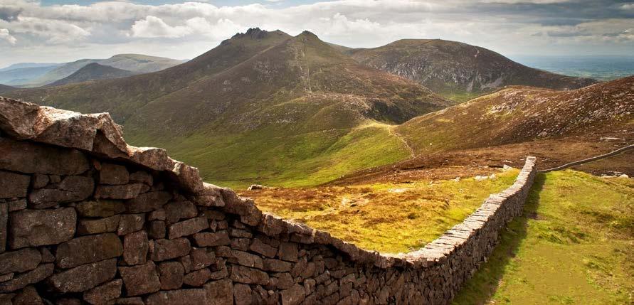
A 1 day challenge following the 22 miles (35 km) of the Mourne Wall . This challenge route incorporates the ascents and descents of 15 peaks in the Mourne Mountains . This challenge certainly isn’t for the faint-hearted however it rewards walkers with a truly unique experience .
In the late 1980’s hostellers in the area started an annual challenge walk, following the Mourne Wall along the mountain peaks in a single day . Over the years this event grew in popularity and the local hostels used it as a fundraising event . It eventually grew from 50 or 60 people taking part to 3,000–4,000 bringing thousands of supporters with them along the route . However, the challenge event was eventually cancelled due to very severe erosion along the route . It is still possible however to roll back the years and take part in this challenge in your own small groups (no more than 12 people) .
This 1 day itinerary provides a highly challenging route taking in 7 of the 10 highest mountains in the Mournes and Northern Ireland .
Best place for a quick snack:
The Galley Take Away & Café – Award winning fish and chip shop in the village of Annalong . A range of sandwiches and paninis are also available in their adjoining café . Tel +44 (0)28 4376 7253 .
Best place for a drink after the walk:
The Harbour Inn - Beside the Annalong Cornmill, overlooking the harbour, this pub/restaurant offers thirsty walkers a welcome drink, with entertainment at weekends . Tel +44(0)28 4376 8678 .
Did you know?
The Mourne Wall was originally built in an effort to keep cattle and sheep out of the water catchment area of the Silent Valley reservoir .


