13 minute read
Auckland Walk: England Walkway
A ramble on Anzac Day
Hugh P. Kemp and Bonnie take on the Point England Walkway
Advertisement
While living in England, I choose ANZAC day, a SatI learned to ramble. urday, inviting a compliant and The English can talk enthusiastic member of my bubble, incessantly about Bonnie, to join me. the weather, but this is not the Bonnie drives her shoulder into rambling I mean. To ramble: to a fresh pile of horse poo as soon find paths, ancient and modern; as we are through the first kissing to succumb to the primal urge to gate of Meadowbank Pony Club, at explore, to discover new horizons the beginning of the Point England of culture, history and geography; Walkway. “She’ll wash off in the to spend a day with nothing more tide” I console myself. than a map, sometimes a compass, The horses stamp in protest at a bird identification book, good her presence, and I put her back on walking shoes, and curiosity. her leash. The rising sun, glorious
Tired of Covid19 lockdown in in its ANZAC memories invites us Auckland for all of April, 2020, it down the hill. A distant bugler’s was now time to ramble. Last Post drifts across Glen Innes
But why not a Ramble? Big R. below. Like in England. I’ll improvise. I We drop down Apirana Reserve, could join up the parks, green into Eastview, then Taniwha, and belts, coastal strips, lookouts, rugby along Tom Court Memorial Walkway fields, and children’s playgrounds. in Maybury Reserve, a grand Above: Pretty colours of Glover Park in Autumn.
avenue of firey gold and orange trees saluting us. We are then confronted with a construction site: the council is working on drainage and stream rejuvenation. “Find a path” I command Bonnie, who jumps into the creek. Improvising, we push around through tall wet grass, emerging on Elstree Ave, just short of the Glen Innes swimming pool.
Its vacant carpark is a memorial to days of human contact and hurried fitness. We discover a lake behind, teaming with birdlife: mallard ducks just sitting, juvenile gulls learning to fly, kingfisher slyly surveying the scene and two herons standing guard on a log. Indignant plovers screech in protest at Bonnie, while a squadron of pukekos lifts awkwardly into the air, their legs trailing behind them. We now have a choice:
take the northward track through bush following the tidal creek and broken back fences or cross the fields to the new cycle way on the Tamaki Estuary. Today we choose the latter.
We stride out across the vast acreage of playing fields, now silent in their viral neglect. “We need our space”, signs diplomatically inform us, on behalf of groundnesting dotterels. Our fence-line route takes us beside intimidating and creaking macrocarpas to a congested shared cycleway, that now winds its way from Point England to Wai O Taki Nature Reserve.
“Ah the ocean”, thinks Bonnie, pointing her nose to the beach, and disappears to grab a lengthy piece of driftwood, which she hauls up the bank to show me. She trots down the middle of the cycle way, log firmly in mouth, creating a two metre bubble of her own. Cyclists skirt around her, pedestrians pause and wait, and children in pushchairs point. Bonnie drops it at the foot of the seabird pou at the end of the walkway, an offering to the mythical guardian of the coast.
Tamaki Estuar y had once been the main route between the Waitemata Harbour and the Manukau Harbour. Many waka would have travelled up this body of water that I now pause to survey. I imagine canoes of Maori warriors paddling in rhythm, disappearing up under the Panmure Bridge, to the portage route of Otahuhu, New Zealand’s narrowest point.
In the old days, when no virus was around, I kayaked several times up the same route, past the waka ama jetty, waving to intense rowing crews from local colleges. “You have to touch the motorway bridge with your paddle” I tell my kayaking partners: “for the journey to count”.
Once a pod of dolphins emerged
and then they were gone. I survey this sparkling body of water: it is eerily quiet. No movement. Boats sit lifeless in the still morning air, tied up in the channel over at Half Moon Bay.
The sandspit of Tahuna Torea draws me, a band of white sand, layered over with dark green pohutukawa separating ocean and sky. Teaming with birdlife, dogs aren’t allowed, so I turn up the hill amongst the houses. I walk now by intuition, searching for a gapin-the-fence back down to the coastal track.
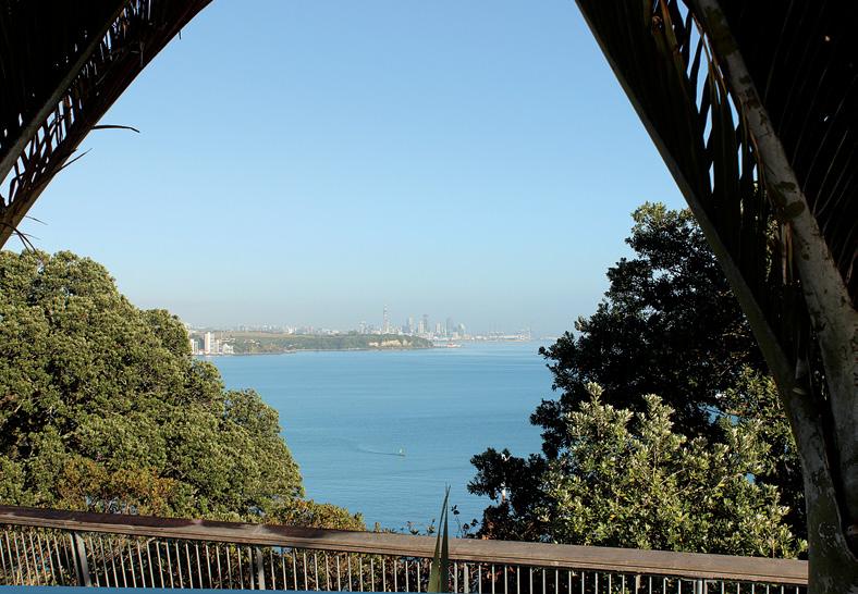
I find a path off Vista Crescent, but No Dogs Allowed. “Your registration fees pay for those signs”, I inform Bonnie. We circle down to Roberta Reserve, to discover it is an “off leash” area. “I take it back”, I apologise, and Bonnie races for the water. I look longingly at the closed patisserie on Roberta Avenue: in better days Above: Looking towards Auckland City from Achilles Point. Below: Dawn at the beginning of the Point England Walkway.
this will be a good breakfast stop.
The tide is lapping the rock wall, and I ask a local if I could have come down the Vista Crescent walkway to the coastal track. “Oh yes, and there’s a nice little beach there for the dog”, he replies. His white Labrador greets my black Labrador. We keep two metres apart.
Bonnie and I stick to the coast and head around past the Glendowie Boat Club: the road becomes a pathway of concrete slabs pushed up at awkward angles by old pohutukawa roots. There are stairs down to secluded scraps of beach on my right.
Locals look after this track like it’s their own private yard. I emerge onto Clouston Street where people


A ramble on Anzac Day
are milling around as if something has just happened. Two men in black suits are greeting people from a distance. I wonder if someone has just died, and they’re waiting for the hearse. Large red poppies decorate the fences. “Have you just had an ANZAC day service?”, I surmise. “Yes”, someone replied: “out here on the street.” I dodge a skateboarder and ask if there’s an entrance to Churchill Park nearby. This vast expanse of green on my map belies the housing crisis in Auckland: how could so much land be set aside for so much park? The notice on the gate calls it a farm. I’m delighted. Churchill Farm is surrounded by Glendowie and St Heliers suburbia. I drink in the views back across the city, westward. The Skytower and the container wharf cranes reach for the sky in celebration of nothing to do. “This corona virus must be good for the planet”, I muse to myself: “she can breathe for a while”. I call out to a boy on a mountain bike to check which path will lead me to Glover Park. “Top one. Past the school”, he shouts and disappears into a fold of land amongst the macrocarpas. I recruit the St Heliers water tower in the distance as my navigation point. Biddy-bids stick to Bonnie’s fir. I meet a man who confesses “my dog’s a farm dog, but he’s scared of cattle”. I see the Huntaway pacing nervously at a gate in the distance. “He won’t come to my call when there are cattle around”. Bonnie trots by a dozen steers and the whimpering Huntaway, head held high, still reeking of horse poo. I take a wrong path and emerge back into suburbia too far east. Karaka Bay is down the cliff: it’s a place I’d like to visit some time, as it was where local Ngāti Whātua hapu thumb-printed their endorsement of the Treaty of Waitangi. I’ll leave that for another day: the history that beckons me at Glover Park will be enough. One of Auckland’s 49 volcanoes, Glover Park is a crater that was a swamp long ago, now drained, filled and turned into an athletics track. The rim on the ocean side was a lookout for Maori monitoring movement on the harbour, and up the Tamaki Estuary. 42 Walking New Zealand, issue no 268 - 2020
Two pa once dominated the volcano’s rim, and the terraces are still visible, although now mown to a crisp green. I take the long route around, stopping at the flattened summit and watch a young boy show off his back flips to his Dad. Te Pane-o-horoiwi – the head of Horoiwi is to my left, known also as Achilles Point, but I can’t see it because of the dense housing that covers the headland. I breathe in, noting the land I stand on is drenched in blood: a battle once took place here between Ngāpuhi from the north and the local Ngāti Whātua. I loop around again and arrive at Achilles Point. Bonnie drinks enthusiastically from a half full water bottle left on a bench.
A family wanders up Cliff Road to the point, and I watch from a distance. Forced isolation and a recommended daily walk – “within two kilometres . of your house” – has brought families together. I have broken the rule: I check my phone and note that I have walked 14 kms. They gather under the nikau palms and chatter about the view: Skytower backed by the smudge of the western Waitakere Range on the horizon; around near North Head reefs are appearing with the receding tide, brown flecks amongst the sparkling expanse of water.
There is not a boat on the harbour, this “City of Sails”. Rangitoto immediately north of us and Tamaki Estuary opening now on our right, filled with kai moana and memories. A breeze rustles unswept leaves at my feet.
Bonnie can smell the salty welcome of St Heliers Beach below us and gets restless. Now exhausted, she trots along,
Above: Half Moon Bay Marina from Tahuna Torea. www.walkingnewzealand.co.nz
ignoring people and other smells: we cross Vellenoweth Green – where Christmas happens, and the Round the Bays annual coastal run terminate. I stop and vicariously join in with two parents who have just-walking twins and are lightly kicking a football around. The chuckles of the children are a reminder that our humanity will return, and all will be well. We push up The Parade to Dingle Dell Reserve. A pungent waft of horse manure surrounds us: the tide has not cleansed the dog.
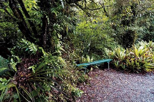
Dingle Dell supplements St John’s Bush and Kepa Reserve, a trinity of native bush across East Auckland. The smell of the earth, the texture of the bark, the shape of the trees and the song of the tui ground me firmly in this place. We enter reverently, dog and man revived by the coolness and the shadows: nature’s cathedral, in all its jumbled glory.
I twitter to two fantails, dancing by the track. I discover on exiting that our track had technically been closed due to Kauri die back. But no disinfectant to walk through or brush to scrape boots on. “It’s the pigs in the Waitakeres, not us”, I say conspiratorially to Bonnie. She wags her tail.
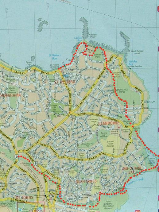
The way home is now all asphalt, houses, and closed shops. South along Long Drive, right onto St Helier’s Bay Road, and eventually left on to St John’s Road, and we’re back at the beginning. If it had been open, I’d have bought myself a large smoothie at Sunhill Fresh Market. But it isn’t, so I don’t. We have walked 19 kilometres, stitching together official tracks and improvised routes. The neighbour commends me over the fence, as I boast of my ramble. “But your dog rolled in something”, she announces.
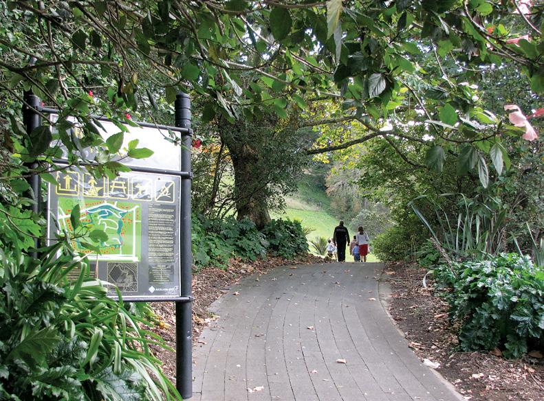
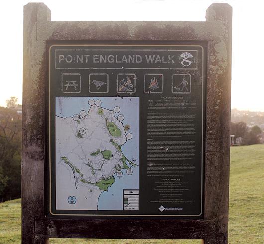
It takes two days to scrub the dried horse poo out of the dog’s collar. Above: Point England walk information board. Fact File
Estimated Walking time and distance: 19 or so kilometres, or around four hours.
Attractions: Urban and rural contrasts. Farmland and bush. Coastal walkway and views. Maori cultural history. Birdlife in abundance.
Where to start and leave the car: You can enter the circuit described above pretty much anywhere you decide. However, there is plenty of parking at Sunhill shops (Sunhill Garden Centre and Sunhill Fresh Market) by the beginning of the Apirana Reserve and Cycleway, near the Meadowbank Pony Club. Opposite Stone Direct.
The beginning of Point England Walk is clearly marked on a notice board. There is an unobstructed spectacular sunrise view from the beginning of the walk. For more information, visit the Auckland City Council website: https:// www.aucklandcouncil.govt.nz/ parks-recreation/get-outdoors/ find-a-walk/Pages/point-to-pointwalkway.aspx
From the 2nd of each month you can now view the latest issue two weeks before stores. Walking New Zealand magazine online for USD.99c at http://www.pressdisplay.com/ pressdisplay/viewer.aspx
God’s cocaine - the addiction of the Camino
The Camino Way is a gain her support for the venture pilgrimage of 800 kilometres but sadly she passed away before stretching from St Jean Pied he left. de Port in France across northern Wisely Terry trained hard before Spain to the city of Santiago. he left, knowing he had to cover
Ever y year thousands of 25 kilometres a day regardless walkers set off to conquer this of the weather, sore muscles and extraordinary journey but one injuries. Palmerston North man walked it He chose to stay at albergues three times in twenty two months. where he often shared bunk
Terry Wilson, worked mainly in rooms with up to sixty other the New Zealand timber industry people as he had a strict budget before retiring. After experiencing which had to cover a mandatory a crisis of faith he sat down to beer each night at the local cafes! flick through Netflix and came During this first journey Terry across a film called “The Way’ met with pain and passion, love starring Martin Sheen as a father and loyalty, hope and healing. whose son died on the first day of When he reached Santiago after walking the Camino four weeks, he’d made some
This film inspired Terry to travel lifelong friends. this journey and seek the answers Returning to New Zealand, Terry to his crisis. It was also a catalyst was approached by an Australian to fund raise and seek awareness documentary producer and asked of Cystic fibrosis, a disease which if he would be keen to walk the tragically took the life of his Camino again for a film. seventeen year old granddaughter After some thought and the Maddie. opportunity to include Maddy’s
Before she died he was able to father on the trip, Terry agreed to travel the Camino once more. The film called ‘Camino Skies’ was shown all over New Zealand with Terry and some of the other participants talking about their experience at various venues. Back home from this trip, Terry was hard pushed to settle down to a routine retired life so when the eldest of his four daughters expressed a wish to walk the Camino he set off with her for a third time. Every journey was different for Terry and he decided to write an honest account of the three pilgrimages. His book ‘God’s Cocaine - The Addiction of the 44 Walking New Zealand, issue no 268 - 2020 Camino’ not only offers practical advice but a very subjective travelogue. It gives a true insight into the spiritual, mental and physical strength required for this walk.
His extraordinary fortitude in the face of personal loss and his pragmatic attitude make for a compelling narrative. The Camino Way brought out the best and the worst in people he met.
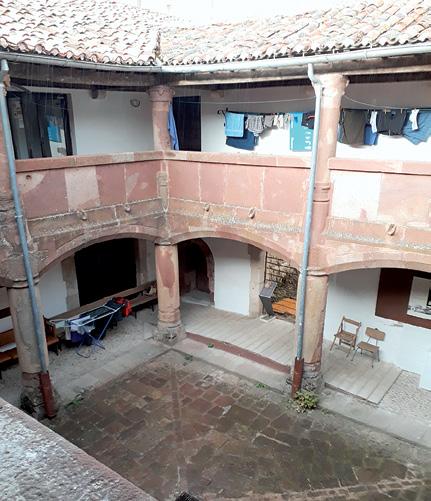
H e e n c o u n t e r e d s o m e extraordinary situations that might be termed miraculous by some readers and plain coincidence by others but above all he remained stalwart in his ambitions to complete a trio of truly remarkable journeys. Below left: One of the albergues where Terry stayed.
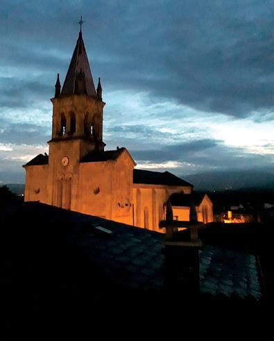
Above right: The destination in
Santiago., Spain.
Available from Rangitawa Publishing, rangitawa@xtra.co.nz, Kindle, Amazon books or order from any book store.

