4 minute read
New Zealand Walks: Ohakune Old Coach Road
Ohakune Old Coach Road steeped in history
Originally used by horsedrawn coach as a connecting route between the two rail heads of the unfinished North Island trunk line, the Ohakune Old Coach Road is steeped in history.
Advertisement
This fantastic multiterrain cycle and walking track forms part of The New Zealand Cycle Trail and provides a great family-friendly cycle that is steeped in history.
The 15km track winds beneath the cool canopy on the lower slopes of Mount Ruapehu and offers a rare opportunity to get into the heart of one of the few remaining sections of virgin native forest in the North Island.
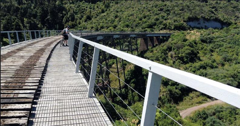
The trail was built in the early 1900s to ferry passengers by horsedrawn coach between the two railheads of the unfinished North Island trunk line. The cobbled route became obsolete with the completion of the railway and was lost to the forest for almost 100 years. Following its rediscovery and restoration from 2002 onwards, Ohakune Old Coach Road has been steadily gaining popularity with cyclists and walkers for its diversity, the rich history that is recounted along the route and the unique opportunity to cycle across the impressive Hapuawhenua Viaduct.
In the early 1900s this was the largest wooden curved railway bridge in the world.
The terrain varies greatly along the route, ranging from well-constructed pathways of varying widths to the original cobblestoned roadway. Sections can become particularly muddy and slippery following heavy rain. It is recommended that you seek advice before cycling this route if you are less confident on a bike.
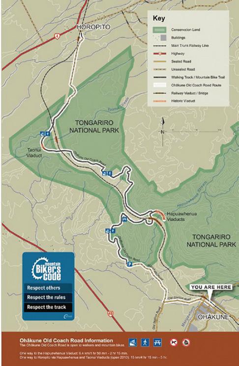
Due to the lineal nature and the gradient of this cycle/walkway, the easiest and most rewarding way to tackle this ride is one-way from Horopito. Bikes and transport can be organised from Ohakune.
Ohakune Railway Station to Marshalls Road carpark
From the station follow the footpath to the Mangawhero River Bridge and cross over onto Old Station Road.
Continue about 1.5 kilometres and turn right onto Marshalls Road. Rongokaupo Wetland and picnic area, a community project under development, is situated about 350 metres before Marshalls Road carpark. The track continues from the car park. Above: Cyclists on one of the two historic railway viaducts. Bleow left: A lone walker takes in the view. Opposite page above: Cyclist on the road with Mt Ruapehu in the background.

Marshalls Road carpark to Hapuawhenua Viaduct
From the car park the track follows the Ohakune Old Coach Road, weaving its way through rolling farmland with views over the spectacular Ohakune Basin.
It then heads into native bush toward the Hapuawhenua Viaducts. Cobblestones (setts) are still evident along the track.
Explore the Hapuawhenua Tunnel and marvel at the workmanship of yesteryear.
The track climbs up to a ridge before dropping into the Hapuawhenua Valley. There are good stands of kahikatea, rimu, mataī and ponga along the way. From this point the two viaducts come into view.
Walk the historic Hapuawhenua Viaduct (cyclists dismount on the viaduct) and enjoy both old and new viaducts and native forest surrounds.
The limestone cliff that is visible high up on top of Raetihi Hill is a reminder that this area was once under the sea. From here you can return to Ohakune or carry on to Horopito.
Hapuawhenua Viaduct to Horopito
From the western end of Hapuawhenua Viaduct access the cycle trail to Horopito.
The trail passes through a beautiful section of native bush before coming out on the original Old Coach Road again. This is known as the Skyline section; some kilometres of it can be very muddy and difficult for less experienced riders.
On the way to the highest point, the trail passes the old quarry which supplied much of the rock for the cobbles as the old dray road was upgraded to a coaching road in 1905.
At the top of the ridge, you again pass by some magnificent rimu and rātā trees and there are beautiful views over farmland and hills.
Throughout this part of the trail, there are old campsites established when the dray road was upgraded. While not much can be seen of them, they are a reminder of the hardships the road workers and their families faced while living in canvas-covered houses in the midst of a cold, wet rainforest.
Shortly after crossing the bridge over a beautiful spring-fed stream, there is a grassed picnic area surrounded by rimu and tawa trees. This is an ideal place to stop for a rest before continuing through the forest, down the hill to Taonui Stream and under the new Taonui Rail Bridge.
The trail follows the stream down to the historic Taonui Viaduct. From the top of the viaduct, you follow part of the old railway alignment through to the present day railway line. The railway line must be crossed at the designated crossing point. Use caution when looking for trains that regularly use the line.
From the railway line, the next points of interest are the old viaduct abutments across Haeremaere Stream. From here the trail crosses the stream and follows the Old Coach Road through to Horopito.
This is a shared-use track. Follow the mountain bikers code: respect others, respect the rules, respect the track. As the track passes under the main trunk line, be conscious of rail traffic and flying objects from passing trains. For your safety do not enter the railway corridor.

Fact file
Distance: 15km Difficulty: Moderate Average Time To Cycle : Three hours one way Average Time To Walk: Five hours one way Start: Ohakune or Horopito Finish: Horopito or Ohakune


