
13 minute read
Hike It


Hiking and Helping Leading the Way
Summer is ideal for multiday adventures, when the high country has melted out and the days are long and sunny. But with this year’s late, heavy snows, some of our favorite routes may melt out later than usual. Luckily, WTA’s trip reports help you get a good sense of conditions as they change, Hikers in our community lead in different ways, including volunteering their time to writing the hike recommendations in the following pages. But being a leader can also be as simple as being a good role model on trail and in camp and by writing trip reports of your own. With a little help from each other, we can all have safe, meaningful and memorable trips this summer.
Chain and Doelle Lakes
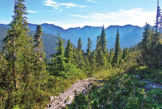
Stevens Pass area
A steep and rough-at-times trail leads hikers into some of the loneliest, yet most stunning, lake basins within the Alpine Lakes Wilderness. By Lindsay Leffelman Sitting beneath the spire of 6,807-foot Bull’s Tooth, remote and rugged Chain and Doelle lakes offer backpackers a chance to leave the crowds behind and admire the stunning scenery of the Alpine Lakes backcountry. Begin by hiking the well-traveled Pacific Crest Trail through the heart of the Stevens Pass Ski Area. Ascending across open slopes and under towering ski lifts, reach a 5,150-foot ridge in just over 2 miles. From the crest, gently switchback down the other side of the ridge across more ski slopes. In another mile, after crossing a service road and power lines, the human-made elements diminish and the true wilderness experience begins. Now inside the boundaries of the Alpine Lakes Wilderness, pass by quaint Lake Susan Jane and continue climbing to a junction with the Icicle Creek Trail at just under 5 miles from the trailhead. Follow the Icicle Creek Trail as it circumnavigates the shores of Josephine Lake. Descend briefly, but steeply, to the lake’s outlet stream. Continue descending through thick forest for just over a mile, reaching an intersection with the White Pine Creek Trail. Remain on the Icicle Creek Trail.
At just over 8 miles from the trailhead, come to yet another trail junction, this time with the Chain Lakes Trail. Prepare yourself to rapidly regain the 1,000 feet of elevation lost and then some. Without switchbacks, the trail steeply climbs about 2,000 feet in 2 miles, bringing you to the first of the Chain Lakes. Traverse tranquil meadows as you make your way past the sparkling lakes and many excellent camping spots. Continuing on and climbing talus slopes, you soon reach a gap between the two lake basins. From the gap, enjoy the view to Upper Doelle Lake below and stunning peaks above. Stay to the right and descend steeply to the shores of the upper lake, then continue less than a half mile farther to several good camps at the lower lake.
Distance: 24.6 miles roundtrip ◆ Elevation gain: 5,000 feet Highest elevation: 6,200 feet Map: Green Trails 176S: Alpine Lakes West-Stevens Pass Permit: Northwest Forest Pass; self-issued Wilderness permit ◆ Dogs: Leashed Info: wta.org/go-hiking/hikes/chain-lakes-trail Trailhead: Drive US 2 to Stevens Pass. Park in the large lot just east of the Stevens Pass Ski Area buildings on the south side of the highway. The lot is signed for the Pacific Crest Trail.
NEARBY HIKES
Lake Augusta: Sitting in a cirque beneath Big Jim Mountain, Lake Augusta offers alpine views, wildflowers and larches. Expect a bit more solitude than in other backpacking locations in the Alpine Lakes Wilderness, but also be prepared for a trail that needs some maintenance. (15.8 miles roundtrip, 4,750 feet elevation gain) Necklace Valley: A string of lakes tucked in a forested valley await backpackers who don’t mind a steep, rocky ascent. With multiple campsites along the way, this route can accommodate the many hikers who travel this way. (18.4 miles roundtrip, 3,300 feet elevation gain) Josephine Lake: This lake is on the way to Chain and Doelle lakes and can be done as a day hike. Get a sampling of the Alpine Lakes Wilderness with this shorter option. (10.4 miles roundtrip, 1,800 feet elevation gain) Photo by Anna Johnson
Elip Creek Loop
Olympic Peninsula
Elip Creek is a challenging loop hike through one of the Olympic’s most remote corners. By Wes Partch The counterclockwise route begins at the North Fork Quinault Trailhead and follows the river for 6.5 miles, passing beneath massive trees and over a ford at Wild Rose Creek, something best left for late summer. A mile after the ford, there is another ford, this time of Elip Creek, with a campsite and trail junction on the other bank. This makes a good first-night spot. Turn left now onto the Elip Creek Trail and follow the switchbacks along a narrowing ridge before topping out in pleasant meadows at around 9 miles. The way passes over gurgling brooks between stands of trees before meeting the Skyline Trail at 11 miles. Enjoy views deep into the interior of the park. Turn left onto the Skyline Trail and follow it over a forested ridge before descending into a lovely open basin with two picturesque tarns between mountain hemlocks that frame the distant peaks. At 14 miles, the trail comes to a spacious campsite named Three Lakes. There are several tent sites and a privy near the lakes, which are really two ponds beloved by a chorus of frogs. The route now descends along the Big Creek Trail for 7 more miles, passing by the world’s largest yellow cedar. Farther on, the trail meets a significant stream that must be forded. Again, this is safest to do in late summer. Now the trail enters lush rainforest and passes by Irely Lake before arriving at the Big Creek Trailhead. Turn left on the road and walk less than a mile back to the trailhead to complete the loop.
Distance: 21 miles roundtrip Elevation gain: 4,100 feet Highest elevation: 4,000 feet Map: Green Trails 166: Mount Christie Permit: Backcountry camping permit ◆ Dogs: No Info: wta.org/go-hiking/hikes/elip-creek Trailhead: From Hoquiam, drive north on Highway 101 for 38 miles, then turn right at milepost 126 onto South Shore Road. Continue down this road for 12.9 miles (paved for the first 8 miles and then graveled). Turn left to cross the Quinault River Bridge, then turn right onto North Shore Road. Continue 3.5 miles to the road end at the trailhead and a ranger station with ample parking.
NEARBY HIKES
North Fork Quinault to Halfway House: The first part of the Elip Creek Loop can be hiked as a delightful day hike through a majestic maple grove to a great lunch spot with river views. If Halfway House is too far, explore the forest for as long as you want before turning around. (10.2 miles roundtrip, 300 feet elevation gain) Enchanted Valley: This trail follows the East Fork Quinault River to an iconic and scenic meadow with a historic chalet. (26 miles roundtrip, 3,700 feet elevation gain) Graves Creek to Lake Sundown: Instead of going to Enchanted Valley, hang a right on the Graves Creek Trail, then continue on a rugged route to Sundown Lake. (16 miles roundtrip, 3,300 feet elevation gain) Photo by Wes Partch

Devil’s Dome Loop
North Cascades
Dry, subalpine ridges, old-growth forest, massive flower-packed meadows and glaciated peaks make this trip a nonstop North Cascades life-list backpack. By Austin Smith From the trailhead, follow this loop clockwise, descending to Ruby Creek and turning left. This old roadbed winds along the hillside, slowly gaining elevation to Hidden Hand Pass. Follow the East Bank Trail north along Ross Lake as it slowly drops 900 feet and eventually comes level with the lake. There are several campsites along the lake, all of which require a backcountry camping permit. At Devil’s Creek Campground, turn onto Devil’s Ridge Trail, which is generally well maintained and relentless in its 5,200-foot ascension to the summit of Devil’s Dome. Along the way, amazing views of the north face of Jack Mountain and Nohokomeen Glacier will keep you entertained. The first potential opportunity for water since leaving the lakeshore is at the questionably named Dry Creek Pass. A long stretch of over 15 miles connects Devil’s Dome and Devil’s Park. For the most part, the trail traverses above tree line with huge views and flower-packed meadows. Water can be scarce along here, so plan accordingly (Devil’s Pass has water a few hundred yards down the north side). After passing the turnoff for Anacortes Crossing, the trail drops 1,000 feet to a decent campsite with the first truly reliable water since leaving the lake. Over the next several miles, you’ll make your way alongside Jackita Ridge through endless flower meadows with stupendous views of the rugged eastern flank of Jack Mountain. Devil’s Park shelter makes a good place to camp and generally has water. Descend from Devil’s Park for about 4,800 feet through meadows and old growth. Continue downward on your loop to Canyon Creek, then complete the last 2 miles along Ruby Creek back to the trailhead. Seasonal tip: Early summer can still be snowy at these heights, and midsummer can be buggy. Autumn has brilliant colors and few bugs, but the days are getting shorter and cooler. Many sections of this trail are dry, so research reliable water sources for your trip and prepare to carry extra water.
Distance: 43 miles roundtrip Elevation gain: 13,000 feet Highest elevation: 6,980 feet Map: Green Trails:16SX: North Cascades National Park Permit: North Cascades backcountry camping permit Dogs: No Info: wta.org/go-hiking/hikes/devilsdome
Trailhead: Take Highway 20 from Marblemount to the Ross Lake Dam. Continue past the dam for 4.5 miles to the East Bank Trailhead on the north (left) side of the road.
NEARBY HIKES
East Bank Ross Lake: The beginning stretch of the Devil’s Dome Loop makes for a great day hike or an overnight with a camp on Ross Lake (permit required). Follow the East Bank Ross Lake Trail for 2.4 miles to a junction, where you’ll turn left for another half mile to the lakeshore. (6 miles roundtrip, 710 feet elevation gain) Desolation Peak: This dry, strenuous hike climbs from the shores of Ross Lake to the lookout building on Desolation Peak, where poet Jack Kerouac famously served as a fire lookout. (9.4 miles roundtrip, 4,400 feet elevation gain)
Fourth of July Pass via Thunder Creek:
This is a more relaxing backpacking option through gentle creekside terrain, followed by a climb to Fourth of July Pass, where you can take in the majesty of the North Cascades. (11.2 miles roundtrip, 2,400 feet elevation gain) Photo by Jonathan Chadburn
Trails Less Traveled with Craig Romano
Barnaby Buttes

Kettle River Range
One of the loneliest spots in the southern reaches of the Kettle River Range, Barnaby Buttes offers sweeping views across northeastern Washington and excellent chances for spotting some of the area’s mega fauna. By Craig Romano There are two routes that lead to the former lookout tower on the Buttes’ north peak. The approach from the east is the preferred route. The way starts on an old fire road climbing through a thick stand of lodgepole pine and western larch. The route is oft-littered with moose and deer droppings and plenty of tracks left in the tread by these ungulates and the predators that pursue them — particularly cougars and coyotes. The trail eventually enters the 1988 White Mountain burn zone. New greenery has since reclaimed the large burn area, but plenty of silver snags and blackened logs still remain, providing excellent habitat for insects and birds.
At 2.6 miles, the trail comes to a junction with the Kettle Crest Trail. Head right for 0.8 mile and reach a junction. Now follow a fading trail right to the old lookout site. If you lose the way, just go north across an open slope, aiming for the 6,534-foot summit graced with aspens and junipers. All that remains of the fire lookout is a concrete stairway. Sit on it and enjoy the view east to the Selkirk Mountains; south to White Mountain and Grizzly Mountain; west to Thirteenmile, Fire, Granite and Moses mountains; and north to Edds and Bald mountains. See too if you can catch a glimpse of Roosevelt Lake shimmering below to the east.
Distance: 7.4 miles roundtrip Elevation gain: 1,975 feet Highest elevation: 6,534 feet Map: USGS Sherman Pass Guidebook: “Day Hiking Eastern Washington” (Mountaineers Books) Permit: None Dogs: Leashed Info: wta.org/ go-hiking/ hikes/barnabybuttes
Trailhead:
From Kettle Falls, travel west on Hwy 20 for 14 miles, turning left onto Forest Road 2020 (South Fork Sherman Creek Road). Continue 6.5 miles and bear left onto FR 2014 (Barnaby Creek Road) and after 0.3 mile turn right onto FR 2014-500 (high clearance necessary). Then drive for 2.4 miles to the trailhead.
Craig Romano is a guidebook author, craigromano.com. Photo by Craig Romano

Trip Report Corner
Spotlighting a great report and celebrating its writer
Castle Rock
Region: Central Washington Trip reporter: ZhuckYu
In each magazine, we
like to highlight the Help fellow great work of our trip hikers. File a reporters by sharing a trip report at:
particular trip report. wta.org/
This time, we’d like tripreports to give a shout-out to Yuri Zhuck, aka trip reporter ZhuckYu, who wrote about a great hike at Castle Rock. In his report he provides tons of great information to help other hikers have a successful trip here. From notes on considerate parking to the nuances of dog rules to signage on trail, this report paints a detailed picture of a visit to this trail next door. If you do take a hike here, be sure to stay off muddy trails and respect private property boundaries, especially as you get near the top. Yuri is an outstanding trip reporter who has been helping hikers know the conditions on trail for years, and he finds that hiking is a way to connect to Washington during his regular visits. “As a visitor to Washington, I believe hiking is the best way to dive into local traditions and embrace all the fantastic variety of nature the Pacific Northwest has to offer,” he said. Yuri sees trip reports as a way to help other hikers do the same. “I am passionate about sharing knowledge and helping people, and I do rely heavily on fellow hikers’ reports when choosing my next hike. So I really try to make my reports useful and fill them with information I would usually expect to find in other reports: trail conditions, timing, parking, amenities, safety tips, etc,” Yuri said. His visits to Washington have never happened during summer, but that will change this year. “I’m looking forward to hiking some of the high-elevation trails that have been sitting in My Backpack for a while.”
Summer tips for trip reports
Each season brings different conditions to Washington trails. This summer, as you write up your hikes, including summer-specific details in your trip reports will help your fellow hikers know what they’re getting into. Here are some specific details you can share that are especially helpful in the summer.
Sun exposure: Let your fellow hikers know if portions of a trail are exposed or especially hot, so they can plan proper sun protection or plan to cover that ground during the coolest part of the day. Bugs: Mention if there are mosquitoes or other plentiful bugs, so other hikers can be prepared for the conditions.
Leftover snow: Snow lingers in some areas. Provide a detailed description of any snow you encounter on trail so your fellow hikers know what to expect. Water: Knowing where reliable water sources are is an important part of planning for a trip, especially for backpacking. You can help other hikers by providing descriptions of reliable water sources and dry sections of trail. Backup plan: If you arrive at a full trailhead, say when you went. If you know one, provide the name of an alternate trail nearby (and ideally less popular) to give other hikers a backup plan if they encounter the same thing.


