


Mark Collins, Chair
Andre Dove, Vice Chair
Justin Davis, Commission Member
Bill Campbell, Commission Member
Don Mitchell, Commission Member
Larry Bowman, Council Chair
Veronica Messing, Vice Chair
Hank Bynaker, Councilmember
Kevin Richey, Councilmember
Dave Malet, Councilmember
Davin Perry, Councilmember
Jennifer Morton, Councilmember
Albert Tripp, City Manager
Kevin Anderson, Public Works Director
J.C. Kennedy, Parks and Recreation Director
Heather Trautman, Planning Director
Zachary Becker, Associate Planner
As part of the City of Airway Heights 2023 Comprehensive Plan update a new vision statement and plan framework is included. The updated vision statement is informed by community input, plan priorities (i.e., the “big ideas”), and best practices. The vision statement is connected to the plan priorities by specific goals, policies, strategies, and actions within the plan elements. Each Plan Element addresses strategies to implement the vision and applicable “big ideas.”
The City conducted multiple public engagement activities from 2021-2023 for the development of the Comprehensive Plan. These activities included:
• Postcard to property owners/residents explaining the engagement activities in the summer of 2021
• Outreach and information booth at Airway Heights Day
• Series of seven Facebook Live/Zoom Engagement Events on each chapter
• Online survey for the public’s vision of the City
• Online survey of land use alternatives
• Online survey on transportation issues and preferences
• Open House on the draft plan with online engagement
• Public meetings and workshops with the Planning Commission and City Council throughout the process
Throughout the various outreach efforts, the top mentioned elements were sidewalks and paths, attention to water quality and utilities, more jobs and local businesses, and more parks and recreation.
In addition, the survey question also asked for feedback on the existing vision statement:
“The City of Airway Heights is a great place to raise your family, engage in community, and make memories. We are a safe, interconnected community that cultivates a sense of belonging through maintaining our small-town feel where neighbors are friendly, welcoming, and willing to help each other. Airway Heights is a city where individuals, families, and businesses plant roots because they feel connected to the community, and they can support the lives they envision.”
Respondents generally liked the vision statement, with some suggestions for additions such as addressing homelessness and the environment, as well as incorporating artsy and fun elements. Suggestions for updates from the planning consultants include making a stronger connection between the vision statement and plan priorities to create more momentum towards action and implementation of the plan while still retaining many of the themes that people like with the current vision statement.
The proposed vision statement retains many of the same themes as the existing vision statement but adds more connection to the planning priorities and desired outcomes identified during the update process. The ten “big ideas” reflect community priorities for the next 20 years, from 2023 to 2043, and are addressed in specific plan elements.
People love Airway Heights as a great place to live, work, and visit for its small-town feel, inclusivity, and strong community connections. Airway Heights is a compact and walkable community with different types of housing, employment, parks and open space, and local businesses all within a short distance and designed at a human scale. Airway heights continues to plan for growth in housing, jobs, infrastructure, and amenities to maintain and improve life in Airway Heights. In Airway Heights:
• Many people establish roots, know their neighbors, and support the community.
• Families are attracted to the community for the housing, schools, local businesses, parks, and amenities that create a high-quality of life.
• Multi-generational housing is integrated into neighborhoods that are beloved by all.
• People like being able to walk and bike on the sidewalks and bike facilities for recreation, to destinations such as local businesses, schools, parks, trails, but also as a way to see their friends and neighbors.
• Highway 2 is the gateway to Airway Heights and has been shaped by the community to reflect the desired local identity.
• The Downtown is beloved as a place people can walk or bike from their neighborhood for socializing, shopping, local services, civic services, and arts and cultural events.
The diagram in Figure 2 summarizes the vision statement in a more visual format.
Many people establish roots, know their neighbors, and support the community.
People love Airway Heights as a great place to live, work, and visit for its small-town feel, inclusivity, and strong community connections. Airway Heights is a compact and walkable community with di erent types of housing, employment, parks, and open space, and local businesses all within a short-distance and at a human scale. In Airway Heights:
Families are attracted to the community for the housing, schools, local businesses, parks, and amenities that create a high-quality of life.
Multi-generational neighborhoods
Highway 2 is the gateway to Airway Heights and has been shaped by the community to reflect the desired local identity. a vibrant and accessible downtown for all
You can get practically anywhere you want to go on foot or by bike
The following ‘big ideas” reflect community priorities during the 20-year planning period.
IDEA 1. Plan for a community where people can afford to live and work.
Airway Heights is one of the fastest growing communities in Washington State and is adding both housing and jobs. To be a full-service community and provide a high quality of life and work/life balance people should have the opportunity to both work and live in Airway Heights with housing costs in alignment with local wages.
IDEA 2. Plan for a walkable and bikeable community.
Sidewalks and bike facilities are a high priority for the Airway Heights Community. Airway Heights benefits from a compact size and established grid system that make the City very walkable. However, as Airway Heights grows there is a need to improve connections and expand the system of sidewalks, bike facilities, and trails.
IDEA 3. Plan for full-service neighborhoods with access to goods and services near residential neighborhoods
Most of the local retail and services in Airway Heights are concentrated along Highway 2. Residential development is expanding primarily north of Highway 2 due to limitations on residential development in proximity to Fairchild Airforce Base. Expanding neighborhood commercial opportunities in association with residential development will reinforce Airway Heights as a walkable community with easy access to goods, services, parks, and arts and cultural events which all should be embedded within neighborhoods.
IDEA 4. Implement Plans for the Downtown.
The City recently adopted a new plan for Downtown and implementing the plan is a high priority for the community. Implementation includes both public and private investments in streets, new mixed-use development, and potential public facilities.
IDEA 5. Provide more variety in housing types to support a multi-generational and affordable community.
Airway Heights would benefit from a greater variety of housing types beyond singlefamily, duplexes, and apartments that currently make up the majority of housing in the City. Often referred to as “missing middle” housing, the City should expand opportunities for other types of housing such as townhouses, cottage housing, courtyard apartments, accessory dwelling units, triplexes, and fourplexes.
IDEA 6. Expand parks, recreation, arts, and cultural uses.
The City has recently adopted a new Parks, Recreation, and Open Space Plan and a Public Art Plan. Parks and arts are high priorities for the community and would benefit from policies and strategies in the Comprehensive Plan to support implementation.
IDEA 7. Monitor growth to understand if the City is accomplishing community goals and priorities.
As a fast-growing community the City should monitor implementation of the Comprehensive Plan to ensure that the community vision, big ideas, and goals are being accomplished. The City will also be required to submit a report on growth and progress towards achieving housing and affordability goals five years after adoption of the next periodic plan update in 2026. However, the City should put in place procedures to track and report on growth in the near term.
IDEA 8. Maintain and expand access to high-quality education in Airway Heights.
Airway Heights is served by the Cheney School District with a local elementary school in Airway Heights, Cheney Middle School, Cheney High School, and Westwood Middle School located in Spokane County. As the City grows there may be the need for more schools within the City of Airway Heights that the City should plan for.
IDEA 9. Transform Highway 2 to be attractive and reflect the priorities for Airway Heights.
Highway 2 is the first thing that most people experience when they arrive in Airway Heights and is also the location of the City’s Downtown and primary commercial areas. The City has extensive plans to retrofit Highway 2 to make it more pedestrian friendly and improve the aesthetics.
IDEA 10. Plan, build, and maintain infrastructure and municipal facilities in the City necessary to support the City’s Comprehensive Plan.
As a fast-growing community, Airway Heights will need to invest in infrastructure to maintain and improve the quality of life. The City is considering a new municipal complex and is planning for a new municipal well to provide water service along with several other capital projects.
G.03
G.01 Grow and sustain a balanced, resilient economy for Airway Heights, providing jobs, community prosperity, and fiscal health.
Discussion: In seeking long-term prosperity, Airway Heights understands the need to build economic diversity – capitalizing on existing assets such as Fairchild AFB and tribal casinos as well as developing a strong business base within and proximate to City limits. This plan supports strategies that build and sustain a diverse, balanced economic base, retain existing quality of life assets, and help keep Airway Heights prosperous.
G.02 Maintain and improve the provision of high-quality, affordable, and efficient community services in Airway Heights.
Discussion: Municipalities provide infrastructure and services that would be impossible for individuals to provide. While pooled resources make essential services achievable, they also require strong levels of coordination and management to ensure accountability and efficiency. Some actions have clear and immediate effects on resources. Other actions may be more difficult to associate with fiscal impact, but over time, may profoundly affect the costs of services. This goal anchors the need for Airway Heights to consider the longterm cost implications of choices including land use, transportation investments, and provision of service infrastructure - maintaining efficiency and accountability for the community it serves.
G.04
Maintain and improve Airway Heights’ small-town scale, unique civic identity, and aesthetic beauty.
Discussion: Residents of Airway Heights often cite the community’s “smalltown charm,” its modest size, and the open space of its west plains setting as attractive features. Due to this, many of the goals, policies, and programs contained in this plan help retain the City’s overall scale while providing for growth, support the development of cultural features and activities, and direct land use decisions by encouraging infill and thoughtful expansion.
Develop the historic city center as the “heart” of Airway Heights, enhancing its commercial, service, and civic vitality through implementation of the Downtown Plan.
Discussion: Despite significant transformation elsewhere, residents believe that the historic city center should still be considered the “heart” of Airway Heights. Improving the city center’s vitality requires supporting its numerous and necessary functions. This including growing the commercial base, adding community services and public spaces, improving housing options, and creating a more hospitable pedestrian environment. This plan provides policies and programs that help foster conditions in which the city center can thrive, in turn aiding the attractiveness, efficiency, and value of all portions of Airway Heights.
Support provision of diverse housing types in Airway Heights, serving all residents and keeping neighborhoods safe, vital, and attractive.
Discussion: Housing diversity is key to providing affordable options for residents, and for keeping Airway Heights an attractive place for business growth. Supporting this goal, a number of policies have been provided, including encouraging a mix of housing types in all neighborhoods, promoting pedestrianfriendly design, and creating mixed-use development.
G.06
Maintain and improve Airway Heights’ transportation network, on pace and in concert with needs including traffic flow, walking and biking, land use character, and community value.
Discussion: All cities require functional, resilient transportation networks to provide for the flow of people and materials. But it’s also understood that the design of streets and roadways is equally critical, providing infrastructure that fosters the character and types of land uses the community desires. This goal supports transportation designs that address both functional and qualitative needs, providing an interconnected network that improves the efficiency, function, and perceived value of Airway Heights.
G.07 Plan for and establish types and quantities of land uses in Airway Heights that support community needs, and promote service efficiency and fiscal sustainability.
Discussion: Cities exercise considerable influence over land use, in turn influencing the type and character of development, patterns of growth, and the short and long-term financial impact of growth on the local economy. Consequently, this plan supports the allocation of land use types and areas sufficient to balance and achieve the full range of community objectives
G.08 Protect and maintain Airway Heights’ natural resources including clean air, soils, wetlands and ground water, and minimize light and noise pollution citywide
Discussion: City livability, health, and value are fully dependent on clean, safe, and sustainable natural resources. This goal underscores Airway Heights’ commitment to maintaining its natural resources as a top priority, recognizing them as essential to the community’s survival.
G.09 Maintain and improve Airway Heights’ parks and recreational opportunities, sustaining an attractive, safe, and functional system for all, with every home located within the service area of a park.
Discussion: Airway Heights residents value existing parks and recreational services, and wish to retain the same or higher levels of service as the community grows. This goal directs the City to consider parks and recreational needs in all related plans and actions, including land use decisions, regulatory requirements, and budgeting.
G.10 Sustain and expand Airway Heights’ arts, cultural, and civic environment.
Discussion: Residents of Airway Heights value and support local arts, cultural and social organizations, and events and facilities. This goal and supporting policies direct the City to help sustain and expand community arts programming, and historic and cultural resources - benefiting the civic health, quality of life, and economic vitality of Airway Heights.
G.11 Maintain the City of Airway Heights’ long-term fiscal health.
Discussion: Services that cities provide cannot be sustained without fiscal balance and accountability. This goal serves to anchor the City of Airway Heights’ obligation to sustain its fiscal health - achieved through the gathering of revenue in responsible, equitable ways, and through decisions, investments and actions that provide ratepayers with efficient, effective services now and in the future.
G.12
Involve the community of Airway Heights in all local government planning and decision-making, helping develop and implement plans for the City’s future.
Discussion: Cities are more likely to succeed when leaders and citizens come together to address a shared vision and set of objectives. This goal serves to affirm Airway Heights’ commitment to community planning and implementation. This plan is configured to aid periodic updates, and encourages future planning work by City departments, planning coordination with other agencies, topical or sub-area planning. Good planning – and just as important, implementation – is key to maintaining Airway Heights’ essential qualities over time.
The Airway Heights Comprehensive Plan follows the framework of Vision, Plan Elements, Goals, Policies, and Actions.
For purposes of this document, the terms "Goal," "Policy", and "Action" are defined as follows:
• Goal – Goals are broad statements indicating a general aim or purpose to be achieved. A goal is a direction setter, an ideal future end, condition, or state related to the public health, safety, or general welfare toward which planning and implementation measures are directed.
• Policy – Policies are topic-specific statements designed to address a specific objective, providing guidelines for current and future decision-making to make progress towards achieving that objective. A policy indicates a clear commitment of the local legislative body. A policy is an extension of a plan’s goals, reflecting topical nuance as well as an assessment of conditions.
• Action – Actions are budget-able steps envisioned or undertaken to implement plan policies. Actions may include the development of more detailed and localized plans, work to implement policies, formal agreements, and regulations or other strategies.
The following pages present the goal, policy, and program matrix developed for Airway Heights’ Comprehensive Plan. These were developed using the following resources and methodologies:
Existing framework – Goals and policies from the 2020 Airway Heights Comprehensive Plan were a primary resource in developing this matrix. For the purpose of clarity and brevity, each and every 2020 policy was evaluated according to expressed intent, and:
• Re-categorized - per the plan’s definitions of goals, policies, and actions (see above).
• Edited - for clarity, to reduce the use of jargon, and/or to collate objectives under common headings.
• Combined or removed - where duplicated or functionally identical goals or policies were discovered.
Public input – This framework was informed by various outreach efforts from 2021 to 2023 for the development of the Comprehensive Plan, including engagement activities, workshops, surveys, and online open houses. Topics such as creating a more walkable community, preserving the small-town feel, and increasing public safety services were the most mentioned.
GMA Compliance – All goals and policies were reviewed to ensure compliance with Growth Management Act requirements (RCW 36.70A.070(1).
Other plans – The goal and policy set were influenced by other existing and adopted plans developed for Airway Heights, including the 2021 Parks and Recreation Plan, 2021 Art Plan, 2021 Downtown Sub-Area Plan, 2021 Industrial Sub-area Plan, 2020 Comprehensive Plan, and the 2017 US-2 corridor plan.
All goals, policies, and programs are numbered sequentially. The numbering and order of items in no way indicates City priority or relative importance.
Goal and Policy sections include an “Element Listings” column to the left, indicating those plan elements where each goal and policy was referenced at the time of plan adoption. For this, a chapter abbreviation key is provided in the matrix footer. Where they appear in multiple elements, the listing deemed most closely associated with the goal or policy topic is listed first. Italicized text below each goal is provided to help introduce and describe the source of, and the purpose for, the referenced item. Explanatory text below action listings may also elaborate on the recommended scope of work.
The diagram in Figure 3 shows the connection from the vision statement to the 10 big ideas and into the plan elements where policies, strategies, and actions are incorporated to support implementation. Figure 4 provides more detail on the 10 big ideas and connection to the elements. Figure 5 shows the preferred land use alternative for the Plan update and Figure 6 shows the goals and connections to each element.
The diagram in Figure 4 shows the relationship between the Comprehensive Plan elements and the goals. A more in-depth discussion of the applicable goals is contained within each element section in Volume II of the Comprehensive Plan.
FIGURE 3. COMPREHENSIVE PLAN GOALS
PARKS TRANSPORT
Idea 1. Plan for a community where people can a ord to live and work
Idea 2. Plan for a walkable and bikeable community
Idea 3. Plan for full-service neighborhoods with access to goods and services near residential neighborhoods
Idea 4. Implement Plans for the Downtown
Idea 5. Provide more variety in housing types to support a multi-generational and a ordable community
Idea 6. Expand parks, recreation, arts and cultural uses
Idea 7. Monitor growth to understand if the City is accomplishing community goals and priorities
Idea 8. Maintain and expand access to high-quality education in Airway heights
Idea 9. Transform Highway 2 to be attractive and reflect the priorities for Airway Heights
Idea 10. Plan, build, and maintain infrastructure and municipal facilities in the City necessary to support the City’s Comprehensive Plan
LAND USE
HOUSING ECONOMIC DEVELOPMENT
CAPITAL FACILITIES
UTILITIES
G.01 Grow and sustain a balanced, resilient economy for Airway Heights, providing jobs, community prosperity, and fiscal health.
G.02 Maintain and improve the provision of high-quality, affordable, and efficient community services in Airway Heights.
G.03 Maintain and improve Airway Heights’ small-town scale, unique civic identity, and aesthetic beauty.
G.04 Develop the historic city center as the “heart” of Airway Heights, enhancing its commercial, service, and civic vitality.
G.05 Support provision of diverse housing types in Airway Heights, serving all residents and keeping neighborhoods safe, vital, and attractive.
G.06 Maintain and improve Airway Heights’ transportation network, on pace and in concert with needs including traffic flow, land use character, and community value.
G.07 Plan for and establish types and quantities of land uses in Airway Heights that support community needs, and promote service efficiency, and fiscal sustainability.
G.08 Protect and maintain Airway Heights’ natural resources including clean air, soils, wetlands and ground water, and minimize light and noise pollution citywide.
G.09 Maintain and improve Airway Heights’ parks and recreational opportunities, sustaining an attractive, safe, and functional system for all, with every home located within the service area of a park.
G.10 Sustain and expand Airway Heights’ arts, cultural, and civic environment.
G.11 Maintain the City of Airway Heights’ long-term fiscal health.
G.12 Involve the community of Airway Heights in all local government planning and decision-making, helping develop and implement plans for the city’s future.
Airway Heights has a mix of residential, commercial, industrial, public, and open space uses within a compact area centered along Highway 2. The City’s land use plan also is heavily influenced by its proximity to Fairchild Airforce Base and the Spokane International Airport with land south of Highway 2 generally restricted from residential development.
The land usage, population forecasts, and land quantity were updated as a part of this comprehensive plan development. This included an analysis of building permit and land development since 2018, a market analysis of land usage trends by Leland and Associates, updated population trends and housing projections, as well as available land analysis. The following land uses describe each category and the strategy to address the 6-year and 20-year demand.
Airway Heights is a fast-growing community, leading to a reduction in residential land inventory. To accommodate the increasing population, the updates to the land use plan in 2023 are focused on adding residential land, expanding capacity for residential development, and providing for a greater variety of housing types including “missing middle housing” such as cottage housing, townhomes, courtyard apartments, accessory dwelling units, triplexes, and fourplexes. Updates to the City’s zoning code are also proposed to implement missing middle housing. This plan carries forward the adopted changes in the Downtown Plan for higher density land use along the Downtown Area.
The land development analysis shows that there is sufficient commercial land in Airway Heights. Commercial development is focused along Highway 2 and land to the south is restricted from residential development due to proximity to Fairchild Airforce Base and the Spokane International Airport. Highway 2 improvements and implementation of the City’s Downtown Plan are high priorities over the next 20 years.
The City generally has sufficient land according to the available land analysis conducted by Frameworks Consulting and the Leland Market Study. This plan includes re-designating land to from industrial to residential which would be compliant with the FAFB limitations on location of housing to facilitate increased residential areas to meet the housing projections for this plan.
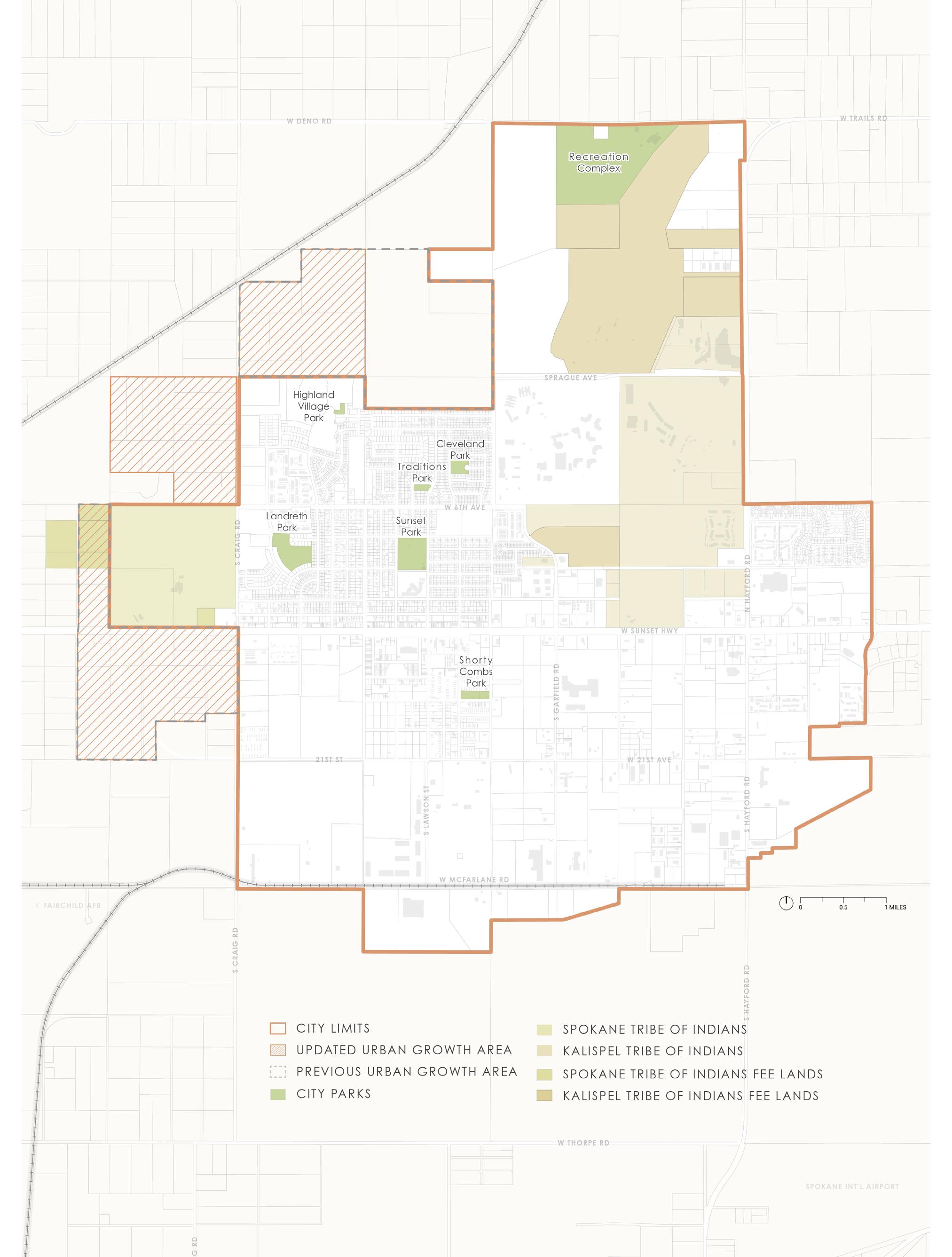
The City has several parks and public facilities such as the Airway Heights Recreation Center, Sunset Park, Shorty Combs Park, and Cleveland Park. The City is considering developing a new City Hall campus in Airway Heights.
Both the Kalispel Tribe of Indians and the Spokane Tribe of Indians have land in the City of Airway Heights, including lands held in trust by the Bureau of Indian Affairs and fee land.
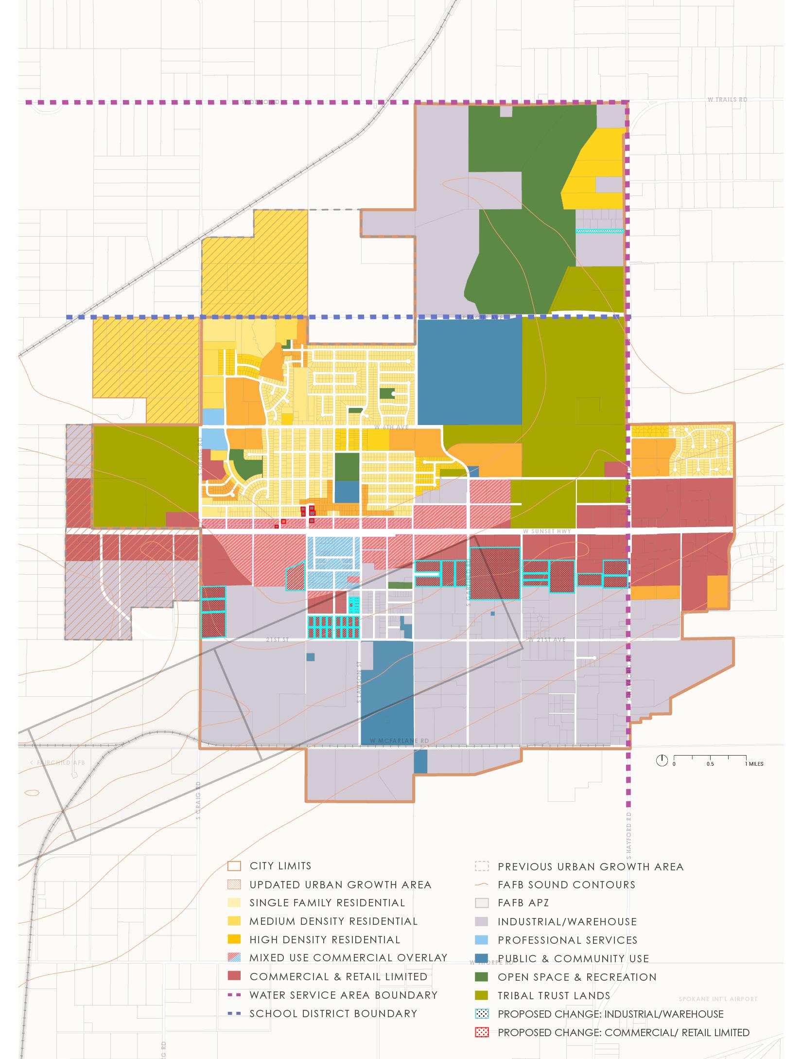
The Comprehensive Plan’s Vision includes 10 big ideas and 12 Goals. Each big idea and goal applies selectively to each element.
Idea 1. Plan for a community where people can a ord to live and work
Idea 2. Plan for a walkable and bikeable community
Idea 3. Plan for full-service neighborhoods with access to goods and services near residential neighborhoods
Idea 4. Implement Plans for the Downtown
Idea 5. Provide more variety in housing types to support a multi-generational and a ordable community
Idea 6. Expand parks, recreation, arts and cultural uses
Idea 7. Monitor growth to understand if the City is accomplishing community goals and priorities
Idea 8. Maintain and expand access to high-quality education in Airway heights
Idea 9. Transform Highway 2 to be attractive and reflect the priorities for Airway Heights
Idea 10. Plan, build, and maintain infrastructure and municipal facilities in the City necessary to support the City’s Comprehensive Plan
G.01 Grow and sustain a balanced, resilient economy for Airway Heights, providing jobs, community prosperity, and fiscal health.
G.02 Maintain and improve the provision of high-quality, affordable, and efficient community services in Airway Heights.
G.03 Maintain and improve Airway Heights’ small-town scale, unique civic identity, and aesthetic beauty.
G.04 Develop the historic city center as the “heart” of Airway Heights, enhancing its commercial, service, and civic vitality.
G.05 Support provision of diverse housing types in Airway Heights, serving all residents and keeping neighborhoods safe, vital, and attractive.
G.06 Maintain and improve Airway Heights’ transportation network, on pace and in concert with needs including traffic flow, land use character, and community value.
G.07 Plan for and establish types and quantities of land uses in Airway Heights that support community needs, and promote service efficiency, and fiscal sustainability.
G.08 Protect and maintain Airway Heights’ natural resources including clean air, soils, wetlands and ground water, and minimize light and noise pollution citywide.
G.09 Maintain and improve Airway Heights’ parks and recreational opportunities, sustaining an attractive, safe, and functional system for all, with every home located within the service area of a park.
G.10 Sustain and expand Airway Heights’ arts, cultural, and civic environment.
G.11 Maintain the City of Airway Heights’ long-term fiscal health.
G.12 Involve the community of Airway Heights in all local government planning and decision-making, helping develop and implement plans for the city’s future.
P.01
Support land use patterns that:
• Maintain or enhance community levels of service.
• Foster the long-term fiscal health of the community.
• Maintain and enhance resident quality of life.
• Promote compatible, well-designed development.
• Implement goals and policies of the comprehensive plan, related master plan and/or facility plans.
• Are compatible with FAFB and airport overlay areas.
• Support a walkable and bikeable City.
• Provide a range of housing types and options.
• Support living wage employment opportunities for its residents.
• Encourage travel demand reduction through use of mixed-use residential, commercial, and institutional development.
• Advance multimodal facilities to reduce reliance on single-occupancy vehicles.
• Promote connectivity between developments.
P.02
Apply or revise zoning designations with careful consideration of factors including:
• Future land use mapping.
• Compatibility with surrounding land uses.
• Restrictions in FAFB and airport overlay areas.
• Infrastructure and service plans.
• Existing and future traffic patterns are supported through a street network classified by function that enforces multimodal design standards on the City and private development.
• Goals and policies of the Comprehensive Plan, related Master Plan, and/or Facility Plans.
• Housing needs and affordability for all income ranges.
• Economic development and implementation of the Downtown Plan.
• Implementation of the Industrial Sub-Area Plan.
P.03
Maintain concurrency between the Comprehensive Plan Land Use Element and available funding, ensuring efficient and timely levels of service (LOS) provision.
To maintain mobility that allows for existing vehicle movements while balancing the need to support traffic growth within a developing community, the City will maintain a concurrency/LOS mobility standard consistent with those proscribed by Airway Heights Traffic Impact Study Standard Guidelines, and required through Airway Height Municipal Code 14.09 for Transportation Concurrency.
P.04 Ensure identification and siting of essential public facilities (EPFs) comply with state criteria, including RCW 36.70A.200, RCW 71.09.020(14), Office of Financial Management (OFM) EPF listings, and Countywide Planning Policies for Spokane County.
P.05 Encourage development patterns that provide suitably-scaled, daily needs services within ¼ mile of residential areas, allowing a measure of independence for those who cannot or choose not to drive.
Strategy
• Identify small-scale neighborhood commercial sites that are suitable to service existing and planned residential development. These should be located along transit corridors.
• Ensure access to STA transit access is within ¼-mile of multifamily and large-scale single-family residential centers.
• Ensure access to parks within the 10 minute or ¼ mile of residential areas.
• Promote connectivity between developments.
Action
• Rezone areas suitable for neighborhood commercial development following public outreach engagement.
• Assess, plan, and implement multi-modal transportation needs for neighborhood commercial areas.
• Promote the development of park spaces, including pocket parks, trails, multi-use paths, and more.
P.06 Plan for compact, pedestrian-oriented development patterns in neighborhoods and commercial areas.
Strategy
• Develop and maintain design standards for pedestrian-oriented environment.
• Ensure access to STA transit within ¼-mile of multifamily and large-scale single-family residential centers.
• Promote the integration of pedestrian-friendly designs into subdivisions, incorporating features such as landscape boulevards, buffers, street art, “pocket” parks, traffic control measures, and pedestrian/bicycle infrastructure, such as benches and bike racks.
• Require private developments to conduct bicycle and pedestrian analyses, along with traffic impact analyses, as determined by the City engineer during scope sessions.
• Enforce Multimodal Level of Service (LOS) goals for private development, incentivizing compliance by offering reductions in the City traffic impact fee for meeting these standards. (See Transportation Section for multimodal LOS standards/definition.)
Action
• Develop new pedestrian-oriented design standards that will support missing middle housing development and human-scaled neighborhood design with an emphasis on ground-related housing.
• Initiate discussions with SR 2 commercial owners regarding signs and design standards (including street trees) and the need for public intervention in the rejuvenation of SR 2.
• Develop design guidelines for commercial development on SR 2 which is pedestrian friendly, encourages a grouping of like activities, and is architecturally consistent.
P.07 Require, when possible, traditional residential development patterns, typically featuring:
• Housing that faces the street edge.
• Utilization of alleys for parking and service access.
• An interconnected grid or small-block street network of 300~350-foot-long blocks.
• Extension of the arterial and grid street network applied to all development.
• Cul-de-sac and curvilinear street patterns should be limited.
• Street sections designed for safety, traffic calming, and aesthetic appeal, including narrower lanes, sidewalks, bike facilities, landscaping, and lighting.
Strategy
• Review the development code and best practices to identify updates to the development standards to reinforce traditional residential development patterns.
Action
• Update development standards in the zoning code to implement traditional residential development patterns.
• Update the public works standards to require connections by development to the existing street network and extend the grid street network into undeveloped and urban growth areas.
P.08
Encourage compatible infill development and redevelopment of vacant and under-utilized properties within City limits, ensuring compatibility with FAFB and airport overlay areas.
Strategy
• Review the development code and best practices to identify infill development standards including lot sizes, access to the roadway and utilities, and design standards for housing for missing middle and highdensity housing consistent with the Downtown Plan.
Action
• Update development standards in the zoning code to implement smalllot development standards and redevelopment in high-density areas consistent with the Downtown Plan.
• Develop a Geographic Information System (GIS) inventory and a Capital Improvement Program (CIP) or Transportation Improvement Program (TIP) strategy to address the infill of missing sidewalks along undeveloped sites, ensuring enhanced pedestrian and bicycle mobility and safety.
P.09
Prioritize location of schools in areas with:
• Access to arterial and collector streets.
• Ample sidewalks, bike, and pedestrian access.
• Proximity to residential areas being served.
• Cost-effective access to necessary utilities and services.
• Locations with multiple street access.
P.10
Prioritize location of new industrial development in areas that provide:
• Close proximity to major transportation corridors including in the industrial sub-area and along 21st Avenue.
• Siting near existing industrial uses, where possible.
• Cost-effective access to utilities and services.
• Access to transit to reduce employee vehicle trips.
• Paved roadway access to arterials.
• Ability to minimize trucking through residential areas.
Ensure new industrial uses near residential areas do not create noise, odor, air, or visual pollution beyond that normally associated with residential uses.
P.12 With Spokane County and service providers, coordinate development patterns and the transportation network in Airway Heights’ Urban Growth Area (UGA), helping prevent adverse consequences for future incorporation.
Strategy
• Prohibit UGA (Urban Growth Area) boundary adjustments that impose excessive burdens on Airway Heights citizens for extending utilities or transportation infrastructure.
• Require adjacent agencies or private developments to conduct infrastructure needs assessments for land development projects seeking incorporation into the Airway Heights UGA, ensuring the identification and acceptance by City officials of adequate utility or transportation mitigations before incorporating new development.
P.13 Ensure that adequate land is available for future housing needs, helping serve residents of all ages, incomes, and abilities through provision of diverse housing types and price levels.
Strategy
• Monitor land availability and build out results for housing developments to ensure housing goals are being accomplished.
Action
• Initiate urban growth area modifications as needed to address housing. Annex urban growth areas as needed and able to be served.
P.16 Encourage housing developments to front on streets or open space and promote clustering of units in new residential development to enhance service efficiencies and create opportunities for shared open space, landscaping, and creative approaches to shared parking solutions.
P.17 Ensure regulations apply equally to site-built and manufactured housing types.
P.18 Consider location of multi-family development in areas that:
• Can be integrated into existing neighborhood development patterns, ensuring compatibility in building scale and neighborhood character, replicating neighborhood design elements, and supporting a pedestrianfriendly environment. Examples include: limiting number of units in buildings limiting the building height to 1-2 stories requiring buildings to be along street frontages, creating a clear entrance and space related to the street requiring differing building forms built on a neighborhood block scale such as mixes of duplex, triplex, fourplex, courtyard apartments, townhomes and cluster housing.
• Can be designed to minimize large surface parking lots and promote shared parking, requiring parking on the interior of the site, behind buildings.
• Provide a transition between higher- and lower-intensity development patterns.
• Are appropriate and compatible with existing land uses.
• Are part of projects involving mixed-use or master-planned areas.
• Have convenient access to STA transit via use of pedestrian and/or bike accommodations (i.e. sidewalk, pathways, bike lanes, etc.)
• Have access to a collector or arterial .
• Do not concentrate multifamily developments in an area of the city, but rather distributes them throughout the community to avoid concentrations.
Coordinate all long-range community planning objectives with Fairchild Air Force Base (FAFB), minimizing or eliminating operational or land use conflicts.
P.36 Guide annexation decisions by and considering:
• Master plans for water, sewer, transportation, parks, and emergency services.
• Provision of necessary rights-of-way and easements.
• Studies that evaluate environmental and public service factors.
• Timing that supports orderly development and/or coordinated extension of public services.
• Comprehensive Plan goals and policies.
P.40 With Spokane County, base determination of Urban Growth Area (UGA) limits considering:
• Land use forecast and demands.
• Future service capabilities.
• Infrastructure planning.
• Ground and surface water provision and quality.
• Protection of public health.
• Transportation impacts.
P.42 Protect the appearance and natural functions of critical areas in Airway Heights, using best available science (BAS) to protect functions and values, developing criteria including grading, setback, and vegetation disturbance.
P.44 Provide storm water collection and treatment through use of landscaped infiltration areas and encourage the use of new or improved technology whenever practical.
P.46
Update regulations to enable a broader range of housing opportunities.
Action
• Revise development regulations to expand the types of housing that are permitted in the residential zones with a focus on “missing middle” housing such as accessory dwelling units, townhouses, cottage housing, courtyard apartments, triplexes, and fourplexes.
• Combine the low- and medium-density land use categories to provide for a greater variety of housing opportunities.
• Actively mix housing and commercial uses in and near the Downtown as depicted in the Downtown Plan to provide higher quality, lower cost housing.
• Reduce parking requirements for mixed-uses, especially those designed to serve low-income or senior citizen residents.
• Eliminate redundant and unnecessary requirements for development regulations and standards.
• Review existing and proposed building and development regulations, standards, and permitting processes to increase regulatory efficiency.
In the Downtown, integrate a mixture of housing options including affordable and “missing middle” housing.
Strategy:
• Promote new development concepts in housing, retail, restaurants, and the arts, such as mixed-use development, incubators, maker spaces, and other lower-cost start-up spaces for local entrepreneurs.
• Actively pursue housing developments within the downtown subarea and along US-2 that support “missing middle” markets such as young professionals, first-time homebuyers, and downsizing households.
• Ensure land use designations, zoning, subdivision, and development standards are supportive of mixed housing and downtown redevelopment.
• Evaluate the feasibility for a mixed-use housing pilot project.
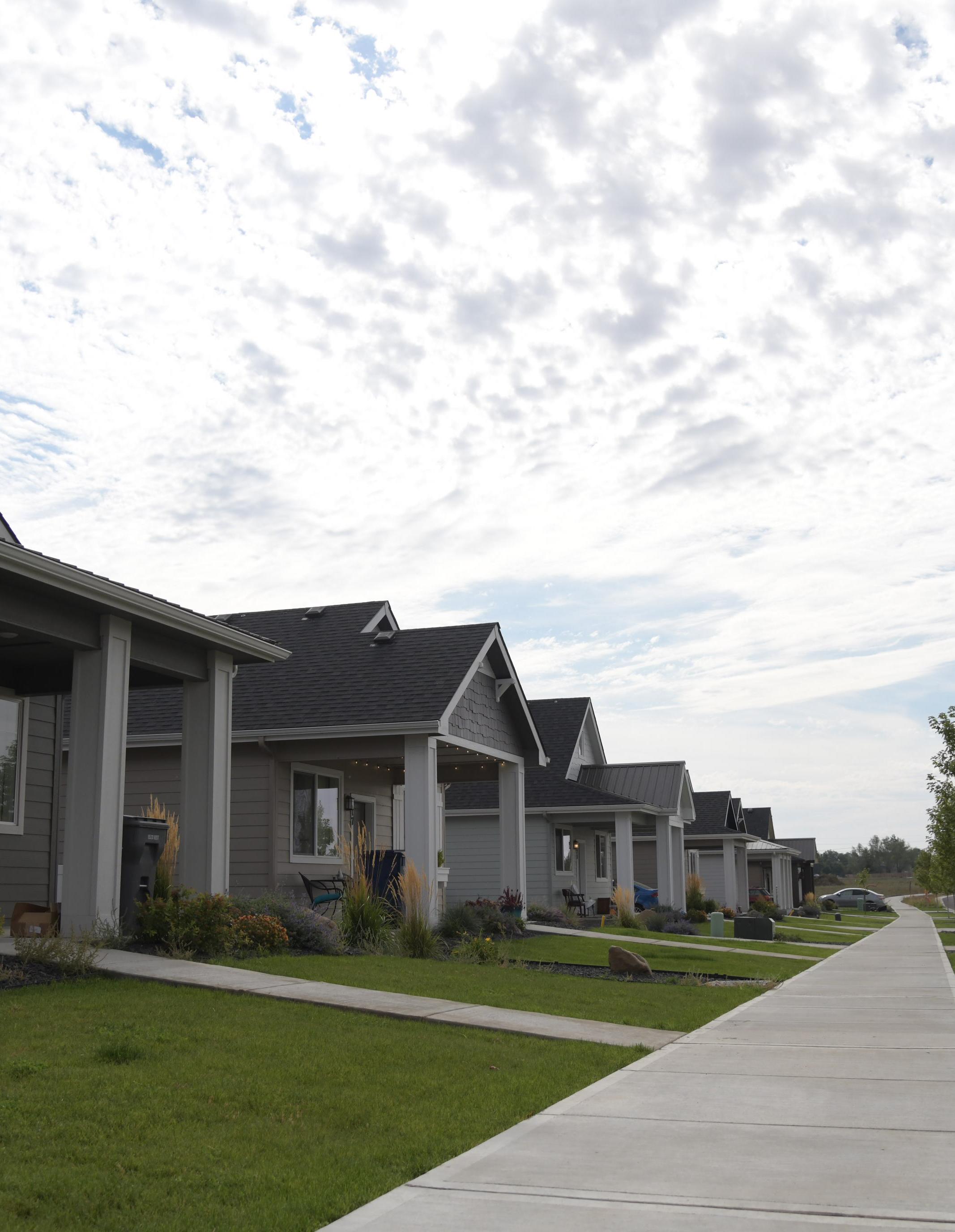
The purpose of this chapter is to identify and aid provision of housing in Airway Heights according to type, location, and quantity to serve projected needs. Of course, housing carries greater potential than simple provision of shelter. Attractive, affordable, suitable, and safe housing is a vital ingredient to the success of any community. The Washington State Growth Management Act (GMA) recognizes this, as reflected in the following GMA goal for housing that was updated in 2022:
“Plan for and accommodate housing affordable to all economic segments of the population of this state, promote a variety of residential densities and housing types, and encourage preservation of existing housing stock.”
Accordingly, a key objective for Airway Heights is to support the provision of housing as coordinated with a broad range of goals and policies unique to the city, in addition to those required by the GMA. These housing-related goals and policies are provided at the end of this chapter, showing how the City intends to meet its requirements as well as advance its long-term vision. A brief analysis of today’s housing supply, growth trend, and land use alternatives are provided in Volume II.
Policies in this chapter were developed in view of data that showcase existing and forecasted conditions likely to emerge over a 20-year horizon. Topics considered include population counts and projections, household characteristics, unit types, available land quantities, and more. Material published elsewhere in the Comprehensive Plan may at times be referenced, helping minimize overlap and the overall size of the Plan.
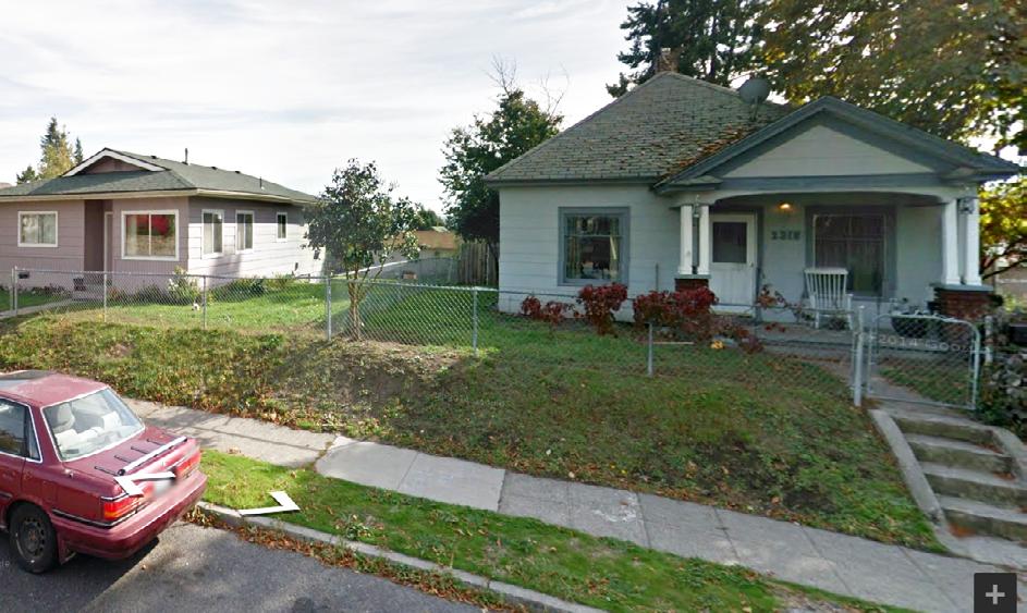
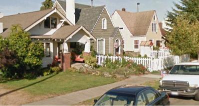
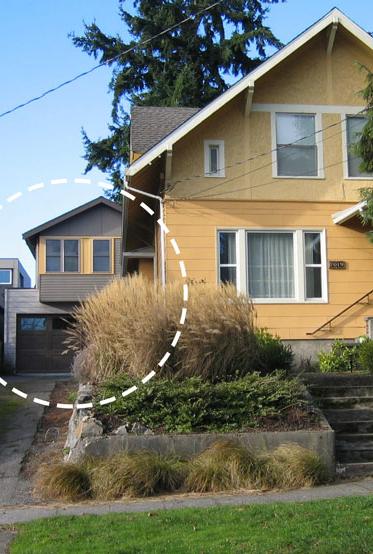
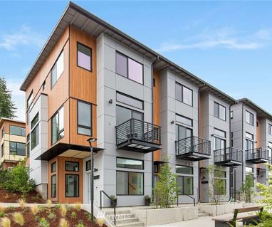
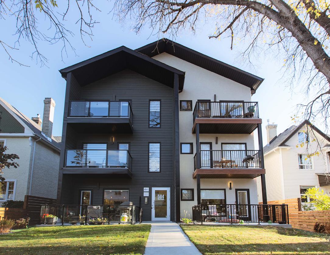
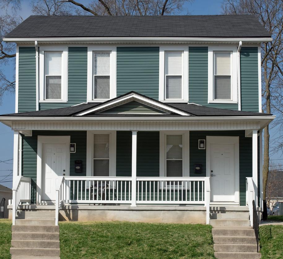
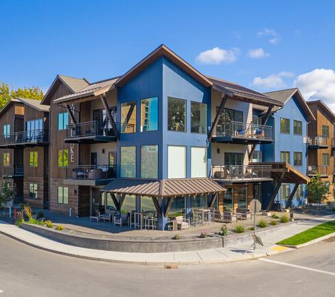
Housing density, as described in this chapter, is defined as below. The photos on the following pages depict examples of various housing typologies and densities.
• Low density: Up to 5 units per acre
• Medium density: Up to 10 units per acre
• High density: 10 to 20 units per acre
• Mixed-use density: 10 to 20 units per acre

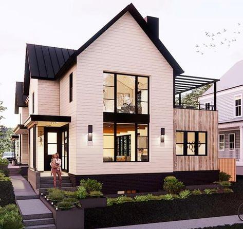

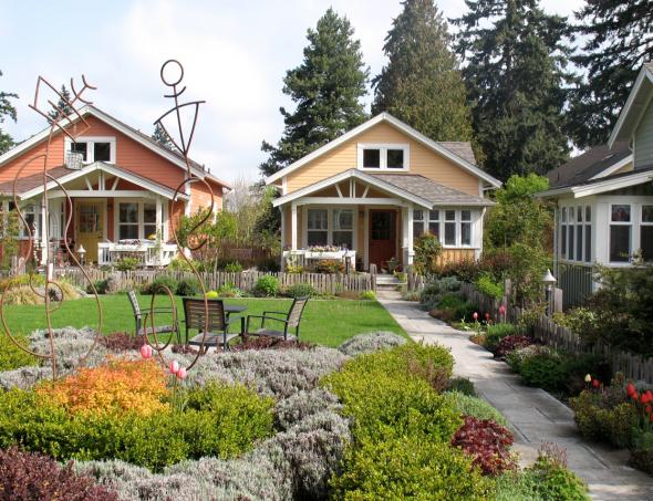
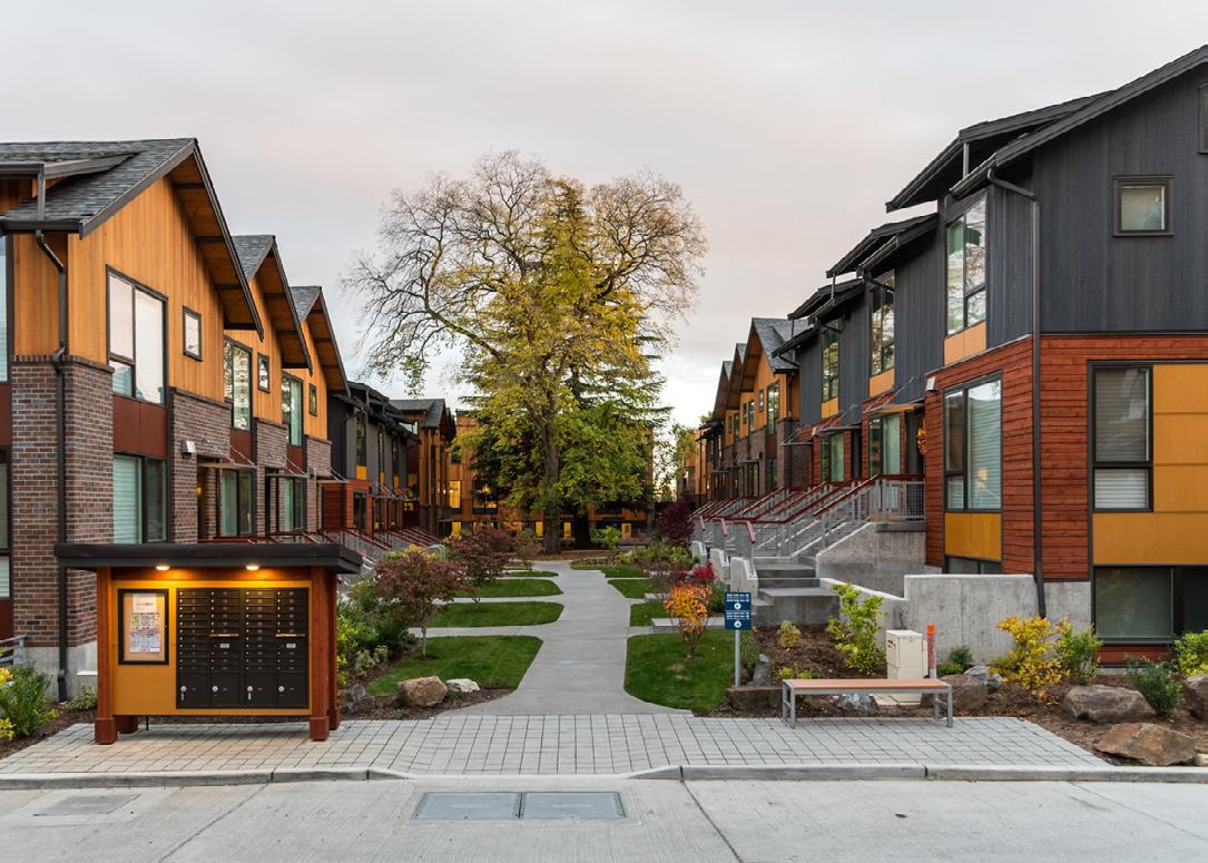


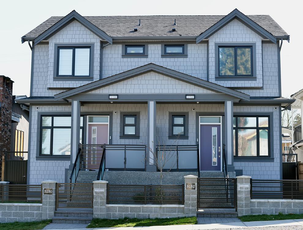





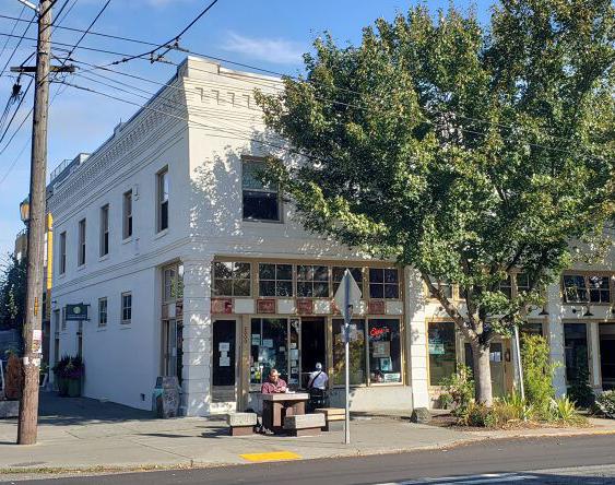
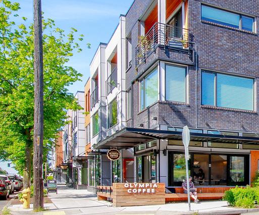
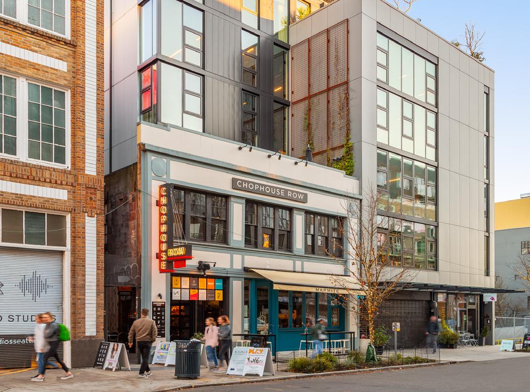
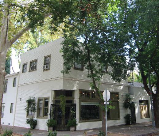

The Comprehensive Plan’s Vision includes 10 big ideas and 12 Goals. Each big idea and goal applies selectively to each element.
Idea 1. Plan for a community where people can a ord to live and work
Idea 2. Plan for a walkable and bikeable community
Idea 3. Plan for full-service neighborhoods with access to goods and services near residential neighborhoods
Idea 4. Implement Plans for the Downtown
Idea 5. Provide more variety in housing types to support a multi-generational and a ordable community
Idea 6. Expand parks, recreation, arts and cultural uses
Idea 7. Monitor growth to understand if the City is accomplishing community goals and priorities
Idea 8. Maintain and expand access to high-quality education in Airway heights
Idea 9. Transform Highway 2 to be attractive and reflect the priorities for Airway Heights
Idea 10. Plan, build, and maintain infrastructure and municipal facilities in the City necessary to support the City’s Comprehensive Plan
G.01 Grow and sustain a balanced, resilient economy for Airway Heights, providing jobs, community prosperity, and fiscal health.
G.02 Maintain and improve the provision of high-quality, affordable, and efficient community services in Airway Heights.
G.03 Maintain and improve Airway Heights’ small-town scale, unique civic identity, and aesthetic beauty.
G.04 Develop the historic city center as the “heart” of Airway Heights, enhancing its commercial, service, and civic vitality.
G.05 Support provision of diverse housing types in Airway Heights, serving all residents and keeping neighborhoods safe, vital, and attractive.
G.06 Maintain and improve Airway Heights’ transportation network, on pace and in concert with needs including traffic flow, land use character and community value.
G.07 Plan for and establish types and quantities of land uses in Airway Heights that support community needs, and promote service efficiency, and fiscal sustainability.
G.08 Protect and maintain Airway Heights’ natural resources including clean air, soils, wetlands and ground water, and minimize light and noise pollution citywide.
G.09 Maintain and improve Airway Heights’ parks and recreational opportunities, sustaining an attractive, safe, and functional system for all, with every home located within the service area of a park.
G.10 Sustain and expand Airway Heights’ arts, cultural, and civic environment.
G.11 Maintain the City of Airway Heights’ long-term fiscal health.
G.12 Involve the community of Airway Heights in all local government planning and decision-making, helping develop and implement plans for the city’s future.
P.01 Support land use patterns that:
• Maintain or enhance community levels of service.
• Foster the long-term fiscal health of the community.
• Maintain and enhance resident quality of life.
• Promote compatible, well-designed development.
• Implement goals and policies of the comprehensive plan, related master plan and/or facility plans.
• Are compatible with FAFB and airport overlay areas.
• Support a walkable and bikeable City.
• Provide a range of housing types and options.
• Support living wage employment opportunities for its residents.
• Encourage travel demand reduction through use of mixed-use residential, commercial, and institutional development.
• Advance multimodal facilities to reduce reliance on single-occupancy vehicles.
• Promote connectivity between developments.
P.02
Apply or revise zoning designations with careful consideration of factors including:
• Future land use mapping.
• Compatibility with surrounding land uses.
• Restrictions in FAFB and airport overlay areas.
• Infrastructure and service plans.
• Existing and future traffic patterns are supported through a street network classified by function that enforces multimodal design standards on the City and private development.
• Goals and policies of the Comprehensive Plan, related Master Plan, and/or Facility Plans.
• Housing needs and affordability for all income ranges.
• Economic development and implementation of the Downtown Plan.
• Implementation of the Industrial Sub-Area Plan.
P.05
Encourage development patterns that provide suitably-scaled, daily needs services within ¼ mile of residential areas, allowing a measure of independence for those who cannot or choose not to drive.
Strategy
• Identify small-scale neighborhood commercial sites that are suitable to service existing and planned residential development. These should be located along transit corridors.
• Ensure access to STA transit access is within ¼-mile of multifamily and large-scale single-family residential centers.
• Ensure access to parks within the 10 minute or ¼ mile of residential areas.
• Promote connectivity between developments.
Action
• Rezone areas suitable for neighborhood commercial development following public outreach engagement.
• Assess, plan, and implement multi-modal transportation needs for neighborhood commercial areas.
• Promote the development of park spaces, including pocket parks, trails, multi-use paths, and more.
P.06
Plan for compact, pedestrian-oriented development patterns in neighborhoods and commercial areas.
Strategy
• Develop and maintain design standards for pedestrian-oriented environment.
• Ensure access to STA transit within ¼-mile of multifamily and large-scale single-family residential centers.
• Promote the integration of pedestrian-friendly designs into subdivisions, incorporating features such as landscape boulevards, buffers, street art, “pocket” parks, traffic control measures, and pedestrian/bicycle infrastructure, such as benches and bike racks.
• Require private developments to conduct bicycle and pedestrian analyses, along with traffic impact analyses, as determined by the City engineer during scope sessions.
• Enforce Multimodal Level of Service (LOS) goals for private development, incentivizing compliance by offering reductions in the City traffic impact fee for meeting these standards. (See Transportation Section for multimodal LOS standards/definition.)
Action
• Develop new pedestrian-oriented design standards that will support missing middle housing development and human-scaled neighborhood design with an emphasis on ground-related housing.
• Initiate discussions with SR 2 commercial owners regarding signs and design standards (including street trees) and the need for public intervention in the rejuvenation of SR 2.
• Develop design guidelines for commercial development on SR 2 which is pedestrian friendly, encourages a grouping of like activities, and is architecturally consistent.
P.08
Require, when possible, traditional residential development patterns, typically featuring:
• Housing that faces the street edge.
• Utilization of alleys for parking and service access.
• An interconnected grid or small-block street network of 300~350-foot-long blocks.
• Extension of the arterial and grid street network applied to all development.
• Cul-de-sac and curvilinear street patterns should be limited.
• Street sections designed for safety, traffic calming, and aesthetic appeal, including narrower lanes, sidewalks, bike facilities, landscaping, and lighting.
Strategy
• Review the development code and best practices to identify updates to the development standards to reinforce traditional residential development patterns.
Action
• Update development standards in the zoning code to implement traditional residential development patterns.
• Update the public works standards to require connections by development to the existing street network and extend the grid street network into undeveloped and urban growth areas.
Encourage compatible infill development and redevelopment of vacant and under-utilized properties within City limits, ensuring compatibility with FAFB and airport overlay areas.
Strategy
• Review the development code and best practices to identify infill development standards including lot sizes, access to the roadway and utilities, and design standards for housing for missing middle and highdensity housing consistent with the Downtown Plan.
Action
• Update development standards in the zoning code to implement smalllot development standards and redevelopment in high-density areas consistent with the Downtown Plan.
• Develop a Geographic Information System (GIS) inventory and a Capital Improvement Program (CIP) or Transportation Improvement Program (TIP) strategy to address the infill of missing sidewalks along undeveloped sites, ensuring enhanced pedestrian and bicycle mobility and safety.
P.09
Prioritize location of schools in areas with:
• Access to arterial and collector streets.
• Ample sidewalks, bike, and pedestrian access.
• Proximity to residential areas being served.
• Cost-effective access to necessary utilities and services.
• Locations with multiple street access.
P.10
Prioritize location of new industrial development in areas that provide:
• Close proximity to major transportation corridors including in the industrial sub-area and along 21st Avenue.
• Siting near existing industrial uses, where possible.
• Cost-effective access to utilities and services.
• Access to transit to reduce employee vehicle trips.
• Paved roadway access to arterials.
• Ability to minimize trucking through residential areas.
P.11
P.13
Ensure new industrial uses near residential areas do not create noise, odor, air, or visual pollution beyond that normally associated with residential uses.
Ensure that adequate land is available for future housing needs, helping serve residents of all ages, incomes, and abilities through provision of diverse housing types and price levels.
Strategy
• Monitor land availability and build out results for housing developments to ensure housing goals are being accomplished. Action
• Initiate urban growth area modifications as needed to address housing. Annex urban growth areas as needed and able to be served.
P.16
Encourage housing developments to front on streets or open space and promote clustering of units in new residential development to enhance service efficiencies and create opportunities for shared open space, landscaping, and creative approaches to shared parking solutions.
Ensure regulations apply equally to site-built and manufactured housing types.
P.18
Consider location of multi-family development in areas that:
• Can be integrated into existing neighborhood development patterns, ensuring compatibility in building scale and neighborhood character, replicating neighborhood design elements, and supporting a pedestrianfriendly environment. Examples include: limiting number of units in buildings limiting the building height to 1-2 stories requiring buildings to be along street frontages, creating a clear entrance and space related to the street requiring differing building forms built on a neighborhood block scale such as mixes of duplex, triplex, fourplex, courtyard apartments, townhomes and cluster housing.
• Can be designed to minimize large surface parking lots and promote shared parking, requiring parking on the interior of the site, behind buildings.
• Provide a transition between higher- and lower-intensity development patterns.
• Are appropriate and compatible with existing land uses.
• Are part of projects involving mixed-use or master-planned areas.
• Have convenient access to STA transit via use of pedestrian and/or bike accommodations (i.e. sidewalk, pathways, bike lanes, etc.)
• Have access to a collector or arterial .
• Do not concentrate multifamily developments in an area of the city, but rather distributes them throughout the community to avoid concentrations.
P.20
Develop and enhance a transportation system in Airway Heights that:
• Facilitates the safe, efficient movement of people, goods, and services.
• Supports non-motorized and recreational needs.
• Supports land use objectives.
• Promotes livable neighborhoods.
• Increases access to and encourages the use of public transit.
• Improves safe pedestrian and bike routes to schools, housing, employment areas, and between communities.
• Encourages completion of the street grid and improved alley access for development of low density, medium density, and infill housing.
• Provides a residential grid network that ensures multimodal mobility between developments, recreation, services, and schools along City collectors and arterials.
• Implements sound access management techniques by providing connectivity between contiguous commercial developments off the street system.
P.45 Develop partnerships and financial incentives to encourage a variety of housing developments. Action
• Identify possible pilot housing projects for public/private partnerships.
• Coordinate with business and housing agencies to site special needs housing close to relevant business.
• Facilitate business and housing agency collaboration to promote economic development and meet diverse housing needs.
• Coordinate with housing nonprofits for development incentives.
• Coordinate with Fairchild Air Force Base and others for funding or other support to make relocation attractive to residents from the Accident Potential Zone II (APZ).
• Consider density bonuses, financial methods, and design standards to encourage mixed-use housing.
P.46
P.70
Update regulations to enable a broader range of housing opportunities. Action
• Revise development regulations to expand the types of housing that are permitted in the residential zones with a focus on “missing middle” housing such as accessory dwelling units, townhouses, cottage housing, courtyard apartments, triplexes, and fourplexes.
• Combine the low- and medium-density land use categories to provide for a greater variety of housing opportunities.
• Actively mix housing and commercial uses in and near the Downtown as depicted in the Downtown Plan to provide higher quality, lower cost housing.
• Reduce parking requirements for mixed-uses, especially those designed to serve low-income or senior citizen residents.
• Eliminate redundant and unnecessary requirements for development regulations and standards.
• Review existing and proposed building and development regulations, standards, and permitting processes to increase regulatory efficiency.
In the Downtown, integrate a mixture of housing options including affordable and “missing middle” housing.
Strategy:
• Promote new development concepts in housing, retail, restaurants, and the arts, such as mixed-use development, incubators, maker spaces, and other lower-cost start-up spaces for local entrepreneurs.
• Actively pursue housing developments within the downtown subarea and along US-2 that support “missing middle” markets such as young professionals, first-time homebuyers, and downsizing households.
• Ensure land use designations, zoning, subdivision, and development standards are supportive of mixed housing and downtown redevelopment.
• Evaluate the feasibility for a mixed-use housing pilot project.

The Parks and Recreation element serves to inform how Airway Heights acquires, designs, manages, and programs its park system. As with other facilities and services that the City provides, parks and recreation planning must take place to advance community goals and account for population growth. Adequate land must be set aside for these purposes, and capital funds must be secured to develop and maintain the facilities.
The goals and policies in this chapter are meant to reflect the community’s needs and priorities for recreation planning, and to coordinate these objectives with other planning considerations. The goals are informed by and are concurrent with the Airway Heights Parks & Recreation Master Plan, which contains more detail on the goals for the park system and the status of individual parks.
In all communities, recreation serves an important function for residents and visitors alike, providing places for exercise, sports, children’s play, relaxation, and community gatherings. Parks and recreation areas also enhance the aesthetic quality of the city, adding value to surrounding neighborhoods and commercial areas. Depending on their design, parks can also provide habitat for local wildlife and perform ecosystem services such as stormwater filtration, soil stabilization, and urban heat mitigation.
Where we site our parks, what we put in them, and how we program them affects who is able to use them, how they affect the environment, and the overall impact they have on the character of the neighborhood. For this reason, this document aims to shape the design and planning of Airway Heights parks such that they benefit the whole community for years to come.

The Comprehensive Plan’s Vision includes 10 big ideas and 12 Goals. Each big idea and goal applies selectively to each element.
Idea 1. Plan for a community where people can a ord to live and work
Idea 2. Plan for a walkable and bikeable community
Idea 3. Plan for full-service neighborhoods with access to goods and services near residential neighborhoods
Idea 4. Implement Plans for the Downtown
Idea 5. Provide more variety in housing types to support a multi-generational and a ordable community
Idea 6. Expand parks, recreation, arts and cultural uses
Idea 7. Monitor growth to understand if the City is accomplishing community goals and priorities
Idea 8. Maintain and expand access to high-quality education in Airway heights
Idea 9. Transform Highway 2 to be attractive and reflect the priorities for Airway Heights
Idea 10. Plan, build, and maintain infrastructure and municipal facilities in the City necessary to support the City’s Comprehensive Plan
G.01 Grow and sustain a balanced, resilient economy for Airway Heights, providing jobs, community prosperity, and fiscal health.
G.02 Maintain and improve the provision of high-quality, affordable, and efficient community services in Airway Heights.
G.03 Maintain and improve Airway Heights’ small-town scale, unique civic identity, and aesthetic beauty.
G.04 Develop the historic city center as the “heart” of Airway Heights, enhancing its commercial, service, and civic vitality.
G.05 Support provision of diverse housing types in Airway Heights, serving all residents and keeping neighborhoods safe, vital, and attractive.
G.06 Maintain and improve Airway Heights’ transportation network, on pace and in concert with needs including traffic flow, land use character, and community value.
G.07 Plan for and establish types and quantities of land uses in Airway Heights that support community needs, and promote service efficiency, and fiscal sustainability.
G.08 Protect and maintain Airway Heights’ natural resources including clean air, soils, wetlands and ground water, and minimize light and noise pollution citywide.
G.09 Maintain and improve Airway Heights’ parks and recreational opportunities, sustaining an attractive, safe, and functional system for all, with every home located within the service area of a park.
G.10 Sustain and expand Airway Heights’ arts, cultural, and civic environment.
G.11 Maintain the City of Airway Heights’ long-term fiscal health.
G.12 Involve the community of Airway Heights in all local government planning and decision-making, helping develop and implement plans for the city’s future.
Airway Heights currently has six developed parks, with an additional park in development. These parks span a total of 33.11 acres and provide various facilities, including sports courts and fields, playgrounds, open lawn areas, a skate park, and a splash pad. According to responses to surveys conducted from January 2020 to June 2021, the parks with the highest use are Sunset Park and Airway Heights Recreation Center.
The Airway Heights Recreation Complex and Recreation Center is the largest park property in the city, totaling 70 acres. Ten acres have been developed as part of Phase1, including the Recreation Center, which offers indoor recreation amenities such as a gymnasium, pools, and weight training areas. As subsequent development phases proceed, these acres will be added to the park system and accounted for in the Level of Service calculation.
Park acreage is currently the metric for determining Level of Service (LOS) for the park system, and Airway Heights uses a standard of 10 acres per 1000 residents as its goal post. Under this metric, the deficit in park acreage will amount to over 100 acres by 2042 if no new park land is acquired or developed. If Airway Heights Recreation Complex and Recreation Center proceeds with development, the deficit will be closer to 86 acres.
While acreage is a straightforward way to calculate Level of Service, it does not account for park accessibility or programming. These factors should be considered when making decisions about park development.
Ideally, people should be able to walk to a park within half a mile from where they live. Currently, about 50% of Airway Heights survey respondents feel that there are sufficient Parks and green spaces within walking distance from their residence. As described in the Parks Master plan, there are gaps in park service areas, with noticeably fewer parks south of Highway 2. Also, there are no parks located east of Garfield Road, with residential areas situated to the north of US-2. This makes it difficult for residents in these neighborhoods to walk or bike to parks, as the highway acts as a physical barrier.
As the City acquires land, developing parks in areas without a park within half a mile should be a priority.
The way that parks are designed and programmed affects who is able to use them. For example, elderly people may desire benches for rest and shade from the sun. Parks where benches and pathways revolve around children’s playgrounds are primarily used by families. Sports fields and courts are often used for a single sport.
Offering a variety of active and passive use facilities helps to ensure that people find what they need at the park, whether that may be sports fields for playing, trees and gardens to connect with nature, or shade structures and picnic tables for community gathering. Open lawn and paved plazas are “flexible spaces” that can be used for everything from outdoor markets, yoga, roller skating, frisbee, art classes, or picnics. In many cases, it is helpful to work with local groups to help program these spaces, because they will be most actively used when they reflect the needs of the community.
More than half the respondents to the above-mentioned survey report a need for paved walking and biking trails and rated it as the most important facility for their household. Other notable needs were park shelters/picnic areas, playground equipment/play areas, and a dog park.

P.01
Support land use patterns that:
• Maintain or enhance community levels of service.
• Foster the long-term fiscal health of the community.
• Maintain and enhance resident quality of life.
• Promote compatible, well-designed development.
• Implement goals and policies of the comprehensive plan, related master plan and/or facility plans.
• Are compatible with FAFB and airport overlay areas.
• Support a walkable and bikeable City.
• Provide a range of housing types and options.
• Support living wage employment opportunities for its residents.
• Encourage travel demand reduction through use of mixed-use residential, commercial, and institutional development.
• Advance multimodal facilities to reduce reliance on single-occupancy vehicles.
• Promote connectivity between developments.
P.02
Apply or revise zoning designations with careful consideration of factors including:
• Future land use mapping.
• Compatibility with surrounding land uses.
• Restrictions in FAFB and airport overlay areas.
• Infrastructure and service plans.
• Existing and future traffic patterns are supported through a street network classified by function that enforces multimodal design standards on the City and private development.
• Goals and policies of the Comprehensive Plan, related Master Plan, and/or Facility Plans.
• Housing needs and affordability for all income ranges.
• Economic development and implementation of the Downtown Plan.
• Implementation of the Industrial Sub-Area Plan.
P.03
P.05
Maintain concurrency between the Comprehensive Plan Land Use Element and available funding, ensuring efficient and timely levels of service (LOS) provision.
To maintain mobility that allows for existing vehicle movements while balancing the need to support traffic growth within a developing community, the City will maintain a concurrency/LOS mobility standard consistent with those proscribed by Airway Heights Traffic Impact Study Standard Guidelines, and required through Airway Height Municipal Code 14.09 for Transportation Concurrency.
Encourage development patterns that provide suitably-scaled, daily needs services within ¼ mile of residential areas, allowing a measure of independence for those who cannot or choose not to drive.
Strategy
• Identify small-scale neighborhood commercial sites that are suitable to service existing and planned residential development. These should be located along transit corridors.
• Ensure access to STA transit access is within ¼-mile of multifamily and large-scale single-family residential centers.
• Ensure access to parks within the 10 minute or ¼ mile of residential areas.
• Promote connectivity between developments.
Action
• Rezone areas suitable for neighborhood commercial development following public outreach engagement.
• Assess, plan, and implement multi-modal transportation needs for neighborhood commercial areas.
• Promote the development of park spaces, including pocket parks, trails, multi-use paths, and more.
P.12
With Spokane County and service providers, coordinate development patterns and the transportation network in Airway Heights’ Urban Growth Area (UGA), helping prevent adverse consequences for future incorporation.
Strategy
• Prohibit UGA (Urban Growth Area) boundary adjustments that impose excessive burdens on Airway Heights citizens for extending utilities or transportation infrastructure.
• Require adjacent agencies or private developments to conduct infrastructure needs assessments for land development projects seeking incorporation into the Airway Heights UGA, ensuring the identification and acceptance by City officials of adequate utility or transportation mitigations before incorporating new development.
P.20
Develop and enhance a transportation system in Airway Heights that:
• Facilitates the safe, efficient movement of people, goods, and services.
• Supports non-motorized and recreational needs.
• Supports land use objectives.
• Promotes livable neighborhoods.
• Increases access to and encourages the use of public transit.
• Improves safe pedestrian and bike routes to schools, housing, employment areas, and between communities.
• Encourages completion of the street grid and improved alley access for development of low density, medium density, and infill housing.
• Provides a residential grid network that ensures multimodal mobility between developments, recreation, services, and schools along City collectors and arterials.
• Implements sound access management techniques by providing connectivity between contiguous commercial developments off the street system.
P.21
P.22
Improve year-round access, safety, utility, convenience and service levels for alternative modes of transportation, including:
• Walking.
• Bicycling.
• Public transit services.
• Rideshare/carpooling.
• Use of boulevards and landscape buffers designed consistent with City Standards that provide for snow storage that keep roads, bike lanes, and sidewalk/paths accessible year-round.
• Development that promotes complete streets, improves access to STA transit, and/or provides shelters/storage for active transportation to improve multimodal LOS.
• Businesses and residential developments that encourage commute trip reduction strategies, which can also improve multimodal LOS.
Maintain and improve the continuity of sidewalks, trails, and bicycle paths in Airway Heights.
Strategy
• Develop and maintain a Master Sidewalk and Pedestrian Network Plan that engineers and planners can use to coordinate the advancement of active transportation facilities.
• Enforce Multimodal Level of Service (LOS) goals for private development, incentivizing compliance by offering reductions in the City traffic impact fee for meeting these standards. (See Transportation Section for multimodal LOS standards/definition.)
P.23
P.29
Work to improve street and trail connectivity and quality in all areas of Airway Heights, improving walkability, public health and safety, and transportation efficiency.
Strategy
• Develop and maintain a Master Sidewalk and Pedestrian Network Plan that engineers and planners can use to coordinate the advancement of active transportation facilities.
• Utilize greenspace, bollards, and safe crossing elements to separate motorized traffic from sidewalks, open spaces, and trails.
• Take action to increase pedestrian safety. New crosswalks with signage, pavement tape, flex delineators, and planters are examples of quick and inexpensive changes that could drastically improve safety.
• Enforce Multimodal Level of Service (LOS) goals for private development, incentivizing compliance by offering reductions in the City traffic impact fee for meeting these standards. (See Transportation Section for multimodal LOS standards/definition.)
Maintain infrastructure and personnel at levels that provide Airway Heights residents with services that are high-quality, effective, and affordable.
Support and cooperate with other agencies and providers of public services to maintain identified Levels of Service (LOS).
Strategy
• Collaborate with adjacent jurisdictions and the Washington State Department of Transportation (WSDOT) to maintain performance and Level of Service (LOS) standards for intersections and roadways. Work to ensure that the LOS needs of these agencies are met for large development projects, including providing potential mitigation for transportation impacts.
P.30
Plan new development to ensure provision of public services at current Levels of Service (LOS) or the LOS identified in City-adopted Master Plans.
Strategy
• Require development projects to demonstrate transportation concurrency by applying the City’s traffic impact analysis standards and process.
• Require development projects to meet the water concurrency requirements as set forth in the Airway Heights Municipal Code (AHMC) chapter 14.
• Enforce Multimodal Level of Service (LOS) goals for private development, incentivizing compliance by offering reductions in the City traffic impact fee for meeting these standards. (See Transportation Section for multimodal LOS standards/definition.)
P.36 Guide annexation decisions by and considering:
• Master plans for water, sewer, transportation, parks, and emergency services.
• Provision of necessary rights-of-way and easements.
• Studies that evaluate environmental and public service factors.
• Timing that supports orderly development and/or coordinated extension of public services.
• Comprehensive Plan goals and policies.
P.43 Promote landscaping guidelines that:
• Protect wildlife habitats by maintaining existing trees and vegetative cover.
• Re-vegetate disturbed areas.
• Beautify streets, roadways, and surface parking lots.
• Help treat and address stormwater issues.
P.49
P.50
Improve the overall community image by creating areas that enhance the sense of civic pride within the City by enhancing the aesthetic qualities of the City through the attractive and memorable design of park and recreation features.
Strategy
• Identify & encourage areas appropriate for civic areas, town/neighborhood squares, & other public open spaces.
• Encourage the establishment of community civic groups dedicated to improving the community’s appearance.
• Identify areas in the community to install public art.
• Invest in streetscape improvements and beautification efforts in downtown to cultivate a stronger identity and sense of place, transforming the streets and sidewalks into the vibrant, lively spaces envisioned by the community.
Provide year-round park and recreation features, facilities, and programs, in sufficient quantity and diversity, to provide opportunities for individuals of all age groups and abilities in order to meet the present and future needs of non-driving residents.
Strategy
• Ensure that every home in the City lies within the service area of a park by pursuing partnerships with developers, by requiring park, trail, and open space dedications with subdivisions according to specified standards, and by actively pursuing funding opportunities from the RCO, Spokane County, and Spokane Parks Foundation.
• Develop both passive and active recreation opportunities on public land including trails, mini exercise and pocket facilities (small scale such as benches and tables).
Action
• Develop a senior and disability recreation plan for inclusive facilities, when possible, at every location.
• Pursue avenues of funding and partnerships with other government agencies, as well as private and non-profit organizations, to develop the remaining 50 acres at the Recreation Complex, including phase 2 of the Recreation Center Expansion and improving year-round recreational opportunities for the region.
P.51 Coordinate with agencies and surrounding communities to develop and broaden the variety of and accessibility to recreation, wellness, and open space opportunities available to city residents of all ages and abilities.
Strategy
• Coordinate with the City of Spokane, Spokane County & surrounding communities to develop and enhance linkages and partnerships to maximize the recreational opportunities for all residents.
• Coordinate with Cheney School District to maximize recreational opportunities at school facilities.
P.52 Ensure park & recreation facilities within the community are of a safe & healthy nature.
Strategy
• Designate & locate park facilities in a manner ensuring compatibility with surrounding uses, especially as new development occurs.
• Provide landscaping, serving to buffer neighboring land uses, and also provide shade and aesthetic amenity for park users.
• Ensure that park sites that are developed in residential neighborhoods are fronted on at least 50% of their perimeter by a public road to allow adequate public access to the site. Ensure visibility into park facilities is maintained from street & other public access areas.
P.74 Require an impact fee, land dedication, or fee in lieu of dedication for community and neighborhood parks based upon the adopted LOS standards set forth in the Park Element.
P.75 Amend existing development regulations to ensure consistency with the neighborhood level of service standards for parks set forth in the Park Element.
P.77 Require all new residential lots or new residential units on lots of record to pay an impact fee, dedicate land, or pay a fee in lieu of land dedication for the development of local parks. The structure of each of these options shall be correlated to the LOS standards set forth in the Parks Element.
P.78 The required dedication of land within a site to be developed as five units or greater of residential development mixed use shall be 10% of the land. The required dedication for land within a singlefamily residential development shall be a minimum of 5% of the land. Dedication lands may not be used for other purposes such as stormwater control, storage or another non-park uses.
This Transportation Element addresses the motorized and non-motorized transportation needs of the City of Airway Heights. It presents the community’s policies regarding projected transportation needs (current and future); locations and conditions of the existing circulation system; the cause, scope, and nature of transportation issues and presents Level of Service Standards, street classifications, and associated transportation problems the City must address regarding projected growth.
As specified in Washington State’s Growth Management Act (GMA), new development is prohibited unless transportation improvements -- or strategies to accommodate such impacts -- are made concurrent with the development. Such improvements and strategies must be in place or financially planned for within six years of development use.
The type and availability of transportation resources are major factors in shaping land use patterns, while conversely, the way land is used strongly influences the need for transportation facilities. For this reason, land use and transportation facilities planning must be closely coordinated. Now and over time, the City intends to correlate existing uses, future uses, and desired characteristics with its transportation planning.


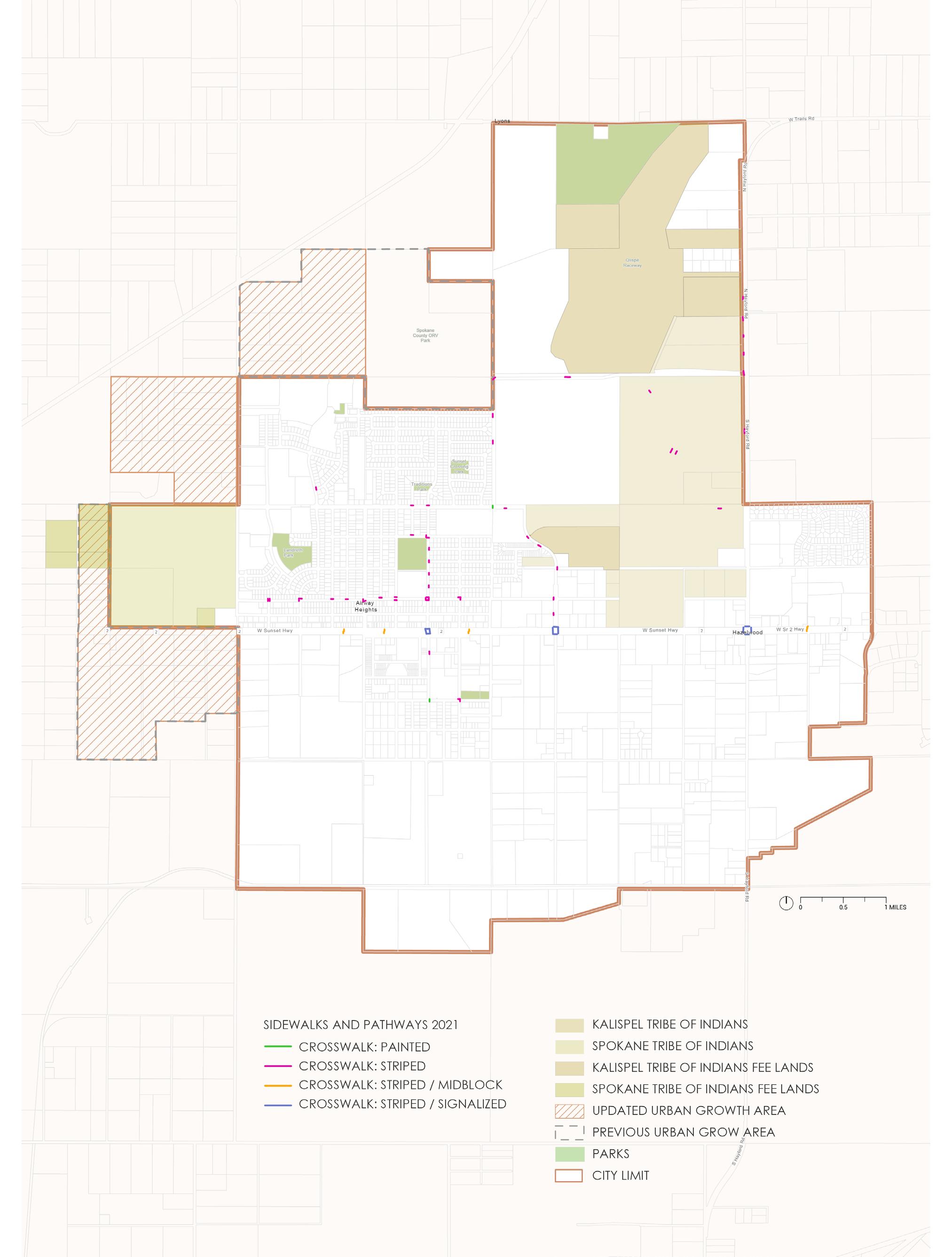
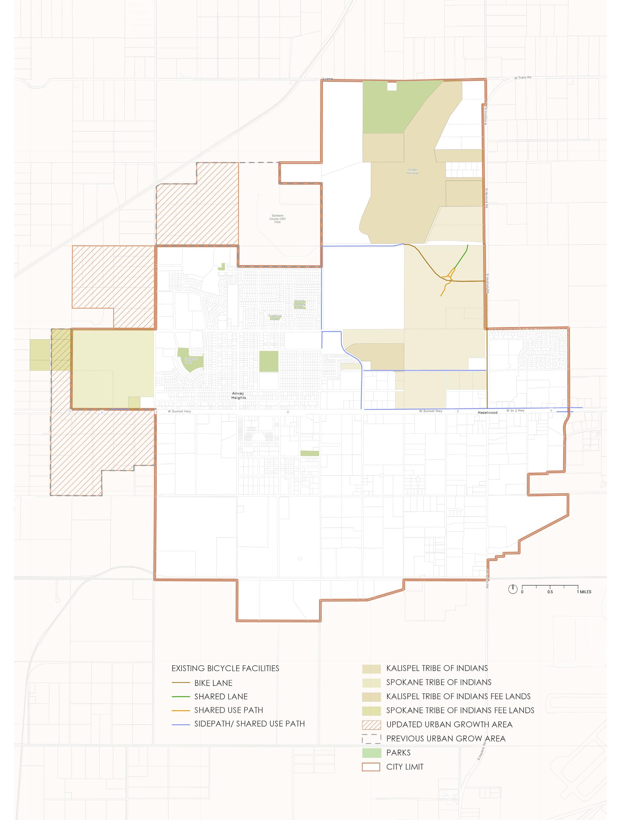
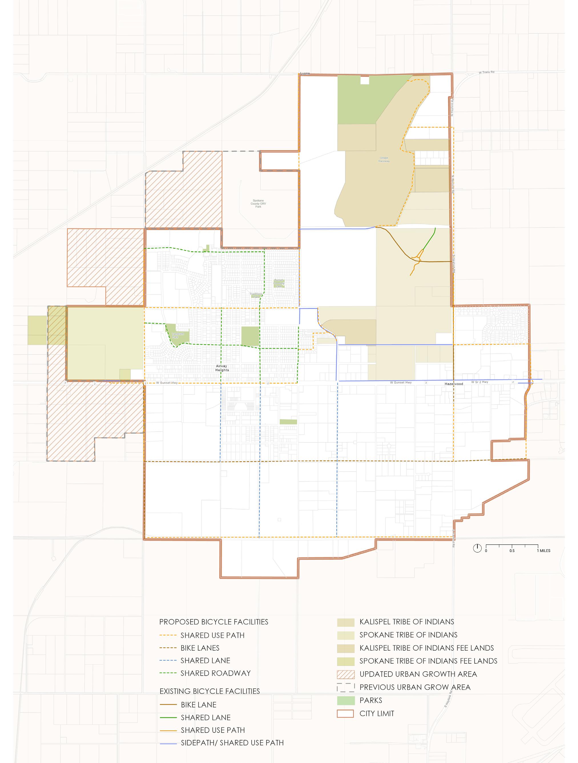
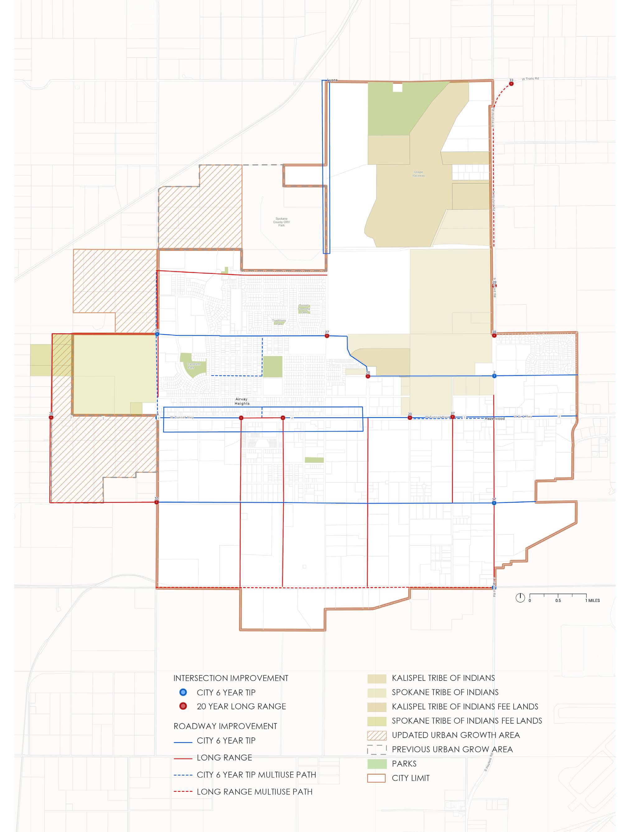
The Comprehensive Plan’s Vision includes 10 big ideas and 12 Goals. Each big idea and goal applies selectively to each element.
Idea 1. Plan for a community where people can a ord to live and work
Idea 2. Plan for a walkable and bikeable community
Idea 3. Plan for full-service neighborhoods with access to goods and services near residential neighborhoods
Idea 4. Implement Plans for the Downtown
Idea 5. Provide more variety in housing types to support a multi-generational and a ordable community
Idea 6. Expand parks, recreation, arts and cultural uses
Idea 7. Monitor growth to understand if the City is accomplishing community goals and priorities
Idea 8. Maintain and expand access to high-quality education in Airway heights
Idea 9. Transform Highway 2 to be attractive and reflect the priorities for Airway Heights
Idea 10. Plan, build, and maintain infrastructure and municipal facilities in the City necessary to support the City’s Comprehensive Plan
G.01 Grow and sustain a balanced, resilient economy for Airway Heights, providing jobs, community prosperity, and fiscal health.
G.02 Maintain and improve the provision of high-quality, affordable, and efficient community services in Airway Heights.
G.03 Maintain and improve Airway Heights’ small-town scale, unique civic identity, and aesthetic beauty.
G.04 Develop the historic city center as the “heart” of Airway Heights, enhancing its commercial, service and civic vitality.
G.05 Support provision of diverse housing types in Airway Heights, serving all residents and keeping neighborhoods safe, vital, and attractive.
G.06 Maintain and improve Airway Heights’ transportation network, on pace and in concert with needs including traffic flow, land use character, and community value.
G.07 Plan for and establish types and quantities of land uses in Airway Heights that support community needs, promote service efficiency, and fiscal sustainability.
G.08 Protect and maintain Airway Heights’ natural resources including clean air, soils, wetlands and ground water, and minimize light and noise pollution citywide.
G.09 Maintain and improve Airway Heights’ parks and recreational opportunities, sustaining an attractive, safe and functional system for all, with every home located within the service area of a park.
G.10 Sustain and expand Airway Heights’ arts, cultural, and civic environment.
G.11 Maintain the City of Airway Heights’ long-term fiscal health.
G.12 Involve the community of Airway Heights in all local government planning and decision-making, helping develop and implement plans for the city’s future.
P.01
Support land use patterns that:
• Maintain or enhance community levels of service.
• Foster the long-term fiscal health of the community.
• Maintain and enhance resident quality of life.
• Promote compatible, well-designed development.
• Implement goals and policies of the comprehensive plan, related master plan and/or facility plans.
• Are compatible with FAFB and airport overlay areas.
• Support a walkable and bikeable City.
• Provide a range of housing types and options.
• Support living wage employment opportunities for its residents.
• Encourage travel demand reduction through use of mixed-use residential, commercial, and institutional development.
• Advance multimodal facilities to reduce reliance on single-occupancy vehicles.
• Promote connectivity between developments.
P.02
Apply or revise zoning designations with careful consideration of factors including:
• Future land use mapping.
• Compatibility with surrounding land uses.
• Restrictions in FAFB and airport overlay areas.
• Infrastructure and service plans.
• Existing and future traffic patterns are supported through a street network classified by function that enforces multimodal design standards on the City and private development.
• Goals and policies of the Comprehensive Plan, related Master Plan, and/or Facility Plans.
• Housing needs and affordability for all income ranges.
• Economic development and implementation of the Downtown Plan.
• Implementation of the Industrial Sub-Area Plan.
P.03
P.05
Maintain concurrency between the Comprehensive Plan Land Use Element and available funding, ensuring efficient and timely levels of service (LOS) provision.
To maintain mobility that allows for existing vehicle movements while balancing the need to support traffic growth within a developing community, the City will maintain a concurrency/LOS mobility standard consistent with those proscribed by Airway Heights Traffic Impact Study Standard Guidelines, and required through Airway Height Municipal Code 14.09 for Transportation Concurrency.
Encourage development patterns that provide suitably-scaled, daily needs services within ¼ mile of residential areas, allowing a measure of independence for those who cannot or choose not to drive.
Strategy
• Identify small-scale neighborhood commercial sites that are suitable to service existing and planned residential development. These should be located along transit corridors.
• Ensure access to STA transit access is within ¼-mile of multifamily and large-scale single-family residential centers.
• Ensure access to parks within the 10 minute or ¼ mile of residential areas.
• Promote connectivity between developments.
Action
• Rezone areas suitable for neighborhood commercial development following public outreach engagement.
• Assess, plan, and implement multi-modal transportation needs for neighborhood commercial areas.
• Promote the development of park spaces, including pocket parks, trails, multi-use paths, and more.
P.06
Plan for compact, pedestrian-oriented development patterns in neighborhoods and commercial areas.
Strategy
• Develop and maintain design standards for pedestrian-oriented environment.
• Ensure access to STA transit within ¼-mile of multifamily and large-scale single-family residential centers.
• Promote the integration of pedestrian-friendly designs into subdivisions, incorporating features such as landscape boulevards, buffers, street art, “pocket” parks, traffic control measures, and pedestrian/bicycle infrastructure, such as benches and bike racks.
• Require private developments to conduct bicycle and pedestrian analyses, along with traffic impact analyses, as determined by the City engineer during scope sessions.
• Enforce Multimodal Level of Service (LOS) goals for private development, incentivizing compliance by offering reductions in the City traffic impact fee for meeting these standards. (See Transportation Section for multimodal LOS standards/definition.)
Action
• Develop new pedestrian-oriented design standards that will support missing middle housing development and human-scaled neighborhood design with an emphasis on ground-related housing.
• Initiate discussions with SR 2 commercial owners regarding signs and design standards (including street trees) and the need for public intervention in the rejuvenation of SR 2.
• Develop design guidelines for commercial development on SR 2 which is pedestrian friendly, encourages a grouping of like activities, and is architecturally consistent.
P.09
Require, when possible, traditional residential development patterns, typically featuring:
• Housing that faces the street edge.
• Utilization of alleys for parking and service access.
• An interconnected grid or small-block street network of 300~350-foot-long blocks.
• Extension of the arterial and grid street network applied to all development.
• Cul-de-sac and curvilinear street patterns should be limited.
• Street sections designed for safety, traffic calming, and aesthetic appeal, including narrower lanes, sidewalks, bike facilities, landscaping, and lighting.
Strategy
• Review the development code and best practices to identify updates to the development standards to reinforce traditional residential development patterns.
Action
• Update development standards in the zoning code to implement traditional residential development patterns.
• Update the public works standards to require connections by development to the existing street network and extend the grid street network into undeveloped and urban growth areas.
Prioritize location of schools in areas with:
• Access to arterial and collector streets.
• Ample sidewalks, bike, and pedestrian access.
• Proximity to residential areas being served.
• Cost-effective access to necessary utilities and services.
• Locations with multiple street access.
P.10
Prioritize location of new industrial development in areas that provide:
• Close proximity to major transportation corridors including in the industrial sub-area and along 21st Avenue.
• Siting near existing industrial uses, where possible.
• Cost-effective access to utilities and services.
• Access to transit to reduce employee vehicle trips.
• Paved roadway access to arterials.
• Ability to minimize trucking through residential areas.
P.12
With Spokane County and service providers, coordinate development patterns and the transportation network in Airway Heights’ Urban Growth Area (UGA), helping prevent adverse consequences for future incorporation.
Strategy
• Prohibit UGA (Urban Growth Area) boundary adjustments that impose excessive burdens on Airway Heights citizens for extending utilities or transportation infrastructure.
• Require adjacent agencies or private developments to conduct infrastructure needs assessments for land development projects seeking incorporation into the Airway Heights UGA, ensuring the identification and acceptance by City officials of adequate utility or transportation mitigations before incorporating new development.
P.18
Consider location of multi-family development in areas that:
• Can be integrated into existing neighborhood development patterns, ensuring compatibility in building scale and neighborhood character, replicating neighborhood design elements, and supporting a pedestrianfriendly environment. Examples include: limiting number of units in buildings limiting the building height to 1-2 stories requiring buildings to be along street frontages, creating a clear entrance and space related to the street requiring differing building forms built on a neighborhood block scale such as mixes of duplex, triplex, fourplex, courtyard apartments, townhomes and cluster housing.
• Can be designed to minimize large surface parking lots and promote shared parking, requiring parking on the interior of the site, behind buildings.
• Provide a transition between higher- and lower-intensity development patterns.
• Are appropriate and compatible with existing land uses.
• Are part of projects involving mixed-use or master-planned areas.
• Have convenient access to STA transit via use of pedestrian and/or bike accommodations (i.e. sidewalk, pathways, bike lanes, etc.)
• Have access to a collector or arterial .
• Do not concentrate multifamily developments in an area of the city, but rather distributes them throughout the community to avoid concentrations.
P.19
Maintain safe and efficient, multi-modal traffic flows throughout Airway Heights, measured and monitored using adopted Level of Service (LOS) standards.
Strategy
• Maintain a multi-modal level of service for the City that may differentiate between neighborhoods such as Downtown and residential neighborhoods.
• Encourage complete streets design for roadways and provide design guidelines on street elements configuration.
• Encourage extension of the multiuse path system.
• Provide administrative and financial assistance to support developmentborne costs for roadway improvements adjacent to site.
• Encourage street lighting.
• Encourage frontage and landscaping improvements to the roadway edge including for US-2.
• Encourage extension of grid system and connection roadway network in the City and into the UGA.
• Develop safe crossings, multi-modal options, and improve US-2 to slow traffic through downtown.
Action
• Enforce Multimodal Level of Service (LOS) goals for private development, incentivizing compliance by offering reductions in the City traffic impact fee for meeting these standards. (See Transportation Section for multimodal LOS standards/definition.)
• Leverage and develop the development traffic impact analyses to address multimodal Level of Service (LOS), at the discretion of the City engineer.
• Develop a new multi-modal level of service standard for the City, Downtown, and other neighborhoods as appropriate.
P.20
Develop and enhance a transportation system in Airway Heights that:
• Facilitates the safe, efficient movement of people, goods, and services.
• Supports non-motorized and recreational needs.
• Supports land use objectives.
• Promotes livable neighborhoods.
• Increases access to and encourages the use of public transit.
• Improves safe pedestrian and bike routes to schools, housing, employment areas, and between communities.
• Encourages completion of the street grid and improved alley access for development of low density, medium density, and infill housing.
• Provides a residential grid network that ensures multimodal mobility between developments, recreation, services, and schools along City collectors and arterials.
• Implements sound access management techniques by providing connectivity between contiguous commercial developments off the street system.
P.21
Improve year-round access, safety, utility, convenience and service levels for alternative modes of transportation, including:
• Walking.
• Bicycling.
• Public transit services.
• Rideshare/carpooling.
• Use of boulevards and landscape buffers designed consistent with City Standards that provide for snow storage that keep roads, bike lanes, and sidewalk/paths accessible year-round.
• Development that promotes complete streets, improves access to STA transit, and/or provides shelters/storage for active transportation to improve multimodal LOS.
• Businesses and residential developments that encourage commute trip reduction strategies, which can also improve multimodal LOS.
P.22
Maintain and improve the continuity of sidewalks, trails, and bicycle paths in Airway Heights.
Strategy
• Develop and maintain a Master Sidewalk and Pedestrian Network Plan that engineers and planners can use to coordinate the advancement of active transportation facilities.
• Enforce Multimodal Level of Service (LOS) goals for private development, incentivizing compliance by offering reductions in the City traffic impact fee for meeting these standards. (See Transportation Section for multimodal LOS standards/definition.)
P.23 Work to improve street and trail connectivity and quality in all areas of Airway Heights, improving walkability, public health and safety, and transportation efficiency.
Strategy
• Develop and maintain a Master Sidewalk and Pedestrian Network Plan that engineers and planners can use to coordinate the advancement of active transportation facilities.
• Enforce Multimodal Level of Service (LOS) goals for private development, incentivizing compliance by offering reductions in the City traffic impact fee for meeting these standards. (See Transportation Section for multimodal LOS standards/definition.)
P.24 Coordinate transportation planning and provision efforts with the Washington State Department of Transportation (WSDOT), Spokane Regional Transportation Council (SRTC), Spokane County, the City of Spokane, and other nearby cities.
P.25 Participate and coordinate Airway Heights objectives with interjurisdictional and regional planning for commercial air travel and air freight services.
P.26 Coordinate all long-range community planning objectives with Fairchild Air Force Base (FAFB), minimizing or eliminating operational or land use conflicts.
P.27 Maintain infrastructure and personnel at levels that provide Airway Heights residents with services that are high-quality, effective, and affordable.
P.28 On a regular basis, review and update the Capital Improvement Plan (CIP) and all related plans incorporating factors including:
• Population growth.
• Demographic trends.
• Building permit trends.
• Regional facility improvements and projections.
• Capital funding sources, including the transportation benefit district and traffic impact fees.
P.29 Support and cooperate with other agencies and providers of public services to maintain identified Levels of Service (LOS).
Strategy
• Collaborate with adjacent jurisdictions and the Washington State Department of Transportation (WSDOT) to maintain performance and Level of Service (LOS) standards for intersections and roadways. Work to ensure that the LOS needs of these agencies are met for large development projects, including providing potential mitigation for transportation impacts.
P.30 Plan new development to ensure provision of public services at current Levels of Service (LOS) or the LOS identified in City-adopted Master Plans.
Strategy
• Require development projects to demonstrate transportation concurrency by applying the City’s traffic impact analysis standards and process.
• Require development projects to meet the water concurrency requirements as set forth in the Airway Heights Municipal Code (AHMC) chapter 14.
• Enforce Multimodal Level of Service (LOS) goals for private development, incentivizing compliance by offering reductions in the City traffic impact fee for meeting these standards. (See Transportation Section for multimodal LOS standards/definition.)
P.34 Sustain and enhance the City’s fiscal stability through good capital planning and use of a wide array of financial tools to fund infrastructure needs.
P.35 Work towards compliance with accessibility requirements in accordance with Americans with Disability Act (ADA).
P.36 Guide annexation decisions by and considering:
• Master plans for water, sewer, transportation, parks, and emergency services.
• Provision of necessary rights-of-way and easements.
• Studies that evaluate environmental and public service factors.
• Timing that supports orderly development and/or coordinated extension of public services.
• Comprehensive Plan goals and policies.
P.38 Require private development to pay traffic impact fees proportionately to support infrastructure construction as a function of the concurrency and/or SEPA approval processes.
P.40 With Spokane County, base determination of Urban Growth Area (UGA) limits considering:
• Land use forecast and demands.
• Future service capabilities.
• Infrastructure planning.
• Ground and surface water provision and quality.
• Protection of public health.
• Transportation impacts.
P.53 Develop a robust multimodal network that supports land use development, increasing the number of residents who work, live, and recreate in Airway Heights. This will stimulate local commerce and promote outside investment within the City.
P.54 Invest in a multimodal transportation network to promote the efficient movement of freight and commuters between residential and commercial centers. Residents and workers that can effectively access services and goods are more likely to invest in Airway Heights, elevating business incomes and promoting the tax base.
P.55 The provision of multimodal choices allows Airway Heights citizens to benefit from reduced travel costs and healthier lifestyles via walking, biking, and/or ridership of STA transit. Promotion of mixed-use developments with affordable housing and employment opportunity, in combination with multimodal facilities, allows citizens the opportunity to reduce their transportation footprint on City and regional roadways and highways, which reduces infrastructure costs/impacts and improves air and stormwater runoff qualities.
P.56 Require the development or Develop Standards for context-sensitive streets to provide “place” for pedestrian, bicycle, and transit accommodation, incorporating (as appropriate) landscape, artistic, and traffic calming enhancements to affect the community vision for the City. Improvements such as boulevards and landscape buffers, street/pathway art, “pocket” parks, speed control measures, and pedestrian/bike infrastructure (benches, bike racks, etc.) are examples of applications that appeal to commuters and recreational travelers.
P.57 Anchor the city center with walkable/bicycle facilities, incorporating traffic controls, calming measures, strategically located parking, and wayfinding to slow or divert traffic from the vibrant city center. This approach creates a sense of place for active transportation.
P.58 Implement downtown zoning with a focus on businesses that promote synergy with nearby residential accessibility, transit, and active commuting. This action aims to reduce the frequency of single-purpose trips to the downtown area.
P.59 Promote the development of appealing transportation facilities that complement the downtown/civic center by implementing development standards that incorporate context-sensitive designs and landscaping elements.
P.60 Develop a comprehensive multimodal transportation network that supports the development of commercial and residential land use, promotes the Airway Heights economy by facilitating the efficient movement of freight and goods, and provides transportation options to reduce travel demand, congestion, and reliance on single occupancy vehicles, and encourages healthier lifestyles.
P.61 Promote mixed commercial, service, and residential land use developments, incorporating transit and active transportation facilities to ease congestion, reduce single-occupancy vehicle use, and encourage healthier lifestyles.
P.62 Encourage mixed use development in commercial areas with the DNL 65-69 designation, as indicated on the land use map. Promote mixed-use projects in these areas to incorporate multimodal facilities within the development, including trails, bike lanes or paths, and transit facilities, and ensure their integration with existing or planned multimodal projects.
• Encourage travel between the residential, work, and recreational land uses of site.
• Provide the local streets and access easements needed to promote travel off City arterials and collectors.
• Provides active transportation options (walking and biking) between land uses.
• Enforce Multimodal Level of Service (LOS) goals for private development, incentivizing compliance by offering reductions in the City traffic impact fee for meeting these standards.
P.63
Maintain a system of federally functional classified roadways to safely and efficiently accommodate projected travel demands for Airway Heights.
Strategy:
• Develop multimodal design standards for respective roadway classes, as defined with Transportation Section 1 of City Design Standards.
• Assure access management criteria per Section 2E of the Transportation section of City Design Standards is applied to assure the performance and safety of roadways.
• The Concurrency Standard of Municipal Code 14.09 is established to affirm classified roadways have the capacity to address forecast travel demands.
• Work to assure the 6-Year Transportation Improvement Program (TIP) is advanced at a pace commensurate with the gain in travel demands.
• Assure the traffic impact fee program is developed to support the funding of TIP projects.
• Coordinate with WSDOT and adjacent local agencies to coordinate classifications for shared roadways, and to affirm consistency in design.
P.64
Design or encourage development to provide multimodal application in private construction.
Strategy:
• Work with Spokane Transit to identify opportunities for fixed route stops or vanpool.
• Establish active transportation options (walking and biking) along corridors designated by mater pedestrian and bicycle plans.
• Establish context-sensitive designs that fit the character of neighborhoods.
• When appropriate, utilize traffic calming measures (bulb-outs, islands, etc.) to slow traffic on multimodal corridors.
• Update and Maintain a Complete Street plan per City of Airway Heights Municipal Code 14.10.
• Develop context sensitive designs that promote the appeal of transportation facilities.
• Enforce Multimodal Level of Service (LOS) goals for private development, incentivizing compliance by offering reductions in the City traffic impact fee for meeting these standards.
P.65 Encourage development to organize Transportation Demand Management (TDM) strategies.
Strategy:
• Work with developers to establish mixed-use developments advanced with complete street networks.
• Encourage City businesses with 100 or more full-time employees to provide flextime or telecommuting schedule options.
• Provide ride-share options through organizations such as Spokane Transit or Commute Finder Northwest.
• Develop other TDM strategies in compliance with best practices.
• Document a commute trip reduction plan per City of Airway Heights Municipal Code Chapter 10.16.
• Use transportation technology (intelligent transportation systems, variable messaging, etc.) and wayfinding to help maintain the movements of traffic through the City.
• TDM and CTR strategies can result in reduced development trip generation, which could result in a reduction of traffic impact fees, as approved by the City Public Works director.
P.66
P.67
Work to develop bicycle facilities with City collectors and private development projects.
Strategy:
• Implement the network of paths and dedicated lanes for bicycle activity as identified in the City Comprehensive Plan.
• Develop multiuse paths, bike paths, or bike lanes along City collectors in accordance with the applicable provisions of the Comprehensive Plan.
• Require private development projects to conduct bicycle and pedestrian analyses and discussion in the traffic impact analyses, as determined by the discretion of the City engineer during scope sessions.
• Require private development to incorporate multiuse paths, bike paths, or bike lanes as part of the frontage improvement in a manner consistent with the bicycle master plan.
• Collaborate with private development to proactively plan for and preserve the right-of-way (ROW) needed for bicycle facilities.
Employ access management practices throughout the City to help preserve mobility and safety for area roadways.
Strategy:
• Incorporate the spacing guidelines outlined in Section 2E of the Transportation section in the City Design Standards to optimize the spacing of classified roadways within the network that supports mobility.
• Implement the minimum private development approach spacings defined in Section 2E of the Transportation section of City Design Standards to minimize the impact on traffic flow.
• Enforce the requirement for residential developments with more than 30 units/dwellings to provide secondary access through a separate street to meet mobility needs and ensure emergency service accessibility.
• Require adjacent commercial developments to establish connecting crosseasements between sites to provide for mobility off the city street system, particularly along U.S. 2.
• Promote shared access, as possible, to minimize the number of access points along City collectors and arterials.
P.68
P.73
Ensure that all City roads are designated as public, unless otherwise specified or approved by the City engineer or as specified in the City Municipal Code.
Strategy:
• An applicant petition for a private road is subject to approval by the City Engineer.
• The maintenance/upkeep of private roads will be the responsibility of the property owner.
• The minimum cross-section of a private road will be a 20-foot paved surface unless approved otherwise by the City engineer.
• A private street serving multi-family, mobile home parks, or commercial uses shall provide a 5-foot sidewalk on one side designed to prevent parking on the sidewalk.
• A private road will be limited to a volume of 300 average daily traffic or 30 trips per hour.
• Further definitions and guidelines for City streets are discussed with Section 2E of the Transportation section of City Design Standards.
Develop safe crossings, multi-modal options, and improve US 2 to slow down traffic through Downtown.
Strategy:
• Collaborate with WSDOT on US-2 design to ensure slower traffic and multimodal opportunities in the downtown core. Use a boulevard concept to ensure slower speeds, safe crossings, and beautification/shade trees.
• Establish connectivity and walkability north and south of US-2 so residents and visitors can safely explore both sides of downtown.
• Utilize greenspace, bollards, and safe crossing elements to separate motorized traffic from sidewalks, open spaces, and trails.
• Take immediate action to increase pedestrian safety. New crosswalks with signage, pavement tape, flex delineators, and planters are examples of quick and inexpensive changes that could drastically improve safety.
The City capacity standard is set by Chapter 14.09 “Transportation Concurrency” of the City of Airway Heights Municipal Code (AHMC). These standards are also detailed/advanced with the City of Airway Heights Transportation Impact Analysis Standards. The concurrency determination process is based on the below transportation capacity standards or thresholds that represent the mobility and safety expectations for Airway Heights:
A. ADT Street Capacity LOS D for the capacity of principal and minor arterials.
B. ADT Street Capacity LOS D modified, for major and minor collectors.
C. ADT Street Capacity LOS C for local access streets.
D. P.M. Peak Hour Intersection Capacity LOS D for signals and roundabouts.
E. P.M. Peak Hour Intersection/Approach Capacity LOS E, conditionally allowed, for unsignalized approach at intersections and driveways.
This Comprehensive Plan and City Traffic Impact Analysis Standards further defines the methods and application of transportation concurrency, summarized as a policy as follows.
Traffic operations (capacity) is primarily measured using the intersection level of service (LOS) methodologies of the current Highway Capacity Manual (HCM), as developed by the Transportation Research Board. A range of software options is acceptable for signalized and stop-controlled LOS calculations so long as methodologies are consistent with the HCM.
For traffic impact analyses, other transportation studies/plans, and applicable design reports, the LOS analysis should be provided for current, future baseline, and future project conditions at site driveways and study intersections. Per AHMC 14.09.045 “Concurrency Standard Affirmed,” the City maintains an LOS D standard for operations at signalized intersections and stop-controlled, unsignalized intersections. An LOS E condition is allowed at stopped approach to an unsignalized (stop-controlled) intersection so long as 95th percentile queues do not exceed turn-pocket lengths or five (5) vehicles in an approach or through-lane. A LOS E condition is allowed at site driveways (access to properties) so long as queues are contained on-site.
Roundabouts should operate at LOS D or better with a volume-to-capacity ratio of 0.90 or better for an approach. HCM software may be used for a planning- level analysis along City streets, but design review (any street) and any analysis of U.S. 2 junctions should be developed in SIDRA using assumptions developed through coordination with WSDOT.
When applicable, an assessment of street capacity should be performed to support a traffic impact analysis, other transportation studies/plans, and design reports per coordination with the City Engineers office. Intersection capacity is the primary standard upon which the City evaluates Concurrency. This planning-level assessment helps the City understand whether deteriorated capacity issues are the function of an intersection mobility constraints, or are characteristic of through- lane limitations. The City maintains a LOS C standard for streets, affirmed via the calculations described subsequently.
A street capacity analysis is performed by comparing current or forecast average daily traffic (ADT) volumes with the ADT capacity thresholds identified with the subsequent Table, as distinguished by functional classification and the number of primary lanes on the street. A volume-to-capacity (V/C) assessment that should be made by dividing the existing or forecasted volume by the applicable threshold. The V/C ratio of 0.79 or less indicates practical street capacity is available. An assessment of 0.80 to 0.99 should be noted as “approaching standard.” Finally, V/C noted at 1.0 or higher should be identified as surpassing available street capacities.
Practical roadway and intersection capacity standards are established by Airway Heights Municipal Code chapter 14.09 entitled “Transportation Concurrency.” What is not specified by AHMC is the Comprehensive Plan goal that the City maintains complete streets that promote “context-sensitive” solutions fulfilling multimodal and livability objectives of the community. City Complete Streets Policy is defined by AHMC to 14.10, primarily pertaining to the application and implementations of standards. The following provides multimodal goals that should be associated with policy, as reported through traffic impact analyses, other transportation studies/plans, and applicable design reports.
The City has developed context- sensitive, multimodal roadway mobility policy, as associated with a functionally-classified level of service (LOS) objectives. Multimodal LOS E is achieved by providing the minimum pedestrian and ADA design standards outlined by Public Works Standards/Details. For instance, sidewalk availability and ADA-compliant crossings are two measures used to achieve LOS E condition for residential local streets. Increased LOS are achieved by adapting additional solutions into street design. For instance, providing a landscaped protective buffer offset from curb by five feet with on-street parking and permeable pavement to reduce runoff would elevate status to LOS B, as the application of five context sensitive measures have been included with street design.
LOS C is the desired multimodal target for the City. A 2% reduction in City traffic impact fees would be offered for each application above LOS E. The City Public Works Director or City Engineer determines which applications are applicable for LOS application, and this would be approved administratively with the issues of the impact fee/concurrency certificate received with a new development project. A summary of the LOS thresholds with possible multimodal solutions/applications is shown by the table below.
1. Minimum requirement, 6-foot street-adjacent sidewalk, curb, and gutter
2. Minimum requirement, full ADA compliance
3. Protective buffer between curbing and 6-foot sidewalk, min. 3 feet
4. Landscaped protective buffer between curbing and 6-foot sidewalk, min. 5 feet
5. Defined street-parking, min. 8-feet lane(s), delineated (provided both sides to narrow or staggered either side for traffic-calming purposes)
6. Multiuse pathway, min. 10 feet (replace sidewalk one or both sides)
7. Multimodal access provided to parks, schools, Spokane Transit, etc.
8. Contextual pavement-crossing designs (concrete, colored pavement, brick, etc.)
9. Provision pedestrian amenities (pocket park, street art, benches, etc.)
10. Creative stormwater collection, treatment, disposal, etc.
11. Application of traffic calming to control traffic speeds
a. Speed-control measures like chicanes, chockers, bulb-outs, shifts, medians, traffic circles, on-street parking, etc.
b. Cut-through control measures such as closures, diverters, misalignments, etc.
Collector Street Applications
1. Minimum requirement, 6-foot street-adjacent sidewalk, curb, and gutter.
2. Minimum requirement, full ADA compliance.
3. Protective buffer between curbing and 6-foot sidewalk, min. 4-feet
4. Landscaped protective buffer between curbing and 6-foot sidewalk, min. 8 feet
5. Multiuse pathway, min. 8 feet (replace sidewalk one or both sides)
6. On-Street bike lanes provided, 5-min from curb (6 feet with grated storm inlets)
7. Multimodal access provided to parks, schools, transit (off-corridor). etc.
8. Transit facilities provided per coordination with STA
9. Contextual pavement crossings at intersections or midblock (concrete, colored pavement, brick, unique signing or striping, etc.)
10. Provision pedestrian amenities (pocket park, street art, benches, etc.)
11. Intersections and approach accommodate design vehicle
12. AASHTO Sight Distances maintained for intersections and approach
13. Mixed-use development that includes small shop or services (reduce travel demand)
1. Minimum requirement, 6-foot street-adjacent sidewalk, curb, and gutter.
2. Minimum requirement, full ADA compliance.
3. Protective buffer between curbing and 6-foot sidewalk, min. 5 feet
4. Landscaped protective buffer between curbing and 6-foot sidewalk, min. 10 feet
5. Multiuse pathway, min. 10-feet (replace sidewalk one or both sides)
6. Conditionally, on-street bike lanes provided, 5-min from curb (6 feet with grated storm inlets)
Arterial Applications
7. Contextual bike lanes applied (pavement coloring, bike boulevards, buffered bike lanes, etc.)
8. Multimodal access provided to parks, schools, public facilities, etc.
9. Transit facilities provided per coordination with STA.
10. Controlled pedestrian crossing provided at major intersections (RRFB, HAWK, signal, etc.)
11. Provision pedestrian amenities (pocket park, street art, benches, etc.)
12. Intersections and approach accommodate design vehicle
13. AASHTO Sight Distances maintained for intersections and approach
14. Shared access and/or easements provided between properties.
Example References:
• ITE Traffic Calming Measures, https://www.ite.org/technical-resources/traffic-calming/traffic-calmingmeasures/
• Context Sensitive Designs, Implementing Context Sensitive Design Handbook (ITE, 2010)
• Bicycle Design Measures, Guide for the Development of Bicycle Facilities (AASHTO, 2012)
• Bicycle Design Measures, Urban Bikeway Design Guide (NACTO, 2011)
• Pedestrian Facilities, Guideline for the Planning, Design, and Operation of Pedestrian Facilities (AASHTO, 2nd Edition, 2021)

The provision of services, utilities, and facilities is the primary purpose of any general- or special-purpose governmental agency and is direct evidence of the taxpayer’s and utility customer’s dollar in action. Governments, in many ways, are like businesses, which provide goods and services in exchange for tax dollars, fees, and utility billings. Their goal should be to provide the maximum benefits given a limited revenue base. This demands proper planning and efficient utilization of funds.
Planning plays a significant role in capital expenditures programming by providing a growth framework by which potential expenditures may be evaluated. For example, an area may be projected for industrial expansion, but is lacking necessary water and sewer utilities. Should the local government wish to stimulate development in this area, it can plan for and participate in the construction of these utility systems. On the other hand, lands retained for rural uses will demand relatively little expenditure of limited revenues.
Planning can also anticipate city utilities needs which will be generated by development, and propose a system for making those improvements. Other governmental agencies benefit from a plan that provides predictable growth patterns for the future. School districts can utilize planning data when forecasting student enrollments and space needs. Fire Departments can utilize the plan to project future revenues and specialized equipment needs to accommodate specific types of
development. It can be seen that planning is the foundation of capital improvement programming for the City.
This section presents the overview of existing utilities systems in Airway Heights as well as needs forecast over the course of this plan’s 20-year horizon. As with other elements, this chapter also presents topic specific listings from the City’s overall goal and policy framework.
The City is developing agreements and facilities to meet the projected demand for the 6 year and 20 year planning horizon and coordinating these with the City’s Mater Water Plan. This includes several options for development of both annual and instantaneous water supplies. The expected water demand has been projected utilizing the studies in Volume II of this plan and coordinated with land use demand.
As the City develops further, expansion of the sewer system to collect flows from new developments will be necessary. There are still areas of the City that are still utilizing septic systems for wastewater treatment and extension of the sewer collection system to eliminate those septic tank systems is necessary. The Water Reclamation Plant(WRP) is in need of upgrades to the membrane treatment system and upgrades to the SCADA control system as well. As the City continues
to grow and develop, analysis of the WRP treatment capacity and possible expansion of the WRP may be necessary.
Non-city utility providers will experience increased demand for services as the City grows and will need to plan for new or improved facilities. As new technologies for Internet, wireless telephone, and other telecommunications systems are implemented, these improvements will further the City’s goal of economic growth and competitiveness. Through its land use regulation and permitting authority, the City should ensure that these utilities are broadly available to residents and businesses throughout the City, and that there are not excessive visual impacts within existing neighborhoods and local centers.
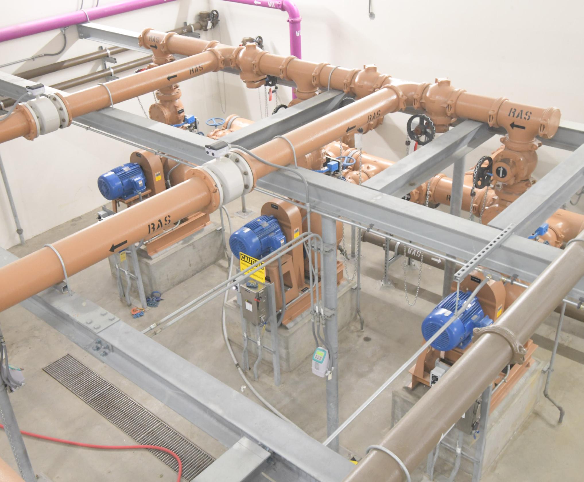
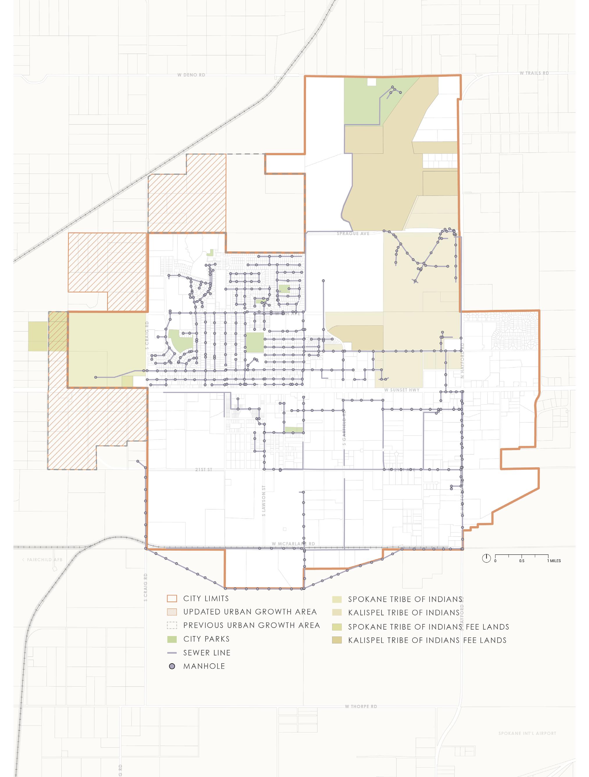
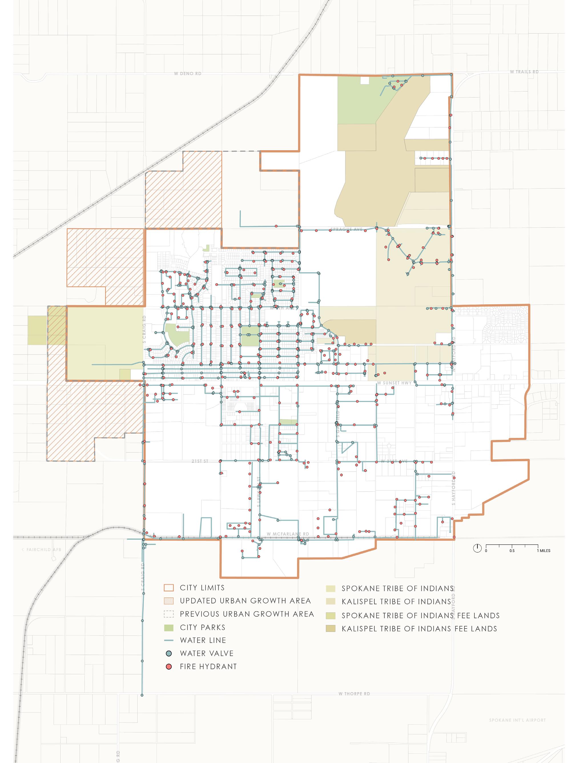
The Comprehensive Plan’s Vision includes 10 big ideas and 12 Goals. Each big idea and goal applies selectively to each element.
Idea 1. Plan for a community where people can a ord to live and work
Idea 2. Plan for a walkable and bikeable community
Idea 3. Plan for full-service neighborhoods with access to goods and services near residential neighborhoods
Idea 4. Implement Plans for the Downtown
Idea 5. Provide more variety in housing types to support a multi-generational and a ordable community
Idea 6. Expand parks, recreation, arts and cultural uses
Idea 7. Monitor growth to understand if the City is accomplishing community goals and priorities
Idea 8. Maintain and expand access to high-quality education in Airway heights
Idea 9. Transform Highway 2 to be attractive and reflect the priorities for Airway Heights
Idea 10. Plan, build, and maintain infrastructure and municipal facilities in the City necessary to support the City’s Comprehensive Plan
G.01 Grow and sustain a balanced, resilient economy for Airway Heights, providing jobs, community prosperity, and fiscal health.
G.02 Maintain and improve the provision of high-quality, affordable, and efficient community services in Airway Heights.
G.03 Maintain and improve Airway Heights’ small-town scale, unique civic identity, and aesthetic beauty.
G.04 Develop the historic city center as the “heart” of Airway Heights, enhancing its commercial, service and civic vitality.
G.05 Support provision of diverse housing types in Airway Heights, serving all residents and keeping neighborhoods safe, vital, and attractive.
G.06 Maintain and improve Airway Heights’ transportation network, on pace and in concert with needs including traffic flow, land use character, and community value.
G.07 Plan for and establish types and quantities of land uses in Airway Heights that support community needs, and promote service efficiency, and fiscal sustainability.
G.08 Protect and maintain Airway Heights’ natural resources including clean air, soils, wetlands and ground water, and minimize light and noise pollution citywide.
G.09 Maintain and improve Airway Heights’ parks and recreational opportunities, sustaining an attractive, safe, and functional system for all, with every home located within the service area of a park.
G.10 Sustain and expand Airway Heights’ arts, cultural, and civic environment.
G.11 Maintain the City of Airway Heights’ long-term fiscal health.
G.12 Involve the community of Airway Heights in all local government planning and decision-making, helping develop and implement plans for the city’s future.
P.10 Prioritize location of new industrial development in areas that provide:
• Close proximity to major transportation corridors including in the industrial sub-area and along 21st Avenue.
• Siting near existing industrial uses, where possible.
• Cost-effective access to utilities and services.
• Access to transit to reduce employee vehicle trips.
• Paved roadway access to arterials.
• Ability to minimize trucking through residential areas.
P.28 On a regular basis, review and update the Capital Improvement Plan (CIP) and all related plans incorporating factors including:
• Population growth.
• Demographic trends.
• Building permit trends.
• Regional facility improvements and projections.
• Capital funding sources, including the transportation benefit district and traffic impact fees.
P.29 Support and cooperate with other agencies and providers of public services to maintain identified Levels of Service (LOS).
Strategy
• Collaborate with adjacent jurisdictions and the Washington State Department of Transportation (WSDOT) to maintain performance and Level of Service (LOS) standards for intersections and roadways. Work to ensure that the LOS needs of these agencies are met for large development projects, including providing potential mitigation for transportation impacts.
P.30 Plan new development to ensure provision of public services at current Levels of Service (LOS) or the LOS identified in City-adopted Master Plans.
Strategy
• Require development projects to demonstrate transportation concurrency by applying the City’s traffic impact analysis standards and process.
• Require development projects to meet the water concurrency requirements as set forth in the Airway Heights Municipal Code (AHMC) chapter 14.
• Enforce Multimodal Level of Service (LOS) goals for private development, incentivizing compliance by offering reductions in the City traffic impact fee for meeting these standards. (See Transportation Section for multimodal LOS standards/definition.)
P.32
P.34
Plan and locate private and public utilities consistent with best management practices.
Sustain and enhance the City’s fiscal stability through good capital planning and use of a wide array of financial tools to fund infrastructure needs.
P.40 With Spokane County, base determination of Urban Growth Area (UGA) limits considering:
• Land use forecast and demands.
• Future service capabilities.
• Infrastructure planning.
• Ground and surface water provision and quality.
• Protection of public health.
• Transportation impacts.
The Capital Facilities element provides summary information derived from the most current Airway Heights Capital Facilities Plan (CFP), describing the City’s existing public facilities and the need for future facilities to address the requirements of a growing population. In conjunction with the CFP, this element provides guidance for the City to achieve its goal of providing public facilities appropriate and necessary to maintain service levels for residents and businesses.
The state Growth Management Act (GMA) requires communities to plan for capital facilities to ensure there is an adequate level of facilities and services in place to support development at the time of occupancy or use.
The CFP is a six-year plan for capital improvements that supports the City’s current and future population and economy. Identified improvements are to be fully funded. One key criterion for identifying CFP improvements are standards for “levels of service” (LOS). Accordingly, the CFP contains LOS standards for each public facility and requires that development be served by adequate facilities consistent with the land use element and concurrent with, or prior to, the impacts of development (i.e., the “concurrency” requirement.)
Capital Facilities element are required in order to:
1. Demonstrate intent and capacity to provide services associated with land development that is envisioned or authorized by the land use element of the comprehensive plan.
2. Maintain and improve the quality of life for existing and future residents by establishing and maintaining LOS standards.
3. Coordinate and provide consistency among all plans for capital improvements, including:
• Other elements of the Comprehensive Plan (i.e., land use and transportation elements).
• Other studies or topical plans led by local government.
• Plans for capital facilities of state and/or regional significance.
• Plans of adjacent local agencies or governments.
• Special district plans.
4. Ensure the timely provision of adequate facilities as required by GMA.
5. Document capital projects and their financing (including projects to be financed by impact fees and/or real estate excise taxes authorized by GMA).
The requirement to fully finance projects identified in the CFP provides a reality check on the goals and objectives set forth in the Comprehensive Plan. Additionally, the capacity of facilities described in the CFP affects the size and configuration of growth within City limits as well as in its urban growth area (UGA).
The GMA requires cities to provide and maintain services on-pace with growth, developing and updating Capital Facilities Plans (CFPs) to identify needs and budget accordingly. In most cases, doing so relies on service benchmarks known as Levels of Service (LOS).
Some LOS standards are easy to quantify, such as traffic volume capacity per mile of road, or acres of park per capita. Other LOS standards are more difficult to quantify, in which case cities may elect to adopt regionally-adopted standards
or provide guideline-level standards that advise facilities improvements. Regardless, communities have significant latitude in establishing LOS thresholds, allowing cities to address needs in context of other policy objectives, LOS standards in surrounding areas, and other factors.
Figure 37 below lists adopted LOS standards for Airway Heights’ services. For purposes of comparison, this table also lists LOS minimum standards adopted by the Spokane County Steering Committee.
Airway Heights’ CFP calls for extensive infrastructure requirements over its six-year planning period. These are listed in Figure 38 below, along with the estimated expenditures necessary to fund the projects. All of the projects listed have been classified as essential needs, meaning it is imperative to meet level of service standards.
FIGURE 37. LEVEL OF SERVICE STANDARD
Service Airway Heights LOS
Transportation See the Transportation Element for Multi-modal LOS
Parks 10 acres / 1,000 population
Police 1.6 officers / 1,000 (non-institutional) population
Fire
6-minute average response time and Fire Insurance Rating of 6 or less
Emergency (EMS) 6-minute average response time
Water
30 residential,40 psi non-residential, Minimum 20 psi system pressure during any single fire event; ERU is defined as 362 gallons per day
Solid Waste Regional Standard
Libraries .41 square foot per capita per Library District
1 = Equivalent residential unit (ERU) is defined as 362 gallons per day (GPD) or as defined in the latest adopted Comprehensive Water System Plan
2 = Generalized LOS minimum per North American Highway Capacity Manual, see transportation element for multi-modal service standards
3 = BLS is Basic Life Support and ALS is Advanced Life Support
Joint Public Facility The City is in the process of developing a joint public facility that combines the City Hall, Fire Station, Police Station, Municipal Courts, and Building and Planning Departments into a single building. The total estimated cost is $20 million, which includes the renovation of the 1149 S. Garfield Road building to accommodate courts, finance, and administrative functions ($5 million), as well as the renovation expenses to support police department requirements ($5 million), along with other costs.
Parks and Park Improvements
This includes capital investment for park land and development/ improvement to address forecast demand and maintain existing facilities to meet demand.
$20,000,000
$18,535,000 Police Department Police needs are planned to be addressed through current expense funds. -
Transportation Costs are based on a comprehensive list of transportation system improvements included in the six-year TIP and likely to be addressed within the 20-year horizon of this comprehensive plan.
Water These water system improvements are drawn from the most recent water system plan.
Sewer These sewer system improvements are drawn from the most recent water system plan.
Total
~$158,980,800
$39,300,000
$41,139,000
$ 277,954,800

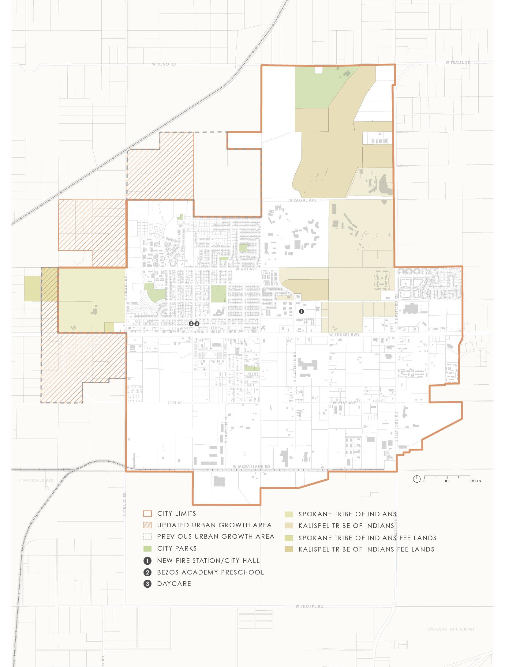
The Comprehensive Plan’s Vision includes 10 big ideas and 12 Goals. Each big idea and goal applies selectively to each element.
Idea 1. Plan for a community where people can a ord to live and work
Idea 2. Plan for a walkable and bikeable community
Idea 3. Plan for full-service neighborhoods with access to goods and services near residential neighborhoods
Idea 4. Implement Plans for the Downtown
Idea 5. Provide more variety in housing types to support a multi-generational and a ordable community
Idea 6. Expand parks, recreation, arts and cultural uses
Idea 7. Monitor growth to understand if the City is accomplishing community goals and priorities
Idea 8. Maintain and expand access to high-quality education in Airway heights
Idea 9. Transform Highway 2 to be attractive and reflect the priorities for Airway Heights
Idea 10. Plan, build, and maintain infrastructure and municipal facilities in the City necessary to support the City’s Comprehensive Plan
G.01 Grow and sustain a balanced, resilient economy for Airway Heights, providing jobs, community prosperity, and fiscal health.
G.02 Maintain and improve the provision of high-quality, affordable, and efficient community services in Airway Heights.
G.03 Maintain and improve Airway Heights’ small-town scale, unique civic identity, and aesthetic beauty.
G.04 Develop the historic city center as the “heart” of Airway Heights, enhancing its commercial, service, and civic vitality.
G.05 Support provision of diverse housing types in Airway Heights, serving all residents and keeping neighborhoods safe, vital, and attractive.
G.06 Maintain and improve Airway Heights’ transportation network, on pace and in concert with needs including traffic flow, land use character, and community value.
G.07 Plan for and establish types and quantities of land uses in Airway Heights that support community needs, and promote service efficiency, and fiscal sustainability.
G.08 Protect and maintain Airway Heights’ natural resources including clean air, soils, wetlands and ground water, and minimize light and noise pollution citywide.
G.09 Maintain and improve Airway Heights’ parks and recreational opportunities, sustaining an attractive, safe, and functional system for all, with every home located within the service area of a park.
G.10 Sustain and expand Airway Heights’ arts, cultural, and civic environment.
G.11 Maintain the City of Airway Heights’ long-term fiscal health.
G.12 Involve the community of Airway Heights in all local government planning and decision-making, helping develop and implement plans for the city’s future.
P.02 Apply or revise zoning designations with careful consideration of factors including:
• Future land use mapping.
• Compatibility with surrounding land uses.
• Restrictions in FAFB and airport overlay areas.
• Infrastructure and service plans.
• Existing and future traffic patterns are supported through a street network classified by function that enforces multimodal design standards on the City and private development.
• Goals and policies of the Comprehensive Plan, related Master Plan, and/or Facility Plans.
• Housing needs and affordability for all income ranges.
• Economic development and implementation of the Downtown Plan.
• Implementation of the Industrial Sub-Area Plan.
P.03 Maintain concurrency between the Comprehensive Plan Land Use Element and available funding, ensuring efficient and timely levels of service (LOS) provision.
To maintain mobility that allows for existing vehicle movements while balancing the need to support traffic growth within a developing community, the City will maintain a concurrency/LOS mobility standard consistent with those proscribed by Airway Heights Traffic Impact Study Standard Guidelines, and required through Airway Height Municipal Code 14.09 for Transportation Concurrency.
P.04 Ensure identification and siting of essential public facilities (EPFs) comply with state criteria, including RCW 36.70A.200, RCW 71.09.020(14), Office of Financial Management (OFM) EPF listings, and Countywide Planning Policies for Spokane County.
P.09
Prioritize location of schools in areas with:
• Access to arterial and collector streets.
• Ample sidewalks, bike, and pedestrian access.
• Proximity to residential areas being served.
• Cost-effective access to necessary utilities and services.
• Locations with multiple street access.
P.10
Prioritize location of new industrial development in areas that provide:
• Close proximity to major transportation corridors including in the industrial sub-area and along 21st Avenue.
• Siting near existing industrial uses, where possible.
• Cost-effective access to utilities and services.
• Access to transit to reduce employee vehicle trips.
• Paved roadway access to arterials.
• Ability to minimize trucking through residential areas.
P.27
Maintain infrastructure and personnel at levels that provide Airway Heights residents with services that are high-quality, effective, and affordable.
P.28
On a regular basis, review and update the Capital Improvement Plan (CIP) and all related plans incorporating factors including:
• Population growth.
• Demographic trends.
• Building permit trends.
• Regional facility improvements and projections.
• Capital funding sources, including the transportation benefit district and traffic impact fees.
P.29
Support and cooperate with other agencies and providers of public services to maintain identified Levels of Service (LOS).
Strategy
• Collaborate with adjacent jurisdictions and the Washington State Department of Transportation (WSDOT) to maintain performance and Level of Service (LOS) standards for intersections and roadways. Work to ensure that the LOS needs of these agencies are met for large development projects, including providing potential mitigation for transportation impacts.
P.30 Plan new development to ensure provision of public services at current Levels of Service (LOS) or the LOS identified in City-adopted Master Plans.
Strategy
• Require development projects to demonstrate transportation concurrency by applying the City’s traffic impact analysis standards and process.
• Require development projects to meet the water concurrency requirements as set forth in the Airway Heights Municipal Code (AHMC) chapter 14.
• Enforce Multimodal Level of Service (LOS) goals for private development, incentivizing compliance by offering reductions in the City traffic impact fee for meeting these standards. (See Transportation Section for multimodal LOS standards/definition.)
P.31 Promote the use of geographic information systems (GIS) as a means of improving the provision of city services, including:
• Enhancing planning and decision-making through GIS databases.
• Optimizing service delivery efficiency using GIS.
• Enhancing outreach engagement by creating interactive maps and dashboards that enable residents to access city services and provide feedback.
P.32 Plan and locate private and public utilities consistent with best management practices.
P.33
Provide timely, professional, and efficient processing of building permits, development review, and municipal code administration.
Sustain and enhance the City’s fiscal stability through good capital planning and use of a wide array of financial tools to fund infrastructure needs.
P.35 Work towards compliance with accessibility requirements in accordance with Americans with Disability Act (ADA).
P.36 Guide annexation decisions by and considering:
• Master plans for water, sewer, transportation, parks, and emergency services.
• Provision of necessary rights-of-way and easements.
• Studies that evaluate environmental and public service factors.
• Timing that supports orderly development and/or coordinated extension of public services.
• Comprehensive Plan goals and policies.
P.37 Continue participation in regional wastewater planning on the West Plains, updating wastewater master plans accordingly.
Coordinate with and support local emergency service providers.
P.40 With Spokane County, base determination of Urban Growth Area (UGA) limits considering:
• Land use forecast and demands.
• Future service capabilities.
• Infrastructure planning.
• Ground and surface water provision and quality.
• Protection of public health.
• Transportation impacts.
P.41 Cooperate with regulatory agencies in the identification and abatement of local environmental quality problems.
P.42 Protect the appearance and natural functions of critical areas in Airway Heights, using best available science (BAS) to protect functions and values, developing criteria including grading, setback, and vegetation disturbance.
P.43 Promote landscaping guidelines that:
• Protect wildlife habitats by maintaining existing trees and vegetative cover.
• Re-vegetate disturbed areas.
• Beautify streets, roadways, and surface parking lots.
• Help treat and address stormwater issues.
P.44 Provide storm water collection and treatment through use of landscaped infiltration areas and encourage the use of new or improved technology whenever practical.

The understanding of economic development patterns and opportunities within a city is an important factor in managing a city’s growth. The reason for this is that the economic status of a city plays such a major role in determining growth. If there are employment or business opportunities within a community, people will be attracted to the area. If there is a lack of these things, people will likely go elsewhere. For planning purposes, those cities where a great number of economic opportunities exist must be prepared to deal with substantial growth. In those areas where few opportunities exist, it is necessary to examine why that is, and what can be done to invigorate the city’s economy.
Planning also plays a major role in facilitating economic growth through land use decisions that are made in the Comprehensive Plan. It is important to ensure that there is ample land designated for commercial and industrial uses to fulfill the demand for these uses. A proper functioning relationship between supply and demand for commercial and industrial lands is vital to maintaining a smooth operating market.
The City of Airway Heights is faced with a unique economic situation. Even though the City itself is small in population, its location allows it to draw business from surrounding areas. As a result, the economic opportunities within the City are much greater than its size would indicate.
The Comprehensive Plan’s Vision includes 10 big ideas and 12 Goals. Each big idea and goal applies selectively to each element.
Idea 1. Plan for a community where people can a ord to live and work
Idea 2. Plan for a walkable and bikeable community
Idea 3. Plan for full-service neighborhoods with access to goods and services near residential neighborhoods
Idea 4. Implement Plans for the Downtown
Idea 5. Provide more variety in housing types to support a multi-generational and a ordable community
Idea 6. Expand parks, recreation, arts and cultural uses
Idea 7. Monitor growth to understand if the City is accomplishing community goals and priorities
Idea 8. Maintain and expand access to high-quality education in Airway heights
Idea 9. Transform Highway 2 to be attractive and reflect the priorities for Airway Heights
Idea 10. Plan, build, and maintain infrastructure and municipal facilities in the City necessary to support the City’s Comprehensive Plan
G.01 Grow and sustain a balanced, resilient economy for Airway Heights, providing jobs, community prosperity, and fiscal health.
G.02 Maintain and improve the provision of high-quality, affordable, and efficient community services in Airway Heights.
G.03 Maintain and improve Airway Heights’ small-town scale, unique civic identity, and aesthetic beauty.
G.04 Develop the historic city center as the “heart” of Airway Heights, enhancing its commercial, service, and civic vitality.
G.05 Support provision of diverse housing types in Airway Heights, serving all residents and keeping neighborhoods safe, vital, and attractive.
G.06 Maintain and improve Airway Heights’ transportation network, on pace and in concert with needs including traffic flow, land use character, and community value.
G.07 Plan for and establish types and quantities of land uses in Airway Heights that support community needs, and promote service efficiency, and fiscal sustainability.
G.08 Protect and maintain Airway Heights’ natural resources including clean air, soils, wetlands and ground water, and minimize light and noise pollution citywide.
G.09 Maintain and improve Airway Heights’ parks and recreational opportunities, sustaining an attractive, safe, and functional system for all, with every home located within the service area of a park.
G.10 Sustain and expand Airway Heights’ arts, cultural, and civic environment.
G.11 Maintain the City of Airway Heights’ long-term fiscal health.
G.12 Involve the community of Airway Heights in all local government planning and decision-making, helping develop and implement plans for the city’s future.
P.01 Support land use patterns that:
• Maintain or enhance community levels of service.
• Foster the long-term fiscal health of the community.
• Maintain and enhance resident quality of life.
• Promote compatible, well-designed development.
• Implement goals and policies of the comprehensive plan, related master plan and/or facility plans.
• Are compatible with FAFB and airport overlay areas.
• Support a walkable and bikeable City.
• Provide a range of housing types and options.
• Support living wage employment opportunities for its residents.
• Encourage travel demand reduction through use of mixed-use residential, commercial, and institutional development.
• Advance multimodal facilities to reduce reliance on single-occupancy vehicles.
• Promote connectivity between developments.
P.08
Encourage compatible infill development and redevelopment of vacant and under-utilized properties within City limits, ensuring compatibility with FAFB and airport overlay areas.
Strategy
• Review the development code and best practices to identify infill development standards including lot sizes, access to the roadway and utilities, and design standards for housing for missing middle and highdensity housing consistent with the Downtown Plan.
Action
• Update development standards in the zoning code to implement smalllot development standards and redevelopment in high-density areas consistent with the Downtown Plan.
• Develop a Geographic Information System (GIS) inventory and a Capital Improvement Program (CIP) or Transportation Improvement Program (TIP) strategy to address the infill of missing sidewalks along undeveloped sites, ensuring enhanced pedestrian and bicycle mobility and safety.
P.20 Develop and enhance a transportation system in Airway Heights that:
• Facilitates the safe, efficient movement of people, goods, and services.
• Supports non-motorized and recreational needs.
• Supports land use objectives.
• Promotes livable neighborhoods.
• Increases access to and encourages the use of public transit.
• Improves safe pedestrian and bike routes to schools, housing, employment areas, and between communities.
• Encourages completion of the street grid and improved alley access for development of low density, medium density, and infill housing.
• Provides a residential grid network that ensures multimodal mobility between developments, recreation, services, and schools along City collectors and arterials.
• Implements sound access management techniques by providing connectivity between contiguous commercial developments off the street system.
P.25 Participate and coordinate Airway Heights objectives with interjurisdictional and regional planning for commercial air travel and air freight services.
P.26 Coordinate all long-range community planning objectives with Fairchild Air Force Base (FAFB), minimizing or eliminating operational or land use conflicts.
P.47 Develop marketing programs to support community advancement, future development opportunities, and employment.
Action
• Implement a public relations campaign using local and regional news media to attract a wider range of visitors to the community.
• Monitor proposed urban zoning designations and developments elsewhere within the region and determine market requirements and potentials for commercial, office, and industrial uses in order to protect the interest of Airway Heights in the allocation of future development opportunities.
• Develop an information base that includes the current level and type of employment along with potential job location forecasts.
• Develop a community branding program.
P.48 Support revitalization of existing business and commercial districts in Airway Heights
Action
• Develop a business retention program to ensure the continued viability of existing businesses.
• Create parking and business improvement authorities in downtown area north of US-2.
• Create local improvement districts.
• Strengthen existing businesses and support reinvestment in downtown by enhancing the visibility, access, and concentration of local businesses.
P.69
Invest in drastic streetscape improvements and beautification efforts in Downtown.
Strategy:
• Develop streetscape designs along US-2 and King Street. Use green space, landscaping, street furniture, and pedestrian lighting to establish a multi-purpose, attractive, safe public space.
• Establish a public art program with a downtown focus area. Engage the community and local artists, partner with local nonprofits, and investigate the feasibility of a public art on loan program.
• Review and update zoning overlay districts and identify an opportunity zone to ensure design standards contribute to downtown development and success.
• Incorporate wayfinding and gateway signage throughout the city to improve connections between downtown and other areas. Such signage should include art elements and environmental knowledge, and should communicate a sense of arrival.
• Define a transition into downtown by constructing US-2 to provide traffic calming through the core, and by encouraging a greater density of buildings and activity in the core.
P.71
Strengthen existing businesses and support reinvestment Downtown.
Strategy:
• Invest in local businesses with a focus on maintaining existing ones. Partner with businesses, provide resources and education on maintenance requirements and opportunities, and enforce code consistently.
• Evaluate parking strategies, surface lots, and opportunities for infill and redevelopment as appropriate.
• Study infrastructure needs and funding for the downtown area south of US2.
• Leverage investment with grants, city funds, partnerships, and collaborate to foster downtown development that can be utilized for storefront improvement grants to local businesses.
• Study the benefits of vacating 13th and 14th avenues as a stimulus to private redevelopment along US-2 .
• Capitalize on business diversity and culture such as the variety of restaurants, colors, and ethnicity. Support unique designs, colorful buildings, and use of public art downtown.
P.72
Create and improve collaborative, inclusive and safe public spaces in the Downtown.
Strategy:
• Develop a civic campus south of US-2 and study the possibility of relocating city services there. The campus could be a non-profit/ government partnership and include a center with health/education services .
• Encourage activation of downtown public spaces. Examples could include community gardens, trails, pocket parks, etc.
• Re -envision Sunset Park as a northern downtown anchor. Develop a Master Park Plan that improves connections and integration with downtown.
• Involve the public in events and programs that get people excited about Downtown Airway Heights such as a public market and collaborative art.
• Utilize tactical urbanism approaches to initiate pilot projects such as parklets, bike lanes, street furniture, plazas, and traffic calming to inspire long-term change and gauge and seek community buy-in.