
PORTFOLIO OF HU DIE

HU DIE
Email die_hu@u.nus.edu
Tel: (+65) 87715841
EDUCATION & AWARDS
CONTENTS
Graduate Works
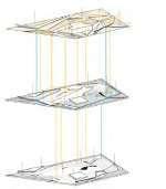
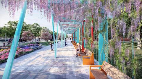
MORE THAN BLUE INFRASTRUCTURE: Community, Nature, Memory
Airport renovation, Water Infrastructure, Landscape Planning (Studio2 Project, Teamwork, 2021)
Education Awards
07/2018-08/2018
Beijing Century Chief International Architecture Design Co., Ltd.
Architect Intern (Nanjing,Jiangsu, China)
2021-Present
National University of Singapore, Singapore
Master of Landscape Architecture
CAP:3.90
2017-2021 2020 2019
Nanjing Tech University, China
Bachelor of Engineering, Landscape Architecture
GPA: 3.70/4.00, Rankng: 3rd
University Principal Scholarship (Top 1%)
School-Level Second-Class Scholarship (Top 10%)
EXPERIENCE
Internship
05-07/2022
RAMBOLL STUDIO DREISEITL
Landscape Architect Intern (Singapore)
Worked on 8 Shenton Way.
Digital Modeling, Detail Enriching, Urban Furniture Design, Plan Drawing,Presentation Preparation
Worked on Landscape of AEC The One.
Digital Modeling, Urban Furniture Design
05-07/2021
SWA Landscape Design Consulting (Shanghai) Co. Ltd.
Landscape Architect Intern (Shanghai,China)
Worked on Central Steel Park and Surrounding Area Landscape Design Competition.
Field Trip, Site 3D Modeling, Pre-Analysising, Concept Discussion, Detail Enriching, Boulevard Design, Services and Facilities Design, Presentation Graphics Preparing
Worked on Yango Songjiang Mixuse Park Design.
Digital Modeling, Construction Drawing
10/2020-01/2021
Valentien + Valentien Landschaftsarchitekten und Stadtplaner SRL
Landscape Architect Intern (Shanghai,China)
Worked on Baosteel Landscape Design.
Project details enriching, Strategic Analysis, Garden Design, Presentation Diagrams
Worked on Concept Proposal of Shanghai Community Science Park Project Landscape Design
Cooperated with senior designers in conceptual and schematic design, presentation diagrams
Worked on Chengdu New Industry Park Landscape Design.
Degital Modeling, Rendering
08-11/2022
Worked on Public Housing Design Project in Nanjing. Degital Modeling, CAD Drawing
National University of Singapore
Teaching Assisstant of Department of Architecture
Geo Design Lecture (Supervised by Dr. Jessica Ann Diehl)
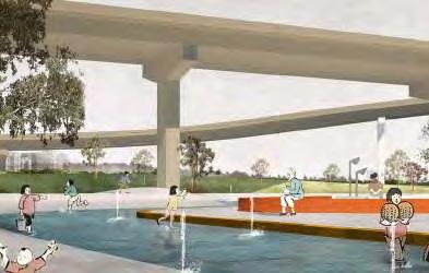
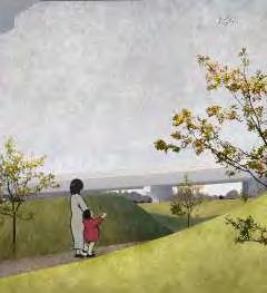
PLAB AS A HAPPY RESILIENT MODEL TOWN
Town Planning (Studio2 Workshop, Teamwork, 2021)
FROM RICE TO RISE: Agropolitan Revitalization Strategy for Mixed-Use Innovative Rice Development
05-07/2022
Workshop & Student Work
Agropolitan Territories, Human & Environment, Country-Scale Landscape Design (Studio3 Project, Teamwork, 2022)
Digital Landscape Techniques Lecture (Supervised by Dr. Ervine Lin)
Answering rhino/grasshopper-related questions from students
Reaching Assisstant of Department of Architecture
Answering gis-related technical questions from students, Helping with collating and marking students' uploaded work Research on the associations between urban landscapes and potential health benefits (Point Cloud Scanning, Photoshopping of panoramic images, 3D modeling of scanned sites, Using Grasshopper to generate simplified geometry for measurements)
11/2021 MLA Sem1 Studio Work was selected in NUS LA Biennial Yearbook
11/2021 Internatinal Geodesign Collaboration 2022
Prepared for IGC Submission.
Producted a final poster of Geodesign Analysis of Singapore
2017-2018
Member of Publicity Department of Student Union in Architecture School
Poster production, essay edition and type setting
PUBLICATION Hu, D. & Lu, Y. (2020). Landscape Design Research Based on Green Campus Labeling System: A Case Study of Nanjing Tech University. The Sixteenth International Conference on Green and Energy-Efficient Building & New Technologies and Products Expo, Suzhou Jiangsu, China.
Lu, Y., & Hu, D. (2020). Research on Wind Environment of “Sky-” Public Space of Hong Kong’s Public Housing. The Sixteenth International Conference on Green and Energy-Efficient Building & New Technologies and Products Expo, Suzhou Jiangsu, China.
PROFESSIONAL SKILLS
Graphic Photoshop, Adobe Illustrator, InDesign, Hand-drawing
Modeling Rhino(Grasshopper), AutoCad, Sketchup
Rendering Vray for Rhino, Lumion
Microsoft Office Word, Excel, Powerpoint
GIS Arcgis, Qgis
TURN 'COVERED' TO 'HOME': Landscape Enhancement of Covered Linkway and Their Surrounding Spaces In HDB Landscape and Social Interaction, Public Housing Landscape Design (Studio1 Project, Individual work, 2021)
Undergraduate Works
The Way Home for Oyster: Revival of Shajing
Large-Scale Ecological Design, Teamwork, 2020
Activation of Shanghai People's Square: Based on Automatic Driving Revolution
Middle-Scale Site Design + Urban Plaza Re-Design, Teamwork, 2020
Between Center And Edge: For Crystal Boys
Small-Scale Site Design + Monumental Landscape, Indivitual Work, 2020
Other Works
Internship Work
Location: Singapore
Type: Academic Group Work
(Hu Die, Jin Zhuoyin, Lin Lan)
Duration: 2022.01-2022.05
Tutor: Lehana Guo
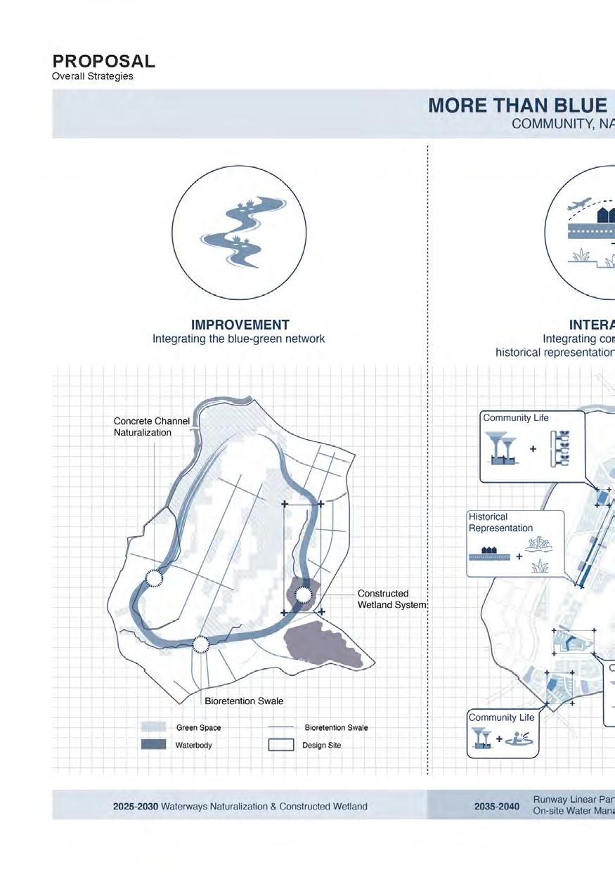
Water is always a vital resource for all humans, Singapore has been facing problems such as limited freshwater resources and over-reliance on imports. As a new town in the future, the increasing population in PLAB brings about increasing water demand, but the available water resources within the site are limited and depend on external water supply. In addition, PLAB was closely related to water in terms of production and living, but with waterways canalization, the relationship between people and water was estranged.
The project is aiming at maximizing the use of collected rainwater and greywater while transforming water management infrastructure into spatial landmarks to integrate the water system into people's daily life. Through innovative water management design, the following targets are:
1. Manage water quantity and quality while improving biodiversity and accessibility
2. Reconnect the relationship between humans and water
3. Shorten the process of wastewater transportation and reduce non-potable water reuse costs

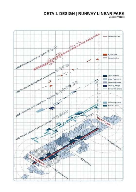
The project proposes a new framework for water management in future PLAB, which is more than blue infrastructure, but a whole new system linking ecological restoration, historical memory, and community life. The design is divided into three strategies:

1. Improvement in rainwater harvesting capacity: Integrating the blue-green infrastructure network through constructed wetland system and WSUD elements
2. Interaction between people and water: Integrating blue infrastructure with community life & historical representation & ecological education in the linear runway park
3. Innovation in water treatment: Introducing decentralized wastewater treatment coupled with on-site, nonpotable water harvesting and purification devices
By integrating the fragmented blue-green infrastructure to create a new blue-green network for the overall studio masterplan, the project enables the efficient management of water reuse and achieves the goal of resilience. While it tends to transform water management infrastructure into spatial landmarks to reconnect the relationship between humans and water, which echoes the studio’s goal of a happy model town.


FROM RICE TO RISE:
Agropolitan Revitalization Strategy for mixed-use innovative rice development

Location: Jakata,Indonesia
Type: Academic / Group Work (Hu Die, Zhang Yuer, Shen Yunnan, Jin Zhuoyin)
Duration: 2021.08-2021.12
Tutor: Jessica Ann Diehl
The landscape design of Seed Town aims to create a harmonious and productive environment that supports innovative and ecologically diverse rice production methods while promoting community integration and economic growth.
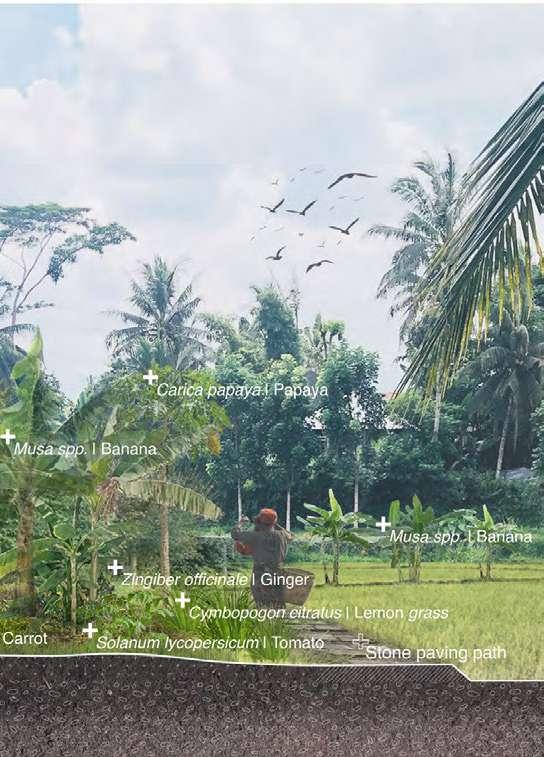
The project focuses on using different rice production methods to increase rice production and introducing a research base to extend the rice chain. The traditional pesticide-dependent rice production in the seed town will change into an innovative and ecologically diverse rice production model. The new mix-use community will attract people from different social classes to live here and promote community integration and economic growth. The leisure and tourism nodes interspersed with the working and living spaces improve the quality of life for the residents and serve as a sightseeing trail for agricultural students and researchers.
The design will respect the local cultural and historical context, with materials, colors, and forms that reflect the vernacular architecture and landscape.
Overall, the landscape design of Seed Town will improve the quality of life for residents, attract people from different social classes, promote the regional economy, and enhance the farming community's culture and identity.


TURN ‘COVERED’ TO ‘HOME’:
Landscape Enhancement of Covered Linkway and Their Surrounding Spaces In HDB


Location: Singapore
Type: Academic Indivitual Work
Duration: 2021.08-2021.12

Tutor: Mel Yip
Covered linkways have played a crucial role in Singapore's urban infrastructure by providing a convenient and sheltered means of transportation for commuters. However, their uniform design and lack of connectivity to surrounding public spaces have limited their potential as vibrant social spaces within the community.
This project seeks to unlock the full potential of covered linkways by exploring creative ways to enhance their connectivity and transform them into blue-green infrastructure. By integrating landscape improvements and promoting informal social interactions, covered linkways can become a transformative force that elevates public housing communities from being merely ‘liveable’ to being ‘lovable.’

Ultimately, this initiative aims to create a more inclusive and cohesive community by fostering a greater sense of belonging and pride in public housing estates.


01
THE WAY HOME FOR OYSTER: Revival of Shajing
Area: 596.7ha
Location: Shajing, Shenzhen
Type: Academic /Teamwork
Roles in the team: Leader
(Pre-analysis, Idea proposal, Strategy analysis, Scheme design, Plan drawing, 3D modeling, Simulation Experiment, Strategic Analysis, Construction drawing, Renderings, Physical modeling)
Duration: 2020.04-2020.08
Colaborator: Wei Dai Yuming Lu
Instructor: Zixu Qiao
Oysters of Shajing, the specialty of Shenzhen's Shajing, has a thousand-year history. However, due to urbanization, water pollution and the disruption of the ecological balance of the wetlands, the cultivation of oysters has moved out of Shajing. In 2005, Oysters of Shajing were selected as an intangible cultural heritage, and the search for a way to return to their hometown began.
Through the restoration of the ecology,the water pollution can be controlled to restore the mangroves and the memory of oyster farming on the site should be restored.

>1000 mg/L & >2 problem of water pollution is sea eutrophication and excessive heavy metals, which affect mangrove growth and manhole oyster farming.
+68%
After 1978, the process of urbanization caused serious water pollution, and land reclamation also led to a large reduction of mangroves.
-70%
The core mangrove forests have been reduced by 70%, and the reduction of wetlands has disrupted the ecological balance of the coast and seriously affected the pollution purification capacity of the coast.
Shenzhen has now grown from a small fishing village to a highly developed mega-city in China. However, due to urbanization, Shenzhen has lost the cultural memory of the fishing villages it once had.
Dongguan
EMIGRATION
Shajing Town has history of 1,000 years of breeding, and urbanization pollution has caused the relocation of Shajing oyster breeding industry.

DECLINE OF BIOGENIC COAST IN THE PEARL RIVER ESTUARY

The total length of the coastline has been increasing since 1978, mainly because of large amount of construction of the artificial coast.
Meanwhile, mud-deposition coast and biogenic coast have been disappearing gradually.
Dongguan Shajing
Shenzhen China
As the length of biogenic coastline dwindles, the area of mangrove wetland is inevit-ably declining, from 3831.2 hm² to 1159.6 hm².
The area of mangrove wetland across the Pearl River Estuary have been reduced by nearly 70 per cent
Kong
Shenzhen Hong2 Oyster of Shajing Cultural Exhibition
3 Mangrove Wetlands
4 Public Green Space
5 Floating Islands
6 Oyster-hatching Zone
7 Oyster-growing Zone
8 Oyster-fatting Zone
ECOLOGICAL CYCLE SYSTEM CREATED BY THREE STRATEGIES
The management of water pollution is divided into three parts:
The first part is through the topographic undulation to slow down the flow velocity, settling part of the water pollution;

The second part is mangroves and sedimentation ponds, through ecological oxygenation and other water pollution control;

The third part is oyster farming, further biological management to stabilize the state of water pollution.
The current river flows directly into the sea
Breaking up the river
Let the river flow into the purification zone
Fixed net
The shaping of the terrain balances cut and fill on-site while slowing the flow of water and acting as a purifying agent. The use of grids to secure oyster shells to the surface of the terrain enhances the purification effect.
STRATEGY 1: TOPOGRAPHIC PURIFICATION


The test of the settling capacity of four texture of terrain. In the CFD simulation, the texture Ⅳ slowed down the flow the most, and the settlement could be the most.The results were also verified by physical experiments.


CFD Simulation

Physical Experiments

STRATEGY 2: MANGROVE WETLANDS

Mangrove wetlands are the second stage of purification, where heavy metals are purified from the water primarily through biology. Plant selection was carried out through an analysis of the ability of native species to purify the five major heavy metals present in the Maozhou River.
The flowering season of wetland plants is concentrated from April to September, and the wetlands can present different scenery throughout the seasons due to temperature and tidal influences.
STRATEGY 3: OYSTER FARMING
1.Oyster shells are used as fillings for the stacked topography.
2.Roots Strengthen The Soil.
3. The microorganisms in the mangrove ecosystem provide nutrients for the oyster farming.

4.Seaweed is provided as feed to the oyster farming.
"Spliting Oyster and Oyster Shell" Game Visiting Oyster Farming
BBQ Visit the Shajing Oyster Cultural Exhibition Hall Visiting the wetland Oyster Meal
Camping
Oyster-Fatting Area
Oyster Restaurant
Oyster-Growing Area
Oyster-hatching Area
ACTIVATION OF SHANGHAI PEOPLE'S SQUARE: Based on Automatic Driving Revolution


Area: 14.75ha
Location: Shanghai,China
Type: Workshop /Teamwork


Duration: 2020.06-2020.07

Colaborator: Yixing Wang

Roles in the team: Pre-analysis, Idea proposal, Strategy analysis, Scheme design, Plan drawing, 3D modeling, Renderings

Instructor: Zhicheng Liu
Under the requirements for the trial implementation of automatic driving activities in Shanghai, public space should respond to the changing demand in 2050 when the automatic driving plan is fully implemented.
By rebuilding the circulation system and integrating the functional space, the underground parking lot, which might be abandoned, becomes a more convenient and more multifunctional area for human activities. This design practice is also an attempt to step further into the future and activate the urban grey space through landscape approaches.

The underground entrance of the garage was determinded accourding to the traffic line. The pedestrain accesses are established to avoid traffic on the ground floor. Part of the first basement outdoor space serves as an extension of the museum’s functions. The second basement underground is a main space for sports and entertainment.

FUNCTION LAYOUT LANDFORM The


want to go downstairs to see the art exhibition!
Other cultural relics preserved in the museum can be seen underground!
like to skate here with my friends on weekends!
My children can learn about many shade tolerant plants here.
am
We
after going
SOUNDSCAPE: Modernity vs History, City vs Nature


Area: 6.8 ha
Location: Nanjing, JiangSu
Type: Academic/Indivitual Work
Duration: 2019.10-2018.12
Instructor: Yichun Lu
With a history of more than 2500 years, Nanjing is a charming city combining history and inter-national style. However, due to the rapid expansion of the city, many unattractive public spaces have appeared in Nanjing. These spaces have lost their cultural characteristicsand are plagued by problems caused by urbanization, such as noise and space fragmentation...
The site is just a public space plagued by traffic noise. It is located beside the Nanjing Moat—Qinhuai River. Looking back on the historical sound of Qinhuai, tried to redesign the site through soundscapes, evoke the memories of the venue and provide a more pleasant urban public space for the surrounding people.

 Central ramp with outdoor cafe and show
Central staircase Small outside theater
Automatic car station
Central ramp with outdoor cafe and show
Central staircase Small outside theater
Automatic car station
In ancient times, the banks of the Qinhuai River were rich in sound, with the sounds of nature, oars, singers, theatres and markets forming a nice soundscape. Man and nature living together on the banks of the Qinhuai River, and the beauty of Qinhuai and the customs of Nanjing are superimposed here.


The Sound of Nature The Sound of Oar The Sound of Showgirls The Sound of Drama The Sound of Market
Park suffers from noise disturbance.
People need space to contemplate. need a comfortable walk everday.
We have nowhere to play
It's too noisy to play cards here
Residential areas
Church School
Residential areas


SITE

Qinghuai river
The Noise Prediction Model: CRTN
LA10,1hr=10log10 (Q)+33log10 (V+40+ 500/V)+10log10 (1+ 5P/ V)+0.3G-26.6
LA10, 1hr The arithmetic mean noise level in dB(A) exceeded for 10% in one hour

Q: Traffic volume (1hr)

V: Traffic speed (km/h)
P: Fleet composition (percentage of heavy vehicles)

G: Road gradient (percentage)
Q: 4000~6000 (rush hours)
V: 60~80 km/h
1 Topograic Noise Reduction Zones
2 Water Pools
3 Market Square
4 Sport Space
5 Activity Lawn
6 Music Stairs
7 Waterfront Terraces
8 Waterfront Walkway
9 Interactive Paddle Zones
SOUNDSCAPE MAPPING
ZONE A: Voice of Reflection
Due to the absorption and scattering of the topography, the overhead noise turns to background sound, while sounds of birds and wind in the natural landscape function as the keynote sound. A stroll here also help people think about the relationship between nature and city.
ZONE B: Voice of Life
The sound of children playing in the water pool and people chatting in the market square create the vibrant sound environment every day. Just as the sound of theatre along the Qinhuai River in the history, here is the new urban stage.
ZONE C: Voice of History
Sound of Traffic
Sound of Qinhuai river
Sound of bubble fountain
Sound of nature/leaf rusting
Sound of children
Sound of Qinhuai flute
Sound of Oar
Sound of Weekend Market
ZONING & STREAMLINE ANALYSIS

Transform the sounds of history into musical steps, interactive paddles and other installations, add waterfront walkways and let people look back on history in an entertaining waterfront experience.

ZONE C: Voice of History
ZONE A: Voice of Reflection
ZONE B: Voice of Life
ZONE C: Voice of History
Greenway route

Waterfront route
Playing route

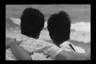
BETWEEN CENTER AND EDGE: For Crystal Boys
Area: 1.21ha
Location: Taipei,Taiwan
Type: Academic ndividual Work

Duration: 2020.01-2020.03
Instructor: Jing Qian
The site, located next to the 228 park in the heart of Taipei’s old town, was designed to commemorate the legalization of homosexuality in Taiwan. 228 park in the years when homosexuality was illegal, witnessed violence and exclusion, but also a shelter for 50 years of love, desire and warmth. Although located in the center of the city, the gay erotic space here is like a dark kingdom, excluded from the world around it. Same-sex marriage was legalized in Taiwan in 2019, but barriers and prejudices remain.

The design is based on the novel CRYSTAL BOYS (about gay love in the 228 park), to commemorate the history and success of the gay movement, and also hope that one day, the world belongs to everyone, where people do not need to distinguish between gay or gay space, only then, equality will truly come.
Schools

SPACE TRANSLATION
Foreign Office Dating Place Detail Station Dating Place
The site is located next to the 228 Peace Memorial Park in Taipei, Taiwan. Since the 228 Peace Memorial Park was one of the main gathering places for gay men in Taipei, homosexuality occupy different positions in the park, and they also have a sense of domain control to varying degrees. This project analyzes the novel “Crystal Boys” by Taiwan writer Bai Xianyong, and aims to establish a mentality of the gay community and the history of the Taiwan gay movement. This is just to commemorate the legalization of gay Taiwan in 2019.

Public Attitude to Homosexuality in Taiwan
Wanted!
Society Acceptance of Homosexuality in Taiwan
Heterosexuality Home sexuality 85% 15% Normal Abnormal Neutral Positive Negative Neutral Opposition Neutral Support 43% 46% 11% 68% 12% 20% 1992 1993 2015 Gays Citizens Officers
Increasing Society Acceptance of Homosexuality in Taiwan
ESCAPE WEAKNESSS BE HOSTILED CAGE SCARE
DARK KINDOM
published this book in 1983. We want to be the same as you! can marry you!
1908 1950s-1970s 1983 1997 2003 2019


228 Peace Memorial Park was established.
Gay men started to date here.
During martial law, homosexuality was outlawed.Because of the police chase, the gay community can only date in the dark.


Bai xianyong wrote the gay novel Crystal Boys based on the park. Strengthened homosexuals ’sense of belonging and identification with the park“ Home forever ”.
“Changde Street Incident”: More than 40 gay men were forced to back to The police station by polices. Park turned to be a black zone.

Taiwan’s first pride parade was held on November 1st, starting on 228 Peace Memorial Park.
Taiwan legalized Same-sex Marriage.
Excerpt 1:
Excerpt 2: It’s always like this. Do you think the outside world is limitless?

Excerpt 3:
Excerpt 4:
The threat from that boundless universe outside can been keenly felt at any moment in our kingdom.
In the dim light of the reddish moon above we look like a pack of sleepwalkers, frantically stepping on each other’s shadows as we skirt the lotus pond, never stopping, round and round in crazed pursuit of that nightmare of love and lust

We stand equally on the stairs of the lotus pond. No matter whether we are innocent or pure or battered and depraved, our footprints are all left in this kingdom, leaving one page of indelible history on the bank of the lotus pond
ATION PA STRUGGLE RETURN
Escaping light and entering dark sadly. Pain, helpless, and escaping from

Sketch Of Scene
Shots Light In Space Space Rhythm Flow Sketch of Section DARK KINDOM SRTUGGLE RETURN PEACEFUL


EXCURSIONS IN THE PARK
01. The shadowed space enclosed by the walls is a metaphor for the ‘dark kingdom’ of homosexuals only, a zone of isolation from mainstream society. The interlocking and tightly packed walls represent the walls in the minds of homosexuals who have been expelled from society.

02. Cutting into the terrain, the paths leading to the outside world represent the inner struggle of the homosexuals themselves. The end of the path is closed and people eventually return to the main path, just as homosexuals struggle to escape but eventually return to their hearts.
04. The gloomy space is suddenly broken by beams of light falling from the sky, guiding one upwards. This is a metaphor for the coming light of the struggle of homosexuals.
03. As the space continues to sink, the visitor comes to the end of the main pathway a dark circular shape with water spilling over the low part of the floor. The visitor is guided by the raised topography, around the circular space to the staircase. Here is the climax of the space, suggesting the unquenchable love of the homosexuals.
05. The mirrored pool reflects the bustling centre of Taipei and the water lilies in the pool symbolise equality. People are harmonious but different, and homosexuals will eventually be accepted by society and reap peace of mind.
06. People descend through the circular walkway onto the grassy slope, where the space becomes free and people can choose any path in the grassy slope to stroll, representing that human nature is no longer bound by social prejudice.


MODEL REFINEMENT
Using oil mud to deduce the topography:


A gently fluctuating topography wraps around a central mirrored pool. Visitors can wander through the undulating topography and eventually return to the starting point, which is a metaphor for human nature. Groups of low walls create intangible pressure that homosexuals have to face. The contrast between the soft ground and the low wall reflects the dilemma that the gay community have to go through.
OTHER WORKS
Central Steel Park and Surrounding Area
Landscape Design Competition


Location: Shanghai, China
Type: Internship Work at SWA Group (Historical Heritages Analysising, Cyberpunk Park Detail Design, Road Design, Smart Park Diagrams)
Time: June 2021
Bao Steel Industrual Park Planning and Design


Location: Shanghai, China
Type: Internship Work at Valentien + Valentien (Garden Design, Gallery Design,Autocad Drawing, 3D Modelling)


Time: Nov 2020
8 Shenton Way Location: Singapore
Type: Internship Work at Ramboll Studio Dreiseitl (Water Feature Design,Public Hub Design,Autocad Drawing, 3D Modeling)
Time: June 2022
Dark Kindom Escaping Love & Lust EqualityCentral Steel Park and Surrounding Area Landscape Design Competition


Location: Shanghai, China


Type: Internship Work at SWA Group (Historical Heritages Analysising, Detail Design, Road Design, Smart Park Diagrams)


Time: June 2021

Bao Steel Industrual Park Planning and Design


Location: Shanghai, China
Type: Internship Work at Valentien + Valentien (Garden Design, Gallery Design,Autocad Drawing, 3D Modelling) Nov 2020
For job applicaiton only, copy and right to Valentien + Valentien Before After
8 Shenton Way
Location: Singapore
Type: Internship Work at Valentien + Valentien (Water Feature Design,Public Hub Design,Autocad Drawing, 3D Modeling)


June 2022
For job applicaiton only, copy and right to HL
Tel: