
32 minute read
City of Families


Newark is a City of Families
Newark is a city of families — traditional and nontraditional — putting down roots and thriving.
Goals
1
2
3
4
5 Ensure housing security for Newark families.
Improve the quality of Newark’s building stock.
Enable Newarkers of all ages and abilities to safely move around the city.
Significantly expand Newark's tree canopy to help air quality, heat, and stormwater capture.
Expand access to resources for healthier living.
Policy recommendation with land use implications - see Appendix I
Policy recommendation to advance social and/or environmental justice
4.1
Ensure housing security for Newark families.
Newark is proud to be a city of multigenerational families. The macro-economic investment forces, cost of construction, rising rents and plateauing incomes are making it increasingly difficult for families to stay in the city. The city must strengthen the enforcement of its development agreements and Inclusionary Zoning Ordinance, as well as implement and track the City’s Housing Goals.
*Master Plan Highlight 4.1.1 Operationalize Mayor Baraka's Housing Goals.
Ensure all Newarkers have access to safe, decent, and affordable housing, to ensure that our city continues to be a vibrant gateway to the opportunities of the region for all, regardless of income, race, ethnicity, or immigration status.
We need to make sure the benefits [of redevelopment] serve the people who have stayed in Newark all this time. We cannot let people be pushed out.

-Cynthia, Facebook Live event (Feb 2022)
image: USVO
Mayor Baraka's Housing Goals
1. Add 3,000 new homes across all five wards by 2026; and 8,000 homes by 2032
● Thoughtful zoning changes that increase the permitted density through comprehensive planning process.
● Maximize incentives like tax abatements to facilitate development that would not happen otherwise ● Issue RFPs on city-owned land for development of new homes
● Streamline and digitize the city’s development review process
2. Fund the creation or preservation of 6,600 affordable homes by 2026, prioritizing affordability at or below 30% AMI
● Leverage formerly city-owned property to create affordable units through Redevelopment
Agreements and the Land Bank
● $20M investment in Affordable Newark initiative to fund deeper affordability (30% of AMI and below) ● Increase compliance with the Inclusionary
Zoning Ordinance
● Ramp up rent-control outreach and compliance
● Layer financing from federal, state and city sources to increase the depth of affordability and number of units
3. Convey all city-controlled vacant properties by 2026, with at least 30% affordable units
● Redevelop and sell properties through the land bank
● Require maximum affordability in all redevelopment agreements ● Auction properties where development of affordable housing isn’t feasible
4. Support 1,500 new and 200 existing low- and moderate-income homeowners by 2026
● Section 8 Homeownership program
● Live Newark closing costs and employee assistance grants
● Live Local homeownership program
● Move-in Ready program ● Pro Newark/Resident Advantage program
● Live Newark façade improvement program
● Self Sufficiency Program
● Financial and homeownership counseling from partner organizations
5. Support 10,000 vulnerable or unsheltered households annually by 2026
● Promote rent control compliance
● Disburse federal emergency rental assistance funds
● Provide temporary and transitional housing ● Provide supportive services to special populations
● Provide legal services to tenants at risk of eviction through OTLS
● Counseling from partner organizations
NEWARK CELEBRATION
Newark's Section 8 Homeownership Conversion
The Section 8 Homeownership Program is funded by the U.S. Department of Housing and Urban Development (HUD). In Newark, main focus is on investing in existing neighborhoods, using local MWBE contractors and helping build community wealth for Newarkers. Along with Invest Newark, the City uses properties that were transferred from the Department of Economic and Housing Development to the Newark Land Bank to help first time homebuyers complete their purchase using Section 8 vouchers. In addition, Invest Newark provides funds for development costs which create more equity for homeowners and create local construction jobs. Through a lottery process, to date the City of Newark has successfully supported 8 eligible families to become homeowners through this program.
Policy Pivot
The Model Neighborhood Initiative program in the West Ward coordinated activities for development and made land available to local developers for the creation of housing. The City could launch a similar program in more Wards to concentrate Housing Trust Fund grantmaking and providing low-cost land to local minority developers.
4.1.2 Provide widespread resources to promote homeownership and expand first time homebuyer programs.
Live Newark’s “Home Closing Cost Program” provides down payment and/or closing cost assistance for the purchase of an owner-occupied residential property. These zero interest loans are forgiven if the resident continues to occupy the residence for 5 years after the loan has closed.
Expand Newark’s Section 8 Homeownership Conversion program. This program brings together Invest Newark, Newark Housing Authority, and the City of Newark to convert Section 8 rental vouchers into homeownership vouchers via the redevelopment of abandoned public property.
KEY RECOMMENDATIONS
● Expand Newark’s Section 8 Homeownership
Conversion program
● Expand the Model Neighborhood Initiative (MNI) to other priority neighborhoods that are in end of affordable housing and investment
4.1.3 Include bigger housing units in new developments to accommodate large families of different cultures.
While the need for affordable housing is severe and widespread, a study by Rutgers CLiME shows that the need is more profound for 2+ bedroom units. For developments that receive public subsidy, a minimum of 30% of total units should be designed and built for large bedroom units (2+ bedrooms).
KEY RECOMMENDATIONS
● Reserve a minimum of 30% of total units for large bedroom units (2+ bedrooms)
Affordable housing is a cornerstone of an equitable, fair community.

-Stacy, Facebook Live event (Feb 2022)
Market Value & Displacement Risk
High Pressure Strong Market Middle Market Weak Market
Stable Area
Lagging Market
FIGUrE 83 2022 Market Value Analysis and Displacement Risk Ratio (DRR) Source. The Reinvestment Fund, City of Newark
Market Value Analysis (MVA) can help identify strengths and weaknesses in residential real estate markets. Displacement Risk Ratio (DRR) data helps to measure housing stress by analyzing affordability for long-term residents. When MVA data is cross-referenced with DDR, zones of the highest vulnerability to displacement (shown here in deep orange) can be identified and prioritized.
4.2
Improve the quality of Newark’s building stock.
To further uphold the pillar of strong Newark families, we must improve the quality of Newark’s building stock which is some of the oldest and most outdated in the state and can contribute to the detriment of population health – impeding pursuit of household wealth.
4.2.1 Implement a facade improvement program and promote the reuse of vacant neighborhood storefronts for entrepreneurs and small-scale makers.
Many of Newark’s commercial/cultural corridors were struggling before the COVID-19 pandemic. Towards the resilience of Newark neighborhoods, we must rethink goals for these corridors – prioritizing wealth building, expedient tenancy, remote work, and cultural retention.
Live Newark (administered by Newark Alliance) includes a home façade improvement program designed to create a sense of pride of ownership, preserve/Increase the value of residential properties, and beautify neighborhoods. It provides up to $20,000 no-interest forgivable loans for owneroccupied homes. The loans may be used for repairs or improvements to the property’s exterior which are intended to beautify the community and may also satisfy code violations or threats to the health, safety and welfare of the occupants or the surrounding community. Over a five-year period, 20 percent of the loan is forgiven for each full year in which the recipient has lived in the home. The City of Newark should explore a façade improvement program for small businesses to improve the appearance of its commercial corridors – leveraging recently acquired ARPA dollars and future funding sources. Additionally Newark’s Live Local program provides one-year incentive for eligible participants to renovate homes in a designated program incentive area. For example, NJIT provides up to a $3,000 allowance to qualifying employees/residents towards the cost of housing, and eligible homeowners can receive up to $7,000 from the Newark Alliance for approved exterior improvements to their primary residence.
KEY RECOMMENDATIONS
● Explore a façade improvement program for small businesses to improve the appearance of its commercial corridors
4.2.2 Address vacancy and blight by expanding the city’s vacant building ordinance.
Currently Newark requires all foreclosed and vacant properties to register with the Department of Economic and Housing Development (EHD). Expanding this ordinance to include vacant storefronts (partial vacancy) will incentivize property owners to activate street life and increase funding for EHD to implement targeted enforcement.
KEY RECOMMENDATIONS
● Expand the vacant property registry to include vacant storefronts (partial vacancy)
4.2.3 Incentivize retrofits of existing buildings for energy efficiency, indoor air quality, and lead abatement.
Expand the Live Newark program to include energy efficiency, indoor air quality, and lead abatement grants to owner-occupied homes. Additionally, include green roofs, smart rain barrels, and greening where possible to conserve water and improve building energy efficiency. The city of Newark should work with key partner organizations, including utilities and the Department of Health & Community Wellness and its partners to streamline public education and leverage resources available to different sectors providing “green and healthy homes” and related services. Activities may include the development of a single online portal that aggregates information regarding local, state and federal opportunities to lower residential/commercial energy and water bills, as well as ameliorate health and safety concerns in older buildings. In doing so, we hope to ensure increased access to funding and financing programs related to energy and water conservation, energy efficiency, alternative/ distributed energy, contamination reduction, and relevant equipment upgrades & replacement programs.

We should turn our abandoned properties into affordable housing.
4.2.4 Expand home weatherization program, including target outreach to eligible property owners.
Expand the Live Newark program to administer New Jersey Department of Community Affairs Weatherization Assistance Program in home weatherization grants to qualifying Newark households. Financial grants are provided to lowincome households, community-based agencies, and elderly to weatherize their homes, improving their heating system efficiency and conserving energy. Additionally, the city should require partial or complete air conditioning as requirement for building inspections / certificate of occupancy sign off.
image: Cesar Melgar
"We need to invest in building the capacities of our families to support young learners."
-Community Workshop (May-June 2022)
"In the future, Newark is a city where transportation is fast and reliable, green space is abundant and accessible to all, housing is green and affordable, infrastructure is resilient and resourceefficient, healthy food is available and the sense of community is strong."

South Orange Avenue reimagined
South Orange Avenue in the West Ward is a major connector from Downtown through some of Newark's most populated neighborhoods, with heavy through-traffic limiting walkability.
Traffic calming with narrower streets and robust crosswalks, and streetscape greening with trees and stormwater infrastructure, will help nearby families feel more safe and comfortable to walk along South Orange Ave and cross safely on their way to nearby schools, parks, recreation centers, and shopping districts.
Nearby residential areas could receive home weatherization improvements and possibly even increase density with Accessory Dwelling Units, while infill mixed-use development can help provide additional housing opportunities for Newark's growing and diverse population.
HOME WEATHERIZATION
MIXED USE INFILL
HOMEOWNERSHIP OPPORTUNITIES
FRESH FOOD ACCESS
BLUE/GREEN ROOFS
YOUTH-CENTRIC SPACES
POCKET PARK DEVELOPMENT
STORMWATER INFRASTRUCTURE

FIGUrE 84 S Orange Ave today Source. Nearmap
I'd love more buses to ride up South Orange Ave, with benches and coverings at bus stops and dedicated seats or even a separate shuttle for seniors.
-West Ward Community Workshop (June 2022)
4.3
Enable Newarkers of all ages and abilities to safely move around the city.
Safer streets in Newark should begin with a Vision Zero plan, focus on problematic intersections, promote alternative modes of transportation, and protect school-age children.
*Master Plan Highlight
4.3.1 Create, adopt, implement, and enforce a Vision Zero policy and plan.
Vision Zero is a global approach to transportation that establishes the goal of achieving zero fatalities on roadways – making human life the priority rather than vehicular throughput. The 2016 City of Newark Pedestrian and Bicycle Safety Action Plan set a short-term goal of adopting a Vision Zero policy. In addition, the action plan recommended the creation of a Transportation Safety Committee that includes representatives from city government, community groups, the business community, colleges, Essex County, NJDOT, and the NJTPA. The goal of this committee is to advocate, guide, and provide recommendations.
Enacting a Vision Zero policy provides an avenue for funding as well as a driver for ensuring the development of a plan and subsequent roadway improvements. A Vision Zero plan creates a roadmap for the city to address safety issues on its roadways, and typically includes a toolbox to aid in quick design and implementation of various safety elements.
An annual citywide Vision Zero report helps keep track of progress – both in terms of implementing actions and in terms of tracking their effectiveness. Many Vision Zero policies are low cost, and Newark has already done a lot of the work to prepare for the implementation of a Vision Zero Action Plan. In 2016, the city completed the Newark Complete Streets Design Guidelines and Implementation Plan. While this isn’t a Vision Zero Action Plan, it does contain many relevant elements. The Compete Streets Plan contains detailed design guidelines for pedestrians, bicycles, roadway and vehicles, streetside features, and intersections.
Developing a Vision Zero Action Plan is a crucial component of making Newark’s streets safer and can be largely completed by pulling together and updating work already done by and for the city. Between 2016 and 2021, 7,153 people were injured on Newark’s roads. Vulnerable road users – pedestrians and cyclists – made up 1,018 of these. No Newarkers health and safety should be forfeit to the transportation system. Vision Zero will help create a safer future on Newark’s roads.
KEY RECOMMENDATIONS
● Develop and adopt a Vision Zero policy and action plan for Newark
● Implement and monitor the Vision Zero action plan
NATIONAL CASE STUDY

image: One Architecture & Urbanism
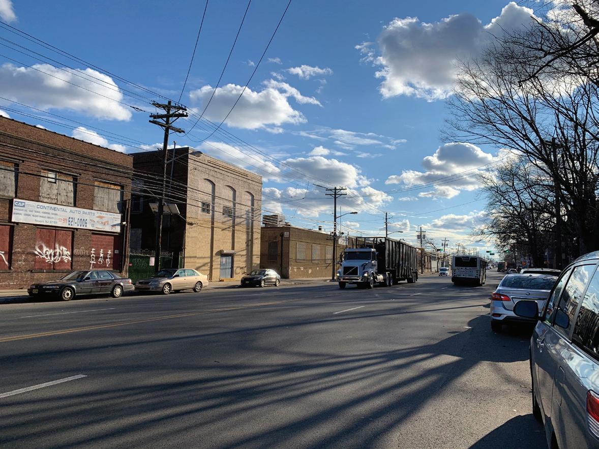
Wide streets with fast traffic and trucks are treacherous for pedestrian crossing image: Jersey City Vision Zero Action Plan
Jersey City's streets undergoing a Vision Zero initiative
Jersey City Vision Zero
In 2018, Jersey City adopted a Vision Zero initiative and created a Vision Zero Task Force to draft an action plan. The Task Force is made up of transportation officials, public safety officers, and members of the public, and the Vision Zero Action Plan aims to eliminate traffic-related death and serious injuries on Jersey City streets by 2026. In 2019, the Action Plan was adopted by Jersey City Municipal Council Resolution and sets for 77 specific actions that act as a blueprint for reaching traffic safety goals.
By 2020, Jersey City had advanced or completed 58% of the Actions set forth in the plan. In that same time, the city has seen a 43% reduction in pedestrian fatalities from 2018.

Pedestrian & Bicycle Safety Action Plan
The 2016 Pedestrian and Bicycle Safety Action Plan used data from 2009-2013 to identify the top 10 high crash intersections for pedestrians and cyclists within Newark:
1. Broad Street and Market Street
2. Market Street and Mulberry Street
3. Bergen Street and 12th Avenue
4. Ferry Street and Monroe Street
5. Raymond Boulevard and Raymond Plaza East
6. Walnut Street and McWhorter Street
7. Ferry Street and Adams Street
8. Raymond Boulevard and Mulberry Street
9. 7th Avenue and Colonnade Place
10. Market Street and Raymond Plaza East
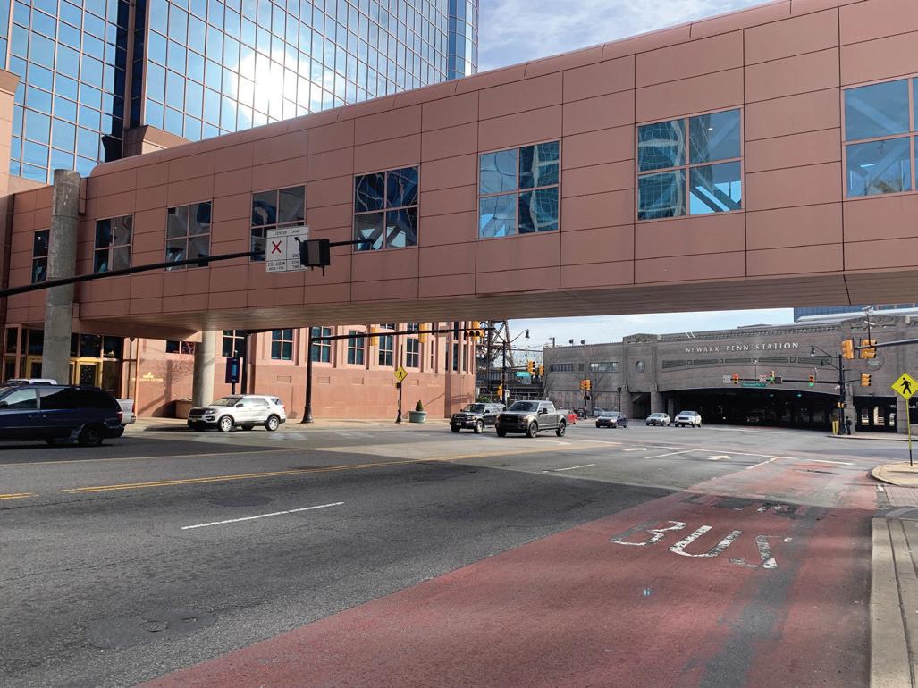
The focus on pedestrians and cyclists is because they are the most vulnerable users of any roadway. If we can make things safer for the most vulnerable users, then the roadway becomes safer for everybody.
Market Street at Penn Station is an unsafe and uncomfortable streetscape environment, despite being a major point of entry into the city
4.3.2 Implement interventions on intersections that have the most fatalities.
Intersections are the most common places for collisions, and subsequent injuries and deaths, to occur. This is because intersections present drivers with the largest number of decisions while at the same time putting them in conflict with the greatest number of other roadway users. Decisions take up mental energy, reducing a driver’s ability to anticipate, notice, and react to other users. Conflict points are where the pathway of roadway users overlap. The three key solutions to increasing safety are:
● Reduce the number of decisions roadway users need to make;
● Reduce the number of conflict points;
● Reduce speeds to minimize damage, with the knowledge that there will be collisions due to unavoidable decisions and conflict points.
Road Safety Audits (RSAs) should be conducted at high crash intersections on a regular basis, as well as at intersections that are identified as unsafe by communities. RSAs are formal safety examinations of intersections by an independent, multidisciplinary team. The team uses their expertise to qualitatively estimate and report on potential road safety issues and identify opportunities for improvements in safety for all road users.
KEY RECOMMENDATIONS
● Conduct RSAs at the top 10 high crash intersections, and other intersections identified by communities as dangerous
● Implement safety measures in accordance with findings from the RSAs (the Newark Complete Streets Plan can be used for design guidance)
The roads are not safe. Install speed bumps and ban large trucks in my neighborhood.

-Participant at South Ward Community Workshop (May 2022)
Key Safety Issue Points
Dangerous Local Roads
High Crash Intersections
FIGUrE 85 Key Safety Intersections Source. City of Newark, Arup
The highest crash intersections tend to be clustered around Penn Station, but the top dangerous local roads are spread throughout the city, largely in the South, Central, and West Wards. Targeting these areas for road safety audits can help identify specific improvements to make first to ensure fewer fatalities for drivers, pedestrians, and cyclists.
*Master Plan Highlight 4.3.3 Implement and enforce Complete Streets projects on major corridors.
Newark’s major corridors are the lifeblood of the city, allowing people to travel between neighborhoods and providing locations for local businesses to thrive. Safety, mobility, comfort, and beauty need to be prioritized along these corridors, and complete streets strategies are the best method to do this.
Complete Streets are designed to ensure that people of all ages and ability can safely move along and across streets in a community, regardless of how they are traveling. A complete street can include space for bikes, bus lanes, bus shelters, trees, parklets, scooter corrals, outdoor dining, school crossings, and other features that make streets accessible and livable.
Often, the width of a roadway is the limiting factor for implementing complete streets. Each element of the roadway, and each user group (driver, pedestrian, cyclist, bus rider), needs sufficient space to be able to function correctly. Roadways in Newark should be inventoried to determine what roads could be pilots of complete streets based on their widths.
Another way to determine which roads to pilot complete streets on is safety. The following corridors are the top 12 corridors where deaths occur on City of Newark roadways, and are recommended corridors to pilot complete streets treatments on:
● Broad Street
● 1st Street
● Court Street
● Elizabeth Avenue
● Avon Avenue
● Raymond Boulevard ● Ferry Street
● Clinton Avenue
● 14th Avenue
● Hawthorne Avenue
● Spruce Street
● Bergen Street
Complete streets use design strategies to ensure people of all ages and abilities can safely move along and across streets in a community, regardless of how they are traveling. A complete street includes space for bikes, bus only lanes, full bus shelters, scooter corrals, outdoor dining, street trees, and many other features that make streets more accessible and livable.
Newark Complete Streets
The 2016 Newark Complete Streets Design Guidelines and Implementation Plan is a ready-made resource for providing the kind of roadway upgrades the city needs. The Design Guidelines were developed after the City of Newark formally adopted a Complete Streets Policy in 2012.
Bergen Street is a good example of a potential pilot for complete streets in Newark. From Lyons Avenue to Renner Avenue, Bergen Street is lined with businesses and homes. It is also home to two bus lines, Route 39 and Route 99, and provides a north/south link for bicyclists to access the city without traveling into the central business district. This road is over 50 feet wide, but only provides space for cars. There are few stop lights or signs to reduce the speed of vehicles traveling along the roadway, and high speeds are only further encouraged by the wide roadway. At the intersections with traffic lights, there are rarely pedestrian signals provided. All of these improvements could be made through a complete streets pilot project.
KEY RECOMMENDATIONS
● Implement complete streets measures along the 10 high crash corridors listed
● Identify areas with high pedestrian activity or significant community safety concerns for complete streets implementation
● Implement complete streets around transportation hubs, schools, transit stops, and business corridors
● Identify roadways within Newark that could serve as complete street pilots based on their width

Newark's streets need to be designed for pedestrians, bus riders, and cyclists, not just cars
*Master Plan Highlight 4.3.4 Expand bike lane network for Newarkers to increase equitable access to alternative modes.
Newark’s bike network provides North/South connectivity via Irvine Turner Boulevard and Norfolk Street. However, Newark lacks adequate connected and protected bike lanes to meet bike demand throughout the city, especially for East/ West connections. Cycling has a demonstrated positive impact on health, equity, the economy, and other aspects of daily life. Beyond cycling, bike lanes provide safe infrastructure for other modes of active mobility like electric scooters, wheelchairs, and other wheeled or motorized forms of individual transport.
An expanded bike network provides an alternative to the car and the bus that is critical for low-income Newarkers, non-car owners, and children who need to safely move around the city. Bike+Ironbound provides a toolkit of possible bike facilities that can be implemented around the city. Many bike facilities are low cost, and can be easily piloted with a set of traffic cones or some paint.
The proposed network of Bike+Ironbound is a perfect start for determining which streets should have bike infrastructure, and should subsequently be expanded to incorporate the entire city. Data from the Bike and Scooter share program also provides an excellent starting point for determining where bike infrastructure is most immediately needed. Cross city corridors such as Springfield Avenue, South Orange Avenue, Market Street, Clifton Street, Bergen Street, Irvine Turner Boulevard, Clinton Avenue, and Bloomfield Avenue have immediate demand for safe and consistent bike infrastructure.
Bike priority corridors should differ from transit and pedestrian priority corridors. This ensures that the benefits of safe streets are spread out between many corridors, and also reduces the conflicts between vulnerable roadway users.
KEY RECOMMENDATIONS
● Expand the Bike+Ironbound plan to incorporate the whole city
● Create a connected citywide bike network with special focus on East/West connections
● Develop a citywide bike infrastructure implementation plan to guide the funding and installation of a bike network
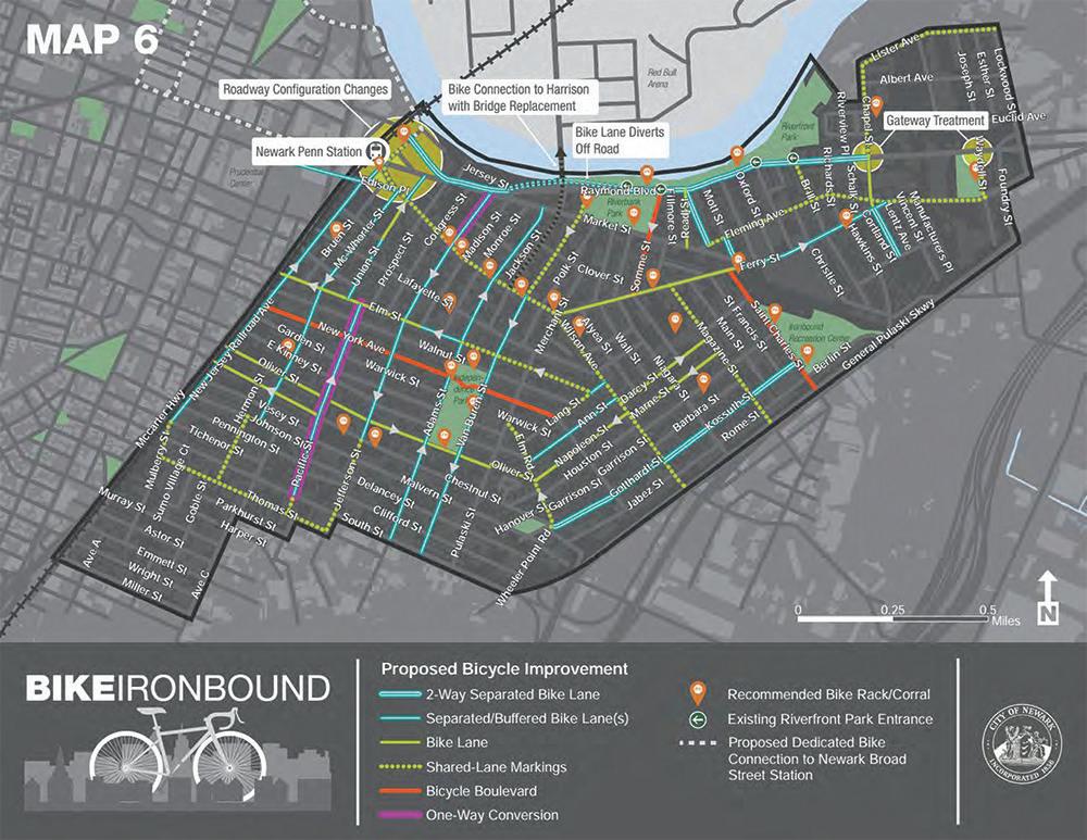
Bike+Ironbound Plan

Potential Bike Network
Existing Bike Lanes
Proposed Bike Infrastructure
FIGUrE 86 Potential Bike Network
Source. City of Newark, Arup
Proposed Bike Infrastructure can take many forms - depending on roadway geometry, vehicle volumes, and traffic speeds. Protected bike lanes, shared bus/bike lanes, and bike boulevards are all acceptable forms of bike infrastructure.
The proposed roadways shown are examples of how to fill in the network and create robust connections throughout the city. These are based on cyclist volume data, and have not gone through a robust design process. A bike network plan should be created to ensure the proposed roadways are suitable for bike infrastructure.
4.3.5 Address safe routes to schools and parks with focus on pedestrians safety and ADA access.
Safe routes to schools are perhaps the most important element of a safe roadway network. Newark’s children are also Newark’s future, and their safety is paramount to the health and growth of the city. Strategies to reduce the risk to children must be rolled out in the quarter-mile radius surrounding schools. The quarter-mile radius is chosen because it represents an approximately 5-minute walking time, and creates a safe buffer around a school for drivers and pedestrians to become aware of their surroundings and reduce speeds. It is recommended that Newark implement a Safe Routes to School program using the “6 E’s” framework to identify needs and structure goals and activities. The “6 E’s” are engagement, equity, engineering, encouragement, education, and evaluation. Equity considerations are important when developing safe routes to schools programs. Programs should address health disparities and power imbalances that lead to generational economic, education, and health hardships. Ensuring safe routes to schools initiatives benefit all demographic groups, with particular attention to creating safe, healthy, and fair outcomes for low-income students and students of color, will begin to repair generational injustices.
KEY RECOMMENDATIONS
● Reduce speed limits by 10 mph around schools
● Implement safe crossings for a quarter mile around schools
● Implement traffic calming strategies for a quarter mile around schools

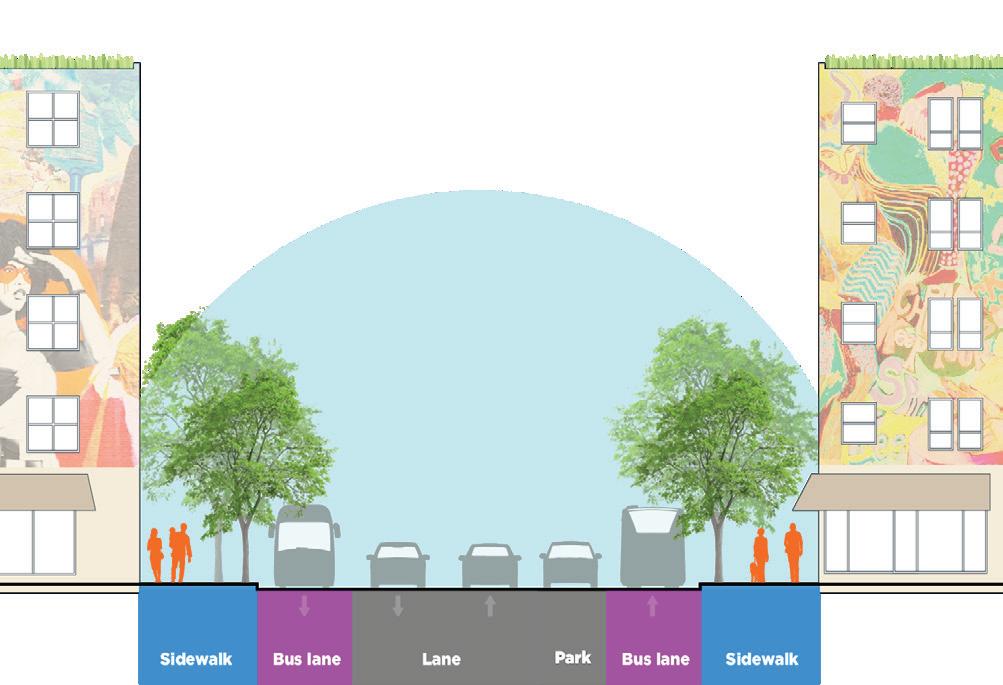
Existing streets in Newark tend to have wide travel lanes and street parking on either side, but could be retrofitted in any of the following configurations for safe & multimodal functions Option 1: Dedicated Bus Lanes
Safe Route Partnership
Safe Route Partnership provides the following best practices for engineering improvements that can be made to roadways:
● Reduced speed limits – reduced speed limits exponentially increase the chances of a pedestrian surviving a collision with a driver. A reduction of just 10 mph can increase the chance of survival 50-75%
● High visibility signs – high visibility signs at crosswalks alert drivers to the potential of pedestrians, especially children, crossing the road. Equipping signs with flashing lights provides even more visibility
● Pedestrian signals (HAWK) – pedestrian signals stop traffic to expressly prioritize the movement of pedestrians. HAWK signals are only activated when a pedestrian is waiting to cross, allowing traffic to continue uninterrupted otherwise
● Elevated crosswalks – elevated crosswalks raise the visual prominence of pedestrians and force drivers to slow down when entering and exiting an intersection
● Speed humps – speed humps maintain low speeds between intersections by causing discomfort and potential damage to vehicles if driven over at high speeds
● Truck routes – truck routes should never pass through a school zone. Trucks have unique visibility problems and an inability to stop on short notice, as well as significant noise and air pollution concerns
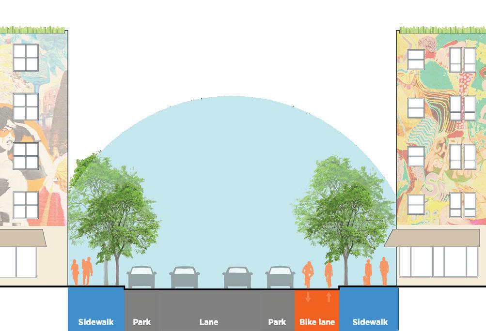
Option 2: Dedicated Bike Lanes Option 3: Parklets/Green Infrastructure

Potential Streetscape Retrofits:
Sidewalk Bike Lane
Bus lane Parklet Parking Area
Travel Lane
4.4
Significantly expand Newark's tree canopy to help air quality, heat, and stormwater capture.
Improving air quality requires a combination of local initiatives and state- or even region-wide coordination to address sources of pollution and ramp up efforts to mitigate and filter pollutants. While the most effective strategy is to eliminate pollution generation at the source, measures such as strategic land use planning, expanded landscape buffers between highways and neighborhoods, and citywide greening efforts can all contribute to a healthier outdoor environment for Newarkers.
*Master Plan Highlight
4.4.1 Develop and support a citywide tree planting initiative.
Stewarding a robust tree canopy for Newark is a multi-decade process that requires planning, buy-in, coordination, and maintenance to ensure success over the long term. Street trees thrive when they are given adequate space to establish and grow, are protected from soil compaction, and cared for with regular pruning and maintenance. This demands collaboration of city agencies, utility staff and contractors who work in the right of way, and citizens to care for and nurture over time. Given the existing gaps and limitations in the tree canopy [Newark tree cover = 7.9% vs. Essex County 40.3%], multiple initiatives are needed to effect citywide change, including establishing priority areas for planting, expanding planting requirements for new development, creating design standards for tree planting, and developing a list of preferred tree species which considers criteria such as canopy structure / robustness, climate resilience as Newark warms, and longevity. At the same time, interagency coordination and enforcement is key to protect the existing canopy, ensure any tree removals are replaced in kind, and ensure regular pruning and maintenance. The Department of Public Works will develop a criteria for street tree removals.
The creation of a citizen pruner training program can enable more residents to participate in care of the tree canopy without unique approvals from the department, while the creation of local tree nurseries can ensure a supply for generations to come.
KEY RECOMMENDATIONS
● Develop city-wide tree planting initiative
● Design an inter-agency review and enforcement process for street tree planting and maintenance
● Create a citizen pruner training program
● Conduct an urban heat island and tree canopy analysis in order to determine priority locations and feasibility of planting. Build capacity for tree planting and care.
Policy Pivot

There are few items more indemand in the city than trees in the neighborhoods – they provide shade, reduce heat and beautify streets. However, their planting and maintenance require steady funding and operations. A study and additional capacity in the Sustainability Office to manage the Tree Fund and maintain plantings across Newark should be implemented in a deliberate way based on a study that can indicate priority areas.
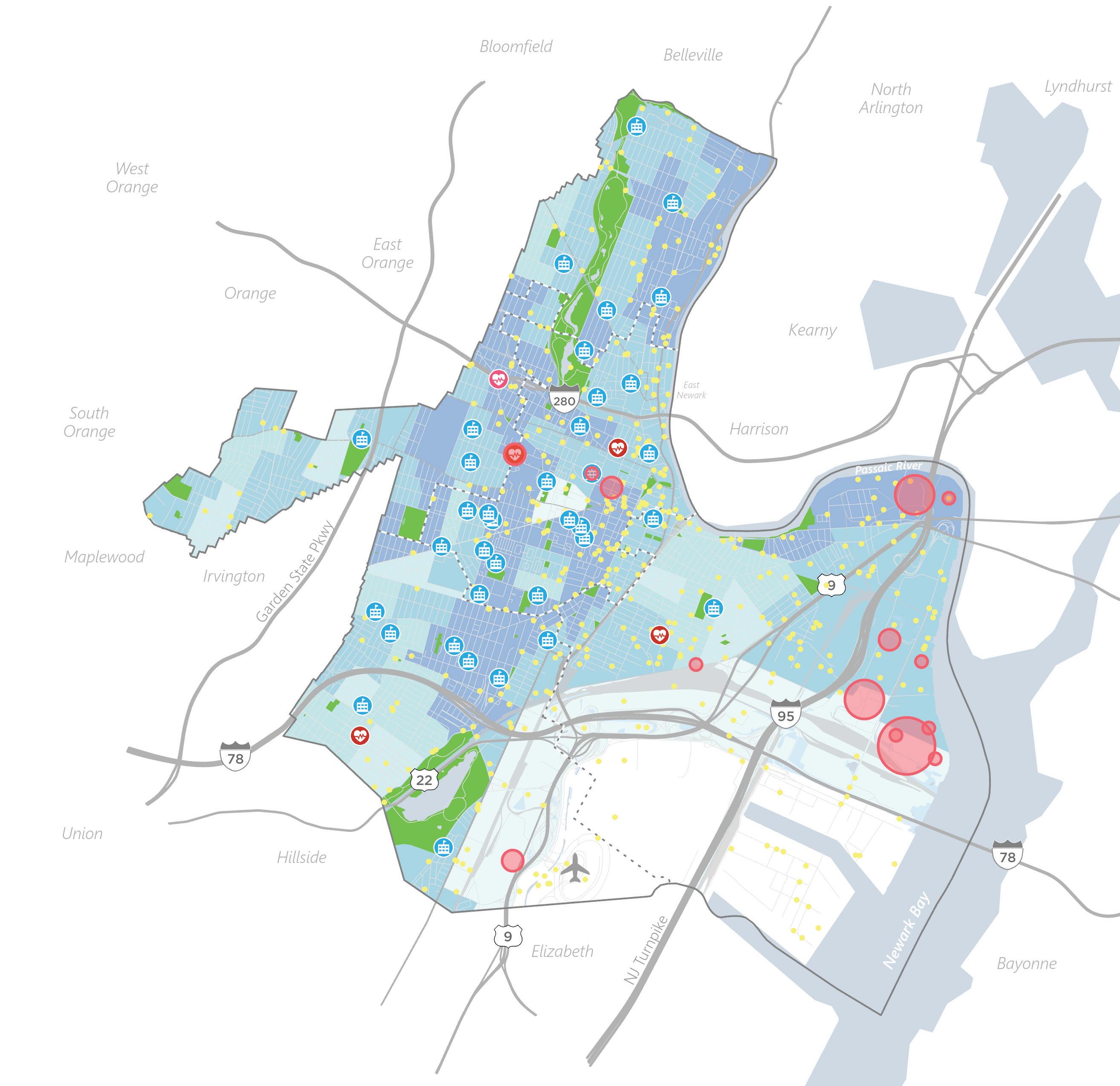
Critical infrastructure and Vulnerability Areas
Childcare Centers
Schools
Hospital-Medical Centers Polluting Infrastructure Socially Vulnerable Areas of High Heat and Lack of Access to Green Areas
Areas of No Access to Green Space Air Quality Buffer for Highways
Tree Canopy
FIGUrE 87 Citywide Tree Planting Priority Zones Source. City of Newark, State of New Jersey Social Vulnerability Index, ONE Architecture & Urbanism
Industrial areas and heavy polluters like highways are often in close proximity to vulnerable assets like schools, hospitals, and child care centers. A concerted citywide tree planting initiative and other air quality improvement initiatives can help buffer these effects, especially along highways and in the most socially vulnerable neighborhoods.
4.4.2 Create landscape buffers to protect communities from highways and sources of pollution.
Regional transportation corridors are essential to move people and goods but are at the same time a significant burden and threat on the communities that surround them, as well as a major source of greenhouse gas emissions. While I-78 in the South Ward has trees planted along its edges, most Newark highways cut directly through neighborhoods with limited if any buffer for trees. Planted buffers with trees and shrubs filter and reduce airborne pollutants, lower surrounding air temperature, improve health outcomes and community livability, and reduce highway noise. These buffers are even more critical in areas where schools are located near highways and outdoor play areas are directly impacted by vehicular emissions.
4.4.3 Identify and mitigate point source pollution from heavy industry and energy infrastructure.
Newark’s energy generation, sewer, port, and airport facilities and infrastructure drive the economy of the whole region but disproportionately burden Newark residents with pollution and air quality impacts. They are also the core of an industrial cluster that produces minor air quality impacts across the city and region. In addition to collaboration with state and federal partners to regulate and limit sources of pollution, the city should incentivize air quality improvements through a mix of economic incentives such as subsidies, fees, and standards that encourage polluters to reduce emissions.
image: Sasaki
Landscape buffers can not only help with air quality from pollution, but also create public assets like Wilmington Park at the Port of Los Angeles, which buffers industrial uses while also creating important public recreation space.

Legend
Levels of CO2 Emissions Annually
More than 1,000,000
250,000 - 1,000,000
100,000 - 250,000
10,000 - 100,000
Less than 10,000 Social Vulnerability Index 0.95-1 (high)
0.85-0.95
0.75-0.85
0.65-0.75
<0.65 (Moderate)
FIGUrE 88 Annual CO2 Facilities Emissions (1000 tons / year) Source. NJDEP, ATSDR / CDC, NJGIN
Almost all of Newark has high social vulnerability; however, some particularly vulnerable populations reside in close proximity to heavy CO2 emitters like power generating stations and other infrastructure. Additional heavy emission industries should be restricted from siting near these zones of vulnerability.
4.5
Expand access to resources for healthier living.
Newark facilities and businesses enable efficient food distribution across the whole region, yet many of these businesses are in areas close to the Port of Newark that face climate risks from coastal and rainfall flooding – or along transportation corridors that are similarly vulnerable to inundation. regional food security depends on the resilience of the Newark-based distribution network. Creating opportunities for a decentralized, citizen-grown food network can support the goal of making fresh fruits and vegetables both accessible and affordable to a broader subset of Newarkers while advancing many of Newark’s climate goals, from reducing transportation requirements to contributing to carbon sequestration to reducing urban heat island and stormwater flooding. In the face of a changing climate, local food production can help ensure more Newarkers remain food secure when shocks disrupt the global supply chain.
Additionally, a smaller neighborhood network of community healthcare facilities can help local access, enabling every Newarker to have a health center close to home.
4.5.1 Designate and support urban agriculture zones within each ward.
Urban farming and community gardens have a rich history in Newark as spaces of affordable food production and community connection and development. Expanding the network of communityled gardens and farms can find opportunity at multiple scales, from the installation of a few raised beds in residual open space at community facilities and schools up to the transformation of vacant lots for productive use. Newark has more than 2,500 vacant lots, many of which exist in parts of the city that currently lack open space. The State’s Green Acres program offers a valuable source of funding to secure open space and create recreational assets, which can include community gardens. Green Acres funding ensures protection of open space in perpetuity. Meanwhile, installing food production gardens in schoolyards is a starting point to incorporate food literacy into school curricula, reactivate unused spaces, create opportunities to green schoolyards, and contribute to nourishing school lunches.
KEY RECOMMENDATIONS
● Expand the network of community led gardens and farms
● Install food production gardens in schoolyards
We need more CSAs (Community Supported Agriculture) and education on them and the value of our own backyard farms.
-Participant, West Ward Community Workshop (June 2022)
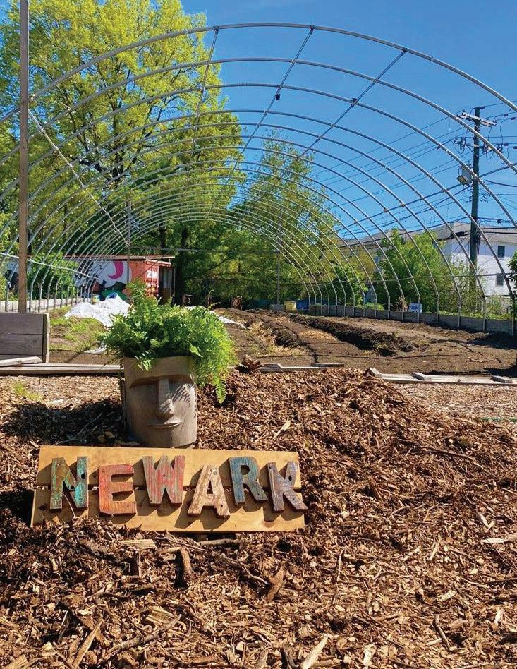
IMAGE Down Bottom Farm
4.5.2 Create and incentivize neighborhoodbased fresh food access/grocery stores.
As the pandemic has made clear, local access to fresh food and groceries contributes to neighborhood and family health. Especially in a city where more than one in three households does not own a car, food deserts and access to fresh food more generally can represent a major challenge. Expanded commercial zoning and the creation of overlay districts for fresh food businesses can help facilitate the expansion of grocery stores to underserved neighborhoods by offering incentives such as increased density or decreased parking requirements for developments that include grocery-related businesses. In addition, mobile food vending programs like New York City’s Green Cart initiative create pathways toward licensing and deploying vendors to sell whole fruits and vegetables in hard-to-reach parts of the city.

4.5.3 Create and incentivize neighborhoodbased health clinics.
The pandemic has also taught us the importance of accessible neighborhood healthcare facilities and pharmacies (testing, vaccination centers, etc.). The city currently operates six federally qualified health centers. Land use changes will facilitate the development of additional community health centers so that every Newarker is within a 15-minute walk of accessible, life-saving healthcare.
image: City of Newark image: City of Newark

Key Pillar Actions:
● Add 3,000 new homes across all five wards by 2026; and 8,000 homes by 2032
● Fund the creation or preservation of 6,600 affordable homes by 2026, prioritizing affordability at or below 30% AMI
● Convey all city-controlled vacant properties by 2026, with at least 30% affordable units
● Support 1,500 new and 200 existing low- and moderateincome homeowners by 2026
● Support 10,000 vulnerable or unsheltered households* annually by 2026
● Expand Newark’s Section 8 Homeownership
Conversion program
● Expand the Model Neighborhood Initiative (MNI) to other priority neighborhoods that are in end of affordable housing and investment
● Reserve a minimum of 30% of total units for large bedroom units (2+ bedrooms) ● Explore a façade improvement program for small businesses to improve the appearance of its commercial corridors
● Expand the vacant property registry to include vacant storefronts (partial vacancy)
● Develop and adopt a Vision Zero policy and action plan for Newark
● Implement and monitor the Vision Zero action plan
● Conduct RSAs at the top 10 high crash intersections, and other intersections identified by communities as dangerous
● Implement safety measures in accordance with findings from the RSAs (the Newark Complete Streets
Plan can be used for design guidance)
● Implement complete streets measures along the 10 high crash corridors listed
● Identify areas with high pedestrian activity or significant community safety concerns for complete streets implementation
● Implement complete streets around transportation hubs, schools, transit stops, and business corridors
● Identify roadways within Newark that could serve as complete street pilots based on their width
● Expand the Bike+Ironbound plan to incorporate the whole city
● Create a connected citywide bike network with special focus on East/West connections
● Develop a citywide bike infrastructure implementation plan to guide the funding and installation of a bike network
● Reduce speed limits by 10 mph around schools
● Implement safe crossings for a quarter mile around schools
● Implement traffic calming strategies for a quarter mile around schools ● Develop city-wide tree planting initiative
● Design an inter-agency review and enforcement process for street tree planting and maintenance
● Create a citizen pruner training program
● Conduct an urban heat island and tree canopy analysis in order to determine priority locations and feasibility of planting. Build capacity for tree planting and care.
● Expand the network of community led gardens and farms
● Install food production gardens in schoolyards


