
22 minute read
Graphisoft thinks BIG
Among recent BIG design wins is The Spiral, a new New York City high rise, with garden terraces the entire height of the building
Graphisoft thinks BIG to move BIM forward
With the launch of ArchiCAD 20, Randall S Newton visited Graphisoft’s HQ in Budapest to hear how fresh thinking and a powerful partnership are shaping the company’s approach to open BIM and collaboration
Graphisoft, the maker of ArchiCAD, is a division of the larger Nemetschek Group, which recorded record revenue of €285.3 million in 2015, up 30% on the previous year.
The newest version of ArchiCAD is now out and offers some great new features (see article on page 25 for more details), but to listen to Graphisoft vice president for Europe, Andras Haidekker, you would think that the company faces major challenges. Of course it does — but no more than any other forward-looking software company in this market.
Graphisoft’s leadership team knows that, in order stay relevant, the company has to move BIM forward, not just as a modelling system, but also as an information management system. That’s a challenge when almost half of your potential audience are still scratching their heads and only just starting to think about maybe trying this new BIM thing.
With its new ability to work with Rhino data, and additional new features relating to import and use of metadata, Graphisoft says it’s on a mission to put the ‘I’ in BIM.
“Information is power,” ArchiCAD implementation team leader Tibor Szolnoki told me on a recent day-long visit to Graphisoft’s headquarters in Budapest. “Information is an asset architects can sell.”
The ‘M’ in BIM, meanwhile, is now about management, not models, as I heard several executives say on my trip to Hungary.
To put it another way, Graphisoft executives believe that few architects are using the information management capabilities of either BIM or the open IFC construction data model. “Between the desktop and the mindset, there is a big gap,” says Szolnoki. Increased mandates from government for IFC-compliant documentation is changing things, but it isn’t just customer reluctance that Graphisoft needs to tackle. It also has to sell its customers on new workflows.
Power of partnership Here, Graphisoft believes it has found a great partner in Bjarke Ingels Group (BIG), a progressive architecture firm with headquarters in Copenhagen and a major office in New York. BIG prides itself on being ‘edgy’ in its technology choices and design instincts. Its principals talk of ‘sustainable hedonism’ as a guiding philosophy.
The secret to effortless BIM

Sitedesk simply makes BIM manageable
Total control and visibility are critical when you’re running a BIM project. Juggling data and shuffling paper are the last things you need. The simplicity and ease of use of Sitedesk makes BIM almost effortless. Collaboration becomes faster and easier, in the office or on site.
Sitedesk offers practical, easy-to-deploy 3D collaboration software for contractors, owners and operators to help drive efficiency, reduce the cost and risks of construction, simplify the creation and handover of digital asset information and ensure compliance with BIM.
View and manage designs, models and documents

Use digital forms to accelerate project workflows
Replace paper processes and create an audit trail
Capture, annotate, attach information, photos and video
Work anywhere on standard-spec IT kit
One-click COBie data handover and digital O&M manuals

2

1 The new live link logic between Rhino+Grasshopper and ArchiCAD solves the issue of radically different approaches to creating 3D data. Rhino uses NURBS to control curves and define surfaces (top row); ArchiCAD uses polygon meshes to define shapes (bottom row) 2 Unique settings have been created as part of the Rhino+Grasshopper-to-ArchiCAD 20 live link
BIG uses Rhino 3D as its go-to CAD for son, but so was the full information man- More than meets the eye early stage conceptual design. Like other agement package ArchiCAD 20 offers. Full compliance with IFC 4 in ArchiCAD ‘rock star’ architectural firms already “BIG is very design-oriented,” com- 20 opens the door to new, more streamusing Rhino, BIG went nuts over the ments Haidekker. “They wanted to lined workflows to keep information live arrival of Grasshopper, an add-on mod- reduce time on documentation. They see and useful throughout a project. Two ule to Rhino for algorithmic design (also with ArchiCAD for BIM they can work new workflows in particular, Design known as ‘generative design’ or ‘compu- three to four months on concept design Transfer View and Reference View, allow tational design’, depending on which and then create project documentation in architects to work more closely with vendor you speak to, because Bentley and one to two months.” other disciplines while utilising the same Autodesk also offer these tools). Information management drove BIG BIM. They allow custom, discipline-spe-
BIG’s edgy Scandinavians are also into the arms of Graphisoft, and this cific views to be created. The combination shrewd technologists. They saw that seems to have triggered a domino effect. of these new data-oriented workflows their elegant, algorithmic designs were Graphisoft’s dealer network is adding with the new graphical representation being tossed over the proverbial wall to Rhino to its portfolio and BIG’s competi- tools Smart Filters and Graphical the schematics team for complete detail- tors are now looking at ArchiCAD with Favorites (see article on page 25 for more ing in BIM, with no live connection fresh eyes. “We are now invited to com- details) means increased visibility for full between the concept data and the sche- panies who use Rhino,” says Haidekker. data about doors, pumps, curtain walls matics, and knew this needed to and all other manufactured or change. The information link was as broken as if they had delivered their ideas on paper. ‘‘ Graphisoft believes that few architects custom-crafted elements. ArchiCAD 20 also supports the latest iterations of gbXML
Luckily for them, Graphisoft are using the information management (for analysis data) and PHPP had spotted the same problem capabilities of either BIM or the open (Passive House Planning among its existing client base. In 2015, the company started IFC construction data model Package) for exchanging data with engineers and consultants. sharing an early beta release of a live link between Rhino and ’’ To work better with data that is still being stored in those ubiqArchiCAD that could provide two-way “Some big players, the so-called ‘blobby uitous Excel spreadsheets, ArchiCAD 20 data exchange. architects’.” offers Mass Property Value Import, a tool
“They came to us because it was taking Many architects prefer to use best-of- for the semi-automated import/export of too long for their innovative designs to breed ‘point’ tools, as opposed to being data. It isn’t push-a-button yet, but it does become construction documents,” says limited to a single vendor’s product line. remove the tedium of manual entry of Haidekker. Rhino has become the point tool of choice product data into BIM schedules, and
BIG found out, and asked to take part in for initial concept design. McNeel and reduces the inevitable mistakes that this the testing process. To cut a long story Graphisoft worked together closely on process so often introduces. short, BIG’s Copenhagen office is now the implementation of the live link ■ graphisoft.com/ArchiCAD standardising on ArchiCAD 20 as its soft- between Rhino+Grasshopper and ware for schematics and construction ArchiCAD to advance schematic design Randall S. Newton is a business analyst and jourdetailing. The read-write of and construction detailing for their nalist with more than 30 years experience in the Rhino+Grasshopper data was a big rea- mutual clients. AEC and manufacturing design industries.
WIN
A POWERFUL HP WORKSTATION AND DITCH YOUR PC
DEVELOP3D and AEC Magazine have teamed up with AMD FirePro and HP to give you the chance to win one of two powerful workstations, perfect for 3D CAD and BIM. Two lucky winners will take home a HP Z240 SFF desktop workstation or HP ZBook 15u mobile workstation, both powered by AMD FirePro graphics. To be in with a chance of winning one of these fantastic prizes all you need to do is answer a few quick questions at
tinyurl.com/AEC-HP-WIN
The closing date is November 1, 2016. Winners will be drawn at random
&Building Information Modelling (BIM) for Architecture, Engineering and Construction
In association with
ENTER THE COMPETITION AT tinyurl.com/AEC-HP-WIN
Terms and conditions: This competition closes on November 1, 2016 and is open to individuals over the age of 18. Entry into the competition and acceptance of the prize constitutes permission of entrants to use their name inside the magazine. The winner will be selected at random by X3DMedia and announced on DEVELOP3D.com and AECmag.com and in the December / January 2017 edition of DEVELOP3D magazine and the November / December 2016 edition of AEC magazine. No purchase necessary. Only the winner will be contacted personally. X3DMedia is not responsible for lost, late, incomplete, invalid, illegible or misdirected entries.
HP ZBOOK 15u G3 MOBILE WORKSTATION
Unlike a standard business laptop, the HP ZBook 15u mobile workstation is designed specifically to run 2D or 3D CAD software. Armed with a powerful AMD FirePro GPU, the optimised and certified machine offers workstation-class performance and reliability in a highly portable ‘Ultrabook™’ form factor. The sleek and stylish laptop is ideal for design and engineering executives, architects, road warriors and construction professionals

WORTH £990 ex VAT FIRST PRIZE
Find out more about the prizes @ hp.com/uk/D3D
★ AMD FirePro™ W4190M GPU (2GB) ★ Intel® Core™ i7-6500U CPU ★ 15.6” diagonal FHD SVA anti-glare LED-backlit (1920 x 1080) ★ 8GB 2133 DDR4 memory ★ 256GB Z Turbo Drive PCIe ★ Windows 7 Professional 64 (available through downgrade rights from Windows 10 Pro 64) ★ 3 Year warranty
RUNNER UP PRIZE
WORTH £859 ex VAT HP Z240 SFF WORKSTATION

This Small Form Factor (SFF) desktop machine delivers workstation performance and reliability at starting prices that rival desktop PCs. It is 57 percent smaller than the HP Z240 Tower, but still delivers exceptional performance, perfect for 3D CAD and BIM. The included AMD FirePro W4300 GPU is one of the most powerful 3D graphics cards available for a SFF workstation, ideal for even the most complex of BIM models.
Find out more about the prizes @ hp.com/uk/D3D
★ AMD FirePro™ W4300 (4GB) ★ Intel® Core™ i7-6700 CPU ★ 16GB DDR4 memory ★ 256GB Z Turbo Drive PCIe ★ Windows 7 Professional 64 (available through downgrade rights from Windows 10 Pro 64)


Lidar of the pack
The 3D lidar scan is a game-changer for architectural practices. Here, Jacob Down of Poynton Bradbury Wynter Cole Architects draws on the firm’s experiences with the technology to explain why he thinks it will soon become more widespread
Over the last 12 months, there has been a fundamental industry shift in the techniques used by surveyors to capture the spatial volumes and site features of landforms and buildings.
Surveyors are no longer relied upon to judge which site or building features should be measured and recorded. This decision-making process, previously subject to the discretion of a human, has been handed to machines. Human subjectivity is no longer an issue. A passing seagull can now be surveyed with the same precision and accuracy as a downstand beam, thanks to the rise of the 3D lidar scan within architectural practices.
Here at Poynton Bradbury Wynter Cole Architects in the picturesque seaside town of St Ives, far from my architectural upbringing at the Bartlett School of Architecture at University College London, I was fascinated to discover that many local surveying firms now utilise 3D lidar scanning technology. This enables them to capture the spatial data necessary to produce their conventional 2D site topographical and 2D measured building surveys.
Having experienced first-hand the technology in my Bartlett years, I was already familiar not just with the immense accuracy of full-colour HDR point cloud outputs, but also their deeply seductive imagery. I therefore knew that it was only a matter of time before the 3D lidar scan became a key component of our architectural workflows, superseding conventional 2D survey drawings. Rock House remodelled The benefits of utilising the technology were demonstrated at Rock House, a twoand-a-half storey replacement dwelling on Carncrows Rock, deep within St Ives’ conservation area. The design for this project sees a historic north gable retained, with the remainder of the building replaced by a contemporary reinterpretation of the existing one, maintaining its sea views and providing new ones from a mezzanine viewing platform.
A 3D lidar scan was undertaken by CESurveys and used to capture the existing building and immediate surrounding context to forensic levels of accuracy. Most notably, this included the complex geometry of the granite outcrop on which the building was situated; the architectural scars present on the undulating

granite of the north gable; and the sensitive nature and unique characteristics of the conservation area and Grade II-listed cottages immediately adjacent.
By nature of the scanning process, the occupation and the ‘flavour’ of the place were captured and frozen in time as the geometry of the common and banal were captured alongside bricks and mortar. All of this data, captured as a precisely measured set of full-colour or greyscale points in space, can now be digitally revisited, inspected and interrogated remotely at any time in the future.
More conventional surveying techniques would not only have been problematic, but also would have produced drawings of limited use, offering limited information.
The point cloud data generated from the scan, correctly positioned in cartesian space, was issued by the surveyors. Utilising Autodesk Recap 360, the point cloud could then immediately be viewed and interrogated by architects. They could then take dimensions from any point to any point and rotate and view the scene from any angle, internally or externally, enabling them to examine aspects of the site that may have been unattainable in the real-world physical context.
Furthermore, this data was then linked directly into Autodesk Revit, becoming a fundamental point of reference from
Axonometric view of a proposal for the Old Vicarage, a private dwelling also situated in St Ives’ Conservation Area
Contemporary Dormer overlooking landscaped courtyard
Loft Room created with potential ensuite
15m x 4m x 1.2m pool with infinity edge to landscaped courtyard Shared Terrace
Slim framed sliding aluminium glazing system
Slim framed sliding aluminium glazing system. Steel framed 'floating' roof canopy Corner window with sea views aligned with Godrevy Lighthouse over St. Ives Harbour

TRY IT FREE FOR 14 DAYS

Rock House proposal overlaid on 3D lidar scan of the site
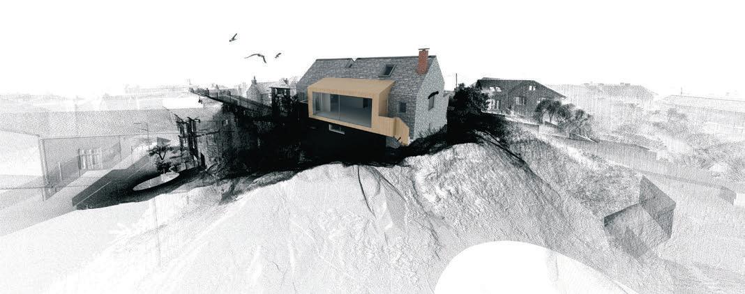
which the proposal was developed. Parts of the existing point cloud were manipulated or omitted within Recap 360, creating multiple variations to meet the project requirements. The end result is a series of point clouds linked into the Revit model, which can be strategically turned on and off to fulfil the purposes or demands of the drawing or BIM model.
Challenging features of the site, such as the complex geometry of the rocky outcrop, the proximity of neighbouring windows with their inherent issues of overlooking and rights to light and the need to maintain the property’s sea views were all examined in plan, section, elevation, 3D axonometric and 3D perspective through the presence of the point cloud.
This enabled the practice to foresee and design out any areas of contention very early on in the design process, resulting in a smooth and successful planning outcome. The point cloud is now informing the technical design and site logistics for the project as it progresses towards a start on site for late autumn.
A dip in the Jubilee Pool Our work on the Jubilee Pool, an Art Deco, Grade II-listed structure situated on the eastern end of Penzance’s promenade, also utilised the 3D scanning technology. The project involved the design of a universally accessible pedestrian route from promenade level to water-entry level, linking a myriad of sweeping curved platforms of varying levels in between.
With the need for Listed Building Consent, the point cloud of the existing was spliced with proposed ramped interventions, providing highly accurate 3D imagery for the client and for obtaining statutory consents.
The key difference of this 3D imagery from the conventional rendered and Photoshop montages more commonly seen in the profession is the geometrical accuracy of the surrounding context. The point cloud freezes the three-dimensional properties of the space to within accuracies of 1mm. This data, combined with the proposal in the same digital space, enables any view or angle of the proposed to be generated in perfect perspective, arming the architect with a powerful tool to confidently illustrate how one’s proposal will sit in its surrounding context, within these given tolerances.
Furthermore, the digital camera can be manoeuvred through the scene in real time, or rendered out as animation, providing viewers with a perspectively perfect parallax experience of the proposed design.
The view from the Old Vicarage A project that explored the potential of the point cloud a step further took place at The Old Vicarage, a private dwelling situated in St. Ives’ Conservation area. The project involved extensive remodelling of the existing building, along with the inclusion of a pool house in a private courtyard to the rear.
Following a 3D lidar scan undertaken by 3DMSI, the existing building was remodelled in Revit through close utilisation of the point cloud. In turn, the architectural proposal was developed from the client’s brief, as well as from the physical site constraints and site opportunities, all of which were captured in the point cloud data.
Although the building was less than 80 metres from the ocean, it struggled to offer any substantial sea views. However, by combining the lidar data of the site and its immediate surrounding context with lidar data captured from the air of the landscapes of St Ives and Godrevy, a landmark vista towards Godrevy Lighthouse over St. Ives Bay and harbour was created from the proposed bedroom extension. This was framed through a glazed corner window and aligned with the summer solstice sunrise when viewed from bed level.
A 6.5km section was drawn, illustrating the line of sight from the bedroom window to the local landmark across St Ives Bay. This was backed up with a digitally generated 3D perspective of the framed vista, demonstrating the landmark’s presence through the tanglement of the town’s fabric from the proposed bed level.
By combining detailed site scans with airborne landscape scans, architects can look to develop truly site-specific architectural responses that capitalise on key views, vistas and site assets at landscape scale. They can also foresee and design out issues around overlooking, overshadowing and rights to light at a forensically intimate scale.
Looking forwards The 3D lidar scan is a game-changer within architectural practice. It presents architects with unprecedented levels of geometric site information, reducing tolerances and margins for error, helping to de-risk projects prior to commencement on site, and opening up huge design opportunities through new levels of accuracy.
As the technology and associated software advances, it is the manipulation of the native point cloud data itself that will prove most valuable, for it is within the points that the accuracy lies. As scanto-BIM applications become more prevalent and refined, moreover, it is only a matter of time before we see widespread adoption of 3D lidar scans throughout the industry.
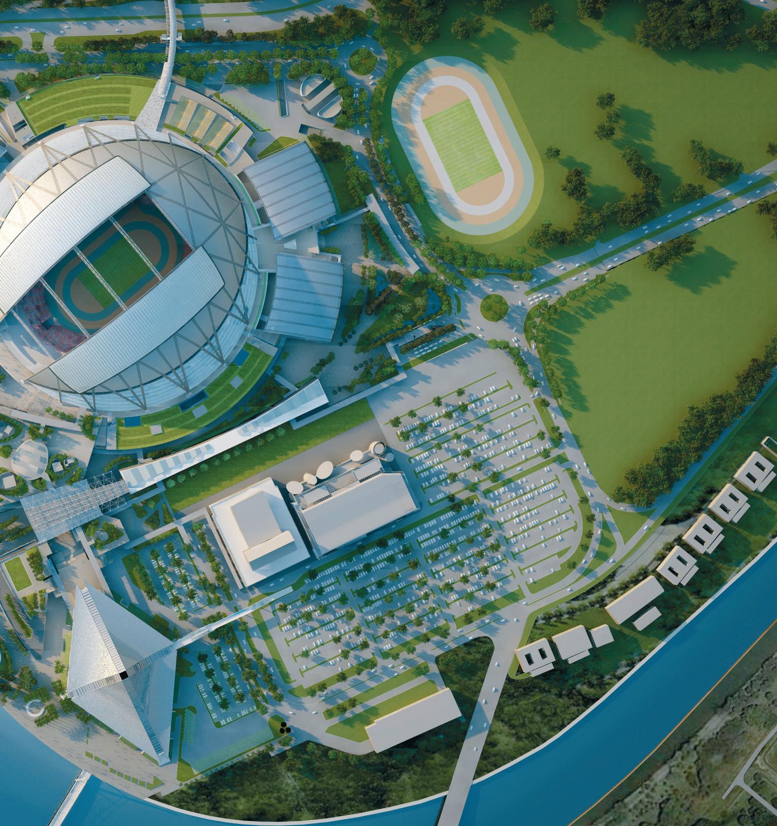
The Singapore Sports Hub development is part of the greater Marina Bay Masterplan

Dome of delight
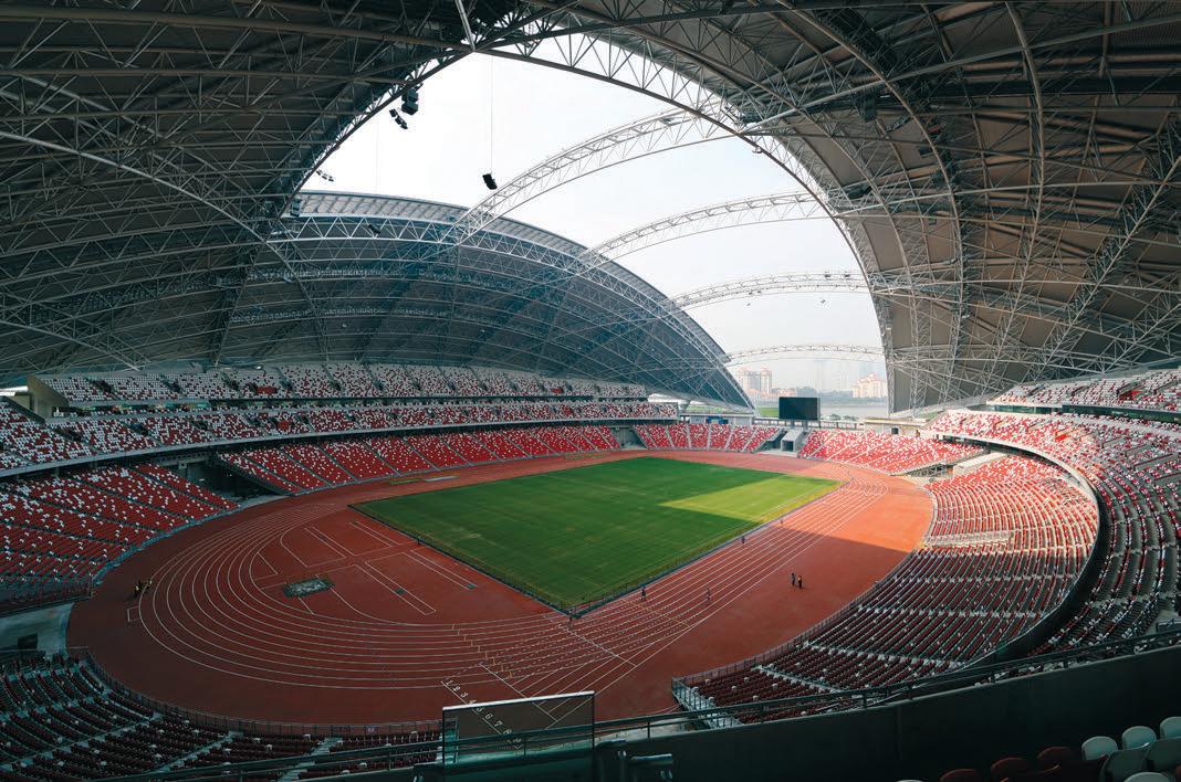
Rising more than 80 metres from the ground, the roof of the Singapore Sports Hub is the world’s largest freespanning dome structure. Here’s how an integrated architectural and structural design approach helped make this ambitious project a reality
Arup’s innovative design for the Singapore Sports Hub, a 55,000-seat national stadium, is a model for future sustainable stadium design, according to the company. The firm was appointed off the back of its track record in creating the Beijing National Stadium, the Allianz Arena in Munich and the UK’s City of Manchester Stadium, as part of the greater Marina Bay Masterplan to reposition Singapore as a great place to work, live and play.
The result was the largest sports infrastructure public/private partnership in the world and, from the outset, achieving
spectator comfort in a tropical climate was a key priority. Arup designed an ultra-thin dome roof structure with a movable roof that extends over the pitch.
This design not only provides shade during events, but also an energy-efficient cooling system that reaches every seat in the stadium, without compromising on the proximity and quality of view for spectators attending everything from sporting events to Singapore’s National Day Parade.
Spanning three football pitches and rising more than 80 metres from the ground, the Singapore Sports Hub roof was constructed from a series of 3D triangular trusses. Fabricated from circular hollow sections, the architecturally appealing curved lines have been exposed in the roof’s structure. These curved lines posed many challenges to the fabricator; however, these were overcome through the use of Tekla software from Trimble.
Emphasis on collaboration The Arup sports venue team used Tekla to optimise the fixed and movable roof design, resulting in an efficient, lightweight and sophisticated form. It recognised from the start that a fully integrated approach to the architectural and structural design would be needed, with a strong emphasis on collaborative design. This, it was hoped, would deliver peace of mind to the architects, main contractors and end users involved, by offering reassurance that the design and products specified weren’t just fit for the job and compliant with various building standards, but also mitigated against the risk of unnecessary costs and disruptions further down the line.
By using specialised, in-house analysis software that was integrated with Tekla BIM through a plug-in, the Arup design
ADVANCED STRUCTURAL ENGINEERING SOFTWARE

As engineers and architects push the boundaries with new creations, Oasys structural software provides you with the tools to effectively analyse and design a wide range of engineering problems including columns, beams, slabs and much more. Our innovative software is continuously developing to meet ever changing requirements so you can work quickly, efficiently and to the highest degree of accuracy.
GSA
Structural engineers working on buildings, bridges and tensile structures need a comprehensive design program - GSA is the right solution.
AdSec

AdSec is ideal for tasks such as analysing a bridge beam for cracking under load, designing a composite mega column, checking a prestressed floor or finding the capacity of a pile.
ADC

ADC allows engineers to analyse and design concrete beams, columns, slabs and piles to various design codes.
Download your free 30 day trial from our site today COMPOS
Compos is a unique composite beam analysis and design software program, which can also perform induced vibration analysis for regular composite floors.
The design of the dome roof structure delivers shade and energy-efficient cooling to 55,000 spectator seats
team was able to update the Tekla 3D And in order to ensure that the design Lightweight, low carbon model automatically to match the latest team’s intentions were fully reflected in One of the key challenges of the Sports version of the design geometry – some- the Tekla model, representatives of Hub project was keeping the roof structhing that might not have been possible Yongnam, the steel contractor in the pro- ture’s weight as low as possible, not just using traditional solutions. ject, developed a system that checked all to reduce costs but also the project’s car-
Sharing model data throughout this the essential data in this model against bon footprint. The biggest load on a roof project was central to its success, so that the design data for each and every inter- like this tends to be the weight of the steel all parties could collaborate on building secting node. structure itself – and this was minimised services, the concrete structure work and Says Mike King: “They [Yongnam] by a process of fine-tuning the design. architecture. Arup was able to catch also used the model to develop the erec- “We like Tekla software for these potential clashes between types of structures, as it is a building services and building structure early and rectify its design. For example, ‘‘ We knew that if we did our documentation solution that steel fabricators are comfortable using and have confidence in,” says approximately 42km of pre- using Tekla, we could hand that model Mike King. “Therefore, we cast terrace seating had to fit over to any steel fabricator in the world knew that if we did our docutogether perfectly with building services such as HVAC. “For this steel project, it was and they would be able to utilise it to develop their own fabrication model mentation using Tekla, we could hand that model over to any steel fabricator in the critical that we used Tekla software, because it was part of the design tool to develop the geometry and tion sequences: how they would bring ’’ world and they would be able to utilise it to develop their own fabrication model, which ultiefficiencies of the roof structure,” says Mike elements on site; what size of elements mately saves time.” King, a principal at Arup’s Singapore office they could fabricate on site; and what And as well as saving time, using a and structural leader of the Sports Hub size of elements would be lifted by the model-based approach for this project project. cranes. The Tekla BIM model was criti- enabled Arup to achieve resource effi-
As the 3D model by Arup defined the cal in all of those phases.” ciencies and, in particular, a reduction geometry and member sizes of the roof It was also used by the cladding con- in the quantities of steel needed — a structure, it was important to ensure that tractors to develop an installation plan more intelligent way of working for eveall connection design information was and to ensure that their systems fitted ryone involved. properly imported into the base model. within the structure. ■ tekla.com


