9 minute read
GIS meets BIM


Esri: GIS meets BIM
AEC Magazine talked with Marc Goldman, director AEC Industry Solutions at Esri about how the company is working with BIM developers to better integrate GIS for AEC professionals
AEC Magazine: Why should your average architect be interested in GIS?
Marc Goldman: In my short stint as a designer (I can’t call myself an architect or engineer because I don’t have licences nor ever did) I recall the challenge of putting my first line on paper or screen. Having geographic context allows you to overcome that inertia, provides you with greater understanding, brings insights to the surface, and allows designs and engineered projects to begin with the most amount of valuable information to be accessed, managed, and used for decision-making.
AEC: Revit is a key application for readers of AEC Magazine. On a technical level, how does ArcGIS work with Revit data – both in terms of geometry and attributes?
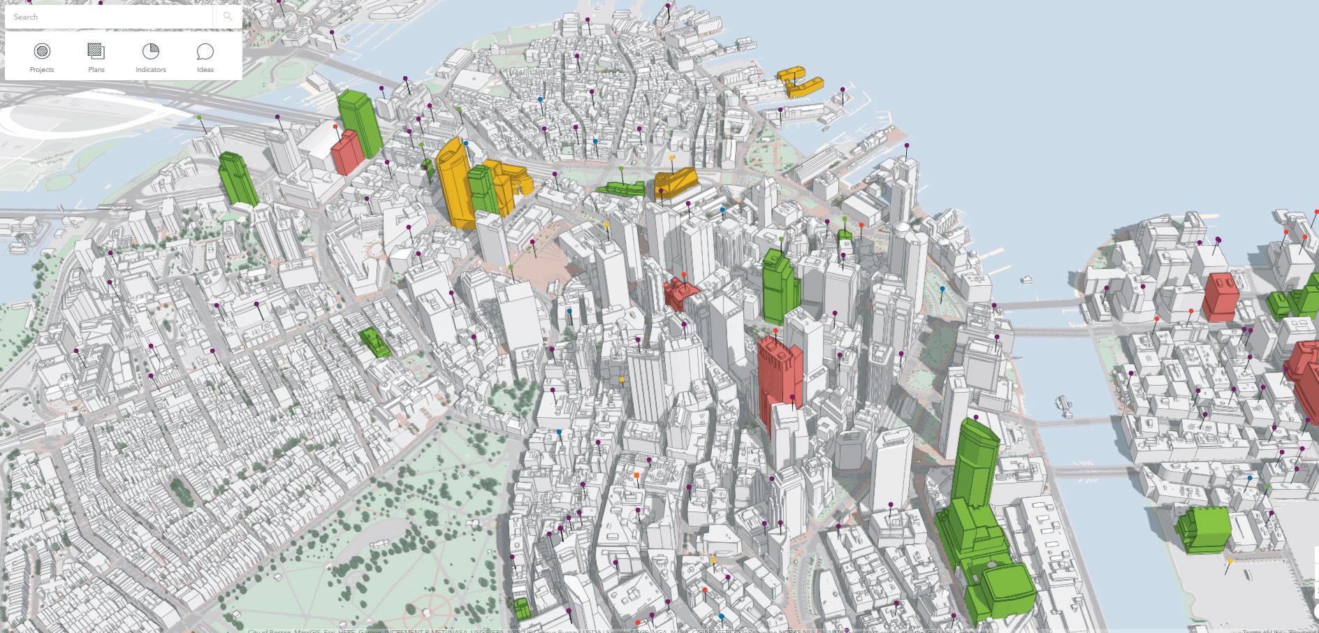
MG: In ArcGIS Pro we can import RVTs, store the geometry and attributes in a geodatabase that captures some of the semantics of the Revit file, and then use the geometry and attributes in GIS workflows, such as by converting them to I3S Building Scene Layers that can be streamed over the web to mobile and desktop experiences. Autodesk’s desktop applications to MG: Let me first talk about civil BIM and ArcGIS. But the real prize comes from then get onto the “building” BIM side. cloud — connecting Esri ArcGIS and On the civil BIM side, within [AutoCAD] Autodesk BIM 360. What’s Civil 3D and Infraworks, the latest on this and why engineers have access to the is it so important to AEC layers and data you’d use or firms? manage in ArcGIS Pro, or which you’d visualise and MG: We’re working on a interact in ArcGIS Online. cloud-to-cloud integration One benefit is streamlining which will allow GIS workflows, so as data is coldashboards, maps and lected in the field with Esri analysis to be performed field-based apps, that data using any files and data in appears in real time on the BIM 360, and from other cloud environments. This ‘cloud to cloud’ communi‘‘ We’re experts in engineer’s desktop in Civil 3D or Infraworks. As to improving quality, cation, whereby the data using distributed in Civil 3D and Infraworks in either cloud is accessible to users in browsers and mobile apps, opens to processing and deep learning for you have access to the GIS data layers to better understand the project’s condoor to workflows we’ve object detection, straints. All this means only dreamed of in the classification, individuals and teams can AEC industry. AEC: Esri previously told terrain analysis, and change make informed design and engineering decisions by visualising collaboratively, us that BIM / GIS integra- detection on the Infrastructure and GIS tion isn’t just about giving any scale data directly. BIM models a GIS context, it’s also about giving AEC Marc Goldman Looking at Building BIM, once the BIM (RVT or firms access to Esri services. Can you explain more ’’ IFC) has been imported to ArcGIS Pro, the informaabout these services and how AEC firms tion is managed like other geodatabase or can benefit? And what are the challeng- shapefile data sources. This allows the es of big data? BIM objects themselves to be understood
visually - sliced and diced on screen.
Users can tap into the properties of the BIM objects and of the project itself, getting deeper understandings than any “viewer” and easier than any modelling app. Architects, engineers, contractors and owners collaborate with a common view into the intelligence which can be gleaned from the BIM.
The challenges of ‘Big Data’ for any AEC industry technology provider are the same as those of most any industry. How do we address the goal of transforming massive amounts of spatial data into manageable information? And what do we do with this ability and how do we deliver value from the data? The answer is, we’ve been doing this for decades and now we’re also ingesting real-time data from sensors, and IoT systems and delivering actionable information that automatically scales to the analysis and data storage needs of the facility or infrastructure project.
Through our solutions, users reveal spatial patterns that animate and automatically aggregate as real-time data streams. Using time as a variable you can visualise massive datasets in four dimensions and identify data patterns that were previously hidden in the noise of spreadsheets, revisions and endless logs. It’s also possible to find clusters and hot spots of activity. Using regression tools, we’re able to find relationships between datasets and predict future events which drive building control systems and other systems effecting Revit data in Currently the greatest value, the performance and optimisations. ArcGIS most compelling integrations and
We know how to make sense of user adoption is in Civil related massive imagery collections. We’re projects. However, building projects are experts in using distributed processing certainly benefitting as well from the earand deep learning for object detection, liest stages of planning through building classification, terrain analysis, and operations. Esri and Autodesk are workchange detection on any scale. ing together with our combined custom-
We don’t see many unique challenges; ers delivering new capabilities, higher we see many opportunities in fact. productivity and better collaboration at AEC: Last year Autodesk admitted that it needed to work closer with Esri and AEC: What’s Esri’s strategy in the digital engage with AEC customers together, twin market, this mixes GIS, BIM, point rather than as separate entities. Is that cloud and all project data? now happening and what have Autodesk the intersection of GIS and BIM. and Esri learnt from this? MG: Digital twin is one of those industry terms that means something different to MG: We’re working very closely together. everyone. But that’s OK – a digital twin I have two or three calls weekly with can mean various things to different peoAutodesk and I’m one of a several at Esri ple. At this point in time, the term is not working with Autodesk. We’re hosting a used always the same nor is a digital twin series of Joint Customer Council meetings comprised of the same information from in the US and Europe, and we’re working one project to another, one client to on various tactical efforts and strategic another, and one portfolio to another. initiatives with our shared customers. We don’t throw the term “digital twin”
Our technical teams work closely on the around as much as some others in this ArcGIS Connector for Civil 3D and the industry. If there’s ever been a platform ArcGIS Connector for Infraworks, as well suited to deliver the promise of a digital as Revit & ArcGIS interop and a number twin it’s the ArcGIS platform. The platof code-named projects at various stages form can be a critical component of, or of exploration and development. even the hub of, a Connected Data
We’ve learned where our efforts are Environment which collects, analyses bringing value to users across a number and provides insight on a built project of workflows and segments of AEC. from the earliest stages of planning


through to ongoing operations and main- them announced back in ArcGIS - and ML - we’ve developed and tenance. We connect to data repositories November. Vectorworks has a Urban Boston delivered this in multiple cases. and document management systems as built an integration to ArcGIS – We’ve applied recognition of part of a digital twin strategy, and we we’re a logical starting point, reference visual assets through photo and video connect to the data streams from beacons point and deliver insights to Vectorworks capture for civil engineering and urban and IoT devices. We bring this together to users. And, it doesn’t hurt Esri’s founder planning. Specifically, classification of deliver the capabilities which our indus- and our president, Jack Dangermond, has infrastructure assets along miles of try is associating with the idea of a digital a Master’s Degree in Landscape urban and rural environments. twin. We’re just not throwing that term Architecture. To this day as the company I envision we’ll see operations managaround so widely. grows, he is involved in the location and ers, project superintendents, and orientation every bit of landscaping at the machine operators use AI to fill in the AEC: How does ArcGIS work with IoT most lush and welcoming campus I’ve gaps in planning and scheduling datainformation and what instances have ever visited, Esri’s in Redlands, CA. bases, track materials assets in real time, there been of customers implementing Trimble – yep! We have worked collab- accurately predict arrival times, installathis in construction/building that you oratively for years. The most successful tion, and anticipate future services and can talk about? collaboration has been between their maintenance needs to stay one step Trimble Geospatial Solutions group and ahead. There’s really nothing to keep us MG: We have a product called from delivering this today. Analytics for IoT, which is fully integrated with ArcGIS. AEC: What are the product It enables users to ingest, development key focus points visualise, and analyse spatial for Esri in the building/conreal-time and big data. struction space for the next
Without getting too specific, couple of years? the US Dept of Energy is one of our customers; we’re work- MG: There are a number of ing with several of the DoE key focus points: obviously, laboratories exploring projects enabling digital project delivwhere the intersection of IoT ery for projects of all size. meets energy modelling and We aim to deliver solutions proactive building perfor- that bring the field and the mance management with 3D office closer together through interaction and easy to use dash- ArcGIS and Revit our Field Apps team. We have the aggregation, curation and delivering boards. We are still exploring. integration worked together to bring high insights through the combination of: accuracy GNSS solutions for Esri reality capture data, BIM / VDC and AEC: Outside of Autodesk, which other products (such as Collector). schedules. application developers has Esri been We will continue to bring the worlds of working with? Nemetschek, Trimble, AEC: What roles are AI and simulation BIM and GIS together to realise the full Bentley? And what level of integration can playing in GIS and what kind of applica- potential of integrated workflows we expect? Any interesting cooperation tions have we seen/can we expect to see between what were once competing techprojects going on? (Vectorworks is the in digital construction, civil and urban nologies. leader in landscape software for instance) planning? Also, we want to replace paper-based workflows with digital solutions that MG: Nemtschek – yep! Their landscape MG: The industry has a need to capture aggregate information into insightful leadership with Vectorworks is of great the condition, location and other status- common and connected environments. interest and we have a partnership with es, and expect intervention through AI ■ esri.com