
L'homme révolté

FLODED COURTYARD
BARCELONA
L'homme révolté
I rebel, therefore I am.
Albert Camus often portrayed individuals in his novel who resist against the absurd life. For me, architecture and urban design serves as a means of resistance. The various challenges faced by individuals and society can often be influenced through spatial interventions.
EAST BOULEVARD NO.9
INVISIBLE CITY WALL MUSEUM AND ACTIVITY CENTER
COUNTRYSIDE
INTRODUCTION PLANNING
ELIMINATE THE BORDER BETWEEN CITY AND COUNTRY
IN-BETWEEN
INVESTIATIN AND RECONSTRUTION OF BUILDING FACADES ALONG WANGFUJING STREET
ANTI-WASTECOLONIALISM
WASTE COLONIALISM
FAIR OF MAKING
Home of Stateless
Cambodia's Tonle Sap Lake is a home to many stateless people, mostly of Vietnamese origin, Cham people and a minority of Cambodians. Being stateless, they were not allowed to go ashore and lived their entire lives in floating villages on the water, living off fishing and growing rice.
Westphalian System
For the first time in history, the Westphalian system divided the political, legal and administrative boundaries with geographical boundaries, but this geographical boundary could not correspond to the human living environment one by one, resulting in the emergence of some non-land. Abstract geographical boundaries forcibly divide human settlements into regimes with different positions, but ignore the fact that humans themselves are living individuals and races. Geographical boundaries define land well, but they do not describe the positions, beliefs, lives, and sufferings of people themselves.
Land Art
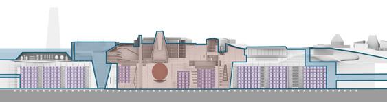
In order to solve their survival dilemma, this plan draws on the form of land art, integrates landscape architecture, and designs an artificial island with virtual currency mining as the main industry. Above the island, there are camouflage formed by mangroves and agricultural landscapes to demonstrate the height of the building and thus conceal the location of the underground machine room for the purpose of secrecy.

ISLAND FOR STATELESS
AN PROJECT OF INDUSTRY-ORIENTED LAND ART
Finished time: 2022.4
Individual work
Project type: Academic
Instructor:Sichuan Chen
Location: Cambodia

Combodia
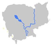

HISTORY OF CAMBODIA AND FORMATION OF FLOATING VILLAGES


The
COMPARISION OF LAWLESS LANDS
The Four Main Floating Villages In Cambodia
Floating Villages

Cambodia's
Chong Khneas


Other Places


 Rice growing area
Mung bean growing area
Mangrove Procypris rabaudi
Procypris rabaudi Hypophthalmichthys molitrix
Open water
Breeding pond
Cooling pool
Breeding pond
Scomberomorus niphonius
Supercomputer Room
Supercomputer Room
Entrance
Rice growing area
Mung bean growing area
Mangrove Procypris rabaudi
Procypris rabaudi Hypophthalmichthys molitrix
Open water
Breeding pond
Cooling pool
Breeding pond
Scomberomorus niphonius
Supercomputer Room
Supercomputer Room
Entrance

Rainy Season

There are buildings are build on the island ground and have different functions. At the same time, some of them are also hidden entrances connecting the underground world.
CONCEPT


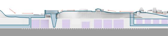
Navy camouflage pattern Navy warship zebra print
Camouflage is a clothing camouflage effect. Help the army hide itself from the enemy.
FUNCTIONAL ANALYSIS
Hight
Merchant vessel dazzle-painted as secnthrough a submarine periscopc.Cannot tell the front from the back. The same vessel on identical course painted grey.Can tell the front from the back.
Plan Section

Supercomputer room

Road

Plant

Rendering


POST-ANTHROPOCENCE


Stateless people return to their homeland after border problems and national conflicts are resolved, and after this, vegetation grows along the undulating islands, and after many years, the islands become pure landscapes on the map.


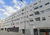
The project is located on a street corner in Les Corts, Barcelona. Barcelona has a unique urban look. This project is based on a previous study of Barcelona's urban development, a close observation of the buildings around the site, and a combination of the functional evolution of European balconies.
The project uses Folded Courtyard and Grilles to guide human vision and behavior.
Folded Courtyard:
In addition to being the internal courtyard and public space of the apartment, the tube is also the main vertical traffic of the entire apartment, which separates the street corner of the public on the first floor from other living Spaces. At the same time, by opening the hole, the cylinder integrates the internal visual relationship such as the size of the hole and the counterpoint relationship, linking the different two layers. The perforated aluminum sheet material reflects the sky and the surrounding environment, extending the space.
Grilles:
Different gradient effects are presented at different angles, while protecting the privacy of residents and preventing unnecessary eye contact, the use of color to make negative occlusions interesting
FLODED COURTYARD
BARCELONA CORNER APARTMENT
Finished time: 2023.9
Individial work
Project type: Academic
Instructor:Sichuan Chen
Location: Baecelona


b.


This type is for a single people, which is high efficient but not capable for more residentials in the future.


This type is for a single people or lovers, which is bigger than type I.


This type is for 2 people or lovers and has a separate living room, which is capable for more residentials in the future.


This type is for 2 people or lovers which is capable for more residentials in the future.


Floor II

Floor III

Floor IV

Floor V

Floor VI


Color Analysis
Trying 36 different typs of density and color patterns superimposition, with 3 layers.


Spacing Analysis
Trying 3 typs of different distence between 3 color patterns superimposition of grill
Rendering


No interval


Small interval


Big interval

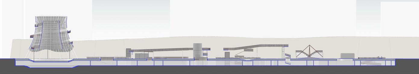
The project is a museum built for the ruins of the Ming City wall. The Ming wall of Beijing was destroyed during the war and urban expansion, and only a small section remains today. As the city grew and expanded, the wall was no longer a boundary separating the city, but was surrounded by residential and commercial areas. Today, the site itself is a recreational park for the surrounding residents.
Rebellion against traditional museums
Building a traditional museum around the site would crowd out the residents' activity space, and in this project, the best memorial to the wall is to revitalize the site and allow the wall to serve the lives of the surrounding residents in a new way.
Invisible museum
The project places the museum underground, connecting the above and below ground Spaces through courtyards and ramps. The underground space mainly undertakes the functions of exhibition, experience and cultural and creative shops, while the above space is used as a park for residents' activities, which is more entertaining. The red walkway in the site acts as the third traffic level to connect the site and stimulate the vitality of the site.

EAST BOULEVARD NO.9
INVISIBLE CITY WALL MUSEUM AND ACTIVITY CENTER
Finished time: 2022.6
Individial work
Project type: Academic
Instructor: Hanwen Liao、Zhang Meng
Location: Beijing


The museum is divided by several parts of yards, shops and activity spaces, which are linked by a sky path.

Shop
ObservationDeck
SkyPath
Linkallfunctionsaboveandundergrand. Besides,itisawaytoobservationdeck.
TheaterandObservationDeck
Aperfectplacetoappreciate thecitywall.
SmallTheater
Placeforresidents'square dance.
Restcourtyard
Aplaceforrestandprovidelightto theundergroundspace.
Skateboardyard
Aplaceforskatingand skateboardactivity.
Shops
Shop
Outdoortheater
Accesstheundergroundspacesand themainentrancetothemuseum.
Chilrencourtyard Entrance
Aplaceforchildrenandtheir parents.
MuseumcourtyardI
Treeyard
Aplacefortherest.
Thecourtyardinsidethe museum.
Museumcourtyardii
Thecourtyardinsidethe museum.
Elevator


PERSPECTIVE


RENDERING
The white installation above the westernmost theater will glow at night as a way to illuminate the site, and one can read the history of the wall displayed above by spiraling up a ramp. The luminous installation is also a monumental spiritual symbol, serving as proof that the walls of Beijing once guarded the city and its inhabitants.


TECHNICAL
DRAWING
Technical drawing shows the project's underground plan, ground floor plan and sectional view.

GROUND FLOOR PLAN
RENDERING
UNDERGROUND PLAN

SECTION
The project seeks to break down urban-rural boundaries and explore the possibility of fully integrating urban functions with rural landscapes. As a highly developed city, Tokyo is inevitably undergoing a process of gentrification, which not only brings about changes in the urban population structure, leading to equity issues, but also affects the cultural structure of the city, making the urban landscape homogeneous.
Carnival of anit-gentrification
The idea of merging the countryside with the city was the inspiration for formal rural urbanism. It is also an ideal answer for us to face the future urban and rural folding.
The struggle against gentrification is inspired by the parade in Japanese culture, where many rural symbols are inserted into empty buildings in the city like a parade queue, or replaced with urban space. In this state, the functions of both cities and villages have changed. The countryside is not only a producer, but also a favorable competitor of urban commerce. The cultural structure of the city has become more unique due to the addition of rural space.

COUNTRYSIDE INTRODUCTION PLANNING
ELIMINATE THE BORDER BETWEEN CITY AND COUNTRY
Finished time: 2022.10
Group work
Group member: Xudi, Jiaying Zhu, Linsheng Wu
Project type: 2022 UIA Competition
Instructor:Xiangyu Li
Location: Japan

Landscape Type
Production Type
Culture Type


Village 09: 美瑛町


Village 11: 開拓の村


Village 18: ほしのむら

Village 19: 伊根町 Village 12: 平野砺波

Village 13: 木曽町
14: 南木曽町
Village 15: 球磨村
Village 16:


om Toyo Ito's point of view we believe that reintroducing the countryside to the city would be a viable solution to the combination of urban and rural areas.


Rural areas are re-injected by capital, improving the possibility of regional economy.
The city’s infrastructure is updated.
Balancing urban and rural populations and enhancing mobility.

Urban Planning Srategy Design Srategy
Evaluation of Site Selection
With the above-mentioned advantages as the objective and Shibuya, Tokyo as the site, a systematic testing on city planning and architecture design is carried out under the plan.


Result A the population of capital .The idea of merging the countryside with the city was the inspiration for formal rural urbanism.
Result B : ng aging, the populg the countryside with the city was the inspiration for formal rural urbanism.
Result C opulation of capital .The idea of merging the countryside with the city was the inspiration for formal rural urbanism.
Strategy: From TOD to COD
Transit-oriented Development
Cultivate-oriented Development
Phase I: Streets_Between Urban and Architecture

Phase ll: Personalization Typology-based Spatial Reorganization


Different techniques are utilized to insert the rural characteristic space into the urban space, and the signboards and production spaces of different villages become part of the urban landscape.

Between the past and the future, is the space and time gap; Between work and life, is the gap of self; From one place to another, is the gap between thinking. So, let's start by thinking Here.
In-Between
In many countries, regulations set strict limits on the distance between buildings, and separate buildings cannot share the same wall. As the area of land that can be developed continues to decrease and the price continues to rise, the goal of maximizing the utilizable base area has become the pursuit of people. Therefore, after the subdivision of the plot, there is always a narrow gap between the buildings, that is, the urban gap space. In addition, abandoned buildings and infrastructure due to early planning errors and urban replacement will also create urban gap Spaces.
Wangfujing-dengshikou block, as the most representative old city in Beijing, its unique history and culture and the complexity of the block texture make this block full of energy The gap is full but in the gap, by adjusting the conflict in the gap, it will inject new vitality into the old block.

IN-BETWEEN
INVESTIATIN AND RECONSTRUTION OF BUILDING FACADES ALONG WANGFUJING STREET
Finished time: 2022.11
Group reseach, Individial work
Project type: Academic
Instructor:Yuefeng Fu
Location: Beijing
When D/H=1, the relationship between height and spacing is uniform
When D/H<1, oppressing sense When D/H>1, with a sense of detachment

Oppressing Comfortable Detachment

Street Aesthetics
According to Yoshinobuu Ashihara, Japanese streets in the 1970s were devoid of vitality and planning, and the construction of residential walls, billboards, neon signs, telephone poles and sound insulation walls all contributed to the chaos of the streets. In order to solve these problems, Yoshinobu Ashihara proposed many concrete measures, such as the retreat of the wall, the importance of shadow corner space, the setting of sunken courtyards, the setting of sculptures, the control of the rhythm of the street and the importance of the first outline of the street width.
Street scale corresponds to different strategies
Break the whole into pieces and make the big small
The core of the external space design lies in the "inverse space" between the huge and the small, that is, the "large space" in the huge city is restored to the "small space" with pleasant scale and human touch, and the visual feeling of people is fully considered. Inverse space is the transformation of internal and external space based on Gestalt psychology. Yoshinobuku Ashihara believes that the external space design with inverse space as the core means that architects or planners take the surrounding land of a single building as a building and an active space design.


Elevation Analysis I
The reconstruction project of Wangfujing Harbor City was started in 2007, and it was suspended intermittently for the following ten years. After a new plan was proposed in 19 years, it was suspended again due to the epidemic in 20 years. Therefore, we assume the shape of Wangfujing Harbor City after reconstruction, and unify the facade design with that around the church.
Structural Unit


Rendering

Elevation Analysis II
The glass brick is combined with the stone brick commonly used in traditional Hu buildings, and the two buildings are over each other by means of parametric random selection of points, so as to realize the function of the second floor meeting the office needs and the first floor serving the bottom business. Meanwhile, the semi-transparent wall is used to blur the boundary between the store and the street, and green plants are decorated near the load-bearing structure to make pedestrians feel relaxed when passing.
Wall Detail


Red Brick Glass Brick
East Elevation Rendering


Elevation Analysis III
The original facade of the International Art Garden Hotel is mainly window, and there is only one population in the west. After updating the original facade with timber, the facade is added to the decorative aspect, which echoes the other arch elements through the forward sloping canopy, which deepens the connection between the standing space and the walkway, providing shelter from the rain while allowing pedestrians to walk within the realm of the building.
Structural Unit

3D PRINTING MODEL

Rendering


Waste Colonialism:
At present, developed countries have been exporting their waste to developing or underdeveloped countries overseas in order to achieve good recycling figures, but they have exposed major flaws in their waste management systems, which cause millions of people to die every year from diseases caused by living near plastic pollution sources.
By making a work of art from domestic waste, I explore new ideas on waste disposal and trigger thoughts on this important social topic.

ANTI-WASTECOLONIALISM
Finished Time: 2023.11
Individial work
Project type: Academic Instructor:Ann Long


Finished time: 2023.08
Group work: Fan Hua, Xiao Yao, Jiaying Zhu, Yuxin Xu, Hanting Lian, Shiyi Wang Instructor:Hanwen Liao, Feiteng zhao, Peizheng Huang, Minshan Hu


