
15 minute read
THE JOURNEY


The “Open Road.” The very words invoke powerful imagery — freedom, adventure, horizon-pushing travel. The highways and byways to Yosemite Mariposa County accentuate these themes with every fresh fruit stand, riparian picnic area, roadside attraction, scenic vista and curving country road along the way.
When driving to Yosemite Mariposa County, there is is an atlas of options. This is a road trip that can take many paths (some extra-epic). Taking the fast ways on all-season highways is the conventional option that many travelers select. These “direct” routes can trim minutes off your travel time. Just minutes! But it’s the classic express — no stopping unless necessary and unilaterally approved by the person in the driver’s seat. Pack your snacks and beverages, and pray that there’s time for a perfectly-placed convenient restroom stop along the way. Here’s the trade-off. Freeways are not generally built through the prettiest parts of towns, cities and states. They are all about speed and straight lines. On the other hand, there are the scenic routes where vistas and points of interest along the way can actually amplify overall journey happiness. The steelbelted hum of your tires rolling at a calmer RPM is the perfect background music to conversation and wonder. Spontaneous stops: encouraged and rewarded.
The most memorable journeys often follow the road less traveled. By now, perhaps you see the path we advocate. Get that vacation vibe rolling from the moment you leave home! Get creative with your map app. Yosemite Mariposa County is laced with inspiring, spur-of-the-moment detours. Leave the interstate behind; take the interesting backroad to that quirky roadside attraction or crazy bend in the road. Explore, discover, and marvel at what’s passing by. Sure, you might get lost (in a good way). And, chances are you’re still going to arrive in Yosemite Mariposa County in time to catch a beautiful sunset and settle in for a happier hour.
Traveling from the San Francisco Bay Area
Driving from the San Francisco Bay Area, the GPS mapping gods will present several mainstream travel routes leading you across the state. They’re similar in time and distance and generally unremarkable in every way (until those jagged Sierra Nevada peaks pop into view).
In the spirit of the “journey,” we suggest that you resist these routes! There’s so much to see and explore once you drive away from the Bay and crest the Altamont Pass. Follow I-580 to Highway 132 east. Your reward: a scenic ribbon of two-lane highway and the Great Central Valley, which John Muir called “…the floweriest piece of world ever walked” (and he walked a good deal more than most!). Keep an eye out for signs to the San Joaquin River National Wildlife Refuge, a great place to get out and stretch your legs, walk your leashed pet, maybe even spread out a picnic blanket.
HIGHLY RECOMMENDED: take an intentional wrong turn anywhere along 132 and drive a few miles north or south. Say “woops!,” reset your map and see what amazing gems and vistas you will find when you’re off- track, but far from lost. More like found!
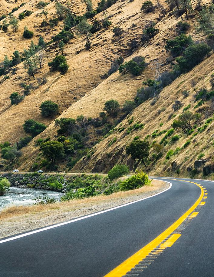
Everywhere along Highway 132 are country roads lined with fresh produce stands, fruit and nut tree orchards, dairy farms, ranches, friendly folks and happy farm animals. For a proper lunch check out the Twin Rivers Saloon, famous for its homemade fare just west of Modesto.
Highway 132 keeps rolling right through Modesto, setting for the Lucas-Coppola film classic, American Graffiti. Cross Highway 99 and stay on 132 east, which becomes the historic John Muir Highway east of Modesto. This route takes you through Snelling, an old mining town with gas, markets, and post office. Park, stretch your legs, and check out the tiny Snelling Courthouse building, California Historic Landmark #409, built in 1857.
Back on the road, you’re on the way to Lake McSwain /Lake McClure and the historic town of Coulterville
From Coulterville, options sparkle like gold: travel south along historic Highway 49 to Mariposa, or northeast to connect with Highway 120 on the way to the Big Oak Flat entrance to Yosemite National Park.
Another way to Yosemite Mariposa County out of Modesto: take Highway 99 south to Merced, exiting at Highway 140 bound for Mariposa. From Mariposa, 140 may be Yosemite’s best final approach, the allseason highway that rolls along at lower elevation to provide a straight shot into Yosemite Valley. Along the way, the fantastically steep walls of the Merced River Canyon elevate the wow-factor. Plenty of quality lodging options abound in Midpines, Briceburg and El Portal.
Between El Portal and Yosemite’s Arch Rock entrance, keep an eye out for the first Yosemite National Park signs where you can carefully pull over and snap IGworthy pics. See if you can spot one of several granite formations that cantilever over 140 and, to many passers-by, resemble the face of a bear.

Traveling from Southern California
California’s most populous region, Southern California is famous for busy freeways driven at either breakneck or bumper-to-bumper pace, depending on time and day (or, not). There are many ways to escape from L.A. for Yosemite-bound travelers. The 280 miles that separate Los Angeles and Yosemite Mariposa County are star-studded with historic outposts, cuisine, music, and a still-booming farming and ranching scene. Taking Interstate 5 out of the L.A. basin to the “Grapevine” is the most direct route for “point A to point B” if getting out of L.A. is the overarching priority. As I-5 drops down from the Grapevine into the mighty Central Valley, it’s decision time. How far north to travel before feeling the High Sierra’s eastward pull?
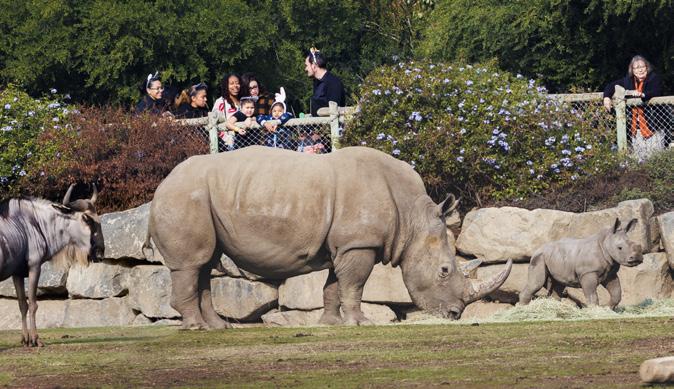
The most direct path is merging with Highway 99 where it splits from I-5, and taking 99 to Fresno. While generally nondescript as most direct routes tend to be, there are still several interesting offramp detours to explore along 99: Bravo Farms near Tulare (local handcrafted cheese and burntends brisket burritos); Buck Owens’ Crystal Palace (country music mecca) and Forestiere Underground Gardens (subterranean world handforged by a visionary Sicilian) in Fresno; and the Fresno Chaffee Zoo (Zoorassic Park!).
A more interesting option: continue on I-5 north until reaching the high-octane truck stop that is Kettleman City. After your lunch break at In-N-Out Burger (there are many other choices in K-City, too), continue on Highway 41 north for a classic Central Valley country drive on the way to Fresno. You want roadside attractions, we got you! Giant Transformer Robot , anyone? And, the Santa Rosa Nursery is the perfect place to pull over and smell the roses. As you roll into Fresno, Yosemite’s southern entrance is only about an hour away from Fresno by staying on Highway 41.
Bypassing the Grapevine altogether is an even wiser option for road trip wonder. From Los Angeles’ northeastern flank, routes through the Angeles National Forest and Highway 15 will bring travelers to either Central Valley or Eastern Sierra paths to Yosemite Mariposa County. In the summer, take the opportunity to take Highway 195 north through the austere Eastern Sierra high desert to Mono Lake and then west over Tioga Pass. Of all the scenic byways in Yosemite, Tioga Road rises above them all (literally, as well). The 46-mile drive from Lee Vining to Crane Flat gains 4,000 feet in elevation as it cruises through a glaciated granite wonderland of immense vistas such as Olmsted Point , roadside domes and peaks, the glittering sapphire jewel of Tenaya Lake and picturesque Tuolumne Meadows. Before making your Tioga ascent, pull over at the Mobil to fuel up at the Whoa Nellie Deli. (Try the fish tacos. You won’t regret it.)
And for something completely rock-n-roll, dial in some Beach Boys or Eagles and cruise up 101/Pacific Coast Highway out of L.A. In Ventura, veer over to Highway 33, the Maricopa Highway, north through the heart of the Central Valley up to Highway 99. Or continue on 101 through Santa Barbara to San Luis Obispo and Paso Robles, before bearing east at Atascadero on Hwy 46 to Hwy 41, continuing on to Fresno.
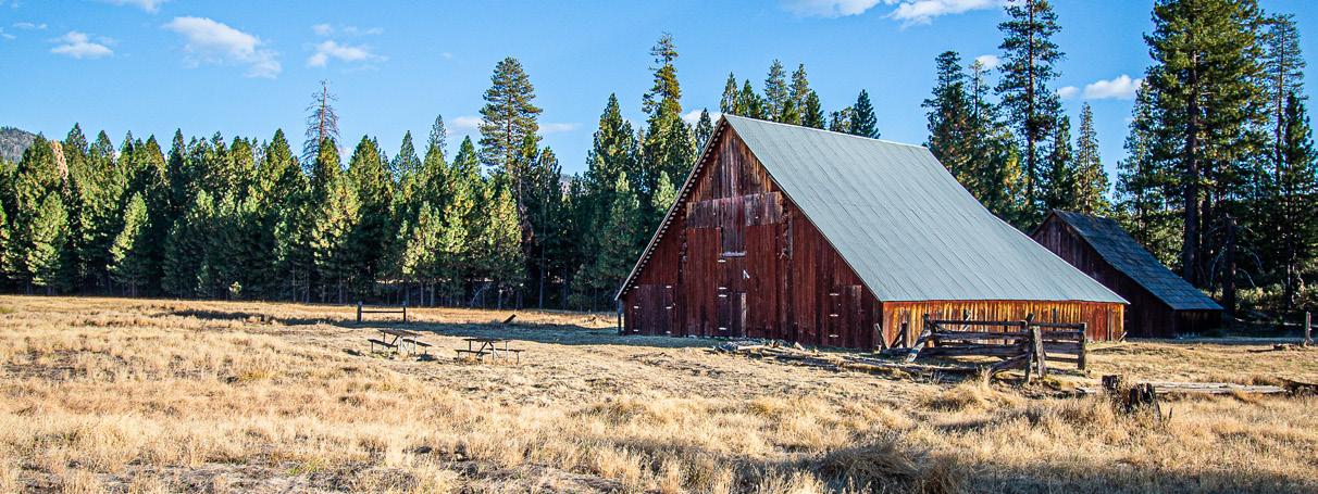
Fresno offers the opportunity to call a true audible. Put the town of “Raymond” or “Catheys Valley” in your GPS and redirect to these tiny historic Yosemite stage stops and cattle towns. From there, no matter your final destination, you’ll be in for a treat of narrow country lanes, rolling oak studded Sierra foothills, and Norman Rockwell-approved ranch and barn backgrounds to savor on your way to Yosemite Mariposa County.
Yosemite Mariposa County Highways & Hubs
Here’s a highway-by-byway profile of Yosemite Mariposa County’s principal California State Routes (SR) and the towns and hubs along the way. Settle into those bucket seats and buckle up for the discoveries ahead.
HIGHWAYS WEST / EAST
California State Route 140 –
The All-Weather Highway
Highway 140, the “All-Weather Highway” is the surest route to Yosemite National Park and Yosemite Valley from Merced. Relatively level and lower-elevation, it delivers you directly into the mouth of Yosemite Valley (4,000 feet). Out of Merced, Central Valley farms give way to rolling Sierra foothills around Catheys Valley, some of the richest grazing ranch land in the West. Roll down your windows, take in the surrounding foothills, and with a little luck spot a flock of sheep, herd of longhorn or team of horses off the road.
At the Catheys Valley junction, take Hornitos Road to historic Hornitos, in the day a bawdy Gold Rush town sprinkled with gold dust. Back in its mining heyday, this was one of the wildest spots in California, with gaming tables, fandango halls, and shooting scrapes in abundance. Joaquin Murrieta, the infamous Gold Rush-era outlaw who gained Robin Hood-like notoriety, is said to have frequented saloons like the still-standing Plaza Bar and made many an escape through a secret passageway under the Campodonica store. The Hornitos Masonic Hall, Ghirardelli & Co. store ruins and St. Catherine Catholic Church make this town an essential detour off 140.

Another, shorter detour off 140 just three miles west of Mariposa is Agua Fria, the original county seat and bustling gold mining town. Named for the cold underwater springs it was built upon, Agua Fria is mostly a memory now save for some fascinating historical plaques.
The history-rich town (and county seat) of Mariposa sits astride the crossroads of SR 140 and SR 49, built on bedrock Golden State history. Many of Mariposa’s splendid streets and structures are among the oldest in California. Several disastrous fires early in the settlement’s history convinced settlers to rebuild with stone, brick and adobe. Many of those structures still exist today and have been in more or less continuous use without need for major restoration. Mariposa also boasts a number of excellent wineries, restaurants and shops. The town is dotted with great indie markets and cafés, curio shops, and character. There are plenty of lodging options in every budget category to stay the night.
Continuing northeast out of Mariposa, Highway 140 climbs to the Midpines summit (elev. 2,966 ft.) before dropping down toward the picturesque suspension bridge at Briceburg and the Wild & Scenic Merced River Canyon to El Portal.
Midpines and Briceburg keep the small-town vibe humming along 140 by offering numerous turnouts and picnicking opportunities along the Wild & Scenic Merced River Canyon. Day-use picnic areas such as Red Bud, Cranberry Flat, Indian Flat, and McClendon Beach are great highway respites.
El Portal is literally “the portal” to Yosemite, the last small town before the Arch Rock entrance. El Portal also served as the terminus for the historic Yosemite Valley Railroad. One of the highlights of the town is its display of equipment and buildings from these railroading days.
California State Route 132 -
The John Muir Highway
For travelers arriving from the north and west, Highway 132 provides a scenic, “take it easy” route to Yosemite’s north entrance. From Modesto, 132 travels through Northwest Mariposa County’s “lakes district,” skirting Lake Don Pedro and Lake McClure. Lake McClure / Lake McSwain are fed by the mighty Merced River with protected swim areas, day-use picnic tables and roadside aquatic recreation including the floating obstacle course called the Splash-n-Dash Aqua Park. Who says a mid-trip swim is out of bounds?
132 meets Highway 49 at Coulterville, an historic town with a bohemian vibe. Get out, stretch your legs and take the downtown walking tour to see why Coulterville has been named a California State Historic Site. In fact, Coulterville features more than 40 historical buildings.
Coulterville is a good place to be hungry. The Coulter Café & General Store has a metro foodie menu and gorgeous flagstone, dog-friendly patio. Before continuing the journey, discover another road trip food find — the Cakewalk Cake Shop & Bakery, an heirloom haven for breakfast, lunch and gourmet coffee.
Continuing northeast from Coulterville, Highway 132 officially becomes the John Muir Historic Route (J132) in honor of the sage of the Sierra, who took the same route into Yosemite over 100 years ago (on foot, of course). Talk about a journey! After Coulterville, J132 climbs toward Greeley Hill, with impressive Central Valley and High Sierra vistas. It joins Highway 120 just west of Buck Meadows.
California State Route 120 – The High Road
Not for the faint of heart, Highway 120 to Yosemite National Park climbs in serpentine aspect from Groveland through Buck Meadows, past Foresta and on to Yosemite Valley. This road was regarded as a marvel of engineering when completed in the 1930s, as it was carved into the sheer cliffs and through tunnels of hard Sierra granite. When taking this route, you will be rewarded with stunning first glimpses of Yosemite Valley on the way to Yosemite National Park’s Big Oak Flat entrance.
Buck Meadows marks the northern edge of Yosemite Mariposa County along SR 120. Here you will discover numerous vacation rentals, Blackberry Inn Bed and Breakfast and the Buck Meadows Restaurant and Lodge, a great place to fuel up before or after Yosemite.
Tucked into Yosemite’s peaceful northwest corner, Hetch Hetchy Valley is one of the Park’s less-visited treasures. Soaring peaks, steep canyons, and thundering waterfalls are here. O’Shaughnessy Dam, at the west end of the valley, provides a nice overlook of the reservoir and wilderness beyond, including 1,000-foot-plus Wapama Fall.
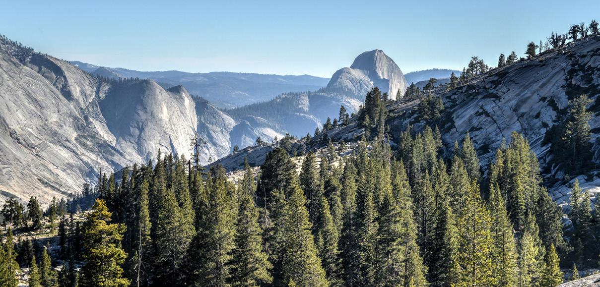
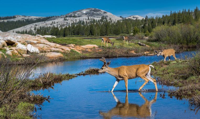
As Highway 120 rises into Northern Yosemite, it becomes Tioga Road, the main artery connecting the Sierra Nevada’s western and eastern flanks. The 46mile (62 km) drive from Crane Flat to Tioga Pass tops out at nearly 10,000-ft. elevation at Tioga Pass as it cruises through a glacial and granite wonderland of immense vistas such as Olmsted Point, the glittering sapphire jewel of Tenaya Lake and idyllic Tuolumne Meadows. Travelers from Southern California can opt for Yosemite’s east gateway by taking Highway 395 north to SR 120 east at Lee Vining.
Crane Flat is at the crossroads of Big Oak Flat Road and Highway 120, the last best place to fuel up before heading toward Yosemite high country or the Hetch Hetchy Valley. The Tuolumne Grove of Giant Sequoias rises just off Highway 120, a half mile from Crane Flat. This is a smaller grove of Giant Sequoias is considered moderately accessible, with a hike of 2.5 miles each-way. Nearby Merced Grove is another chance to see some majestic superflora. Approaching Yosemite from the east, Highway 395 is a grand tour of the Cali high desert as it rolls northward to Highway 120. Mono Lake, the June Lake Loop and the Town of Mammoth Lakes are notable points of interest along 395. The whistle-stop of Lee Vining marks the turn to Highway 120/Tioga Pass. Before your ascent, stop in for fuel at Lee Vining’s Whoa Nellie Deli, an oasis-like restaurant and gas station at the base of Highway 120.

Tioga Road opens in late May or June, depending on the winter snowpack and road repairs. It typically closes in late October or November, depending on winter storm conditions.

HIGHWAYS NORTH / SOUTH
California State Route 49 –Golden Chain Highway
Highway 49 is California’s golden brick road, a 277mile stretch of small towns that encompasses all the hope, heartbreak and dreams of the California Gold Rush. It’s even named after the 49ers, the wave of immigrants, entrepreneurs and misfits who swept into California seeking fame and fortune. Charming mining towns dot the “Golden Chain Highway,” graced by the panoramic vistas and burbling streams of the western Sierra Nevada foothills.
The highway carves a path through Gold Country like a vein of precious historic ore. When driving it, we recommend keeping to the original route. When a modern bypass option is offered, stay the course and resist the fast lanes! The nearly century-old highway has been modernized and straightened out in sections for the sake of saving drive time — often “by-passing” old 49’s charm and history. Much like fabled Route 66, the original Highway 49 traveled through each small historic town and village along its way.
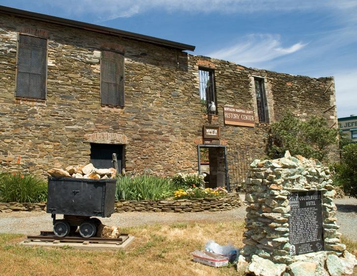
Highway 49 crosses all major western highways leading to Yosemite Mariposa County. If you’re heading south on 49 from Sonora or Angels Camp, Coulterville is the first town you enter in Mariposa County. John Muir traveled through this tiny mining town on his first walking journey from San Francisco to Yosemite. The town seems marvelously frozen in time. Slip into the Northern Mariposa County History Center for a great look into the region’s rich gold-dusted history.
We’ve been encouraging side trips, here’s another. The Bear Valley Road (county road J16) spurs off to connect Bear Valley with Hornitos. At the crossroads of Highway 49 and J16, Bear Valley is the original site of Colonel John C. Fremont’s empire.
Fremont arrived here after the conclusion of the Bear Flag Revolt , bought a 44,000-acre parcel of the Mexican land grant, Rancho Las Mariposas, and renamed it Bear Valley. Look for the Bear Valley Historical Marker on 49 and the original buildings from the mining days including the BonTon Saloon, Trabucco Store and Odd Fellows Hall.
The drive from Coulterville to Mariposa on highway 49 is curvy and narrow with numerous steep grades. We do not recommend this route to large vehicles or RVs. That said, it is an incredibly scenic route and is a top drive for folks on motorcycles or driving sporty cars.
Roughly mid-way between Mariposa and Coulterville is the Bagby Campground & Recreation Area hub for hiking and biking. The Fish Camp Store is well-stocked pre-Park supply stop.

Located where the Wild & Scenic Merced River widens and flows into Lake McClure, this is a great place to swim, kayak, camp or fish. Bagby Campground has great water views of the steep Merced River canyon and gorge beyond. In the fall when the lake water level gets low the foundations of the old mining town of Bagby become exposed at the entrance of the campground on the north side of the river.
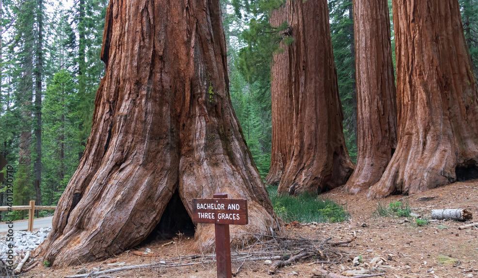
And there you are, at the South Gate to Yosemite National Park. This is Mariposa County’s Southern Yosemite region, rich in history and dotted with attractions. After entering the Park, 41 is also known as Wawona Road. The Mariposa Grove of Giant Sequoias is the perfect stop just inside the Park gate. Sequoiadendron giganteum, the Giant Sequoia is among the largest and oldest living things on earth. Mariposa Grove is home to about 500 of these mature titans!
California State Route 41
– Sea
to Sierra Crossing California from Morro Bay on the Pacific Coast to High Sierra Yosemite, Highway 41 is the popular southern approach to Yosemite National Park. For many this route will begin in Fresno and heads northeast through rolling foothills. Extra credit for spirited SoCal road trippers picking up 41 way out west at Highway 1 before journeying east to Fresno.
With Fresno in the rear-view mirror, 41 takes a serpentine bent as it cruises toward Oakhurst. Soon nature’s air conditioner kicks in as you gain elevation and the scent of sugar pine mingles with fir and incense cedar. Roll down those windows as you head toward Mariposa County’s southern border on Highway 41!
Leg stretching opportunities expand as you approach Mariposa County, including the Nelder Grove of Giant Sequoias just a few miles off 41. The Yosemite Sugar Pine Railroad is another rewarding place to turn off the engine and turn on discovery mode!

Up ahead is the historic mill town of Fish Camp, just two miles from the Yosemite National Park boundary. Home to charming bed-and-breakfast inns, cabin rentals, and the magnificent Four-Diamond Tenaya Lodge at Yosemite, Fish Camp is surrounded by stands of conifers and a network of unpaved Sierra National Forest fire roads. It’s an outdoor lover’s
Continue north through the Park to historic Wawona and the Victorian-era Wawona Hotel, the Yosemite History Center, and the Wawona Golf Course. Those who take time to linger in Wawona are always rewarded. Walk the Wawona Meadow Loop trail and amble over Wawona’s historic covered bridge, one of the very few in California. The South Fork of the Merced River at Wawona is a lovely place to camp, meditate, or swim. Vacation rentals are abundant here, many in close proximity to Chilnualna Falls.
Highway 41 continues on to Yosemite Valley, passing by Yosemite West, where a number of privatelyowned mountain homes and condos are offered as vacation rentals. At Chinquapin, Glacier Point Road leads to Badger Pass Ski Area in winter, to Glacier Point in summer, and to remarkable Valley rim overlooks year-round.
Highway 41’s closing act is one of the world’s most photographed vista points: Tunnel View and its renowned panorama of Yosemite Valley, bejeweled by scenic titans including Bridalveil Falls, Half Dome and El Capitan. Continue into Yosemite’s fabled valley. You have arrived.
Yosemite Sugar Pine Railroad
Mariposa Grove of Giant Sequoias
Chilnualna Falls


