WANDIN NORTH TOWN CENTRE

MASTERPLAN


//
JULY 2023
ACKNOWLEDGEMENT OF COUNTRY
We respectfully acknowledge the Traditional Owners, the Wurundjeri People as the custodians of this land. We also pay respect to all Aboriginal community elders, past and present, who have resided in the area and have been an integral part of the history of this region.

Wandin North Town Centre Masterplan 1
CONTENTS
1. INTRODUCTION Vision & Purpose 4 Masterplan Area ........................................................... 5 2. CONTEXT Topography & Landscape Characters ........................... 8 Traffic/Pedestrian Movement ........................................ 9 3. PRECINCT ANALYSIS Precinct Plan 12 Precinct Analysis – Town Centre Precinct ..................... 13 Precinct Analysis – The Field Precinct .......................... 14 Precinct Analysis – Link Precinct .................................. 15 4. MASTERPLAN Town Centre Masterplan 18 Town Centre Sections 19 Field Masterplan 20 Field Sections ............................................................. 21 Link Masterplan .......................................................... 22 Proposed Street Tree Species .................................... 23 Costings 24 1. INTRODUCTION Figure 1 ........................................................................ 5 Figure 2 ........................................................................ 5 Figure 3 ........................................................................ 5 Figure 4 ........................................................................ 5 Figure 5 5 Figure 6 5 Figure 7 ........................................................................ 6 Figure 8 ........................................................................ 6 Figure 9 ...................................................................... 10 Figure 10 .................................................................... 11 2. PRECINCT ANALYSIS Figure 11 14 Figure 12 .................................................................... 15 Figure 13 .................................................................... 16 Figure 14 .................................................................... 17 3. MASTERPLAN Figure 15 21 Figure 16 23 Figure 17 23 Figure 18 .................................................................... 23 Figure 19 .................................................................... 23 Figure 20 .................................................................... 24 Figure 21 25 Figure 22 25 Figure 23 26
TABLE OF
TABLE OF FIGURES

INTRODUCTION
Wandin North is a picturesque township sitting at the gateway to the Upper Yarra Valley and home to a diverse and vibrant community.
Wandin North Town Centre Masterplan Wandin North Town Centre Masterplan 3
VISION:
Wandin North is the cherished local centre for a vibrant and highly connected community who meet in the cafes and al fresco dining areas or gather on the lawns and open spaces to unwind and for events. Renowned for its welcoming avenues of colourful and shady trees and its celebration of its agricultural heritage, tourists and trail users are drawn to its unique charm to sample a taste of local produce in a relaxed community atmosphere. Beautiful in the day and bustling at night, this is the place that locals call ‘home’.
PURPOSE:
The purpose of this Masterplan is to provide clear guidance regarding the design and delivery of public realm improvements in the Wandin North town centre. The directions and illustrations contained in this document provide guidance on the desired public realm outcomes that are to be achieved in the Masterplan Area.


STRUCTURE:
The structure of the Masterplan is set out to provide the details of the natural and built environments context in which Wandin North is located. It orders the Masterplan Area [Figure 8] into three precincts to analyse the current public realm and provide masterplans that outline public realm improvements. The context section describes the key characteristics of the town centre’s natural and built environments that influence the design directions of the Masterplan. The precinct masterplan section provides a framework of design initiatives to guide the revitalisation of the public realm of the Wandin North Town Centre.

BACKGROUND:
The Wandin North Town Centre Masterplan was developed in conjunction with extensive community and trader engagement. Council undertook this engagement to identify issues or opportunities for the town centre leading to the development of a draft Wandin North Town Centre Masterplan. This draft document was taken back to the community for further review. Based on this final feedback, the document has been updated and issued as the Wandin North Town Centre Masterplan.

Wandin North Town Centre Masterplan 4
Figure 4: Existing car parking, P.J. Mould Reserve
Figure 5: Viewing to Greenglades Park
Figure 3: P.J. Mould Reserve
Figure 6: Existing field
Figure 1: Existing footpath, Warburton Hwy interface
Figure 2: Existing footpath, P.J. Mould Reserve interface
MASTERPLAN AREA:

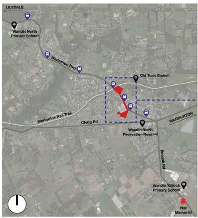
Wandin North is located approximately 7km east of Lilydale and approximately 27km west of Warburton. It is the first township you reach when you turn on to the Warburton Highway that links the townships of the Upper Yarra Valley.
The subject area of the Masterplan encompassed the shopping precinct, PJ Mould Reserve, the Greenglades Court Reserve, the open space area adjoining the Warburton Rail Trail and the section of the Warburton Highway corridor that links these areas. The boundary of the area is outlined in Figure 8.

Wandin North Town Centre Masterplan 5
Figure 7: Locality map
Figure 8: Scope area
CONTEXT
key characteristics of Wandin North’s natural and built environments
Wandin North Town Centre Masterplan Wandin North Town Centre Masterplan 7
TOPOGRAPHY & LANDSCAPE CHARACTER:
The topographical characteristics of the Wandin North Town Centre are established by its positioning on the upper slope of a prominent ridgeline that falls away from the south to the north. A section of Warburton Highway between Union Road and George Street, where the majority of local businesses are located, is on a relatively mild incline compared to further north. The shop fronts of this area are highly visible from vehicles approaching from Seville (north bound) and frame views when coming from Lilydale (south bound). A section of Warburton Highway beyond George Street towards the north falls steeply with an approximate 15m level difference along the vacant parcel of land located between the town centre and the rail trail. The top of the open field provides an excellent vantage point, with views to the north of the Yarra Valley. Union Road falls towards Warburton Highway with an approximate 10m level difference between the intersections of Clegg Road and Warburton Highway.

Landscape characters of this area fall into the Council’s Ecological Vegetation Class (EVC) No.45, consisting of mostly Messmate Forest and shrubland. There is no sense of arrival with no street trees along Warburton Highway between Warburton Rail Trail and Union Road with the exception of a small stand of large gum trees (Eucalyptus/Corymbia spp.) at the corners of Rue De Gare, Union Road, and Prospect Road. Red Flowering Gums (Corymbia ficifolia) of Avenue of honour are on the south verge of Warburton Highway between Union Road and the roundabout on the east. PJ Mould and Greenglades Reserves have significant large trees including gum trees (Eucalyptus/Corymbia spp.) and fig trees. Blue Berry Ashes (Elaeocarpus reticulatus) are planted along the footpath on the western side of car park surrounding PJ Mould Reserve. There is a large deciduous tree, European Hornbean (Carpinus betulus) surrounded by deck located at the entrance to a pedestrian link from the retail precinct to a pocket park adjoining Greenglades Court. PJ Mould is the main locally usable public open space, and the main ceremonial activity for the community is held at the cenotaph which is isolated and located well outside the town centre.
LEGEND
Key views
Significant trees on public lands
Wandin North Town Centre Masterplan 8
TRAFFIC & PEDESTRIAN MOVEMENT:
Wandin North’s main access routes are via the Warburton Highway to the north and east and Clegg Road to the west. The intersection of these thoroughfares is characterised by a large roundabout to the southeast of the township.

There are currently no formal pedestrian crossings of Warburton Highway in the township, pedestrians instead informally cross at the Warburton Rail Trail, Rue De Gare and Union Road. A concrete footpath is provided on the western side of Warburton Highway granting direct access to the retail precinct of Wandin North and the Warburton Rail Trail. Formal footpaths also circulate pedestrians through the PJ Mould reserve and out to the Greenglades Court Reserve. Informal pedestrian links characterises much of eastern side of Warburton Highway aside from a concrete footpath granting access to properties along Rue Du Gare. The Warburton Rail Trail is the primary pedestrian and tourist route to Wandin North, running to the north of the township. The speed limit of Warburton Highway in the town centre is currently 60km/h with 60-degree angle parking along Warburton Highway and 90-degree angle parking around PJ Mould Reserve. There are 3 bus stops within the township located at the intersection of Warburton Highway and Union Road, George Street, and Warburton Rail Trail.
LEGEND
Extent of works
Streetscape area
Car parking
Formal pedestrian footpath
Informal pedestrian links
Warburton Rail Trail
Bus route 683 (South bound)
Bus route 683 (North bound)
Existing bus stop
Pedestrian zebra crossing
Unmarked crossing areas on George St & Union Rd.
Unmarked crossing areas on Warburton Highway
Wandin North Town Centre Masterplan 9 SCALE @ A3 H 1:1000 GEORGESTREET UNION ROAD LILYDALE
WARBURTON RAIL TRAIL WARBURTONHWY
Lorem ipsum
Figure 10 - Locations of traffic and pedestrian movement
PRECINCT ANALYSIS
The Wandin North Town Centre Masterplan is divided into 3 precincts
Wandin North Town Centre Masterplan Wandin North Town Centre Masterplan - Draft for Consultation 11
PRECINCT PLAN:
The Wandin North Town Centre Masterplan is divided into 3 precincts: the Town Centre, Link and the Field Precincts. Each precinct contains its own unique characteristics and potential for intervention, that has been identified through the initial consultation period.

Town Centre Precinct:
With shops, cafes, and other retail this is the commercial and social heart of the township. The issues identified in this area are the width of the footpath adjacent the highway, on-street carparking adjoining the highway, traffic speeds, the lack of a pedestrian crossing across the highway within the town centre, a lack of landscaping and street trees interfacing with the highway, few street furniture choices for pedestrians and a lack of space for outdoor dining.
Link Precinct:
This precinct provides a connection between the towns centre and the Warburton Rail Trail and the adjoining Field precinct. The precincts’ current primary function is as an access point for the Warburton Rail Trail via a concrete path on the western edge of Warburton Highway. Some of the issues identified are the lack of pedestrian crossing and traffic speed along Warburton Highway, limited accessibility and signage to and from the Warburton Rail Trail, the incomplete footpath network on the eastern edge of Warburton Highway and the lack of street trees identifying the entrance to the town centre.
Field Precinct:
This precinct provides a large open space area as well as access between the town centre and Warburton Rail Trail. Some of the issues identified are the lack of a pedestrian crossing for the Warburton rail trail across Warburton highway and the speed of traffic through this intersection, little to no signage to the Wandin North township and no footpath on the eastern side of Warburton Highway, drainage swales disconnecting the open space from the Warburton Rail Trail and limited access to the field.
Wandin North Town Centre Masterplan 12 SCALE @ A3 H 1:1000 WARBURTON Greenglades Court Playground P.J. Mould Reserve UNION ROAD LILYDALE WARBURTON RAIL TRAIL Wandin NorthWarburton Rail Trail Start Wandin North Old Train Station WARBURTON HWY RUE DE GARE GEORGESTREET 1 2 3 LEGEND Town Centre Precinct Link Precinct Field Precinct 1 2 3
Figure 11- Precinct Plan
TOWN CENTRE PRECINCT:
For the Town Centre precinct the issues noted from the community consultation identified 3 main themes: car parking on Warburton Highway, traffic issues including the lack of pedestrian crossing and the speed limit of Warburton Highway and landscaping/streetscape. These key issues and our analysis of the Town Centre precinct are summarised below and shown on Figure 12.
Car park on Warburton Highway:
Car parking along the shop fronts adjoining Warburton Highway is problematic for users. Drivers pulling into parking bays and reversing out to join the highway find the experience uncomfortable. The traffic speed of Warburton Highway at 60km/h has been noted as being an issue when accessing or leaving car parking spaces.
Pedestrian crossing:
There is currently no pedestrian crossing provided across the Warburton Highway within the Wandin North town centre, pedestrians instead informally crossing at George Street. Warburton Highway therefore severely limits pedestrian access between the east and west sides of town centre.

Landscape/Streetscape:
It has been raised that there are currently no street trees in the retail frontage on Warburton Highway. There is also no shade at the corner of Union Road and George Street, and no footpath on the eastern side of Warburton Highway limiting pedestrian access to Wandin North for locals. Comments have been made about the steep cross fall of pavement and that the streetscape is lacking a consistent pavement style with 3 currently in use: coloured concrete, exposed aggregate and brick pavers. There is also a lack of comfortable and accessible street furniture, that the seats around the sculpture lack any shade and the general lack of outdoor activation along the highway due to the narrowness of the footpath. The lack of visual connection between the car park around PJ Mould and Greenglades Court has also been noted as an issue. Street trees around the shops are very poor form with low and split trunks that block sight lines and offer minimal shade.
There are currently no picnic tables in Greenglades Reserve, the toilet at PJ Mould Reserve needs refurbishment, and the area around the Ernst Fries sculpture could be improved so that it is better used.
LEGEND
Dangerous parking access
No pedestrian crossing
Traffic speed too high
Lack of landscaping
No footpath
Lack of shaded area
Narrow footpath
Lack of consistent pavement
Lack of comfortable furniture
Lack of outdoor activation
Lack of visual connection
Power lines overhead
13 N H 1:750
Playground
Greenglades Court
UNION
WARBURTON
P.J. Mould Reserve
ROAD WARBURTON HWY
LILYDALE
Figure 12 - Analysis Diagram - Town Centre Precinct
THE FIELD PRECINCT:
For the Field Precinct, key issues noted from the consultations identified 2 main themes; the lack of a pedestrian crossing of Warburton Highway for the Rail Trail and limited connections to the town centre. Key issues from the consultations and our analysis for Field precinct are summarised below and shown in Figure 13.
Pedestrian Crossing:
There is currently no pedestrian crossing at the intersection of the Warburton Highway and the Warburton Rail Trail. The highway is a significant barrier for users of the Rail Trail. The lack of a crossing results in both safety and convenience issues with pedestrians and trail user having to wait for gaps in the highway traffic to negotiate the crossing point. It was also noted the traffic speed along Warburton highway was too high for a town centre environment.
Limited pedestrian links between the town centre and Warburton Rail Trail:
There is currently no easily accessible footpath access or clear signage to the town centre from the Warburton Rail Trail to Wandin North Town Centre. There is no footpath provided on the eastern side of Warburton Highway severely limiting access. The drainage swale along Warburton Highway and Warburton Rail Trail impede access and creates significant barriers for people with reduced mobility. The eastern interface of the field is dominated by timber paling and chain mesh fencing; the site falls at an approximate 10% angle from the town centre end towards the Warburton Rail Trail. The site is under used due to a lack of amenities, paths and other landscaping that could make this space an attractive area for trail users to utilise as a rest area and as a gateway for the town centre. Existing amenities at Wandin North Warburton Rail Trail Start are car parking, shelter, picnic tables & seats, drinking fountain and signage.

LEGEND
Drainage swale
Fences
Gravel driveway
Pedestrian/cycle crossing
Traffic speed too high
Minimum visual and physical link for cyclists/ pedestrians between Warburton Rail Trail and the town centre
Slope/Fall
No connection between Warburton Rail Trail
No toilet nearby on Warburton Rail Trail
Ordinary entry signage
Post Office outside town centre
Power lines overhead
Wandin North Town Centre Masterplan 14
SCALE @ A3 H 1:750
LILYDALE
Figure 13 - Analysis Diagram - Field Precinct
WARBURTONHWY WARBURTON
RUE DE GARE
LINK PRECINCT:
The Link Precinct is the area of the Warburton Highway road reserve that connects the Town Centre Precinct to the Field Precinct. This precinct is to provide connecting corridor with significantly improved active transport routes and streetscape elements.

There is currently no pedestrian crossing along Warburton Highway and the traffic speed in this area is high for a town centre area. There is limited links for pedestrians between the town centre and Warburton Rail Trail with no easily accessible linkages or clear signage to the town centre. A partial footpath is provided on the eastern side of Warburton Highway, but the drainage swale and unsealed road shoulders minimises pedestrian accessibility; there is currently no slip lanes for turning vehicles into adjoining streets.
LEGEND
Drainage swale
Gravel driveway Partial footpath on the eastern side of Warburton Highway
Traffic speed too high
Minimum visual and physical link for cyclists/ pedestrians between Warburton Rail Trail and the town centre
No slip lane for turning vehicle
Power lines overhead
WARBURTON HWY WARBURTON LILYDALE
RUE DE GARE GEORGESTREET
Figure 14 - Analysis Diagram - Link Precinct
PRECINCT MASTERPLANS
Wandin North Town Centre Masterplan Wandin North Town Centre Masterplan - Draft for Consultation 17
provides a framework of design initiatives to guide the revitalisation of the public realm
TOWN CENTRE PRECINCT:
After reviewing the insights captured from the community consultations, we have developed a landscape masterplan for each precinct. Key items for Town Centre Precinct are listed below.

Western interface of Warburton Highway:
Advocate for a signalised pedestrian crossing to be installed either near the bus stop at George Street or at the intersection of Union Road. Advocating for reducing speed limit of Warburton Highway to 40~50km/h. Increasing the angle of highway parking to be 45-degree angle car parking would improve safety when reversing, and minimise width of car park zone whilst extending the width of footpath. The footpath which is currently 3.4m wide will be widened to 4.5m wide, offering a 1.1m extension and further promote outdoor dining opportunities on the footpath. Further flaring of the footpath would occur between Marigold Way and Union Road to approximately 8m wide. Tree planting in car park would occur between kerbs and wheel stops and a continuous pavement treatment would be installed over the crossover. Large Wandin North signage or lettering would be installed at the corner of Union Road and Warburton Highway.
Eastern interface of Warburton Highway:
Installation of a minimum 1.5m wide sealed (asphalt) road shoulder, a kerb and a minimum 1.5m wide concrete footpath. Street tree planting to occur between kerb and footpath.
Entry headland:
A shade structure or arbour with vines would be built adjacent to the Ernst Fries sculpture. New shade trees to be planted in the car park, and further outdoor dining areas to be built with feature pavement and a shade sail for enhancing visual link to Greensglades Court Reserve.
PJ Mould Reserve:
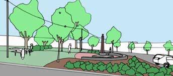
Improvement of the park including provision of informal seating area which also acts as a ceremonial gathering space for relocated cenotaph, re-plant shrubs and groundcovers where missing and top up crushed gravels for the pavement areas with new edging.
Greenglades Reserve:
Additional shade structure, picnic tables and seat to be installed in the play area.
LEGEND
Signalised pedestrian crossing options
Bus shelter
45° angle car parks with wheel stops and tree planting
4.5m wide footpath
Approx. 8m wide plaza with tables and seats
“Wandin North” signage wall
Shelter/arbour with vines
Relocation of Cenotaph
Shade trees among car parking with seating underneath
Added pavement area for outdoor dining
Upgraded pedestrian link with outdoor dining
Concrete path and street trees
Improvement to Greenglades Court Reserve
Wandin North Town Centre Masterplan 18
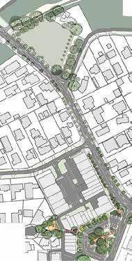
Figure 15 - Town Centre Precinct Masterplan
WARBURTON HIGHWAY UNION ROAD GEORGESTREET 7 3 2 3 4 5 9 9 10 11 12 17 8 14 6 1 13 15 16 15
Improvement of P.J. Mould Reserve Bike Parking Area Artwork and Community Notice Board on IGA wall Additional parallel car parks 1 2 3 4 5 6 7 8 9 10 11 12 13 14 15 16 17 1



Wandin North Town Centre Masterplan 19 Centre line of Highway Property boundary Property boundary Proposed kerb Remove existing kerb 4500 4800 3500 3700 3700 1500 1500 1500 Footpath Safety buffer Existing north bound lane to remain Existing south bound lane to remain Shoulder Nature strip Footpath 45 degree Angle car park
Section A
- Town
plan 3 1 2
Figure 19
centre
section
A Key
Figure 18 - 3. Laneway activation - Connection to playground.
Figure 17 - 2. Viewing to the north end of P.J. Mould Reserve.
A
Figure 16 - 1. Viewing to the sculpture at the corner of Union Road.
FIELD PRECINCT:
Key items for Field Precinct are listed below.
Installation of a signalised pedestrian crossing at the intersection of the Warburton Rail Trail and Warburton Highway.
Upgrading the bus stop and better access to the field. An Upgraded path network, tree planting as a buffer against private fencing, construction of a concrete footpath and planting of street trees to the east of the Warburton Highway.

High character street tree planting with large crown and rich foliage. Street tree planting to also occur along the existing shared path. This will provide a significant increase in available shade for users, and with the upgraded linkages, promote access to the township and Warburton Rail Trail.
Installation of new furniture and picnic settings, an upgrade of the user’s amenity, gathering space, shelter and promotion of the area’s natural beauty with ‘nature play’ for kids.
Investigate opportunities to celebrate the Indigenous heritage of Wandin and the role of the Wandin family in Yarra Ranges.
Wandin North Town Centre Masterplan 20
Figure 20 - Field Precinct Masterplan
WARBURTON HIGHWAY WARBURTONRAILTRAIL RUE DE GARE 1 2 7 6 2 3 3 4 8 5 3 4 5 6 7 LEGEND Signalised pedestrian crossing Relocated bus stop Potential access points Indicative path network Possible buffer planting against existing fence Concrete footpath and street trees Street tree planting along the existing shared path Additional 14 car parks 1 2 3 4 5 6 7 8
Section C


21 Centre line of Highway Property boundary Property boundary Proposed kerb Proposed kerb Existing Telecom cable Proposed drainage Remove existing kerb Existing water pipe Varies min. 1500 1500 4300 2500 2000 3700 3700 2500 Existing footpath Nature strip Shoulder Shoulder Traffic lane Traffic lane Nature strip Footpath
A Car parking Existing drain Landscape extend of works Landscape extend of works Field boundary Field boundary Warburton rail trail Existing vacant block Rue de Gare Car park Access road to lot
Figure 21 - Field section C
LINK PRECINCT:

Key items for Link Precinct are listed below. Street tree planting to occur along the existing shared path on the west side and a new footpath on the west side of Warburton Highway. Planting of a boulevard of trees to create a gateway to the town centre. Replacement of the swale drain with in-ground storm water pipes and the construction of a new concrete footpath on the eastern edge of Warburton Highway. The upgrade and installation of new kerb and channel and the construction of a hard shoulder along Warburton Highway. Promotion of traffic calming design principles to encourage a slower traffic environment through the township.

Wandin North Town Centre Masterplan 22 Centre line of Highway Property boundary Property boundary Proposed kerb Proposed kerb Proposed drainage Proposed drainage Varies max. 2800 1500 1500 Varies 2500 2000 3700 3700 Existing footpath Nature strip Shoulder Shoulder Traffic lane Traffic lane Nature strip Proposed footpath Figure 23 - Link section E Section E 2 1 E
Figure 24 - Link Precinct Masterplan LEGEND Street tree planting along the existing shared path
1 2
Concrete footpath and Street tree planting - existing drainage swale will be removed and replaced with storm water pipes
RUE DE GARE GEORGESTREET
PROPOSED STREET TREE SPECIES:
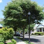
Car park around PJ Mould
Warburton Highway (Town Centre)
Warburton Highway (Link and Field)
Key plan
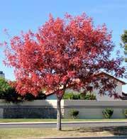
Botanical name Zelkova serrata 'Green Vase' Pistacia chinensis Eucalyptus ficifolia
Common name Green Vase Japanese Elm Chinese pistachio Red Flowering Gum



Mature height x width
Native/Exotic Exotic Exotic Native
Deciduous/ Evergreen Deciduous Deciduous Evergreen

Flower season & Colour Inconspicuous (foliage turn yellow & red in Autumn) Spring, Insignificant yellowish-green Spring, Summer, Red
Note Excellent uniformity and branch structure
Same species as “Memorial Plantation” on Warburton Highway
Wandin North Town Centre Masterplan 23
14m x 10m 8m x 6m 8-10m x 5-8m
ACTIONS AND ESTIMATED COSTINGS
All projects shown below are currently unfunded and require advocacy and/or application for funding.
Action:
1 PJ Mould Reserve and surrounding car park - Concept Design Development, Detailed design documentation & Project management
2 Upgrading PJ Mould Reserve including potential war memorial relocation and providing gathering spaces
3 Upgrading Car park and footpath surrounding PJ Mould Reserve
4 Upgrading Greenglades Court Reserve Concept Design Development
5 Town Centre and Field - Concept Design Development, Detailed design documentation & Project management
- Design & Place
- Design & Place
- Environment & Infrastructure
- Design & Place
- Infrastructure Delivery
- Design & Place
- Design & Place
- Infrastructure Services
- Department of Transport and Planning
6 Installation of 2 signalised pedestrian crossings at Warburton Rail Trail and George Street.
7 Upgrading town centre car park, footpaths, furniture, roadside (kerb & drainage) and street tree planting. Extent of work is a section of Warburton Highway between George Street and Union Road.
8 Upgrading footpaths, roadside (kerb & drainage) and street tree planting. Extent of work is a section of Warburton Highway between Warburton Rail Trail and George Street.
9 Redeveloping the Field (vacant lot adjacent Warburton Rail Trail)
- Design & Place
- Infrastructure Services
- Department of Transport and Planning
- Design & Place
- Infrastructure Services
- Department of Transport and Planning
- Design & Place
- Infrastructure Services
- Department of Transport and Planning
$600,000 ($300,000 each)
Short-Medium $400,000
Timing terms:
- Short term = 1 5 years
- Medium = 5 10 years
- Long = 10 20 years
Exclusions:
- Design & Place
- Environment & Infrastructure Short-Medium $500,000
Total anticipated implementation budget: $2.8M to $3.0M
- Excludes anticipated State Government subsidies.
- Excludes Council capital works budget.
Wandin North Town Centre Masterplan 24
Responsibility: Timing: Cost Estimate:
No: Description:
Short $70,000
Short
$120,000
Short
$300,000
Short
$25,000
Short
$150,000
Short
Short-Medium
$700,000
Prepared by Design & Place, Yarra Ranges Council


Council recommends anyone having difficulties viewing or interpreting elements of this document due to accessibility needs to contact us for assistance
Published JULY 2023
© Yarra Ranges Council 2023

ABN: 21 973 226 0120
15 Anderson Street, Lilydale PO Box 105, Anderson Street, Lilydale 3140
Phone: 1300 368 333
Email: mail@yarraranges.vic.gov.au
Web: yarraranges.vic.gov.au
Wandin North Town Centre Masterplan 25


