

YUANLI JIANG
EDUCATION BACKGROUND
Nanjing Forestry University (2019-2023)
Landscape Gardening
Bachelor of Agriculture in Landscape Gardening
Overall GPA:88.74/100
INTERNSHIP EXPERIENCE & AWARDS
Nanjing JiangSen Architecture & Landscape Planning Design Co., Ltd. July-Aug.2022
Nanjing OuDe Landscape Engineering Design Co., Ltd. July-Aug.2021
Finalist of the 13th Yuanye Awards International Competition Organizing Committee Dec.2022

Excellent Student Secretary Award during 2021-2022 academic year of NJFU Dec.2022
The Third Prize of the 13th Yuanye Awards International Competition Organizing Committee Nov.2022
The First Prize of 2022 Creativity Competition for College Students in China Aug.2022
The Second Prize of the 2nd Ecological and Environmental Protection Competition July.2022
Excellent Student Award & Scholarship during 2020-2021 academic year of NJFU Dec.2021
THEME OF THE PORTFOLIO:TOPOLOGICAL RELATIONSHIP
My portfolio is concerned with topological relationships. In my view, topology is the balance and natural order that is maintained in the dynamic development of space. There are elements within the space that can control or influence this topology and the feeling that the space brings to people changes as a result. In my design, I mainly focus on elements such as materials, site mechanisms, plants, etc. By dismantling, combining and superimposing these elements, I create a topological connection within the space.
CONTENTS 01 02 03 04 05 "Texture" Duplication Continuous Green Dragonflies' Response
Other Works
for the
based on site textures Kai Tak airport design re-transformation
"Timber Skyline"
Transformation
abandoned factory
Ecological and industrial landscape design for the river island
The modular timber-frame residential building
"Continuous Green City" Kai Tak Airport Design Re-Transformation
VICTORIAHARBOUR
Location: Hongkong, China Type: Individual work Duration: 2021.12-2022.2 Skills: Gis/Ps/Rhino/AI/ID/Lumion
Aim&Objectives: continuous vegetation/ green rate/TOD system
The site is located in Hong Kong, China, a former airport that is currently not being used in a reasonable way. Hong Kong is a densely populated city where public and green spaces are gradually disappearing, and where residents demand more convenient transportation and public spaces with higher rates of green.
The design makes use of the TOD model of transport mode, with ecological green belts running through different functional areas to create a more convenient link between the city and people's lives. At the same time, the combination of point, line and surface forms of green cover effectively enhances the living environment.


With the Kai Tak Airport as the backbone, the rapid development of the surrounding area has created a city of flyovers. Now that the airport has been grounded, only Pier Park remains. Kai Tak is still waiting for a new lease on life.

Demographic analysis


Dense crowds need more convenient transportation.
Maximize the limited land area to build a more comfortable home.
Provide complete infrastructures such as medical, commercial.

Provide excellent indoor and outdoor sports sites.


Improve the barren environment and plant trees.
Provide resources for young children and the general public.


"
114.17E 22.33N Kai Tak YAYTSIMMONG KOWLOONCITY KWUNTONG station transport note 400m ridial site traffic route sea area maritime line Quay lines History development Spatial analysis 86000 30300 Non-domestic plot ratio:4-9.5 Kai Tak Land Planning Content Population of Kai Tak Office floor space 18.2 The Top3 contents: Recreational+Residetial+ Commercial Retail floor space Hotel floor space Number of residential units 5.1 6 53.2 23.2 13.7 109.3 59.6 8.5 31.2
Group problems Local residents Visitors Students Merchant Commuter Elderly people
housing
social
Improvements Main requirements human settlement transportation system
condition
equity
01


Continuous production landscape Green spaces in plan and elevation Production/stormwater treatment Diversified three-dimentional landscape Fair per capita green rate BUSINESS Super community Ordinary community STATIONS CULTURE RESIDENCE Greenspacerestorationstrategy TODsystemtransportmodel Socialequitystrategy Functional strategy Structural strategy-topological relations POINT ECOLOGY Green Tower Building Green Ladder Hub Stations Punctutate green space Linear green space Cluster-like green space Green Corridor Link Shuttle Trail Waterfront Park Green Faced Building Three-dimentional Corridor Function Centre PASSAGE FUCTION LINE SURFACE Spatial layout SPORTS CENTRE BUSINESS DISTRICT ADMINISTRATION CENTRE WATERFRONT PARK CRUISE SHIP PARK WATERFRONT PARK RESIDENTIAL AREA SPORTS CENTRE RESIDENTIAL AREA RESIDENTIAL AREA CRUISE TERMINAL CRUISE TERMINAL Space ascension
Vegetation and Road Connection Network
Master Plan
There are five TOD station buildings in the site.The traffic line formed by the five stations surrounds the entire former site of Kai Tak Airport.
Green Space Connection Algorithm
Vertical
Rooftop
Functional Ground
garden terrace wall greenery green belt sponge walls rooftop farm misplaced green falls slope catchment sunbathing area penthouse teahouse children’s playground greenhouse farm greenface theatre parking plaza movable landscape ecological fencing cubic farm
The site has been incorporated into the site in 16 different ways from four perspectives: vertical, roof, functional and ground level, thus increasing the greenery of the site.


Venue Analysis
High greenery residential area City farm
Tod station complex Sports centre Commercial sub-centre Medical centre Waterfront park Commercial centre
Large green roof residence KP106/KP107 Quay Port Park
Creeper
Overpass
Lianqing Cultural Palace
Tod integrated station building Organic Food Market
City Shed Organic Farm Administration Centre Sports Centre
Public Transport Route Green Corridor Connected Green Space Urban Farmland TOD station less than 500m
Residential Areas Amenities
Parks/Farms
N 300M 600M
I can get everywhere by public transport, which is much more convenient than before !


The fruits and vegetables grown in the community are enough to feed our family.
There are lots of events going on at the Station and I can't wait to join them!


 Diverse Transportation Community Farm
Versatile TOD Station
Diverse Transportation Community Farm
Versatile TOD Station
“Dragonflies' Response"
Ecological and industrial landscape design for the river island

Analysis of land types around the island Map of dragonfly distribution in China.


the long molefly the Ribbonfly
Location: NanJing, Jiangsu Province
Type: Academic/ Individual project Duration: 2022.4-2022.7
Skills: Gis/PS/Rhino/AI/ID


Aim&Objective: Ecological Restoration/ Water Purification
Jiangxinzhou, located in the Nanjing section of the Yangtze River, is facing serious water pollution challenges due to the irrational use of pesticides and fertilisers on farmland on both banks and the unreasonable discharge of factory wastewater.
Mountain Dragonfly
The three most common species of dragonflies in China are mainly found in the provinces around the Yellow River and Yangtze River systems. Of these, the Yangtze River basin has five areas where the yucca dragonfly is mainly found, where the water system is dense and of good quality.
Number of Species of Pests
mg/L
Number of Species of Dragonflies
An increase in Phosphorus, Ammonia and Nitrogen elements in the water column that affect the survival of dragonflies.
Total pesticide usage Total Phosphorus amount Total Ammonia and Nitrogen
habitats
11+moults nearly a year in the water
Dragonfly larvae Adult dragonfly

Why can't I see the dragonflies I used to see everywhere now? Worm eggs
Dragonfly larvae eat plankton and other pest insect eggs in the water
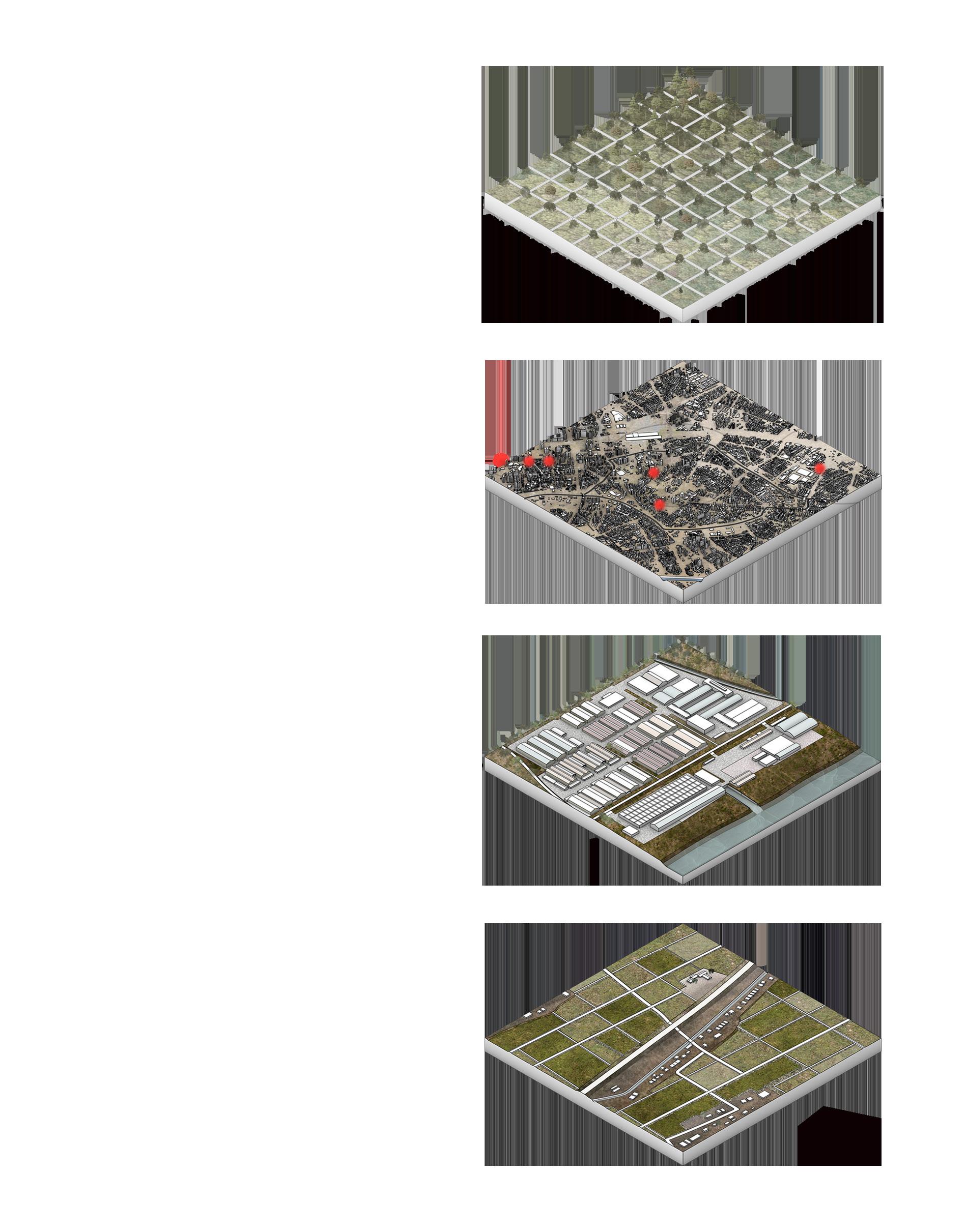
PHASE1 FARMLAND PHASE2 FACTORY PHASE3 RESIDENTIAL AREA

2013 2014 2015 2016 2017 2018 2019 2020 2021 02
According to my research, dragonflies live in different wetlands and are increasingly used as bioindicators to assess water quality and its changes. This design captures the link between dragonflies and water quality by reducing the use of pesticides and chemical fertilisers, while introducing native wetland plants for tertiary water purification to enhance the water bodies of the site, which can be visually reflected by the number of dragonflies
Cross
Wetland Artificial
Grassland Farmland Water
Factory
The development process of island
River Tunnel
ground
area
the blue-faced fly
Amphibious inthewater
The life cycle of dragonflies is closely linked to the water environment.
Docklands
Non-urban building land
Residential land Park green space Industrial land

Commercial land Transportation land Electricity supply land Stormwater facility land
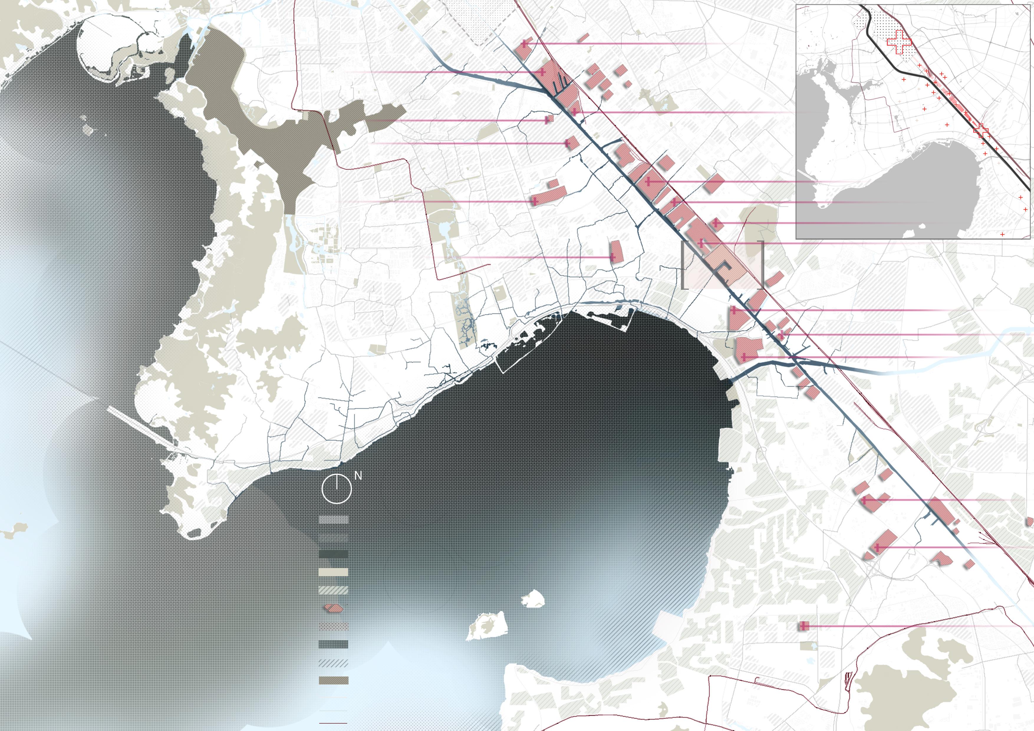
The government's plans for the river island, the central part of the site has been developed mainly for residential, commercial and educational uses, while the fringe areas of the island are currently unused. Therefore, the undeveloped area at the entrance to the Yangtze River Tunnel was chosen for the design and planning.


STRATEGY
SITE
pesticides
ecological problems fertilizer factory rubbish felling trees


water pollution soil pollution declining diversity of species transmission of diseases social problems
High levels of water eutrophication, especially Phosphorus and Nitrogen.
Using fish pond to reduce the use of pesticides and fertilizers, create a fruit-based fish pond industry.


Productive landscape
Highly polluted water quality
High levels of heavy metals in the water
Introducing native wetland plants and using the original topography of the site to create a threetier water purification system to purify water.


Fertilizer

Wetland vegetation
Purified water

Instability of water PH, Permanganate Index and Oxygen content
The introduction of the dragonfly as a water quality testing species visually demonstrates the effectiveness of water purification.
Iris Reed Tertiary water purification

Research based on the dragonflies


A.habitat B.vegetation C.water quality D.response


Life cycle of the dragonfly
Water quality
Number of the dragonflies
The site is wasted and unused
AFTER BEFORE Clean water and good ecological conditions. Insert industry and increase interaction
Site Vicinity Planning Analysis
PATTERN LANGUAGE
The site is planned into four main zones: ecological restoration zone, ecological buffer zone, ecological interaction zone and treatment effect experience zone. The fish ponds and mulberry planting areas within the site are retained while continuing the industry, and bird watching houses, dragonfly stands and other artefacts are added to increase interactivity.


Ecological restoration areas Shallow stream wetland Ecological floating island Ephemeral wetlands Terraced water purification Underwater fish restaurant Silt accumulation Ecological dykes Rainwater garden Sankey fish pond Permeable car park Bird watching treehouse Eco-education museum Sunken eco-playground Trestles linking patches Dragonfly conservation house Dragonfly entrance plaza
A B C D
A B C D ZONING MAP - STRATEGIES
Activity zone Intercept purification Wetland Embankment Embankment Biological observation Conserving species habitat Control water pollution Framework Ecological buffer zone Ecological restoration zone


N B' 3.6 1 1 6 11 16 2 2 7 12 17 3 8 13 18 4 9 14 19 5 10 15 20 3 18 19 20 4 5 6 7 8 9 10 11 12 13 14 15 17 16 Section A-A ' Waterfront trail Dragonfly bservation park Service centre Fitness trail Open ecological wetland restoration area Enclosed marina area Section B-B' Walking path Fish farming pond Fruit tree planting area Fitness trail Eco-interactive zone Wetland mudflat MASTER PLAN 100M 200M A B A 7.5 3.9 3.5 4.2 6.9 6.3 Sightseeing quay Dragonfly observation area Ecological car park Dragonfly sculpture plaza Permeable sports field Eco-education museum Angling centre Open-air display space Cruise terminal Yuet lin park Waterfront Flower Belt Plaza Entrance to tunnel Birdwatching house Habitat Park Service complex Complex industrial base Immersion restoration area Ecological interactive area Experience c entre Product processing restaurant
Today I dug out a lot of fertilizer from the pool.
I realise that the ecology of the area is getting better and better, birds and insects that I haven't seen before are appearing.


The water is so clear, I can see many dragonfly larvae !

Huaguang technology center
Sulfur dioxide

"Textures' Duplication"
Transformation of old factories based on site texture
Cargo ship maintenance center petroleum hydrocarbon,phospho rus,chromium,nickel,chloride,ca dmium,nitrogen,mercury,zinc
Aguatic products market
Chlorine
Wuxi fanggong sutomobile repair ltd. Formaldehyde,benzene and coal tar pitch
Wuxi chemical equipment ltd.. Cadmium,chromium,zinc,benzene,aldehyde
Wuxi software park
Cadmium,chromium,zinc,sulfur dioxide,mercury,carbon monoxide,dust
Wuxi storage and transportation ltd. petroleum hydrocarbon
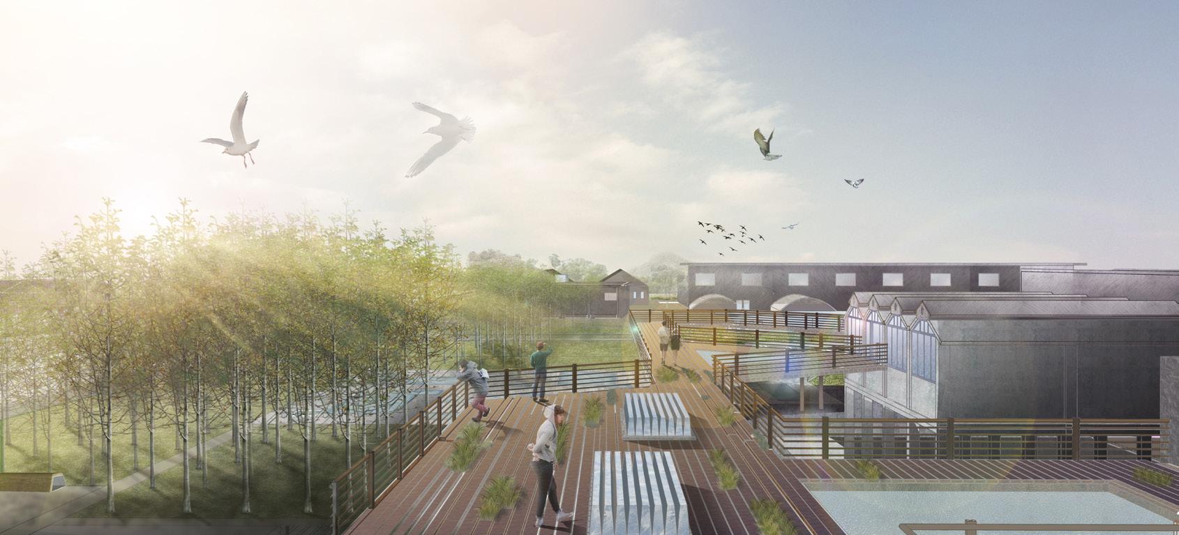
Location: WuXi, JiangSu province
Duration: 2022.6-2022.9
Type: Yuanli Jiang, Yixuan Zhou, Siruo Qu Skills: Gis/Rhino/PS/AI/ID/Lumion
Aims/Objectives: Site commemoration, Eco-restoration/Park design
The Wuxi Logistics Port is located in the downstream of the Beijing-Hangzhou Canal and the site is surrounded by a large amount of industrial heritage and agricultural land. At the same time, the site is located in an area where there are serious problems with metal contamination in the soil.
This design extracts the farmland, cultural and industrial texture of the site, combining and superimposing these elements to protect the potential industrial and agricultural features of the site, stringing them together to form hints in the site, while planting aspen trees and installing water purification ponds for ecological restoration to improve the soil contamination.

Real estate community
Wuxi Alps Electronics ltd. Cadmium,chromium,zinc,lead and lead vapor
Electroplating plant
Cadmium,chromium,zinc,ammonia
Wuxi Little Swan ltd. Cadmium,chromium,zinc
Paper mill
Chlorine
SITE
Wuxi shuangjie machinery manufacturing ltd.
Sulfur dioxide,dust,,zinc,chromium,cadmium
Hudong industry park
Dust,zinc,chromium,cadmium
Wuxi zhongguancun science and technology innovation park
Dust,zinc,chromium,cadmium
Suzhou yongxiang steel ltd. Sulfur dioxide,dust
Suzhou jinhe plastic ltd. Sulfur dioxide,dust
Italian industial park
Sulfur dioxide,dust,,zinc,chromium,cadmium
03
Wuxi ancient canal tourist resort Water area Green land Farmland Factory Zinc pollution Chromium pollution Cadmium pollution Natural reserve Main road The secondary road Railways
SITE Wuxi ancient canal Resort
Analysis of greenfield & farmland Analysis of cultural relics
Huangbudun Canal park Jiangjin park Sports park Taosha lane
Daffodils Central Park
BC495-610
Fuchai, king of wu dug the ancient waterways. Then, emperor Sui Dynasty dredged and widened the waterway.
1300-1400


The Grand Cannal promotes the prosperity of Wuxi Rice economy. Rice is planted in the farmland along the river
Analysis of industrial plant

Agricultural Texture
1978
The economic growth comes a variety of pollution. Waste gas from factories causes air pollution, sewage from streams causes water pollution, and industrial wastes continue to pollute the soil.
1600-1900
The navigation function of the Grand Canal directly contributed to the prosperity and development of Wuxi's industries, such as rice markets and handmade products such as kilns

2000
A series of ecological policies and measures have been implemented.
In the early days of primitive agricultural society, this was a large area of wasteland farmland that was cleared for basic agricultural activities.
After the reform and opening up, industry began to develop rapidly, and a lot of farmland was used to build factories.
With the development of industry, the rapid expansion of the city gradually developed towards Taihu Lake. Industrial and domestic sewage was discharged into Taihu Lake, leading to the gradual deterioration of the ecology of Taihu Lake.


Ecological Texture Cultural Texture Industrial Texture
SITE TIME & TRACING SOURCE
greenfield Framland Cultural sites
Factory
HuiTown HuiPark Machine gallery Nanqiao Street Wuxi museum Xiadian qiao port
Cave ruins
Ecological Texture
Induatry Texture
Cultural Texture
Texture
from time & space
Agricultural
Space line Time
Texture
line
STRATEGIES APPLIED TO SITE DESIGN


ANALYSIS STRATEGIES CONCEPT
Extend the cultural charm of the upstream and downstream reaches of the ancient canal.
SITE
From farmland to industrial intensive areas, combining local history, culture, farmland and industrial structures, effective ecological and memorable measures are taken to develop the site.
MORPHOLOGY CHANCE
The site is surrounded by farmland, green space, industrial and cultural sites. But as the factories moved out, the farmland was abandoned, the attraction of the site diminished, the value was obscured, and the various textures within the site were isolated and could not be integrated.


Industrial pattern


Cultural pattern

Ecological pattern Agricultural pattern


water storage
assessing & screening
planting water network damage

10% 20% 5%
A.Polar cultivation B.Ecological water purification shapes of farmland


15% 15% 60% 60% 30% 80%
extension enclosing Rebuilt industrial plant A.Bridge connection B.Protection&Restoration of cultural sites

retention & replacing bridge contact bridge repair develop

function & implanted
Nearby farmland Railway Hoist crane Workshop Transport by water factory greenfield

Process of farmland change simplify distinguish
cultural part agricultural part residential area canal railway

farmland ecological part industrial part
In the spatial investigation and time tracing of the site, I reorganized the texture of the four elements of culture, farmland, industry and ecology, integrated the urban memory, awakened people's sense of memory and identity of the city, and created a waterfront industrial zone with unified production value, ecological value and living value.


0 0.5 1.0 1.5 2.5 2.0 2.5 3 3 0 50 100 150 M 5 1 Poplar Grove Soil Restoration Nursery Area 9 Net Pool 10 Sunken Rest Terrace 11 Waterfront Steps 2 Industrial Sites 3 Viewing Bridge 12 The Memorial Museum 4 Waterside Terrace 13 Sports Field 14 Children’s Park 15 Landscape Corridors 16 The Farmland 5 Plant Breeding Base 6 Poplar Tree Pile Square 7 Experimental Center for Plant 8 The Parking Lot Master Plan -- Combination of Culture, Ecology and Agriculture 1 2 9 4 10 11 3 7 12 6 8 16 15 14 12 13 1 Building Materials Company Logistics Warehouse Transport Company Machinery Company Traffic Network & Plant Analysis Main Road Secondary Road Tertiary Road Viewing Bridge Water Purification Plants Waterland Plants Aspen Functional Partition Analysis Ecological Remediation Accelerant Culture Accelerant Sports Area Water Purification Accelerant Farmland Accelerant Contour Analysis Contour Buildings in the Site Analysis Retain Gantry Crane Sculpture New Buildings Retain Buildings


Asphalt Industrial zone Ecological pavement Hydrophilic plank road Platform Steel Lesco Wood Permeable Brick C30 Concrete Q235 Steel The Stone Cage Clear Concrete Clear Concrete Green Brick Grass Rubble Plantsedimentation Granary Carry out Hard bank Farmland Natural revetment Primula malacoides Franch F.atroputpurea Pittosporum tobira (Thunb.) Ait. Ophiopogon bodinieri Levl. Thalia dealbata Magnolia Paulownia Sieb. et Zucc. Nelumbo nucifera Gaertn. Malus halliana Koehne Hemerocallis citrina Baroni Grille Activated sludge process Biological membrane Aeration Inclined sedimentation Polluted land Plant poplar Dominant poplars Every 35 meters Identification & Selection Creating space for activities Dead trees Transplanting Excavation and Removal


Agricultural Part Industrial Part Cultural Part 50MM Sesame Grey Granite Tread Double-wall Corrugated Pipe Access to Rainwater Pipe Network 30MM 1:3 Cement Mortar Bonding Layer 100MM C20 Plain Concrete 100MM Gravel Mattress Reinforced Concrete Wall 30MM Flamed Granite ile Planting Soil Practice of the planting pool along the river 1:20 Selected construction drawing
"TIMBER SKYLINE"
The Modular Timber-frame Residential Building.

Location: Chicago, United States
Type: Individual project Duration: 2022.10-2022.11


Skills: Gis/PS/AI/ID/D5/Keyshot

Aim&Objective: Timber Frame Construction ,Modular,the Future of Housing


The site is located on the banks of the river in Chicago and has a good infrastructure around it, with plenty of room for development and is well suited for residential property. Modular construction allows for efficient and environmentally friendly construction of houses.

The design of the modular building seeks variation in form and house type within a uniform form . At the same time, according to my research, wood construction has many advantages and will become the dominant material in the future housing market. Wooden construction is carbon-solid which could help combat some climate events such as global warming

SITE Carbon
Extreme
Unsustainable resources Number
2017 04
emission
climate
of timber buildings worldwide 2022 2021 2020 2019 2018
Location
feeling depress deep foundation shallow foundation warm five
single
resistance digging digging
transport spent
save 45% time and
cost carbon
prepared
steel/concrete wood limited
co2/co reserve co2
choose modular construction? 3.6KM
7 3 35 65
In recent years, more and more natural disasters have been occurring on the planet. This has led to an increased focus on the topic of a sustainable environment. year
workers
worker weight:1
weight:1/5 carbonised fireproofing poorly fusible fireproof
plenty of time
machines lifting mixing and concreting materials
emission
wooden boards time
mines
Why
In summary, modular timber buildings are more efficient, less costly, environmentally friendly, more resistant and with better visual effects.


Conventional Layout -dense/packed -no communal spaceace Shuffling Units -introduce layers in between -increase permeability Divide/Combine Space -different styles -meet demand Tapering -stability -create variety of views step 4 step 4 step 2 step 1 45。 Block Derivation Category Three-bedroom flat Two-bedroom flat One-bedroom flat
TYPICAL PLANS
Typical plan - low rise
Each floor has private and public areas where people of different professions live together. The public activity areas start from the lifts where there are cinema spaces, relaxation bars, 24-hour vending machines, etc., allowing people to live in more open spaces, reducing the distance between neighbours and bringing residents closer to each other. However, the interior of each unit is a private area, free from interference with each other.

Typical plan - mid rise

Typical plan - high rise

There are communal spaces on each floor for residents to move around and the lift has a wide view out to the river outside. Residents socialise in the public spaces to strengthen relationships and eliminate feelings of isolation.
 E-gamer Blogger Photographer Programmer Artist Chemist
People of different professions living together
E-gamer Blogger Photographer Programmer Artist Chemist
People of different professions living together
 The form was inspired by the LuBan lock.


5
OTHER WORKS
--
Blackboard painting Illustration work Photographed in Ya'an Grand Canyon Photographed at the sacred site of Muya in Sichuan Province Taken at
Mountain in Lijiang
Hand-made models: -- model for the waterfront park(design work) -- model for Frederick J. Smith house
model for ecological islands in the river
Jade Dragon Snow
Leach painting - inspired by Chinese Peking Opera