
WI.25 DESIGN PORTFOLIO
01. PlayMart (APA Design Competition) Spring, 2024 University of MURP Student
04. Beacon Park Exercise Fall, 2019 University of Undergraduate
AARON JOHNSON
Masters Student
- Urban & Regional Planning ‘25
- Urban Design ‘25
Taubman College
University of Michigan
07. Tripoli Go Spring, 2018 College for Creative Undergraduate
(APA Student Competition)
Park 3D
Connecticut
Undergraduate Student
Creative Studies
Undergraduate Student
02. Dequindre Cut Joe Louis Greenway Extension Spring, 2022
Independent Project
05. Sacred Heart University Campus Entry Summer, 2019
The S/L/A/M Collaborative L.Arch. Intern
08. Doomsbay Summer, 2017 UC Berkeley Summer DISC* Student
03. Sauk Trail East (Undergraduate Thesis) Spring, 2021
University of Connecticut
Undergraduate Student
06. Emory University Rollins Campus Corridor Summer, 2019
The S/L/A/M Collaborative L.Arch. Intern
09. Other Works
- Visual Communication - 3D Works - Generative AI Imagery
01


PlayMart
University of Michigan
Spring, 2024
Submission for the American Planning Association’s 2024 Student Design Competition. Teammates include Allison Yu, Xuanshu Lin, Rebecca Griswold, and Elyse Cote. Unless otherwise noted, all works shown are my own contributions.
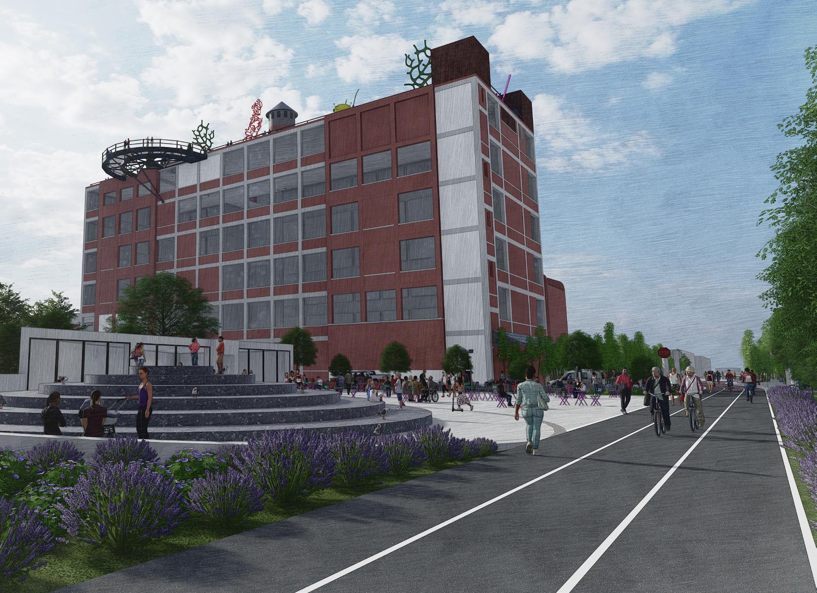
PlayMart is all of Minneapolis in one block, and one block accessible to all of Minneapolis. Decades of incremental efforts by the community and decisions made by the city have culminated in a one of a kind site.
Although PlayMart is a dramatic departure from current conditions, it actually represents a very organic urban response to its context. Disrupting Nicollet Avenue, one of the city’s critical historic corridors, for a Kmart was an unfortunate change to the urban form. However, the arrival of Kmart produced a serendipitous side effect. While the big-box retailer wasn’t constructed with the goal of
Diagrams created collaboratively with Allison Yu.
decreasing traffic volume, it catalyzed an experiment by removing vehicles from a significant Minneapolis thoroughfare. Other cities have gone through this process more intentionally, but the lesson remains the same: where cars have been removed, there is no reason to reintroduce them.
Surprisingly, Kmart provided Minneapolis the canvas and momentum to explore alternative urban forms in the absence of vehicular traffic on Nicollet. The city has successfully woven a stunning greenway, extensive bike infrastructure, and a modern bus rapid transit line within a short walk of the site. These achievements showcase Minneapolis’ unique capacity to foster sustainable, multi-modal lifestyles.
All that’s missing is the capacity for more people to live, work, create, and play at the confluence of these invaluable assets.


Midtown Greenway entrance from the 1st Ave bikeway.

Nicollet Ave is reconnected via below-grade, dedicated bus lanes.


1st Ave retail hub with active mobility access.

Lake St retail corridor with stair access to bus platforms below.


1st Ave and Lake St cafe area facing Orange Line (BRT) station.
Entrance to underground truck docking and parking garage.
Residential
The team proposes amending Minneapolis’ CM4 Zone to allow residential uses on the ground-floor level. The prohibition of residential units along streets prevents the conglomeration of diverse housing styles and uses. For example, integrating some townhouses at street-level intentionally fosters a neighborhood atmosphere and aesthetic, rather than a strictly commercial district.
Visceral
corridor towards Downtown skyline from elevated walkway.


View


02
Dequindre Cut Joe Louis Greenway Extension
Independent Project Spring, 2022
Establishing an exciting community asset by taking advantage of an abandoned building’s situation alongside Detroit’s planned extension of the Dequindre Cut greenway.
The proposed Joe Louis Greenway loop will integrate the exisiting 1.6 mile Dequindre Cut rail trail, doubling its length from its current terminus at Mack Avenue northeast to E Milwaukee Avenue.
The additon will repurpose the same underutilized freight railway track owned by Conrail.
This proposal coordinates the redevelopment of two parcels adjacent to the Dequindre Cut extension. The greenway frontages of the sites straddle E Warren Avenue and create plazas with pedestrian and cycling ammenities for trail users.


The greenway crosses Warren at-grade with traffic controls that prioritize non-vehicular mobility via stop signs, warning lights, and a cycle track at sidewalk-grade along Warren Ave.

The site south of Warren involves new construction of a single story retail/restaurant building with a bikeshare station and outdoor seating.
The site north of Warren repurposes a large, vacant industrial building as a whimsical destination inspired by St. Louis’ City Museum. Its path frontage adds seating and greenery for trail users.


03
Sauk Trail East
University of Connecticut
Spring, 2021
Completed as an undergraduate thesis for my Individualized “Sustainable Urban Design” program. Faculty mentors included Mariana Fragomeni, Carol Atkinson-Palombo, and Norman Garrick.


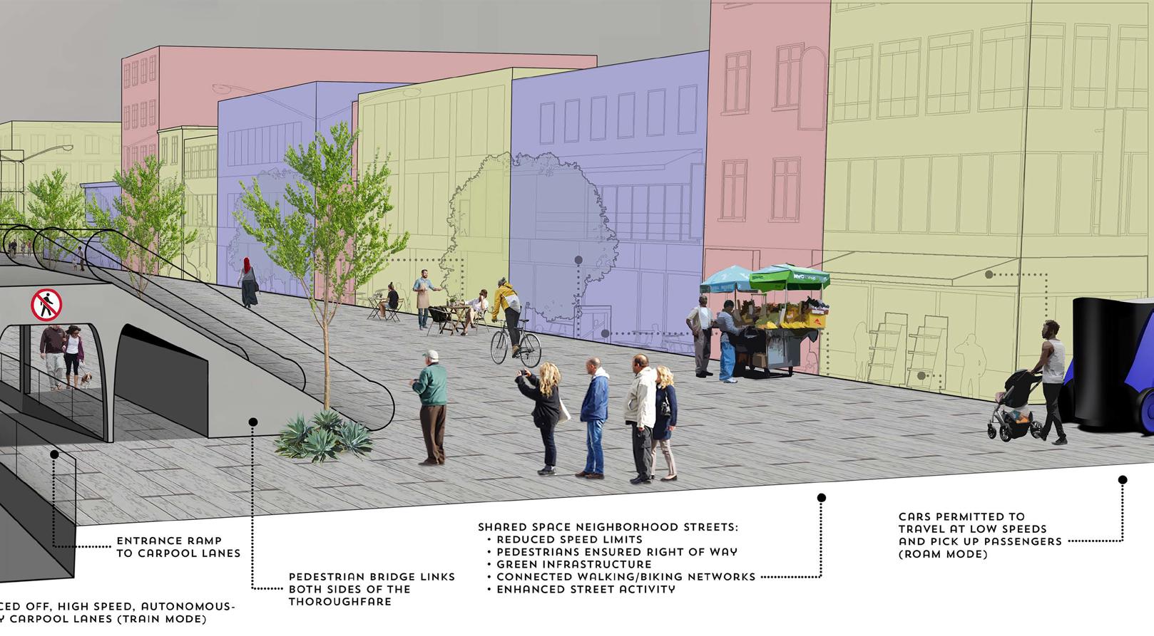
The urban mobility research and design study follows a proposal for the world’s first public connected autonomous vehicle corridor (CAV-C). The intended route links Ann Arbor to the City of Detroit, whose residents have faced severe historic and ongoing issues surrounding transportation equity and access. The project examines CAV-C’s potential to relink Detroit communities via changes to land use, modal choice, and intermodal prioritization.
The full project is viewable at: issuu.com/aaron.johnson/docs/executive_ summary_pages


In January 2020, Michigan, vehicle (AV) industry, requested corridor. The 36-mile roadway and arterial routes on I-94 the startup Cavnue was Corridor (CAV-C) concept.
Cavnue claims that stuck interactions with human efficiency, and cost benefits CAV-C must address real-world question:
Will the project address

Michigan, to cement its role as the home of the autonomous requested proposals for a public use autonomous vehicle roadway will link Detroit and Ann Arbor following freeway I-94 and Michigan Avenue, respectively. In June 2020, was selected to develop the Connected Autonomous Vehicle concept.
stuck among regular traffic and prone to unpredictable human drivers, AVs are prevented from realizing their safety, benefits on existing roadways. The state of Michigan asserts real-world personal mobility challenges, thus begging the
Research involved historical contextualization, geograhic analysis, contemporary public opinion, and overlap with existing relevant plans.
Each process contributed to the opportunities and constraints analysis, which maps out key findings about Detroit neighborhoods along the planned CAV-C routes. The green stars on the map below mark the locations determined to warrant prioritization and intervention based on need, demand, and potential.
The first intervention centers on the intersection of Michigan + Livernois, two avenues targeted with proposals for bus rapid transit integration (see next page).
address the transportation needs of Detroiters?
The second intervention focuses on the Lonyo Street connection between I-94 and Michigan Ave, along the route of the proposed Joe Louis Greenway (see the page after next).


Intervention 1
The Michigan + Livernois intersection is slated to become a bus rapid transit (BRT) node in Detroit Future City’s proposed transit network.
The transit hub’s “boomerang platform” layout allows both BRT lines to share platforms and creates only one elevated crossing point for all four travel directions.
Because of the immense width of both avenues, the node can support the entire architecture within the intersection’s footprint. To accomodate the building, the street space dedicated to regular traffic is narrow and only permits traffic from one direction at a time. Intelligent signalling prioritizes pedestrians, cyclists, transit/AVs, and lastly, regular vehicles.
Cycle tracks along each avenue improve bicycle access for the surrounding neighborhoods and encourage transit riders to use personal mobility options for first and last mile journeys to and from the station.


Intervention 2
The Michigan/I-94 + Lonyo site ties together the planned Joe Louis Greenway with a Detroit Future City proposal for carbon forest buffers along the city’s freeways.
Detroit’s I-94 service drives are consistently underutilized, with AADT around a quarter of the city’s average. They can be reclaimed to bisect the JLG loop with a greenway connector, which would provide non-motorized access to the CAV-C transit stops along I-94.
Central boarding gives access to the overpass and greenways above. This connection allows transfers between express and local BRT service on I-94 and Michigan Ave, respectively.


04
Beacon Park 3D Exercise
University of Connecticut
Fall, 2019
Completed as a landscape architecture class modeling exercise.
Tasked with recreating a park of my choosing, I refined my landscape architecture workflow while developing this Beacon Park (Detroit) study. The process involves site context/analysis in GIS, layout in AutoCAD, construction in SketchUp, and rendering in Lumion.
I have applied this workflow to most urban and transportation design projects since.


05
Sacred Heart University Campus Entry
The S/L/A/M Collaborative Summer, 2019
Completed as an assignment while interning for SLAM’s landscape architecture studio.
SLAM was tasked with reimagining SHU’s campus as the school dramatically expands. Redesigning the main entrance was anticipated to be a future assignment for the landscape architecture studio. I kicked off the project’s schematic design.
The client’s objectives involved the extension of the campus standard wall to the entry and visibilty improvements toward Park Avenue from the security booth. Design goals focused on traditional iconography, street-facing presence, and extending a welcome to the surrounding Fairfield and Bridgeport communities.


06
Emory University Rollins Campus Corridor
The S/L/A/M Collaborative Summer, 2019

Completed as an assignment while interning for SLAM’s landscape architecture studio.
SLAM was hired by Emory University to design a new building for the Rollins School of Public Health along the “Life Sciences Corridor.”
The project scope expanded to include an update to the section of the pedestrian corridor surrounding the new facility. Emory wanted the site to include a garden to memorialize a former donor to the college, nodes at key pedestrian entrances and intersections, and new service and emergency access for vehicles.
All work on the design and modeling of the building itself was completed by SLAM’s architecture studio.


07
Tripoli Go
College for Creative Studies
Spring, 2018
Completed as an undergraduate term project for Transportation Design Exterior Studio.
The scope of work assigned involved vehicle exterior design, which became the foundation for a broader exploration of a future Mobility-on-Demand system in Tripoli.
Oil products make up 97% of Libya’s exports, making it the nation most dependent on oil production in the world. Libya also has the world’s highest rate of road fatalities per capita. As global oil demand declines, the Libyan people will need a more diverse economy and safety improvements to transportation infrastructure.

takes advantage of the vehicle’s design and autonomous operation to optimize on-demand routing.
Users can hail any nearby vehicle. When that vehicle joins a modular platoon in “train mode,” passengers are directed to change cars. The result of redistributed riders is the consolidation of desitinations according to route efficiency.


Could a disruptive investment in the future of autonomous mobility help to facilitate both?


Higher Speed

Train Corridor
08
Doomsbay
University of California Berkeley Summer, 2017
Completed during CED’s Design + Innovation for Sustainable Cities summer program, alongside teammates Tian Yuan, Haley Zapolski, and Tianyi Xu. Works shown are my own contributions.
San Francisco’s Mission Bay neighborhood is threatened by rising sea levels. Built on bayfill that replaced historic wetlands, the area is particularly vulnerable to the effects of climate change.
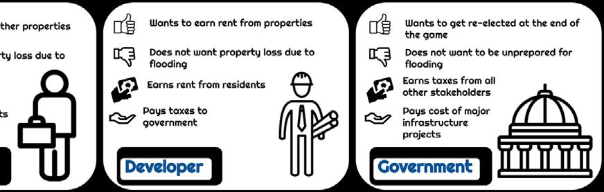
Doomsbay is a board game that allows players to simulate the roles of local residents, businesses, developers, and the government. Each stakeholder must balance their competing interpersonal interests with the imperative to build climate resiliency for Mission Bay.

After the final round, a dice roll determines the 100-year sea level rise. The enclosed well the neighborhood and its residents would fare. Outcomes reflect players’ abilities
Players add construction pieces that either generate wealth or mitigate the impacts of flooding with physical water deflection or absorption.

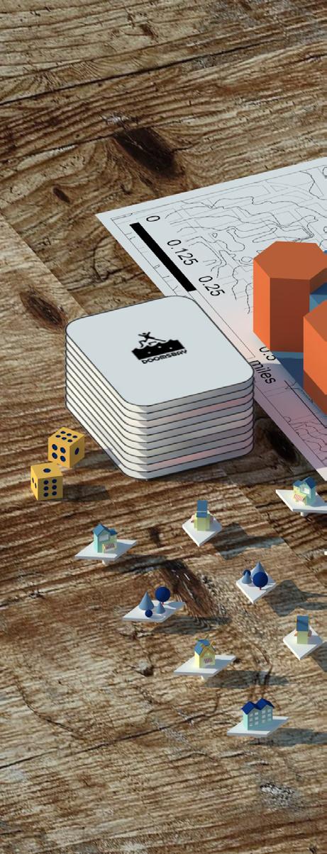
enclosed game board is flooded with the corresponding volume of water to test how abilities to balance strategic individual priorities and collaborate on shared objectives.


09
Other Works
On this page:
2D and 3D works completed during the College for Creative Studies’ Transportation Design program
On the following two pages: Digital artwork created using AI-based and traditional Adobe Creative Suite tools


