4 minute read
9. DESIGN DEVELOPMENT

1st Draft:

Advertisement

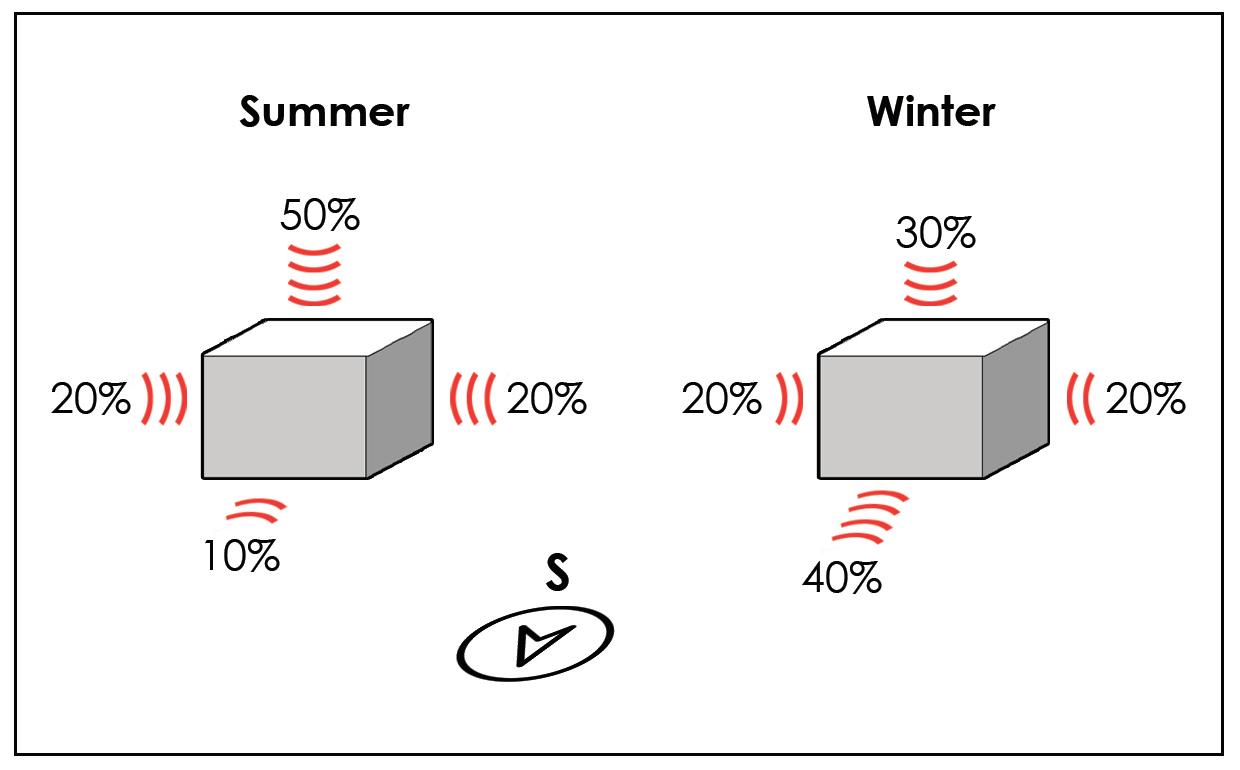
The design journey started with me going with the easiest approach, which was to make two types of blocks; one with type 1 & 2 houses and one with type 3 & 4 houses. These blocks were meant to resemble a traditional Ladakhi house with a central public terrace which may be used as a greenhouse during winters to warm up the adjacent blocks and also terrace farming. The indoor layout of the houses however, was still very western which we are familiar with. The main aim while figuring out the zoning was to keep all the living areas of the house towards the South i.e. the living and bedrooms, whereas the kitchen, dining and store could be towards the North side. The site planning was done according to the basic theories of neighbourhood planning where there’s no through road for vehicles to cross the site so that only the residents enter the inner roads, the commercial services were kept at the edges and the public areas like parks were at the centre so as to be easily reachable to all. The blocks were equally distanced so that they don’t block each other’s sun and the higher rated blocks were at the south side with a better view.


The first draft of the site plan was too basic and wasn’t creating any interesting communal spaces which are a necessity, plus all the blocks were too scattered and we required a more compact design. I decided to try a hexagonal grid where massing woth be placed on 4 of the 6 sides of each hexagon such that no block’s sun is blocked but this setup would require too much of cutting and filling which means a high carbon footprint; Also, it was too inorganic which is not a feature of traditional settlements in Ladakh. So I moved on to try massing which curves along the contours of the site. Row housing was preferred over clusters because in row housing every house recieves sunlight equally with blockage. The roads were kept to the edges and the centre was completely pedestrianized.

This draft was further developed keeping the indoor layouts similar as before. The valley cutting through the site from North to South-east was turned into green zone or parking with would help in mitigation against flash floods if we line both side of the valley with trees, the water would flow through the valley towards the open area at further South without damaging the buildings. Social infrastructure was added such as labrary, art gallery, and a sports club. The problem with row housing would be that it divided the site into long public zones with low visual connectivity. So I decided to rise the row housing of type 1&2 higher supprted by stilts with cores at proper intervals and clusters of type 3&4 at nodes as shown in the sections on the right. This established physical connectivity but visual connectivity was still low, plus we had unused space under the stilts.


The row housing units’ layouts were evolved into a more traditional Ladakhi style with an open kitchen combined with living/dining and a separate sun-room. Units were removved at certain public nodes to create more visual connectivity but it still wasn’t enough. Also, the access to the row housing was a corridor right in front of the living areas of the houses which created a huge privacy issue. Furthermore, there were still no smaller scale communal areas.


The site planning clearly required clusters to form smaller scale public areas within them. A cluster was formed as shown in the top-left diagram such that it creates a neighbourhood spacce in the centre while still maintaining the blocks’ orientation within a 30° range from true South. The placement of these clusters was along the contours to minimize the cut and fill while maintaining a proper distance. The valley still had the larger open areas flowing into the smaller neighbourhood streets. Parking was broken up into smaller parts to reach closer to all blocks and pedestrians street were widened to be used in case or fire or medical emergencies to reach all cores. House layout was kept similar while increasing the efficiency by reducing the number of cores and circulation area.