ABPL90130 Planning Law & Statutory Planning ASSIGNMENT 2 – Planning Assessment

Lee Ka Sin Adelaide (1381024)
Word count: 3246 (3000 + 10%)

ABPL90130 Planning Law & Statutory Planning ASSIGNMENT 2 – Planning Assessment

Lee Ka Sin Adelaide (1381024)
Word count: 3246 (3000 + 10%)
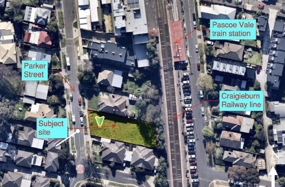
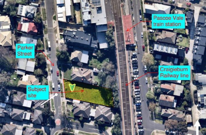
The subject site at 9 Parker Street, Pascoe Vale, is a parallelogram-shaped lot located on the eastern side of Parker Street, between Gaffney Street and Hayes Parade. It is positioned approximately 10 meters from the Craigieburn railway line, on its western side. Currently vacant, the site covers an area of approximately 756m² and slopes 500mm from east to west. The property features a 17.0-meter frontage along Parker Street with side boundaries measuring 46.0 meters.
Key Information Details
Application number MPS/2022/908
Subject land 9 Parker Street, PASCOE VALE VIC 3044
Total site Area 756 Sqm
Title details Lot 6 on Plan of Subdivision 006170
Proposal Construction of five units (1 dwelling each) of 3-storey townhouse on a vacant lot
Each unit will include garages on the ground floor, living areas on the first floor, and bedrooms on both the ground and second floors.
The applicant has provided a concept image of the proposal:


Planning Policies and Controls – Permit Triggers
Zone
Clause 32.07 - Residential growth Zone (Schedule 2) Overlays
Clause 45.06 - Development contributions plan overlay (Schedule 1)
Clause 43.02 - Design and development overlay (Schedule 24)
Clause 45.09 - Parking overlay (Schedule 1)
Statutory Planning Controls and Permit Triggers
32.07 – RGZ
-A permit is required to construct two or more dwellings on a lot. A development must meet the requirements of Clause 55. (32.07-5)
-Schedule 2 varies the Clause 55 (ResCode) requirements for standard B6, B8, B13, B17 and B28
43.02- DDO
- A permit is required to construct a building or construct or carry out works (43.02-2)
- Schedules 24 specified building design requirements for neighbourhood centres (see assessment session)
45.09- PO
-Pursuant to Clause 3.0 of PO1, rate in Table 1(Column B) in Clause 52.06-5 applies to calculate the required car parking spaces
-A permit is not required as below:
Use Column B Column C Proposed Dwelling 1 To each one or two bedroom dwelling - Five two-bedroom dwellings, each with one parking space in a single garage
Required rate: 5 x 1 (2-bedroom dwelling) The proposal complies.
(Open study room in Unit 1 GF doesn’t have a door so is not considered a room)
Planning Policy Framework
Clause 11 – Settlement
• 11.01-1S – Settlement
Clause 13 – Environmental risks and amenity
• 13.07 – 1S – Land use compatibility
• 13.07-1L - Discretionary uses in Residential Zones
Clause 15 – Built Environment and heritage
• 15.01 -1S – Urban Design
• 15.01- 2S – Building design
• 15.01-2L-05 - Environmentally sustainable development
• 15.01-4S Healthy neighbourhoods
• 15.01-4R Healthy neighbourhoods – Metropolitan Melbourne
• 15.01-5S Neighbourhood character
Clause 16 – Housing
• 16.01-1S 9 Housing Supply
• 16.01-1R Housing supply – Metropolitan Melbourne
Clause 18 - Transport
• 18.01 -1S Land use and transport integration
• 18.02-2S Cycling
Clause 19 -Infrastructure
• 19.03-1S Development and infrastructure contributions plans
• 19.03-3S integrated water management
Local Planning Policy Framework
Municipal Planning Strategy :
• Clause 02.01 – Context
• Clause 02.02 – Vision
• Clause 02.03 – Strategic directions
• Clause 02.04 – Strategic framework
Local Planning Policies :
• 15.01 - 1L Urban design in Merri-bek
• 15.01-1L Vehicle access design in Merri-bek
• 15.01-2L Building design in Merri- bek
• 15.01-2L Building design in Neighbourhood and Local Centres
• 16.01-1L Home in Merri-bek
• 18.02-2L Cycling in Merri-Bek
• 18.02-4L Car parking in Merri-Bek
• 19.03-3L Water supply, sewerage and drainage in Merri-Bek
The proposal responds positively to state policy directions by delivering well-located housing opportunities that integrate land use, transport, and local context (11 & 11.01-1S).
Policies are achieved through :
1. Increase supply of well-designed housing with high level of amenities in growing residential areas. Supports a city of 20-minute neighborhoods close to existing services and public transport (15.01 & 16.01)
2. Responds to local urban context and enhances public realm with a pleasant and safe pedestrian experience (15.01-1S & 15.01-2S)
3. Support environmentally sustainable and safe communities, design and construction addressed to energy, water, and ecology efficiency (13 & 15.01) , stormwater catchment area response to integrated water management (19.033S)
4. Support neighborhood's needs and well-being through dwellings with sufficient external and internal amenities, landscaping that compatible with the surrounding area (13.07)
5. Provide dwellings with adequate supply of bicycle parking spaces which encourage sustainable transport modes and support active living (18.01-1S & 18.02-2S)
6. The development under DCPO supports the implementation of development contributions plans through Levy contributions. (19.03-1S)
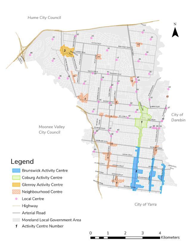
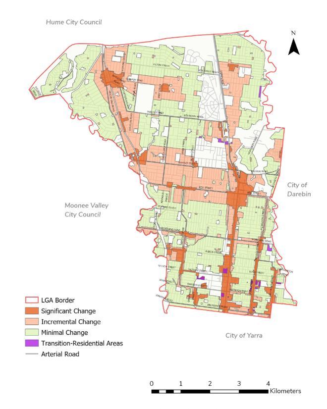
The subject site is located within the neighborhood center and area identified for significant housing development (02.04) to accommodate strong population growth (02.01& 02.02), built-form outcomes are determined by amenity and neighborhood character. The proposed 5 three-storey dwellings at this location is proximity to public transport and service (02.03) , considered consistent with the policy direction within the municipal planning framework.
The proposal responds to the relevant local policies :
1. Appropriately responds to the existing and emerging streetscape and neighborhood character :
- A three-storey dwelling is consistent to surrounding lower-rise buildings, particularly along Parker street (15.01 – 1L & 15.01-2L)
- Simple pitched roof on the top level will not dominate the streetscape
- Design incorporates materials similar to the surrounding buildings integrate to the established neighborhood character (15.01 – 1L)
- Reasonable street and side setbacks that mitigate the visual intrusion or amenity impacts (15.01 – 1L)
- The undercover garages that do not dominate the streetscape (15.01)
- Adequate landscaping around the perimeter (15.01-2L)
2. Overall responds to environmental sustainable policy and stormwater management policy in buildings design and construction: (15.01-2L-05)
- Provision of roof stormwater catchment area connecting to the 3000L water tank to each dwelling and recycling system in the Rear Bin Store support the water and waste management (19.03-3L)

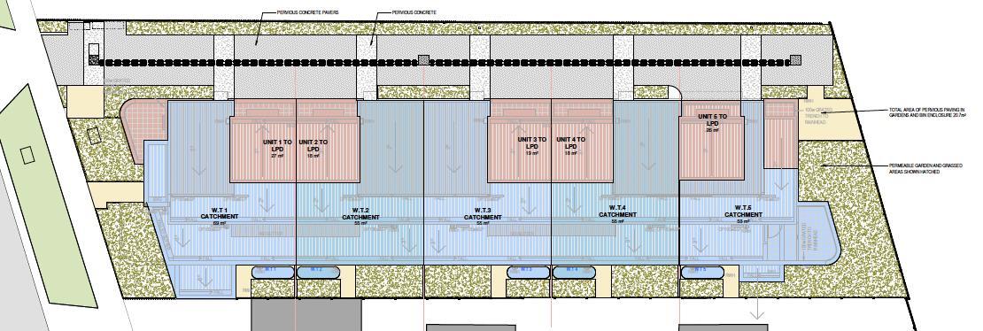
- On-site electricity generation to each dwelling by a 1.5 kW photovoltaic array support use of sustainable energy resources, 4-star reverse cycle heating, cooling, and energy use of amenities are designed to achieve energy efficiency
- Bicycling parking space with a 32A electric vehicle charging station provides convenience for residents and promotes the use of sustainable transport (18.02-2L & 18.02-4L)
- Tree retention (front setback), establishing of a tree protection zone, and use of advanced planting methods are respectful to biodiversity (12.01 -1L)
3. The shared driveway with adequate space and separate undercover garage provides safe Vehicle access and improved the urban environment (15.01-1L)
45.06- DCPO1
Site is indicated as area 7, Pascoe Vale. Residential development is subject to the Development Infrastructure and Community Infrastructure Levy specified in Table 2 Applicable rates are identified in the application.
43.02 - DDO24
Building height 13.5m, 4 storey

Side setback
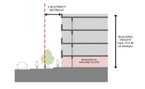
Figure 9: Front setbacks for residential ground floor
-Primary outlook (living areas): 4.5 metres
-Secondary outlook (bedrooms, kitchens)/no outlook: 2 meters
-Planted with trees (Conjunction with Cl55 Standard B17 in RGZ2)
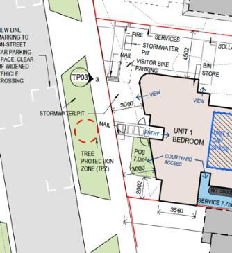
Site plan - TP04.1 [C]
Primary North East
Secondary North South GF 4.5m 2m
- 3.7m 2F 4.6m 6.2m
(Shortest distance indicated)
-Trees plant in both side
Rear setback - Consistent with Cl55 Standard B17 in RGZ2:

Figure 9 : Rear Building Setbacks
Y
-0.1m difference in 1F Livingroom outlook (4.4m) consider reasonable with little impact
N (3.2 metres does not compile) -B17 Objective met but requirement not full y satisfied
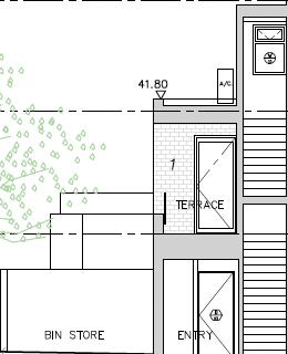

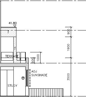
Building frontage Individual entries to ground floor dwellings and habitable room windows facing the street.
-Elevating the ground floor approximately 0.5 to 1 metre above the street level and/or providing landscaping in a front setback
-Entry facing Parker street
-Trees in front setback Y
Building articulation
-Building façades : appropriate rhythm and proportion respond to the building’s uses and context, and fine grain urban character
-Solid architectural expression : emphasises the street edge
-Side setbacks: break down building mass
Stepped built form with :
• Pitched roof
• Recessed balconies
• Framed elements
• Solid balustrades
Side setbacks :
• Permeable paving laid
• compacted toppings surface
• landscaping
Car parking and vehicle entry
Site services
Landscaping
-Vehicle access to the rear / side
-Car parking not seen from the public realm
-Pedestrian safety and sight lines
-Service infrastructure concealed / integrated into building design
-Waste storage areas screened from view of the street
-One tree in the front setback
-Tree planting along the side and rear setbacks
Clause 52.06 Car Parking :
Statutory control complies with no permit-triggered
Clause 52.34 – Bicycle Facilities
-Undercover car space located to the side in a secure well ventilated garage Y
-Service infrastructure concealed and integrated
-Waste storage at the rear Y
- 5no. new canopy trees
- Garden beds containing low to midsized native plants Y
Below the four-story limit requiring resident and visitor bicycle spaces but the space provisions and design are considered as appropriate.
Clause 53.18 – Stormwater Management in Urban Development
Stormwater management initiatives are included in the design response to Clause 15.02-1L.
Clause 55 (ResCode)
(Full assessment of ResCode is not covered in this assignment)
Clause 55. 02 NEIGHBOURHOOD CHARACTER AND INFRASTRUCTURE
Standard B1
Neighbourhood character
objectives
Objective
To ensure that the design respects the existing neighbourhood character or contributes to a preferred neighbourhood character.
To ensure that development responds to the features of the site and the surrounding area.
Requirement
The design response must be appropriate to the neighbourhood and the site.
The proposed design must respect the existing or preferred neighbourhood character and respond to the features of the site.
The subject site is located on the eastern side of Parker Street between Gaffney Street and Hayes Parade which is a growing residential area, undergoing substantial development on mid to low-rise housing. Its north is neighbourhood commercial areas serving daily needs and south and west are established residential zones
Its immediate interface can be described as follows:
• North: adjoins property 7 Parker Street is to be demolished and is currently in town planning for 3-storey development. Further north, adjoining property 5 Parker Street, is under construction on a 3- storey townhouse.
• South: adjoins the single-storey townhouse of Units 1 – 4, 11 Parker Street.
• East: Pascoe Vale Station Reserve (Craigieburn Line), abuts the site and is zoned Public Use Zone 4.
• West: faces No. 10 Parker Street across the road.
Immediate interface

The proposal meets both the objective and the standard B1 of 55.02-1, in response to the existing neighborhood character. The three-story townhouse is appropriate in the neighborhood area which surrounding buildings are predominantly lower-rise housing. The simple built form, building height and façades are consistent with respect to the surrounding building. Key building materials of bricks and Colourbond
provide a coherent visual with adjoining buildings with similar materials used. Adequate landscaping design and retaining existing street setbacks respect the neighborhood area.
The proposal is consistent with the relevant planning policies and provisions. The dwelling generally meets the design requirement, contributing a high-quality housing supply that responds to the neighborhood character.
Regarding setbacks (55.04-1- B17), the proposal generally meets the rescode objective in respecting the surroundings and limits the impact on the amenity of existing dwellings. However, rear setbacks on the 1st and 2nd Floor which are below the minimum requirement (6 meters), might not fully achieve the objective of Clause 55 (provides reasonable standards of amenity for new residents), particularly, the open space area on the terrace (1F) raise concern on visual (too close to the trees), noise, air quality (impacted by the abut railway).
A permit should be granted subject to increasing the respective rear setback.
Describe the relevant aspects of documentation supplied with the application (ie the consultants’ reports, particularly regarding planning matters) in terms of:
1. Do they interpret the planning scheme in a way that favours the applicant’s interests?
The submitted documents sought to interpret the planning scheme favouring the applicant’s interest. Policies and provisions are often generally written, the scheme provides room for various interpretations. Regarding the objectives of Clause 55.02-1 (Neighbourhood character), the design development should respect and contribute to a preferred neighbourhood character while responding to the site features and the surrounding area. This section is likely to be contextually driven, enabling a large scope of discretion (Rowley, 2017, p.221). The interpretation of the neighbourhood character can be subjective. Particularly, standard B1 states that the design response should be appropriate and respect the existing or preferred neighbourhood character. While the terms “appropriate” and “preferred” are seen to be arbitrary and arguable, the non-specific standard enables applicants to justify their application by focusing on aspects in which the proposed development design responds to the provision. For instance, the planning consultants’ report in this application claims the design response to the planning scheme through establishing “an appearance complimentary to the character of the area and distinctive work of contemporary architecture integrated with the evolving inner-urban design aesthetic”. However, it is subjective if the use of the proposed materials or built form is appropriate and preferred in response to the surrounding context, while other design aspects might alter how the new development responds to the neighbourhood charter and might be neglected.
The documents present how the proposal complies with the Rescode standard with biases. The operation of Clause 55 states that the standard should normally be met but if the application for an alternative design solution meets the objective, it may be considered. It implies that a permit can still be granted even though the requirements of the standard are not fully met if the design responds to the objective of the standard. Thus, the documents tend to interpret the standards as “deemed to comply” provisions (Rowley, 2017, p.216). In this application, the planning report claims that all setbacks comply with the building design provisions. In examining the development plan and standard B17, the side setback from the 1st-floor living room outlook is slightly below the required minimum distance while the rear setbacks on the 1st and 2nd floors meet only approximately 50%. The proposal does not fully comply with the quantitative standard but the planning report justifies it as “comply” based on the self-interpretation of the objective. Particularly, it claims the rear
setback is a reasonable outcome since “the adjoining landscaped railway reserve is not a residential zone with the platform not close to the building”. Although it generally meets standard B17, the justification neglects the negative amenity impacts of inadequate setbacks on the residents in the proposed building, like visual impact from the Tarence, overshadowing, noise and air pollution impact caused by the railway.
2. Explain your reasons/assessment in terms of achievement of overarching planning objectives.
In examining the submitted documents, they partly support the proposal in achieving the objectives.
One key overarching policy to facilitate a sustainable community in the PPF is consistently supported by the MSS. In Clause 02.02 (Vision), the plan seeks to create sustainable neighbourhoods with well-designed development addressing environmental management. ESD control, stormwater management, and landscaping requirements are incorporated into the requirement under zone, overlays, and particularly, Rescode standards to regulate the residential building design. Through examination, the building design and construction plan of the proposal addressed those issues achieving the sustainable design policy considerably. The SDA report examined the proposal scoring 65% for the BSEE report and on average 7 stars for the nationwide house energy rating scheme, proving that the design achieves the sustainable design objective with satisfactory ESD performance. It also achieves the objective of stormwater management facilitating on-site stormwater infiltration and maximizing the retention and reuse of stormwater while meeting the standard of the Redcode with a 20% permeable area of the site. Finally, the proposal design has adequate landscaping in setback areas while a tree protection zone is built to retain existing landscaping along the construction process. It achieves the overarching objective of creating a healthy and sustainable community through reducing environmental impact and providing green open space.
Increasing the diverse housing supply is another key overarching policy. The subject site is indicated as the neighbourhood center and plans to support significant housing growth (Clause 02.04). The neighbourhood center and housing policy are incorporated in the schedule of the zone and overlay to regulate the development built form. However, the submitted documents mainly focus on how the proposed dwelling complies with the relevant provisions and Rescode standards, with little justification on whether the development supports the objective of the neighbourhood center. The planning report claims the dwelling responds appropriately to the neighbourhood character since the surrounding buildings are predominating housing with similar build form and design. It is questionable if the single-use dwelling achieves the neighbourhood center objective of providing mixeduse development to support the daily community’s needs despite the proposal being consistent with the urban context. As justified by documents, the proposal satisfies most building requirements, particularly the height, but there is little justification if the development supports the objective of increasing housing density with an appropriate scale. In fact, this illustrates the contradicting and unclear objective of the
policy in the scheme. In residential zone to support significant housing growth, there are quantitative requirements for neighbourhood centers restricting the building height and coverage, contradicting the objective of providing dwellings with increased diversity and density.
Moreover, the standard emphasizes consistency with the surroundings but sets unclear directions to balance the objective of providing mixed uses to serve the daily and weekly shopping and service needs of the local community. It is arguable if “mixuse” should be achieved in each building or the area wholly with buildings on different uses. The “largely guidance-free” decision guidelines of the scheme provide room for applicants to support their application favouring their interests (Rowley, 2017, p. 107). Hence, the proposal shows limited evidence of achieving the overarching housing objective.
3. Discuss the implications of your findings for planning officers in local government as opposed to planners in private practice
When accessing a development proposal, planning officers in local government are required to interpret the planning scheme from multiple aspects while other planners, particularly in private practice, have strong and clear goals to prioritize provisions favoring the applications. The planning scheme contains overarching policies within the planning policy framework, local policy framework, statutory planning Controls in Zone and overlays and various particular provisions. The ResCode provisions include a long list of design objectives and standards but are considered intensive resource management (Powley, 2017, p.221). The findings above highlight the challenge and significance of expertise for planning officers when making assessments based on the scheme which contains contradictions and confusing directions among overarching policies. Planning officers have to balance both specific quantitative statutory requirements and visionary directions and objectives qualitative in nature. In the current planning system, VCAT appeal allows reviewing those shortcomings afresh. Regarding the balance between building height and density, the VCAT decision of Mellick v Stonnington CC [2018] VCAT 1495 provides useful insights on the wording of the GRZ parent clause on the storey restrictions, it clarified that if only a height limit in meters is specified in the schedule, there is no limit on stories. Despite VCAT as a separate authority that might provide a clearer interpretation of the planning scheme in assisting RA’s assessment, the process is time-consuming and relies on case-by-case justification. In this case, the limitation of density in terms of storey is better understood, however, it still lacks justification for density eg. In terms of bedroom size or numbers.
Moreover, the board scope of the planning scheme provides room for documents to be subjectively written as discussed above. Planners as consultants are likely to focus on selective provisions and standards favouring their applicant's needs and interpreting the objectives and standards with biases. Planners working for compliance tend to claim the proposal meets most standards. The submitted documents usually have potential biases that might alter planning officers when making assessments. As a result, the permit assessment process might fail to address some important concerns for development. For instance, planning provisions
encourage high-quality design housing well-designed with comprehensive amenities, yet these housing developments are usually supported by high prices and rates. Although the development meets the dwelling requirements in the application, there is little consideration for housing affordability. A recent planning scheme amendment VC187 examines the shortcomings of the existing assessment process. It introduces a new provision aiming to increase the supply of social and affordable housing in Victoria by streamlining the permit application process for housing projects by or on behalf of the Director of Housing. It assists in ensuring sufficient affordable housing provisions while shortening the long permit application process and reducing potential challenges for RA when doing the assessment based on the overarching planning scheme.
Finally, the planning scheme has an aspirational direction proving a sustainable community that accommodates future needs. Importantly, planning officers from council's perspective have to make assessments with a forward-looking view, while planners as consultants mainly focus on the interest of their clients under current business needs, for instance, saving building costs to increase profit. In fact, the planning scheme provisions lack specification on “the future needs”. Planners should often make assessments based on their subjective judgment of emerging needs. Planners that are less familiar with the area might have to rely on supporting documents with biases to understand the subject site while making judgments based on standards and requirements in the scheme. In this application, lower-rise townhouse positively responds to the current urban context, but higher-rise apartments might be more suitable if the area faces sudden population growth. Despite that community stakeholders can raise applications on the planning scheme amendment to incorporate provisions catering to the growing needs, the application is time-consuming and decisions often involve balancing the interests of different stakeholders, conflicting interests can lead to disagreements and delays in the decision-making process. Since assessments made by planner officers are bounded by the scheme, it might fail to regulate development that fully addresses the community needs efficiently.
(1646 words)
Rowley, S. (2017). The Victorian Planning System: Practice, Problems and Prospects. Federation Press.