

MEIDINE
LANDSCAPE ARCHITECT
« There are lots of little bits of space »
- George Perec, Espèces d'espaces


ADÈLE MEIDINE
LANDSCAPE ARCHITECT
+(33)6.81.97.92.82
ADELEMPAYSAGE@GMAIL.COM
TRAINING - DEGREES
09/2016 09/2019
3 years
09/2013 06/2016
3 years
ÉCOLE NATIONALE SUPÉRIEURE DU PAYSAGEENSP - Versailles
State Diploma in Landscape architecture
ÉCOLE DE COMMUNICATION & ARTS APPLIQUÉS -
COM'ART - Paris
BTS Design d’Espace

SENIOR LANDSCAPE ARCHITECTSNØHETTA - Paris
Main projects and references
Project management :
La Croisette réinvente sa légende : Renovation and enhancement of waterfront public spaces, in collaboration with Atelier d'Urbanité Roland Castro Phases AVP, PRO, DCE and construction site supervision
Tribunal administratif et Cour Nationale du Droit d'Asile de Montreuil Phases AVP, PRO, DCE and construction site supervision

TECHNICAL SKILLS
cad - Autocad
adobe - Illustrator, Photoshop, Indesign, Lightroom
geographic information system - Qgis
3D - Sketchup, Lumion, Vray
video editing - Lumion, After effects, Premiere
LANGUAGES - Fluent written and spoken English
PHOTOGRAPHY - Film and digital, Fujifilmx
05/2022 03/2023
SENIOR LANDSCAPE ARCHITECTD'ICI LÀ - Paris
AMITER - "Mieux aménager les territoires en mutation exposés aux risques naturels" à Monterault-Fault-Yonne, in collaboration with LOCAL.EU and Urban Water
JUNIOR LANDSCAPE ARCHITECT MUTABILIS Paysage et urbanismeParis
Main projects and references
Competitions
Redeveloping the banks of the Seine, Ris Orangis
Project management : Bordeaux Lac «40 Journaux» Design and layout of a new neighborhood: - Planting plan and plant strategy for all communal spaces, technical details booklet, DPGF, CCTP Phase PRO
JUNIOR LANDSCAPE ARCHITECT
COBE Architecture Paysage et urbanisme - Paris
Main projects and references
Competitions :
ZAC les Châlets in Toulouse
Creation of a therapeutic and sound garden
Project management : Cité Descartes à Champs-Sur-Marne. Phase PRO - Technical details, furniture and plantings

04/2021 05/2022
13 months


Main projects and references
Urban studies
Paléficat, Rives de l'Hers
Creation of an eco-district - housing, public facilities and retail in collaboration with MGAU, Les Marneurs, MAGEO, RR&A et Solenvie
LANDSCAPE ARCHITECT - Hugo Bruley Landscape Architecture - Paris
Main projects and references
Competitons : ZAC du Clos du Bourg à Olivet, in colaboration with Lambert Lénack, Clément Blanchet and SATHY
09/2020 04/2021
8 months

JUNIOR LANDSCAPE ARCHITECT FLORENCE MERCIER Paysagiste
Main projects and references
Competiotns
Parc Jacques Chirac Nîmes, France
Conversion of the former nurseries Pichon
Development and creation of a play and leisure area
Saint-Nicolas-de-Port, France
Project management : Design and development of the South sector of Pierrefitte-Sur-Seine : Phase PRO - Construction site supervision

LANDSCAPE ARCHITECT INTERN
SWA Group - San Francisco - USA
Workshop:
Resilient by design - Save aquatic pier : Ideas competition on the future of the San Francisco Bay Area and climate adaptation
LANDSCAPE ARCHITECT INTERN
SWA Group - Los Angeles - USA
Competition
Designing the Horton Square in San Diego
Project management : Conception and development of the hotel gardens Hyatt-Dream Hotel in Palm Springs
03/2018
7 months Since 03/2023 18 months On going 09/2020 04/2021 8 months 04/2018 10/2018 6 months 09/2020 04/2021 8 months
ECOLOGICAL NOVEL AWARDREVUE ESPRIT - LA FABRIQUE ÉCOLOGIQUE
Jury member and publication in Les carnets du Paysage : Sous l’horizon
COMPETITION LAND ART GENERATOR INITATIVEENSP - CENTRALE SUPÉLEC Jury prize-winning project - Michel Desvigne
SAN FRANCISCO BAYWATCHSWA SUMMER INTERNISHIP PROGRAM
Publication : Urbanism, Infrastructure & Ecology at San Francisco’s Northern Waterfront
CLAIRE TRAPENARDLandscape architect and associate of D'ici-là ct@d-ici-la.com
EMMANUELLE VALERSTEINASArchitect and project leader at Snøhetta Paris emmanuelle@snohetta.com
BRUNO TANANTLandscape teacher & director of the department Projet- Ecole nationale Supérieure du Paysage b.tanant@tnplus.fr
SMALL SCALE
LA CROISETTE REINVENTS ITS
LEGEND
location - Cannes, France
timeline - 2023 - 2028
studio - Snøhetta
type - Public contracting
project ownership - Ville de Cannes
team - L’Atelier d’urbanité Roland Castro (mandataire), Snøhetta, WSP, L’Observatoire International, JML
surface - 2,6 km
subject«Spotlight»
Famous the world over for the International Film Festival it hosts every May, this 2.6 km-long promenade runs from the Palais des Festivals along the Bay of Cannes to the Cap de la Croisette.
The current design dates from the 1960s, but the origins of the Croisette date back to the late 1800s, when Lord Brougham discovered the beauty of the Bay of Cannes and subsequently settled here.
Over time, the Croisette has undergone considerable transformation, from the picturesque coastal road it was to the bustling boulevard it is today. It is punctuated by palaces, luxury stores and listed buildings on the city side, and a variety of beaches on the sea side, from public beaches to the most exclusive beaches connected to the palaces.
The proposal will support Cannes' ambition to restore the Croisette to the status it deserves, bringing its prestige and beauty up to the standards expected for such an exquisite and iconic waterfront.
An open public space
Inspired by Art Deco, referring to the palaces of Cannes, Snøhetta aims to build respectfully on the Croisette's great success, reorganizing the boulevard, making it greener, more open and accessible, as well as providing new amenities and comfort.
Following the perfect circular shape of the Croisette, the proposal emphasizes the regular repetition of staircases leading to the beaches and overlooking the Mediterranean Sea, creating a seductive and emotional rhythm.
©ImagecreditSnøhetta


STONE LAYOUT & RESEARCH STUDIES TECHNIQUES CAD RHINO


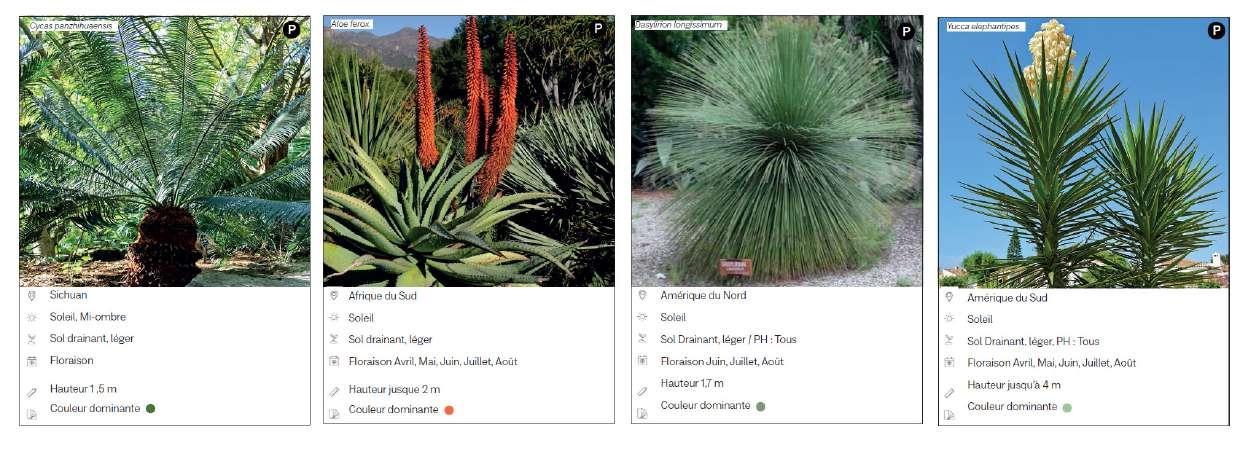
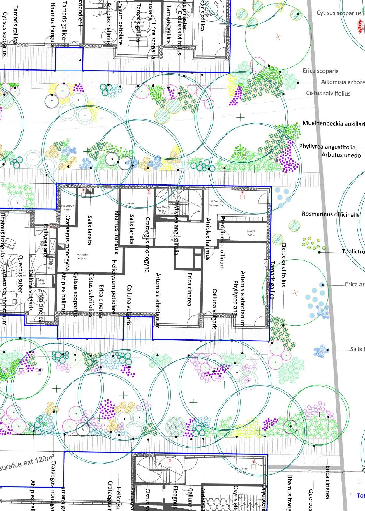
DIAMONDS - PLANTATION PLAN
COASTLINE GARDENS - ATMOSPHERES
COASTLINE GARDENS - PLANTATION PLAN


COUR NATIONALE DU DROIT
D'ASILE
location - Montreuil, France
timeline- 2022 - 2025
type - Snøhetta
type - Corporate contract
project ownership- APIJ
team - Eiffage construction, Otéis, AMOES
surface - 22,162m²
subject-
“Relocating two jurisdictions around a green heart”. How can architecture and landscape help to support asylum seekers facing a change of life? In collaboration with Eiffage Construction and the design offices OTEIS and AMOES, Snøhetta was chosen to design the relocation of the Cour nationale du droit d'asile and the tribunal administratif de Montreuil.
The Cour nationale du droit d'asile (CNDA) is the only court of its kind in France to hear appeals against decisions by the French Office for the Protection of Refugees and Stateless Persons (OFPRA). Every year, it welcomes several thousand people of over 160 nationalities. The Court is therefore the court of last resort for deciding the future of asylum seekers in France, handling disputes relating to residence permits, refusals and injunctions to leave the country.
This project will relocate the Cour nationale du droit d'asile, currently spread over several buildings in Montreuil, and the tribunal administratif within the same perimeter. Bringing the two jurisdictions together will enable them to share spaces, gardens and services, creating more welcoming and safer conditions for visitors and for the 940 employees working in both jurisdictions.
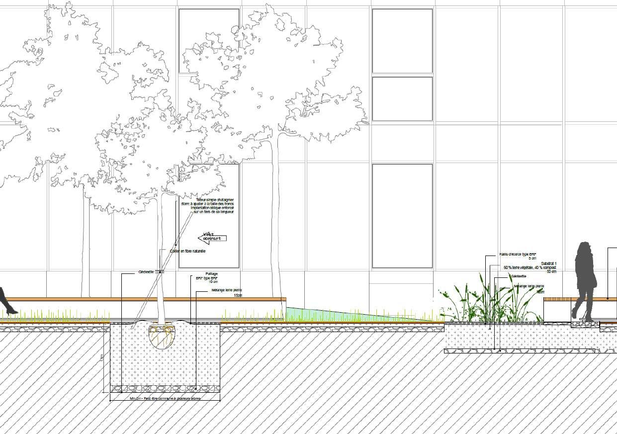
The messages of transparency and security are conveyed by the sober architecture, which blends into a more residential area, and by the openness of the reception and waiting areas. As an extension to these shared spaces, a generously planted 700 m2 garden will be accessible to visitors, offering tranquillity and promoting biodiversity.


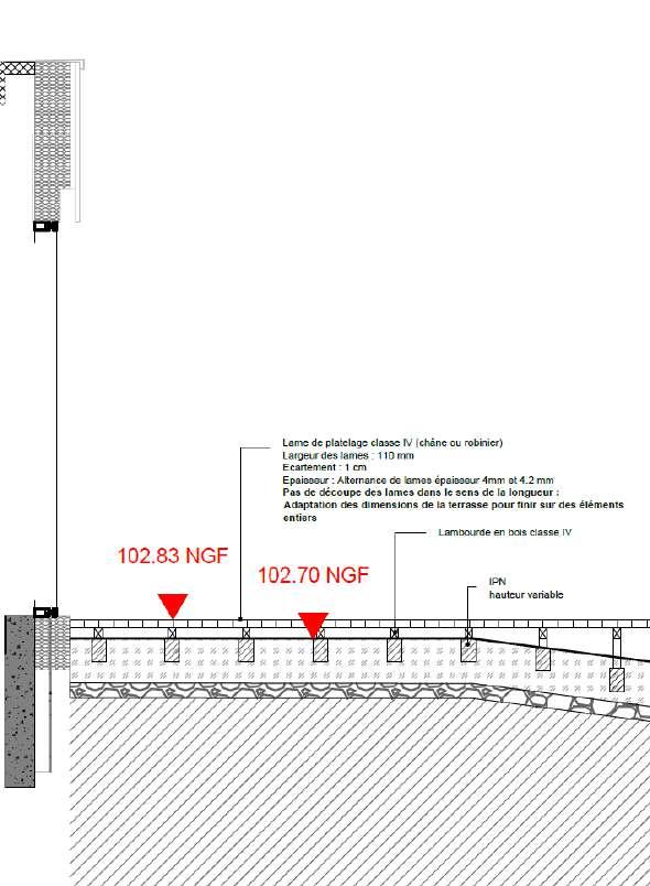


CONSTRUCTION DETAILS - BANISTER STAIRCASE FORECOURT


LE JARDIN DES REQUÉRANTS PLAN DE PLANTATION

localisation - Montpellier, France
date - Juin 2023
agence - Snøhetta
type - Concours
maitrise d’ouvrage - MTPCA, Montpellier Métropole
maitrise d’oeuvre - Snøhetta (mandataire), UVA
surface - 25 000 m² de surface bâti
sujet -
«La Folie Puech»
Implantée sur la place Françoise Héritier, à proximité de la Halle de l'innovation, cette "folie" architecturale s'étendra sur 25 000 m² de bâti. Plus qu'un simple siège avec des bureaux, c'est un campus ouvert sur le quartier que la Caisse régionale entend développer.
Fidèle aux valeurs de proximité, de responsabilité et d’engagement du Groupe Crédit Agricole, le projet paysager, prend ses racines dans l'histoire et la vie du territoire, avec une proposition qui évoque les Folies, ces demeures du 18e siècle à la créativité architecturale inédite pour l’époque.
En s'inspirant des paysages naturels et agricoles de la région, un paysage productif s'installe à tous les étages. La culture traditionnelle de la vigne est célébré, permettant d'offrir aux travailleurs, visiteurs et acteurs locaux de cultiver et consommer la vigne dans un cercle virtueux.
Le nouveau siège du Crédit Agricole du Languedoc incarne les valeurs environnementales et sociales de l'entreprise. Doté d'espaces de travail innovants, il favorisera les interactions et le bien-être des utilisateurs tout en limitant son impact sur l'environnement.
La conception du bâtiment intègre des techniques de construction durables, permettant de réduire son empreinte carbone. Des espaces verts et des aménagements paysagers contribueront à créer une atmosphère de tranquillité et de fraîcheur, offrant aux occupants un havre de paix en plein cœur de la ville.


LeterritoiredeMontpellier

Laceintureagricoledeproximité


Lerayonnementdusavoir-fairelocal
SCHÉMA D'INSERTION TERRITOIRALE
VINEYARD CIRCULAR ECONOMY IMAGE CONCEPT
©CréditimageSnøhetta

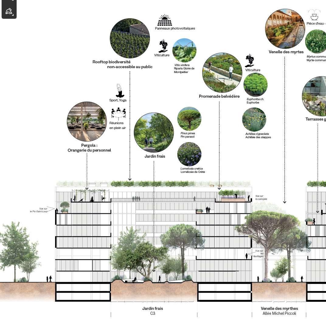
INTEGRATING THE MEDITTERRANEAN LANDSCAPE INTO VERTICALITY
LONGITUDINAL SECTION
TECHNIQUE AUTOCAD PHOTOSHOP

Dalle
SAN FRANCISCO BAYWATCH
location- San Francisco, USA
date - Juin 2018
teachers - Elizabeth Shreeve, Yu-Chung Li Ying Yu
subject - Summer internship program

THAT SHAPED AQUATIC PARK, THEN GENERATED
Aquatic Park lies at the confluence of three dynamics: human, earth and water.
On the scale of the urban district, I was interested in how these dynamic influences come together within this generous open space.
-Human: The flow of people, experiencing the site mainly from East to West, with the Golden Gate Bridge as their final destination. San Francisco is currently considered the third worst city in the USA in terms of traffic. The waterfront is a highly congested area.
-Terre: Over time, SanFrancisco's street network has gradually expanded, filling in the bay. was inspired by the process of revealing hidden streets, with a poetic homage to San Francisco's history.
Water: Today, as sea levels rise, we're faced with the opposite situation: our built-up roads will be flooded by the waters of the bay.
The configuration and environment of San Francisco’s waterfront have changed through both natural processes and human development. Historically, the Bay Area represents a natural paradise with abundant and varied habitats for marine species; however, 80% of natural marshlands have been destroyed by human activity including hydraulic mining, ground water utilization, marine infrastructures, and levee construction, vastly reducing the mudflats and marshland that provide natural cushions between the sea and the land. Sea level rise exacerbates the impacts of these losses, opening up potential for flooding and wave impacts on shorelines areas. An analysis of historical geography reveals the earlier shoreline and how much of the north and east waterfront, including most areas under Port jurisdiction, sits atop landfill.
How can Aquatic Park adapt to future flooding while preserving the character of an urban beach?

GOLDEN GATE BRIDGE SITE
BAY BRIDGE
PACIFIC OCEAN


PEOPLE’S FLOW/HIDEN STREETS URBAN ANALYSIS


The water reflects the blue of the sky, but seen from above, its color is mainly based on the green of seaweed - phytoplankton - and the brown of
THE COLOR OF WATER INSTALLATION AND ARTISTIC RESEARCH
THE PART OF SHADOW
location - Île de la Cité, Paris
timeline - March - May 2017
teacher - Nicolas Gilsoul
subject - A parc in the city

ACCLIMATATION DIAGRAMS
TECHNIQUE SKETCHUP
JARDINS DE COLLECTION
AMPHITHÉÂTRE JARDIN
AMPHITHÉÂTRE JARDIN
LA SAINTE CHAPELLE
COLLAGE CONCEPT Bringing the island to life

COLLAGE CONCEPT Paris under paris
JARDIN D’OMBRE
PRÉFECTURE DE POLICE

PELOUSE ÉVÈNEMENTIELLE

CITÉ
MÉTRO
QUAI CITOYEN
THE SPIRIT OF THE DOMESTICATED LAKE
location- Bordeaux, France
timeline - 2021
studio - MUTABILIS PAYSAGE & URBANISME
type - Plantations et planting strategies
project ownership - COVIVIO
team - MUTABILIS, BLP, Verdi
surface - 3,6 hectares
subject -
“Inhabiting the lake
Following in the footsteps of the new residential districts on the shores of Bordeaux lake, the “40 journaux” district project is guided by an approach to the wider landscape and the spirit of the place, to create a strong project with identity and respect for the site in which it is set.
Within the plot, the retreat of the lakefront building line gives way to a natural plant structure whose vocabulary is typical of the lake (pine forest, dune garden, pine needles, sand, etc.) and gives a sense of the great landscape, but also makes it possible to reduce the presence of infrastructures, in particular Avenue Marcel Dassault, which accommodates the tramway.
This strong, emblematic plant structure creates a range of landscapes, perspectives and uses within the future district, offering a wide diversity of uses and living styles.
Rooftops, too, have been taken over, offering a wide range of uses and opportunities to enhance biodiversity, with rooftop vegetable gardens, communal terraces and solariums, as well as green roofs and “wilder” gardens (stinging nettle gardens, thorn gardens, etc.) where beehives, for example, could be installed.


TECHNIQUE ESQUISSE image référence

SIMULATION D’ENSOLEILLEMENT
TECHNIQUE SKETCHUP
PALETTE ET FEUILLAGE D’OMBRE

NANCY COURTYARD
location- Nancy, France
timeline - 2022
studio - HBLA
type - Housing
project ownership - SAS Nancy Coeur d’ilôt
team - HBLA, LOCAL EU
surface - 3750 m²
subject -
The landscape project proposes the installation of a significant tree layer over a large part of the project's open spaces, as an extension of the existing nearby Classified Wooded Area (EBC).
The inhabited undergrowth is characterized by more or less dense plant matter, alternating between full and empty spaces, closed, densely planted areas with a shady plant atmosphere, and grassy clearings opening onto the wider landscape and the center of Nancy. Some areas invite pause and contemplation, while others are ideal for informal gatherings and activities.
The paths are designed to resemble forest trails. Formed in hollows, they disappear from perspective and from view, contributing to the almost childlike sensation of exploring unknown territory. They have a reduced footprint, freeing up the land for generous, open-ground plant surfaces. Access ramps and forest-like staircases are used to overcome unevenness.
INHABITED UNDERGROWTH MASTERPLAN


ALTERNATING FULL AND EMPTY SPACES CROSS SECTIONS
TECHNIQUE AUTOCAD


DREAM HOTEL
location - PalmSprings, USA
timeline - 2018
studio - SWA group - Los Angeles
type - Hotêl, private luxury garden
project ownership - Selene International
team - Hirsch Bender Associates, SWA
surface - 6 317 m²
subject -
Raw yet refined, sustainable yet sophisticated, Dream Hotel must offer its guests and community an experience that engages with its context and celebrates its environment.
The project proposes an interpretation of the Californian desert, through a typology of domesticated landscapes. From the giant boulders of Joshua Tree to the cultivated fields of orange trees, the highly contrasting tones, textures and smells are crafted according to the rhythm of the desert's seasons.
The overall composition, both wild and formal, evokes the ever-renewing musicality of the desert.
THE FOUR SEASONS OF THE DESERT (AUTUMN, SUMMER) IMAGES CONCEPT
SKETCHUP LUMION


BLOOMING CALENDAR
TECHNIQUE INDESIGN


THE FOUR SEASONS OF THE DESERT,CABINET DE CURIOSITÉ) IMAGES CONCEPT
TECHNIQUE SKETCHUP LUMION

LARGE SCALE
IN REVERSE
The North-West American retreat
location- California, USA
timeline - February - July 2019
teachers - Bruno Tanant, Alexis Feix, Esther Salmona
subject - Final year project, ENSP Versailles
California stretches 1,300 km from north to south. Its landscapes are both immense and contrasting. From a foggy, mountainous coast bordering the Pacific Ocean, to the snow-capped Sierra Mountains in the West and the scorching deserts, it's the immensity of its landscapes and its hydrological amplitude that make it one of the richest regions in terms of biodiversity.
It's a land of fascination, with coastal cities on one side, and wilderness on the other.
Today, water policy and land appropriation mean that the region is subject to multiple risks. On the one hand, rising sea levels and coastal erosion, and on the other, collision with natural habitats, mean that we no longer know where to go or how to accommodate future migrations, be they human, animal or plant.
How can we increase population while increasing biodiversity and preserving water resources?
This project aims to find a new direction for urban expansion, a new model for land appropriation.
By identifying strategic points as emblematic project zones that will be priority levels for transformation between now and 2030, a master plan for 2100 is taking shape on a different scale across the continent.
To face the world to come, we need a strategy that goes beyond the political and cultural scales of land appropriation. If the archetypal coastal city is no longer reliable, then there is no model, and therefore no precedent.
We need to invent other forms, based on rules that recognize the interdependence between different scales of ecosystems, rather than the unilateral links between large cities.

Existing trails
New connections
Biodiversity hotspots
Protected areas by IUCN category 1-4 (wilderness areas, national parks, natural monuments)
Protected areas by IUCN category 5-6 (protected landscapes/seascapes, protected resource management areas)
INTERCONTINENTAL PARK
2 CONTINENTS
13 COUNTRIES
25 000 KM
2 YEARS WALKING
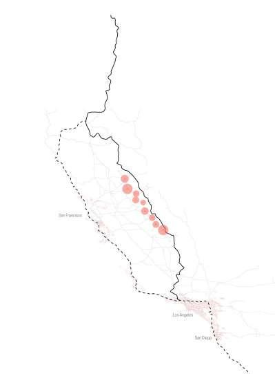


Reconnecting the new megalopolis with nature
CALIFORNIA FLORISTIC PROVINCEHORIZON 2100
Step 1: Retreat of coastal towns towards the Sierra Nevada foothills
Step 2: Reversing the wilderness by the expansion of the sequoia belt corridor
Step 3 : Freeing the San Joaquin River and connecting to the Pacific Trail
THE NEW FLORAL PROVINCE OF CALIFORNIA MASTERPLAN


Klamath Mountains / Siskiyou Forests
Feu
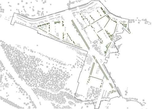
MONTEREAU BUSINESS PARK
location - Monterau-Fault-Yonne, France
timeline - 2021
studio - HBLA
type - Masterplan, competition
project ownership - AMITER, Ville de Montereau
team - HBLA, LOCAL EU, Urban Water
surface - 175 hectares
subject -
Situated at the confluence of the Seine and Yonne rivers and their respective valleys, the site faces challenges in terms of both vulnerability to flooding and loss of attractiveness.
The project proposes the use of landscape as a tool for sustainable transformation of the Business Park. Through a series of incremental public and private actions, a landscape matrix is gradually taking shape, with the aim of inverting the current figure into a tree-lined archipelago, where large productive islands would be linked by a continuous, omnipresent landscape material adapted to the singularities of each situation.
Comprising streets, parks and promenades, linear basins, wastelands, tree canopies and pathways, this matrix is being gradually and opportunistically installed as operations progress.


LANDSCAPE INTEGRATION ANALYSIS DIAGRAMS
TECHNIQUE SIG PHOTOSHOP/ ILLUSTRATOR

REPRESENTATION OF LANDSCAPE GRID AERIAL VIEW AND PERSPECTIVE
TECHNIQUE SKETCHUP PHOTOSHOP

Insertion
Aléas et risques naturels à grande échelle
PAU DEHOUSSE DISTRICT

location- Pau, France
timeline - 2022
studio - HBLA
type - Masterplan
Project ownership - Ville de Pau
team - HBLA, Studio Chams Arouise
surface - 24 hectares
subject -
Pau is a town in southwestern France. With its privileged geographical location, it lies at the interface between plain and mountain, 25 km from the foothills of the Pyrenees. Alphonse de Lamartine wrote of this unique panorama: “Pau is the most beautiful view from the land, just as Naples is the most beautiful view from the sea”. The city is also at the crossroads of the Gave valley and the trans-Pyrenean routes. In the 12th century, the lords of Béarn built a châté to watch over a strategic ford on the Gave, before becoming the seat of the sovereigns of Navarre. Today, Pau retains its character as a promontory city, albeit with a dense urban and economic fabric.
The site of the new Dehousse district lies to the south of the Gave, and is currently occupied in part by factories, most of which have fallen into disrepair. The project proposes the creation of a landscape matrix around a central axis, in order to remove a large part of the water from the soil and revitalize the southern part of the town, which is currently landlocked. Various landscape components (riparian forests, meadows, garden squares) will gradually create a canopy of trees, reconnecting the entire district to the historic heart of Pau, as well as to the wider region..

THE SITE AT THE CROSSROADS OF MAJOR LANDSCAPE FEATURES
TECHNIQUE GOOGLE EARTH PHOTOSHOP

GENERAL AND HYPOTHETICAL VISION OF THE PROJECT MASTERPLAN
TECHNIQUE AUTOCAD PHOTOSHOP


THE MAIN AXIS
URBAN SQUARES
THE BIG GREEN CARPET
TREE CANOPY


ALFORTVILLE GARDENS
location - Alfortville, France
timeline - 2020
studio - CoBe
type - Framework agreement for urban project management
client ownership- Ville d’Alfortville
subject - The Jardins d'Alfortville site is part of a rapidly changing system. The arrival of the major transport hubs of the Grand Paris and urban densification projects is bringing new flows and uses into the existing urban fabric.
The first step is to identify the site as an urban archipelago: at the center of a green corridor (the Vert-DeMaison, Port-à-l'anglais and railway wasteland parks) and a blue corridor (the Seine), both rich in biodiversity, today encircled by major infrastructures and an enclosed urban environment.
This is a major challenge for us. The aim is to seize the opportunity presented by the site's transformation to reconnect the Jardins d'Alfortville with larger-scale landscape and urban systems.


SLOWNESS OBSERVATORY

location - Grenoble, France
timeline- March 2018 - June 2018
teachers - Bruno Tanant, Alexis Feix
subject - Atelier 7, ENSP Versailles
If the speed of progress and the influence of the Grenoble metropolis have clashed with the speed of nature, the Sanatorium today marks this temporal break, where the risks of flooding and landslides have led to its abandonment.
How do we strike a balance between technical progress and natural genius?
The creation of a botanical trail, from the southern tip of the point to the rocky slopes, would not only raise public awareness, but also encourage research and innovation in the face of the challenges of climate change in the mountains. By bringing together the key players in Grenoble's climate research (CNRS, Natural History Museum, Grenoble Alpes University, etc.), the Sanatorium site would become a climate research laboratory, where applied sciences and natural engineering would find a balanced relationship. On the basis of the former Sanatorium, an in-depth study should be carried out on the slope break and its effects on the landscape and climate.
By reworking the excavation at the bottom of the slope, the creation of a retention basin would limit the effects of flooding from the mountain to the watercourses, developing bog vegetation.
By interlocking scales, the microtopography found there would give rise to a micro-climate, causing the upper floors to cool, thus calling on the engineering of floristic players such as the hook pine and its evapotranspiration effects, or the potentilla to combat erosion.
Considering the actions of man and plants as an interdependent system, the fight against risk would become a commonplace of conservation, that of slowness.
“There is a secret link between slowness and memory, speed and forgetting.”
- Milan Kundera


BIOREGIONAL STRATA
POSTER FOR THE MUSÉEUM D'HISTOIRES NATURELLES
TECHNIQUE PHOTOGRAPHY COLLAGE

Pinàcrochet
DentdeCrolle
SaintHilaireduTouvet
Potentille
VulnairedesAlpes
LisdeSaintBruno
Rhododendron
Prèle
PALÉFICATRIVES DE L’HERS
location - Toulouse, France
timeline - 2021-2022
studio - D'ici-là
type - Masterplan
project ownership - OPPIDea
team- D’ICI LA paysagiste concepteur, MGAU (mandataire), Les Marneurs, MA-GEO, RR&A SOlenv e
surface - 121 ha
subject -
The “Paléficat-Rives de l'Hers” site represents one of Toulouse's last land reserves, defined to the south by the Autoroute des Deux Mers and to the north by the Hers river. It is also a site that links an urban area undergoing typological change with Toulouse's great agricultural plain, which today represents a major challenge in the transition of farming models, the response to the Metropolis' food autonomy and the return of short cycles.
The site also represents a major challenge in terms of preserving ecological continuity. This exceptional site will carry the future district's existence through a strong positioning around the question of landscape. Our positioning is based on the living world, with human beings at the forefront in their relationship with the environment.

URBAN & CULTIVATED PARK
TECHNIQUE AUTOCAD ILLUSTRATOR
We're looking to make the most of the inputs (soil, planting) to create a genuine landscape infrastructure. MAP OF USES

PHOTO GRAPHY
I wondered when the phenomenon starts.
How long it lasts -
How long it takes to arrive.
I tracked down clues in the city, in the interstices, on the outskirts. But also those much further away to find the point of origin of the phenomenon Until it breaks.
I photographed, filmed and wrote about them. I listened to people in the street, followed bodies, observed the cycles of nature.
From early summer 2018 to late winter 2019, two journeys to track down the presence of time, and better reveal it.
I've turned my notes into a manuscript.
Only, to speak of these rhythms, I've classified them by units of time, not place.
Too often, we try to describe a landscape by distancing ourselves from its temporality - San Francisco, California, is not the territory of the instant, as we think, but of movement.
Phenomena, living or otherwise, are as much those of everyday life as those of nature. They move through the landscape, sometimes in flight, sometimes motionless. They move at their own pace.

Big Sur
A tide is a vertical movement of water created by the interaction of the Earth, Sun and Moon. The difference between high and low tide in a cycle is called the tide range.
There are two tides every 24 hours.

“If rain falls, the oxygen isotopes that get incorporated into the cellulose of the rings are different from the oxygen isotopes in the fog,” she explains.
“So I'm able to tell you whether this tree grew mainly on water from winter rains, or summer fog. So I can predict for each ring, whether it was a rather warm year, or a rather cold one.”
Winter rain, summer fog, carbon cycle, oceanic cycle, oxygen cycle... The rhythm of plants oscillates along the bay through time.
16.06.18, Exploratorium, Pier 15 10h15
Giant's route
25.02.19, Berkeley Botanical Garden Interview with Emily Burns, biologist, Native Plant Society, UC Berkeley

Sunset district
02.03.19, 10:15
Recology Center
It takes between 6 and 8 weeks to transform compost into organic matter.


27.02.19, Coloma
Interview with Dillon Brook, Scott Vail and Garett Gust, American River Conservancy
“San Francisco's main source of drinking water is the Sacramento River, which has its source in the Sierra Nevada peaks, from which flow numerous tributaries (McCloud river, Yuba river, American river...) It's 240km of water that links the Sacramento river to San francisco. In theory, the quantity of water transported depends intimately on the seasonal cycles of rainfall, drought and snowmelt from the Sierra Nevada. Yet it takes just 83 hours for water to flow from a reservoir in Sacramento to a tap in San Francisco.
83h, for 240km, i.e. a speed of 2.49 km per hour

Fillmore & Sansome 2018
Bay area, from Berkeley’s hills 2019

Between April 2 and 22, 1951, Jack Kerouac wrote in one go the original scroll of On the road, published only 50 years later, in 2007. In this first version, the spontaneity of the vocabulary recalls the syncopated improvisations of jazz.
Landscape architect and graduate of the Ecole Nationale Supérieure du Paysage of Versailles, and originally from Chantilly, I grew up surrounded by wooded hillsides yet close to the city.
Early on, I discovered a personal affinity for the landscapes of satellite images, and the interfaces between sky and earth.
In an ever-changing world, I aspire to an optimistic vision. While two-thirds of the world's population will be urban by 2050, I attach great importance to improving the quality of life of living species, both plant and animal.
My design process is both thoughtful and inspired. My vision is that of an integrated, global system, measurable on the scale of a plant.
In this way, I believe that as designers, we have the ability to see and convey all the scales of the world around us through the eyes of a poet.
Spring at school, view from my window Versailles, 2019