
ECUADOR VOLCANOES
5,790M/18,996FT • 5,897M/19,347FT • 6,310M/20,702FT


5,790M/18,996FT • 5,897M/19,347FT • 6,310M/20,702FT
Dates: Departures throughout the year, see page 8 for details
Duration: 15 days
Departure: Quito, Ecuador
Price: US$5,040 per person
Ecuador is one of Latin America’s greatest secrets with its lush jungles, amazing beaches and at its heart, the high and wild Andes mountains. This trip incorporates Ecuador’s three highest peaks, Chimborazo 6,310m/20,702ft, Cotopaxi 5,897m/19,347ft and Cayambe 5,790m/18,996ft, and is ideal for people wishing to experience an exotic culture, amazing scenery and fantastic climbing all in one trip.
In the late 1800s, as English mountaineer Edward Whymper and his associates made their annual forays into the high country, they had no idea that they were stepping into mountaineering history as some of the first climbers to find alpine terrain directly on the equator at over 5,900m/19,000ft.
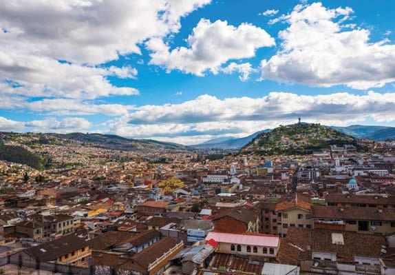
The Andes of Ecuador run as two parallel and impressive chains of peaks, rising dramatically from the Pacific Coastal Lowlands on the west and even more abruptly from the Amazon Basin on the east. Our flight into Ecuador gives us a grand view of the entire range
as we cross the country’s north-west coastline and pass just over the Pichincha Volcano (4,784m/15,696ft) standing right above Quito. It is an exciting entrance into a spectacular country and beautiful city.
The program begins with climbing team members meeting our guides for an initial program orientation. The following morning, after an early gear check, we head out on the first of three acclimatisation hikes to Ilaló Volcano (2,572m/8,438ft).
Ilaló is an inactive volcano located between the San Pedro River to the west and Chiche River to the east. It is located eight kilometers east of Quito, rising from a fertile green valley that enjoys a very mild climate and temperatures. Ilaló splits this valley in two; Valle de Los Chillos to the south and Valle de Tumbaco to the north. There is a small lava dome to the south called Milivaro
which is extinct as well. This entire volcanic complex has been covered in its totality by cangahua which is a fertile ash deposited by the wind from other, younger volcanoes in the region. The hike to Ilalo is a pleasant three to four hour hike, and from the summit there are great views of the surrounding peaks including Pasochoa, Pichincha, Cotopaxi, and Cayambe.
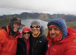
Our next acclimatisation hike is on Cerro Pasochoa (4,200m/13,780ft), an extinct volcano about 32km/20 miles south of Quito. Its large eroded crater opens to the west and its north-west flanks support a forest, like those that once covered the entire Quito basin. We establish a very easy pace on this day hike as we begin to get our bodies used to altitudes above 3,000m/10,000ft. The second of our acclimatisation hikes is on Rucu Pichincha and although its summit rises to 4,784m/15,696ft, our time in Quito and on Pasochoa makes this a good next step for us at altitude. Our primary goal on both of these days is to give our bodies a chance to begin their further adjustment to the altitude, while we enjoy some beautiful hiking and photographic opportunities. These rocky ridges, high grasslands and summits provide great views of the entire cordillera and an excellent orientation to Ecuador’s geography.
Cayambe is Ecuador’s third highest peak. Situated 65km/40 miles north-east of Quito, it stands at 5,790m/18,996ft looking out over Reventador, also known as “The Exploder”; one of South America’s most consistently active volcanoes. Cayambe’s glaciers are large and among the most active of all equatorial ice flows, so the varied glacial terrain here provides an excellent training ground and a rewarding summit climb.
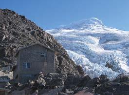
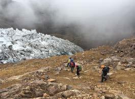
Having spent at least 72 hours above 2,700m/9,000ft, group members should be well acclimatised to begin sleeping and climbing at greater altitudes. Driving north, we pass through high rolling grasslands with wildflowers and occasional herds of sheep and llamas. Leaving paved roads, the track we follow passes several working haciendas, before steadily narrowing and becoming more rugged as it climbs higher and higher. Finally we reach a point within a half-hour hike of the large stone Cayambe Refuge (4,648m/15,249ft). This area serves as our base on the slopes of Cayambe and provides excellent views of the Glacier Hermoso.
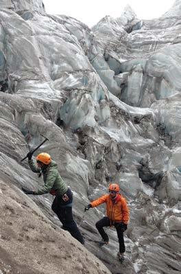
As we continue our adjustment to the altitude, we spend our first afternoon and the following day in moderate activity on a low section of the glacier. We work on glacier travel skills, techniques for protective
systems and the general procedures we will use in our ascents. The route we will take is not technical, but the number and size of the crevasses make the route serious and the route finding and overall climbing very interesting.
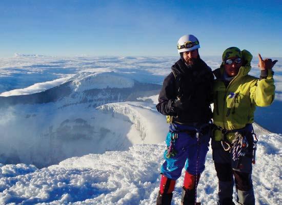
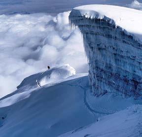
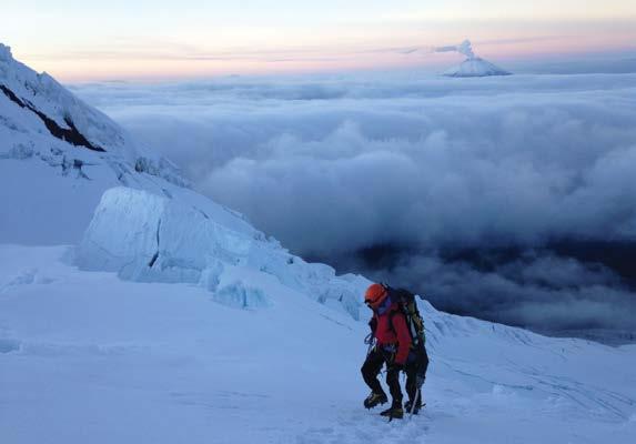
Climbing with headlamps, we leave long before dawn in order to have firm snow conditions throughout the ascent. For the first four hours, we make an easy glacier climb to a saddle and then continue onto steeper and more exciting ground. We traverse around large crevasses, many with enormous tropical icicles hanging from their edges. We pass some spectacular seracs and climb 35-degree slopes with occasional short steeper sections as we work our way to the crater rim. The final climb to the summit follows a photogenic line along the glaciated edge of the volcano’s crater, a fittingly dramatic ending to an ascent that is varied and scenic throughout.
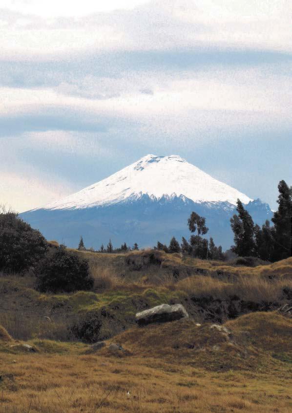
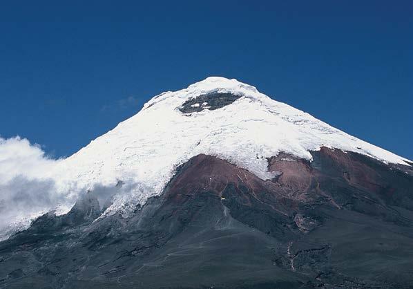
Situated in Ecuador’s eastern cordillera, Cotopaxi is the world’s highest active volcano. It towers high above a small altiplano (a high tableland) along with three other major peaks in the beautiful Cotopaxi National Park (Ruminahui 4,755m/15,602ft, Sincholagua 4,986m/16,360ft and Quilindana 4,917m/16,134ft).
Before entering the park, we drive south from Cayambe and stop for a night of rest at a 17th century hacienda from where we enjoy great views of Illiniza Sur (5,263m/17,268ft), Illiniza Norte (5,139m/16,861ft) and Cotopaxi.
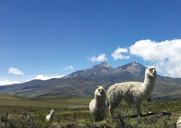
The following morning, we leave the fertile and richly green central valley and drive further east into Cotopaxi National Park. We travel through pine forests, then through drier and more open country as we ascend a rugged escarpment and finally reach a small altiplano beneath the park’s towering summits. As we make our way up and across the plain, we are fairly likely to get good sightings of wild horses, llamas and condors. Following a rather remarkable track in our vehicle, we are able to drive to around 4,600m/15,100ft and from there, a 45-minute climb with full packs takes us to the José Ribas Hut on Cotopaxi’s flank at 4,794m/15,729ft.
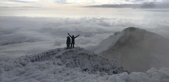
On summit day, we again leave long before dawn in order to have firm snow conditions. We first climb nonglaciated slopes and then ascend a series of uniform snow and ice ramps of 30 and 35-degrees to reach a glacial platform at around 5,200m/17,000ft. As dawn approaches, we enjoy one of the most spectacular colour displays in the Andes. Almost every morning, the sun rises over a low trail of clouds which drift in
from the tropical forests of the Amazon Basin. As the sun moves further above the horizon, we are treated to a magnificent array of colours in the clouds, on the multi-hued soils and rock faces of the parkland, and on the massive glacial slopes of 5,704m/18,714ft Antisana, which rises to our north.
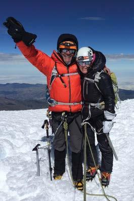
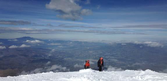
We belay across snow bridges, skirt large crevasses and ascend occasional short steep slopes towards the huge summit cone. We reach the base of the 120m/400ft rock wall Yanasacha (meaning “Black Wild Place” in Quechua) and encounter a gaping bergschrund at the base of the final glacial slopes that we must climb. We traverse out to the far end of the bergschrund, make an easy descent to its floor and then return to a point below our original position to reach a climbable section of its upper wall. A belayed 10-foot move on steep ice puts us on the 55-degree face and from there, we belay up some of the most enjoyable snow and ice climbing pitches in Ecuador. The gradient eases off as we reach the crater rim and from here it is an easy 10-minute climb to Ecuador’s second highest summit. At the top, we enjoy views of nine major equatorial peaks, the seemingly limitless Amazon Basin to our east and Cotopaxi’s spectacular 300m/1,000ft deep summit crater.
Chimborazo is Ecuador’s highest peak. A massive, 5-summited mountain, it is visible from Colombia in the north, near the Peruvian border in the south and from far out in the Pacific Ocean. This is a much more complex volcanic peak than almost all others of its type, showing many faces that offer a wide range of challenges to alpine climbers. The Southwest Face is moderately steep and pleasantly varied, including slopes from 25–40 degrees, a short gully climb as well as time on both névé and hard glacial ice. This mountain’s great height combined with our route’s requirement of diverse climbing techniques make this ascent a significant accomplishment.
From Cotopaxi, we drive south and then move up onto Chimborazo’s eastern flank to reach a small lodge at 3,499m/11,480ft, with views of the altiplano surrounding Chimborazo and Carihuairazo. Our vehicle then takes us to the western side of Chimborazo and at around noon, we reach the Carrel Hut (4,800m/15,700ft), where we enjoy some lunch. The afternoon is used to complete a 2-hour hike to Stübel Camp (4,900m/16,100ft), where we will spend the night. Climbers carry their own personal gear to camp while porters carry water, tents and food.
Of our days spent in Ecuador prior to our summit climb of Chimborazo, seven are normally at 4,650m/15,250ft or above and by this point in the itinerary, members of the group should be well acclimatised. That acclimatisation, plus the additional conditioning that has occurred on the other peaks, allows us to make this ascent in a single day from the hut. Though it is a long climb, these factors have brought an extremely high rate of success to our climbing teams.
Starting the climb at midnight, our route will take us up the tongue of the Stübel Glacier through sections of 40-degree snow and ice, eventually bringing us to the crux of the route. This varies with conditions but can be a short pitch of belayed climbing on snow and ice between 50-60 degrees.
From the summit, the panorama encompassing Ecuador’s many other glaciated peaks is superb. The views during the climb, the intricacy of the route and the variety of moderate technical challenges encountered make the ascent of the world’s highest equatorial summit an important achievement for both developing and experienced alpine climbers. Summit day will take between 10 and 14 hours return. We will descend to Carrel Hut and then continue on to the mountain valley town of Riobamba.
Should Day 13 be needed to wait out inclement weather, we will make our summit climb on this day. If we climb on Day 14, we will hike out after our ascent and drive directly to Quito.
To climb these peaks you need to be physically fit, have strong mental stamina and be capable of strenuous exercise for several days duration. Expedition members
can expect to exert themselves for about six hours per day and should be capable of carrying a 20kg/45lb pack.
Climbing at altitude affects people differently but most climbers notice a lower performance rate than normal. Our climbing days are mostly short to accommodate this and we incorporate vital rest days. Our graduated acclimatisation program allows you to progressively consolidate your fitness.
This expedition is suitable for those who are relatively new to mountaineering or have had some previous experience. Climbing skills and techniques will be instructed by your guides during the expedition.
The team will have a minimum size of 4 members and 2 guides.
Trip 1: January 11–25
Trip 2: February 1–15
Trip 3: February 15 to March 1
Trip 4: May 3–17
Trip 5: May 17–31
Trip 6: June 7–21
Trip 7: July 5–19
Trip 8: November 1–15
Trip 9: November 15–29
Trip 10: December 6–20
Trip 11: December 20 to January 3, 2026.
Private departures are available upon request throughout the year.
Following is an ideal itinerary for our Ecuador Volcanoes Expeditions:
Day 1 Arrive Quito, hotel night
Day 2 Gear check and acclimatisation hike of Ilaló, hotel night
Day 3 Acclimatisation hike on Cerro Pasochoa, hotel night
Day 4 Acclimatisation hike on Rucu Pichincha, hacienda night
Day 5
Travel to Cayambe, hut night
Day 6 Skills practice on Cayambe, hut night
Day 7
Day 8
Day 9
Summit Cayambe, hacienda night
Travel to Cotopaxi region, hacienda or lodge night
Travel to Cotopaxi National Park, hike to José Ribas Hut, hut night
Day 10 Cotopaxi Summit, lodge night
Day 11
Travel to Chimborazo, lodge night
Day 12 Hike to Stübel Camp, camp overnight
Day 13 Chimborazo Summit—either travel to Riobamba or camp at Stübel Camp
Day 14
Contingency Day. Return to Quito, hotel night Day 15 Depart from Quito
Generally, entry visas are not required for travellers staying less than three months in Ecuador but please check with your travel agent. Climbing permits are a separate matter dealt with by the expedition agent.
Flight arrangements should be made so that you arrive in Quito on or before Day 1 of the trip and you depart on or after Day 15 of the trip.
During the expedition, you will enjoy high quality Western-style food as well as popular local dishes. Please indicate any specific dietary requirements you may have on your application form.
Expedition members will be sent a list detailing all the necessary clothing and equipment to be individually procured, contained within a set of Expedition Reference Notes. These notes provide extensive information on everything from suggestions on the type of camera to bring to training advice for your expedition preparation.
Expedition members will be provided with a medical questionnaire by the expedition doctor and asked to visit their family physician to receive a full medical examination. This information will be sighted only by our medical adviser and the Expedition Leader and treated with full confidentiality.
Advice on immunisations will be provided at this time. We also require members to have rescue insurance and we will consult with individual team members as to your insurance needs and solutions for coverage.
Expedition members will need to provide 3 passport photographs for various climbing and trekking permits, plus a copy of their passport biodata page.
The cost of the scheduled expeditions, ex Quito, Ecuador is US$5,040 per person.
The cost of private departures is available on request.
These are inclusive costs and covers the following:
• Qualified and experienced mountain guides
• All expedition organisational requirements
• Land transport within Ecuador
• Lodging in hotels, haciendas, huts and tents on a shared basis during the expedition
• All trek and mountain food ex Quito, excluding lunches and dinners in hotels, haciendas and lodges
• Group equipment: ropes, tents, stoves etc. and all supplies necessary to make a safe and strong bid for the summit(s)
• Porters on Chimborazo for carrying group equipment
• Climbing permits
• National park fees and admission to museums
The expedition fee does not include the following:
• Personal clothing and equipment
• Personal/trip cancellation/medical evacuation insurance
• Lunches and dinners in Quito and when staying at hotels, haciendas and lodges
• Extra nights in Quito
• Personal expenses such as alcohol, gifts, etc.
• Return flights to Quito, Ecuador
• Excess equipment over the 20kg per person allowance
• Porters on Chimborazo for carrying personal equipment
• Any rescue costs
• Government and airport taxes
• Inoculations
• Gratuities
All payments should be made by bank transfer to the following bank and account:
Bank of New Zealand
Offshore Branch 42 Willis Street Spark Central Wellington New Zealand
for the account of Adventure Consultants Limited.
Account Number: 1000-594771-0000
Account Type: US Dollars
Swift Address: BKNZNZ22
NOTE: All bank transfer charges are for the remitter’s account.
We can also accept your deposit and balance payment by credit card (Visa, Mastercard and Amex) plus a 3% card charge.
A non-refundable deposit of US$500 is payable to secure a place on the expedition.
The balance of payment is due 90 days prior to your expedition start date.
An expedition member may cancel their participation on the following basis:
• Cancellations outside of 90 days will result in the loss of trip deposit.
• For cancellations made within 90 days of the trip commencement date we reserve the right to retain 50% of the balance payment fee.
• For cancellations within 60 days of the departure date a cancellation fee of 100% of the full fee applies.
We strongly recommend you take out trip cancellation insurance via your travel agent if you wish to be covered against cancellation due to medical or personal reasons.
If you would like to join one of our Ecuador Volcanoes Expeditions, please sign up at https:// adventureconsultants.com/expeditions/south-america/ ecuador-volcanoes#DepartureBookingBlock.
If you require more information, please contact us at:
Adventure Consultants Ltd
5/12 Frederick Street PO Box 739 Wanaka, 9343 New Zealand
Phone: +64 3 443 8711
Email: info@adventure.co.nz Website: www.adventureconsultants.com

Adventure Consultants is affiliated to the New Zealand Mountain Guides Association (NZMGA), New Zealand Alpine Club (NZAC) and a corporate member of the American Alpine Club (AAC). Adventure Consultants is a supporter of the dZi Foundation in Nepal for their ‘Revitalise a Village’ programmes.
Adventure Consultants perform to IFMGA/UIAGM standards and are world leaders in high altitude guiding.