9 minute read
Seasonal Bushfire Outlook spring 2021 Australia’s national picture of fire potential


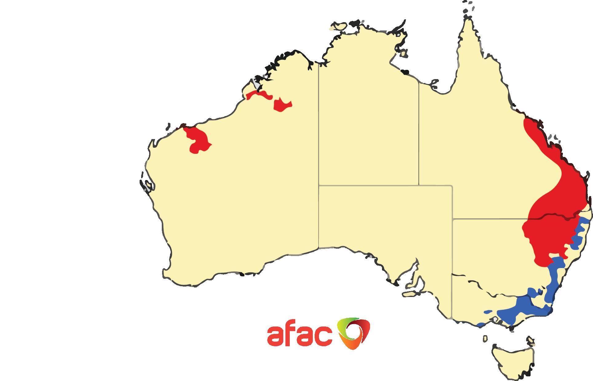
Seasonal Bushfire Outlook for spring 2021. Areas are based on the interim biogeographic regionalisation for Australia and other geographical features.
Above normal fire potential Normal fire potential Below normal fire potential
AFAC released the Seasonal Bushfire Outlook for spring 2021 on 26 August, forecasting varied fire potential for locations across Australia.
ALANA BEITZ
AFAC
BETHANY PATCH
Bushfire and Natural Hazards CRC
Fire potential can vary greatly, even at a smaller scale, between bordering states and territories. Each state and territory’s assessment considers different land use and vegetation types and is influenced by different forecasts for temperature and rainfall over these regions.
The spring 2021 Seasonal Bushfire Outlook predicts above-normal fire potential for conditions over southeastern Queensland and northern NSW, driven by grass and crop growth in these areas.
In WA, the above-normal fire potential in the north is driven by grass growth and dry soil in the area.
Below-normal fire potential is predicted across the ACT, NSW and Victoria as a result of vegetation recovering from the 2019–20 bushfire season.
While most of Australia shows normal bushfire potential during the spring outlook period, destructive and deadly fires can still occur during normal bushfire seasons across Australia.
AFAC CEO Stuart Ellis AM said the Seasonal Bushfire Outlook is an important tool for fire authorities to prepare their operational response within their own jurisdiction and beyond state borders.
“The outlook provides a national picture of what to expect over the coming months, and the evidence base to make key hazard reduction and strategic operational decisions to reduce bushfire impact on Australian communities,” he said.
“Increasingly, fire and emergency services work together to provide assistance across state and territory lines where needed. The outlook provides our Commissioners and Chief Officers Strategic Committee with the foresight to determine their collective capacity to share resources interstate if required.”
About the outlook
Fire management is a year-round process, and the outlook reflects the priorities in each state and territory for the coming months, given the expected climate conditions. It provides information to assist fire authorities in making strategic decisions such as
resource planning and prescribed fire management to reduce the negative impacts of bushfire.
This outlook was developed by AFAC; the Bureau of Meteorology; Queensland Fire and Emergency Services; the NSW Rural Fire Service; ACT Emergency Services Agency; ACT Parks and Conservation Service; Country Fire Authority; Department of Environment, Land, Water and Planning Victoria; Tasmania Fire Service; SA Country Fire Service; Department of Fire and Emergency Services in WA; Department of Biodiversity, Conservation and Attractions WA; and Bushfires NT.
AFAC acknowledges work of the Bushfire and Natural Hazards CRC and its predecessor the Bushfire CRC, who produced the Seasonal Bushfire Outlook for 16 years. With the conclusion of the Bushfire and Natural Hazards CRC, the outlook joins a range of successful research outputs that have transitioned and been adopted into practice by the end-user community.
Over the years, the outlook has adapted and developed as needed and as the science improved. With the move from a research output into an operational product, it will continue to be adapted and developed under the stewardship of AFAC. “The outlook provides a national picture of what to expect over the coming months, and the evidence base to make key hazard reduction and strategic operational decisions to reduce bushfire impact on Australian communities.” Stuart Ellis AM, CEO AFAC
Recent conditions
Seasonal fire conditions are a function of fuel (vegetation) amount and dryness, and recent rainfall and temperatures.
The year to date has seen aboveaverage rainfall for many areas, with a few notable exceptions: the central coast of Queensland and an area of south-east SA extending into western Victoria and south-west NSW all experienced below-average rainfall for the eight-month period.
Australia’s recent climate has been affected by a negative Indian Ocean Dipole (IOD) event. Negative IOD events typically increase the likelihood of above-average rainfall across large parts of eastern and southern Australia during winter to spring, especially the south-east, as occurred in 2016 when a negative IOD saw Australia’s wettest May to October period on record.
This year’s event is likely to be much weaker than 2016, although that does not remove the risk of flooding in some areas of the greater south-east. Typically, negative IOD events end in late spring to early summer, and if they are not accompanied by La Niña events (which can extend wet conditions into summer), there can be a quick return to average or even drier or warmerthan-average conditions. This can rapidly cure abundant winter and spring growth.
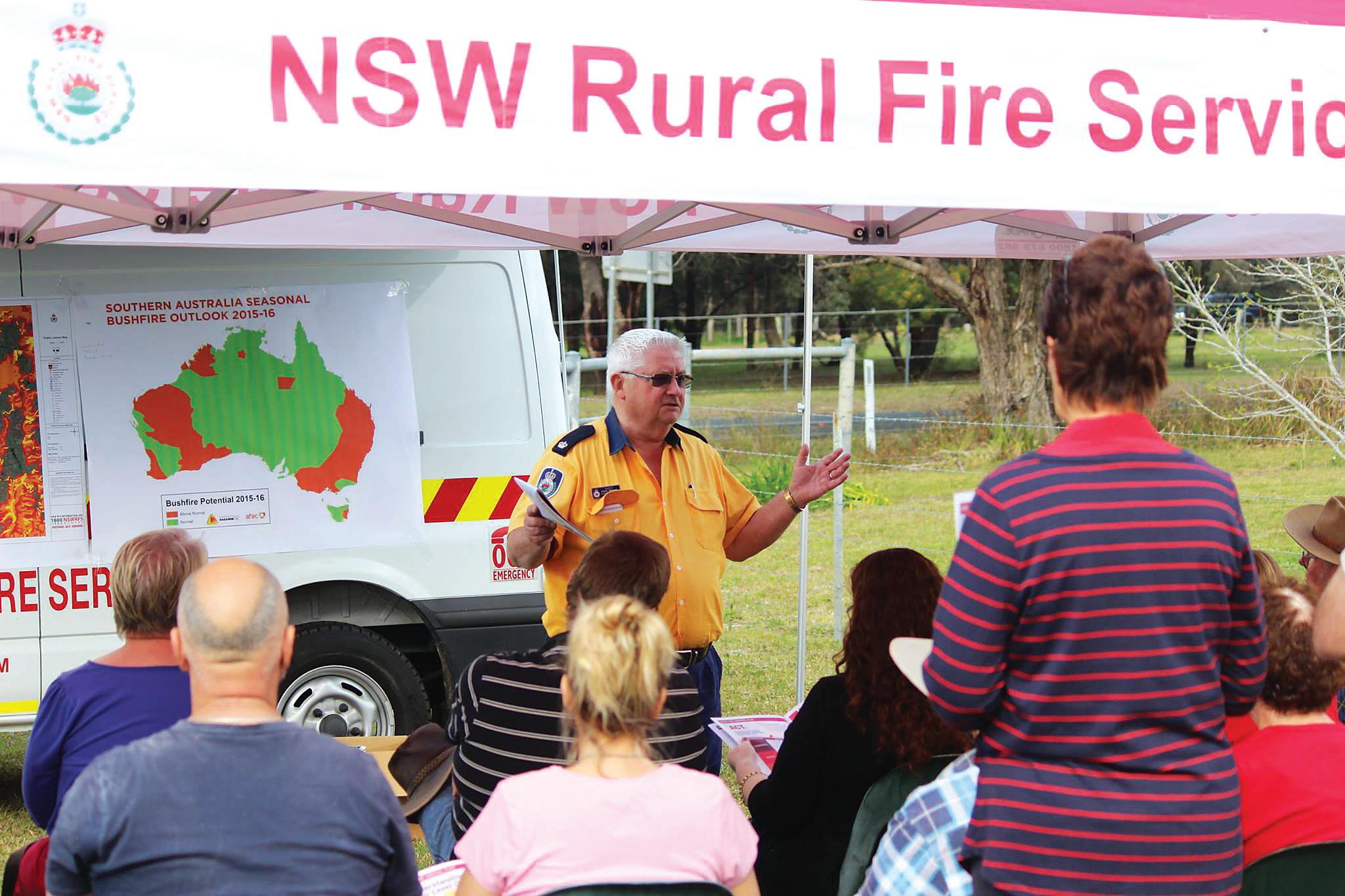
The Seasonal Bushfire Outlook being presented at a NSW Rural Fire Service community meeting by David Stimson.
FIRE POTENTIAL DEFINITION:
The chance of a bushfire or number of fires occurring of such size, complexity or other impact that requires resources (from both a pre-emptive management and suppression capability) beyond the area in which it or they originate.
Fire potential depends on many factors including weather and climate, fuel abundance and availability, recent fire history and firefighting resources available in an area.
The long-term warming trend means that above-average temperatures now dominate most years, and recent months have generally followed this pattern, despite the cooling influence of the negative IOD in some areas. Averaged Australia-wide, the country experienced its fourth-warmest July since records commenced in 1910. A number of record-high July daily temperatures were set in 2021, including Australia’s second-warmest July day on record, which was set on three separate occasions during the month.
Across Australia, above-average rainfall and relatively cooler weather have eased fire risk for some areas, but this has also meant increased vegetation growth in many areas. However, July rainfall was not enough to clear rainfall deficiencies present across the central coast of Queensland, and below-average rainfall was observed across eastfacing coastal areas of the south-east, including Tasmania. August saw drierthan-average conditions across much of southern Australia, and this will continue to be monitored.
Year-to-year variability can counteract long-term trends in increased severity and length of fire seasons. While fire seasons can be more benign during La Niña and negative IOD years, the tendency for fire seasons to have elevated fire dangers more frequently, and for elevated fire danger to occur earlier and later in the season is a clear trend in Australia’s climate. This reflects reduced and/or less reliable cool season (April to October) rainfall in southern parts of the country and rising temperatures. Fire season length and severity is increasing across much of Australia as measured by annual (July to June) indices of the Forest Fire Danger Index, with increases tending to be greatest across inland eastern Australia and coastal WA.
The full Seasonal Bushfire Outlook for spring 2021 is available from the AFAC website and includes further details on each jurisdiction’s fire potential: www.afac.com.au/ docs/default-source/bushfireseasonal-outlook/seasonaloutlook_ spring_2021_v1-0.pdf.
BUILDING ON 16 YEARS OF THE SEASONAL BUSHFIRE OUTLOOK
After 16 years of being produced by the Bushfire CRC and then the Bushfire and Natural Hazards CRC, the Seasonal Bushfire Outlook has been handed over to the enduser community. As Natural Hazards Research Australia develops its new research program, the outlook joins a suite of research outputs that have been successfully adopted by the wider emergency services sector, government agencies and community organisations for use and application.
The outlook began in 2006 as part of a Bushfire CRC research project with Dr Graham Mills from the Bureau of Meteorology (BoM), with the intention being to provide a map of ‘bushfire potential’ alongside expert commentary on state and territory conditions and climate conditions and forecasts. The first outlooks were produced with the expertise of Dr Tim Brown from the Desert Research Institute, who developed a similar product in the United States.
The development of the outlooks has been an ongoing process between the CRC, BoM, emergency service agencies in each state and territory and, in recent times, AFAC’s Predictive Services Group—demonstrating the power of collaboration at a national and local level to create a meaningful and useful product that can be used by all states and territories, the media and a wide variety of government and community organisations.
The first outlooks were released prior to the southern fire season, around September. Later, a northern outlook was added to the annual cycle, released around June, which captured the unique fire season across northern Australia. A Seasonal Fire Danger Outlook for New Zealand authorities was also developed. In 2020, the Bushfire and Natural Hazards CRC shifted the publication of the outlook to a national quarterly release to better reflect the year-round nature of fire management and operations across Australia.
The outlooks are prepared at collaborative workshops by integrating climate forecasts with extensive knowledge of the current state of vegetation, as well as of previous fire seasons, to produce an overview for the upcoming fire season. The workshops consider the weather, landscape conditions and cross-border implications leading into the main fire season. Workshop members work together to create a map that shows ‘fire potential’ across the country, in three colours signifying above-normal, normal and belownormal potential.
Over time, the definition of ‘fire potential’ has shifted slightly to become “the chance of a bushfire or number of fires occurring of such size, complexity or other impact that requires resources beyond the area in which it or they originate”. This allows for cross-jurisdictional awareness and collaboration, especially in state or territory border areas.
WHO USES THE OUTLOOK?
The outlooks have come to serve a range of highly beneficial purposes for different audiences and are a critical component in raising community awareness about the coming fire seasons around the country. They also provide a great opportunity for agencies to speak directly about any preparations underway to mitigate the impacts of the upcoming fire season, and they align these preparations with the most up-to-date weather and climate science directly from BoM.
Governments and fire authorities use the outlook for strategic decisions, resource allocation, prescribed fire management and planning purposes in the lead-up to their bushfire seasons, including refining public messages that communicate bushfire risk and highlight areas with the highest potential for fire. The ways that agencies and governments make use of the outlooks for planning varies. Emergency Management Australia uses the outlook to advise the Federal Government and relevant departments. It is regularly tabled in state parliaments as a demonstration of the state’s preparedness. Agencies commonly use each outlook to justify significant investment in resources, such as additional firefighters, vehicles and aircraft. Another key use is to increase community preparedness campaigns in areas with high likelihood of fire.
The outlook is now also widely distributed among related organisations and community groups for local use. The Australian Red Cross uses it to produce hazard and vulnerability data maps for its emergency service managers around Australia, as part of its seasonal preparedness planning, so that resources can be shifted to areas with higher fire potential. ABC Emergency uses the outlook to schedule training sessions for its journalists working in potentially hazardous areas around the country, based on the priorities highlighted by the outlook. Many private companies and government agencies also use it as a way of understanding their need for preparedness for the coming season.


