
15 minute read
The Aral Sea and Colorado River: Lunar scenery, striking parallels, and unexpected lessons for Afghanistan
Authors:
Going places helps to see bigger things, more so, it helps seeing common denominators for diverse human activities. An ecological imbalance, we, humans, bring about in many geographical areas is one of them. In search of such an unfortunate denominator a group of environmental experts, comprising two Afghans from Balkh University (Mazar-e-Sharif, Afghanistan), and the project leader from the Asian Institute of Technology (AIT) visited one of the world’s major environmental disaster areas – the drying Aral Sea in Central Asia. The group assists British Council’s DelPHE program to build capacity for water protection in Northern Afghanistan through Strategic Environmental Assessment, also known as Strategic Environmental Impact Assessment (SEIA). The trip was inspired by work of the Amu Darya Basin Network established by the East West Institute in Brussels. Logistics were facilitated by Berdakh and Marat Utemuratovs from Karakalpakstan, the area of western Uzbekistan most affected by water shortage.
Advertisement
In the second half of twentieth century, the Aral Sea “unexpectedly” fell prey to a voracious appetite of human development machine requiring ever-increasing volumes of cotton. The monoculture was notorious for excessive water consumption imposing an unsustainable water burden on Amu Darya, the river, which feeds the sea. Post-Soviet imbalances between energy and irrigation needs in Central Asia further offset the precarious desert equilibrium. On top of this, the situation was possibly exacerbated by a natural fluctuation of water resources in the region, decreasing at the period while the neighboring Caspian Sea level rose.
Three Soviet republics were a closed club of large-scale users of Amu Darya water. Nowadays, after decades of absence, Afghanistan gradually, but inevitably, comes back to the club. Complex multilateral negotiations still lie ahead. But the historic Aral Sea trip by Afghan scholars paves the way towards a dialogue between people of the upstream and downstream. Strategic water security is one of the keys to emerging long-term stability in Afghanistan. Strategic Environmental Assessment (SEA) would serve the purpose of ensuring that water resources for regional and Afghan agriculture uses are sustainable in the long run. Afghan water environments (rivers, underground kareze, irrigation canals, and natural wetlands) are stressed due to a long period of conflict. To avoid environmental collapse the post-conflict country is in need of strategic environmental planning. SEA offers an effective procedure for evaluating likely adverse or positive environmental impacts of proposed development projects, plans, and policies. By identifying ways of improving project selection, planning, design, and implementation, it enhances the quality and sustainability of human activities.
Oleg Shipin, Ph.D.
Associate Professor, Environmental Engineering and Management, School of Environment, Resources, and Development, Asian Institute of Technology (AIT)
Habibullah Habib, Ph.D.
Chancellor, Kabul University Afghanistan
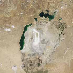
Measuring 300 km across, the Aral Sea was this size in 20th century until the 1960s Now, the fragmented remainder of what was once the 4th world’s largest inland water body

Classical river upstream-downstream connection. Lower Amu Darya basin (field trip destination) and Northern Afghanistan (British Council project’s focal area).
Muynak town, Western Uzbekistan. White sun, dunes, and fishing ships. The Aral Sea? Alas, welcome to Aralkum (Aral Sands), now a Karakum desert’s brother! The Easter Island “in-the-desert” is gradually losing its civilization. Blending with the wasteland here, turning into a desert there, it may as well bounce back in some centuries. It happened before. There was a town with an irrigation network in the time of the Great Mongol Empire. It later ended up under the rising Aral Sea but is now once again fully exposed to the sun and wind. The history repeats itself, and these days it is Karakalpakstan’s turn.

British Council’s DelPHE program (Developing Partnerships in Higher Education) brought the Asian Institute of Technology, Thailand, to partner with the Balkh University, Afghanistan, on water and other environmental issues of Central Asia. Notoriety of the Aral story is in its sheer and unprecedented size but ancient history abounds in cases of large-scale development degrading natural ecosystems. We made mistakes time and time again when our activities have been dramatically changing whole landscapes on all continents. Take the demise of great civilization in Mesopotamia (Babylon, Ur), when very specific Nile irrigation practices of old were thoughtlessly transferred from the Ancient Egypt and slowly, over centuries, lead to desertification of fertile lands between Tigres and Euphrates.
On the exact opposite side of the globe, in the Pacific Ocean, a mysterious Easter Island has another spectacular story to tell of its resources grossly overused and of a subsequent demise of civilization. It also started with humble human development and eventually went out of balance with nature. Then invading alien species, particularly rats, brought in by this very development, have dealt a decisive blow to the already ailing civilization. Famous giant stone heads serve as reminders of the days of former glory. Another case is the transboundary Dead Sea in the Middle East. The story of its recent drying is in the same vein - fresh water diversion for human needs offsets a millennia-old hydraulic balance. Remainder of the Aral Sea steers towards another “dead sea” scenario, with its salinity still threefold lower, but increasing by every year and sure to reach saturation in the near future. Yet another dead sea on the record and conscience of humanity.
SEA is impossible without accounting for cumulative impacts (effects) of human development on the environment. Excessive use of water, pollution, erosion and numerous other anthropogenic impacts are frequently synergizing and cause substantial negative integrated impacts, which lead to environmental disasters, immediate (landslides, sandstorms, and health problems) or slow developing (desertification and droughts). Furthermore, climate change significantly increasing annual melting rate of glaciers in Central and North East Afghanistan further exacerbates environmental stress and imparts urgency to strategic measures of adaptation to future water use prospects.
The DelPHE project deals with the impacts through the development of the Cumulative Effects Assessment (CEA). CEA for the Amu Darya as a whole, and specifically for its Afghan Basin is long overdue. Balancing the use of water resources in between energy and agriculture is one of the aspects. Salinization, over-fertilization, and accumulated pesticides in the top soil are cumulative impacts which are known to inflict dramatically enhanced blows to the local population and ecology.
To really come up with a rationale for sustainability for Afghanistan and, in a broader sense, for the region of Central Asia, it makes sense to take a wider, global view of our environmental errors and lessons learned. It was worthwhile to get up close and personal with the way US authorities learn their lessons to provide for the future of the Colorado River Basin. Most of their moves are surprisingly relevant to Afghanistan.
Recent DelPHE project discussions with the universities and water authorities in the Colorado River Basin was yet another quest for solutions to the Afghan environmental conundrum. All arid regions are alike to a great extent, even in such countries of different history and socio-economics as the United States and Afghanistan. The Colorado River Basin story, is

Dried Aral seabed near Muynak, Western Uzbekistan. Cruelly spectacular victim of human drive to dominate the environment, formidable fishing fleet is stalled forever in the waves of sand or gone to scrap metal. Ultimate masters of the desert, hardy saxaul trees, take over, both naturally and with a welcome German and French assistance.
as glamorous as Las Vegas and Los Angeles sitting on its water, and nearly as ecologically sad as the Aral Sea’s less publicized predicament. It offers surprising insights into relationships of man and water cruelly mediated by human development, kind of a Tale of Two Cities and only One River.
Colorado River provides for 30 million people, and still fast growing, but at the expense of the natural balance, which is negative for many decades. The river lost two thirds of its might and most of its ecological integrity, and ultimately ceased to normally flow into the Gulf of California for over half a century. Being the most important source of water in the South West, encompassing Arizona, California, Colorado, and Nevada, it supports 16,000 km2 of irrigation, and 4.2 GW hydropower infrastructures. The river also critically caters to 15 tribes of Native Americans, 12 national wildlife refuges and parks, and 4 recreation areas. Imbalances in water supply and demand, which already occur in the basin, are projected to increase further in view of climate change and further uncontrolled development. To an extent, these challenges are met by the capacity of numerous artificial river reservoirs to store about four times the average inflow.
Thinking about downstream while engaging in upstream activities is obvious. Thinking about the intertwined past and future of Amu Darya and Colorado River is a quantum leap forward. Tamarisk bush is just one common denominator. An aggressive invader, also known as salt cedar, is an ironical “present” to Colorado from Amu Darya. It is naturally abundant along the banks of Amu Darya and on the dried Aral Sea bed. Introduced to stop erosion it worked marvelously, until environmentalists realized that it stifles the Colorado River and wreaks havoc in its ecology.
The Colorado River Basin (CRB) Water Supply and Demand Study, equivalent to SEA, is currently being carried out in which all stakeholders take part. These are environmental organizations, native tribes and communities, hydropower and recreational authorities, and other Federal agencies. The main objectives are to assess future water supplies and demands up to 2060 and to evaluate the reliability of the Colorado River system to meet the needs of Basin resources, such as hydroelectric power generation; recreation; fish, wildlife, and their habitats; water quality; and flood control. Ultimately this is being done with a view of developing adaptation and mitigation strategies to address future water supply and demand imbalances.
The CRB Study anticipates that the likely options to address future water supply and demand imbalances will include (i) increased supply through importation, desalination, reuse, local supply, and watershed management; (ii) reduced demand via municipal and industrial conservation, agricultural water conservation, increase use of efficiency in the energy sector, and system storage reoperation for Lower Amu Darya basin, Karakalpakstan, Western Uzbekistan. Where Amu Darya ends, a debate starts. Mr. Mohammad Qaasim and Dr. Habibullah Habib Chancellor of Kabul University, Afghanistan discuss how we all are interconnected: Afghans (upstream) and Karakalpaks (downstream) of the Aral Sea. The role which educational and research organizations, such as universities, play in the complicated strategic environmental planning and management is critical since universities combine functions of both impact prediction and capacity building. The DelPHE project strengthens capacity for SEA in Afghanistan and facilitates activities of the government and NGOs.


Grand Canyon, Arizona, United States. A squirrel’s immediate concern is what is happening here on the Colorado plateau, and whether it is ecologically comfortable at these heights. What is down there, at the Colorado River’s level, is another affair, a much tougher story. One can barely discern in the gorge’s depth a tight green belt of Asia’s “present”, tamarisk bush invading riverbanks increasing soil salinity, flooding, and fire frequency. On top of it, there are several major dams upstream and downstream, completely new, non-indigenous fish population, and intensive water abstraction for irrigation changing hydraulic regime. These are a few of the present concerns and some cumulative effects.
Gleaning environmental lessons and water-related experience to help the Afghan environment. The humbled Colorado river, now just a shadow of its former glorious past, was known through its murky abrasive power to chisel off granite of the plateau, creating an awesome canyon over a million years. And all those eerie features in the mist: Cheops pyramid, Krishna shrine, Solomon temple, and Zoroaster’s canyon. All arid regions are alike to a great extent, even the United States and Afghanistan, countries with very different history and socio-economics. Historical formula is sadly straightforward: an uneven distribution of water resources overlaid on fragile ecosystems multiplied by human activities out of touch with natural balance, eventually reduced to a common denominator of ecological degradation. Major environmental sore of the Salton Sea in the lower basin is just one example.
reduced evaporation; (iii) operations modification including groundwater storage, hydropower optimization, basin-wide water banking, and market driven water transfers and exchanges; and (iv) governance interventions such as control of development growth, funding of basin-wide programs, enhanced data and information sharing, tribal water use and transfers, resolution of water claims, reallocation of state apportionments, etc. Given that environmental awareness and recognition of water related problems exist across Afghanistan, it is believed that none of these interventions are impossible even in their simplest and more cost-effective versions if only the necessary policy and institutional preconditions are met.
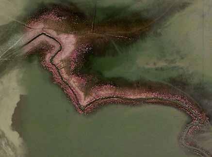
The DelPHE project uses mobile devices and Google maps to track recent environmental, landscape, and land use changes in its capacity building effort to boost environmental management in Afghanistan. The 21st century tool used by AIT and BU students is powerful enough under the field conditions, to discern tamarisk blooming along one of the remaining Aral delta wetlands.
The comparison between two rivers is striking not only from the ecological point of view. Situated at same latitudes with similar climates, the Colorado River and the three-fold greater in flow Amu Darya support roughly equal populations.
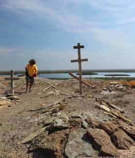
Urga, an abandoned fishing village on the Aral Sea reminds us to heed lessons of the past while looking forward to the sustainable future. People left the place decades ago: no fish – no jobs. Then, later, freshwater came back as Sudoche Lake through the efforts of the International Fund for Saving the Aral Sea (IFAS).

Las Vegas, Nevada, is a glorious oasis in the desert
sea. McDonald’s leads the way reminding us that human survival or prosperity in the South West is contingent on such seemingly humble initiatives as saying good bye to a quintessential American lawn and embracing more locally appropriate vegetation landscapes fed by more economical drip irrigation. Mazar-e-Sharif, Northern Afghanistan. Dredging a mirhab irrigation canal on Balkh River near Mazar-e-Sharif in Northern Afghanistan. Such systems, primitive they may seem, are still instrumental in feeding the country. Balkh River and Kholm River ceased to flow into Amu Darya centuries ago, extensive irrigation may have seriously contributed. The DelPHE project strives to turn the mirhab networking into a broader environmental stewardship system, not just water management as it always was.

Further Reading:
H. Habib, A.J. Anceno, J. Fiddes, J. Beekma, M. Ilyuschenko, V. Nitivattananon, O.V. Shipin (2013) Jumpstarting strategic water resources protection from a changing global perspective: gaps and prospects in Afghanistan. Journal of Environmental Management, 129, pp. 244-259.
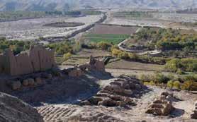
Kholm, Northern Afghanistan. The area covered by the DelPHE project and situated at the extreme opposite end of the Amu Darya basin, in the upstream foothills of Hindu Kush Mountains, these famous pomegranate gardens in the town of Tashkurgan in the North of Afghanistan, are in grave danger due to the very same cumulative impacts as tugai forests of the downstream. Home of magnificent ruins of the glorious past, they now face new challenges of the post-conflict Afghanistan, ironically due to the good news for the upstream river area where recent agricultural boom led to renewed and intensified water abstraction for irrigation, the practice which was discontinued for many decades of conflict. For the last centuries the river was not in a possession of enough water to reach its natural destination, Amu Darya. Arguably, as observations all over the world show, it happened gradually, at least partially, due to a historically protracted period of substantial water abstraction in its basin. One can see the irrigation canals creating an artificial “delta” making up traditional Mirhab system, a backbone of Afghan agriculture for centuries.
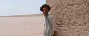
Dr. Habibullah Habib (former Chancellor of Balkh University, presently the Chancellor of Kabul University) explains that there is an interdependence of Amu Darya Basin ecosystems, e.g. this degraded pistachio forest and river floods. Capacity building is required to step up environmental education and management in Afghanistan and the DelPHE project does its bit through BU and AIT, while involving National Environmental Protection Agency of N. Afghanistan.
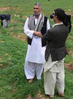
At times plainly dangerous, Amu Darya that night playfully swallowed up half of the house of this Turcoman in one of annual spring floods in the N. Afghan river basin. Strategic Environmental Assessment would surely help preventing such regular occurrences plaguing mainly Afghan side which in contrast to Tajik or Uzbek side is not only much lower, but also less environmentally fortified.
Bangkok, Thailand. Turning once-a-century disaster into an opportunity of a life time, project participants at AIT continued environmental work even during the stupendous October-December 2011 flood in Thailand. Asian Institute of Technology, the DelPHE project lead, being at the epicenter of disaster was under up to 3 m of water for over 2 months. Nature on rampage did not deter the team from learning about disaster management in the framework of SEA. Learning professional skills of disaster management from real life, Afghan students came back to the flooded AIT campus to come to terms with the cruel reality. The Flood itself was a result of cumulative environmental impacts and the lack of a comprehensive SEA in the local river basin in the Central plains of Thailand. Positive side of such unfortunate events is that they bring new ideas on how to prevent or handle impacts in an environmentally sustainable way while demonstrating disaster resilience, capacity to adapt and continue operation.

Performance-based Design: An Approach towards Safer, Reliable Structures


