
16 minute read
THE CHILKOOT TRAIL
The geography of Chilkoot Inlet played an important role in the history of Alaska. Rising straight out of its blue-green waters, the Coast Range stood as an almost inpenetrable barrier between the bountiful rivers and bays of the Inside Passage and the equally bountiful interior of rivers, lakes, and valleys. Each place provided a wealth of natural resources in fish, game, and vegetation, and the Native peoples who lived in these areas enjoyed a brisk trade in their respective stores of fish, furs, and other useful resources. There were, however, only a very few routes over the forbidding mountains, and whoever controlled those routes controlled the trade.
In his classic memoir, 'Old Yukon: Tales—Trails—Trials' (Washington Law Book Co., 1938) pioneer judge and congressman James Wickersham wrote about the indigenous history of the Chilkoot Inlet: “The Chilkat Indians, and their cousins, the Chilkoots, are members of the Tlingit nation, speak the same language, are divided into the same social clans, and are otherwise so closely related by blood and tribal customs as to constitute one people.
Advertisement
“For ages the Chilkats controlled the old Indian trade route from the Chilkat Inlet through their fortified village at Klukwan to the middle Yukon fur country; in the same way the Chilkoots, with the assistance of the dominant Chilkats, controlled the Dyea Trail over the pass to the lakes forming the headwaters of the Yukon River. The ownership and control of these two trade routes, through otherwise impassable mountain ranges, gave these warriors and traders a monopoly of the valuable trade with all the Stick (Tena) Indian tribes in the middle and upper Yukon basin, and made them the richest and most powerful tribe on the coasts of Alaska. They did not hesitate to attack any power that interfered with their age-old claims of established right to these trails and the control of trade over them. In 1852 they learned that the Hudson Bay Company’s trader, Robert Campbell, had erected Fort Selkirk at the junction of the Lewes and the Pelly rivers to control the fur trade with the Stick Indians in that region, all on the British side of the line. They immediately sent an armed body of their warriors from Klukwan over their Chilkat trail to that post, burned the buildings, carried away the goods, and gave the great English company notice not to rebuild the post, which command was obeyed.”
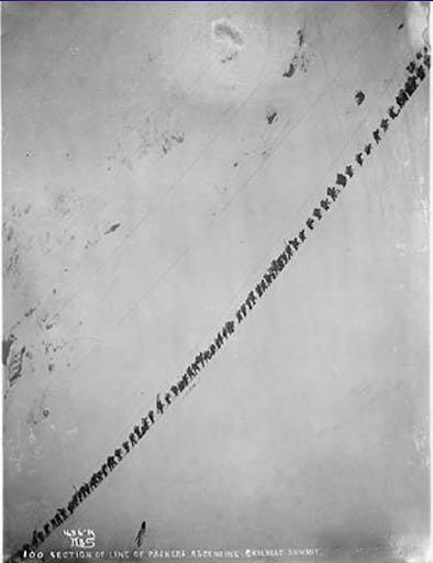
Line of Klondikers with supplies ascending Chilkoot Pass, Alaska, 1898. Caption on image: "Section of line of packers ascending Chilkoot summit copyright 1898.”
Photograph by Eric A. Hegg. University of Washington Libraries, Special Collections [Order No. HEG366]
Forty years later Arthur Harper would establish a store at the site, and around the same time, in 1879, a group of twenty gold prospectors from Sitka attempted to travel the trail up the Dyea River to Chilkoot Pass, but they were turned back by the Indians, who feared their monopoloy of the Yukon fur trade might be destroyed if the passes were opened to American gold hunters. Wickersham explained the historically important outcome of the confrontation: “The disappointed prospectors returned to Sitka and appealed to Captain Beardslee, commanding the U.S.S. Jamestown, stationed there for the protection of white traders. A naval launch carrying twenty armed sailors and a Gatling gun, under command of a naval lieutenant, escorted five sail boats filled with armed prospectors from Sitka to Chilkat Bay. After reading a letter from Captain Beardslee addressed to the Chilkat and the Chilkoot chiefs and assuring them the prospectors would not meddle in any way with their fur trade, the naval officer explained the Gatling gun to them, and they agreed to open the Dyea pass to the gold hunters only. On May 20, 1880, the Dyea-Chilkoot gate was first opened to white men, and the Edmund Bean party of twenty American prospectors passed through to the Yukon headwaters in search for placer gold.”
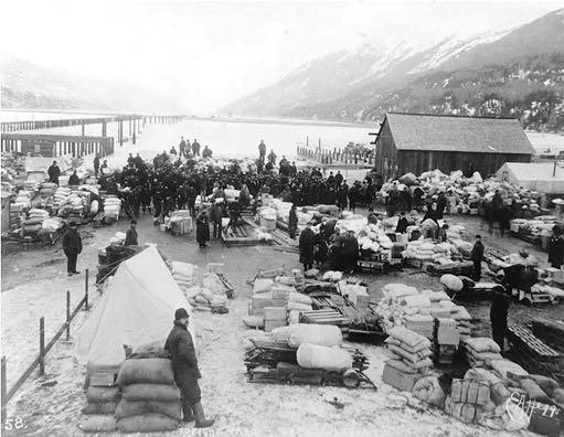
Freight and supplies near the Long Wharf, Dyea, circa 1898.
Photographer Eric A. Hegg. University of Washington Libraries, Special Collections, [HEG117]
While James Wickersham’s history is entertaining and mostly accurate, there is much more to the story, and one of the most comprehensive resources is the 2011 National Park Service publication, 'The Chilkoot Trail: Cultural Landscape Report for the Chilkoot Trail Historic Corridor.' This beautifully illustrated landmark work details the trail mile by mile, and provides the most compelling exploration of the route, variations of the trail, buildings, structures, artifacts, vegetation, cultural history and significance, with in-depth analysis and evaluation and over a dozen detailed maps, and it is available to download or read free online.
'The Chilkoot Pass' notes the Chilkat and Chilkoot Indians maintained four large villages and many seasonal camps centered around what is now northern Lynn Canal. One was Dyea (Dayei, or “packing place”), a seasonal fishing and harvesting camp for the Chilkoots, and a tidewater staging area for trade between the coast and the interior. From the booklet:
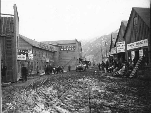
Businesses lining Trail Street, Dyea, Alaska, circa 1898.
Photographer Eric A. Hegg. University of Washington Libraries, Special Collections, [HEG114]
“Trade between the groups consisted mainly of the exchange of coastal products for furs and other products of the interior. To the north flowed clams, seaweed, dried fish, sea otter pelts and other marine products. In particular, eulachon (hooligan) oil, tendered from a cod-like fish, was an important commodity that the Tagish relied upon for nutritional and cooking needs, and gave rise to the Chilkoot route being tagged the ‘grease trail’ by Euro-American explorers. In exchange, the Tagish sent primarily fur stocks of moose, caribou, and beaver, among others, as well as lichen dyes and goat wool, south to the coast.”
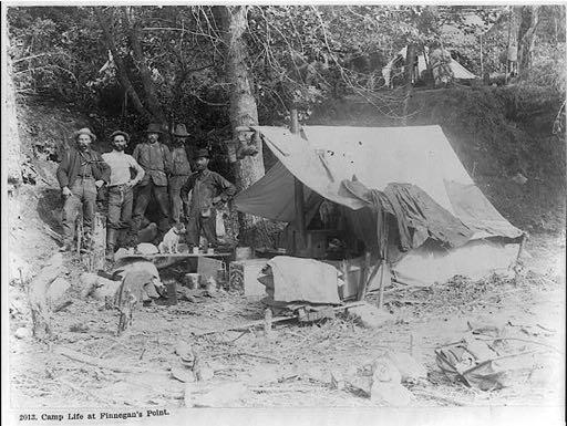
”Camp life at Finnegan's Point,” ca. 1897
www.loc.gov/item/2006690155/
The Dyea Trail, or as it would come to be known, the Chilkoot Pass Trail, began on the broad, flat flood plain delta of the Taiya or Dyea River. The trail ascended gently, following the 17-mile-long river through the mountains. After about 12 miles the trail began to rise sharply, gaining over 1,600 feet in just two and a half miles. Then the steep climb over the pass itself, followed by trails leading down the eastern flanks, where long lakes provided easier travel, whether by canoe or toboggan.
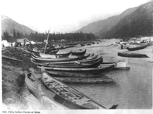
Forty Indian canoes at Dyea, ca. 1897
www.loc.gov/item/2004672222/
An early guidebook for Klondike stampeders was a slim volume titled Klondyke Facts (American Technical Book Co., 1897), written by Dawson City founding father Joseph Ladue, who crossed the Chilkoot Pass in 1882 with a group of fifty men bound for the goldfields. He described a questionable ‘first crossing’:
No mention is made of George Holt in the NPS booklet, but it does give credit to Drs. Aural and Arthur Krause, brothers who worked under the auspices of the Geographical Society of Bremen, Germany.
In late May of 1882, Krause and two Tlingit guides prepared “to go over the Dejäh Pass to the Yukon Lakes,” and there are details of their trip in the NPS booklet. “Krause’s mapped route, and its narrative description, reveals the existence of a well-defined Tlingit trail corridor based on the traditional ecological knowledge of the environmental conditions (seasonality, currents, terrain shifts, available resources for harvest).”
A year later, in April 1883, First Lieutenant Frederick Schwatka was dispatched to lead the Alaska Military Reconnaissance in assessing the increasing disturbances of peace between the Indians and whites in the area. Schwatka’s reconnoiter, utilizing Krause’s map, resulted in the first American survey of the Taiya River valley and the trail over Chilkoot Pass. Again, details of the journey—and comparisons with Krause’s—can be read in the online NPS booklet, which continues the history of the area:
“After the Krause and Schwatka surveys of 1883, a small trading post was established near the Dyea Tlingit encampment sometime between 1884 and 1886 by Edgar Wilson and John Healy. At the time, most of Dyea’s Tlingit, including men, women, and children, were engaged in the packing and transporting of goods for an increasing number of prospectors, surveyors and scientists. The arrival of a trading post at the small Native village was the first indication that control of travel and commerce on the Tlingit-dominated trail was about to change in dramatic ways.” No one could have foreseen how dramatic the change would be. The discovery of gold in the Fortymile district in 1886 led to an ever-increasing parade of miners and prospectors through Dyea. But it was the August 17, 1896 discovery of gold on a creek named Bonanza, a tributary of the Klondike River, itself a tribuary of the Yukon, which changed everything.
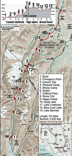
National Park Service map - view at http://www.nps.gov/klgo/planyourvisit/ images/BIGtrailmap.jpg
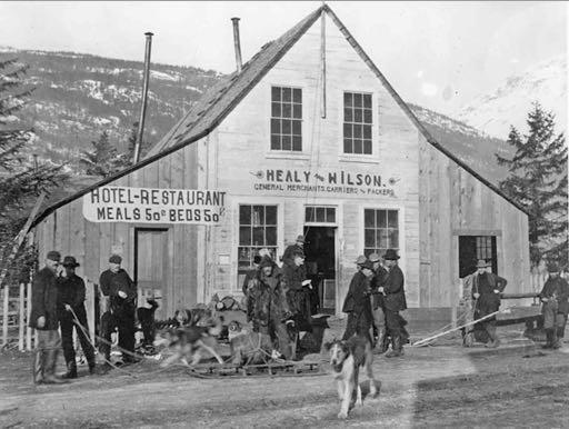
Healy & Wilson trading post, Dyea, c. 1898. Not much is known about Edgar Wilson, but his brother-in-law John Healy had been a soldier, guide, Indian scout, hunter, trapper, editor, and even a sheriff before coming to Alaska.
[National Archives, BR-1-A-10C]
On July 14, 1897 the S.S. Excelsior docked in San Francisco and sparked a fevered interest among the veteran California gold miners. Three days later the S.S. Portland arrived at the port of Seattle with its legendary ‘ton of gold,’ and the west coast—indeed the entire nation—went mad for the Klondike diggings. A special edition of the Seattle Post-Intelligencer desclared in bold headlines “Gold! Gold! Gold! Gold!” and local outfitting stores began emptying their shelves overnight, as men and women hastily grabbed for whatever supplies they could and caught the next ship north. Where there had been a trickle of hopeful prospectors searching for another El Dorado, there was now unleashed a flood tide of humanity in all its incarnations. Over the next few years an estimated 100,000 stampeders would join the rush to the north, and the bulk of them were headed for Dyea.
There were other routes, to be sure, such as the White Pass Trail out of nearby Skagway, of which Samuel E. Moffett wrote in 1903, “By the White Pass route you did not have the precipitous ascent of the Chilkoot, but you had to go twice as far, and you struggled through bogs in which you were likely to leave your horse and, perhaps, your entire outfit as well. The whole trail was blazed by the carcasses of dead horses.”
That passage would come to be known as The Dead Horse Trail, but when the White Pass and Yukon Railway was completed in August, 1900, it quickly became the route of choice.
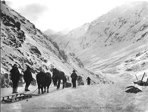
Horse drawn sleds looking toward Sheep Camp, 1898.
Photograph by Eric A. Hegg. University of Washington Libraries, Special Collections [HEG120]
The Dalton Trail over the old Chilkat Pass was easier, but it could only be used when the glaciers were not melting and the river levels were low, which translated to early spring when only the lower-level snows had melted, and just before freeze-up in the fall. The Dalton Trail was also considerably longer than the other two, being 300 miles to water transportation as opposed to 40 or 50 miles on the Chilkoot and White Pass Trails.
These three were the only non-glaciated passes over the Coast Range in an area stretching from south of Juneau to north of Yakutat. Whatever the route, a trip to the Klondike was not to be taken lightly, but the trip over Chilkoot Pass could be an arduous undertaking. This was made evident in a report by Frederick Funston, who would later gain recognition as “a giant of American military history.” He wrote, “Four of us were landed with our effects at the head of Dyea Inlet, a hundred miles north of Juneau, at daybreak on April 10, 1893. My three companions were McConnell, a grizzly old Canadian, Thompson, a miner from Idaho, and Mattern, a good-natured German, who had mined in half a dozen western states. I was the only one of the party who had had any previous Alaskan experience, but all had roughed it in other countries, and we felt equal to the much-vaunted terrors of Chilkoot Pass, Miles Canyon, and the Whitehorse Rapids. McConnell, Thompson, and Mattern were bound for the placer goldmining camp of Forty Mile Creek, at that time the only one on the Yukon, while I had a sort of roving commission from the United States Department of Agriculture to make a botanical collection, take weather observations, and obtain any other scientific information possible…”
“Near our landing-place was a small Thlinket Indian village of Dyea, whose inhabitants turn an honest penny every spring by assisting miners bound for the interior in packing their supplies to the summit of the pass. We divided our goods into seven packs and engaged five men and two women to carry these loads to the summit of the pass, a distance of fifteen miles, where they were to leave us to our own devices.”
The party left on the second day after arriving on the beach, and Funston noted, “The Indians supported the loads on their backs by the aid of deerskin bands, passing across the forehead. Several children carried on their backs light loads, consisting of food and cooking utensils for the use of the Indians, while two of the dogs also wore packs.”
They spent a night at the forks of the river, “completely exhausted by floundering through the soft snow under their heavy packs,” and camped the second night at the upper limit of timber, “a place known as Sheep Camp.” Roused before daybreak, “looking for a couple of miles up a large gorge flanked by precipitous snow-covered mountains, we could see at the summit, thousands of feet above, the little notch known as Chilkoot Pass, the gate to the Yukon land.
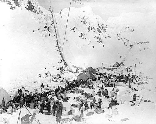
Klondikers at The Scales preparing to ascend Chilkoot Pass, note the tram towers and cables. March, 1898.
University of Washington Libraries, Special Collections [HEG368]
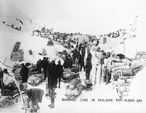
Klondikers waiting in line for customs, Chilkoot Pass, Alaska, ca. 1898.
Photographer Eric A. Hegg. University of Washington Libraries, Special Collections [HEG 629]
The seriousness of the work at hand was now apparent. Our picturesque retinue of children and dogs was left in camp to await the return of the Indians, and having had breakfast at eight o’clock, the seven Indians and ourselves began the toilsome climb upward. The Indians, struggling under their heavy loads, stopped for breath every few moments. We four white men had the exasperating task of dragging along the two empty sleds.
“At eleven o’clock we had reached the foot of the last and hardest part of the ascent. From here to the summit is only half a mile, but the angle of the slope is about forty-five degrees, and as we looked up that long trough of glistening ice and hard-crusted snow, as steep as the roof of a house, there was not one of us that did not dread the remainder of the day’s work. As soon as the Indians ascertained that the crust of the snow was hard and unyielding they divided the packs, leaving nearly half of their loads at the foot of the ascent, intending to make a second trip for them. The two women who had accompanied us thus far now returned to Sheep Camp, and one of the men, producing a strong plaited line of rawhide, about one hundred feet long, which he had brought with him, passed it under every man’s belt, lashing the nine of us together about ten feet apart. The man at the head of the line carried in his hands one of our hatchets, and as we advanced cut footholds in the ice and hard-packed snow. The slope being too steep for direct ascent, we resorted to ‘zig-zagging’—that is, moving obliquely across the bottom of the trough for about sixty feet and then turning at right angles in the opposite direction. Our progress was painfully slow, as every step had to be cut. There was no use in stopping, as there was no opportunity to stretch one’s limbs and nothing to sit down on, so that we kept pegging away, and the hours seemed endless before we stood on the narrow crest of snow that divides the valley of the Yukon from the sea. It was six and a half hours since we had left Sheep Camp, and three since we had lashed ourselves together at the foot of the last ascent.”
Within a few years, as the rush to the Klondike assumed major proportions, the steps cut into the snow and ice of Chilkoot Pass would become known as the “Golden Stairs,” and men would proceed up in lockstep fashion, a image which might be utterly unbelievable if not for the photographs proving it so. Four miles below the summit, Sheep Camp would become a haphazard tent town of more than a thousand souls, with fifteen hotels, innumerable eating places, and even a hospital to tend those wounded on the trail.
Far below, at tidewater, the boomtown of Dyea grew up around the Healy & Wilson trading post in the fall of 1897, as word of the Klondike gold strike brought increasing numbers of people north. The National Park Service website describes the growth of Dyea: “As late as September 1897, Dyea was still nothing more than the Wilson & Healy trading post, a few saloons, the Tlingit encampment, and a motley assemblage of tents. In October, speculators mapped out a townsite, but Dyea’s biggest growth did not begin until the Yukon River system began to freeze up and the winter storms slowed traffic on the Chilkoot Trail. Without the ability to dash up the trails, people began spending more time in Dyea and it became more town-like.”
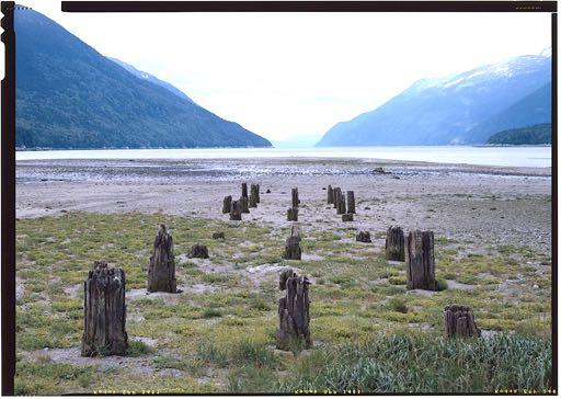
Remaining posts at Dyea Dock looking south towards Taiya Inlet, 1968.
Photograph by Jet Lowe for the Historic American Engineering Record (Library of Congress HAER AK-38)
A long wharf, almost two miles in length, was begun in 1897, shortly after the platting of the townsite, by promoter L. D. Kinney. The wharf was 50 feet wide, 4,000 feet long, and extended from low tide to deep water, being 34 feet deep at the shore end and 60 feet deep at the outer end, with pilings driven 25 to 50 feet into solid ground. Completed in May 1898, the great wharf extended almost two miles across the mud flats and into deep water, and connected to Broadway which led directly into town.
During the winter of 1897-1898, Dyea grew until the downtown area was about five blocks wide and eight blocks long. At the height of its prosperity the town boasted over 150 businesses, mostly restaurants, hotels, supply houses, and saloons. There were also doctors, a dentist, attorneys, bankers, photographers, realtors, two newspapers, two telephone companies, a volunteer fire department, two hospitals and three undertakers, who were pressed into service when a devastating avalanche roared across the trail on Palm Sunday, April 3, 1898, killing over 70 people.
By 1898 three aerial tramways were erected to haul goods over the most difficult sections of the trail, but a year later the White Pass and Yukon Railway had been completed between Skagway and Bennett, the railway purchased the tramway equipment and had it removed, and by the fall of 1899 the Alaska Mining Record reported there was not a restaurant or hotel to be found on the Chilkoot Trail. Fires, the elements, and the flooding of the Taiya River in the 1940s and ‘50s destroyed most of the remaining structures.
The Klondike Gold Rush National Historical Park was created in 1976, a four unit park comprised of the Dyea and Chilkoot, Skagway, and White Pass units in Alaska; and the Seattle unit in Washington state, memorializing the historical period during the Gold Rush. The site of the town of Dyea and the route of the Chilkoot Trail were designated as National Historic Landmarks in 1978, officially recognized by the United States government for their national historical significance. ~•~
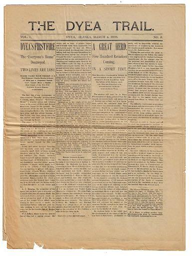
The Dyea Trail, March 4, 1898
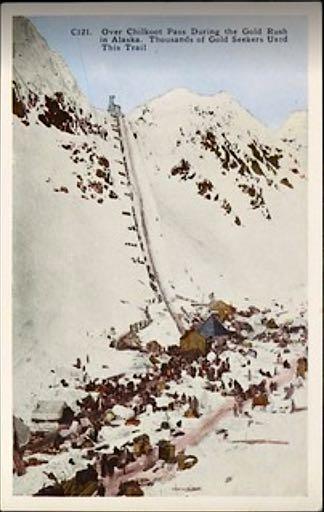
A postcard, the ‘Golden Stairs’


