
6 minute read
St. Michael


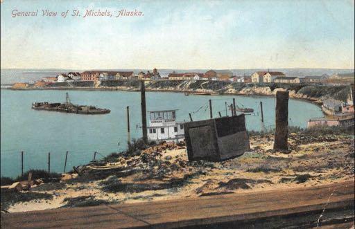
Postcard with caption “General view of St. Michels, Alaska” Note the spelling, one of several variations.
Gateway to the Yukon and the Kuskokwim
Advertisement
Treeless, windswept, boggy St. Michael Island, 8 miles wide and 36 miles long and separated from the mainland by the North Branch of Big St. Michael Canal, lies along the southern coast of Norton Sound, off the Bering Sea, 125 southeast of Nome and some 48 miles southwest of Unalakleet. Adjacent to the southeast part of the island lies St. Michael Bay, the closest deepwater port to the mouth of the Yukon River, approximately 40 miles to the southwest.
This port, protected from the harsh weather of the open sea, became an important stop in the all-water route from Seattle, San Francisco, and other ports on the west coast to the Klondike and Fortymile gold fields via the Yukon River. For those who did not care to face the harrowing challenges of the notorious Chilkoot Pass and a wild trip down the lakes and rivers to Whitehorse and Dawson City, the St. Michael route offered an easier and more convenient, although much longer, trip.

The Russian redoubt (fortified trading post) at St. Michael, circa 1843. [From A Russian Scientific Expedition to California and Alaska, 1939-1849: The Drawings of I. G. Voznesenskii, Oregon Historical Quarterly, Vol. 73, No. 2]
Historically, the first non-native settlement was St. Michael Redoubt, a fortified trading and supply post established by the Russian-American Company in 1833, at the location of what is now the city of St. Michael. The fort, established by order of Ferdinand Wrangel for trading with the Yu’pik people of the area, would later be used as a logistics point for the exploration of southwestern Alaska and the Alaskan interior via the Yukon and other rivers.
In his 1870 book, "Alaska and Its Resources," scientific explorer William Healey Dall described the redoubt: “It is built of spruce logs, brought by the sea from the mouths of the Yukon and Kuskokwim, which annually discharge immense quantities of driftwood. This is stacked up by the Russians in the fall, for miles along the coast north and south of the Redoubt, and is carried in winter to the fort over the ice by means of dogs and sleds. No other fuel exists on the island and adjoining shores. These are entirely destitute of wood, if we except low, scrubby willows and alders, which are found in the vicinity of water.”
When the Russians left Alaska after the territory’s purchase by the United States in 1867, the Alaska Commerical Company took over the operations, but several of the Russian post's traders stayed behind, as St. Michael remained a popular trading post for Eskimos to trade their goods for supplies. William Dall’s very detailed 1870 description continues: “The fort is composed of log buildings with plank roofs, placed in the form of a square, and with the intervals filled by a palisade about ten feet high, surmounted by a chevaux-de-frise of pointed stakes. This is continued round the eaves of the buildings. There are two outlying bastions, pierced for cannon and musketry, and containing a number of pieces of artillery of very small calibre and mostly very old-fashioned and rusty, except two fine brass howitzers of more modern manufacture. The principal buildings are the commander’s house,—consisting of two private rooms, an armory and a counting-room, or contorum,—a couple of buildings used as storehouses, a bath-house, and separate houses for married and unmarried workmen. There is a flagstaff leaning apologetically as if consciously out of place, and a gallery for the watchman, who is on duty day and night, with reliefs, who tolls a bell on the hour to notify the inmates that he is not asleep.”
Dall’s description of the redoubt, inhabitants, and daily life at the trading post is available online at the Internet Archive: https://archive.org/details/1870alaskaitsres00dalluoft
The first prospectors reportedly arrived at St. Michael aboard the steamship Dora in 1880. As river traffic increased with the discoveries of gold in Alaska and the Yukon, St. Michael became the transfer point for passengers and freight from ocean-going ships to the shallowdrafted steamboats which could ply the Yukon and Kuskokwim Rivers. As demand for the smaller boats grew, St. Michael also became a construction center for river steamers. Private enterprises flourished with the river traffic, with one hotel, Healey’s, reportedly designed to accommodate 500 guests, and estimates of people wintering at St. Michael while awaiting transportation to or from the goldfields ran as high as 10,000.

St. Michael, 1901, showing the Russian blockhouse, made of wood, from the original Redoubt St. Michael, 1844.
from the U. S. National Archives and Records Administration (NARA)
The United States established a weather station at the site sometime around 1874, a government school in 1885, and at some point before 1893 a post office; the only U. S. post office—other than the one at Circle City—between Dawson City and the Bering Straits.
In 1897 a United States military post, Fort St. Michael, was established. General Order 59, issued by the War Department on October 20, 1897, declared St. Michael Island and all land within 100 miles of the flagstaff a military reservation. The fort was surveyed the following year, and its buildings constructed, a complex of yellow and white frame buildings, including barracks, an armory, a jail, and several warehouses sporting metal siding. Along the waterfront a quartermaster’s depot and shipyard, and on the eastern tip of the island were the Washington-Alaska Military Cable and Telegraph System (WAMCATS) station and the post cemetery.
When the War Department created the Department of Alaska on January 19, 1900, Fort St. Michael was selected to be the headquarters. Along with Fort Egbert, at Eagle, near the eastern extent of the Yukon River in Alaska, Fort St. Michael was initially thought to be sufficient to establish and maintain order along the Yukon River.
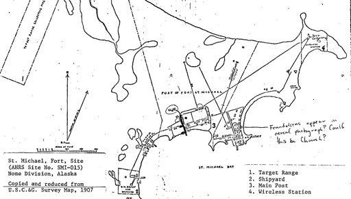
Fort St. Michael, from a U. S. Coastal & Geodetic Survey map, 1907.
Fort St. Michael was the western terminus of the WAMCATS communications system, constructed by the U. S. Army Signal Corps between 1900 and 1904. When the telegraph system was replace by radio transmissions the primary reason to maintain the fort was gone, and when the Alaska Railroad was completed in 1923 the seasonal river traffic was replaced by year-round rail service. In 1925 the U. S. Government closed the fort. In 1929 the fourteen bodies buried in the fort cemetery were moved to the National Cemetery in Sitka, and in 1930 the Customs House at St. Michael was closed. When surveyed for the U. S. Department of the Interior in 1976, only three buildings remained of the once extensive installation; the surviving elements of the Russian redoubt and the U. S. Army fort were separately listed on the National Register of Historic Sites in 1977.

Group of people standing in front of the Northern Commercial Company retail store and office, circa 1903.
A harsh but tempered description of St. Michael is included in John P. Clum’s 1899 report titled 'A Trip to the Klondike:' “A permanent residence at St. Michaels is not a thing to be desired, particularly by persons of sociable disposition, for the winters are long and dark and cold, for hundreds of miles in every direction the waters are locked in their fetters of ice, and from September until the following June the residents of this little island are almost absolutely cut off from communications with the outside world. There is little opportunity for divertisement beyond reading and the occasional hunt with dog teams along the coast or toward the interior. The summer season, however, is delightful, and the scenes and experiences at St. Michael will afford many fascinating memories to those tourists who are fortunate enough to pass theis way during the open season. The nearness of this locality to the Arctic Circle gives a maximum of sunshine and a minimum of twilight during June, July, and August. Although the island is entirely devoid of forests, the formation is rugged and broken, giving a mountainous effect to the general outline, and at twilight the sun tints upon the clouds and sea and landscape are often exquisite beyond description.” ~•~


