6 minute read
6.1 Aoraki/Mt Cook National Park (& context


The journey to Haupapa/Tasman Glacier incorporates the whole Aoraki/Mt. Cook National Park and the road up to it. A curated progression up Mount Cook Road and through the glacial valley of the Park gives the visitor the opportunity to shift states, slow down, and gain awareness prior to being confronted with the glacier itself. The journey is meant to facilitate a sense of ‘purpose, focus, and purity of mind’, and gain concentration towards the story of the glacier and glacial landscape. If the visitor can begin the walking route, Haupapa Tribute Trail, with concentrated presence, perhaps they can experience the trail completely and arrive in melancholic contemplation.
*Note: the design guidelines are referenced below each section to clarify where they were incorporated into the design.
Advertisement
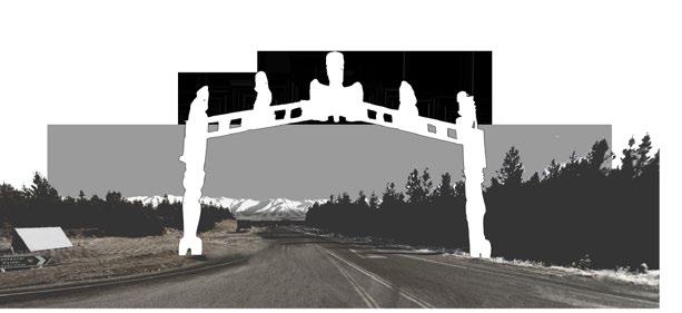
6.1.1 THE JOURNEY TO HAUPAPA Marked beginning The journey starts at the turn-off from Highway 80 onto Mount Cook Road, because this approximately lines up with the farthest historical extent of Haupapa (now Lake Pukaki), and therefore the beginning of the glacier narrative. At the turn-off, one leaves the everyday and enters into the otherworldly glacial landscape. N
The spatial shift is marked in two ways. A gateway in the form of a pouwhenua (land post) is the primary marker into the “otherworld”. A pouwhenua is a carved wooden post used by the Māori to symbolize support and mark a boundary of responsibility (Māori dictionary, n.d.). In addition to marking an otherworldly space, it embodies the aesthetic properties of awareness and familiarity. By connecting to the Māori culture and the creation story of Aoraki and Haupapa, the pouwhenua positions the glacier retreat narrative within the identifiable narratives of Aotearoa/ New Zealand. It connects the area to its history and signifies the responsibility of those that enter to be stewards of the landscape. The idea emerged from a discussion with an expert about Māori culture (Lloyd carpenter, personal communication, September 26, 2019). The design has to be made by a member of the Ngāi Tahu iwi, so the pouwhenua in Figure 6-3 is a place-holder.
The second marker is just beyond the pouwhenua, where the “modal shift” begins. Shortly after the turn-off, there should be a space for individual vehicle owners to leave their cars and take a shuttle into the park. By leaving the normal mode of transport behind, the space is also designated as other.
Applied design guideline(s): I.
Figure 6-3. (below) “Marked beginning” at the turn-off onto Mt. Cook Road.
Modal shift A person needs time to arrive at Haupapa with purposeful concentration. Fast transportation in vehicles undermines the transformational potential of Aoraki/Mt. Cook’s sublime mountain landscape. Although there is not a specific length of exposure time needed for someone to shift into a state of concentration, it seems that the slower one moves, the greater the chance. The traditional notion of a pilgrimage is by foot and can take months. This strategy proposes a shift that counters the contemporary “cult of speed” (Fullagar et al., 2012a, p. 160), but in a way that is accessible to the wide audience of the Park. The journey proposed involves a gradational “modal shift” that begins just after the pouwhenua. The visitor leaves their personal vehicle, into a shuttle, onto a bicycle, and finally on foot at the site. The relatively intimate scale of the Park and its ‘end of the road’ nature offers a suitable environment to explore slower modes of transport. The overall plan (Figure 6-2) illustrates what the modal shift can look like. Personal vehicles and intercity buses stop just after the turn-off, and camper vans can continue just to Glentanner Holiday Park. A shuttle service drops visitors off at various destinations along Mount Cook Road. The D.O.C. Visitor Centre is positioned as the next stop on the shuttle bus route. Here (as well as at Glentanner Holiday Park), visitors can rent bicycles (possibly electric) and continue their journey with a more exposed and free “slowness” than before. By bicycle, the landscape can be felt. It gives visitors the freedom to travel at their own pace to the Haupapa/Tasman Site. The strategy works with the existing infrastructure. It utilizes the road network and only proposes to add a bicycle route from the new visitor centre to the Tasman Valley Road. It also suggests modifications to existing nodes of activity and only adds the new visitor centre. The infrastructure will have to be adjusted and the ‘slower transportation modes’ introduced, but the focus remains on the landscape. Learning in the landscape The visitor centre is positioned in the intersection of the glacial valleys. It looks up the Hooker Valley to the north-west, the Haupapa/Tasman Valley to the north-east, and south towards Lake Pukaki. Understanding and “awareness” of landscape processes becomes centralized within the Park, on the way to Haupapa and other attractions. Tranquil moments Reducing traffic and congestion are by-products of the “modal shift”, but important contributors to creating a sense of “solemn tranquillity” in the National Park. Pedestrians and cyclists will not be pushed to the road’s edges and less noise will make natural sounds more audible. Helicopter noise remains a challenge, but I suggest that D.O.C. applies the “golden hour stillness” guideline in honour of Haupapa. It presents a precise and recurring responsibility; concessioners can contribute to the Park experience in a finite and clear way whilst not impeding business. Additionally, visitors should be informed of the daily ritual and understand why it has been put in place. Design offshoots Supplementary ideas that emerged from the modal shift included the decision to place a grocery store in Mount Cook Village so that visitors do not have to pack so much food. Perhaps it can replace the old visitor centre in the middle of the village. The same logic applies to accommodation; in addition to the camping site, alpine huts can be brought into the valley, so that budget travellers do not have to carry tents. There can also be golf cart rentals for those with limited mobility. As shown in the plan, I echo the Draft Management Plan (2018) by proposing to expand the Park boundary farther south to the edge of Lake Pukaki. This expansion gives the Department of Conservation the authority to carry out the above plans and enables them to better integrate the management of the glacial watershed. Applied design guideline(s): IV. Applied design guideline(s): II. Applied design guideline(s): III. N
0 visitor centre added alpine huts grocery store bicycle rental golfcart rental campsite expansion campervan parking Intercity bus stop shuttle bus stop park & ride marked entrance N


