GIS BASICS
Michael J. Gilbrook, PhD, GISP, AICP

APA FL Orlando Metro Chapter
Planning Academy 101
Ocoee Lakeshore Center, 7 June 2024


Definition of GIS


Functions of GIS


(Charts & Tables)


(Maps)


Common GIS Software Platforms

Commercial software
Enterprise or per -seat license
Annual maintenance fee
Esri Technical Support
Desktop, server & mobile

Open-source software
Free to download and use
Support via user community
Desktop, server & mobile
Two Primary Types of Spatial Data


Points


06/07/2024


Vector Attribute Data Table


Raster Attribute Data Model
Rectangular array of cells
Each cell given a numerical value
Interpretation of cell values depends on the type of raster:
Brightness – Photograph
Elevation – Terrain model
Vegetation – Land cover
Legend
Mixed conifer
Douglas fir
Oak savannah
Grassland
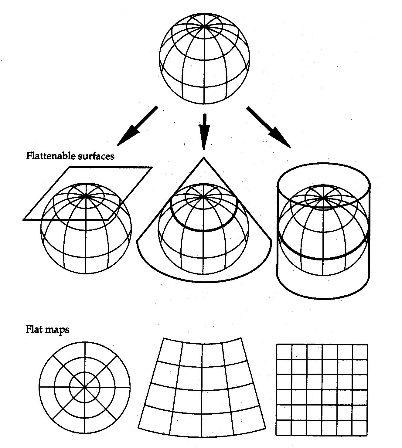
Map Projections (Coordinate Systems)
Map Projections are mathematical operations to make parts of the globe flat.
Map projections chosen to optimize the map for:
Correct area
Correct distance
Correct shape
Navigation bearing (direction)
State Plane Coordinate System is usually best for local government mapping
Florida State Plane Coordinate System
Current 3 Zones: North East West
Zones follow county boundaries
Projections optimized for each zone
Map units are in feet by default
SPCS 2022 will have only 2 zones for Florida: Peninsula West

Online Data Resources
Florida Geographic Data Library
https://fgdl.org/
ArcGIS Living Atlas of the World
https://livingatlas.arcgis.com
ArcGIS Online
https://www.arcgis.com
The National Map (USGS)
https://www.usgs.gov/programs/nati
onal-geospatial-program/nationalmap
City & County GIS web sites
Non-Governmental Organizations


Using ArcGIS Online
HANDS-ON GIS DEMONSTRATION

Navigate to “APA Planning 101” Group


Open Map Viewer Classic


Liquor Store School Distance Compliance


Liquor Store School Distance Compliance


Rezoning Adjacent Property Notification


Rezoning Adjacent Property Notification


Rezoning Adjacent Property Notification


Rezoning Adjacent Property Notification


Rezoning Adjacent Property Notification


Fire Station Response Time Analysis


Fire Station Response Time Analysis


Fire Station Response Time Analysis