ARATHI RADEESH
JUNIOR ARCHITECT

An individual with a passion for architecture and keen insight towards urban spaces and living development with excellent communication skills, and can fit as a team player in a driven environment. An observer with eyes to find solution to the current urban issues linking to the architectural background in the professional world.
+44 7770526821/ +971503972236
arathiradeesh98@gmail.com
Arathi Radeesh
200 Pentoville Rd, London, UK
Reference:
1. Ashok G Iyer
HOD - School of Design & Architecture Manipal Academy of Higher Education,Dubai ashok_iyer@manipaldubai.com
2. Ritesh Jamaiyar
Associate Architect & Director John R Harris & Partners rj@johnrharris.com
ACADEMICS
MSC.URBAN DESIGN & CITY PLANNING
University College London, United Kingdom
BACHELOR OF ARCHITECTURE
Manipal Academy of Higher Education, Dubai
EXPERIENCE
EXPO 2020
Architectural Intern - Real Estate & Development, Dubai
EXPO 2020
Architectural Intern - Real Estate & Development, Dubai
ATELIER ARAMPATHAN, DUBAI Junior Architect
JOHN R HARRIS & PARTNERS, DUBAI Architectural Intern
JOHN R HARRIS & PARTNERS, DUBAI Graduate Intern
JOHN R HARRIS & PARTNERS, DUBAI
Junior Architect
MANIPAL ACADEMY OF HIGHER EDUCATION, DUBAI Research Assistant
ACHIEVEMENTS
• Represented UAE at International Stage of Multi Comfort by Saint Gobain - Milan Italy
• Saint Gobain Multicomfort Contest 2019- National LevelFirst Position
• Participated in Expo Live University Innovation Programme
• Participated in ADPI Ingenierie Airport Process Innovation Challenge
• Active member of Student Council and Event orgnizer in Univeristy
RESEARCH PAPER
• Transforming Mina Rashid to Mixed Used development
• Redefining Neighborhood Community spaces in Karama & Satwa
• Significance of Culture and Heritage in the Urban planning and development
CERTIFICATES
• Greening the Economy: Sustianable Cities
• Monetary Policy in the Asia Pacific
• Sustainable Tourism - Promoting environmental Public health
• Smart Cities - Managment of Smart Urban Infrastructures
• Urban Nature : Connecting Cities, Nature and Innovation
• Reclaiming the street for livable urban spaces
• Beyond Sustainable Development Goals (SDG’s)
• Volunteer at Beat Diabetes Walk - Dubai Cares
• Volunteer at Career Development Center
09/2023 - 09/2024
LANGUAGE
06/2016 - 06/2021
07/2018 -08/2018
07/2019 - 08/2019
SOFTWARE SKILLS


INTEREST




SOUTH POPLAR MASTERPLAN DEVELOPMENT 01
SUBJECT : DENSITY AND FORM YEAR : 2023
TEAM: OSCAR BAYLEY, ARATHI RADEESH, ZHOU ZHOU GE, EMMA ITU, JUAN ALBERTO BONILLA SANCHEZ, AMANE RYOMURA
PROJECT: ACADEMIC (POSTGRADUATE)


Vision Statement: Bringing back the high streets to help South Poplar blossom into a vibrant, connected, and diverse community
A masterplan development within the South Poplar context to accommodate high density mixed used development, providing adequate residential and urban spaces that restitch the urban fabric of poplar and Canary Wharf along the Aspen way. The team focus on the vision to Bringing back the high streets to help South Poplar blossom into a vibrant, connected and diverse community.
CONTRIBUTIONS:
• Initial concept sketches and master plan drafts addressing the key concerns and challenges within the site context.
• Detail study and site analysis about the existing urban layers and proposals to improve better connectivity to accommodate maximum density in South Poplar, London.
• Assistive role in Rhino software to create building blocks and articulate the rendered views that can give a narrative about the project.
BUILDING TYPOLOGY
The Master Plan proposes 3,079 housing units distributed across three versatile building typologies: slab, courtyard, and podium. These flexible designs, as depicted in the master plan, adapt to site-specific needs while accommodating a mix of residential units, retail, and community amenities. This approach ensures efficient and sustainable site optimization while maintaining the character and integrity of the surrounding residential neighbourhoods in Poplar.


- CONCEPT
Developed through six drafts and extensive community input, the masterplan meticulously prioritizes density, connectivity, and integration. The strategic allocation of green spaces along Aspen Way not only enhances livability but also fosters community pride. Furthermore, the inclusion of pedestrian bridges and integrated communal facilities adds vibrancy and cohesion to the project, ensuring a significant positive impact on the surrounding area.


SITE SECTION (AERIAL VIEW)
Building heights have been designed according to a step-down approach, gradually decreasing from the tall building cluster of Canary Wharf towards South Poplar with its low-rise characteristics. This helps to soften the previously stark contrast between the places and allows South Poplar to respond to the heights set out by Canary Wharf in a fluid manner that allows both places to retain their character whilst coexisting in a more integrated way.

view showcases the
plan’s
on strong
and
and
patterns. A

 The aerial
master
focus
connections
visual harmony, aligning with sun
wind
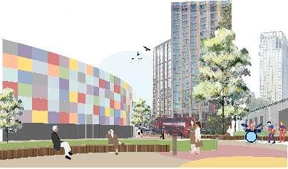
step-down design maximizes views and daylight access. Connectivity across Aspen Way integrates with Canary Wharf and South Poplar’s street network, while a proposed high street fosters social interaction through diverse commercial and retail offerings. Three pedestrian bridges enhance connectivity from the waterfront to Poplar High Street.
HIGH STREET
WATERFRONT PLAZA
WATERFRONT DEVELOPMENT


ACCESSIBILITY
Enhancing pedestrian access along the wharf edge invites individuals from Poplar and Canary Wharf to converge, fostering social interactions and enjoying scenic views. Wide pedestrian walkways integrated with landscaping between linear block typologies create inviting waterfront spaces. Additionally, incorporating canoeing facilities encourages public utilization of the water body, enhancing the area’s social vibrancy along the waterfront parallel to the high street. USES
The waterfront will boast varied hard scape designs, offering scenic views and relaxation spots. Urban furniture will complement dining and retail areas. An urban square will host outdoor markets and local performances, while a stepped landscape feature can double as an amphitheatre. These spaces will foster community and attract visitors from both sides of Aspen Way.
REVITALIZING LEWISHAM 02
SUBJECT : URBAN DESIGN PLACE MAKING YEAR : 2023
TEAM LULWA, ARATHI, NANDISH, EWA
PROJECT: ACADEMIC (POSTGRADUATE)

Vision: Creating a vibrant public realm enhancing the quality of life and attractiveness of the community
Lewisham is one of the opportunity areas of London, with the potential to redevelop public spaces that can create opportunities for social interaction and promote to the sustainable development along the natural features. This project was a group project of four members that worked collaboratively to create a concept design which can be implemented in the borough. The project demonstrated is an extract from the whole document generated.
CONTRIBUTIONS:
• Drawing sketches, preparing opportunity and constraints map, graphic work.
• Identifying issues and bringing up with relevant solutions.
• Green corridor creation and its respective renders.
• Overall strategic ideas and 3D model along with master plan rendering.

LEWISHAM AS A NEW DESTINATION
FOR THE COMMUNITY
Lewisham employs a mixed-use development model, with residential clusters on the periphery and central focus on primary activities. Social rented accommodation in Lewisham Central stands at 24.8%, slightly lower than the borough’s average of 31.1%. Private rented accommodation constitutes 40.6% of households, followed by owned residences at 29.1%. Household composition reveals 42.6% one-person households and 42.1% families. The Lewisham Gateway project drives mixed-use development, including an educational facility for local children.




REGENERATING RETAIL WITH URBAN SQUARE


ENABLING SEATING AND CO-WORKING SPACES

SOCIAL AND COMMUNITY - ACTIVE FRONTAGES
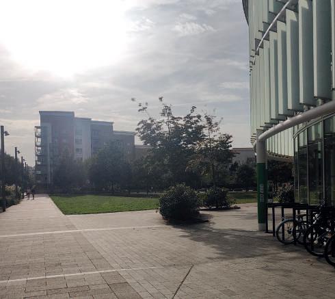
With the concept of Play, Exhibit, Relax and Business, active place making in Lewisham can take place. Re imagining the underutilised spaces as opportunity to cater the community and invite people to use for social interaction and environmental sustainability.


CIRCULAR ECOSYSTEM 03

SUBJECT : SUSTAINABLE DESIGN FOR FUTURE YEAR : 2023 TEAM: INDIVIDUAL PROJECT PROJECT: ACADEMIC (POSTGRADUATE)


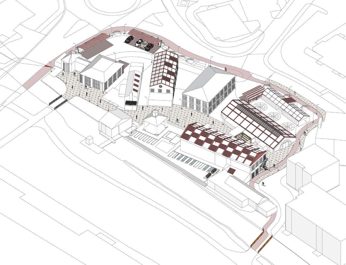
Merton Abbey Mills will be a new destination where people will have a community garden producing local food sources, a marketplace, space for waste treatment and innovation, and co-working spaces that promote social interaction. This destination would have a low carbon footprint, encouraging people to use micro-mobility and promoting electric car-sharing schemes. The energy required for the abbey mills to function would be obtained through the circular process implemented through waste and the movement of people and other natural elements. The vision of the project is to create an ecosystem that is circular to the neighbourhood and, in return, helps reduce the carbon footprint.




• Campaign about sustainable change in the neighbourhood
• Training programs for residents and local businesses indicate benefits.
• Shift of activities and stage 1retrofitting(immediate)
• Fundraising Initiatives.

• Stage 02 retrofitting (more active buildings) and removing temporary structures.
• Introduction of biodomes and collection hubs.
• Introduction of SUDS and community garden.
• The Local Council will be involved in funding and other support.

• Local council approval and support for implementation of strategies.
• Innovation Hub provides job opportunities and co-working spaces within the community.
• Enhancing the walkway with energy-producing tiles and infrastructure for parking.
• Expansion of community garden providing local produce and change in lifestyle habits.


MINA RASHID WATERFRONT DEVELOPMENT 04
SUBJECT : THESIS - II (UNDERGRADUATE THESIS PROJECT) YEAR : 2020 - SEM 7
TEAM/TUTORS: ASHOK.G.IYER (HEAD OF DEPARTMENT),SHAGHI SASI NAIR(ASSISTANT PROFESSOR), KAIRMEIN DEBOO ( THESIS MENTOR/ PROFESSOR) PROJECT: ACADEMIC

• To analyze and understand the key issues faced at an urban scale and prepare a dissertation document as a part of the bachelors degree.
• To analyse and understand port city developments at a global context.
• Conduct a site analysis and interact with the neighborhood residents to understand the major issues faced by the citizens and resolve them through the proposal.
• Prepare a SWOT analysis, zoning layout, proposed masterplan and detailing of architectural desgin for public plaza and cluster of residential apartments focusing on the community development.
The project is an undergraduate thesis project based on the dissertation research prepared for the Bachelors of Architecture. A proposal for masterplan development in the first sea port in the city of Dubai with neighborhood considerations.


PROPOSED GREEN SPACES


THIRDFLOOR

SECONDFLOOR

A conceptual render showing the interaction within the residential clusters, promoting social interaction and live-work enivronment which lacks in the existing neighborhood(Burdubai).
FIRSTFLOOR
Conceptual sketches analysing and understanding community spaces with cluster development.
Community residence is designed with facilities allowing social and diverse interaction. These residences have a combination of live-work units and regular residential apartments. Activities incorporated among every cluster, i.e. societal farming, tot lots, and discussion pods. The community library is designed for all age groups to interact. It includes facilities ranging from a librarian desk to a terrace garden along th waterfront inviting the public to use.


The project has a community plaza connected with the community park that allows the residence and the public to interact and enhance the community activities. The facilities range from Community Park, Clinic, Library, Nursery, Grocery, Recreation Room, F&B along the water edge. The plaza also has an amphitheater that houses Dubai’s street performances and calendared events. Interactive social seating is designed with a solar-powered urban plug at intervals, allowing people to work in public spaces.
MICRO - CLIMATIC SHADING DE-REVIVAL OF BURDUBAI URBAN DESIGN STUDIO
SUBJECT : URBAN CONTEXT STUDIO YEAR : 2020 - SEM 7
TEAM/TUTORS: ASHOK.G.IYER (HEAD OF DEPARTMENT) , KAIRMEIN DEBOO ( GUEST PROFESSOR)
PROJECT: ACADEMIC

• To understand and document the key issues, building typology, key tourist points and its impact to the entire city of Dubai, culture and heritage factors of the neighborhood.
• Prepare the urban layers and revise them as per the documentation.
• Create physical model as a part of the studio showcasing the masterplan development proposed as a group project.
• Preparation of SWOT analysis, structural plan, and contribution to development of masterplan.
• Propose design elements based on the key issues identified (Indiviual/ Pair work).
The project was done during the studio course work where the old neighborhood of Dubai Burdubai was studied and understanding the exisiting urban fabric and its potential for redvelopment. Indiviual works were done portraying design proposals based on the studies conducted by identifying the key issues.


Early Settlements along the creek


Trade flourished, expartirate population increased
Organic town development along the creek following arab street principles.

LAND USE PATTERN

BUILDING AGE
Commercial activities were in majority creating street markets in BurDubai


MOBILITY NETWORK
Present planning of BurDubai neighborhood
BURDUBAI : OLDEST NEIGHBORHOOD THAT GREW WITH TRADE
The demographics of Burdubai consist of Indians, Pakistanis, Emiratis and other nationalities. Diverse Indian community groups are observed. It has also been observed that there is a change in population density from 2011 to 2016 drastically and a smaller percentage of the people moved out of Burdubai due to the lack of amenities and price hikes. There is a huge population that comes from different neighborhoods of Dubai and Shajrah due to the commercial market and other cultural facilities.


KEY ISSUES

CONGESTION
PROPOSED PEDESTRIAN ROUTE
PROPOSED PEDESTRIAN ROUTE
PROPOSED STREET DEVELOPMENT

LACK OF TRAFFIC MANAGEMENT

DILAPIDATED STRUCTURES

LACK OF LEGIBILITY
Based on the key issues identified, Urban strategies were proposed. One of the key issues was the character and legibility of the street.Five streets were zoned based on their functionality and typology make the neighborhood tourist-friendly and accessible to the inhabitants of the region. The second issue identified was the lack of green/open spaces for public interaction. Pocket parks along primary eateries were proposed in the neighborhood.
PEDESTRIAN WALKWAYTHE TRADITIONAL WALK
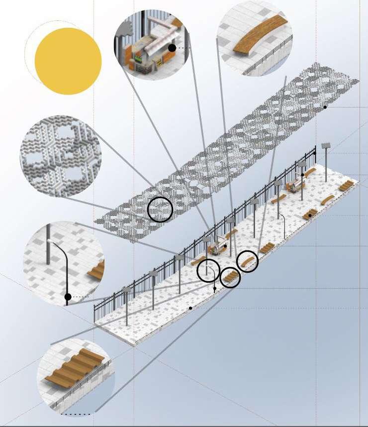
An urban corridor is identified to activate the water edge for public use and connect the heritage landmarks. Redevelopment designs were proposed linking the Marine transport station and Tourist drop off. Shading structures with mashrabiya patterns, contemporary urban furniture, and pedestrian friendlywalkway were proposed.

IDENTIFICATION AND PORPOSAL OF CREEK WALK ROUTE


 AFTER : PROPOSED DESIGN
VIEW OF ELEMENTS OF PROPOSED SHADING
EXISTING CONDITION OF THE CREEK SIDE


LAYOUT
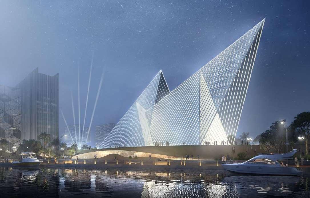

LIFESTYLE CENTER AL AIN, ABUDHABI - UAE 07
FIRM : JOHN.R.HARRIS & PARTNERS YEAR : 2020
TEAM: SUDARSHAN ARAMPATHAN (SENIOR DESIGN ARCHITECT), ANAS ABOOBAKER (SENIOR ARCHITECT), RAJEEV RAMAKRISHNAN (BIM ARCHITECT) AND ARATHI RADEESH (JUNIOR ARCHITECT)
PROJECT: PROFESSIONAL

• To research and study the site and its context.
• To develop a site model based on the context study.
• To document and find reference images suitable for mall and lifestyle center.
• Developing pre-concept design and generating massing with primary elements.
• Assist in development of concept stage design.
• Developing rear elevation according to client comments.
• Generate drawings and model in Revit along with coordination with other consulatants.
The lifestyle center serves for the entire Al Ain community. Hence the spirit of Al Ain has been reflected in the center by studying the community activities and porposed development for placemaking. The aim of the design positively contributes to the public realm along with uplifting the local businesses. The facade has been design welcoming the diverse demographics of the Al Ain city. The planning and facade treatment was kept neutral creating a visual identity and therefore contributing to the attractive skyline.


DENSE VEGETATION DENSE VEGETATION


Different massing explorations were proposed following the contemporary architectural stylingalong with traditional arabic facade treatment. To break the linear form the center has been divided into three block externally yet well connected internally.

Thank you
Contact: +447770526821
Email: arathiradeesh98@gmail.com
Arathi Radeesh