

Journal of Urban Design
ISSN: 1357-4809 (Print) 1469-9664 (Online) Journal homepage: http://www.tandfonline.com/loi/cjud20
Exploring how urban design has sought to inspire confidence and longevity in Western Australia’s Pilbara region
Julian Bolleter
To cite this article: Julian Bolleter (2016): Exploring how urban design has sought to inspire confidence and longevity in Western Australia’s Pilbara region, Journal of Urban Design, DOI: 10.1080/13574809.2016.1247645
To link to this article: http://dx.doi.org/10.1080/13574809.2016.1247645

Published online: 22 Nov 2016.

Submit your article to this journal


View related articles
View Crossmark data

Full Terms & Conditions of access and use can be found at http://www.tandfonline.com/action/journalInformation?journalCode=cjud20
Date: 22 November 2016, At: 17:24
Journal of u rban Design, 2016 http://dx.doi.org/10.1080/13574809.2016.1247645
Exploring how urban design has sought to inspire confidence and longevity in Western Australia’s Pilbara region
Julian Bolleter
faculty of architecture, landscape and Visual arts, australian urban Design research Centre (auDrC), Western australia, australia
ABSTRACT
In the late nineteenth and early twentieth centuries, architecture in mining settlements often acted as a measure of wealth, as if to arouse confidence and longevity in places with an infamously brief lifespan. Arguably, recent planning for upgraded town centres in the Pilbara region of Western Australia has similarly employed urban form to provide reassurance to current and potential future residents of these settlements. Using Karratha, the largest urban centre in the Pilbara, as a case study, this paper explores the ways in which urban form has been used to further a narrative of longevity through references to traditional cities characterized by urban density, spatial delineation and economic diversification. While only six years has elapsed since the launch of a plan to guide Karratha’s transformation from a town into a city, the current mining downturn highlights the limits of urban design interventions in relation to broader issues facing the mining industry. The paper concludes by pointing to the implications of such urban design efforts for the development of cities in Northern Australia.
Introduction
The Western Australian State government-run ‘Pilbara Cities’ policy has funded various projects to upgrade town centres in the mining-dominated Pilbara region of Western Australia (Figure 1). At one level, attempts to recast the structure of these originally Radburn planned towns can be understood as a conventional New Urbanist restructure replete with main streets, traditional European civic spaces and compact urban form. However, it is argued here that beyond this these spatial re-structures also aim to bolster confidence and longevity of these settlements through borrowing from traditional urban contexts ‒ and conversely through symbolically distancing these upgraded town centres from the uncertainties which plagued their original Radburn configurations.
CONTACT Julian bolleter julian.bolleter@uwa.edu.au
© 2016 informa uK limited, trading as Taylor & francis group

Figure 1. Pilbara location plan. Despite its economic might the Pilbara region is sparsely settled; while covering over 506,000 square kilometres just a little over 45,000 people live in the region in a series of small ‘jerry-built’ towns such as Karratha, Port Hedland, newman, onslow, Dampier, and Tom Price. gis data courtesy of geoscience australia.
An overview of the Pilbara
In the 1960s Thomas Price, the Vice President of US-based steel company Kaiser Steel, exclaimed of the Pilbara: ‘I think this is one of the most massive ore bodies in the world … It is just staggering. It is like trying to calculate how much air there is’ (Pincock 2010).
As a result of these deposits the vast Pilbara region has become the economic powerhouse of Australia, representing approximately 5.5% of the nation’s Gross Domestic Product (Green, Newman, and Mitchell 2014) and containing the two highest export tonnage ports in Australia (Newman et al. 2010). Largely as a result of the Pilbara, the past decades have been one of extraordinary economic growth in Australia (Chapman, Tonts, and Plummer 2014). Currently, the Pilbara produces 98% of Australia’s iron ore, and generates approximately $3.5 billion in royalties for the state of Western Australia. This represents 70% of Western Australia’s mineral revenues and approximately 14% of the state’s $25.4 billion budget for 2012/13 (Green, Newman, and Mitchell 2014). While iron ore currently dominates the Pilbara economy, liquid natural gas (LNG) is an increasingly significant component of the region’s economic output (Chapman, Tonts, and Plummer 2014).
Despite its economic might, the Pilbara region is sparsely settled; while covering over 506,000 square kilometres just a little over 45,000 people live in the region (Newman et al. 2010) in a series of small ‘jerry-built’ towns such as Karratha, Port Hedland, Newman, Onslow, Dampier and Tom Price (Bolleter and Weller 2013) (Figure 1). This low population density can be partly explained by the region’s hot and dry climate, the failure of its rugged and arid
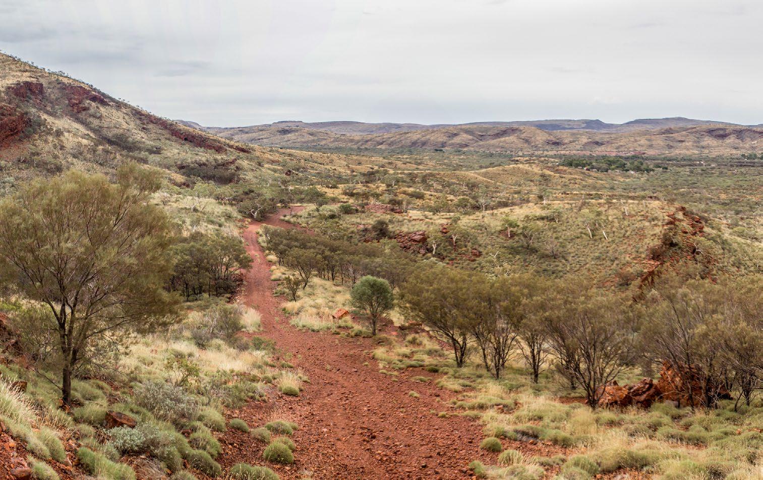
Figure 2. Pilbara landscape. The Pilbara’s low population density can be partly explained by the region’s hot and dry climate, the failure of its rugged and arid landscape to be utilized from agriculture to any large extent, and its remoteness. image courtesy of robyn Jay (https://www.flickr.com/photos/ learnscope/15091553096/)
landscape to be utilized from agriculture to any large extent and its remoteness (Figure 2). As Eric Sheppard (2013, 269) explains: ‘in societal terms the Pilbara can be considered as the periphery of the periphery ‒ the Australian tyranny of distance cubed …’.
Indeed, the Montebello Islands, just over 100 kilometres from Karratha, were considered remote enough in 1957 to be selected as the site for Britain’s first atomic bomb test (Sheppard 2013).
The low population of the Pilbara, and requirement for labour in the most recent mining boom, resulted in a transient fly-in fly-out workforce (Creating Communities Australia 2009) which was estimated in 2010 to be approximately 20,000 people (The Planning Group 2010). Indeed, many of the workers employed in the Pilbara resided in Perth, but also as far away as the Gold Coast in Queensland, Bali in Indonesia and even Phuket in Thailand (Aitchison 2015).
The Pilbara Cities policy
Partly in relation to the poor state of regional towns in Western Australia, particularly in the Pilbara, since 2008 a concerted effort has been made by the Western Australian state government to invest 25% of the state’s mining royalties into regional infrastructure and services, a policy known as ‘Royalties for Regions’. While this funding was arguably much needed, the policy has political origins. The substantial new funding was the non-negotiable demand won by the then National party leader (and state Regional Development minister) Brendon Grylls as a condition of his party’s support for the Liberal party in the state’s hung parliament (Australian Associated Press 2008). In essence, the still-operational Royalties for Regions
policy is about counter balancing the concentration of capital generated by resource industries in Perth through spatial redistribution to the regions (Chapman, Tonts, and Plummer 2014), and in particular the Pilbara (Pilbara Development Commission 2016).
One of the key initiatives of the Royalties for Regions scheme is the ‘Pilbara Cities’ vision which was established in 2010. Indeed, by the end of 2017–18 Royalties for Regions is projected to have committed more than $1.7 billion directly to the Pilbara Cities projects (Law 2014). This funding has been directed towards key focus areas which include: infrastructure coordination, land availability and development, community projects and engagement, and economic diversification (Pilbara Development Commission 2016). Furthermore, the Pilbara Cities initiative aims to build the population of Pilbara towns and simultaneously grow them into ‘more attractive, sustainable local communities’ (Pilbara Development Commission 2016).
Karratha
The case study of this paper is the Pilbara city of Karratha, which is the largest settlement in the Pilbara, and the centre of the Pilbara’s LNG processing and handling (Chapman, Tonts, and Plummer 2014). From its gazetting in 1969 as purpose-built workers’ colony, Karratha’s growth has been closely linked with the growth of the resources industry. This reflects the fact that, at the time, mining labour was typically housed near mine sites either in camps or purpose-built company towns (Sheppard 2013). In return for building such communities mining companies received benefits from government in the form of lower rates and taxes (Storey 2001).

Figure 3. Karratha. Karratha’s linear settlement pattern stretches along a vehicular movement spine, which is located between the Karratha Hills and the coast. gis data courtesy of landgate.
Karratha’s linear settlement pattern stretches along a vehicular movement spine which is located between the Karratha Hills and the coast. This linear form consists of six main suburbs running in an east‒west linear pattern over approximately 8 kilometres (Creating Communities Australia 2009) (Figure 3). These suburbs predominantly comprise single lot, low-density residential developments arranged generally in accordance with Radburn planning principles (The Planning Group 2010). The distribution of land uses in Karratha is typically precinct based, with commercial and retail uses focused primarily within the centrally located town centre (The Planning Group 2010).
Karratha ‘city of the north’
The development of Karratha into a ‘city of the north’ as part of the Pilbara Cities vision was intended to facilitate ‘sustainable growth and development over the long term; support economic activity and promote diversification; enhance the quality of life for existing and future residents; deliver a vibrant and activated city centre; harmonize with the environment and foster a distinctive sense of place’ (Creating Communities Australia 2010, 3). As Brendon Grylls explained: ‘This watershed plan will establish Karratha as a highly desirable place to live, work and raise a family; a future city with facilities on par with other major cities of Australia …’ (Mills 2010a).
In line with this transition of Karratha from a mining town into a ‘major regional city’ is a projected population increase of up to 50,000 people (Mills 2010a), an increase of over 300% from the current population.
Research structure
Brendon Grylls refers to the fact that Karratha’s recent planning has been in part deployed to change the ‘psychology of the Pilbara as a place to live rather than a place to work’ (Law 2014). In order to explore how urban design has been employed to shift this psychology, this paper is structured by a principle research hypothesis:
That the recent proposal for revitalizing Karratha’s town centre has employed urban form as an measure of permanence, so as to instil confidence and longevity in a mining settlement which otherwise may have a short lifespan.
The research method that this paper adopts to test this hypothesis is an interpretive critique (Swaffield and Deming 2010) which seeks to reveal new understandings and perspectives upon Karratha’s urban design, and hence provide insight into what such interventions may be trying to achieve at a deeper level. The hypothesis is tested through an analysis of urban design propositions in Karratha which seeks to better understand the messages these propositions may communicate, and how these messages may further add to a sense of longevity.
In order to address these questions, this paper is structured into three main sections. The first of these provides an account of the current Radburn-derived urban form in Karratha and how it generally undermines confidence in Karratha from a perspective of longevity. The second explores in spatial terms the principle urban design gestures involved in the de-Radburnization of Karratha’s town centre and how these gestures seek to inspire confidence over the longer term. The third section discusses the limits of urban design with respect to delivering longevity through analysis of recent demographic and economic data.
Relevance
With the release of the Federal Government’s White Paper for the development of Northern Australia (Australian Government 2015), it is probable that a number of mining towns in this broad region will be attempting to reimagine themselves over the next decade. While these towns are not necessarily configured along Radburn planning principles, this paper could generally help to inform the planning of these towns, particularly where such planning seeks to instil confidence and longevity. As such, this paper is partly directed towards planners and local administrators who may be steering this process. Moreover, Karratha is the primary population centre in the Pilbara, and Karratha’s planning will continue to serve as a reference point for the planning of other Radburn planned towns within the region, many of whom are aspiring to similar goals. Furthermore, this paper will add to the typically scant literature available concerning ‘de-Radburnization’ efforts in Australia. Finally, while there has been significant analysis of the Pilbara from an economic, societal, sustainability and infrastructural perspective (Newman et al. 2010; Green, Newman, and Mitchell 2014), no comprehensive analysis has occurred of the urban form resulting from the Pilbara Cities policy to date. This paper brings scholarly attention to urban design practice which has otherwise largely escaped such scrutiny.
Karratha’s existing urban form
Radburn planning in the Pilbara
The Radburn neighbourhood unit was first developed at the American suburb of Radburn, New Jersey. At Radburn, vehicular and pedestrian traffic was separated by the use of internal landscaped spines that were both open space and pedestrian connections (Freestone, Garnaut, and Iwanicki 2011). In the Pilbara region Radburn planning principles were applied in resource towns such as Dampier (1965), Karratha (1979) and South Hedland (~1980) (Figure 4). Given their remoteness, it was considered these towns needed to be designed to attract and retain a skilled workforce (Freestone, Garnaut, and Iwanicki 2011). As such, planning professionals were sought to create designed and ‘modern’ community settings, such as the Radburn plan, which was perceived would compensate for the ‘isolation’ and the

Figure 4. radburn planning in the Pilbara. in the Pilbara region of Western australia what were then still-experimental radburn planning principles were applied in resource towns such as Dampier (1965), Karratha (1979), and south Hedland (~1980). gis data courtesy of landgate.

Figure 5. The radburn plan of the Karratha suburb of bulgarra is structured by isolated cells of residential development between which run extensive open space systems rather than interconnected street networks. gis data courtesy of landgate.
harshness of the landscape (Freestone, Garnaut, and Iwanicki 2011). Such is the prevalence of Radburn planning principles in the Pilbara that it has been identified as constituting a key aspect of the Pilbara vernacular (Landcorp 2012). Indeed, Pilbara towns collectively contain a higher number of Radburn planned neighbourhoods than Perth (the capital city of Western Australia).
In accordance with Radburn planning principles, Karratha is structured by isolated cells of residential development between which run extensive open space systems rather than interconnected street networks (The Planning Group 2010) (Figure 5). In Karratha these open spaces tend to be drainage corridors which conduit water from the rocky scarp to the south to the ocean in the north. While these drainage corridors provide a generous area of open space ‒ as much as 46% of the total in area in the Karratha suburb of Bulgarra (Stratagen 2012) ‒ they provide little amenity to residents. This is due in part to over-zealous regulations which limit what can be introduced into a drainage corridor and also because the existing low population density does not reach the threshold at which council rates and taxes could be directed towards the redesign and upkeep of these areas at a higher standard.
While the intent of Radburn planning philosophy was to allow permeability between private and public open space, in Karratha property owners have tended to barricade themselves off from the public open spaces, a situation which has resulted in areas which are not well taken care of and are at times unsafe (The Planning Group 2010) (Figure 6). Evidence of this is that in Karratha’s Radburn planned suburbs of Bulgarra and Pegs Creek the most commonly reported crime is assault (Creating Communities Australia 2009).

Figure 6. Karratha drainage reserve. in Karratha property owners have tended to barricade themselves off from the public open spaces – a situation which has resulted in areas which are not well overlooked and are at times unsafe.
Due to the priority given in Karratha’s planning to the interconnected internalized public open space system, the existing road network is fragmented into a number of isolated cells of residential development. Limited connections within these cells mean that residents have developed informal routes through the internalized public open space system. Despite these informal routes, formal interconnection between the cells remains non-existent and each cell appears to operate as a separate community, a situation which has resulted in social disparity between residential cells (Stratagen 2012).
The role of Radburn planned urban form in undermining Karratha’s longevity and confidence
While the pattern of people moving to Karratha for the opportunity of economic advancement is familiar, it was not generally regarded as a place to put down roots (Creating Communities Australia 2010). Indeed, as part of 2009 internet survey to ascertain people’s intentions to remain in the Shire of Roebourne (within which Karratha is located), responses showed that 36% of people only intended to stay for up to five years, 13% intended to stay between six to nine years, 29% intended to stay more than 10 years and 22% were unsure of their intentions (Creating Communities Australia 2009). Evidence of uncertainty about Karratha’s longevity can also be found in the lack of graves at the local cemetery, a sign that can be interpreted to mean that many people do not truly see Karratha as home (Creating Communities Australia 2010). The reluctance of Karratha’s residents to make Karratha a longterm home relates to a myriad of factors which are much broader than those pertaining to urban form; however, Karratha’s Radburn planning arguably stymies residents making a longer-term commitment to the town.
First, given its comparatively long association with mining settlements in the Pilbara, Radburn planning tends to confirm that such settlements are exclusively about the mining industry, with the exclusion of other potential industries and related workforces. This is particularly the case in Karratha where the town’s urban identity has been inextricably linked with the expansion of the resources industry (Sheppard 2013). Compounding this, the original homes and buildings have generally been constructed cheaply to service a short lifespan (The Planning Group 2010). The ‘drab and bleary’ (Grylls, in Mills 2010b) urban form which results tends to confirm to locals and visitors that Karratha is not a place to dwell over a long period.

Second, Karratha’s Radburn planned centre was structured by an inwardly-focused shopping centre, large carparks and a convoluted road network (Figures 7–9). The result was a town centre drastically lacking legibility. Indeed, as Andrew Watt, Senior Associate Creating Communities, explains, when you drove into Karratha town centre, prior to its revitalization, it was ‘almost indiscernible as to what the actual town centre was’ (Andrew Watt, 5 August 2016, interview with the author ). Arguably, this lack of a defined centre or a ‘heart’ of the town exacerbates a community’s sense of ‘not belonging’. As Kevin Lynch (1960, 4) explained, the provision of legibility is about much more than simple way-finding: ‘let the mishap of disorientation once occur, and the sense of anxiety and even terror that accompanies it reveals to us how closely it is linked to our sense of balance and well-being …’.
Furthermore, a legible urban setting, capable of producing what Lynch refers to as a ‘sharp image’, plays an important social role as well: it can provide the ‘raw material for the symbols and collective memories of group communication’ (Lynch 1960, 4). To Lynch’s way of thinking this lack of legibility arguably inhibits wellbeing at both a personal and societal level.
Moreover, the town centre lacked ‘spaces which can help to integrate a community’ (Creating Communities Australia 2010, 56). For example, Creating Communities Australia (2009) noted that Karratha lacked youth programmes and activities, cultural events and activities. At a more general level, it was perceived that the town centre was not vibrant, accessible or indeed a connected town ‘for all sectors of the community’ (Creating Communities Australia 2009, 41). Arguably, such a lack of social infrastructure stymied the ability for a sense of community to form which could increase the resilience of Karratha to economic uncertainty over the longer term.
Figure 7. Karratha’s original town centre. an aerial view of Karratha’s original town centre viewed from the west image courtesy of Karratha Visitor Centre (http://www.karrathavisitorcentre.com.au/).

Figure 8. Karratha’s original town centre. Karratha’s radburn planned centre was structured by an inwardlyfocused shopping centre, large carparks, and a convoluted road network.

Figure 9. Karratha’s original road network. Due to a convoluted road network the town centre drastically lacked legibility. as andrew Watt explains when you drove into Karratha town centre, prior to its revitalization, it was ‘almost indiscernible as to what the actual town centre was.’
In addition, Karratha’s Radburn planning has tended to exacerbate societal divisions which have been typical of the mining boom period in the Pilbara. As per Radburn planning principles, Karratha is made up of a series of residential ‘cells’. As a result of this disconnection between these cells, social disparities between areas has been exacerbated (Stratagen 2012). Evidence of this is the pockets of dilapidated ageing housing which effectively concentrates and separates the socially disadvantaged from more affluent areas of the community (Stratagen 2012). The overall effect of such societal stratification is the inhibition of a functioning, cohesive community.
Finally, the vast, barren open spaces and drainage reserves resulting from Radburn planning in Karratha also perpetuate a sense of displacement; in some ways these spaces are reminiscent of what Sola Morales referred to as ‘terrain vague’ (Figure 6): ‘limitless spaces … external to the urban system, to power, to activity, constitute both a physical expression of our fear and insecurity and our expectation of the other’ (Sola Morales 1995, 112). While Sola Morales’ definition of ‘terrain vague’ referred to abandoned spaces as opposed to spaces which have been formally planned for, as in the case of Karratha, the effect is not dissimilar. The insecurity precipitated by Karratha’s Radburn generated open spaces is exacerbated by Karratha’s remoteness, the enduring strangeness of the landscape and the underlying indigeneity of such landscapes. Such landscapes perpetuate the feeling that despite two centuries of European Australian occupation ‘we still seem to be struggling to settle Australia …’ (Steve Dovers, in Gleeson 2006, 15). The expectation of ‘the other’ that these spaces evoke is disquieting for residents as relations between homeowners and the Pilbara’s indigenous population typically (but not always) remain estranged. Evidence of this can be found in the nearby town of Roebourne (which can be understood as a ‘shadow’ settlement of Karratha) which has a high indigenous population, societal issues and is notorious for struggles between Aboriginals and police.
The spatial reorganization of Karratha’s town centre
Urban design can be understood generally as a reaction to what has preceded it. Indeed, as Peter Hall (2002, 7) tells us ‘twentieth-century city planning, as an intellectual and professional movement, essentially represents a reaction to the evils of the nineteenth-century city’. Arguably, this dynamic of urban design reacting and ‘correcting’ what has come before is particularly pronounced in Karratha, in a large part because of the relative failure of the Radburn planning ideals in the Pilbara.
The problems of Radburn planning have been well documented in New Urbanism literature (Martin 2004), and Australia has a number of examples where de-Radburnization has been carried out. Such examples have tended to be concentrated in public housing estates on the outskirts of Sydney, such as Macquarie Fields, Bonnyrigg and Minto (Bruce Judd, personal communication with the author 12 June 2013). These efforts tended to divide Radburn-inspired ribbons of internalized public open space into private backyards, or where open space ribbons were retained to thread roads along their edge to ‘correct’ Radburn planning’s inward focus (Martin 2004) and maintain visual surveillance (Judd 2013). Such modifications have generally been accompanied by a reduction in the concentration of public housing (Judd 2013).
The spatial de-Radburnization of Karratha town centre and inspiring longevity
The de-Radburnization efforts encapsulated by Karratha’s recent planning differs from these public housing estate processes in that efforts were generally concentrated on Karratha’s town centre rather than specifically residential precincts. Furthermore, the de-Radburnization efforts in Karratha arguably carry a greater symbolic load as they are of a larger scale and are being used to promote a new ‘city’ rather than what is essentially a retrofitted suburb.
By way of a summary, Karratha’s town centre revitalization1 aimed to create a ‘vibrant commercial heart for a population of 50,000’ (Government of Western Australia 2010), and included planning for medium to high density street fronted mixed use redevelopment, the realignment and traffic calming of a number of the main roads, the creation of new parks and urban spaces, the upgrading of drainage reserves and school grounds, multilevel car park stations, a medium to high-rise resort style hotel and a civic centre around existing civic buildings (Figure 10). In spatial terms, the main urban design gestures included the introduction of urban density, spatial delineation and economic diversification. The following section explores these propositions both spatially and in relation to the symbolism they carry in the Pilbara context.

Figure 10. Planning for the revitalization of Karratha’s town centre by a consultant team lead by The Planning group. Karratha’s town centre revitalization aimed to create a ‘vibrant commercial heart for a population of 50,000’ and included planning for medium to high density street fronted mixed use redevelopment , the realignment and traffic calming of a number of the main roads and the creation of new parks and urban spaces.
Urban density
The urban density that has been recently deployed in Karratha town centre sustains a number of interrelated narratives that relate to this paper: that dense urban form implies permanence, that dense apartment living with resort-style accoutrements taps into the language of Dubai’s urban development (Dubai being a city which is often regarded as having successfully diversified away from primary resource extraction) (Sheppard 2013), and finally that urban density is ‘sustainable’ when compared to suburban form.
In the nineteenth and early twentieth centuries architecture in mining towns often functioned as a barometer of ‘wealth and permanence, as if to inspire confidence and longevity in places with a notoriously short lifespan’ (Aitchison 2015, 275). Arguably, a similar dynamic has been in play in Karratha where the transition from a ‘town’ to a ‘modern vibrant city’ (Law 2014) is symbolized through urban density which is partly deployed to imply permanence. In contrast to the lightweight, ‘lowroofed, drab, and without notable architecture’ (Grylls, in Mills 2010b) which resulted from Radburn era planning, recent urban design projects in Karratha ‒ such as the nine-storey Pelago West tower (Figure 11) ‒ serve as a symbolic commitment by the state government that a long-lived, urban and vibrant city will coalesce around such bold beginnings (Williams 2011).
Arguably, this urban density also represents an attempt to tap into the miraculous ‘Dubai effect’ (Basar 2007). As Eric Sheppard (2013, 273) explains: ‘Dubai can be read as a case study of how an oil economy can produce economic prosperity … through a combination of spectacular real estate developments and (re)positioning itself as a global transport, trading and Islamic finance hub’. Indeed, Premier Barnett, with backing from iron ore magnate Andrew Forrest, went as far as to suggest that the Pilbara Cities vision was modelled on Dubai, as he explained in 2008:

Figure 11. Pelago West development. recent urban design projects in Karratha – such as the nine-storey Pelago West buildings pictured – serve as a symbolic commitment by the state government that a longlived, urban and vibrant city will coalesce around such bold beginnings. image courtesy of Jim bendon. (https://www.flickr.com/photos/jim_bendon_1957/9587312345/)
People go and live in places like Dubai. Talk about a harsh environment, yet thousands of people go there to live because they have a comfortable environment. What we have done in the Pilbara, in a harsh landscape and with a seriously hot summer, is to build replica suburbs of Perth. There is something to learn from Dubai. Maybe we need to build apartments with airconditioning and swimming pools. (Australian Associated Press 2008)
Certainly the Pelago West development has been promoted through its pools and other ‘resort-style’ accoutrements (Williams 2011) which ‘are all part of an attempt to lure people to live and work in the desert’ (Taylor 2015, 6). The fact that projects such as Pelago West directed towards the luxury end of the market, rather than a pragmatic contribution to Karratha in terms of affordable housing provision, is the high purchase prices; in 2011, the developer, Finbar, was selling one-bedroom units for $600,000 and two-bedroom and three bathroom apartments for, on average, $975,000 (Williams 2011).
While on the one hand urban density and luxury are conflated in Karratha, in a broader context density is also often seen to be a vital ingredient of urban sustainability (Farr 2008). In this context the Western Australian state government was intent on avoiding the recreation of ‘urban sprawl’ in Karratha with all its attendant sustainability issues. As Premier Barnett explained, ‘when the Pilbara was developed in the 1960s, the governments and the industries of the day tried to replicate Perth’s suburbs with three bedroom, one bathroom dwellings, backyards, and Hills hoists … (however) a business-as-usual model is no longer the desirable option’ (Newman et al. 2010, 2). In this respect the emerging density of Karratha’s town centre has parallels with the 343 Activity centres which are being planned in Australia’s capital cities. Activity Centres (Bolleter and Weller 2013), the densification of public transport nodes, are generally equated with ‘sustainability’ in that such Transit Oriented Development (TOD) is considered to reduce automobile dependency, energy consumption and carbon dioxide emissions and conserve farmland and natural biodiversity (OECD 2012). In a similar vein, the urban design consultants for the Karratha town centre upgrade stated in their due diligence report that if the Karratha town centre was developed with densities of up to R1002 it could potentially accommodate a population of 50,000, the target population for Karratha in the Pilbara Cities policy, within the existing urban area of Karratha (The Planning Group 2010) and as such avoid further suburban sprawl.
Given that the Pilbara region requires enormous quantities of energy to carry out mining, oil and gas operations, and transport ore to ports (Green, Newman, and Mitchell 2014), and its Greenhouse Gas (GHG) emissions make up approximately one-third of the Western Australian total at 25,000,000 tonnes per annum (Green, Newman, and Mitchell 2014), the deployment of an urban form which evokes, for many observers, urban sustainability acts as a powerful antidote to a mining industry which is anything but sustainable. Moreover, environmental sustainability and economic sustainability are often conflated and in this respect such ‘sustainable’ density perpetuates a sense of confidence in Karratha’s longer term future.
Spatial delineation
In part as a reaction to the lack of legibility of Karratha’s original town centre, much of the planning for Karratha’s town centre was about defining main streets and a town centre (Law 2014) in spatial and psychological terms, respectively. This has been ostensibly achieved through the creation of a new central street, ‘Sharpe Avenue’, which extends from the Dampier Highway (the main point of arrival) in the south right through to the Pelago development and terminating in a public park with playground in the north (Figure 12). Karratha Terrace has also been introduced, an east‒west main street with public transport and safe
pedestrian and cycle environment with traffic calming and at key nodes (Government of Western Australia 2010). Karratha Terrace and Sharpe Avenue form a dramatic contrast with most of Karratha’s inhospitable, wide, vehicular-dominated roads through its regular street tree plantings, relatively pedestrianized nature, incidental shade structures and emerging alfresco dining. The effect of the addition of these streets is an interconnected street grid girding the revitalized town centre.
At one level the creation of such a street grid and identifiable ‘main street’ can be seen to conform to New Urbanist ideology in which ‘interconnected networks of streets should be designed to encourage walking, reduce the number and length of automobile trips, and conserve energy’ (Congress of New Urbanism 2016). However, the new street pattern also arguably has a psychological dimension. For example, the creation of an easily identifiable and ‘imageable’ main street resonates with Lynch’s (1960, 4) explanation that by limiting disorientation we can improve our sense of ‘balance and wellbeing’.
The street grid more generally draws on precedents (albeit at a much larger scale) such as Manhattan where the grid is one vital component of the city’s flexibility and resilience (Koolhaas 1994). The introduction of the grid in Karratha aims to create a structure which is flexible enough to accommodate periods of growth and decline which inevitably will buffer the city. At a deeper level the grid also satisfies a psychological desire for boundedness. Arguably, the Radburn planning structure of Karratha and the resultant vague and unbounded spaces which have resulted have acted to exacerbate this sense of unease. In contrast, the street grid serves to provide a rational ordering of a strange space (Dovey and Sandercock 2005).

Figure 12. introducing a legibility into Karratha’s town centre. in part as a reaction to the lack of legibility of Karratha’s original town centre much of the planning for Karratha’s town centre was about defining main streets and a town centre in spatial and psychological terms respectively.
A microcosm of the boundedness implied by the adoption of a street grid is the creation of variety of public plazas, piazzas and urban streets (Figure 10). Arguably, such spaces have been created in part to normalize Karratha so that its urban spaces resonate with a ‘timeless’ Beaux-Arts planning language and its neatly delineated squares and markets (Gelerntner 1996). The appeal of such landscapes is explained by Catherin Bull (2002):
Although contemporary Australians … are happy to view the bush at a distance, they continue to find its elements and qualities difficult to live with in the day-to-day landscapes of their yards, streets, towns and cities. They rarely welcome its elements as part of the landscapes they have made, believing that these should remain in the wilderness landscapes beyond, to visit, rather than live with. (15)
Certainly the desire to ‘banish the bush’ that Bull refers to is heightened in remote settlements such as Karratha. The intent of introducing neatly delineated, Beaux-Arts-influenced urban spaces is that they will precipitate a societal shift. As Brendon Grylls exhorted: ‘We are looking to set up town squares with a bit of culture and lifestyle not currently associated with those places’ (Mills 2010b). By adopting these configurations in Karratha, an attempt is being made to position Karratha within a suite of long standing European towns and settlements. Furthermore, such spaces ‘normalize’ Karratha’s town centre and bring it into line with what could also be expected to be found in the heart of any of Australia’s capital cities. As Terry Redman (ex-Western Australian Nationals party leader) explained about the dining experience offered by the upgraded Karratha terrace:
Sitting in the coffee shop under the Pelago building, I could have been sitting in Claremont, Nedlands or St George’s Terrace (in Perth) … It gave you the sense that this isn’t just a men’s work camp. (Law 2014)
Economic diversification
There is widespread consensus that the diversification of industry, away from a sole reliance on mining, is a crucial step in ensuring Karratha’s longevity (Green, Newman, and Mitchell 2014). While many aspects of this diversification extend well beyond the remit of urban design, planning for Karratha’s town centre has attempted to deliver a spatial framework which could enable this diversification over time. As Peter Newman et al. explain: when a boom dries up what’s often left is the secondary and tertiary infrastructure. This can be enough to sustain a city, but only if such infrastructure has already been created. (Green, Newman, and Mitchell 2014, 72)
In the revitalization of Karratha town centre this takes the form of designated mixed use retail, commercial, entertainment, accommodation and cultural precincts (Figure 13). The presumption is that a diversity of co-located land uses, deployed at a medium to high density, will stimulate knowledge diffusion and thus economic growth and diversification (OECD 2012). In the retail precinct these aspirations are being embodied in a new project such as ‘The Quarter’ being developed by state government land developer LandCorp. As LandCorp chief executive Frank Marra explained, ‘The Quarter is a much needed asset to the continuing growth of the city centre. This latest precinct is a major boost in growing and diversifying the local economy, providing increased opportunities for existing local operators while also attracting new businesses into the community’ (Doric 2014).
It is at the arts and community precinct that the desire to reshape Karratha’s image as a mining-only centre reaches its zenith. This $40 million precinct will be located near the entrance to the town at the southern end of Sharpe Avenue (Figure 13) and is planned to

Figure 13. Mixed use precincts. in the revitalization of Karratha town centre a number of precincts have been introduced including mixed use retail, commercial, entertainment, accommodation, and arts and community precincts.
include a 450-seat theatre, a new library, rooftop cinema, art gallery, amphitheatre and local history museum (ABC News 2014), all which are aimed at economic diversification and by implication the long-term economic viability of Karratha (Figure 14). As Shire President Peter Long explains about the cultural precinct:
It gives an extra dimension to the town instead of being a dormitory suburb for a mine. When we’ve got a theatre, we’ve got cultural activities and intellectual activities. It just gives us a whole new aspect to the shire and for people to live here. It just makes it a much better place to be. (ABC News 2014)
This project can be understood as a modest version of projects such as Abu Dhabi’s new cultural hub which includes the Guggenheim Abu Dhabi, designed by Frank Gehry, a performing arts centre by Zaha Hadid and the Lourve Abu Dhabi by Jean Nouvel. Such projects aim to rebrand cities which are dependent on the extraction of primary resources as centres of culture (with an attendant increase in longevity). As Marcus Westbury (2008) explains, in this sense:
culture is an aspiration. It is a driver of status, and status is bound to wealth and prestige. Global cities increasingly aspire to cultural prestige for its intangible aura and because they believe it will drive economic growth. (173)
Unsurprisingly, architecture is called on to establish an iconic form for the ‘distinctive’ new Karratha theatre project (Figure 14), the cornerstone of the proposed cultural precinct. The ‘use’ of architecture in this respect can be understood in relation to a situation in which the economic development of cities has come to depend more strongly on the production of

Figure 14. arts and community precinct. it is at the arts and community precinct that the desire to reshape Karratha’s image as a mining-only centre reaches its zenith. This $40 million precinct will be located near the entrance to the town at the southern end of sharpe avenue and is planned to include a 450-seat theatre, a new library, rooftop cinema, art gallery, amphitheatre, and local history museum. image courtesy of JCY architects and urban Designers.
images (Dovey 2005), computer generated and real. Such imagery has become increasingly important in the global economy, as a strategy to attract wealth, in physical and human terms (Marshall 2001). In short, for Karratha to develop an economy which is reliant on more than the export of iron ore and LNG it must send a variety of special signals to the rest of the world, in this case that it is a centre of cultural production.
The limits of urban design in the Pilbara context
Arguably, six years on it is evident that the Pilbara Cities policy has resulted in significant new community infrastructure in Karratha in the form of new parks, playgrounds, theatres, hospitals, leisure complexes and schools (Green, Newman, and Mitchell 2014), as well as a significant increase in housing. At the same time, the projects constructed as part of the revitalization of Karratha town centre have begun to reshape the public imagination of the Pilbara, as being a place which is to some degree normalized, diverse, more family-friendly and socially cohesive.
Despite such ostensibly positive achievements of the Pilbara cities policy, it is too early to tell whether the design of Karratha’s centre will eventually deliver the 50,000 people aspired to, or indeed any figure within the vicinity. On the one hand, improved school retention rates (Andrew Watt, 2016, interview with the author) indicate that families are choosing to stay in Karratha over the longer term ‒ the transition of children from primary to high school traditionally being a catalyst for many families to return to Australia’s capital cities. Moreover, the population increased by 21% between 2010 and 2014 and the number of people being born in Karratha increased by 14% (Australian Bureau of Statistics 2014).3 On the other hand, Chinese customers ‒ Australia’s biggest export market for iron ore (Edwards 2014) ‒ have recently defaulted on contracts or delayed shipments of iron ore, BHP have shelved expansion plans and Fortescue Metals laid off many workers. Moreover, there is increasing competition from Brazilian iron ore and Russian LNG where resources can be
provided at a cheaper rate (Sheppard 2013). This is of concern for Karratha because the Pilbara economy is dominated by oil, gas and mining operations (Green, Newman, and Mitchell 2014). As a result, in 2014 the value of housing had fallen 30% from the peak of the mining boom (Law 2014), rents had halved and record numbers of properties were listed for sale (Smyth 2014). Such statistics, dramatic as they are, are not portents of Karratha’s demise. As Manuel De Landa (2000, 29) explains, ‘urbanisation has always been a discontinuous phenomenon. Bursts of rapid growth are followed by long periods of stagnation’.
The limits of urban design
This situation reveals the relative inability of urban design alone to deal with broader problems facing mining related settlements, which in turn present significant challenges to the settlements longevity. For example, while urban design can be charged with setting out new dwellings in Karratha town centre, this is no substitute of policy options for mandating a reduction of FIFO workers. Therefore, the current strategy for reducing emphasis on FIFO workers is deficient in that it assumes that once the city centre is more inviting, workers and their families will choose to stay (Green, Newman, and Mitchell 2014). This strategy ignores at its peril the other factors explaining FIFO dominance, such as economic incentives of FIFO workers for companies and the preference of workers to live in other cities (Green, Newman, and Mitchell 2014).
At the same time, while planning for Karratha’s town centre has attempted to achieve a compact urban form which can reduce energy consumption and CO2 emissions ‒ and as such develop economic and environmental sustainability over the longer term ‒ a broader approach to addressing the sustainability of the Pilbara region requires initiatives such as a carbon tax, something which has been thwarted by mining companies operating in the Pilbara. From one perspective Karratha’s revitalization (and the Pilbara Cities policy more generally) merely disguises the Australian government’s inability to capitalize on the boom. This reflects the fact that the Pilbara mining industry is approximately four-fifths foreign owned and it is very capital intensive, and as such the rewards from mining therefore flow mainly to the providers of the capital, who in Australia’s case are mostly foreign (Edwards 2014).
Planning for the revitalization of Karratha town centre has been very much about delivering spatial outcomes, but also shaping a confident, long-lived, creative and egalitarian society ‒ reflecting the belief of New Urbanist Andre Duany that ‘urbanism, if not architecture, can affect society’ (Harvey 2002, 165). Of course the cultivation of a particular type of society is less predictable than planning for its hard infrastructure. As Marcus Westbury (2008) explains:
You can quantify good transport links, and you can commission public buildings or even the quasi-scientific art of designing successful communities, yet there are few roadmaps to apply to the hard task of fostering a dynamic successful culture. It is much more than placement of monuments, buildings or transport links. (173)
In the creation of such a culture urban design itself remains a ‘blunt instrument’ which is at best a device which can enable such a society over time. For example, evidence of the failure of urban form alone to precipitate longevity can be witnessed in the phenomenon of ‘architectural gigantism’ in which each modern economic boom has ‘left behind overweening
skyscrapers, the Empire State building or the former World Trade Centre as its tombstones’ (Davis 2007, 65). Jared Diamond (2011) postulates that the reason that a society’s steep decline may begin soon after the society reaches its peak power to implement such projects is that wealth, resource consumption and waste production mean maximum environmental impact, approaching the limit where impact outstrips resources.
Furthermore, Karratha has arrived late for a global party in which cities are attempting to outdo each other in capturing the attention of global capital and tourists, and as such presumably attain longevity. As Marcus Westbury (2008, 176) explains, ‘cities the world over are allocating public funds to grand art museums to boost their economies by raising cultural status’. In short, there is only so much distinction and prestige to be distributed. If everyone gets ‘distinctive’ architecture, such as aspired to in Karratha’s new theatre building, no one wins the symbolic capital (Dovey 2005).
Conclusion
In relation to the issues discussed above, a question remains whether the upgraded urban structure of Karratha’s town centre will be enough to enable economic and societal longevity over the longer term. As Manuel De Landa (2000) explains, once a city’s mineral infrastructure has emerged, it reacts to flows of capital and labour, creating a new set of constraints that either intensifies or inhibits them. While ostensibly the new structure should intensify flows, it remains to be seen whether this will be enough to prevent Karratha slipping into a gradual decline such as mining towns Broken Hill and Mount Isa (Green, Newman, and Mitchell 2014). In this respect this paper highlights the need for the coordination of spatial design and broader economic and social government policy as urban design (even in conjunction with community development processes) is itself unlikely to be able to deliver longevity for mining related settlements such as Karratha.
The experience of reshaping Karratha’s centre has implications for how we consider the development of new and ‘boosted’ existing cities in northern Australia more generally. Arguably, some of the discourse around such new cities has been boosterish. Indeed, in the recent Australian Government White Paper released concerning the development of Northern Australia in which it proposes ‘the development of major population centres of more than a million people’ (Australian Government 2015, 3), the current largest city is Townsville with just 170,000 people. The experience of the revitalization of Karratha town centre, which involved a largely unprecedented integrated approach between local and state government and industry yet has still struggled in the face of a mining slowdown, reveals the naivety of such thinking.
Finally, in the Western Australian gold rush in the late nineteenth century grand architecture was used to instil confidence in the longevity of mining towns. In the last decade Dubai, through urban design and ‘constructed attractions’ such as ‘The Palms’ and ‘Burj Khalifa’, has branded itself as a business and tourist destination which will continue to thrive long past its exhausted oil reserves. Despite these well-known precedents, scant attention has been paid to the role urban design has recently played in the Pilbara to instil confidence and longevity in what otherwise could be short-lived mining towns. This paper has been directed towards addressing this lacuna.
Notes
1. The lead consultants responsible for the urban design of Karratha’s upgraded town centre were The Planning Group based in Perth, the capital city of Western Australia. Other consultants involved were UDLA and Creating Communities Australia who were responsible for community development and the project was managed by Landcorp, the state land development agency.
2. R100 equates to 100 residential dwellings per hectare.
3. Unfortunately more up-to-date population figures are not yet available through the Australian Bureau of Statistics.
Disclosure statement
The author was employed at The Planning Group for four months in 2009 to provide visualization services for the Karratha revitalization project.
References
ABC News. 2014. “Karratha Cultural Precinct Gets Nod.” Accessed June 6, 2016. http://www.abc.net.au/ news/2014-02-20/karratha-cultural-centre-gets-nod/5272752
Aitchison, M. 2015. “Back to the Future: FIFO, Mining and Urbanisation in Australia.” In Out of Place: Occasional Essays on Australian Regional Communities and Built Environments in Transition, edited by P. Goldswain, N. Sully, and W. Taylor, 266–269. Perth: University of Western Australia Publishing.
Australian Associated Press. 2008. “WA: Andrew Forrest Backs Barnett’s Dubai Plan.” AAP General News Wire. Retrieved from http://search.proquest.com/docview/448194740?accountid=14681
Australian Bureau of Statistics. 2014. “Karratha.” Accessed August 8, 2016. http://stat. abs.gov.au/itt/r.jsp?RegionSummary®ion=508061220&dataset=ABS_REGIONAL_ ASGS&geoconcept=REGION&datasetASGS=ABS_REGIONAL_ASGS&datasetLGA=ABS_NRP9_ LGA®ionLGA=REGION®ionASGS=REGION
Australian Government. 2015 Our North, Our Future: White Paper on Developing Northern Australia Canberra: Australian Government.
Basar, S. 2007. Twelve Ultimate Critical Steps to Sudden Urban Success Vision plus Money plus Historical Circumstance Equals ‘Cities from Zero’ Unapologetic Expressions of New- Found Economic and Therefore Political- Prowess in the 21st Century, 73–95. London: Architectural Association Publishing. Bolleter, J., and R. Weller. 2013. Made in Australia: The Future of Australian Cities. Perth: University of Western Australia Press. Bull, C. 2002. New Conversations with an Old Landscape: Landscape Architecture in Contemporary Australia. Victoria: The Images Publishing Group. Chapman, R., M. Tonts, and P. Plummer. 2014. “Resource Development, Local Adjustment, and Regional Policy: Resolving the Problem of Rapid Growth in the Pilbara, Western Australia.” Journal of Rural and Community Development 9 (1): 72–86.
Congress of New Urbanism. 2016. “The Charter of the New Urbanism.” Accessed August 15, 2016. https://www.cnu.org/who-we-are/charter-new-urbanism
Creating Communities Australia. 2009 Karratha Town Centre Revitalisation Plan. Perth: Landcorp. Creating Communities Australia. 2010 Karratha Community Revitalisation Plan. Perth: Landcorp. Davis, M. 2007. “Fear and Money in Dubai.” Topos 58 (8): 62–70.
De Landa, M. 2000 A 1000 Years of Non Linear History. New York: Swerve. Diamond, J. 2011. Collapse: How Societies Choose to Fail or Survive. London: Penguin Books. Doric. 2014. “New Heart for Karratha City Centre.” Accessed June 6, 2016. http://www.doricgroup.com. au/news/2014/214-new-heart-for-karratha-city-centre.html
Dovey, K. 2005. Fluid City: Transforming Melbourne’s Urban Waterfront. London, New York: Routledge. Dovey, K., and L. Sandercock. 2005. Riverscapes 1- Overview Fluid City : Transforming Melbourne’s Urban Waterfront. London, New York: Routledge.
Edwards, J. 2014. Beyond the Boom. Australia: Penguin.
Farr, D. 2008 Sustainable Urbanism: Urban Design with Nature. New Jersey: Jon Wiley and Sons.
Freestone, R., C. Garnaut, and I. Iwanicki. 2011. “Cold War Heritage and the Planned Community: Woomera Village in Outback Australia.” International Journal of Heritage Studies 18 (6): 541–563.
Gelerntner, M. 1996 Sources of Architectural Form: A Critical History of Western Design Theory. Manchester, NH: Manchester University Press.
Gleeson, B. 2006. Waking from the Dream: Towards Urban Resilience in the Face of Sudden Threat. Brisbane: Griffith University Urban Research Program.
Government of Western Australia. 2010. Karratha City of the North Plan. Perth: Government of Western Australia.
Green, J., P. Newman, and J. Mitchell. 2014 Pilbara 2050: Ensuring the Longterm Viability of the Pilbara Perth: Curtin University.
Hall, P. 2002. Cities of Tomorrow; an Intellectual History of Urban Planning and Design in the 20th Century. 3rd ed. Oxford: Blackwell Publishing.
Harvey, D. 2002. Spaces of Hope. Edinburgh: Cromwell Press.
Koolhaas, R. 1994. Delirious New York. New York: The Monacelli Press. Landcorp. 2012 Pilbara Vernacular Handbook. Perth: Landcorp. Law, P. 2014. “WA’s $1.7 Billion Question: Can Pilbara Cities Become Reality?” Accessed May 25, 2016. http://www.perthnow.com.au/news/western-australia/was-17-billion-question-can-pilbara-citiesbecome-reality/story-fnhocxo3-1226857364273
Lynch, K. 1960. The Image of the City. Cambridge: The MIT Press. Marshall, R. 2001 Waterfronts in Post-Industrial Cities. New York: Spon Press.
Martin, M. 2004. Designing the Next Radburn: A Green-Hearted American Neighbourhood for the 21st Century. Paper presented at the Open Space/People Space: An International Conference on Inclusive Environments, Edinburgh, Research Centre for Inclusive Access to Outdoor Environments.
Mills, M. 2010a. “Karratha to Become Major Pilbara City.” Australian Mining. Retrieved from http://search. proquest.com/docview/928948073/abstract/63E324FB136B4895PQ/1?accountid=14681.
Mills, M. 2010b. “Regional Revitalisation for Pilbara Mining Towns.” Australian Mining. Retrieved from http://search.proquest.com/docview/928948186?accountid=14681.
Newman, P., Curtin University Sustainability Policy Institute, D. Bilsborough, P. Reed, Parsons Brinckerhoff, M. Mouritz, and Hassell. 2010 Pilbara Cities: From Projects to Places - the 2 Challenges, 4 Themes and 10 Practices of How to Do It. Perth: Curtin University Sustainability Policy Institute. OECD. 2012. “Compact City Policies: A Comparative Assessment: OECD Green Growth Studies.” Pilbara Development Commission. 2016. “Pilbara Cities Initiative.” Accessed June 20, 2016. http://www. pdc.wa.gov.au/our-focus/plibara-cities
Pincock, S. 2010. “Iron Ore Country.” Accessed May 31, 2016. http://www.abc.net.au/science/ articles/2010/07/14/2953402.htm
Sheppard, E. 2013. “Thinking through the Pilbara.” Australian Geographer 44 (3): 265–282. Smyth, J. 2014. “Mining Slowdown Threatens Vision for Australian Cities.” Financial times: 2. Retrieved from http://search.proquest.com/docview/1563782748?accountid=14681.
Sola Morales, I. D. 1995. “Terrain Vague.” Centre 14; on Landscape Urbanism, 108–113. Storey, K. 2001. “Fly-in/Fly-out and Fly-over: Mining and Regional Development in Western Australia.” Australian Geographer 32 (2): 133–148.
Stratagen. 2012. Bulgarra, Karratha Revitalisation Study. Perth: Landcorp. Swaffield, S., and E. Deming. 2010 Landscape Architecture Research. New Jersey: Wiley. Taylor, W. 2015. “Introduction to Australian Places, Place-Making and the Politics of Displacement in a Transient Society.” In Out of Place: Occasional Essays on Australian Regional Communities and Built Environments in Transition, edited by P. Goldswain, N. Sully, and W. Taylor, 1–13. Perth: University of Wetern Australia Publishing. The Planning Group. 2010. “Karratha Town Centre Revitalisation Planning and Due Diligence Report.” Perth: The Planning Group.
Westbury, M. 2008. “Fluid Cities Create.” In Griffith Review: Cities on the Edge, edited by J. Schultz, 171–183. Brisbane: Griffith University. Williams, R. 2011. “The Dark Side of the Boom.” The Age. Retrieved from https://global.factiva.com/hp/ printsavews.aspx?pp=Save&hc=Publication.