PHYTO-URBANISM

LA-401 Research Project
Professor Aaron Liggett
Cal Poly San Luis Obispo Spring 2024
Landscape Solutions for Oil Well Blight & Urban Connection 2024
Ayver Libes
why?
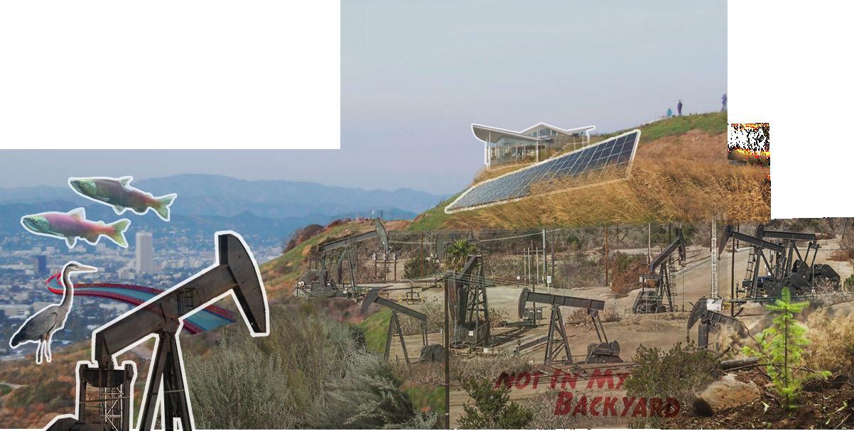
I’m reimagining Baldwin Hills to address the negative impacts of petroleum drilling on neighboring communities while creating innovative solutions for oil well land reclamation. Furthermore, I will develop a framework along Ballona Creek to reconnect fragmented communities and wildlife. This conglomerate of parks will stretch from Baldwin Hills to Marina del Rey and Venice Beach allowing visitors to experience a beautiful natural landscape that mitigates flood risk, filters stormwater, creates habitats, introduces native plant communities, and serves as a place of recreation. I will also pay homage to the rich African American history of the Baldwin Hills bringing it back to its previous zenith. It is my goal to tackle this challenge and help balance recreation, natural habitats, and urban facilities in a reimagined large-scale urban oasis.
Abstract
RESEARCH
FRAMEWORK
Project Description Goals & Objectives
Project Location
CONTEXT + SUPPORT
Planning Documents
Demographics Theories Precedent Studies Rationale
REFERENCES + RESOURCES
Annotated Bibliography
Professional Contacts
Project Timeline CONTACT Cover Letter Resume
contents
5 8-10 11 12-25 28-29 30-33 34-39 40-49 50-53 56-61 62 63 66 67
4

abstract
Phyto-Urbanism investigates the exploitive landscape of the Baldwin Hills oil field, in the heart of Los Angeles and the value of its wells after their finite lives. In tandem, the urban and environmental dissonance of the adjacent Ballona Creek creates an opportunity to explore a connection between both natural assets which in return will provide millions of people access to a large-scale urban sanctuary. Baldwin Hills will function as a collection of public parks and serve as the catalyst of community congregation and further park connectivity. The project vision aims to promote the ecological restoration of abandoned oil wells while providing a beautiful and multi-functional journey along the creek banks spanning from the coast to the Baldwin Hills. In continuation of Olmsted’s legacy, Phyto-Urbanism fosters a grand vision of a vast public green space in the densest landscapes of our planet.
5
Image credits: Al Seib / Los Angeles Times & Sammy Roth / Los Angeles Times
research framework
Project Description
Goals & Objectives
Project Location
The following chapter introduces the project and reflects the preliminary research that’s been conducted thus far. It will help clarify the main argument, narrative, and myriad of goals the project will address. This content remains the backbone of the design intent and highlights a tangible direction for further investigation. The project location and site images are displayed to emphasize areas of priority and to conjure new ideas that in combination, can create a richer more holistic project. The urgency to act now rather than later is a prevalent factor among the introductory component hoping to elucidate the importance of such research.
6
11
8-10
12-25
7
research framework
project description
project introduction project need design approach
PROJECT INTRODUCTION
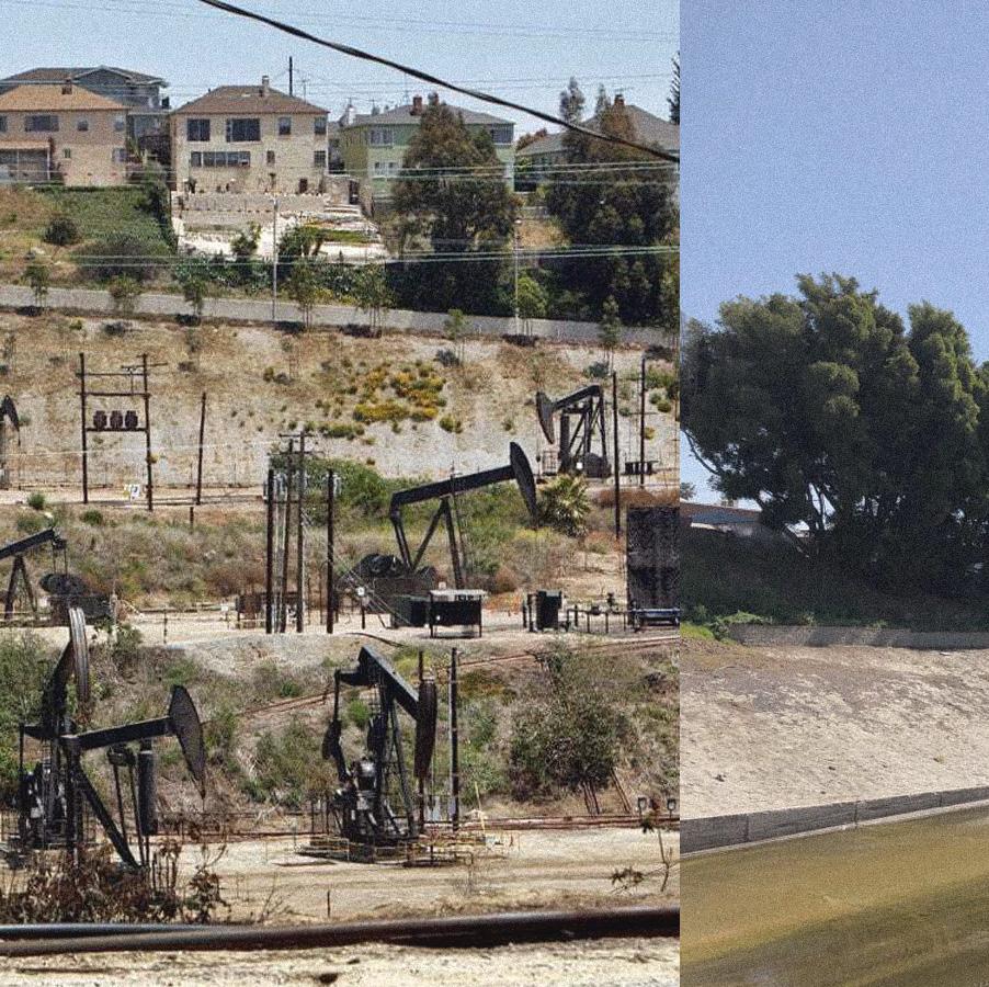
The Baldwin Hills remains the last undeveloped open space in one of the most densely population areas in Los Angeles. In 1924, oil and natural gas were discovered on the hills and have contributed to the local economy and fueled our extravagant lifestyle (also known as the Inglewood Oil Field). Simultaneously in 1935, the Army Corps of Engineers was tasked to alter the geometry of the adjacent Ballona Creek and convert its natural waterways into a controlled concrete channel. Both natural features were exploited and dominated for our benefit either for resource extraction or stormwater management. Although these industrial operations have provided many short-term benefits primarily through economic prosperity, the hindsight for
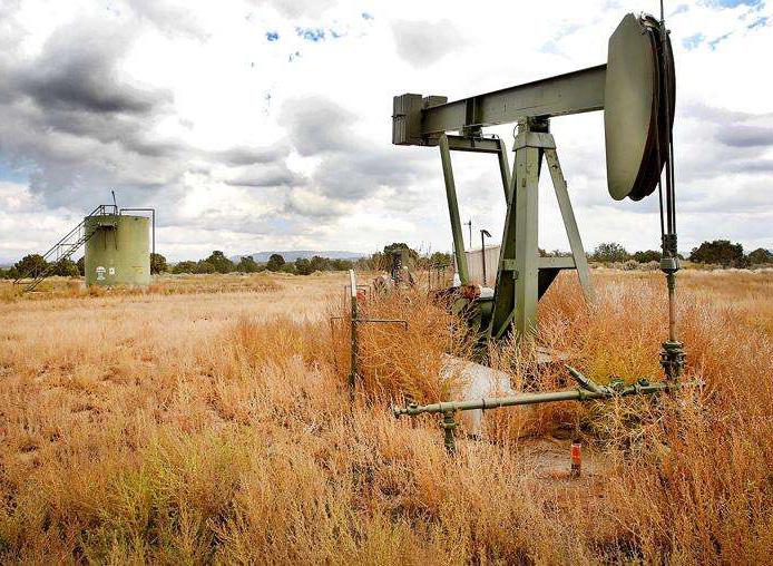
future consequences remains absent. Due to the finite supply of oil in the hills, the increasing risk of flooding, and the loss of cultural history, these once beautiful natural landscapes may become plagued by the current paradigm of urbanization. In the next few decades, the Baldwin Hills will become littered with abandoned oil wells, seeping toxic contaminants into the soils and waterways. Meanwhile, Ballona Creek is not equipped to withstand unprecedented storm events that may cost the city billions in infrastructure damages. In late 2023, an oil phaseout resolution was passed by the City and County of Los Angeles to ban a majority of the oil drilling on the Inglewood Oil Field due to the myriad of health impacts it has on local communities. Future development may face many challenges as the Baldwin Hills and Ballona Creek cover multiple jurisdictions all with polarizing incentives for future landscape use. Fortunately, there’s a large amount of public support that opposes oil drilling and hopes to transform the landscape into a public park. The importance of available green space in the matrix of urban systems is a valuable asset many local residents cherish.

8
Image
file abandoned oil well LA River cleanup Image credit: https://www.guidestar.org/profile/95-4171497
credit: Jerry McBride/Durango Herald
PROJECT NEED
The need for an innovative vision of the Baldwin Hills and Ballona Creek will help foster an eternal landscape that is active, environmentally considerate, and meets the complex needs of the surrounding community and wildlife. It will provide a sanctuary of escape for individuals suffering from urban fatigue and piece together the disconnected communities, places, and people of Los Angeles. Not only does wildlife struggle from their fragmented habitats, but Angelenos feel a disconnect from their communities due to the lack of access to parks and outdoor green space. The development of Baldwin Hills is inevitable, yet alternative landscape solutions can guide the preservation of its natural beauty and can create an oasis in the heart of Los Angeles.
The oil well blight of abandoned wells will drastically increase in the following decades thus addressing this issue now is paramount to successfully reclaim our burdened landscapes. Landscape architecture promotes sustainability, longevity, growth, and resilience and through strategic implementation of remediation efforts, future calamities can be avoided or mitigated. It’s a long and arduous process but design solutions must transpire sooner rather than later. Local communities have continuously fought against the oil drilling on the Inglewood Oil Fields as the health impacts have shown increased rates of asthma and cancer among individuals who live near drill sites. At the end of 2023, Culver City was successful in ending oil drilling and permanently capping its wells. This is a major step in environmental policy that may change the landscape function of these previous oil fields. North of Baldwin Hills, runs Ballona Creek which suffers from years of neglect and degradation. Its ability to serve the community
has slowly diminished and the waterways need an alternative renovation. Baldwin Hills can act as the catalyst of park connections and as the hub of retreat in Los Angeles while the corridor between the two natural features connects all the communities down to Venice Beach. As it provides connections between neighborhoods it will also equip the city with flood mitigation solutions.

Image credit: https://ogden_images.s3.amazonaws.com/www.sungazette. com/images/2021/09/27154558/28oilspillA.jpg
The LA River Master Plan (2022) has emphasized the importance of reconnecting the fragmented social, cultural, and ecological communities of Los Angeles. Ballona Creek, a smaller waterway and once a tributary of the main river can serve as a suitable area to implement these innovative resilience systems. At a smaller scale, there is increased flexibility and opportunity to apply design solutions and observe if the results are either sustainable or ephemeral. Transforming Ballona Creek can help inform the complex issues the region faces such as climate change, population growth, inequity, etc, and provide a valid framework that could be applied to the larger waterway.
9
oil spill
DESIGN APPROACH
The project hopes to preserve the large swath of underdeveloped land in Los Angeles, converting its littered landscape of oil wells into an attractive and environmentally focused place of congregation. The project will consist of multiple design phases: first it will address the issues of the oil field and its harmful industrial pollution, second it will focus on the connection between communities with attention on the corridor between the Baldwin Hills and Ballona Creek, and then it will develop a framework along Ballona Creek presenting alternative solutions for stormwater practices.
Instead of transforming the landscape into an unrecognizable place, the use of existing urban infrastructure can help allude to the evolution of the site and provide a unique approach to remediation efforts while considering existing conditions. Phytoremediation will play a vital role in environmental efforts helping clean pollutants and restore habitats of native flora and fauna. Additionally, the re-wilding of the Baldwin Hills and Ballona Creek can elicit the feelings of sublime for locals and tourists providing incentives to explore the new green corridors between communities. Through carefully selected programs the project can unify community needs and environmental restoration.
Recognizing the cultural history of the surrounding area will enrich the connections of ‘place’ to the community. The relics of the past can shape the program elements and features within the landscape potentially revealing unique narratives that allude to previous inhabitants. The African American influence in the Baldwin Hills area was at its peak after the Supreme Court struck down the enforcement of racially restrictive covenants in 1948. This enabled wealthy African
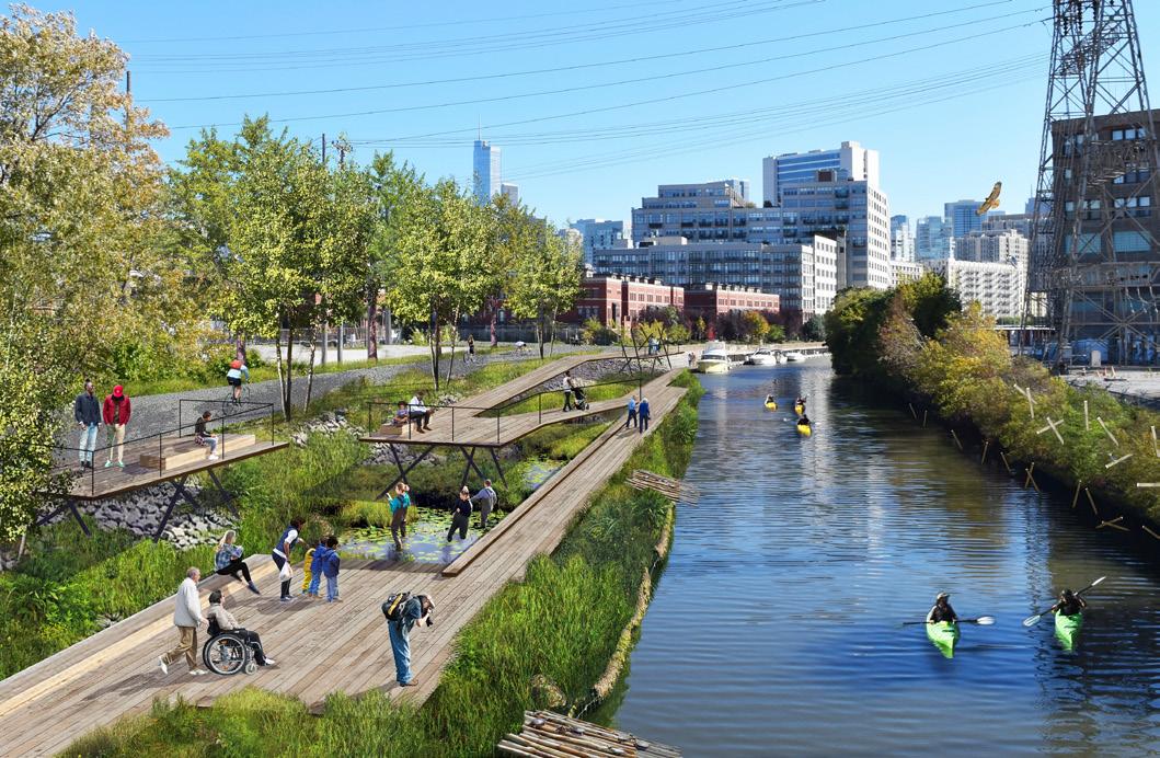
Chicago floating eco-park proposal
Image credit: https://som.medium.com/biomorphic-urbanism-a-guide-forsustainable-cities-4a1da72ad656 | © SOM
American families the opportunity to settle into the neighborhoods near the hills. Despite enduring two significant disasters: the 1963 Baldwin Hills dam collapse and the 1985 Baldwin Hills fire in combination with years of racial prejudice, their influence has prevailed and the community is historically known as “the hub of black upper-andmiddle class life in Los Angeles”. To help maintain the Baldwin Hill communities that are associated with African Americans and their historic legacy, a thoughtful balance between developing new amenities while accommodating accessible opportunities for current inhabitants can reduce the departure of African American families.
Three fundamental concepts play a critical role in the performance of the project. The sagacious future vision of the Baldwin Hills will incorporate the reclamation of the oil field, the revitalization of Ballona Creek with a connection between both natural features, and the recognition of African American history. These three concepts will become interwoven into a holistic program that expresses the most vital facets: environmental health and human health.
10
goals & objectives
REMEDIATE OIL WELL BLIGHT POLLUTION OF ACTIVE AND ABANDONED WELLS
• develop an effective phytoremediation plant palette to clean soil contaminants
• permanently plug abandoned oil wells and transform land for multi-functional use
• cultivate biological soil crust to help filter contaminants and provide healthy soil
1
CONNECT THE NORTHERN SIDE OF BALDWIN HILLS WITH BALLONA CREEK
• provide an accessible green corridor through Jefferson Blvd
• create notable entry points into Ballona Creek possible with a pedestrian bridge
• use wayfinding and signage to garner foot traffic into both natural features
PROVIDE A PLACE OF RECREATION AND RETREAT FOR LOCALS AND TOURISTS
• implement meandering trails for different modes of transportation
• utilize viewshed of the city through observation decks and lookouts
• create unique areas through topography change, water, and vegetation
2
PAY HOMAGE TO THE RICH AFRICAN AMERICAN HISTORY OF BALDWIN HILLS
• recognize the culture influence of African American through program elements
• reduce gentrification through open green space preservation
• provide amenities that the communities directly needs and wants
3
REDUCE FLOOD RISK AND IMPROVE RESILIENCE OF BALLONA CREEK
• naturalize the riverbed through removing concrete and replacing it with vegetation
• identify areas to expand stormwater collection and water filtration
• alter geometry of Ballona Creek through lowering channels, raising levees, etc
PROVIDE A SAFE CONNECTION FROM BALLONA CREEK TO VENICE BEACH
• redesign the existing bike trail along Ballona Creek for an improved experience
• activate unused spaces along the riverbed for safety and security
• create a more inviting landscape through enticing programs elements and forms
4 5 6
11
project location
site location
site plan
site images
LOS ANGELES, CA
As one of the largest and most populated cities in the world, Los Angeles is an excellent candidate for a large-scale urban park. Almost all of the city has been developed, however one last large swath of land has yet to fall victim to urbanization. This is due to the continuous oil drilling on the Inglewood Oil Field since the 1920s and the complex conglomerate of land ownership and polarizing opinions. Located near the coast and in one of the densest areas in LA, the imminent landscape littered with abandoned oil wells can transform into Griffith Park’s new cousin providing millions of individuals access to a public green space for recreation, relaxation, and stunning views of the city.
ADJACENT CITIES/COMMUNITIES
• Culver City
• Ladera Heights
• View Park-Windsor Hills
• Crenshaw
• Baldwin Hills
• Del Rey
• Marina Del Rey


12
BALDWIN HILLS
View Park Windsor Hills Baldwin Hills
Ladera Heights
Culver City
Santa Monica
Downtown
Los Angeles
Image credits: Google Earth
REGIONAL SCALE
The site is surrounded by four cities/communities that include a high percentage of African American residents. This demographic has faced decades of adversity and systemic racism. The project can further support and connect these communities.
Los Angeles

SITE LOCATION
The focus area on the Baldwin Hills will encompass all the oil wells and industrial equipment, the main arterial dissecting the landscape, the small reservoir on the east, and the north connection to Ballona Creek. The edge conditions of the Baldwin Hills are dominated by established parks such as the Kenneth Hahn Hummingbird Garden, soccer fields, disc golf course, recreation area, Culver City Park, and the Baldwin Hills Scenic Overlook. These will serve as the initial catalyst to park connection and park expansion.
Culver City Baldwin Hills View Park Windsor Hills Ladera Heights Inglewood Santa Monica Marina Del Rey 13
Image credits: Snazzy Maps
existing city maps
watershed communities
creek bikeway park access
LOS ANGELES
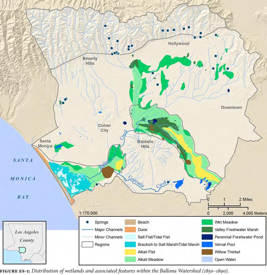
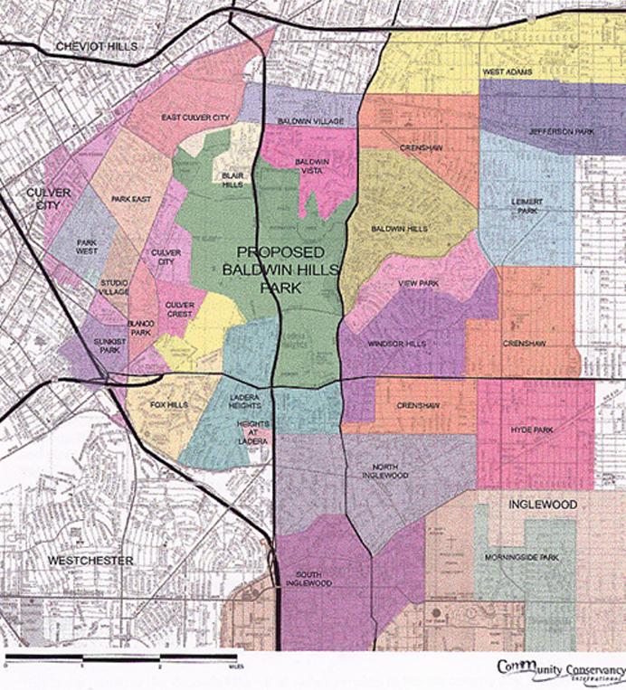
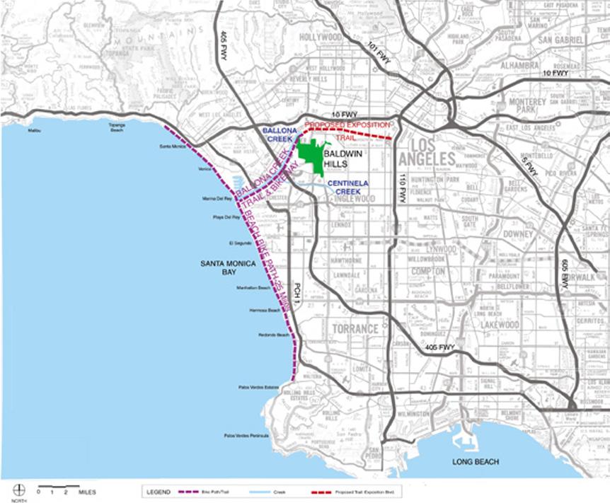
Analyzing the Ballona Creek watershed can provide valuable information on the hydrology of the site and the features associated with its tributaries. As a high point within the watershed, Baldwin Hills drains into Ballona Creek which spans all the way west to Santa Monica Bay. Flood risk reduction and water filtration practices can be further explored for implementation on the site. The site is recognized as an unincorporated area. The nearest adjacent city is Culver City followed by multiple communities that surround the site. These include Blair Hills, Baldwin Vista, Baldwin Hills, View Park, Windsor Hills, and Ladera Heights. The park spaces per capita and bikeway connectivity,provide insight into the level of needs of the surrounding communities. They indicate that there is a major disconnect from north to south and that the Baldwin Hills could serve as a network between these communities.
site location
14
Distribution of wetlands and associated features. Image credit: Historical Ecology of the Southern California

15

Runoff watersheds for Los Angeles Image credit: https://www.pbssocal.org/shows/earth-focus/what-is-a-watershed-anyway
16
Neighborhoods of the Baldwin Hills Image credit: Baldwin Hills Park Master Plan
17
18
Ballona Creek trail & bikeway connection
Image credit: Baldwin Hills Park Master Plan

19
Map of park space* per capita by city and community Image credit: Parks and Public Health in Los Angeles County A Cities and Communities Report
existing site maps
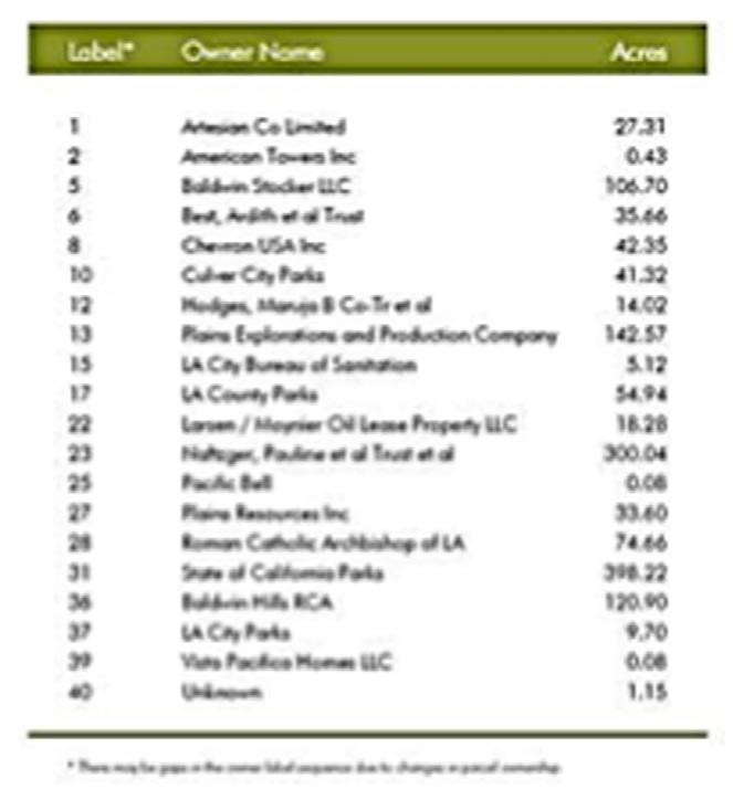
oil wells area/land ownership
The Baldwin Hills presents an arduous challenge as it harbors a sprawling industrial site with numerous oil wells, pipelines, and infrastructure scattered around the landscape. It’s also located in a landscape with complex jurisdictions, environmental hazards, and steep topography. The site has been attempted by multiple designers, yet it seems there remains a bulwark along the way. New innovative solutions through careful examination of site maps and data can elicit a divergent perspective on how to approach the Baldwin Hills. Once all the necessary information is collected, we can begin understanding how to enhance the sense of place of the landscape through a unique lens centered around oil field reclamation, creek revitalization, and cultural recognition.

20
BALDWIN HILLS & BALLONA CREEK
Baldwin Hills area ownership Image credit: Baldwin Hills Conservancy Strategic Plan Update (2020)


Active oil wells & active water flood/injection wells Image credit: https://cleanbreak.info/la-county-drilling-baldwin-hills-inglewood-oil-field/

21

22 site plan

ballona creek
main streets
existing schools
existing parks
not to scale
23
site images
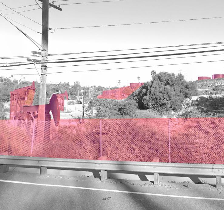
This photo is taken north of Stocker Street. It shows a landscape littered with oil wells, silos, and other industrial equipment.
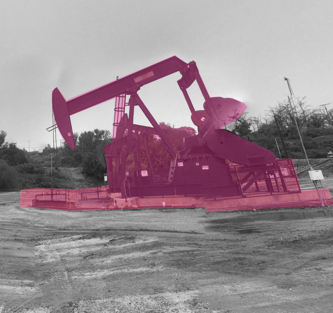
Oil wells are large in scale and pose a difficult challenge when abandoned. Most of the area around the wells are barren and flat.

The site encompasses a large portion of the Baldwin Hills and includes the majority of oil wells on the Inglewood Oil Fields, the northern connection to Baldwin Creek, and the main thorough-way, La Cienega Blvd, to address the main goals.
24
THE SITE

On the northern part of the site, is a pitiful crosswalk connecting the Baldwin Hills to Ballona Creek. It’s heavily trafficked and may be a risk to pedestrians.

At the end of Duquesne Avenue, there is a gate that prohibits public access. It’s one of the many entrances into the Inglewood Oil Field.

East of La Cienega Blvd, is where a small reservoir, Gwen Moore Lake remains. It’s a spectacle to the public and a wildlife sanctuary. Access to the lake is limited and further improvements could bring a sense of place to the area.
25
Image credits: Google Maps
context + support
50-53
The following chapter utilizes a collection of core material research as reference for further exploration. Existing master plans of the site were reviewed to understand current problems and alternative solutions. Demographics of the surrounding communities are presented through infographics to support the impact and performance of design solutions, helping distinguish the populations that will be most affected.
Three theoretical reviews and five case studies were carefully examined for potential application. These include scientific studies on plant phytoextraction effectiveness, blending urban and natural systems, and utilized BSC in damaged landscapes. Additionally, recognizing successful precedents will contribute to the growth of knowledge in the field. This is through the the testing of viable solutions and layering new information. The rationale provides the motivation and reason why pursuing this project is imperative.
26
Planning Documents
28-29 30-33 34-39 40-49
Demographics Theories Precedent Studies Rationale
27
context + support planning documents
Baldwin Hills CSD (2008 - present)
Baldwin Hills Park Master Plan (2002)
LA River Master Plan (2022)
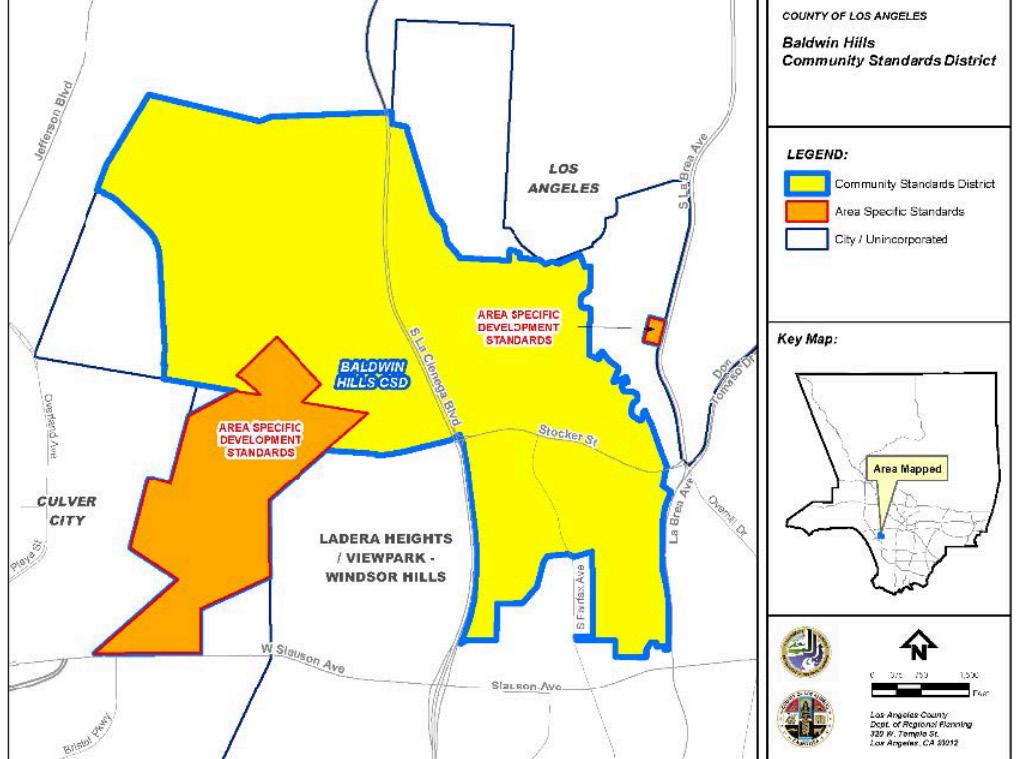
The Baldwin Hills CSD was developed to provide measures for implementing regulation, safeguards, and control for activities related to oil drilling and production within the Baldwin Hills area. The document seeks to reduce the impacts of operations and to regulate operations so they are compatible with adjacent land uses and enhance the appearance of the site. For oil field cleanup and maintenance, the operator should remove any equipment that has reached the end of their “useful economic life” and is prompted to be removed from the oil field within one year. Once equipment is removed from the area, the land will be restored and revegetated within 90 days of termination. Abandoned well testing is also conducted to obtain annual hydrocarbon leakage to determine removal.
LA RIVER MASTER PLAN

The LA River Master Plan’s research is based on watershed analysis and community engagement, therefore it provides a unique guide to develop tangible design solutions for the 51-mile river that spans and impacts millions of LA residents. The plan is organized into four sections: first, it introduces their vision, then it provides the context of the LA River, it describes the goals, actions, and methods of planning, and finally forges a way forward for successful implementation. The master plan addresses multiple issues associated with the river’s current characteristics in response to increased urbanism and climate change. Flood risk reduction remains an urgent issue within the city and the document can guide and prepare the river for extreme storms by maintaining existing flood conveyance capacity, increasing capacity in deviant reaches, and advancing community resilience in a storm’s aftermath. There are significant cost considerations for flood risk mitigation including modifying the river’s geometry, bridges, bypass tunnels, etc. Emergency strategies can provide measures for future storm events.
28
BALDWIN HILLS CSD
Image credit: Baldwin Hills Community Standards District
Image credit: LA River Master Plan
BALDWIN HILLS PARK MASTER PLAN
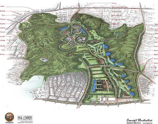
The Baldwin Hills Park Master Plan proposed in May 2002, serves as a guide for future development of a natural open space and park which includes improvements, facility development, and habitat restoration. The plan reflects stewardship for the Baldwin Hills biological resources and listens to community needs. The Baldwin Hills is the last undeveloped swath of open space in the densest part of LA. It sits in a portion of the 127 square mile Ballona Creek Watershed which flows through the Ballona Wetland and towards Santa Monica Bay. The hills drain into Ballona Creek and are susceptible to erosion and catastrophic mudslides. Retaining the site’s natural characteristics can aid in long-term water quality. There are hundreds of abandoned wells in the Baldwin Hills area that are at risk of hydrocarbon leaks if regulated improperly. The plan hints at the adjacency of Ballona Creek and how it can connect and provide unique recreation for millions of residents in urban LA.

CONNECTION
My vision for Baldwin Hills has three primary goals: i). oil well reclamation efforts through nature-based solutions, ii.) cohesion and connectivity to Ballona Creek, iii.) maintain and celebrate the rich African American history within the area. The other layers such as soil & water quality, flooding, habitats, recreation, physical & mental health, NIMBY, etc will be addressed through these main goals.
The three master plans I focused on provide an understanding of a niche agenda for the site and its issues. When combined, they provide a holistic approach to design solutions and thinking. Oil production on the hills remains a considerable threat to the neighboring communities, therefore the Baldwin Hills CSD provides tangible efforts to help mitigate the risks while also advocating for new city ordinances. The new LA River Master Plan highlights strategies to enhance the LA River’s network and promotes a multifunctional place that improves the lives of millions of LA residents. The most valuable information to use for Ballona Creek is flood risk reduction, water quality, and connectivity. The Baldwin Hills Master Plan is an ambitious proposal for a grandiose park to help preserve the last open space resource in the area. It would be the largest-scale park ever created in the US in such a densely populated urban setting.
29
Image credit: Baldwin Hills Park Master Plan
Image credit: Baldwin Hills Park Master Plan
demographics
ethnicity
median age
median income by household
CULVER CITY, LADERA HEIGHTS, VIEW PARK-WINDSOR HILLS, BALDWIN HILLS
Baldwin Hills/Inglewood Oil Field sits in an unincorporated zone within the heart of LA. It’s surrounded by one city (Culver City) and three notable communities (Ladera Heights, View Park-Windsor Hills, and Baldwin Hills). The ethnicity, median age, and median income are graphically shown for each community. The smaller communities share similar data, however since Culver City encompasses a large portion of west LA, its data represents a disparate demographic. All the initial data obtained will help inform planning efforts and zoning. Additional demographic research will determine subgroups of income, education, health, economy, and transportation. This will ensure a holistic approach to inform who we are impacting through our design efforts.
culver city population: 39,515 (2022)
ladera heights population: 6,814 (2024)
view-park windsor hills population: 12,377 (2024)
baldwin hills/crenshaw population: 32,492 (2022)
ethnicity
other race other race other race two or more black asian asian asian two or more two or more two or more white asian white white hispanic white black black black 55.77% 64.23% 73.72% 53% 17.6% 17% 11.92% 31% 14.73% 12.15% 8% 8% 3.55% 5.86% 5% 3.9% 3.07% 3.67% 4.83% 3% 30
baldwin hills data n/a

culver city
32,572 adults, (6,987 of whom are seniors)

ladera heights
5,520 adults, (1,476 of whom are seniors)

view-park windsor hills
10,089 adults, (2,855 of whom are seniors)
median
median age
income by household type
41.5 total 42.9 total 47.9 total 42 total 43.5 female <10K <10K <10K 0 0 0 10 20 30 40 10 10 20 20 30 30 40 40 50 50 10K-15K 10K-15K 10K-15K 15K-25K 15K-25K 15K-25K 25K-35K 25K-35K 25K-35K 35K-50K 35K-50K 35K-50K 50K-75K 50K-75K 50K-75K 75K-100K 75K-100K 75K-100K 100K-150K 100K-150K 100K-150K 150K-200K 150K-200K 150K-200K >200K >200K >200K 47.9 female 52.2 female 45.8 female mean household income of all communities $136,762 39.3 male 41 male 44.3 male 41.6 male
$ households households households families families families married families married families married families non-families non-families non-families 31
baldwin hills/crenshaw
user profiles
speculative potential occupants unique characteristics
CULVER CITY, LADERA HEIGHTS, VIEW PARK-WINDSOR HILLS, BALDWIN HILLS
Based on speculation, these are the general user profiles that interact with or are affected by the site. Their voices will be recognized throughout each design phase, hoping to provide insight into design decisions. The site will attempt to fulfill the needs of the community while also meeting the three primary goals previously stated: i). oil well reclamation efforts through nature-based solutions, ii.) cohesion and connectivity to Ballona Creek, iii.) maintain and celebrate the rich African American history within the area. Ultimately, the new landscape will serve the entire community of Los Angeles providing a natural open green space to escape the exhaustion of living in a dense urban city. The site hopes to conjure a sense of biophilia and relaxation for individuals.


32
middle-aged african americans
married families
industrial workers
fitness enthusiasts
The majority of individuals living in the surrounding communities are African American and in their early 40s. This demographic is prominent within three of the adjacent communities and alludes to the area’s cultural history. The Baldwin Hills were once known as the “Black Beverly Hills” with hundreds of African American homeowners. This population has endured decades of adversity with little to no representation, and combined with the threat of gentrification, African Americans face yet another challenge in their communities.
The most prominent users in the area are families with high-income status. This population is directly impacted by the oil drilling on Baldwin Hills and are the advocates for environmental community standards. As they raise their children in the vicinity, they expect a safe and sustainable landscape that will cater to the next generation. Their voices will be the most dominant during design phases and will influence critical decisions.
As oil drilling phases out in the next few decades, industrial workers will play a crucial role in disassembling oil wells and other industrial equipment. They are currently the most active users in the Baldwin Hills as oil drilling continues to occur. The design efforts plan on transforming the landscape function of the oil field into a public open space thus negotiation and planning must consider the job security and opinions of these workers.
The Baldwin Hills currently attracts a slew of hikers, joggers, and walkers to its meandering trails. This population has interacted with the site more than anyone else and understands the sense of place within certain areas. Their opinions will influence design decisions and provide insight into current strengths and weaknesses. Recreation, connectivity, and access plays a vital role in attracting more enthusiasts to the site.
33
theory #1
phytoextraction
Enhanced Accumulation of Copper and Lead in Amaranth ( Amaranthus paniculatus ), Indian Mustard ( Brassica juncea ) and Sunflower ( Helianthus annuus )
Motior M. Rahman, Sofian M. Azirun, & Amru N. Boyce May 8, 2013
PLOS ONE
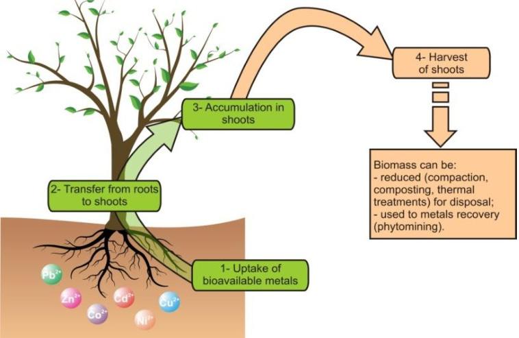
The process of phyto-extracation. Image credit: Favas et. al, 2014.
SUMMARY
Soil contamination from industrial sites has become a widespread environmental problem. Heavy metals including copper (Cu) and lead (Pb) remain a threat to local communities and wildlife, thus phytoextraction was tested to determine the viability of environmental remediation strategies. The study investigates the use of nitrogen (N) fertilizer as an efficient way to enhance the accumulation of Cu and Pb from contaminated industrial soils. Three plants were tested including Amaranth, Indian Mustard, and Sunflower. High levels of metals in soil can result in the degradation of soil fertility and poor quality of agricultural products and pose significant threats to an ecosystem’s well-being with risks of underground
and surface water contamination. Phytoextraction was developed as a costefficient and less hazardous alternative to remediate contaminated soils. It consists of using plant materials in the removal of metals through uptake and accumulation into biomass. The uptake of toxic metals is influenced by the plant species, the growth stage, soil type, the type of metals, and environmental factors. Metal concentration also plays a vital role in controlling metal availability in plants. The performance benefits of this practice result in an aesthetically pleasing landscape, healthy soil microorganisms, and enhanced biodiversity. Plant considerations include faster and more effective biomass-producing plants that can tolerate and accumulate heavy metals.
The greenhouse experiments conducted at the University of Malaya, Kuala Lumpur, Malaysia investigated the effect of (N) on the growth of Amarath, Indian Mustard, and Sunflower plants in soils contaminated with heavy metals. Soil samples were collected from a depth of 0-30 cm and characterized as sandy loam. The plants were grown in polyethylene pots filled with contaminated soil, with varying levels of N fertilizer added. The experiment used a randomized design with six replications for each treatment. After 56 days of growth, the plant’s biomass and metal accumulation were assessed. Statistical analysis, including one-way ANOVA and t-test, was performed to assess significant differences in plant biomass and metal concentrations among treatments. The study revealed that Sunflowers exhibit a significantly higher capacity for copper (Cu) and lead (Pb) accumulation
34

Nitrogen, lead and copper concentration in plant tissues. Image credit: https://doi.org/10.1371/journal.pone.0062941.t003
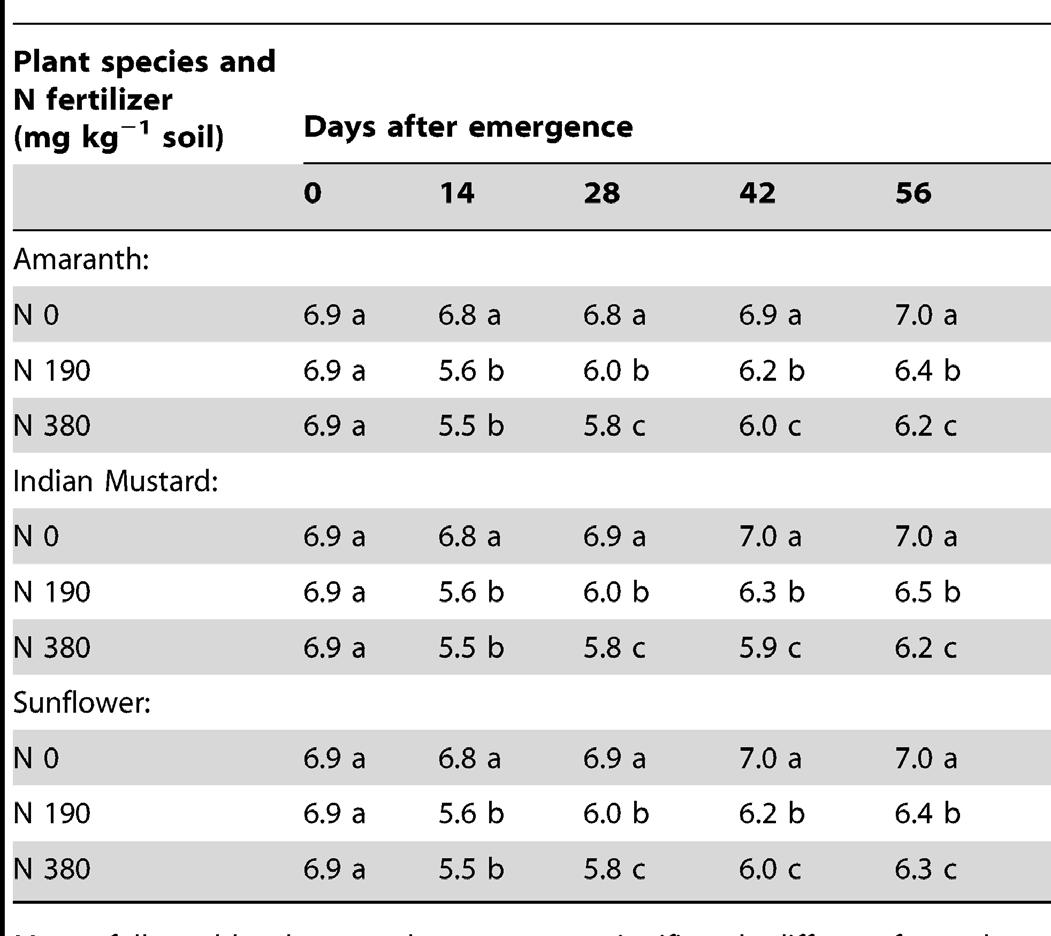
compared to Amarath and Indian Mustard. Furthermore, it displayed a positive correlation between the application of nitrogen (N) fertilizer and plant growth, leading to an increased uptake of the metals. However, excessive nitrogen (N) fertilizer application could promote rapid aboveground growth at the expense of plant strength. Applying phosphorus is recommended to promote root growth and balance shoot development. Sunflower was the most effective plant species for phytoextraction due to its hyperaccumulator characteristic. This study underscores the need for a balanced approach to soil remediation.
CONNECTION
The process of phytoextraction and the results of the study present applicable design solutions for oil field soil remediation and water pollution. Through utilizing plant materials and their unique biotic processes, the contaminated areas along Baldwin Hills and Ballona Creek can be a haven for vegetation and restored plant communities. Plants have various environmental benefits within urban settings including our innate relationship with nature. Not only will vegetation promote and foster a healthier landscape it can also boost mental fatigue and stress among Los Angeles residents. Plant selection will remain paramount during further investigation into the site.
The study confirms that Sunflower is an effective hyperaccumulator of heavy metals and suggests this species could be planted in the most contaminated areas on the site. Urban runoff pollution and oil contamination pose a risk to the adjacent communities and Ballona Creek.
Integrating nature-based solutions through phytoextraction/remediation can result in a cleaner and more naturalized area. It can address contamination issues and improve water quality. Native plant species with hyperaccumulating characteristics such as grasses, reeds, and trees can be strategically planted along the riverbank to absorb pollutants such as toxic metals, hydrocarbons, and other contaminants. They act as a natural filter, trapping larger pollutants and enhancing water flow to the ocean.
Phytoextraction/remediation offers a sustainable and cost-effective approach to reclaiming oil fields in LA. Various plant species including Sunflowers can accumulate pollutants present in the soil and groundwater. This process will slowly regenerate the oil-well-littered landscape for alternate and positive uses including public parks, food production, natural habitats, and green corridors.
35
Soil pH influenced by N fertilizer with Amaranth, Indian Mustard and Sunflower grown in industrial soils over time.
theory #2
flood control freakology
Alternative theory examining the Los Angeles River Watershed
David Fletcher
2008 ACADEMIA
SUMMARY
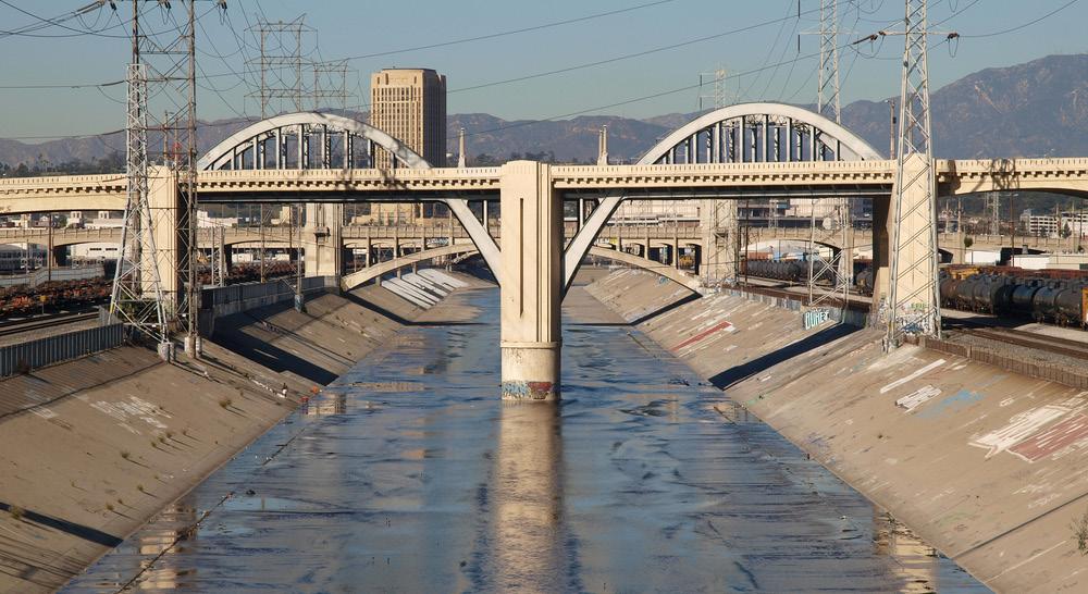
The LA River traverses one of the most complex urban watersheds spanning 51 miles from its headwaters in the San Gabriel Mountain to the Pacific Ocean. The river, once characterized by its natural meandering state, has gone through extensive engineering to become a floodcontrol system, reshaped by a matrix of concrete channels and storm drain infrastructure. This transformation had a significant impact on its physical appearance and negatively shifted public perception. Fletcher highlights a counter-narrative arguing that embracing the current engineered and ecologically diverse state is essential for understanding its contemporary significance. Amidst the decadent concrete form,
The LA River boasts a diverse array of vegetation, wildlife, and habitats.
Within the river’s altered landscape are layers of political, social, and environmental complexities that shape governance and management. The theory highlights the fragmented governance structure, spanning the federal, state, local agencies, and private landowners creating various challenges in coordinating management and design solutions for a new innovative river. Furthermore, the river serves as a focal point for various social dynamics, with homeless encampments, transience individuals, and illicit activities, revealing the intersection of urbanization, poverty, and environmental justice issues along the riverbank.
Despite its engineered appearance, the LA River ecosystems foster an exceptional natural hub, hosting various native species that have adapted to the altered conditions. Fletcher explains the importance of recognizing the river’s “freakologies” that have emerged in response to dense urbanization and human intervention. Rather than viewing these ecosystems through a lens of loss and restoration, the theory advocates to embrace the river’s plurality and acknowledge the vital roles it plays in supporting urban biodiversity and ecological function. However, the LA River faces many pressing issues including flooding, water scarcity, pollution, habitat loss, and contamination. The urgent need for holistic planning that integrates ecological restoration and BMP while also considering social and economic dynamics ensures an equitable feature for the community.
36
Photo of the existing condition of the Los Angeles River. Image credit: trekandshoot/shutterstock
According to Fletcher, reimagining the future of the LA River must be through the development of new narratives and strategies that capture its multifaceted characteristics. Rather than prioritizing the process of completely naturalizing the river, efforts should focus on understanding and appreciating its current condition as an urban artifact. This requires a shift in perspective, embracing the river’s inherent value of its diverse ecosystems. By integrating this narrative into planning and design, holistic solutions can ensure the long-term health and vitality of the LA River while also mitigating various environmental issues.
CONNECTION
The Flood Control Freakology theory presents an alternative narrative to how we perceive the LA River and Ballona Creek. Instead of a siloed agenda of reverting the riverways into a naturalized environment, the design could mix urban infrastructure with natural elements to enhance the current ecosystems in the river. Urbanization creates unique ecosystems; some have negative traits and consequences while others can foster various types of native species. Recognition illicits a holistic approach where both nature and urbanism coexist harmoniously. It’s a fantasy to fully revert to a naturalized river, we must integrate components of urbanism while addressing environmental issues.
Much like the LA River, Ballona Creek faces the same challenges related to urbanization, development, and ecological degradation. Insights into LA River’s transformation from a natural waterway to an engineered flood control system can inform decisionmaking and reveal similarities between the two.
Further research into Ballona Creek’s ecology can allude to the concept of ecological succession, the changes due to the disturbance of animal and plant communities over time. There has been an increased emphasis on natural disturbances such as fire, flood, tornado, and earthquake as integral ecological processes. Thus, stability in nature is an illusion. However, with increased issues due to climate change, the frequency of these natural disturbances has multiplied causing mass calamity within our populated areas.
The term “revitalization” is commonly referred as the recuperative agent for societal wrongdoings. This narrative implies that radical change in our dogmatic practices of land use is the only solution. Rather, we reevaluate the vocabulary behind what we define as “river” and “nature” to integrate our urban freakologies into future landscapes that will ensure realistic outcomes.

37
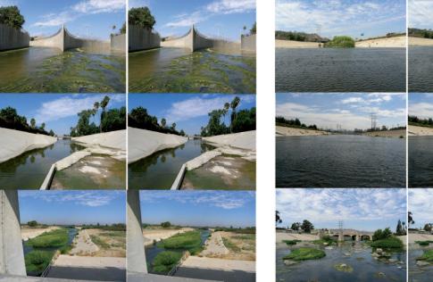
Collection of photos showing the conditions of the LA River.
Image credit: David Fletcher
Political jurisdictions of the Los Angeles River Watershed. Image credit: David Fletcher
theory #3
BSC rehabilitation
Biological Soil Crust Rehabilitation in Theory and Practice: An Underexploited Opportunity
Matthew A. Bowker
February 16, 2007
WILEY Online Library

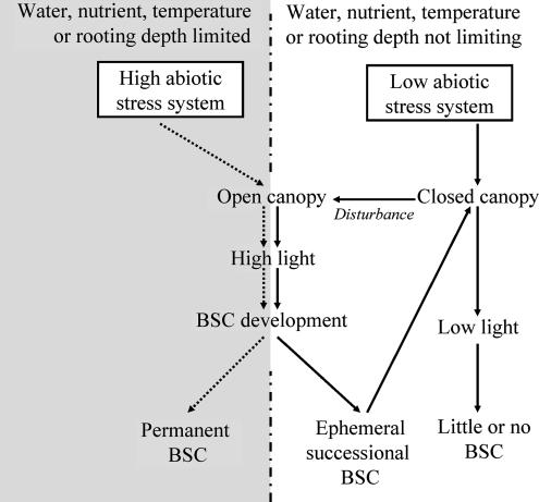
BSCs as the key components of high abiotis stress ecosystem.
Image credit: Brotherson & Rushforth 1983, et al
SUMMARY
The study explores the pivotal role of Biological Soil Crusts (BSCs) in our ecosystems, particularly in drylands due to their soil quality, ecosystem functions, and restorative ecology. BSCs are intricate communities of organism including lichens, mosses, and cyanobacteria that form cohesive thin horizontal layers on soil surfaces. They are common in communities with high light input (approximately 40% of terrestrial ecosystems) There is a significant gap in literature research that addresses their role in rehabilitation. Bowker implores that recognizing and integrating BSCs into restoration efforts can aid in soil stability, water retention, nutrient cycling, contaminant accumulation, and facilitate ecological succession.
The key findings highlight the limited attention given to BSC despite their success in restoration ecology. Bowkey presents empirical evidence demonstrating the positive impacts of BSCs on soil quality and ecosystem health, through numerous experiments testing their effectiveness in soil aggregation, temperature regulation, water infiltration, and nitrogen fixation. They also reduce the lengthy time frames associated with landscape succession and restoration. Bowkey also highlights the relationships and interactions between BSCs and vascular plants, stating that BSCs are typically the instigators of plant colonization and succession and help develop a healthy plant community. This further emphasizes the need to understand the nuanced interactions to inform successful strategies
BSCs are an integral part of undisturbed ecosystems and their removal can trigger profound transitions leading to desertification and loss of ecosystem services. The study discovers new data indicating the vulnerability of BSCs in high abiotic stress ecosystems and the consequences of their loss for ecosystem states and functions. Through the lens of state-and-transition models, the study proposes a conceptual framework for BSC rehabilitation, which encompasses creative guidelines to monitor BSC communities and their response to disturbance. Rehabilitation efforts are practiced under the SER approach, strict-sense ecological restoration which is the assisted recovery of damaged ecosystems and attempts to return them to their historic trajectory.
38
Bowker suggests that a large number of studies prove that BSCs provide an important ecosystem function, and their reestablishment is a necessary component of the restoration of multiple global ecosystems. In the low abiotic stress sites, assisted recovery of ephemeral BSCs may facilitate the establishment of later successional species. In arid and high abiotic stress systems, loss or addition of BSCs may induce a transition from one landscape state to another. BSCs’ pervasive influence over landscape function should be viewed as an opportunity to advance the trajectory of whole systems in the effort of ecological restoration.
CONNECTION
The data from the BSCs research highlights critical patterns in ecosystem stability and functionality in the Baldwin Hills. Prioritizing the protection and implementation of BSCs into the landscape can enhance the resilience of the design and mitigate the effects of oil drilling. Since BSCs have an impact on ecosystem state transitions, a proactive approach can help prevent desertification and maintain ecosystem stability. Oil well reclamation will become a common landscape practice within the next few decades, thus understanding the microorganisms and their processes within the land will aid in the development of innovative design solutions to bolster longevity and growth.
Applying state-and-transition models to understand the dynamics of ecosystem recovery will guide phases of restoration. The Inglewood Oil Field has a vast network of meandering hills and paths thus, this method can help optimize the effectiveness and cost-efficiency of reclamation by focusing on areas that are under the most threat. Even after implementation, monitoring BSC communities can help clarify if further action is needed. Developing monitoring protocols in the design while also following adaptive approaches can measure the effectiveness of BSC restoration over time. This will aid in adept future visualization decisions and create sustainable landscape performances.

39
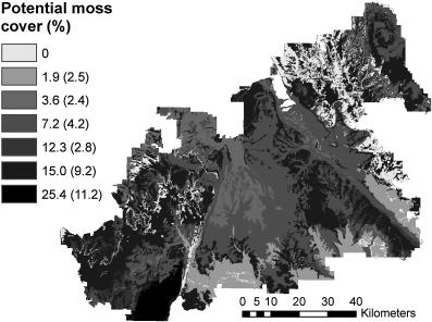
Spatial model depicting potential cover of one BSC.
Image credit: Bowker et al, 2006
High abiotic stress systems vs. low abiotic stress systems. Image credit: Grime, 1979
precedent study #1
balboa
park
location: San Diego, CA
designer: Bertram G. Goodhue
year: 1915
The City of San Diego: Parks & Recreation
OVERVIEW & APPLICATION
Balboa Park, located in San Diego is a 1,000acre site made up of a collection of museums, various gardens, art and international culture associations, and the San Diego Zoo. The fusion of public amenities offers the city a place of urban refuge as it remains the hub of historic education and recreation. It’s characterized as a largescale urban park just a few minutes away from downtown San Diego and attracts visitors through its brilliant display of seasonal flowers, shady groves of trees, and meandering paths cutting


through the large lawns. This precedent presents a successful approach to urban park design and the potential to connect the existing park around the Baldwin Hills through an immersive landscape. The recognition of the rich ethnic diversity of San Diego is reflected through the park’s institutions. It offers residents of San Diego many opportunities for picnicking, hiking, family play, and dog walking.

40
Photo of topiary garden at Balboa Park. (Charles A. Birnbaum, 2011)
Balboa Park facilities map.
Magnificent historic museum housing relics of the past.
Environmental benefits for consideration:
• earned LEED certification in 2021
• 100 water retrofit and energy efficient projects have been completed
• reduces 5,139 metric tons of carbon dioxide equal to 1,091 vehicles per year
Social benefits for consideration:
• the park is rich in educational programming for children and teens
• museum help celebrate the unique cultures of the past
• connects the San Diego community
Economic benefits for consideration:
• one of the major economic generators
• it draws in 14 million visitors each year
• has a $356 million economic impact
• saves many residents millions in recreational expenses
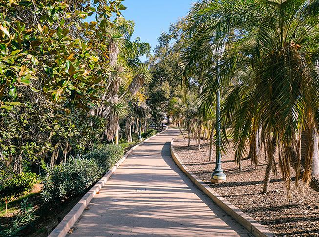


The Botanical Building surrounded by a reflection pool and lush vegetation. Image credit: https://assets.milestoneinternet.com/sunland-rv-resorts/siteimages/blog/san-diego-balboa-park-feat.jpg
41
Brilliant display of flowers providing floral interest.
The meandering paths of Balboa Park.
precedent study #2
vista
hermosa
location: Los Angeles, CA
designer: Studio-MLA
year: 2008
Landscape Performance Series Case Study Briefs
OVERVIEW & APPLICATION
Vista Hermosa is the first public park built in downtown Los Angeles in over 100 years. As a former oil field, it provides residents in working-class neighborhoods many opportunities for active and passive recreation and access to the restorative qualities of nature. The design transformed once a dangerous and contaminated vacant lot into a park that supports science education and promotes the growth of native flora. Much of the site was polluted with hydrogen sulfide and methane gas thus the design team removed the top 36” of topsoil,
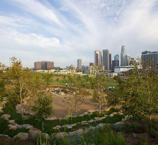
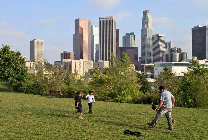
added 18” of sand, and then placed 18” of new topsoil on top. This approach forced the harmful gases to move slower and horizontally beneath the surface reducing the risk of exposure. Synthetic membranes and vertical risers were also used to prevent the accumulation of toxic gases from escaping under the impermeable slabs beneath park buildings, cisterns, and adjacent buildings.

42
Large boulder amphitheater with waterfall feature.
Vista Hermosa site plan.
stunning views for residents and families as they play in the park.
Environmental benefits for consideration:
• sequesters roughly 22 tons of atmospheric carbon annually
• home to over 800 trees
• provices critical habitats for the Pacific Flyway corridor for 60 bird species
Social benefits for consideration:
• increased the average park acreage per 1,000 residents by 13% in Westlake
• supports 4 additional recreational and social activies
• educates 1,485 visitors per year
Economic benefits for consideration:
• saves roughly $70,000 in irrigation and maintenance costs annually
• creates 2.5 full time equivalent jobs
• generates a projects $87,000 in annual revenue from park operations
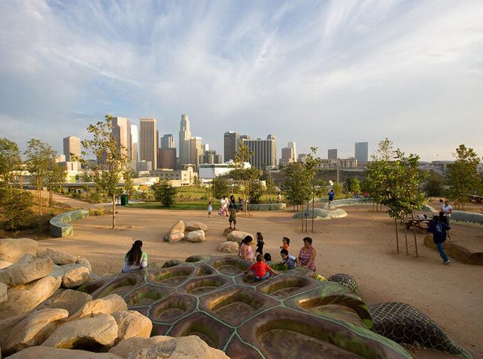

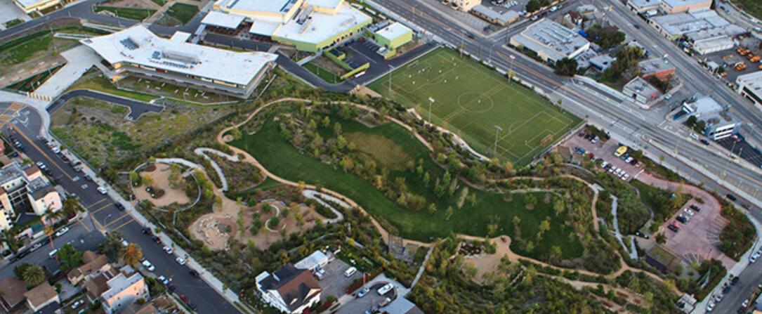
Image credit: https://assets.milestoneinternet.com/sunland-rv-resorts/siteimages/blog/san-diego-balboa-park-feat.jpg
43
Vista Hermosa site aerial.
Educational programming about the environment.
The play area featuring the spectacular LA skyline.
precedent study #3
chicago riverwalk
location: Chicago, IL
designer: Sasaki
year: 2016
Landscape Performance Series Case Study Briefs
OVERVIEW & APPLICATION
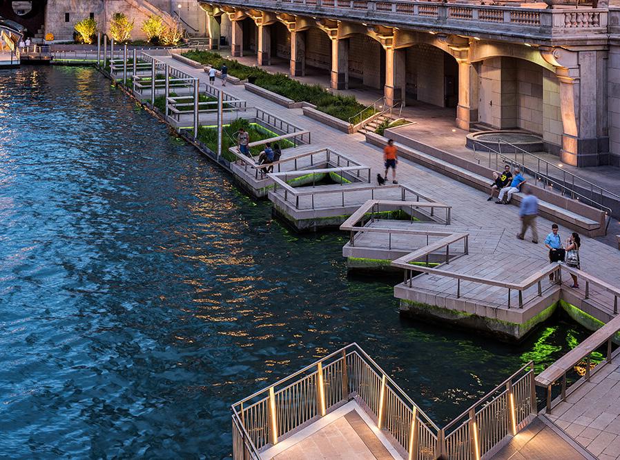
The Chicago Riverwalk is a flood-resilient, 3.5 acres project, and a six-block pedestrian promenade along the Chicago River. It provides a plethora of recreational activities and restaurants through repurposing a previously existing walkway. The redesign allows pedestrians and bikers a clear path to navigate through the series of underbridge connections while evoking an affinity with the waterway. A special feature, known as the Jetty focuses on environmental education and recreation with floating wetlands. Ballona Creek
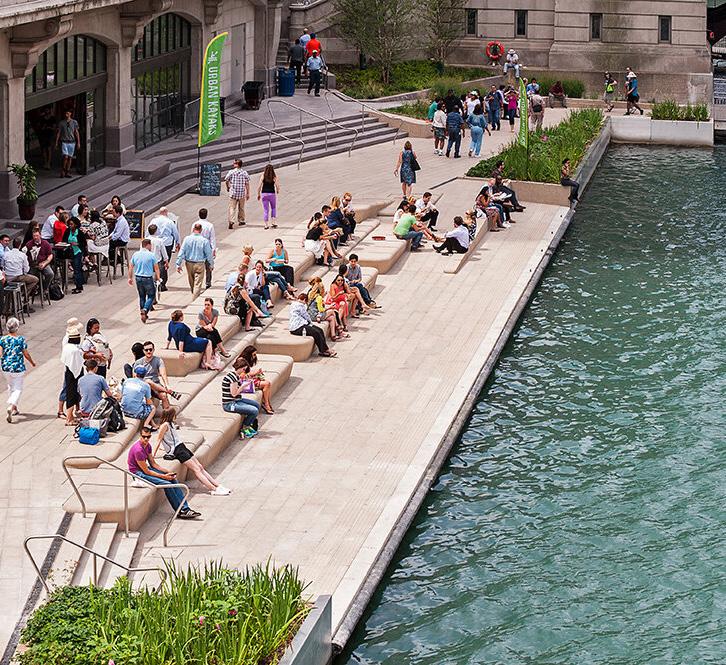
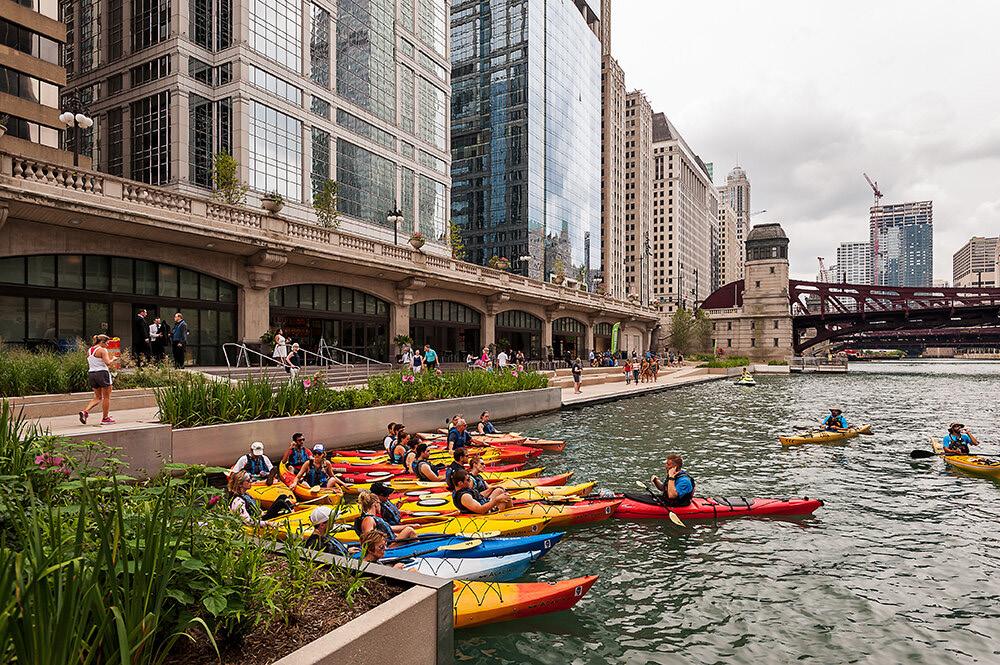
could benefit from a similar approach as urban inundation remains a considerable threat in LA. Creating more opportunities for public engagement with the creek can foster new green spaces and unique experiences for visitors. Although the scale is much larger, a similar framework of pedestrian promenades and stormwater management would create an identity for Ballona Creek.

44
The Cove, closest to the water level provides an intimacy with the river.
The floating wetlands diagram designed to provide habitat for wildlife.
The Cove is a key area for kayak rentals on the riverwalk.
Environmental benefits for consideration:
• increases the ecological quality according the Floristic Quality Index from 0 to 38.2 in the area of 19,529 sf
• considered to be a “natural area”
Social benefits for consideration:
• attracts roughly 780 visitors on summer weekends
• provide venues for Chicago Park District public programming events
• increases the satisfaction of the river
Economic benefits for consideration:
• generated over $12 million in funding for the redevelopment of earlier phases
• supports investment in public art
• created 170 new seasonal, 125 parttime, and 66 permanent jobs

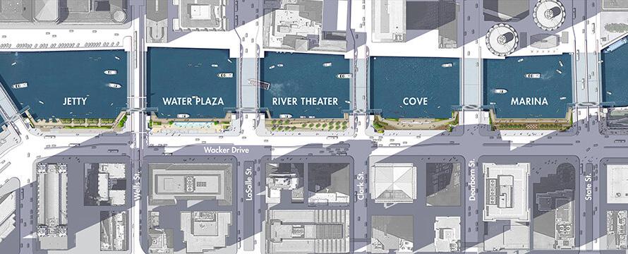
Site plan of phases 2 & 3 of the Chicago Riverwalk redeveloped the corridor from State Street to Franklin Street. Image credit: https://www.landscapeperformance.org/sites/default/files/styles/lightbox/public/Riverwalk-%20SitePlan.jpg?itok=s3hg-ru9
45
The temporary flooding of floating wetlands
Suspended walkways increasing usable space
precedent study #4
cheonggyecheon stream
location: Seoul, South Korea
designer: SeoAhn Total Landscape year: 2005
Landscape Performance Series Case Study Briefs
OVERVIEW & APPLICATION
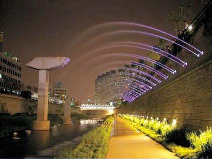
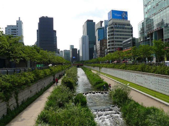
The City of Seoul has shifted from an auto-centric development-oriented urban landscape to one that values the quality of life for its people and the importance of natural systems. After the demolition of an elevated freeway to uncover a portion of the historic Cheonggyecheon Stream, the restoration project created many recreational and ecological opportunities along the 3.6-mile corridor in the heart of Seoul. The project has proven effective in attracting many visitors and providing relief within the dense urban city. This

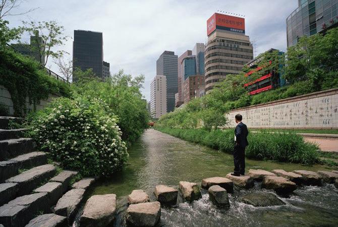
project reflects the importance of considering the needs of all users from the initial planning and design phases. Groups with visual impairments and mobility challenges were overlooked, however, these populations were accommodated for through equitable elements. Terraced vertical walls give visitors access as water levels change, creating seasonal interest during inundation.

46
Unique geometry provides visitors an intimate experience with the steam. Slower flowing areas or designed to better support biodiversity.
A stepping stone path intersecting the flow of the stream.
Environmental benefits for consideration:
• provides flood protection for up to a 200-year storm event
• increased biodiversity by 639%
• reduces urban heat island effect
• reduces small-particle air pollution
Social benefits for consideration:
• contributes to 15.1% increase in bus use and 3.3% in subway use
• attracts roughly 64,000 visitors per day
• tourists have contributed $1.9 million
Economic benefits for consideration:
• increased the price of land by 30-50% for properties within 50 meters
• increased the number of businesses by 3.5% in the stream vicinity and doubled the rate of business growth downtown

A conceptual site plan (2002) presented by the Research Center Director of the Seoul Development Institute. Image credit: https://www.landscapeperformance.org/sites/default/files/styles/lightbox/public/Cheonggyecheon-Site%20Plan.jpg?itok=HaY1r8dL
47
Vegetative buffers and natural stones regulate flow.
Previous remnants of the elevated freeway.
precedent study #5
sydney olympic millennium parklands
location: Sydney, Australia
designer: PWP Landscape Architecture year: 2000
Landscape Performance Series Case Study Briefs
OVERVIEW & APPLICATION
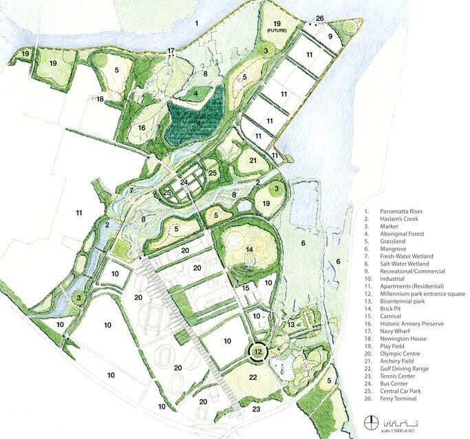
The Sydney Olympic Millennium Parklands covers an area slightly larger than New York’s Central Park and was once littered with various industrial equipment. Years of industrial activity have contaminated the soils thus the site has set a world standard for innovative techniques to remediate the large quantities of toxic materials and clean fill on site. The park uses technical water recycling systems and creates an environment in which native plants can thrive. It also reconnects Sydney’s western suburbs to one of its major waterways and

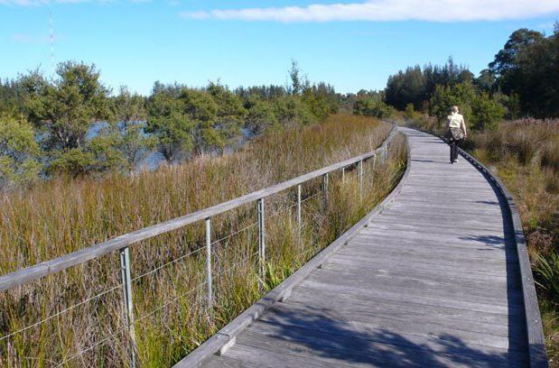
provides a plethora of recreational and educational opportunities. Most of the contaminated soils were collected and transformed into a series of protruding landforms, linear forested buffers were placed around each parkland parcel, and Haslams Creek was completely restored to a natural state. This site prompts many innovative ideas for similar applications for the future vision of the Baldwin Hills.
48
The Ring Walk, an elevated circular walkway, allows visitors to view pond. Site plan shows the importance of water and wetland areas in the site.
The boardwalk minimizes the ecological disturbances along the wetlands.
Environmental benefits for consideration:
• restored and protected more than 15 miles along the Parramatta River
• treats contaminated soils with roughly 35 megaliters of leachate collection
• provides habitats for 180+ bird species
Social benefits for consideration:
• provides different venues for recreation and leisure for roughly 2.5 million people per year
• provide educational opportunities for nearly 20,000 children annually
Economic benefits for consideration:
• enhances the economic development of the area
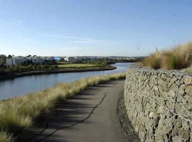
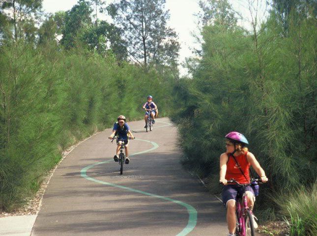
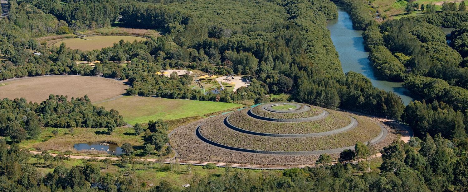
Circular landform feature with walking path orbiting up to the top. Image credit: https://www.landscapeperformance.org/sites/default/files/styles/lightbox/public/Cheonggyecheon-Site%20Plan.jpg?itok=HaY1r8dL
49
Mixed-use paths provide opportunities for bikers.
Access and views of the Parramatta River.
rhetorical questions
QUESTION #1
What is the best landscape function for the Baldwin Hills after the abandonment and withdrawal of oil wells?
QUESTION #2
What is the symbolic connection between Ballona Creek and the Baldwin Hills and what typologies are optimal for a successful corridor between the two features?
QUESTION #6
Taking inspiration from the One Big Park proposal from 2002, how can we make this place for the people of Los Angeles while also implementing restorative strategies?
QUESTION #7
What is the ideal balance of recreation, habitats, and urban facilities knowing businesses want to continue development on the Baldwin Hills?
QUESTION #3
How can the project tie the rich cultural history of Baldwin Hill’s African American residents into the design process?
QUESTION #4
What are some alternative energy generation solutions that can play into the unique topography of the Baldwin Hills?
QUESTION #8
What will happen to our oil fields once we have extracted all its finite resources?
QUESTION #5
How can we utilize this underdeveloped portion of LA as a catalyst for further park connections?
QUESTION #9
How do we connect the existing parks in the surrounding area through an immersive landscape full of public amenities?
QUESTION #10
Due to the development on both sides of Ballona Creek, how can we integrate new programs for the community?
50
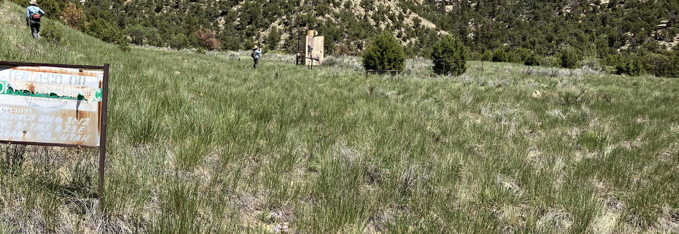
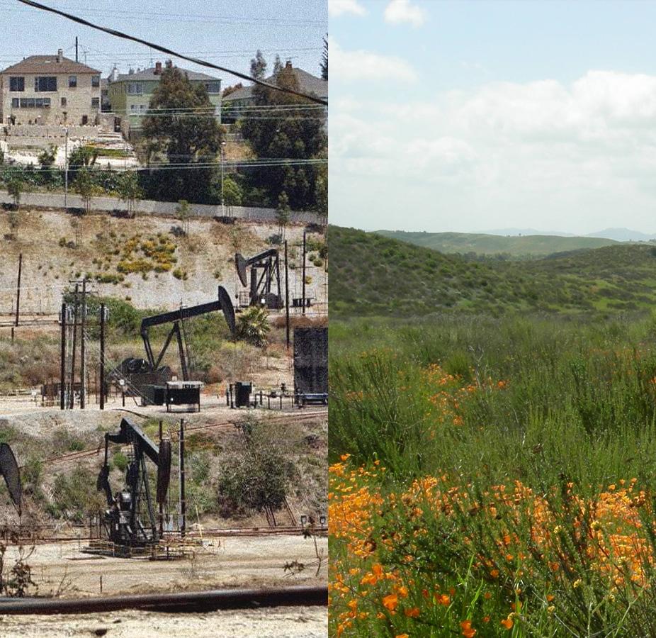
what do we do with “zombie wells”?
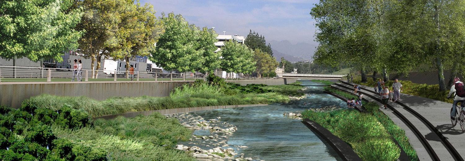
what does a naturalized creek look like?
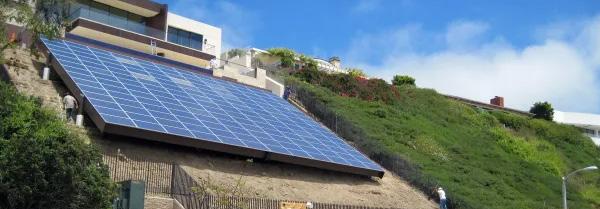
is there potential for food or energy generation?
51
dilemma-thesis statements
DILEMMA #1
As LA City and LA County begin phasing out existing oil drilling, the Baldwin Hills will become littered with oil well remnants containing toxic contaminants including chemicals, heavy metals, and petroleum by-products. How can design remediate this landscape for public use?
THESIS
Through examination of the most critically polluted areas, design practices such as phytoremediation, biological soil crust rehabilitation, landform creation & contouring, and topsoil salvaging can reclaim the landscape for alternative functions. Integrating user programs can foster an urban oasis of recreation and respite for the surrounding neighborhoods. The unique topography provides opportunities for meandering trails and rare panoramic views of the city.
DILEMMA #2
Baldwin Hills is the last undeveloped open space in Los Angeles that serves as a home to a myriad of different parks, however, Ballona Creek runs adjacent to the hills and remains disconnected from the landscape. The creek characterized by its urbanized concrete forms is plagued with pollution and lacks public accessibility. How can design address these issues while seamlessly connecting both natural features?
THESIS
Developing a naturalized corridor between Baldwin Hills and Ballona Creek can alleviate the stresses of native fauna in the area while garnering locals and tourists to an attractive landscape. A new vision for Ballona Creek can encompass innovative solutions that adapt to flooding, filter stormwater runoff, provide recreation to visitors, etc. The geometry of the creek can cater to these criteria and a design framework can further connect the city through its natural features.
DILEMMA #3
As landscape architecture shifts to a higher advocacy role, how can design address the social equity issues related to oil energy landscapes and provide visibility to alternative methods of energy generation?
THESIS
The investment in transforming the imminent orphaned oil wells on Baldwin Hills will produce greater returns in crop production, improved human health, cleaner air and water, and an ecologically sound landscape for the community. Instead of erasing the history of the site, a layer of education can become embedded into the design through signage, alternative energy programs, and edible gardens. Thus, it can reveal the invisibilities within the landscape broadening its holistic evolution.
52
six-word memoir
CONVERTING EXPLOITED LANDSCAPES INTO URBAN SANCTUARIES

53
references + resources
The following chapter consists of an annotated bibliography highlighting all the resources used during the initial research, multiple professional contacts that can facilitate the design process, and a preliminary timeline to establish milestones up until the final presentation.
Note, this information is due to change as I continue to develop the project.
54
Annotated Bibliography Professional Contacts Project Timeline 56-61 62 63
55
annotated bibliography
mla format
“About - Sustainability.” Balboa Park, 21 Aug. 2023, balboapark.org/balboa-parksustainability/#:~:text=As%20a%20result%2C%20over%20100,vehicles%20driven%20for%20a%20year.
This websites provides quantifyable sustainable performance of Balboa Park to determine its environmental impact to the surrounding area. Measurable performance benefits will become an important aspect in the project vision.
“Architecture Review: What Should a Big-City Park Look Like?” Los Angeles Times, Los Angeles Times, 23 Apr. 2009, www.latimes.com/archives/blogs/culture-monster-blog/story/2009-04-23/architecture-reviewwhat-should-a-big-city-park-look-like.
This article investigates how to successfully implement a large-scale urban park in Los Angeles. Park development in LA is extremely difficult due to the density of residential and industrial zones.
Briscoe, Tony. “Could Culver City’s Landmark Deal to End Oil Production Be a Model for Other Cities?” Los Angeles Times, Los Angeles Times, 16 Dec. 2023, www.latimes.com/environment/story/2023-12-16/culvercity-deal-to-end-oil-production-could-be-a-model.
This article addresses the new deal that Culver City and Sentinel Peak Resources have agreed upon to ban oil drilling in the city’s portion of the Inglewood oil field. This can provide incentive for other cities to shift towards a more environmentally focused agenda.
Bowker, M.A. (2007), Biological Soil Crust Rehabilitation in Theory and Practice: An Underexploited Opportunity. Restoration Ecology, 15: 13-23. https://doi.org/10.1111/j.1526-100X.2006.00185.x
This journal article explores the characteristic of soil crusts and their potential use in restorative landscapes. The author explicitly states that studies associated with BSC are limited and they play a crucial role in understanding plant succession.
Bureau, United States Census. “Explore Census Data.” Explore Census Data, data.census.gov/. Accessed 28 May 2024.
The US Census data provides demographic data for the 4 major cities/neighborhoods surrounding the Baldwin Hills. This information is helpful when implementing programs elements.
California, State of. Baldwin Hills Conservancy, 1014, bhc.ca.gov/.
The Baldwin Hills Conservancy website hosts a wealth of information about the current state of the Baldwin Hills and the optimistic vision of its future. I have only touched the surface of this website and will continue to extract as more information I can from this organization.
Cerra, Julie Lugo. “Short History.” Ballona Creek Renaissance, ballonacreek.org/history/#:~:text=The%20 creek%20collected%20the%20water,watercress%20growing%20at%20its%20edge. Accessed 28 May 2024.
This short blog explains the history of the Ballona Creek before it underwent major industrial renovations. It once was a natural creek that was home to many native trees and wildlife.
56
“City of San Diego Official Website.” Balboa Park | City of San Diego Official Website, 2024, www. sandiego.gov/park-and-recreation/parks/regional/balboa#:~:text=Balboa%20Park%20is%20made%20 up,educational%20and%20recreational%20for%20everyone.
The official Balboa Park website provides all the information about the park and its impact on the community. It displays the myriad of amenities the park harbors and the timeline of the park’s development.
Community Conservancy International. “Baldwin Hills Park Master Plan.” May 2002.
The ambitious Baldwin Hills Park Master Plan is a revolutionary vision of the landscape of the Baldwin Hills. This document has an extensive amount of information about the site and will support further research. It has grand ideas for park programs and remains a source of inspiration.
Egner, Lars Even, et al. “Proposing a framework for the restorative effects of nature through conditioning: Conditioned restoration theory.” International Journal of Environmental Research and Public Health, vol. 17, no. 18, 17 Sept. 2020, p. 6792, https://doi.org/10.3390/ijerph17186792.
This journal article explores the psychological effects that the exposure of natural environment has on humans. The study focuses on four significant stages (i) unconditioned restoration, unconditioned positive affective responses reliably occur in a given environment (such as in a natural setting); (ii) restorative conditioning, the positive affective responses become conditioned to the environment; (iii) conditioned restoration, subsequent exposure to the environment, in the absence of the unconditioned stimulus, retrieves the same positive affective responses; and (iv) stimulus generalization, subsequent exposure to associated environmental cues retrieves the same positive affective responses.
Fletch, David. “Flood Control Freakology.” Academia, 2008.
The author presents a unique counter-narrative in the revitalization of the LA River. The popular vision is to convert the river back to a naturalized state, however a balance between existing urban ecosystems should be preserved.
“Geology.” Baldwin Hills Nature, 14 Dec. 2016, baldwinhillsnature.bhc.ca.gov/geology/. This website highlights the geology of the Baldwin Hills and its complex configuration of rock layers. Most of the data hints at the formation of natural gas that has accumulated beneath the hills and the extraction of this natural resource.
Geosyntec, et al. “LA River Master Plan.” June 2022.
The LA River Master plan provides a holistic approach to re-imagining the function of the Los Angeles River. The 51-mile waterways meanders through countless neighborhoods thus the majority of the planning efforts are community oriented which serves as a guide for future development. The master plan will become an essential asset in developing the framework along Ballona Creek.
57
“History of Inglewood Oil Field.” Inglewood Oil Field, Sentinel Peak Resources, 14 Feb. 2020, inglewoodoilfield.com/history-future/history-inglewood-oilfield/.
This website explains the history of the Inglewood oil field, it’s appeal for oil drilling, and speculates future landscape uses. This remains a valuable reference to understand the timeline and the organizations involved in the area.
“History of Oil in Los Angeles.” STAND - LA, www.stand.la/history-of-oil-in-los-angeles. html#:~:text=Though%20conventional%20oil%20reserves%20have,often%20overlooked%20 low%2Dincome%20neighborhoods.&text=from%20an%20active%20or%20idle%20oil%20well. Accessed 28 May 2024.
STAND-LA is an environmental justice coalition aimed to end neighborhood oil drilling to protect the health and safety of Los Angelos residents. This blog provides current updates on oil drilling phase out initiatives and prompts hope for these impacted communities.
“Inglewood Oil Field.” City of Culver City, www.culvercity.org/City-Hall/Get-Involved/Inglewood-OilField#:~:text=Following%20the%20closure%20of%20a,later%20than%20December%2031%2C%202029. Accessed 28 May 2024.
This website hosted by Culver City provides the majority of background information about the Inglewood oil field and the timeline of oil drilling in the next decade.
Ireland, Corydon. “‘Landscapes of Energy.’” Harvard Gazette, 24 Nov. 2009, news.harvard.edu/gazette/ story/2009/11/landscapes-of-energy/.
This journal investigats energy’s spatial dimension introducing “new conditions of visibility” in the energy landscapes of our cities. It argues that landscapes of extraction are expressions of capitalism, a present issue of social justice.
“LA County – Inglewood Oil Field Campaign.” CleanBreak, 2024, cleanbreak.info/la-county-drilling-baldwinhills-inglewood-oil-field/.
CLEAN BREAK is a committee of the Los Angeles Chapter of the Sierra Club that advocates against oil field operations, gas drilling, fracking, and other forms of extraction in the region. They provide valuable insight on the effects of oil drilling and the political activism that will mitigate these environmental and human health impacts.
Marine Research Specialists. “Baldwin Hills Community Standards District.” Oct. 2008. The Baldwin Hills Community Standards District is a document that provides detailed guides to safely operate and disassemble oil wells. It hopes to establish clear regulations for operations and future oil drilling. This document is continuously updated to ensure proper regulations for the Inglewood oil fields.
58
Meares, Hadley. “Baldwin Hills, ‘the Black Beverly Hills’: The Life and Times of the Community.” LAist, 17 Mar. 2022, laist.com/news/la-history/baldwin-hills-the-black-beverly-hills-the-life-and-times-of-the-community. This article explains the rich African American history of the Baldwin Hills and the impacts they had on the community. It’s a compelling aspect of the surrounding area and their cultural significance should be recognized.
Moran, Matthew D. “Restoring Land around Abandoned Oil and Gas Wells Would Free up Millions of Acres of Forests, Farmlands and Grasslands.” The Conversation, 8 June 2021, theconversation.com/restoringland-around-abandoned-oil-and-gas-wells-would-free-up-millions-of-acres-of-forests-farmlands-andgrasslands-160240.
This article addresses the possibilities of domestic oil field reclamation and the potential profit the land can produce if put to good use. Restoring abandoned oil fields can remove millions of tons of carbon from the atmosphere and promote environmental benefits including increased habitats and biofiltration measures.
Olade, Mark. “It Will Cost up to $21.5 Billion to Clean up California’s Oil Sites. the Industry Won’t Make Enough Money to Pay for It.” LAist, 18 May 2023, https://laist.com/news/climate-environment/cost-ofcalifornia-oil-cleanup-exceeds-industry-profits.
This article addresses the expenses of oil field reclamation projects in California State. They claim that reclamation efforts should begin as soon as possible due to the decline of oil drilling in the next few decades.
Rahman MM, Azirun SM, Boyce AN (2013) Enhanced Accumulation of Copper and Lead in Amaranth (Amaranthus paniculatus), Indian Mustard (Brassica juncea) and Sunflower (Helianthus annuus). PLOS ONE 8(5): e62941. https://doi.org/10.1371/journal.pone.0062941.
This journal article explores the phytoextraction effectiveness of three plants species and the correlation between nitrogen their accumulation. Sunflower possess the highest phytoextraction characteristic.
Rovner, Melissa. “L.A.’s ‘Black Beverly Hills’ Still Threatened by Racist Past.” PBS SoCal, 26 Oct. 2021, www. pbssocal.org/shows/lost-la/view-park-black-beverly-hills.
This blog from a community member illustrates the importance of preserving the African American cultural heritage of the Baldwin Hills. The author shares stories about profound African American impact on the community even through decades of racism.
Stone, Erin. “County Takes Step to End Drilling at Inglewood Oil Field.” LAist, 4 Oct. 2023, laist.com/news/ climate-environment/county-takes-step-to-end-drilling-at-inglewood-oil-field.
This article addresses the most recent news about the phasing out of new and existing oil drilling on the Ingelwood oil field. This is the next step in reclaiming the land and providing the community with public green space.
59
Tawatari, Zack. “Raintree Residents Fear Possible Effects of Oil Practices.” Spectrum News, 17 July 2019, https://spectrumnews1.com/ca/la-west/news/2019/07/17/culver-city-residents-fear-inglewood-oil-fieldisn-t-safe.
This article discusses the health concerns of residents living in Culver City’s Raintree neighborhood. Longterm resident Deborah Weinrauch and others suspect the oil field’s operations may be linked to cancer and other health issues. They advocated for further regulations on oil drilling, however, the California Independent Petroleum Association defends the industry’s safety and regulatory compliance stating that there are no significant health risks from the oil field operations. The article highlights the ongoing conflict between community health concerns and industrial agencies.
Thomas, Mica. “Black Beverly Hills: A Community like No Other.” Medium, Medium, 9 Sept. 2021, micathomas-633.medium.com/black-beverly-hills-a-community-like-no-other-1c3c3b737d92.
This blog reflects the author’s experiences living in various neighborhoods including View Park, Baldwin Hills, and Ladera Heights. The author explains the rich African American culture of these neighborhoods, the impact of gentrification, and the importance of community events like the African Marketplace & Drum Circle. The author also emphasizes the challenge of preserving cultural heritage amid a climate of changing demographics and economic pressures.
Witt, Emily. “The End of Oil Drilling in L.A.” The New Yorker, 3 Mar. 2022, www.newyorker.com/news/letterfrom-los-angeles/the-end-of-oil-drilling-in-la.
This article provides a glimpse into what the future may hold in terms of energy production in Los Angeles. The new wave of oil phase-out legislation could change the paradigm of these polluting industries and reclaim land back to Angelenos.
60
61
professional contacts
David F. McNeill
Executive Officer | Baldwin Hills Conservancy
Studio-MLA
Landscape architecture firm located in LA & SF
Esther Margulies
Professor of landscape architecture + urbanism | USC
David Budy
Environmental Health & Safety Manager | Sentinel Peak Resources
Ballona Creek Renaissance
Non-profit organization dedicated to facilitating the long-term renewal of Ballona Creek
62
project timeline
feedback revisions additional resource gathering site documentation & organization reach out to contacts for review collect as much data for further research
inventory & analysis design ideation development develop a strong design concept finish overall master plan finalize focus areas & framework
job search/hunt evaluate project trajectory community outreach finalize design details start organizing all files
further expand and refine design development start producing graphics for design representation brainstorm innovative ways to showcase design create a portfolio and presentation poster complete final deliverables and present the project
63
date date month month june dec
july aug jan sep oct feb nov dec mar 12 6 6 23 6 15 proposal deadline end of fall quarter start of fall quarter start of winter quarter end of fall quarter senior show
The following chapter provides insight into my personal connection with the project and the goals and aspirations for my future career. My resume is also included.
64
contact
Cover Letter Resume 66 67
65

Born and raised in Washington State, I’ve had the privilege to grow up in a landscape dominated by public parks, open green space, lakes, etc. and I quickly developed an affinity for nature and water as these were the elements I spent most of my childhood in. My journey of becoming a landscape architecture student was rooted in my passion for environmental stewardship. I began university in the environmental management and protection program, yet immediately switched my major because I wanted further creativity and a hands-on approach to develop mitigation efforts against our current climate issues. As stated above, the amenities I had access to are some of the many that remain absent in our most densely populated cities, and it’s a collective effort as a community to ensure that the people in most dire need have access to these essentials. My capstone project hopes to advance this narrative to reclaim our exploited landscapes and give them back to our communities. Our relationship with natural systems and our innate biophilic tendencies are an essential condition to foster a future of resiliency and growth. We have evolved for millenniums alongside plants and animals and just now we are forgetting our harmonious legacy.
The main topics discussed in the capstone project provide endless motivation for my goals and actions. These include the remediation of oil well pollution, the framework along Ballona Creek, and the recognition of the African American culture in the area. As I continue to explore the removal of oil wells on the Baldwin Hills, I hope to define a precedent for oil field remediation. As a finite natural resource, oil fields across the world will face a challenging change in their landscape use. With environmental adaptation and mitigation in mind, we can convert these degraded landscapes into beautiful public green spaces for all.
I hope my work will foster multifunctional environments within urban systems that will advocate for positive change and inspire future generations. To achieve this goal, I plan on working at a large-scale firm that cultivates an extensive domestic and international network where I can observe different cultures, lifestyles, and narratives. This accumulation of knowledge and expertise may prompt my inclination to acquire a graduate degree. I want to become a licensed landscape architect within 3-5 years of professional experience and test for LEED AP BD+C. I have a strong passion for creating a healthier and more equitable world, therefore design is my tool for policy change and advocacy.
Thank you,
Ayver Libes

66
ayver libes
ayverlibes@gmail.com
206.948.7737
linkedin.com/in/ayverlibes
EDUCATION
EXPERIENCE
SKILLS
PERSONAL
California Polytechnic State University, San Luis Obispo San Luis Obispo, CA | September 2020 - June 2025
• Bachelor of Landscape Architecture
• President’s List & Dean’s Honor List (2020-2023)
• BMLA Landscape Architecture Shadowship (2023)
• LADAC Scholarship (2024)
Intern, Fischer Bouma Partnership
Bainbridge Island, WA | June 2023 - September 2023
• Aided the office with Photoshop, Illustrator, InDesign, AutoCAD, and Lumion production
• Worked with other disciplines to create a Lumion marketing flythrough video based on our client’s vision
• Expanded my understanding of project workflow from contract to post-occupancy evaluation
Landscaper, Wacky Nut Farm
Bainbridge Island, WA | April 2019 - September 2022
• Managed and completed various landscaping labor projects
• Planting, hardscape, and irrigation labor
Adobe Suite
Photoshop
Illustrator
InDesign
Bridge Lightroom
Premiere Pro
Drafting
AutoCAD
Land F/X
Sketching
Model Making
Sigma Lambda Alpha 2024 - present
3D Modeling
Rhino 7
SketchUp
Student ASLA 2022 - present
Cal Poly Surf Club 2022 Kappa Sigma 2020 - 2023
Visualization
Lumion
Twinmotion
Guayaki Ambassador 2022 - present
67


