

INITIATIVE Rivers Avenue Connectivity Study | North Charleston, South Carolina Final Draft 2020
BROWNFIELDS AREA-WIDE PLANNING

This plan was prepared for:
Kathryn Basha Berkeley Charleston Dorchester Council of Governments
Joel Evans
Andrea Melocik
Dan Frazier
Charleston County
Charleston County
Charleston County
Adam MacConnell City of North Charleston
Gwen Moultrie City of North Charleston
Jacob Lindsey City of Charleston
Christopher Morgan City of Charleston
Mark Berenbrok SCDHEC, Brownfields and Dry Cleaning Programs
Bryan Cordell The Sustainability Institute
Rev. Bill Stanfield Metanoia
The Rivers Avenue Connectivity Study is funded through the Brownfield Area-Wide Planning Grant from the Department of the United States Environmental Protection Agency. It would not be possible without the combined efforts and support from individuals representing BerkeleyCharleston-Dorchester Council of Governments, the City of North Charleston, and numerous community members and leaders from the Rivers Avenue area.
Duncan Cheney Metanoia
Omar Muhammad Low Country Alliance for Model Communities
Anna Lewin SC Community Loan Fund
Derek Street US EPA Region 4 Resource Conservation and Restoration Division
Ray Greer Project Manager, Stantec
Jenny Horne Asst. Project Manager, Stantec
Amanda Morrell Urban Designer,Planning, Stantec
Crystal Aponte Urban Designer, Stantec
Ian Duncan Urban Designer, Stantec
Wade Alexander Concept Designer, Stantec
Blake Thomas Concept Designer, Stantec
Jamie Hairfield Concept Designer, Stantec
Ashley Thompson Urban Designer, Stantec
Taylor Schenker Concept Designer, City of North Charleston/Clemson
Reggie Reeeves Environmental- GEL Engineering
Sarah Woodworth Market Analysis - W-ZHA, LLC
In 2017, The Berkeley, Charleston, Dorchester Council of Governments (BCDCOG) was awarded an Environmental Protection Agency (EPA) Brownfields Area-Wide Planning (BF AWP) Program grant. The BF AWP Program was created to assist the Cities of Charleston, North Charleston and Charleston County in responding to local brownfields challenges identified in the regions “Neck Area”, especially where multiple brownfield sites are in close proximity, connected by infrastructure, and overall limit the economic, environmental, and social prosperity of their surroundings.
Through the program, the EPA aids community brownfield revitalization efforts and is a part of the Partnership for Sustainable Communities collaboration among the EPA, the Department of Transportation, and the Department of Housing and Urban Development. The program assists communities by helping to perform the research needed to develop an area-wide plan for brownfields assessment, cleanup, and reuse.
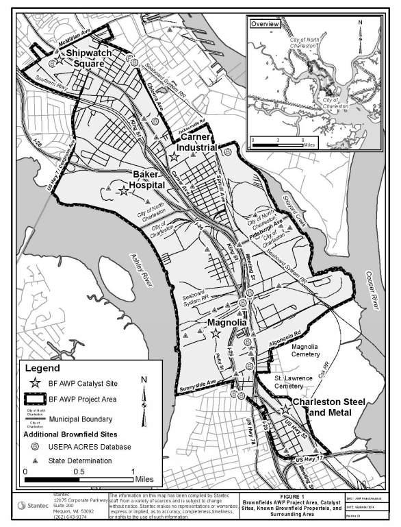
The BF AWP project area focused on a 4.3 square mile corridor in the Neck Area which included five key catalyst brownfield sites: Baker Hospital, Shipwatch Square, Carner Industrial, Magnolia and Charleston Steel and Metal. As the work plan was being developed, it was noted that four of the five identified key catalyst sites were either under construction or being planned/developed by others and it was recommended that new focus sites be identified within the BF AWP Project Area.
In August of 2018, Stantec’s consulting services were retained by BCDCOG to complete this planning work.
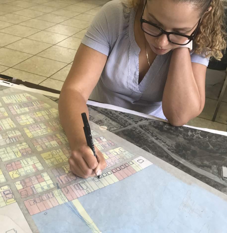
BCDCOG , the Advisory Committee and Stantec reviewed and discussed potential areas within the approved BF AWP Project Area to identify new key focus sites. With multiple planning and development initiatives occurring in the Neck Area, such as the future Bus Rapid Transit (BRT) corridor along Rivers Avenue, it was determined that our focus sites should be concentrated within the Rivers Avenue Corridor due to the impacts that the future BRT will most certainly have on adjacent properties and the community.
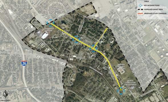
The planning corridor focuses on Rivers Avenue running south from its intersection with McMilllan Avenue to where it crosses over the Southern Railway and where Carner Avenue intersects with Burton Lane. The corridor includes four key intersections, as well as Reynolds Avenue between Meeting Street and Spruill Avenues. While Charleston County government does own several key properties and provides various services within the planning corridor, all properties are within the jurisdiction of North Charleston.
Several properties of the Rivers Avenue corridor have been identified for revitalization or redevelopment. Such redevelopment of this scale is not easy or quick. The Action Plan developed as part of this study will provide recommendations and direction - some small, some largethat can be implemented immediately or over the next many
This study will identify existing conditions in the project area, previous and current local/regional planning efforts, potential barriers to redevelopment, and examine the redevelopment potential of the brownfield sites along with overall neighborhood connectivity and amenities.
THIS PAGE WAS INTENTIONALLY LEFT BLANK
2.1 INTRODUCTION
2.2 PRIOR EFFORTS
2.3 PHYSICAL CONDITIONS
2.4 PLANNING CORRIDOR ACCESSIBILITY
2.5 BROWNFIELDS IN PLANNING CORRIDOR
2.6 MARKET RESEARCH
The Berkeley-Charleston-Dorchester Council of Governments (BCDCOG) was awarded a Brownfields Area-Wide Planning Grant in 2017 from the Environmental Protection Agency (EPA). The original area of consideration approved within the EPA grant is larger than the planning corridor being considered for this specific effort. Several original catalyst sites had been purchased by developers or other entities and therefore were no longer relevant to evaluate through this planning effort. The grant funds have been utilized to study a mile-long section of Rivers Avenue and cross-streets including Reynolds Avenue in North Charleston where multiple brownfield properties exist. Brownfield contamination in this area is compounded by other economic and social issues which will need to be addressed to ensure a successful path forward.
The multi-disciplinary team led by Stantec, has examined the redevelopment potential of the brownfield sites throughout the planning corridor. The Lowcountry Rapid Transit system is planned as a 26-mile bus route between Summerville and Charleston. The system is slated to travel in a central median along Rivers Avenue by 2025. A new regional rapid transit system in the area was another key consideration for choosing this particular portion of the EPA’s project area. Neighborhood connections and access to this new regional amenity will be vital along with ensuring that redevelopment does not destroy existing communities and neighborhoods.
We will highlight the more in-depth planning efforts that have been completed in the area. The brownfields have been identified and categorized based on contamination typologies; five focus sites have been identified and detailed recommendations for clean-up and redevelopment have been provided. The five chosen focus sites will be reviewed in greater detail in chapter 6 of this report. The existing conditions in the planning corridor will be reviewed such as building conditions, land use, zoning, walkability/bikeability and other accessibility issues. The market analysis and recommendations will also be provided which informed the physical concept designs provided in focus areas along the corridor.

When starting this effort it was important for the team to understand both previous and current studies that have been completed. The following efforts were reviewed in order to gain an understanding of the planning corridor and the observations/recommendations that have been investigated in the past.
This study’s area of focus included seven blighted City of North Charleston neighborhoods. Some of these neighborhoods, more specifically the Chicora/Cherokee, Accabee and Five Mile neighborhoods, are within our planning corridor. The plan chose a number of locations that could potentially serve as “model development blocks”. A “model development block” is a strategically selected block within a neighborhood that is then redeveloped in a way that maintains the housing character of the area and demonstrates the significance and value of potential development for the neighborhood as a whole.
The three goals were as follows:
• Preserving existing housing stock
• Catalyzing development and complete within the short term
• Assisting in stabilizing the housing stock by encouraging reinvestment
Other key components of this plan are:
Roadway Improvements:
• Creating an access roadway that would connect the port to I-26
• Creating an access boulevard that would connect local streets to the access roadway and I-26
• Reworking and revitalizing Stromboli Avenue by way of streetscape and roadway enhancements
• Implementing streetscape enhancements for parts of Carner and Spruill Avenues as well
Stromboli Avenue Corridor Concept:
• Planning a mixed-use area that would include retail development, mixed-use development, single family housing, townhomes, a community park, a recreation center with pool, office space, community services and adaptive reuse of the GEX facility
Green Space Network:
• Proposing the creation of Chicora Tank Farm (which the City of North Charleston has developed into a sport field and open space with more planned facilities to come, is between Chicora Elementary and the new fire station), Stromboli Corridor (the community park mentioned above), bike/pedestrian paths, trails along the rail, connections to the rivers and proposed buffers.
Economic Development Projects:
• Proposing a mixed-use development at the Shipwatch Square property that would include a grocery store
• Assisting local/disadvantaged vendors
• Developing a cultural tourism market in the area
Buffers:
• Creating buffers around electrical substations, commercial/industrial uses and railways with either art piece wall structures, vegetative buffers or a combination of those options
Zoning Recommendations:
• Buffering heavy industrial and transitional uses
• Ensuring that land uses in neighborhoods provide a cohesive flow - avoiding spot zoning, providing opportunity/encouragement for green/open space and establish guiding principles that new development will blend with existing neighborhood character/structure
• Ensuring that zoning allows for use of even smaller lots that with the current zoning would be ineligible for development
The study area for the Partnership for Prosperity was more in line, size wise, with the original project area approved by the EPA for the current grant. This plan is described as a “transportation and development framework,” that is to guide both public and private investments in ways that are beneficial to the focus area both in cost efficiency and in consideration for its inhabitants. The goals that this study set forth are as follows:
• Strengthen existing neighborhoods
• Solidify the area’s economic vitality
• Attract new development that helps expand housing and travel choices
There are several key accessibility/walkability/bikeability recommendations in this study. Future transit opportunities
and transit corridors for the region were identified including the bus rapid transit system. Other important items included the need for unified, cohesive and functional bikeways, pedestrian ways and freight/truck routes that work together as a series of networks to ensure safety for all user groups and efficiency of movement for all.
This plan created guidelines for the economic growth of the area. In addition, the plan explains how implementing revitalization strategies and creating more interconnected open space provides access to all. Environmental sustainability was also a focus of this study with the goals of transforming brownfield sites to usable developments, improving stormwater management, expanding natural areas and implementing buffers to separate people from certain adjacent uses.
Two of the catalyst sites chosen within this study were of particular interest to our team as they fall within or have some overlap in our planning corridor - the Stromboli Corridor Area and Shipwatch Square Area.
The recommendations for this area included low-rise (1 - 2 stories) development with the structures on the key Stromboli Avenue intersection corners of Carner Avenue and Spruill Avenue as 3 - 4 story gateway elements. The design intent was to create corridors for community activities, local services and social gathering.

The recommendations for this area were that the buildings around the core of the area, the intersection of Rivers Avenue and McMillan Avenue, be in the mid-rise range (5 - 7 stories). From this core epicenter, the buildings would scale down gradually to mid-rise (3 - 5 stories) and then reduce to low-rise (1 - 2 stories). The core of the Shipwatch Square site would be the development area around the transit system and a super stop.
This was a smaller scale effort but was still very helpful in reaching out to the community. The Better Block model is a quick study effort that lasts two to three months and culminates in a block party type event. Leading up to the event there are days of active building where people who are a part of the effort along with volunteers help create the various elements of the block party. The elements in the block party include food trucks, games, music and the like. But in this case there was also exhibits to help the community get a feel for what it would be like if their community were to be enhanced to a better physical and economic condition. These temporary improvements help the community immerse themselves in what could be and help them truly gain a vision of what potential their neighborhood has.

The Urban Land Institute (ULI) developed a panel of ten professionals in conjunction with three ULI staff members in order to carry out their study of North Charleston. The panelists and staff all have backgrounds ranging from real estate development, land use planning, financial disciplines and other similar or complementary disciplines.
The assignment that the panel was tasked with was as follows (per their final report):
• What uses or improvements in the study area would enhance and support both the Bus Rapid Transit (BRT) goals, Charleston County’s effort to establish a community services hub, the City of North Charleston’s goal to eliminate the food desert designation, and preserve the existing neighborhood’s quality of life and affordability?
• What uses or improvements in the study area may be detrimental to the surrounding neighborhoods and could contribute to displacing these communities?
• With the pending BRT line established along this corridor including an essential hub and transfer station, is there a target appropriate density/scale of development that addresses questions 1 and 2 above?
• What tools/strategies are available to help encourage
investment within the study area while minimizing or mitigating the disruption to existing neighborhoods?
• What is the cost benefit of adaptive re-use, versus demolition and new construction, as modes of redevelopment for properties in the study area?
• Understanding that properties in the study area are both government and privately owned, what role can private/ public partnerships play to achieve success of the development?
• Are public investments needed to the area’s builtenvironment such as streetscapes, bike lanes, etc.?
• How can we best involve the existing community in the study so that they have a vested interest in the outcome?
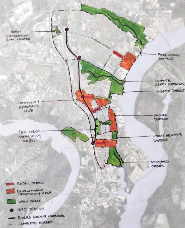
Through their study, they determined that there are four key communities within North Charleston: Park Circle District, Noisette District, Chicora District and Union Heights Districts. The areas were identified as walkable areas that serve as neighborhood gathering places, provide access to amenities and services, provide access to open space, are centers for community outreach and have connections to the broader area by way of Rivers and Spruill Avenues. They then used this “district” breakdown of the region to give potential locations for three key centers/areas:
• A Civic Center offering a range of services and amenities at a community scale located in the northern part of the region.
• A Community Resource Center with planned transit center connections and offering citywide services, higher density commercial and residential opportunities located midway in the region.
• A Community Park which would provide neighborhood level opportunities for connecting surrounding neighborhoods to open space and recreation located in the Neck area.
Other opportunities noted are creating retail streets as gathering spaces out of Reynolds Avenue, McMillan Avenue and Stromboli Avenue by way of a mix of streetscape improvements, property acquisition, rezoning to support specific beneficial uses and other similar changes. Large scale development opportunities that they noted were possibly having waterfront development at Park Circle, expansion development at the Power House in order to connect McMillan Avenue to Riverfront Park, mixed-use development at the Multi-Modal Transfer Station and mixeduse development along Stromboli Avenue at the proposed BRT station. To go along with the development, the study also sees opportunities for connecting the community open space and involving the community in the process as a whole.
The panel’s recommendations at the end of the study were as follows:
• The study area is a natural center with potential to align with all stakeholder goals, but requires an integrated approach in order to enhance the City, County and Communities goals.
• Allowing large industrial or disparate low density uses on or adjacent to any of the development sites would dilute its value and therefore would be detrimental to the goals of the various entities/stakeholders involved.
• The appropriate density/scale of development for the study area should have mid-rise density, be mixed-use, be mixed income and walkable with maximum parking requirements.
• The team recommended various tools and strategies to help encourage and guide equitable investment throughout the final report.
• The Naval Hospital building should be demolished because it is the most cost effective option for the site over adaptive re-use.
• The team recommended various ways of implementation and governance strategies to help bring the redevelopment to market.
• The area has been disinvested for far too long and therefore reinvestment and maintenance within all neighborhoods should be prioritized.
• The City and County can best engage the existing community by way of public outreach - be inclusive, open and transparent.
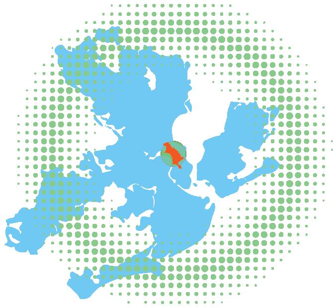
The planning corridor for this Brownfields Redevelopment Plan is found in the ‘Neck’ area of the Cities of Charleston and North Charleston, South Carolina. The Neck is a narrow piece of land that connects the peninsula housing the original boundaries of the City of Charleston to the mainland; it is bordered by the Cooper River to the east and the Ashley River to the west.
Prior to the Civil War, the area of the Neck contained small towns and farms and was a decidedly rural area. That rural character changed dramatically right after the war, however, as the area transitioned to large-scale phosphate mining operations and associated industrial railroad service lines. At the phosphate operations located between the Ashley and Cooper Rivers, soft phosphate rocks were washed, pulverized, and treated with sulfuric acid to break them down into a valuable, powdery fertilizer. These plants were abandoned at the turn of the twentieth century, leaving the cleanup to future generations.
Concurrent with the decline of the phosphate industry was the creation of the Charleston Naval Base in 1901. The arrival of the military brought new development, new jobs, and new residents to the Neck. The Naval Base also spurred the construction of new support facilities, satellite industries (such as coal and oil depots), as well as modest
neighborhoods in the traditional Neck area between the Ashley and Cooper Rivers. In addition, the area was home to industrial businesses that treated wood and smelted metals. These activities left the area contaminated with lead, arsenic, creosote, and other toxic materials. By the time of World War I the former pastures and farmland of the Neck were nearly extinct.
Neighborhoods (taken from the LAMC report and updated per our site analysis)
From the 1920s through the 1960s the Neck area saw an increase in suburbanization and development, with a public service district created to bring water, sewer, and electrical service to the area. Beginning in 1960, the City of Charleston began annexing areas north of it; with the creation of the City of North Charleston in 1972, the cities began competing to annex areas within the Neck. A number of unincorporated parcels remain today.
There have been several efforts to redevelop the Neck within the past several decades. A large-scale development, called Magnolia, was proposed in 2008. However, the crash of the real estate market shortly after its proposal stymied redevelopment plans. The area has been the subject of numerous planning efforts over the years, as described previously in this chapter.
Based on previous studies and a team driving tour, the designers noted a large amount of vacant parcels along with many derelict and abandoned structures. Much of the area is characterized by strip commercial and various industrial uses; however, a substantial amount of publicly-owned property lies within the planning corridor. Schools included the Military Magnet Academy, Chicora Elementary (both historic and new), Mary Ford Elementary and Ronald E. McNair Elementary. County and city services such as police,
fire and the Department of Social Services call southern North Charleston home.
The planning corridor has a number of churches, many of which provide social services to the area residents. Housing typologies include multi-family buildings, single family homes and mobile homes. Neighborhoods are mostly modest single family cottages in fair condition.
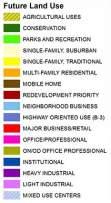
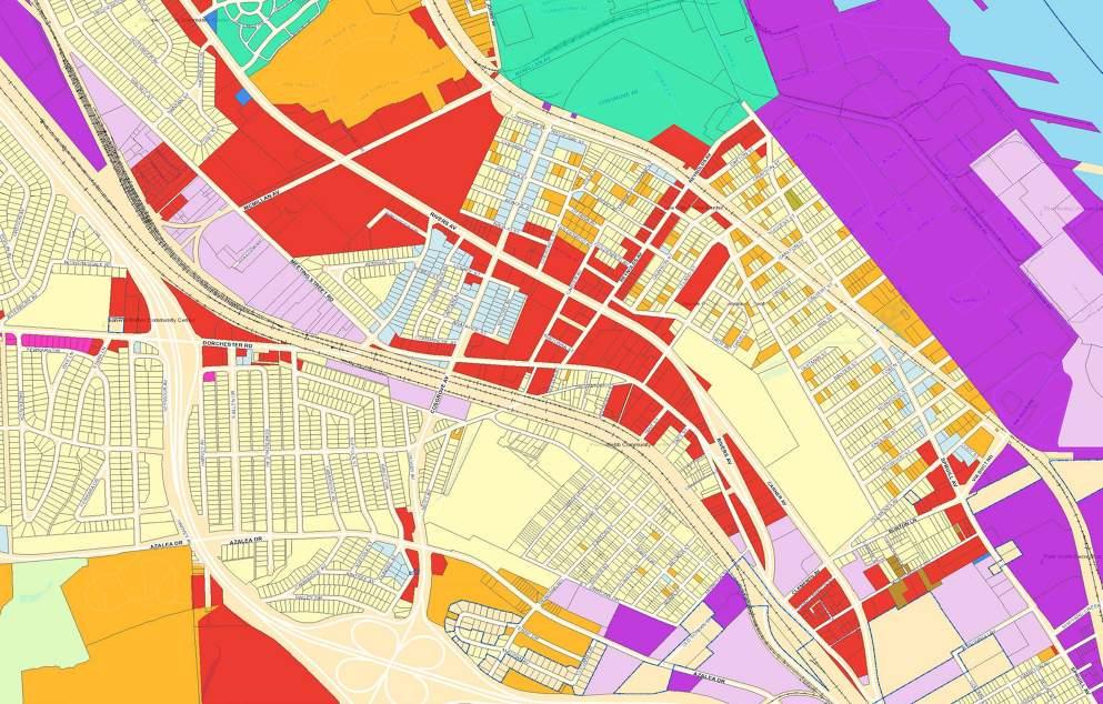
According to the City of North Charleston’s Future Land Use Map data the Shipwatch Square site and the former naval hospital site are deemed mixed-use. Many of the blocks adjacent to the former naval hospital site are also deemed mixed use although when you evaluate each parcel
The portion of the planning corridor to the SW of Rivers Avenue between McMillan Avenue and Cosgrove Avenue is a mix of light industrial, single family (traditional), major business/retail and just one parcel of parks and recreation. NW of Rivers Avenue between Cosgrove Avenue and Reynolds Avenue you find mainly single family (traditional) and multi-family residential land use with some mixed use, institutional and major business/retail scattered in. This makes sense since the residential neighborhoods were built to house workers at the Charleston Naval Shipyard.
The predominant land use types for the rest of the planning corridor from here on is major business/retail (mainly on either side of Rivers Avenue and Meeting Street Road), single family (traditional) and multi-family residential with some institutional, parks and recreation, conservation, light industrial and heavy industrial. Although the predominant land use types are major business/retail, single family (traditional) and multi-family residential in quantity, these lots are smaller residential scale lots. The institutional, parks and recreation, conservation, light industrial and heavy industrial lots tend to be large in size due to their use type.
When it comes to zoning for the planning corridor we encounter four main zoning types which are: B-1 Limited Business District, B-2 General Business District, R-1 Singlefamily Residential District and R-2 Multi-family Residential District. The three additional zoning types that we see in the planning corridor but to a lesser occurrence are: R-3 Mobile Home Residential District, M-1 Light Industrial District and M-2 Heavy Industrial District.
The purpose and explanation of the above zoning types are as follows:
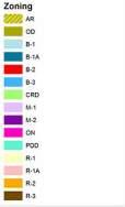
• R-1 Single-family Residential District - reserves appropriate land for medium density single-family residential uses (excluding mobile homes). It discourages any encroachment by commercial, industrial, or other use capable of adversely affecting the residential character of the district.
• R-2 Multi-family Residential District - reserves appropriate land for medium-to-high density residential purposes.
• R-3 Mobile Home Residential District - reserves appropriate land for medium density residential purposes. The term mobile home shall include trailers, mobiles homes and manufactured homes.
• B-1 Limited Business District - encourages the formation and continuance of a quiet and uncongested environment for compatible professional business offices together with certain residential and neighborhood commercial uses which will not adversely affect adjacent residential areas.
• B-2 General Business District - reserves appropriate land for general business purposes with particular
consideration for general commercial development. The applicable regulations that apply within this district encourage the formation and continuance of a compatible and economically healthy environment for business, financial, and professional service uses which benefit from being in close proximity to each other.
• M-1 Light Industrial District - provides areas for commercial, warehousing, transportation, and certain light manufacturing activities within the city.
• M-2 Heavy Industrial District - provides areas for commercial, manufacturing storage, and transportationrelated activities within the city.
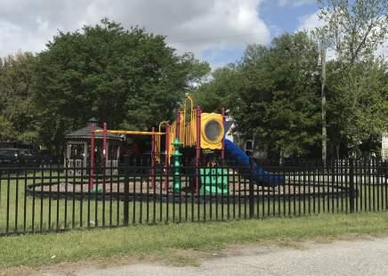
The parks within the planning corridor include Accabee Park, Whipper Barony Park and Four Poles Park. Four Poles Park is the smallest of the three and includes a small dock area for fishing. Other recreation facilities include Nafair Playground and the fields on the Military Magnet Academy’s campus. A number of community centers are found in the area and include the Gussie Green Community Center and Fresh Future Farm on Success Street and the Chicora Neighborhood Garden at Calvert Street. Other centers in the area include the Perry-Webb Community Center, the Whipper Barony Community Center and the Live Oak Senior Center.
Rivers Avenue at McMillan Avenue is a major center of our County and serves as the study areas most northern boundary and a major connecting spine to the Neck Area. The original grid system of roads remains mostly in tact offering drivers options for navigating the roadways. Dorchester Road and Cosgrove Avenue are cross streets of Rivers Avenue that can be used to access I-26 to the southwest. The Seaboard System Railway and the Southern Railway are freight lines situated between Rivers Avenue and I-26 creating a real barrier for both the Accabee Neighborhood and a portion of the light industrial space at the southern end of the study area. Public access to both the Cooper and Ashley Rivers is limited. Three public facilities are located along the Cooper River; R.M. Hendrick Park, Cooper River Marina and Riverfront Park. The Ashley River offers The Bend, a semi-public, redeveloped 20-acre open space venue, and the Future Ashley River County Park (CCPRC facility) all five are outside of the study area and are currently the only option available.
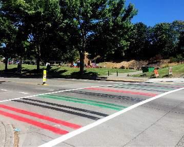
Rivers Avenue is characterized as an auto-dominated environment accessed most often by single occupant vehicles and local buses. Several uses within the study area have fencing which creates a physical barrier, particularly for pedestrians and cyclists. Inconsistent sidewalks and a lack of bicycle facilities also create a hostile walking and biking environment.
The standout access issue in the corridor and surrounding neighborhoods is related to food. The area is considered a “food desert” which is defined as an urbanized area with a lack of access to quality food at affordable prices.
Water
Generally speaking, the entire subject area is serviced by the Charleston Water System (CWS) which is a large public water supply utility for the greater Charleston area. CWS treats and distributes water from the Goose Creek Reservoir at the Hanahan Treatment Facility. From here it’s distributed throughout the Charleston Region, including North Charleston.
There are a few major primary transmission mains that supply potable water and fire protection to Historic Downtown Charleston that run through the project corridor. These transmission mains are highly important to CWS and must be protected. Locally, potable water and fire protection are provided to the study area by smaller water mains that branch from the transmission mains.
Typically, larger main lines are located along major roadways with smaller lines located along residential roadways. These smaller lines may not support redevelopment without replacement or extension of a larger water main. In addition, all water infrastructure
within this area is dated and could be reaching it’s design life.
The North Charleston Sewer District (NCSD) is the utility that is responsible for collecting and treating wastewater from the study area. NCSD collects wastewater via gravity sewer mains and directs the runoff to a series of pump stations. These pump stations send wastewater in North Charleston to the Felix C. Davis Wastewater Treatment Plant located at the end of Herbert Street, in the City of Charleston. This facility treats the wastewater before discharging the treated water into the Cooper River. Similar to the water system in the study area, the wastewater system is dated and reaching it’s design life.
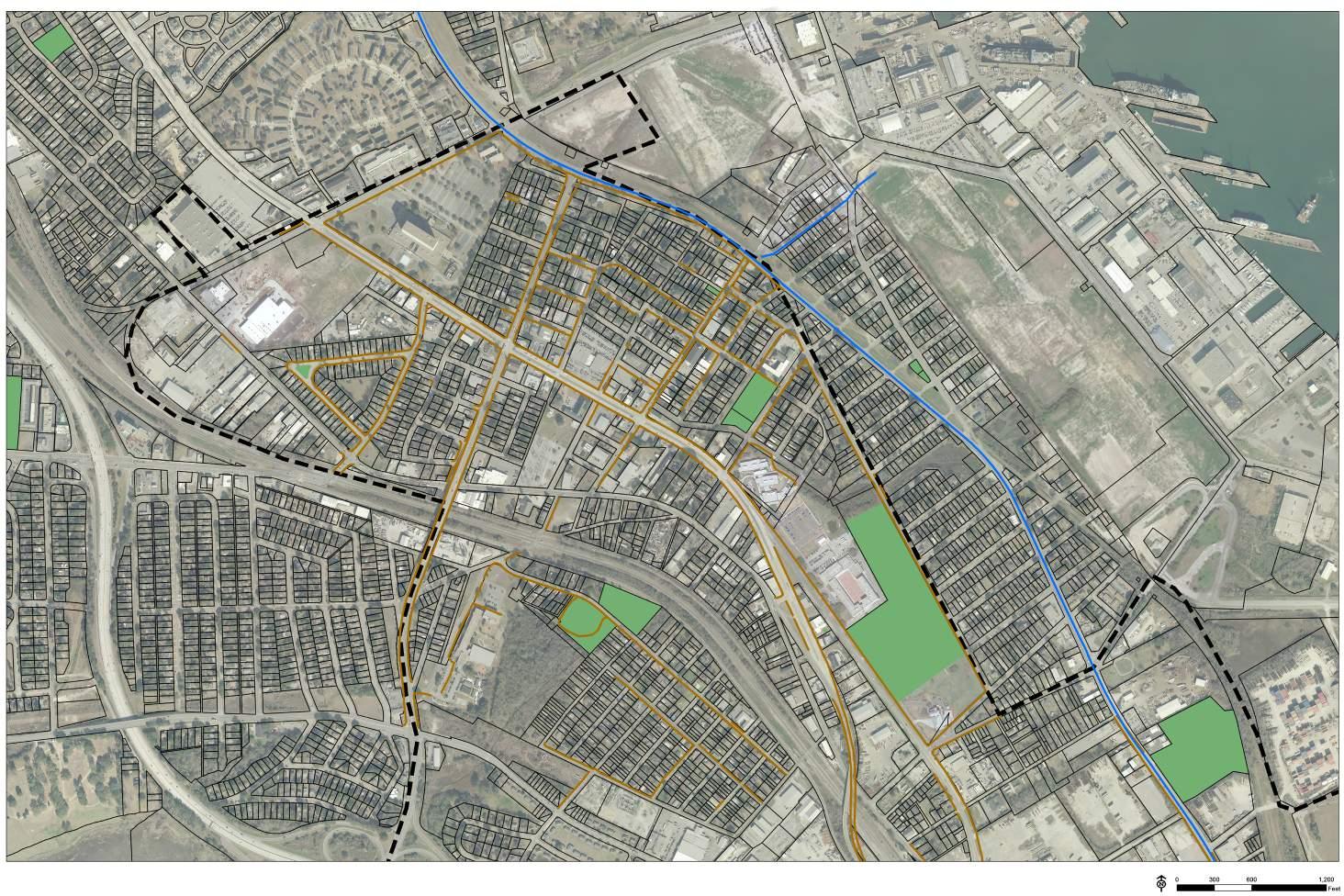
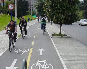
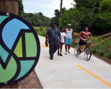
Our planning corridor lacks cohesive connectivity by way of walking and/or biking. Although the main planning corridor has sidewalks, the sidewalks on surrounding blocks are sparse and inconsistent. In order to increase access not only to the corridor but to other facilities/ amenities and resources it would be ideal to put in more sidewalks and bicycle facilities. The addition of these will help bring people to key locations such as open/green space, parks and other similar locations and areas where they can access needed services and resources.
Bikeability, Walkability, Open/Green Space, Community Centers and Parks and Recreation Map
Brownfields Area-Wide Planning Initiative
BROWNFIELDS IN PROJECT AREA
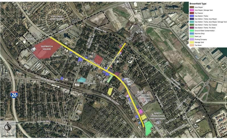
The planning corridor has about 112± identified brownfield sites; we have assigned brownfield typology information to 44 of them. The brownfield types that exist currently in the planning corridor are as follows:
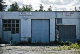
• Auto Repair
• Auto Repair, Salvage Yard
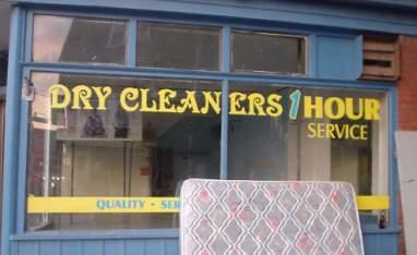
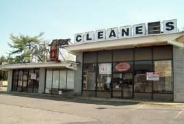
• Dry Cleaner
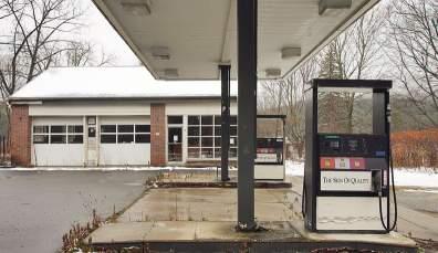
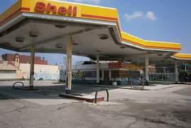
• Gas Station / Tanks
• Gas Station / Tanks, Auto Repair
• Gas Station / Tanks, Auto Repair, Salvage Yard
• Gas Station / Tanks, Dry Cleaner
• Gas Station / Tanks, Tire Store
• Ground Water Contamination
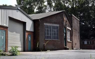
• Machine Shop
• Clandestine drug laboratory
• Printing Company
• Salvage Yard
• Tire Store
The more in-depth analysis of how these sites were studied, identified and the recommendations provided for their proper mitigation are addressed in chapters 3 and 6.
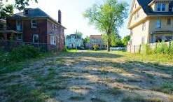
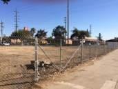
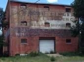
Vacant Lot and Buildings - these are known brownfield sites in the planning corridor (top)
Identified Brownfields - Historic and/or Current Brownfield Typology (bottom)
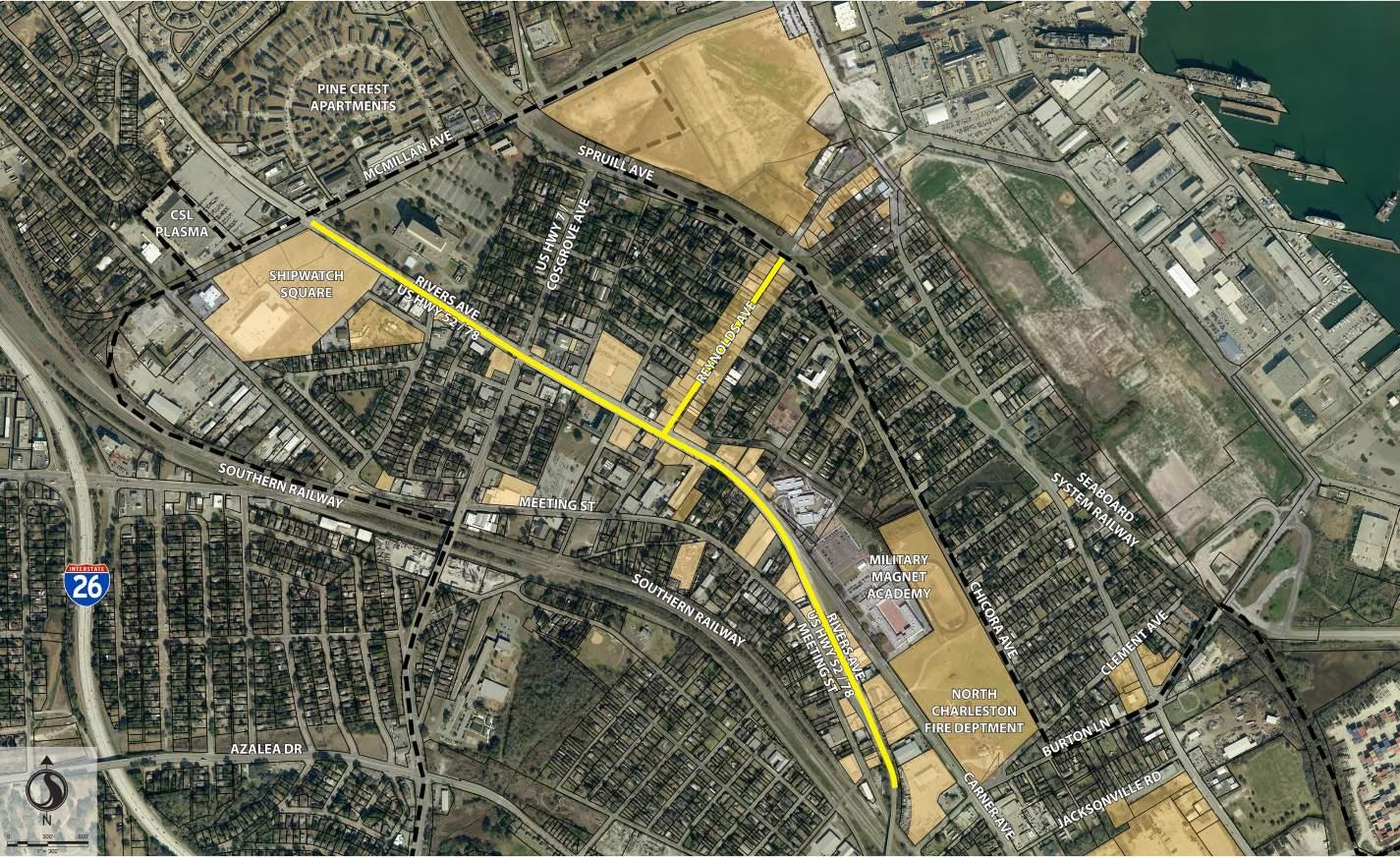
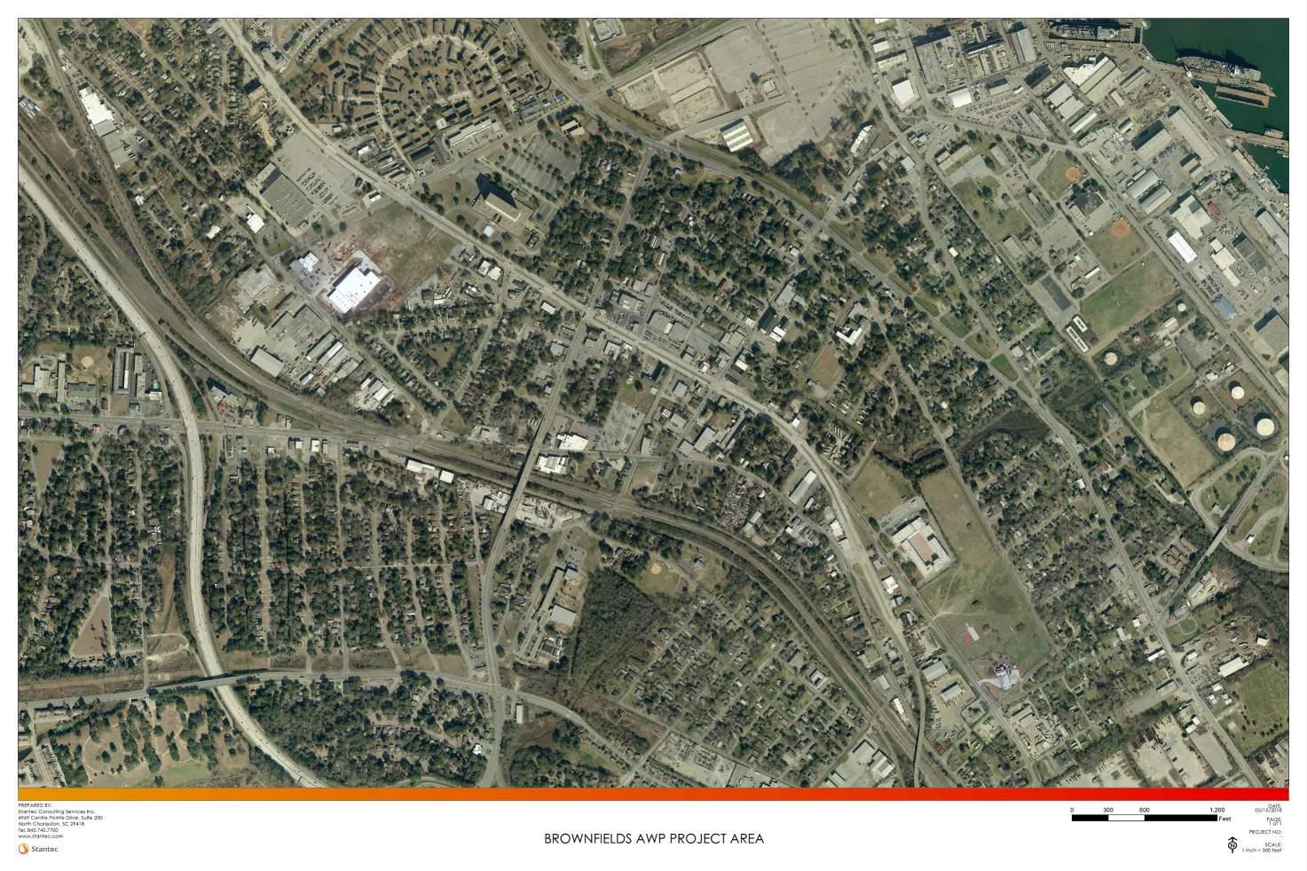
A multi-disciplinary consulting team led by Stantec was retained by the City of North Charleston to develop a Brownfield Redevelopment Plan. The Brownfield Study Area boundaries are illustrated in Figure 1 on the following page.
W-ZHA is the market and economic consultant on the Stantec Team. The following summarizes the market issues and opportunities facing the Study Area and concludes with land use recommendations.
Access
As a major north-south connector, Rivers Avenue functions as the spine to the Study Area. North of the Brownfield Study Area at Helms Avenue Rivers Avenue’s daily traffic averages 17,700 vehicles per day. In the Study Area near Reynolds Avenue traffic averages 8,900 vehicles per day. Traffic volumes in the Study Area are low for a 5-lane road. There are connections between Rivers Avenue and I-26 at Dorchester Road and Cosgrove Avenue. At the southern end of the Study Area, Rivers Avenue elevates at the Five Mile Viaduct which crosses the train tracks.
Residential is the dominant land use in the Study Area. The residential neighborhoods were built to house workers at the Charleston Naval Shipyard. The residential stock in these neighborhoods is predominantly small, single-family homes. There are some small multi-family apartment buildings as well.
Retail, restaurants, service office, institutional and light industrial land uses abut Rivers Avenue. To the north of Reynolds Avenue, Rivers Avenue land uses serve the resident and pass-by market - mostly retail, fast food, and service uses. South of Reynolds, the land uses are mostly light industrial and public/institutional.
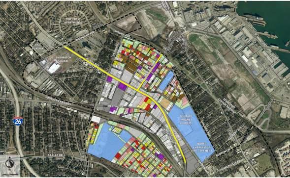
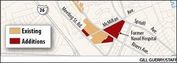
There are two large vacant land assemblages at the intersection of Rivers Avenue and McMillan Avenue. On the southeast corner is the County-owned, 22-acre former Naval Hospital site. There is a 10-story, 400,000 square foot hospital building and two 30,500 square foot dormitory buildings on the Hospital site.
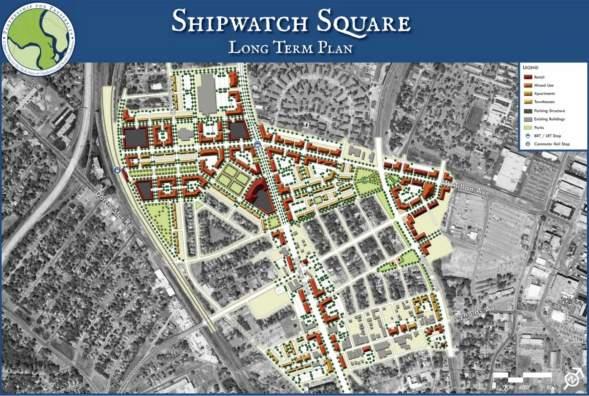
On the southwest corner of the Rivers and McMillan intersection, there is a vacant 11.5-acre site available for sale. This property is owned by a private interest and is commonly referred to as the Shipwatch Square site.
Across McMillan from the Shipwatch Square site is a large site that was once the home of a Kmart. In the old Kmart building, there is an existing laboratory/medical use that will soon be vacating the building. The parking lot associated with the building is owned separately. Adjacent to these parcels is a vacant Payless Shoe store. Combine the Kmart building, the parking lot and the Payless parcel, total acreage is approximately 10 acres. Additionally, just west of these sites is a Post Office distribution parcel.
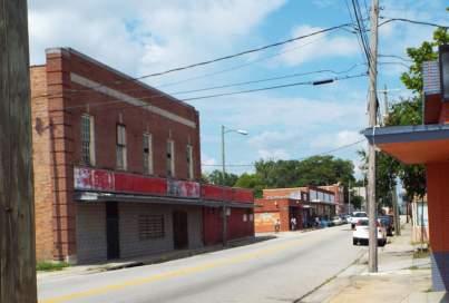
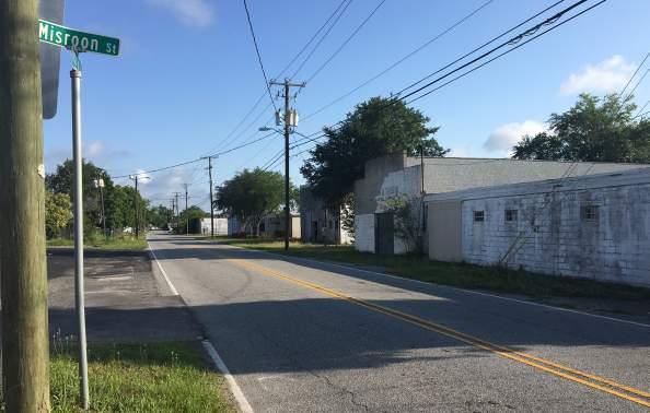
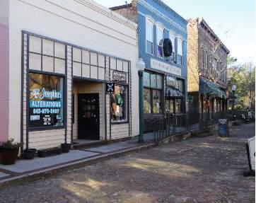
In the middle of the Brownfield Study Area is Reynolds Avenue. When the Naval Shipyard was operating, Reynolds Avenue functioned as a neighborhood center and its character reflects such. Reynolds has two travel lanes and on-street parking. Many of the buildings are built to the sidewalk which creates a cohesive building streetface. Storefronts are currently occupied by churches and other service establishments. The building streetface begins to break down at Florida Avenue proceeding east around the Spruill intersection where there are vacant lots and buildings set back from the street. East of Spruill, buildings are only on the south side of Reynolds.
The south end of the Study Area contains the relatively new Chicora Elementary School, the Military Magnet Academy, playing fields and a new City fire station. Other uses are mostly auto-service oriented and/or light industrial. There
are few goods and services available within walking distance to uses in the southern portion of the Study Area.
To the east of the Brownfield Study Area is the former Charleston Naval Shipyard. This area is being repositioned and now is home to a number of businesses. Office and light industrial space continues to be marketed for re-use. Existing employment is unknown for that portion of the Shipyard that is adjacent to the Study Area. However, there are 1,500 to 2,000 employed at CMMC on the Naval Shipyard grounds near the Study Area.
Much of the Study Area is located within an Opportunity Zone. Opportunity Zones are geographic areas within which investments may be eligible for preferential tax treatment. Properties north of McMillan Avenue and west of Spruill Avenue are not in the Opportunity Zone.
An Opportunity Fund provides funding for projects in Opportunity Zones. By investing in an Opportunity Fund, investors defer capital gains tax and may, depending on how long they stay invested, be eligible for a capital gains reduction. If investors remain in the Opportunity Fund for 10 years, all of the gains made on the initial investment are exempt from capital gains taxes. Literature suggests that
leveraging all of these tax benefits can increase investment return by 30% to 40%.
In addition to the Opportunity Zone, the large vacant and under-utilized properties at the Rivers and McMillan intersection are in a Tax Increment Financing District (TIF District). Properties within the TIF District include Shipwatch Square and the properties along Rivers to Dorchester Road; the Naval Hospital site; the Kmart/ Payless/Post Office area. TIF is used to channel incremental tax revenues toward improvements to stimulate investments where development might not otherwise occur. TIF uses the increase in property taxes that new development generates to finance qualified costs related to development. In other words, TIF is a mechanism used to capture the future tax benefits of real estate improvements to pay the present cost of the infrastructure necessary to support the improvements.
The Berkeley-Charleston-Dorchester Council of Governments is planning a Bus Rapid Transit (BRT) system. The BRT will link Downtown Charleston with Summerville
in Dorchester County. Funded by a recently passed transportation sales tax, the BRT will run in the middle of Rivers Avenue. This initial phase is expected to be complete in 6 to 8 years. The system is planned to extend to other areas of the Metro Area over time.
A BRT station is planned at the intersection of Rivers Avenue and McMillan Avenue. This station has been identified as a major transfer hub for the system. As planned, the BRT should add value to property within walking distance to its stations.
Palmetto Railways plans to construct a Navy Base Intermodal Facility on a 118-acre site just east of the Study Area. The Intermodal Facility will transfer containers moving through the Port of Charleston to freight trains. It is our understanding that the Intermodal Facility’s site will extend to McMillan Avenue and that the McMillan Avenue connection between Spruill Avenue and the Navy base will be closed. The Intermodal Facility will be a secure facility with limited public access. From a market perspective, it will function like a wall reducing the opportunities for synergy between Rivers Avenue and Naval Yard activities.
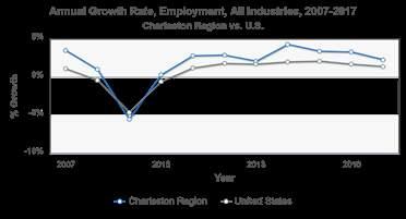
The Charleston-North Charleston-Summerville Metropolitan Area contains approximately 783,000 people. The Metropolitan Area has been growing quickly. There are 18% more people in the Metropolitan Area today than there were just eight years ago.
The City of North Charleston has experienced rapid growth as well. Since 2010, there are 17% more people residing in the City. Approximately, 114,400 people live in North Charleston today.
The American Cities Business Journal projects that the Metropolitan Area will contain approximately 980,000 people by 2030, 200,000 more residents than today. This represent 25% increase in population over the next 12 years.
The economy has expanded correspondingly with population growth. Metropolitan Area jobs increased by 27% between 2010 and 2018 according to the Bureau of Labor Statistics payroll data. According to the Charleston Region Data Center, there are approximately 372,500 employed persons in the Metropolitan Area as of April 2019. The Charleston Region’s employment growth outpaced national averages.
2018 economic and demographic data indicate that the Charleston-North Charleston Metropolitan Area population is, on average, younger, better-educated and with higher incomes than the State average. At a median of 32.8 years old, the City of North Charleston is considerably younger than the Metropolitan average of 37. North Charleston’s population has lower educational attainment and lower incomes as compared to the State and Metro averages. As a share of total housing, there are more rental units in North Charleston as compared to the Metro and the State.

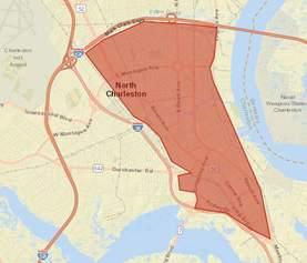
The Brownfield Study Area exists within a market area. The “Immediate Market Area” was considered to be the area east of I-26 to the Virginia Avenue/railroad tracks, south of I-526, and north of where Spruill Avenue meets Meeting Street Road. Due to Census Tract boundaries, the analytical data is limited to the east of the railroad tracks that parallel I-26.
There are approximately 18,800 people and 7,700 households residing in the Immediate Market Area. Where the Metropolitan Area and the City of North Charleston grew between 2000 and 2010, the Immediate Market Area’s population and households declined. Albeit slower than the City, the Immediate Market Area grew between 2010 and 2018.

The portion of the Immediate Market Area that is north of McMillan Avenue has fared considerably better in terms of growth than the area south of McMillan Avenue. The neighborhoods north of McMillan Avenue captured over 85% of the Immediate Market Area’s household growth between 2010 and 2018.
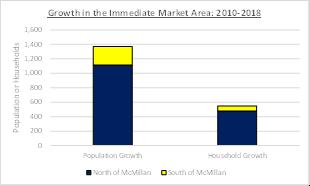
The Brownfield Study Area is south of McMillan Avenue. The Park Circle and adjacent neighborhoods have been revitalizing. Single-family and multi-family residential construction have occurred in these neighborhoods. Notable multi-family projects include the Factory at Garco, Link Apartments Mixson, and West Yard Lofts. These projects consist of 3- to 4-story buildings with surface parking. There has not been significant residential development over the last 8 years in the area south of McMillan Avenue.
The disparity between the north and south portions of the Immediate Market Area is apparent in demographic and social indicators. The residents in the area south of McMillan Avenue are younger than their northern counterparts. Median income among households south of the McMillan is two-thirds the average for households north of McMillan.
The home ownership rate is very low in the Immediate Market Area south of McMillan. In this area, 60% of the housing stock is rented and 20% is vacant. Low home ownership rates increase the risk of household displacement due to growth.
Finally, less than 10% of the households south of McMillan have bachelors degrees (or higher). With low average income, educational attainment, home ownership rates and educational attainment, the area south of McMillan fits the profile of a distressed community. These types of
communities struggle for investment and can be vulnerable to gentrification if in the path of growth.
Residential
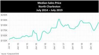
North Charleston’s rapid growth has led to housing price escalation over the last 5 years. With a projected average annual household growth rate of almost 2% per year over the next 5 years, pressure on the housing market will continue.
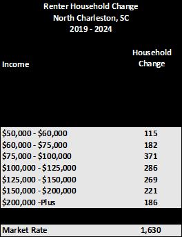
Ribbon Demographics is a company that forecasts housing demand by household type, income and tenure. Ribbon Demographics uses demographic projections calculated by Claritas, Inc., a national consumer research company. Ribbon Demographics projects that over the next 5 years there will be demand for 1,800 for-sale units and 1,759 rental units in North Charleston. Over two-thirds of the for-sale units will be for one- and two-person households.
New market-rate rental units are generally affordable to households earning $50,000-plus. Thus, of the 1,759 multifamily units demanded, 1,630 are from households that can afford new construction.
With the introduction of the Bus Rapid Transit, those areas of the Brownfield Study Area that are within walking distance to the proposed station at Rivers and McMillan
have the potential to attract residential investment. Households, particularly millennial households, value locations with transit options. To “jump start” neighborhood revitalization, targeting a critical mass of multi-family housing at the Rivers and McMillan Avenue intersection is recommended. There is vacant and/or under-utilized land at this location and because this area was once commercial/ institutional, high density development will not negatively impact existing neighborhoods. A catalyst project may be necessary to fully leverage BRT’s transformative potential.
Initial phases of development will likely be surface-parked and ideally built at a density of 30 to 40 dwelling units per acre. The City of North Charleston’s current zoning for R-2 (multi-family residential) allows for a maximum of 29 units per acre. Tax increment financing may be leveraged to fund infrastructure improvements and structured parking.
With an anchor project at the proposed BRT station stop at McMillan, it is likely that the reinvestment taking place north of McMillan will begin to move south. Housing acquisition, demolition and infill development in the Study Area’s neighborhoods will likely take place. Single family, duplex and townhouse development will occur in the neighborhoods. Larger multi-family projects should be directed to the major transportation corridors in order to
protect neighborhood integrity and scale.
With regional growth, BRT, a catalyst project and a population that predominantly rents, gentrification will be a real risk in the Brownfield Study Area. One way to protect existing neighborhood residents is through the development of affordable housing. Another approach is to create a land trust where a non-profit purchases homes in order to preserve the affordable housing stock.
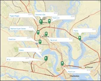
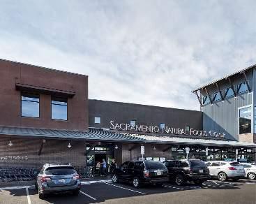
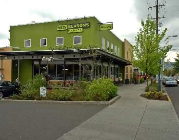
There are community shopping nodes surrounding the Brownfield Study Area. These nodes are about a 10-minute drive from the Rivers and McMillan Avenue intersection. Given that 26% of the households in the Immediate Market Area do not have access to a vehicle, these shopping nodes are not convenient to many in the area. Community shopping nodes are typically anchored by a grocery store and include goods and services to satisfy day-to-day household needs.
There is one grocery store in the Immediate Trade Area, a Save-A-Lot on Durant Avenue. According to the US Department of Agriculture, the portion of the Immediate Trade Area that is south of McMillan Avenue is classified as a “food desert”. Here food is made available in convenience stores.
There are 7,700 households in the Immediate Market Area today. There are projected to be approximately 8,300 households by 2023. There is sufficient household density to support a grocery-anchored community shopping center in the neighborhood. A logical place for a community shopping node would be near the BRT stop at the intersection of Rivers and McMillan. Here retail and services could be incorporated into mixed-use projects.
According to an interview with the Shipwatch Square property owner, there has been grocery store interest at this location. The failure to garner a store commitment has been due to the investment environment around the site. Potential grocers were not convinced that the neighborhood was poised for growth and revitalization. This points to the need for a catalyst project to transform the image and economic position of the area. Significant investment needs to be injected into the economy to fully leverage the area’s strategic location and the BRT investment.
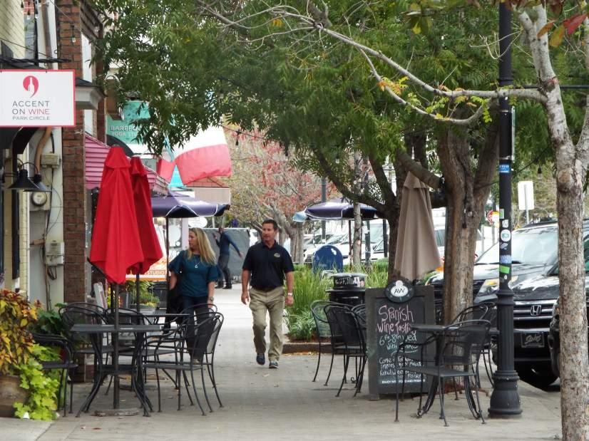
Eating and drinking potential is driven by households, income, access (traffic counts) and the presence of daytime workers. There is a cluster of restaurants in Olde Village in the East Park Circle Area. This portion of East Montague is walkable and attractive and has become a local and regional restaurant destination. The energy of East Montague
Avenue is moving south with new restaurants opening on Spruill Avenue.
The eating and drinking outlets in the remainder of the Study Area are mostly on Rivers Avenue and fast food-oriented. There are some independent eat/drink establishments on Reynolds Avenue. The challenge for eating and drinking investment in the Brownfield Study Area is that it is a low-income neighborhood and there is not a daytime worker population within easy walking distance. The Plan to close McMillan Avenue at the Naval Yard will only make access to the workers at the Naval Yard more limited.
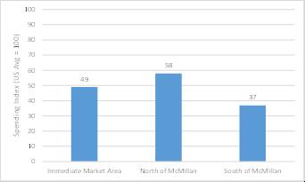
“Food away from home” spending is the amount of money spent in restaurants, take-out restaurants and fast food establishments. The food away from home spending index in the Immediate Market Area is low (Index = 49) as compared to the national average (Index = 100). As would be expected the index for the Market Area south of McMillan Avenue is particularly low at 37.
For planning purposes, retail and eat/drink uses should be clustered along Rivers Avenue between Reynolds Avenue and Helm Avenue with the center being at the Rivers and McMillan intersection. There may also be eat/drink potential along Spruill Avenue from McMillan Avenue north. Streetscape investments that improve walkability
and establish a sense of place will be very important to fostering restaurant investment. The image of this portion of the Brownfield Study Area must improve to attract neighborhood-serving businesses.
Reynolds Avenue was once a neighborhood center with shopping and restaurants. The scale of the street and continuous building streetface make it a unique place in the Study Area. There are current revitalization efforts occurring along Reynolds Avenue to return this corridor to its former vibrancy. Groups such as The Reynolds Avenue Area Merchant Association (RAAMA) have been formed to support this commercial districts revitalization efforts and to ensure that the charm of Reynolds Avenue is retained.
In the near term, however, tenants for the storefronts on Reynolds Avenue will likely be service establishments as opposed to retail and/or restaurant establishments. The immediate market around Reynolds needs to grow and strengthen before retail and restaurants can be successful. In the interim, streetscape improvements and the provision of small public parking lots on under-utilized sites can be implemented to improve the street’s functionality and attractiveness.
The Charleston office market is performing very well with
high average rents and low vacancy. According to an Avison Young Market Report for the 1st Quarter of 2019, the overall Charleston multi-tenant office market was over 94% occupied. The average full-service office rent was $33.84 per square foot.
The North Charleston office sub-market has the largest multi-tenant office inventory at 7.58 million square feet. North Charleston’s vacancy rate is low at 6.5% and its availability rate is 8.8% (also low). The City’s office supply is essentially full. There is no Class A office space in the Immediate Market Area. The office space at the Naval Yard is Class B or C.
Given the Brownfield Study Area’s central location and the proposed BRT line, it has the potential to be a good office location. The challenge is the lack of amenities in the Brownfield Study Area. Office tenants are increasingly interested in locating in places that offer a live/work/play environment for employees. Today, the Study Area does not offer quality market rate housing, goods and services, and recreational opportunities.
Thus, like retail, the opportunity to realize office potential will depend upon a significant “catalyst” project that changes the Study Area’s image and economic function. If a developer purchases the Naval Hospital site and
redevelops it as a mixed-use project with office, it could have a catalytic impact on the Study Area. Office uses create daytime activity that supports retail, restaurants and services. Redevelopment of the Naval Hospital site coupled with Shipwatch Square and Kmart site redevelopment would create enough investment to be transformative. These redevelopments coupled with investments in infrastructure could enhance the marketability of surrounding neighborhoods. Streetscape improvements on Rivers Avenue between Helm Avenue and Reynolds Avenue can help to make the commercial areas more walkable. Pedestrian and bike connections to Riverfront Park and the Olde Village would enhance the Brownfield Study Area’s marketability.
Rivers Avenue
• Treat the area on Rivers Avenue from Helm Avenue to Reynolds Avenue as a transit district that emphasizes multiple modes of transportation
• Improve the walkability on Rivers in the transit district through streetscape and regulatory initiatives such as form-based overlays
• Plan for 3- to 4-story buildings likely along Rivers with
ground level retail/service and office above. Site size will dictate building density because buildings will be surface parked in the near- to mid-term County
• Redevelop with a mix of office, residential and retail/ services/restaurants
• Office use is important to generate daytime activity to support goods and services. Assume 60,000 to 100,000 square foot office buildings
• Ground level uses on corners -- Rivers/McMillan and Spruill/McMillan
• Stick-built residential (30-40 dwelling units per acre)
• Assume sufficient incentives to structure parking
• Expand the Shipwatch Square site to include the Dorchester Road corner parcels
• Treat Dorchester Road as a gateway to the transit district
• If possible, create access to mixed-use project from Dorchester as well as McMillan
• Develop a mix of retail and residential. Assume grocery store here. May put retail/office buildings on Rivers Avenue to allow for mid-term evolution
• McMillan should function as a walking street to provide safe, accessible sidewalks on both sides
Old Kmart Site, Payless Shoes and Post Office
• Assume this site is assembled
• No Opportunity Zone, so may be a later phase
• Assume residential, mixed-use development
Spruill Avenue
• See this as the link to the Olde Village in Park Circle
• Streetscape for pedestrian and bikes
• Assume restaurant development along Spruill Avenue north of McMillan
Reynolds Avenue
• Entertainment district is a long term vision
• Assume service office and non-profits in near term to get activity on the street
• Leverage art to distinguish district
• Short term moves to make it a district – streetscape, lighting, art
• Land acquisition for surface parking to serve the district
Dorchester Road Corner with Meeting Street Road
Important Gateway
Brownfield Sites to the South
• No goods and services nearby and small sites
• Light industrial & warehouse uses
THIS PAGE WAS INTENTIONALLY LEFT BLANK
The EPA defines a brownfield as “real property, the expansion, redevelopment or reuse of which may be complicated by the presence or potential presence of a hazardous substance, pollutant, or contaminant.” Many communities face a variety of challenges associated with these vacant and underutilized properties that were previously developed, especially when in proximity to residences, schools, or businesses.

The Brownfields Area-Wide Planning Program (AWP) is designed to help communities confront local environmental and public health challenges related to brownfields and benefit under-served or economically disadvantaged communities. The Brownfields AWP Program is groundbreaking because it utilizes a placebased planning strategy that is inclusive of surrounding conditions, the local community, and assets and barriers to brownfield redevelopment. Area-wide planning for brownfields encourages community-based involvement in site assessment, cleanup, and reuse planning, as well as overall neighborhood revitalization. Through a brownfields area-wide planning approach, the community identifies a specific project area that is affected by a single large or multiple brownfields, then works with residents and other stakeholders to develop reuse plans for catalyst, high priority brownfield sites and their surrounding area.
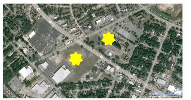
The corridor is anchored by brownfields sites: the northernmost end is the former Shipwatch Square Shopping Center and the southern end is the former Chicora Tank Farm, a former Navy bulk fuel storage facility. Both of these sites, shown on Figure 1, were assessed in 2010 by the City of North Charleston’s EPA Brownfield Assessment Grants.
The Shipwatch Square Shopping Center once housed Glamour Cleaners, a dry-cleaning facility that released chlorinated solvents to both site soil and groundwater at the site. After the City of North Charleston purchased the site, partial funding from the South Carolina Dry Cleaning Facility Restoration Trust Fund remediated contaminated soil at the site. Since its assessment and clean-up, a portion of the Shipwatch Square Shopping Center has been redeveloped with Restaurant Depot, a restaurant wholesale business. The remaining portions of the site have been purchased by a developer and remains undeveloped.
The Chicora Tank Farm was previously developed with a bulk fuel storage facility for the Department of the Navy. The 23-acre site was constructed with six bulk storage tanks, two transformer buildings, and a warehouse. Fuels and waste oils were transferred via underground piping between the tanks and the nearby Naval Shipyard. The US Navy conducted several assessments, soil clean-ups, and groundwater extraction due to contaminated groundwater.
The City of North Charleston purchased the site and has developed a new fire station, basketball courts, and sports fields for the adjacent Military Magnet school.
A third brownfield site in the corridor was assessed as part of the prior EPA Brownfield Assessment Grants: 1901 Reynolds Avenue. The site is developed with four unregistered underground storage tanks (USTs). A Phase II ESA conducted in 2012 did not identify any impacts from the former operation of the USTs. Minor surface soil contamination by polynuclear aromatic hydrocarbons (PAHs) was identified. Prior to redevelopment of the site, the four USTs must be property abandoned in accordance with South Carolina Department of Health and Environmental Control (SCDHEC) UST Regulations. Additionally, SCDHEC recommended that any future purchaser of the site enter into a Non-Responsible Voluntary Cleanup Contract (VCC) with SCDHEC. The VCC Program allows purchasers of contaminated property to not be held responsible for previously caused contamination.
No other assessments were conducted on properties within the corridor during the prior EPA Assessment Grant; however, an inventory of potential brownfields site was prepared. As detailed below, this prior inventory has been expanded and updated as part of the AWP Grant process.
Expanding on previous brownfields work in the Corridor, a parcel-scale inventory of known and potential brownfield sites was conducted within the Corridor. The brownfields inventory utilized various sources of regulatory and historic data sources, as well as a windshield survey of the entire corridor. One source is an environmental regulatory database search completed by Environmental Data Sources, Inc. (EDR) and summarized in its April 26, 2019 report. The EDR report provides a listing of facilities that are identified in a range of state, federal, and other environmental databases. Such facilities include listings of dry cleaners, registered USTs, handling and/or generation of hazardous waste, known brownfield sites, and others. A listing in one or more databases does not necessarily make a facility a brownfield site, nor does it confirm that a release has occurred, but merely provides an indication that certain chemicals of concern were stored, used, or generated at a facility.
• Historic Sanborn Fire Insurance Maps – these maps were periodically published by the Sanborn Map Company to allow fire insurance companies to assess their total liability in urbanized areas. The maps routinely depict the use and storage of chemicals of concern and operations that include use of potential hazardous materials.
• City Directories – City Directories list address-byaddress occupants for various streets. City Directories dating back to the 1950s were reviewed to identify facilities that may have handled petroleum products and/or hazardous materials.
• Aerial photographs – historic aerial photographs of the Corridor were reviewed to evaluate the potential presence of brownfields. However, most of the parcels in the Corridor are fairly small and due to lowphotograph resolution, it is difficult to identify potential brownfields using the aerial photographs.
Lastly, a windshield survey of the Corridor was conducted in May 2019. Using the historic and historic records data, potential brownfields sites were observed to document current conditions. Additionally, indications of vacant, blighted, and underused properties were noted, especially those with potential.

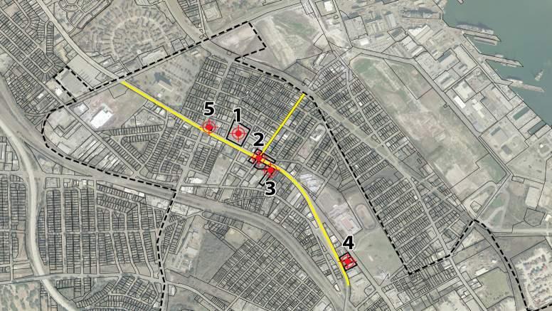
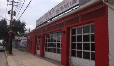
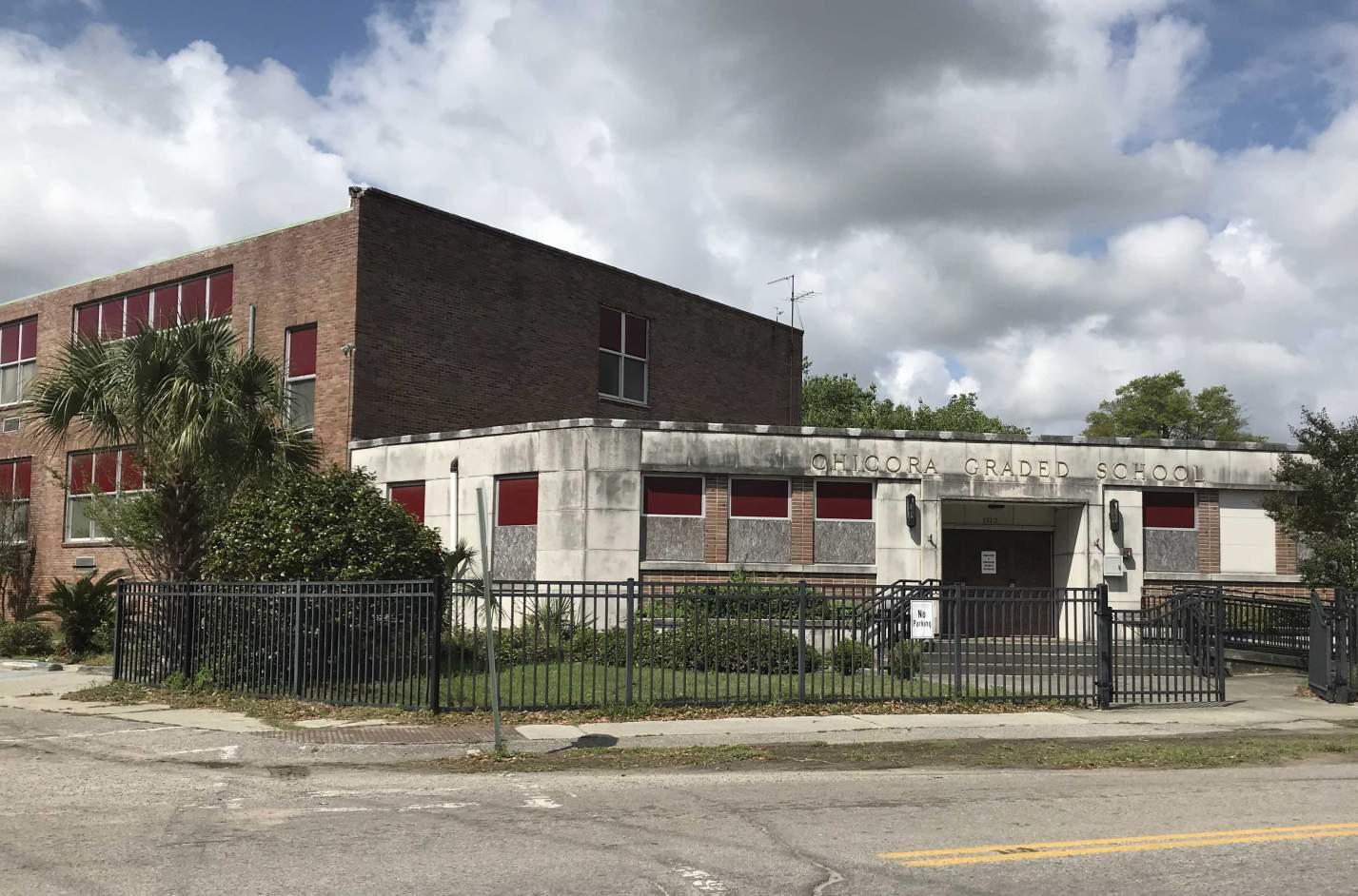
Focus Site 1: Former Dryclean USA Coastal, Inc. Facility - located at 3346 Rivers Avenue focus site 1 is one of the largest brownfields on the corridor and has high visibility on Rivers Avenue.
Focus Site 2: All four corners of Rivers Avenue and Reynolds Avenue - located at 3255, 3303 and 3308 Rivers Avenue and 2025 Reynolds Avenue with 3255 serving currently as an active gas station and the other three corners having historically been gas stations.
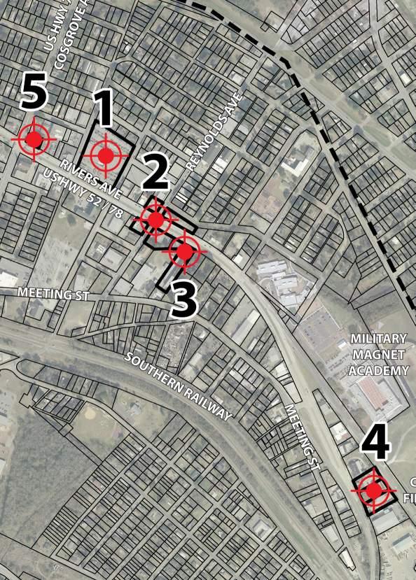
Focus Site 3: Star of America Hotel - located at 3245 Rivers Avenue this site has been a number of brownfield type uses including an auto sales facility, auto repair garage, a dwelling and a meth lab.
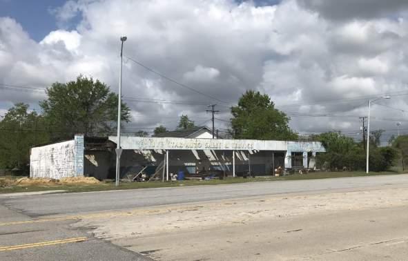
Focus Site 4: Former Body Shop and Salvage Yard - located at 2867, 2873 and 2900 Rivers Avenue has always been either a salvage yard or a storage yard.
Focus Site 5: Former Gulf Oil Service Station - located at 3376 Rivers Avenue - currently a CARTA super stop but with the coming BRT, this will move elsewhere and therefore be up for possible redevelopment.
Aside from the focus sites, 39 other potential brownfield sites were identified in the brownfield inventory process (Figure 1.1). Most of the sites are former gas stations, auto repair facilities, dry cleaners and machine shops, most of which have not been assessed. The first step for each facility is to conduct a Phase I ESA, complete with a review of historic and regulatory data to identify areas of potential impacts.
THIS PAGE WAS INTENTIONALLY LEFT BLANK
4.1 INTRODUCTION
4.2 ADVISORY COMMITTEE
4.3 TWO-DAY STAKEHOLDER MEETING
4.4 PUBLIC OPEN HOUSE
4.5 COMMUNITY DESIGN CHARRETTE
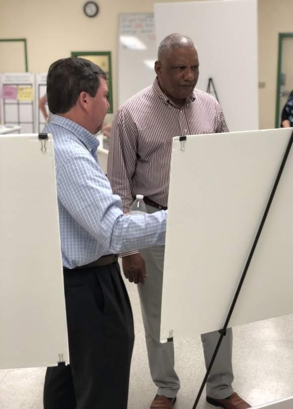
While public engagement is a required part of the Brownfield Area Wide Planning (BFAWP) Grant, it also plays an integral part in our design team’s planning process. As part of our community outreach process, the Berkeley Dorchester Charleston Council of Governments (BCDCOG) formed a Brownfield Planning and Advisory Committee (BAC) – that includes community stakeholders within the identified EPA approved study area. This advisory committee is the primary forum for reviewing alternatives and making community-driven decisions based on community outreach efforts and the team’s planning recommendations. With this combination of community participation and stakeholder direction, our planning effort not only leads to a design that better suits the community but can be vital to implementation. The momentum created during this publicly driven design process gives the project the political will necessary for implementation.
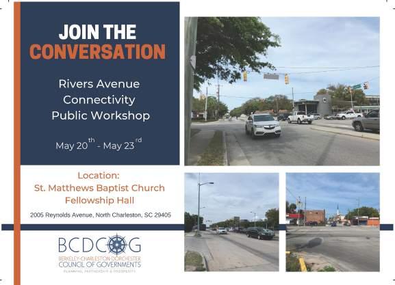
The first community outreach event was a two-day stakeholder event on April 24th and 25th, 2019. The second was a week-long design charrette from May 20th through May 23rd, 2019.
These events helped identify the community’s needs and desires as well as the potential focus sites. The community shared their vision for the area along with connectivity priorities for their neighborhoods.
As part of the grant process, the BCDCOG formed an Advisory Committee to be the community leaders that would direct the Brownfield Area Wide Planning Grant project team. The team met monthly throughout the project and identified potential brownfields and helped the team connect with the local community. The project manager worked with these local representatives to schedule public engagement and set specific deadlines for the project.
The advisory committee was established with representatives from the City of North Charleston, the City of Charleston, Charleston County, SC Community Loan Fund, South Carolina State Ports Authority, Metanoia/Pushing Forward, The Sustainability Institute/Upper Peninsula Initiative, SC Department of Health and Environmental Control (SCDHEC), LAMC, and US EPA Region 4. These representatives and organizations provided oversight to the project as well as helped provide venues for sharing information, raised and discussed ideas, increased overall community participation, and identified other stakeholders and engagement opportunities.
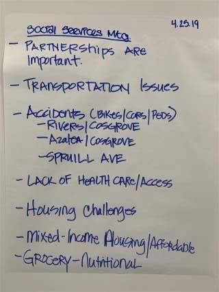
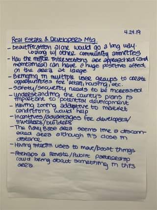
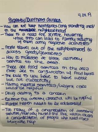
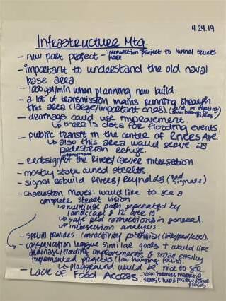
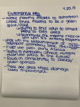
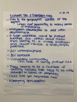
On April 24th and 25th, 2019, local stakeholders were invited to discuss the planning corridor. The group emphasized that the focus area for this project is the geographic center of the region. It is within close proximity to many vital areas; downtown Charleston, the Cooper River, the Ashley River, and various major and minor highways/roads. New projects impacting the area are a new port access roadway and Bus Rapid Transit system.
Stakeholder meeting discussions centered around the lack of connectivity and access within the area. The area was also characterized by participants as being:
• Central to the geographic region

• Within close proximity to many key areas (downtown Charleston, the Cooper River, the Ashley River, and various major and minor highways/roads)
• Near an upcoming port access roadway project
• Having mostly state-owned streets
• Extremely dangerous for pedestrians
Also from these talks it was discovered/noted that the area has the following constraints when it comes to physical accessibility and goods/services access:
• Lack of connectivity for residents to local rivers, parks, local food banks, schools, and necessary/similar services
• Extremely unsafe pedestrian crossings due to wide roads and intrusive railroad tracks
• Lack of educational and employment opportunities and resources, mental health resources, healthcare/urgent care, groceries, and varied food options
Area Threats according to the Pros
Housing Pressure
Rising Costs
Future Opportunities according to the Pros
Affordable Multi-Story Housing
Single & Multifamily Infill Housing


Food/ Grocery


Access
Office Space
Retail Space
Flip chart notes from the Stakeholder Meetings
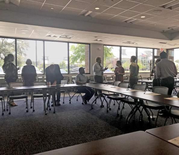
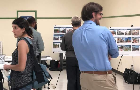
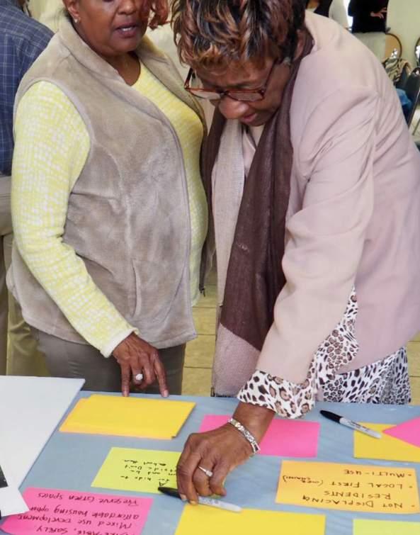
On the evening of April 25th, the Gussie Greene Community Center was the setting for a Public Open House that began at 6PM. The community, relevant local City/ County figures, local business owners, and neighborhood residents participated in the event.
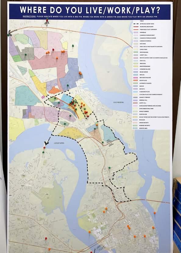
Numerous stations were set up around the room to engage the public and solicit specific feedback on various topics. Visitors were welcomed and encouraged to participate in each activity.
Participants were given three colored push pins: red, green and orange. The red push pin represented where they live, the green push pin represented where they work and the orange push pin represented where they play (socialize, “hang out”, etc.).
The intention of this station was to give people an understanding of what a brownfield actually is. Not only did we define it but also showed visuals of the different types of lots/properties that would be considered a brownfield.
EPA definition: “Brownfields are real property, the expansion, redevelopment, or reuse of which may be complicated by the presence or potential presence of a hazardous substance, pollutant, or contaminant.”

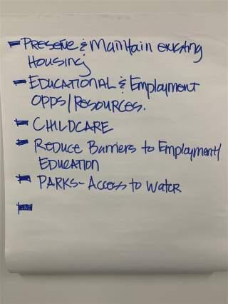
Station Three: Preferred Investment Bucket Activity
At this station, participants were to use black poker chips, that signified public dollars, in order to choose what they feel needs the most investment.
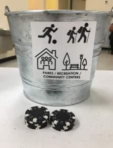
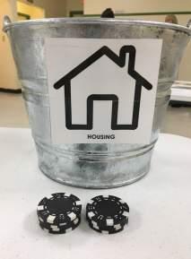
Community big winners:
The five categories were:
• Parks/Recreation/Community Centers
• Bicycle Facilities

• Pedestrian Facilities
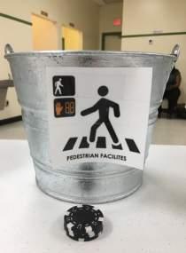
• Community Services
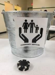
Housing Parks, Recreation, and Community Centers
Bike Lanes and Facilities
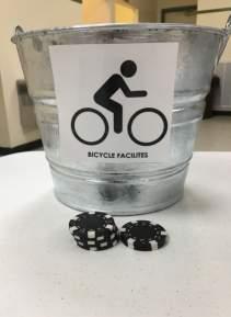
9 Chips
9 Chips
7 Chips
4 Chips
4 Chips
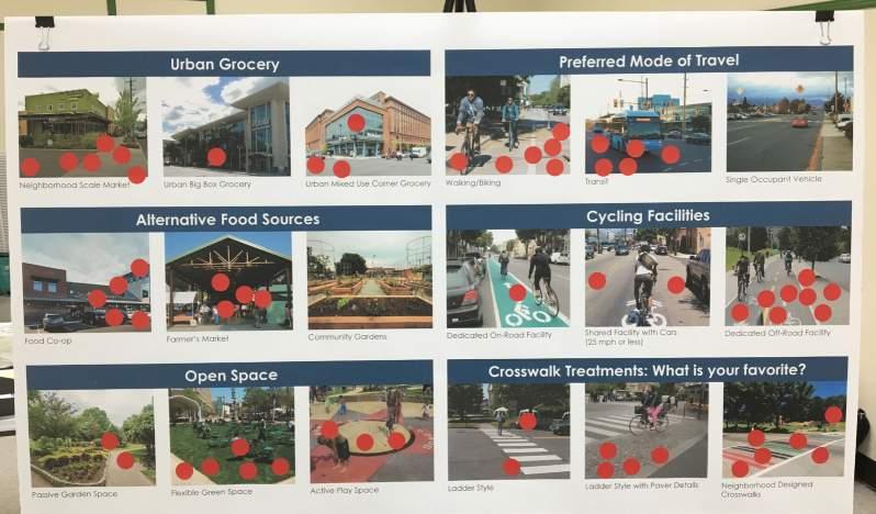
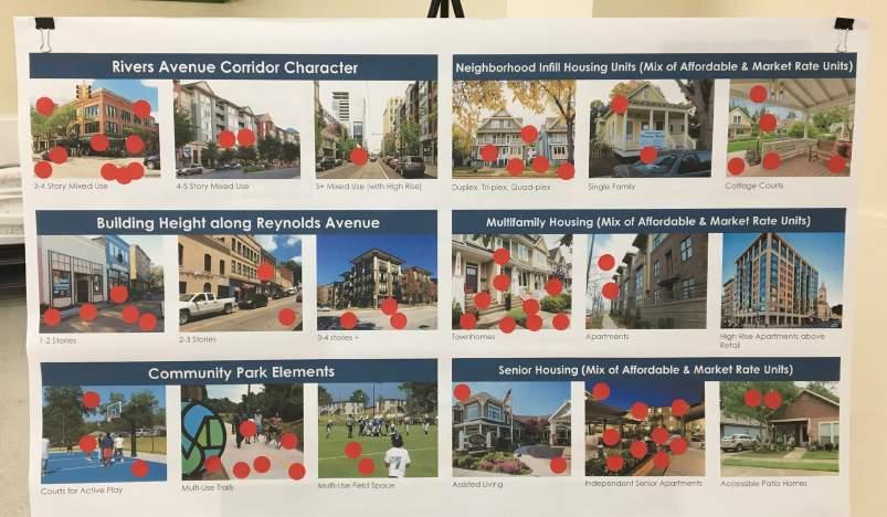
The Visual Preference Surveys offer a variety of visual options related to various community elements. Participants were given red dot stickers to place on the image they prefer most in each category. This information helps the design team understand the aesthetic and design preference of the community.

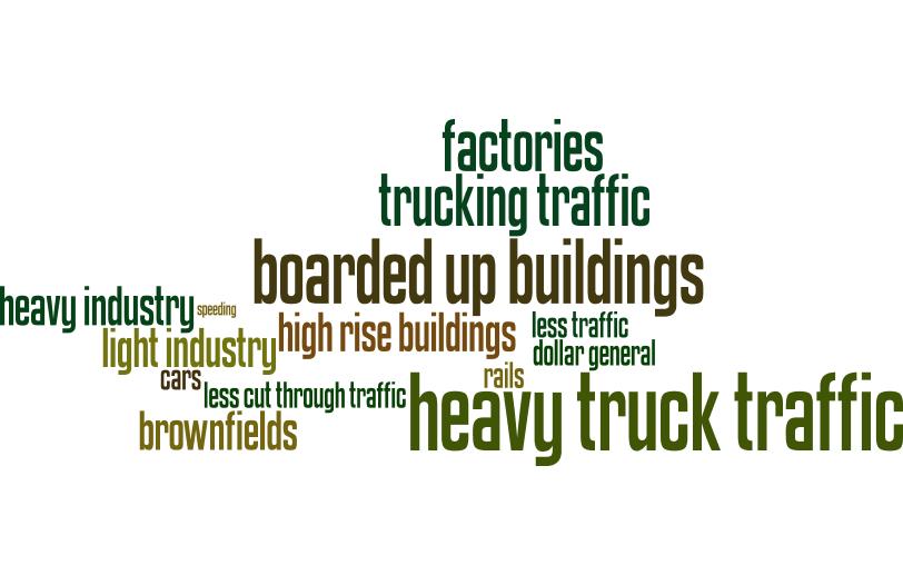
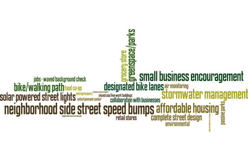
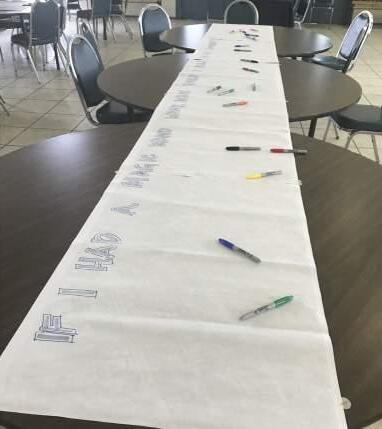
Graffiti boards were set up in order to figure out what the public felt the area could use both “More” and “Less” of. Participants were encouraged to write as many ideas as they could think of could think of for both categories.
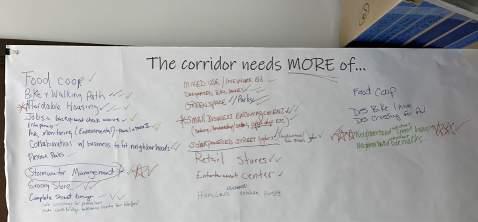
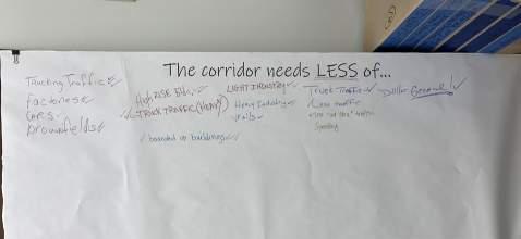
Wordles were created from the public comments at this station. A wordle is simply a graphic where repeated answers appear larger than others.
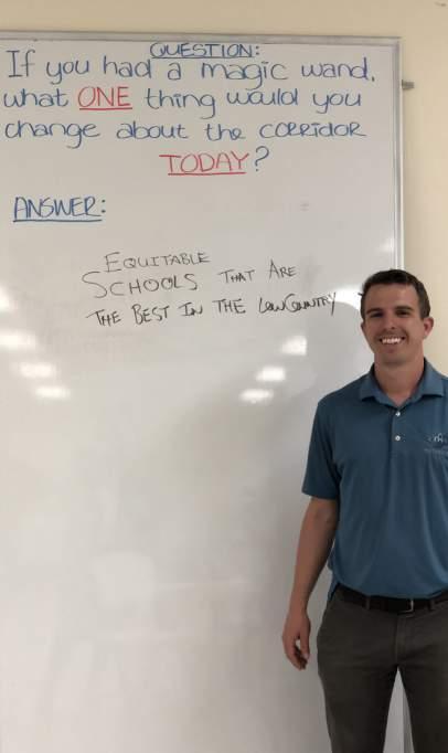
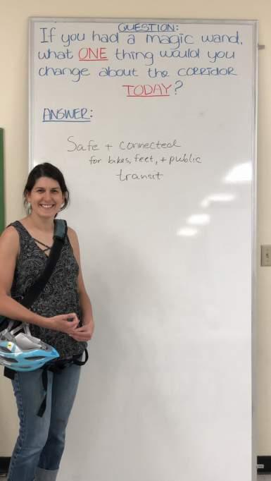
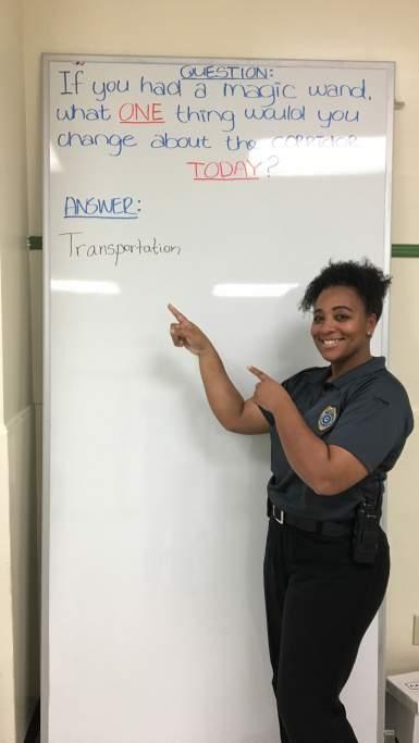
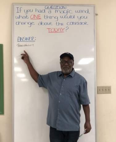
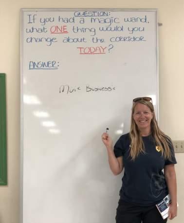
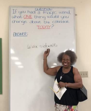
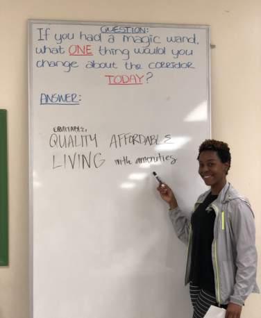
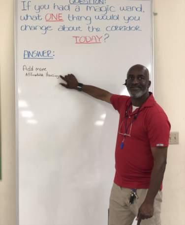
The Photo Booth was set up to inspire participants to think outside of the box. They were asked to imagine if they had a magic wand and could change one thing about their community. The design team used these lofty goals to inspire the vision of the area and create recommendations to make these dreams a reality.

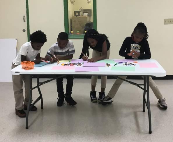
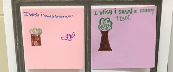
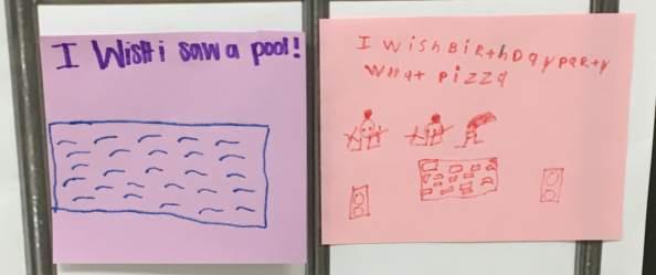
This station engaged the children of the community to express what they would like to see in their neighborhood. Boards with faux windows were placed in the station along with construction paper and colored markers. The drawing prompt for the children was to imagine looking out of their window at home or at school and drawing what they wish they saw. The ideas were imaginative and filled with hope for a brighter future.


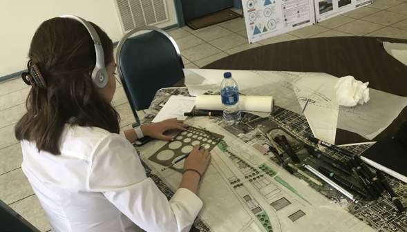
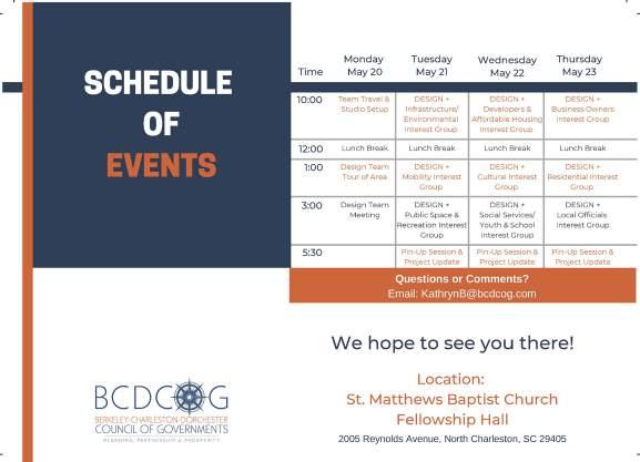
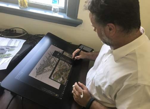
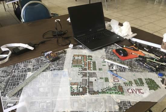
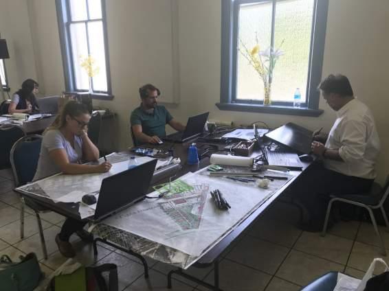
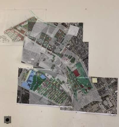
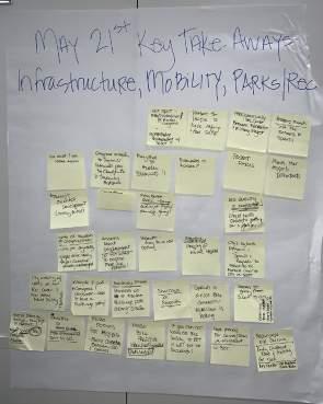
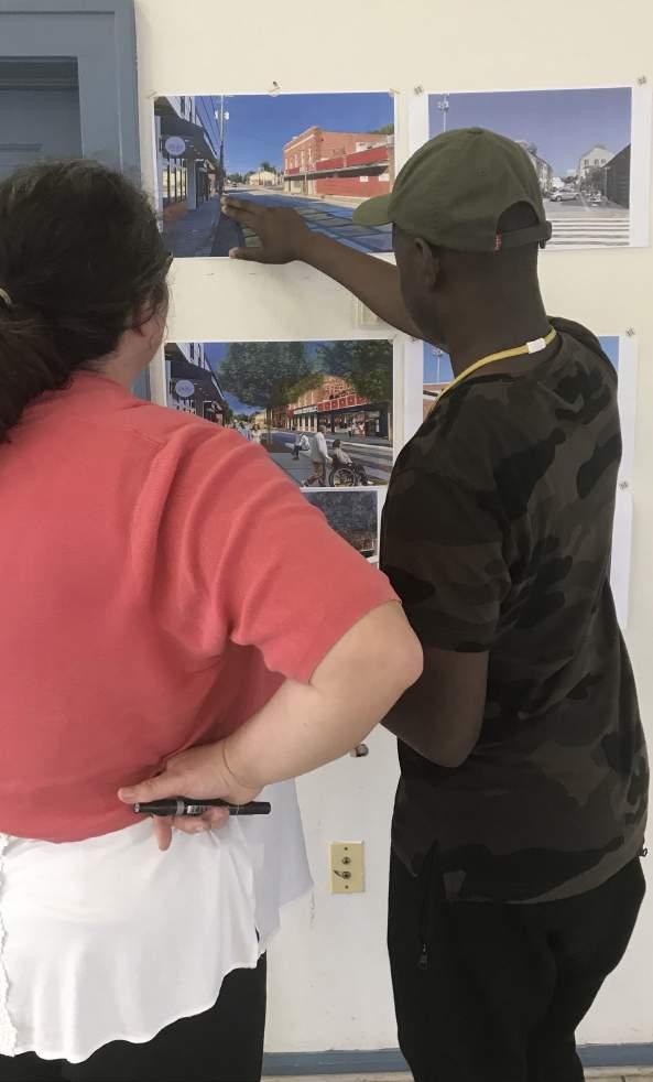
The design team prepared for the week-long design charrette (May 20th through 23rd, 2019) by completing research, market analysis, and a driving tour of the area. The team spent the week working at St. Matthew Baptist Church on Reynolds Avenue at the heart of the planning corridor. During the week, stakeholders across multiple disciplines came in to discuss current projects and conditions within the planning corridor as well as their visions for the future. Each day, progress was presented in a design pin-up. Attendees were encouraged to comment on ideas and drawings.
Key public input from the week included the following comments:
• Lack of pedestrian connectivity and safety
• Need for new housing typologies without gentrifying the neighborhoods
5.1 CURRENT DEVELOPMENT IMPACTS
5.2 GUIDING PRINCIPLES
5.3 DEVELOPMENT TYPOLOGIES
5.4 OVERALL PLAN & DATA
5.5 FOCUS AREAS
The Prime North Charleston Comprehensive Plan is currently underway and will shape additional land use and policy related to this planning effort. The City is also working toward a corridor overlay for Rivers Avenue that will encourage transit-oriented development and walkable neighborhoods. Requiring development to address the street and place parking in the rear is a major step toward creating a safe, vibrant pedestrian environment.
The Lowcountry Rapid Transit system providing future service (26 miles) between Summerville and Charleston will spur economic development along the corridor. This new regional amenity should carefully interact with the existing neighborhoods along Rivers Avenue ensuring high quality intersections, safe crossings and transit stops, and access to goods and services.
Metanoia is a Community Development Corporation embedded in the heart of the study area and serves as a non-profit advocate for sustainable change in North Charleston. The organization’s staff works hand-in-hand with the neighborhood residents to find solutions related to affordable housing issues and small business development. Metanoia offers programs that build community leadership, and their Biblical roots are held firmly in creating positive changes in the lives of people around them.
In the past decade, the City purchased and donated property to the County School District for the construction of the new Chicora Elementary School (CES) to ensure this center of learning stayed in the Chicora/Cherokee Neighborhood. In turn, the school district donated the historic CES building and property. Metanoia plans to reactivate the property with business incubator space, an early childhood education center, and art space. The former auditorium will become a performing arts center for the City to program and expand the cultural offerings available to neighborhood residents. This hub of community learning received a jolt from local company Ingevity with a $400,000 donation to the project in January 2019. The Mayor has called this project the basis of the next “bloom area” for the City.
Historic Chicora Elementary School is the future site of a community performing arts center, early childhood learning program, and artist loft spaces
A ULI Advisory Services Panel composed of creative professionals came to the study area for a five-day intensive workshop in March of 2019. Their time included getting to know the area, public interaction, and design.
The ULI Panel’s objective opinion is to tear down the Navy Hospital Building and prepare the 22-acre site for redevelopment. They site a sensitive approach to this redevelopment with care given to uses, design, zoning, transit orientation, public space, and affordability. The panel sees this site as a catalyst for new investment in southern North Charleston, and while prosperity is needed, this growth does risk displacement of people and businesses. Their recommendations include the City and County protecting current affordable housing and channeling resources through funding, programming, and partnerships to create new affordable housing opportunities in the area.
ULI’s vision for the Navy Hospital Site includes a mix of retail shops, a grocery store, a transit center, mixed-income housing units, and community spaces. The panel of experts strongly discourages auto-oriented uses such as gas stations and drive-thru businesses.
The City of North Charleston is a community that believes in sustainable development principles. In fact, they were recently given the Award of Excellence for Sustainable Community Development from The Home Depot Foundation. As a place that holds the virtues of ensuring a resilient future, the study area’s development should follow those same principles of Smart Growth employed elsewhere in the City.
Growth and progress are inevitable for this portion of Rivers Avenue due to public investment in regional transit. With progress comes a critical crossroads for the communities along the corridor. Capitalizing on those public and private investments in a way that produces value is key-not just monetary value, but social value as well.
Smart Growth principles enhance a community’s quality of life, the local economy, and the environment. As we think about the redevelopment of this corridor, we must strive to preserve the very best of its history while paving the way for a sustainable future. Residents must have choices when it comes to housing, mobility, schools, goods/services, and jobs.
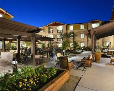
Mixed use environments create vibrant, people places
Key guiding principles of Smart Growth and their benefits are listed below:
1. Mix Land Uses
• Creates vibrant and diverse communities
• Provides great places to live, work, and play
2. Take Advantage of Compact Building Design
• Creates convenient neighborhood centers
• Uses land efficiently
• Reduces flooding and stormwater issues
• Achieves density needed to support viable transportation alternatives
• Delivers services efficiently
3. Create a Range of Housing Opportunities & Choices
• Uses infrastructure resources efficiently
• Accommodates aging in place
• Provides quality housing for people of all income levels
• Improves a community’s quality of life
• Ensures a better jobs-housing balance
• Generates support for walkable neighborhoods
4. Create Walkable Communities
• Provides appropriate mix of densities and uses
• Creates compact street intersections
• Scales neighborhoods to people
5. Foster Attractive Communities With A Strong Sense Of Place
• Represents the values of residents
• Reflects the unique historical, cultural, economic, and geographical context of the area
• Uses natural and man-made boundaries and landmarks to define neighborhoods
• Encourages the construction of high quality infill and preservation of historic buildings
6. Preserve Open Space, Natural Beauty, & Critical Environmental Areas
• Provides recreational opportunities
• Guides new growth into existing communities
• Improves quality of life
• Enhances the region’s economic prosperity
• Locates new development in cost-efficient places by respecting a community’s “green infrastructure”
Existing Communities
• Creates a stronger tax base
• Provides closer proximity of jobs and services
• Increases efficiency of developed land and infrastructure
• Reduces development pressure in fringe areas
• Preserves open space.
• Improves local and regional water quality
• Creates opportunities for mobility options,
• Improves regional air quality
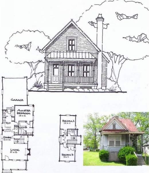
Existing neighborhoods, such as Accabee and Chicora/ Cherokee, can capture much of the growth that communities anticipate through infill development, brownfield redevelopment, and the rehabilitation of existing buildings. In the case of redeveloped brownfields, existing neighborhoods can benefit from public and private investment, more jobs, higher property values, and additional local tax revenue.
• Coordinates land use and transportation
• Increases the availability of high quality transit service
• Creates resiliency and connectivity within the network for pedestrians, cyclists, transit users, and drivers
9. Make Development Decisions Fair, Predictable, & Cost Effective
• Reduces barriers to profitable smart growth development practices
10. Encourage Community & Stakeholder Collaboration in Decision Making
• Ensures early and frequent involvement of all stakeholders
• Identifies and address specific needs and concerns
• Ensures a high level of public awareness
• Helps local leaders better identify and support development that meets identified needs
Summarizes Applicable Guidelines Created by “Getting to Smart Growth” www.smartgrowth.org
The concept plans in Sections 4.4 and 4.5 illustrate various development typologies related to housing, commercial, transit-oriented development, and flex employment space. To understand the visual character of what (in some cases) may be a new building form for this community, these ideas are illustrated below.
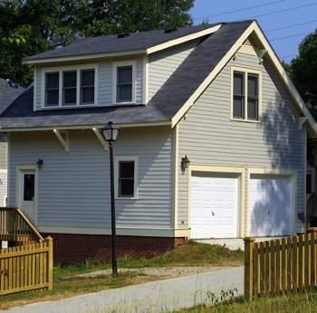
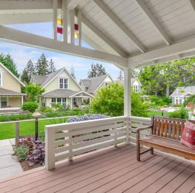
The existing housing types found within the study area include single family homes, duplex units, and apartments. The design intent is to introduce a variety of both affordable and market rate housing types into the existing neighborhoods. This infill strategy involves a careful examination of what homes are contributing historic structures layered with homes that are clearly being cared for and occupied. It should be noted that every home that should be saved isn’t necessarily considered “historic.” Also, in the case of an existing home on a deeper lot, the introduction of an accessory dwelling unit can provide an affordable housing option that creates density and additional income for homeowners.
Narrow Lot Single Family-Homes generally serviced by an alley block system and on-street parking; affordable and market rate units can be mixed in the same block because the frontage condition is consistent; however, the market rate units may extend deeper onto the lot for more square footage or the finishes can be slightly different between the two unit types
Duplex/Triplex-Two or three units housed in a single structure
Quad/4-Pack-Four units housed in what appears to be a larger single family home
Apartments-Multiple units housed within one building that share entry/ exit points
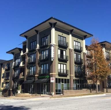
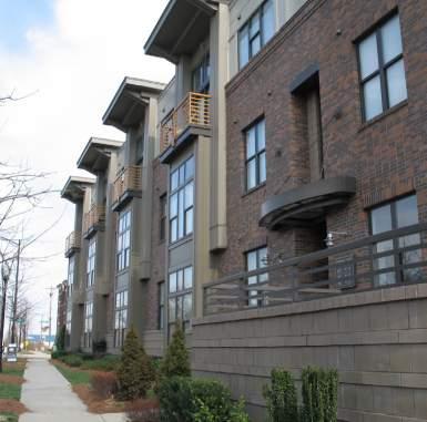
Lofts/Condos-Units housed above ground floor commercial space
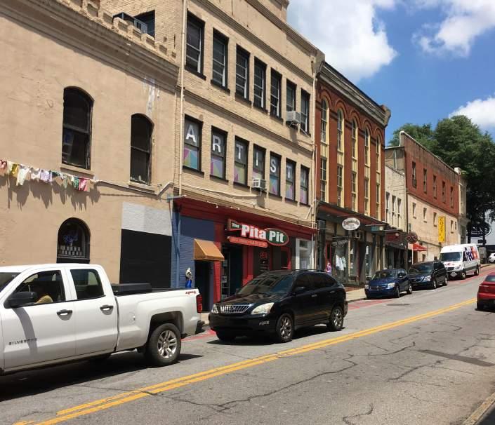
The commercial typologies indicated on the plans are in mixed-use scenarios. Mixing retail, office, and even housing contributes to the twenty-four hour nature of an area. This activity yields vibrancy which is the ultimate goal of all great places.
One key to success in commercial environments is requiring active ground floor uses such as restaurants and retail shops. The streetscape along with these active uses play together to create a successful public realm for pedestrians. The mix of uses above can vary between office and residential; the important aspect of the scenario is to create commercial environments with buildings that address the street, have wide sidewalks, on-street parking when possible, and parking hidden in the rear.
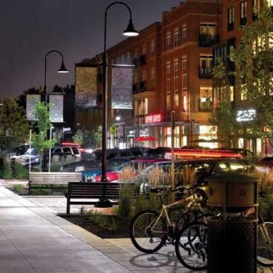
Mixed Use A: Active ground floor retail with office on second floor and residential on third floor
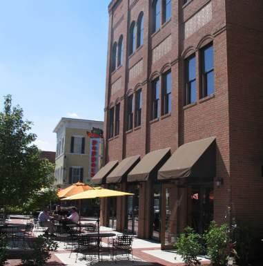
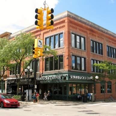
Mixed Use B: Active ground floor restaurant with two levels of office above
Mixed Use C: Active ground floor retail with lofts/condos above
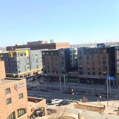
The Lowcountry Rapid Transit system creates an opportunity for higher density development at key stop locations; this is often referred to as transit-oriented development. The intention is to increase the number of jobs/services at a location that people are arriving at via the transit system while also increasing the number of housing units in a particular area to provide those residents with quick access to transit for their daily trip needs.
The area around the intersection of McMillan and Rivers Avenue has been identified as a major stop along the route with a multi-modal station planned.
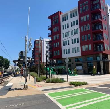
As smart mobility of the future edges closer to our reality, the development of the site should be flexible and reflect a society that is becoming less dependent on individual car ownership.
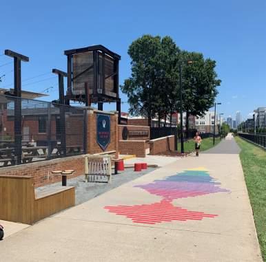
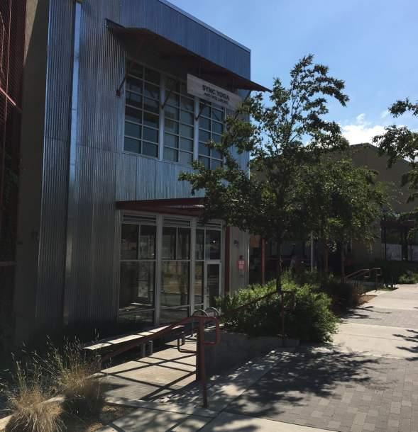
Affordable and flexible warehouse style space is growing in popularity due to business sectors like craft breweries and other “makers” looking for space to create their products for distribution. Simple building construction techniques are often employed; however, with appropriate development regulations in place, the streets, parking areas, and spaces between buildings can add beauty to the community.
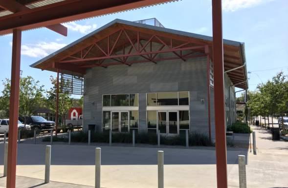
The overall concept plan focuses development around various brownfield opportunities and envisions those sites as catalysts for change. With the future bus rapid transit system routing through the heart of this study area, ensuring future connectivity across Rivers Avenue for neighborhood residents will be a key priority for any redevelopment.
The one-mile corridor is home to unique contexts from north to south including empty brownfield sites, an abandoned Naval Hospital on 22 acres, suburban big boxes, a neglected “Main Street” neighborhood center, civic campuses, flex/employment space areas, and of course, neighborhoods with varying levels of stability.
The plan examines the addition of mixed use buildings along Rivers Avenue while sensitively tying back into the existing neighborhood fabric. Parking is hidden behind buildings and heavily landscaped to include low impact stormwater opportunities along with shade trees.
Neighborhoods were examined for areas where sensitive, scale-appropriate infill could be inserted to add both quality affordable units along with market rate units. The civic elements of the corridor are co-located and accessible to residents and visitors. The expansion of the flex/employment space areas to the south adds more opportunities for workforce development.
The focus areas are detailed in Section 4.5, and the overall development data is summarized below:
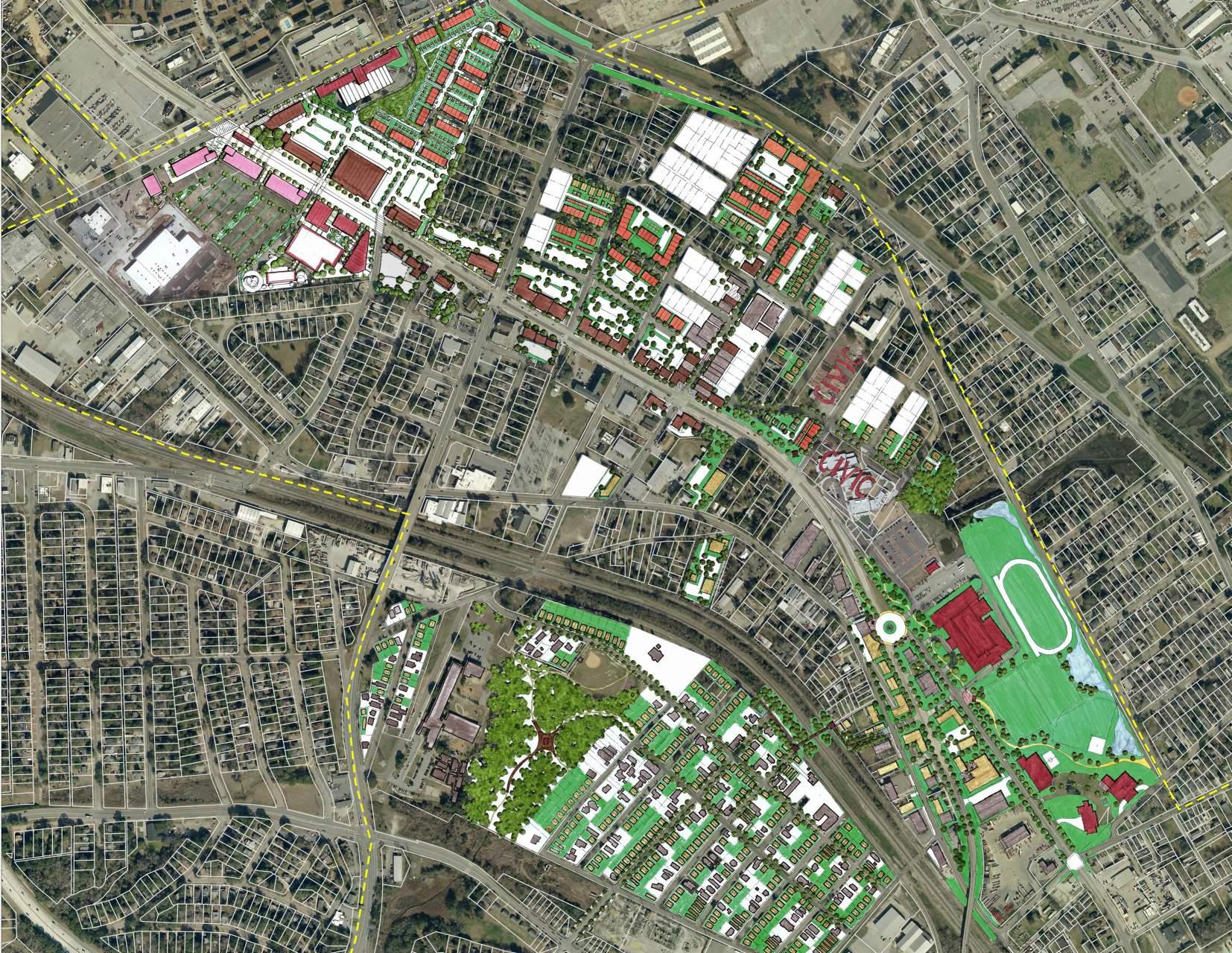
The properties at the intersection of McMillan Avenue and Rivers Avenue may be the properties most studied in the Charleston region. A plethora of plans and concepts exist for the former Naval Hospital site along with the adjacent property known as Shipwatch Square.
The Shipwatch Square site is a brownfield site that remains mostly undeveloped, yet is cleared of former buildings and has been remediated. Restaurant Depot, a commercial wholesale food distribution hub, was recently constructed along the Meeting Street Road edge. The former Naval Hospital Site is a 22-acre site with a ten story building and large surface parking area.
With the anticipated multi-modal center on the Naval Hospital Site, the remainder of the site is envisioned as a transit-oriented development (TOD) with a mixture of uses. Ground floor retail and restaurants line the frontage
of Rivers and the intersection at McMillan, while a new neighborhoodscale grocery store provides much needed access to fresh food for residents. Surface parking is situated in the rear of the buildings with heavily planted landscaping. The intersection building design preserves several majestic live oaks which contribute to the character of the area. The multimodal center lines the frontage of McMillan with bus circulation in the rear and a constructed wetland provides a buffer between the transit area and the neighborhood.
Neighborhood streets including Cosgrove, Cochise, Osceola, Apache, and Navajo are extended into the development to enhance local connectivity. The existing single family cottages in this area transition to new mixed income townhomes on the hospital site served with alley-loading garages, tree lined streets, and common open space.
The Shipwatch Square site is envisioned as an office/employment
center with buildings fronting along McMillan and Rivers. Limited retail/ restaurant space should be provided at the intersection to support the daytime office population. The parking field is located at the back of the buildings with rain gardens and shade trees for stormwater absorption.
The County Library Branch is housed on the adjacent property, and the County is currently re-envisioning the area as a larger civic/cultural node. The plan indicates a mid-block pedestrian crossing between the new cultural facilities and office development on the south side of Rivers with the TOD on the north side of Rivers. A pedestriancontrolled signal and high visibility crosswalk with median refuge should be provided. This combination of civic, office, restaurant, retail, transit, and housing at the intersection of Rivers and McMillan will create a high level of vibrancy and a true gateway into the southern neighborhoods of North Charleston.
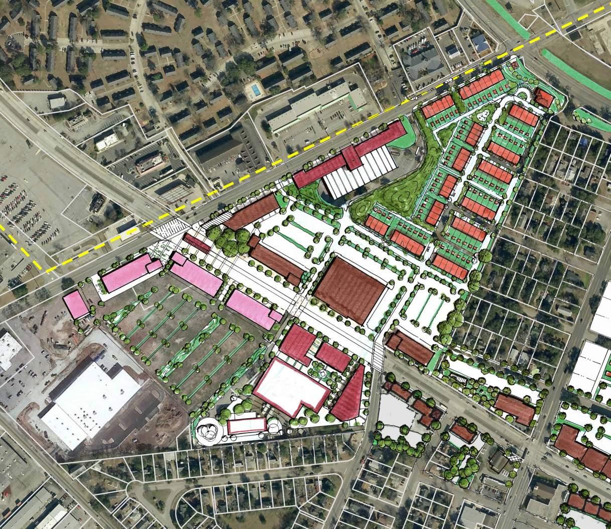
Birdseye rendering of proposed concept plan at McMillan & Rivers Avenue
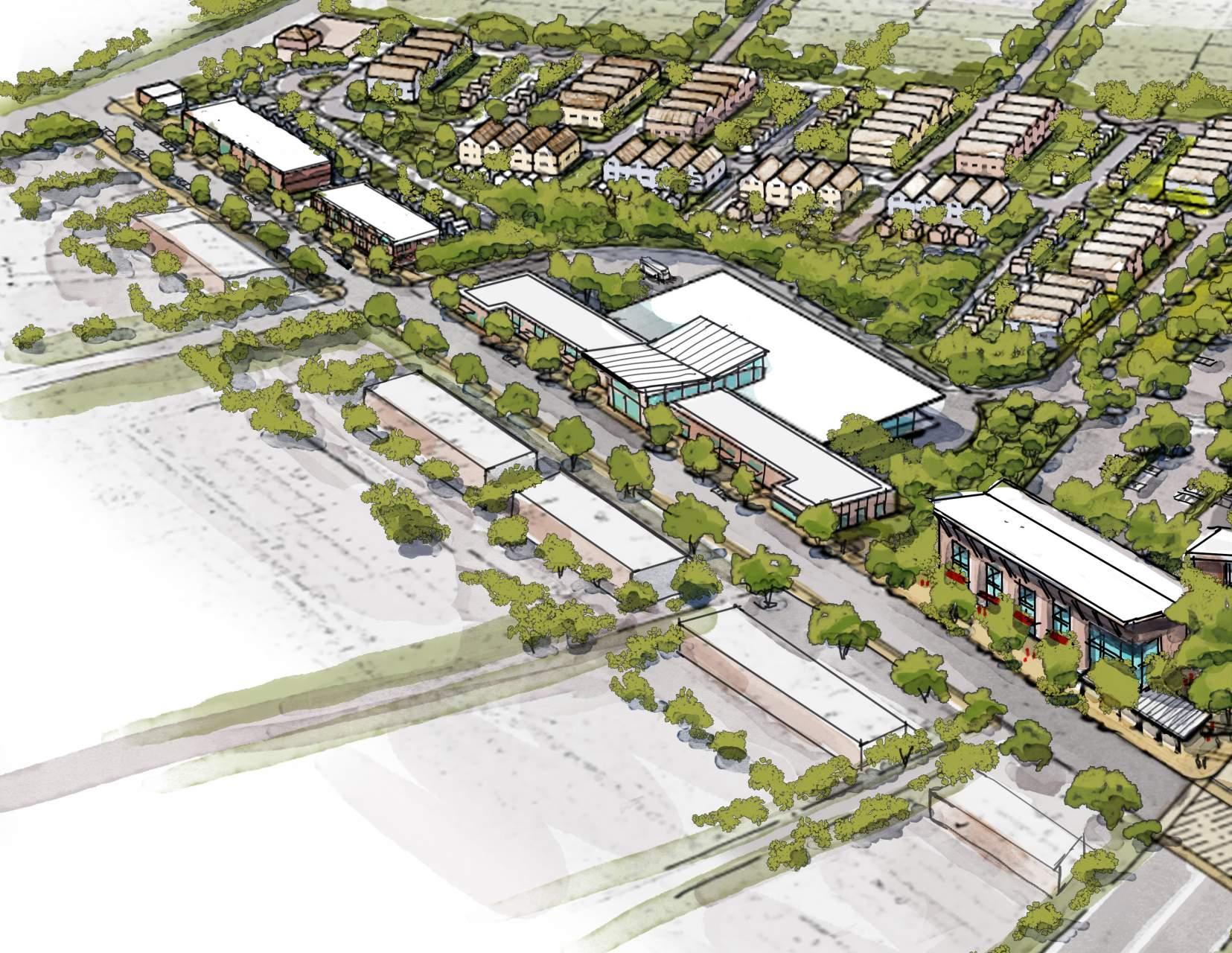 McMillanAvenue
Transit Center
McMillanAvenue
Transit Center
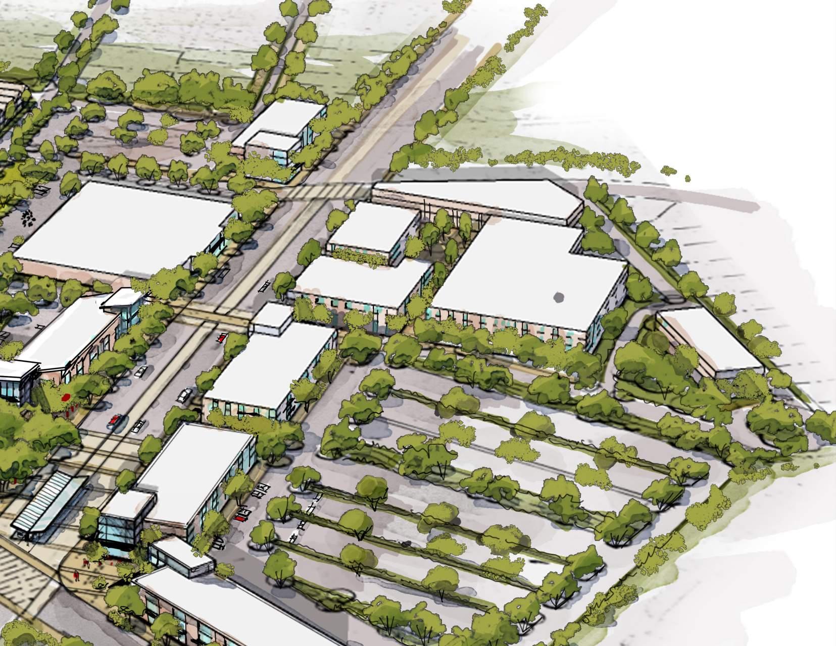

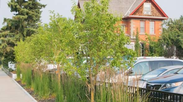
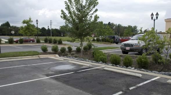
» Develop this area with a holistic vision and not on a parcel-by-parcel basis to ensure broad connectivity, walkability, and vibrancy.
» Update development regulations to require building frontage along Rivers Avenue with wide urban sidewalks and street trees. Require parking in the rear with shade trees and low impact stormwater best management practices.
» Leverage the rapid transit to attract a grocery/neighborhood market tenant.
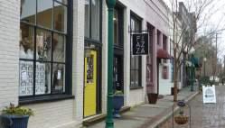
» Create high quality intersections that ensure safety for pedestrians, cyclists, transit users, and drivers.
» Ensure greater community connectivity in new development by extending existing streets whenever possible.
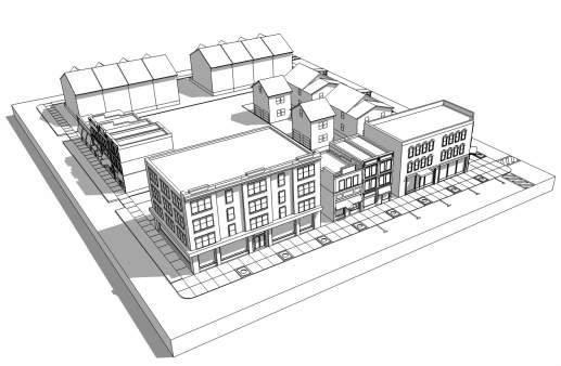
» Provide incentives for a percentage of new housing in the area to be below market rate to ensure the creation of a mixed income community.
» Provide great public spaces along Rivers Avenue utilizing unique character elements such as the live oaks found on the Naval Hospital frontage.
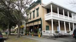
The properties at the intersection of Cosgrove Avenue and Rivers Avenue present varying opportunities for brownfield redevelopments, suburban retrofits, an active reuse of an existing building, and the preservation of a community church.
The Cosgrove intersection is a highly active area as the home of CARTA’s North Charleston Superstop on the northeast corner. The North Charleston Police Department South Bureau Substation is located at the southwest corner, and Cherokee United Methodist Church is found at the southeast corner. South State Bank on the northwest corner is a suburban style building that empties cars onto Rivers very close to the intersection. The bank is currently operating as an ATM only facility. Charleston County Social Services is also found along this portion of the corridor in aging big box structures with fields of parking along the street frontage. Aging multi-family units transition the blocks back into the neighborhood on Navajo and Apache Streets.
Understanding the new transit hub will be associated with the properties at McMillan and Rivers, the Cosgrove Superstop will no longer be at the intersection. The site it currently sits on is a brownfield as is the site where the police substation sits. The redevelopment of the Superstop is shown
in conjunction with the demolition of the social services big box. New mixed use buildings front Rivers with parking filling the remainder of the block to Navajo and extending for another half block. The two to three story buildings should have a mix that responds to the market at the time of redevelopment. Office is a better ground floor tenant in this location and keeps retail opportunities consolidated at the McMillan intersection and along Reynolds Avenue.
The aging multifamily beyond this new parking on Apache Street is re-envisioned as townhomes with a mix of unit prices. Osceola Street begins to transition to narrow lot single family homes some of which are existing and some infill to knit the success of that block back together.
The police substation’s current location does not work well for the officers from a circulation standpoint, and their services could occupy a future building on Reynolds Avenue. (See Section 4.5.3) The current building and site could be “actively” reused as a neighborhood restaurant as shown on the right. The outdoor space with its mature shade trees is an ideal public space easily enhanced with pavers/gravel, string lights, and new connections from the building. The remainder of this block is shown with a small mixed use building along Rivers Avenue.
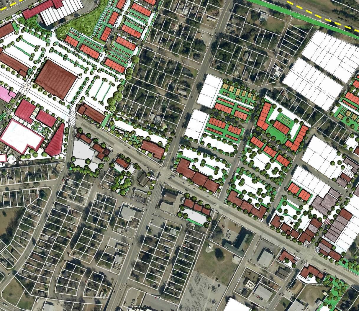
Single Family Infill Block
Townhomes Neighborhood Gardens
Linear Park & Local Transit Stop
Active Reuse with Public Space
Mixed Use (typical-ground floor office; upper floors residential)
The South State Bank site is conceptually illustrated with a new mixed use building along the Rivers frontage and parking in the rear. Additional frontage space that is too narrow for redevelopment due to parking depth needed is illustrated as a linear park and local transit stop. A few noteworthy live oaks are located in this potential park space and should be preserved.
The southeastern block is bookended by two churches, and the area between those buildings is illustrated as a small mixed use development. The consolidation of these properties also allows Lenape Street to punch through and connect to Cherokee across Rivers Avenue. This area is a prime candidate for creating shared parking agreements between the private businesses and the church—a strategy that reduces development costs and overall impervious impacts.
The properties that continue north along Cosgrove Avenue toward Spruill Avenue are not currently illustrated due to the uncertainty of a future bridge related to a truck route. The larger lots that front Cosgrove are largely occupied by derelict homes and buildings today. The existing lot sizes should be kept in tact with alleys added for access control. The infill building scale should be that of a medium-sized home even if the use is commercial to keep the area’s context appropriate for the neighborhood.
» Update development regulations to require building frontage along Rivers Avenue with wide urban sidewalks and street trees. Require parking in the rear with shade trees and low impact stormwater best management practices.
» Incrementally stabilize the neighborhoods through preservation and infill of mixed income housing typologies.
» Adaptively reuse buildings when possible by attracting active uses.
» Encourage the creation of quality public spaces in a variety of sizes along portions of Rivers Avenue too narrow for development.
Existing Conditions: North Charleston Police South Bureau Substation at Cosgrove and Rivers Avenues
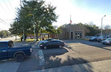
Proposed Concept: Adaptive reuse and activation of building and open space to create vibrancy along Rivers Avenue
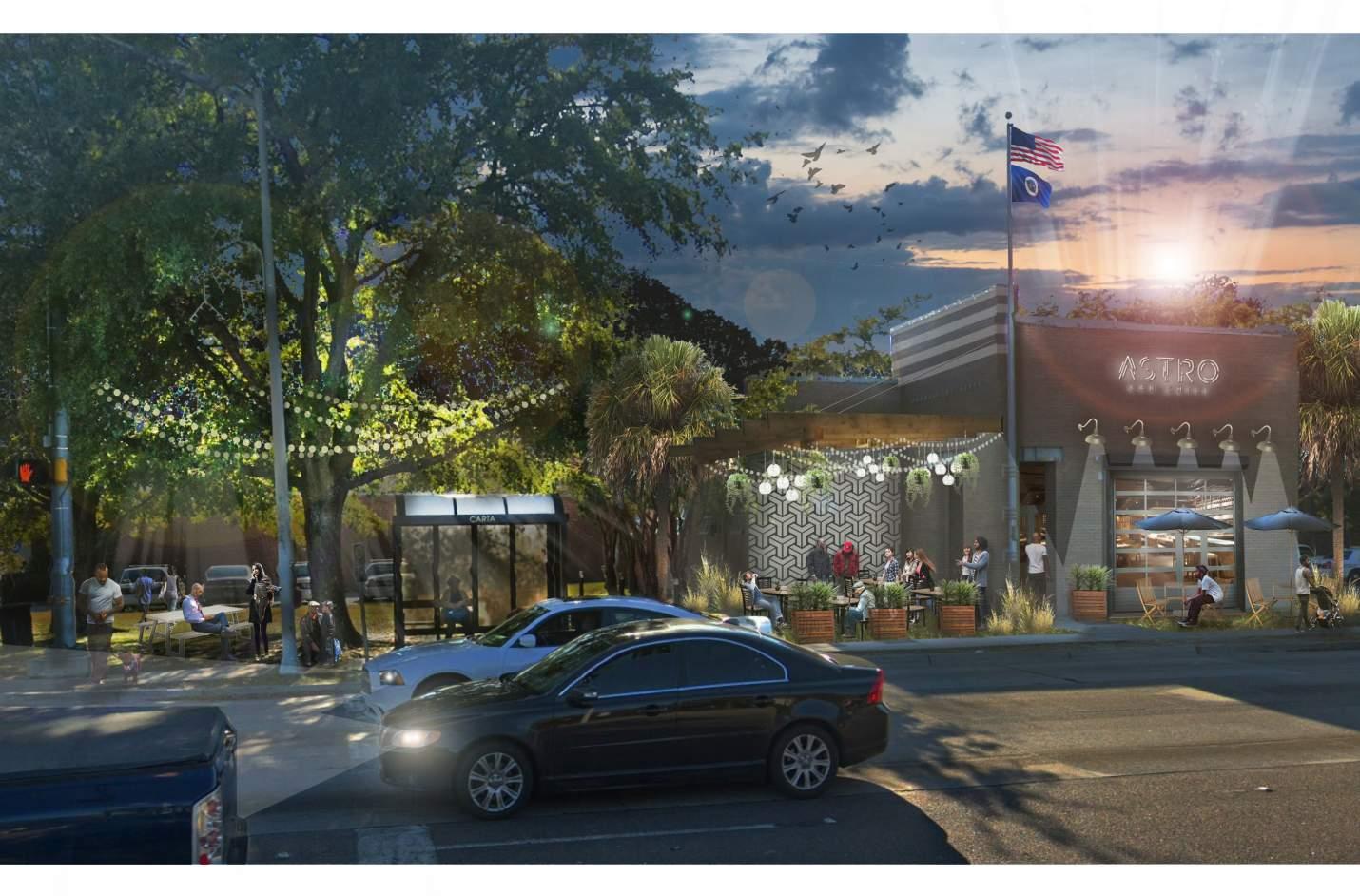
Reynolds Avenue is positioned to become an authentic “Main Street” within the Chicora/Cherokee area. The renaissance of this mixed-use neighborhood center has the ability to not only catalyze new development but to also restore pride to its residents.
Reynolds Avenue is characterized by empty, derelict buildings and brownfield sites. However, several churches call Reynolds Avenue home, and Metanoia has recently worked with local entrepreneurs such as Quan’s on King, a food truck vendor that has moved into their first brick and mortar space, and a new bakery that will open in early 2020. Other entrepreneurs are starting to take note of the energy on Reynolds and investing in other buildings along the avenue. The existing streetscape includes narrow sidewalks, unmarked parallel parking, and no street trees. Surrounding neighborhoods are fragile, but pockets of stability do exist.
The overall design strategy for this area strives to build on the positives and fill in the gaps where opportunities exist. The intersection of Reynolds and Rivers should be a true gateway to this “Main Street” environment. The four corners are brownfield sites and share a coordinated vision
of outdoor plaza space at each corner complemented by a high quality intersection with unique paving treatments and the best safety mechanisms available for pedestrians and cyclists. Additional mixed use buildings line Rivers Avenue heading northwest from the intersection and the parking is in the rear along with the existing cell phone tower. Moving southeast from the intersection, narrow brownfield sites along the corridor are once again converted into usable public space that provide safe pedestrian connectivity. These spaces take advantage of existing tree canopies and are enhanced with walking paths and other amenities. Troy Street is narrowed to a true alley with public parking in the rear of the buildings to accommodate the addition of a new building and to give the adjacent neighborhood blocks along Grayson and Troy more privacy. The intersection of Reynolds and Rexton is treated as a mid-
Housing 250 units
Mixed Use 114,600 sf
Office/Flex 27,900 sf
(Development data includes section 5.5.2)
Apartments
Neighborhood
Market & Garden
Cottage Court
Townhomes
Mixed Income
Infill Housing
Adaptive Community Reuse
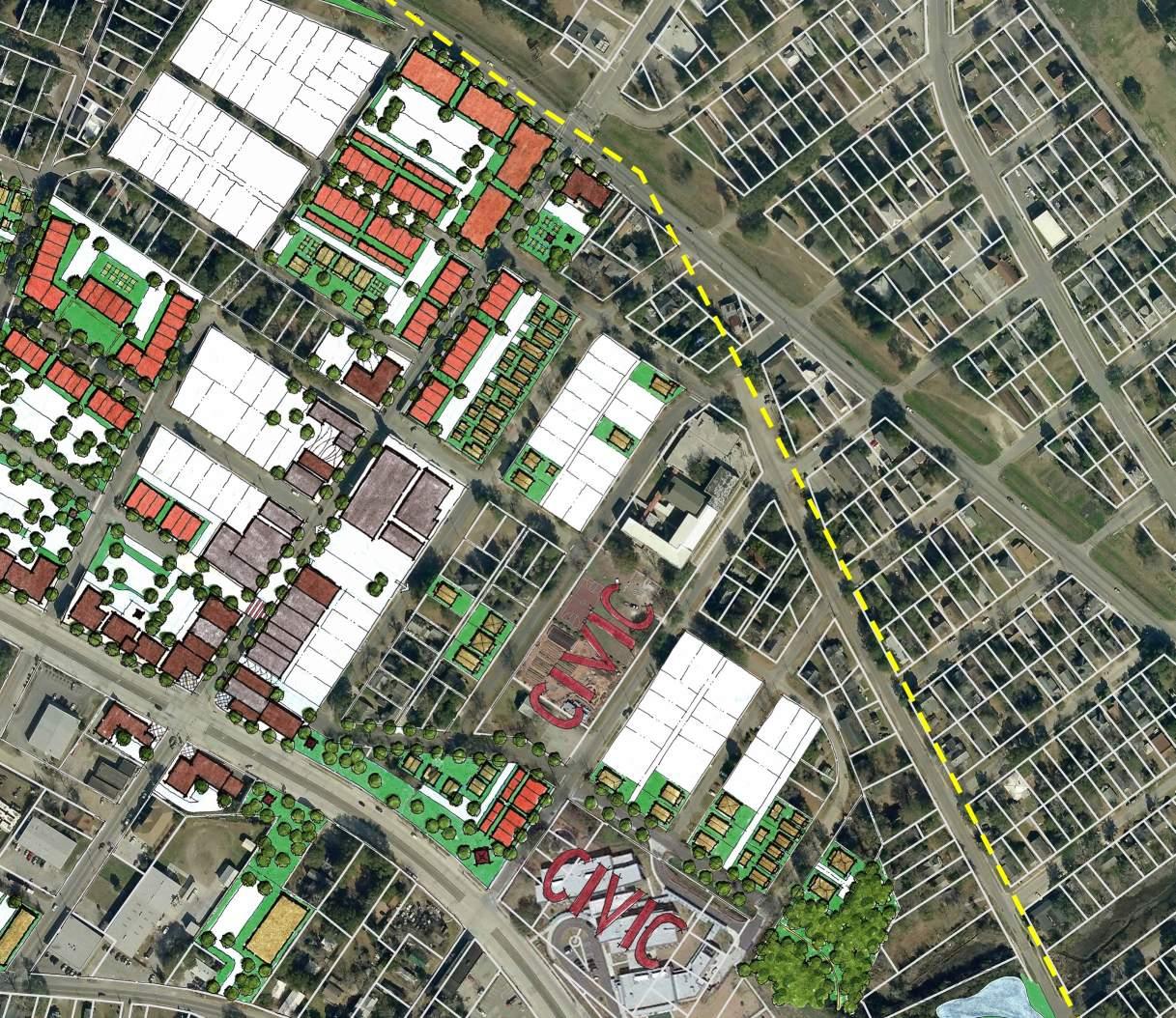
Mixed Use Infill (typical)
Linear Park
block crossing, and Rexton is envisioned as a curbless festival street for community events. Alternatives of this scenario are found on the next page and illustrate activation of the existing structures or a new mixed use building on the south side of the street with an active ground floor use and housing above.
Clemson University students and other community partners held a Better Block Event on Reynolds Avenue in the fall of 2018 and physically illustrated the idea of Rexton as a festival street; Image Credit: Clemson University
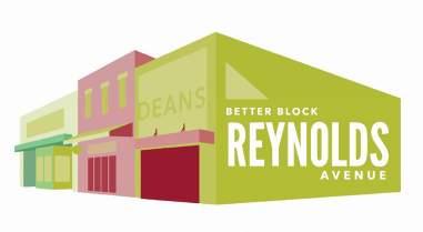
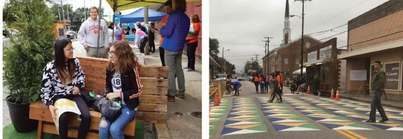
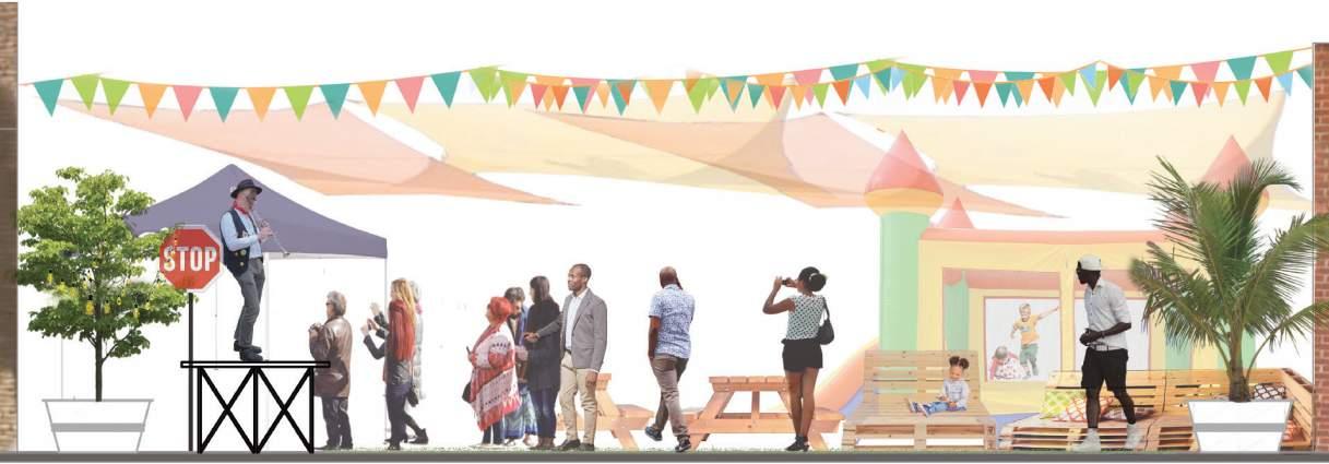
Proposed Concept A: Activation of buildings and hardscape enhancements along with seating and street trees
Proposed Concept A1: Space utilized as community festival closed to vehicular traffic with bollards
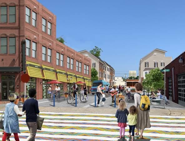
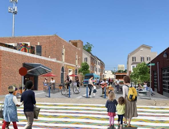
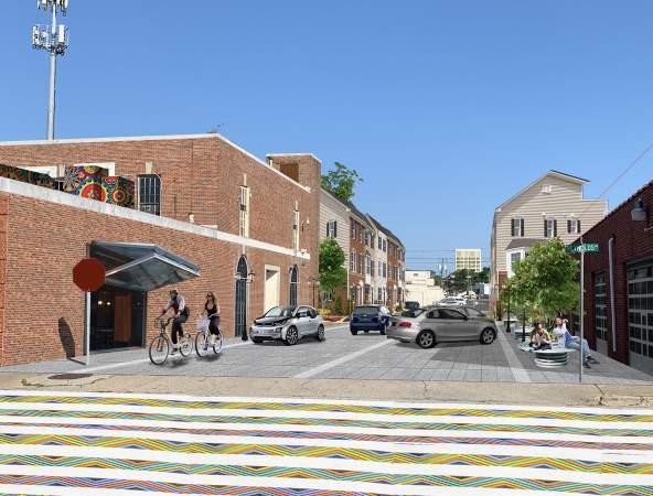
Proposed Concept B: Redevelopment of derelict structure with a mixed use building offering further activation
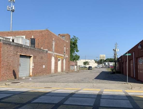
Moving northeast along Reynolds Avenue, a few more “gaps” in the frontage condition are infilled with new mixed use buildings to provide a continuous pedestrian experience (indicated with white circles). The new buildings along Reynolds and existing buildings planned for renovation should include residential units on the upper floors to begin to shape this into a truly urban district with a twenty-four hour population. As mentioned in 4.5.2, the police substation may be better suited within this area as well. The building located at the intersection of Reynolds and Ottawa is one option of a new police substation co-located within a mixed use building (indicated with police shield).
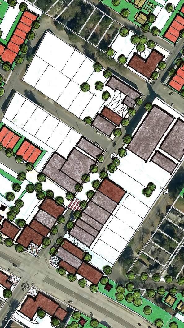
Existing Conditions: Looking southwest on Reynolds Avenue
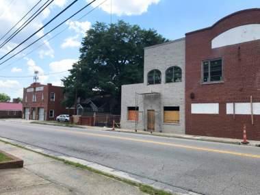
Proposed Concept A1: Renovation of existing buildings with active ground floor uses plus infill mixed use development, streetscape enhancements, and renovated public space
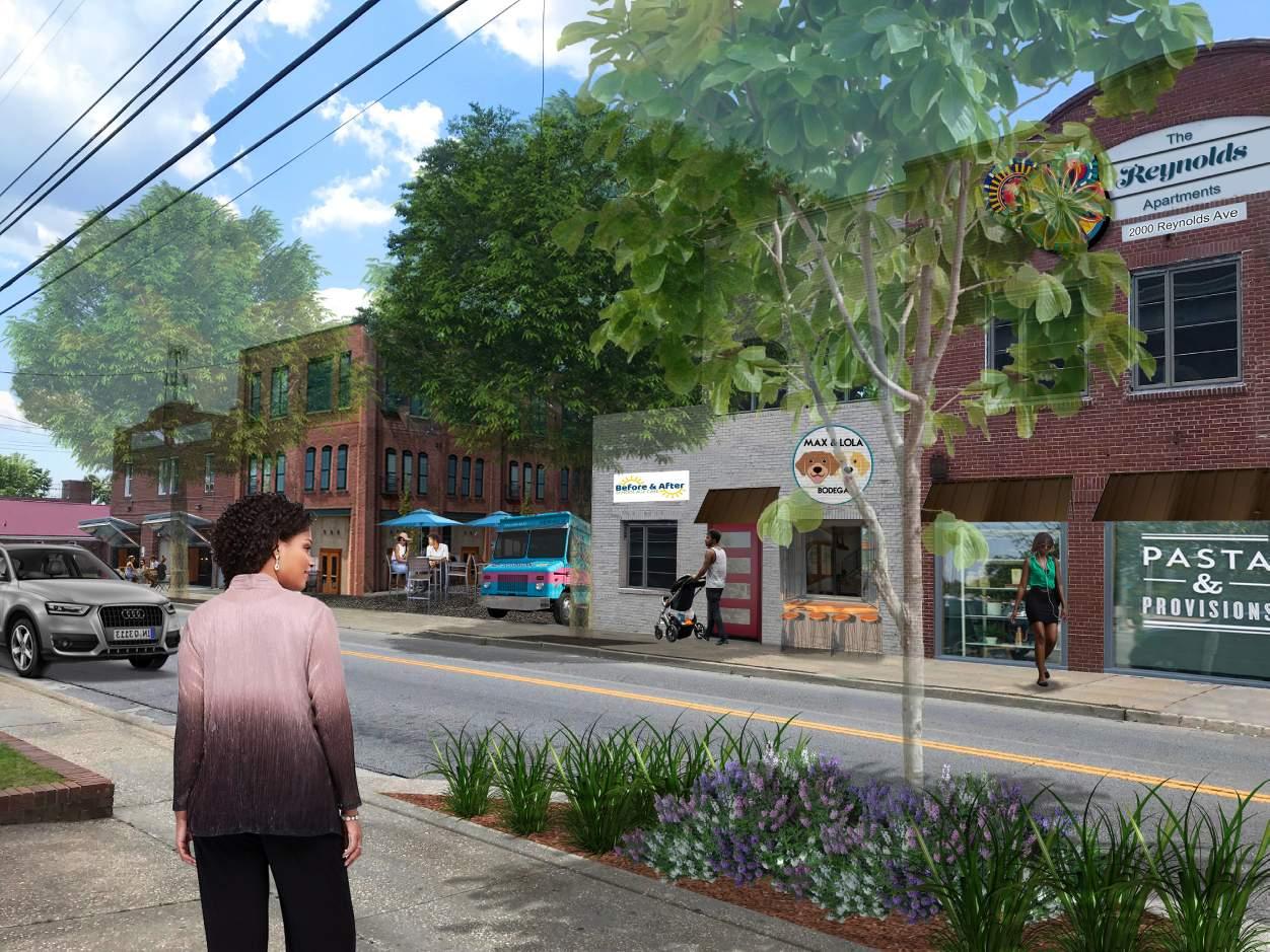
While much of this development will happen with private dollars and perhaps public/private partnerships, the one public investment that should be made is the enhancement of the streetscape. Several alternatives were explored during the design charrette as illustrated in the sections to the right. The photo simulations on the following pages explore two
options for enhancing the public realm in this area. Option A eliminates a few parking spaces and widens the sidewalk in “bulb-out” areas in order to plant substantial street trees, and Option B eliminates all on-street parking in favor of continuous fifteen foot sidewalks on both sides and a regular planting of street trees along Reynolds Avenue.
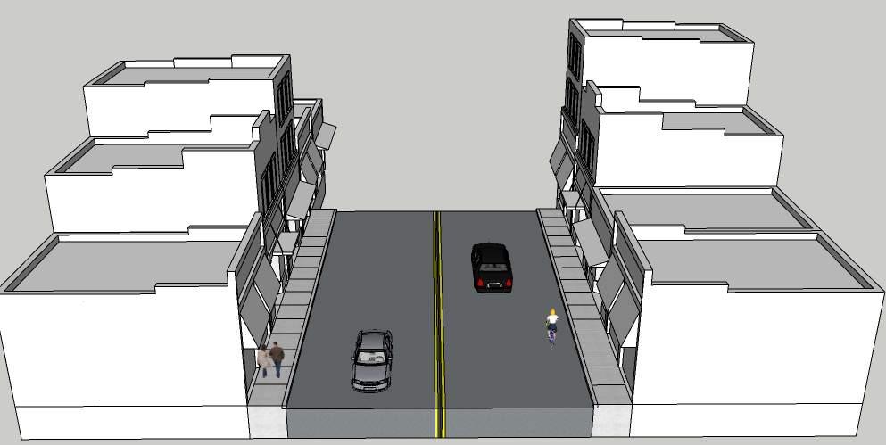
Proposed Reynolds Section A: Intermittent sidewalk extensions with street trees in wells and parallel parking (Rivers to Atlantic)
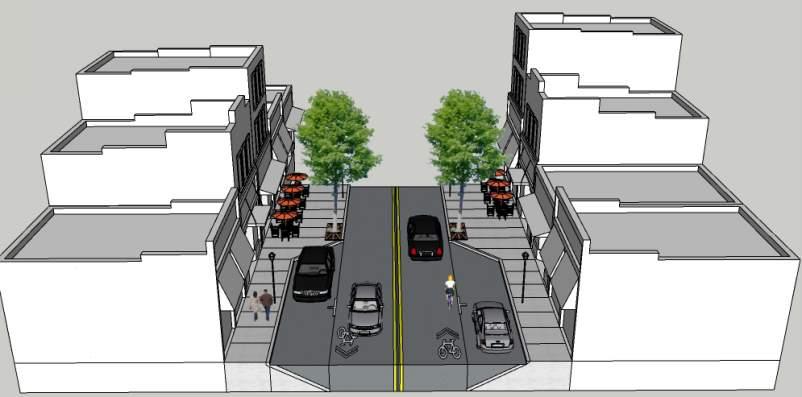
Proposed Reynolds Section B: Sidewalks extended to 15’with street trees in wells; all on-street parking removed (Rivers to Atlantic)
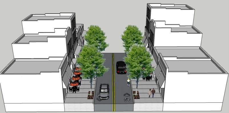
Existing Conditions looking south on Reynolds Avenue
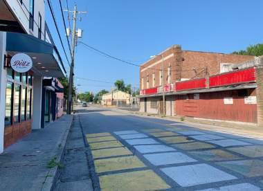
Proposed
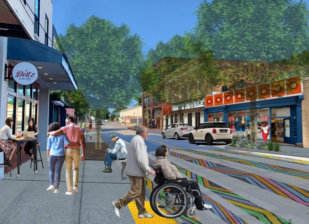
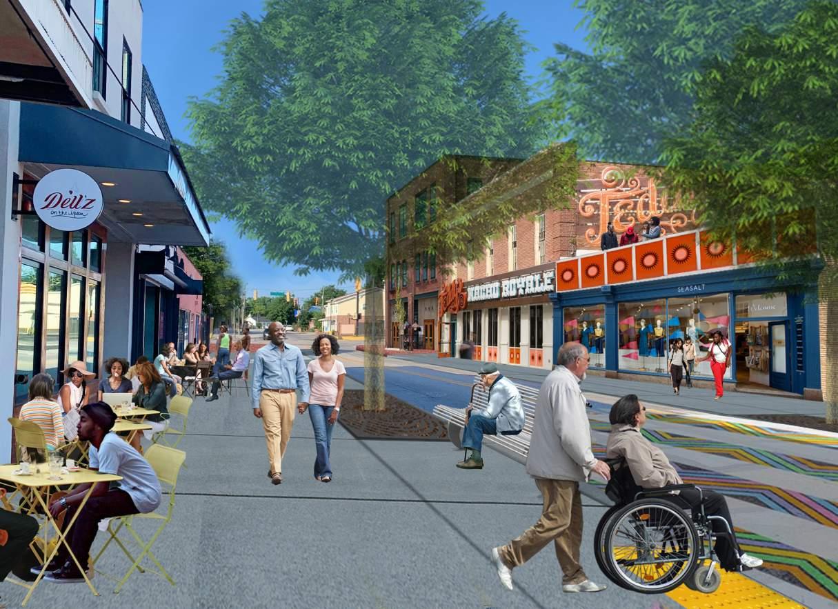
North of Atlantic Avenue, proposed multi-family housing contributes to the density of people living within an easy walking distance of the core and provides a logical transition into the neighborhoods. Spruill is planned to be a major biking route for the Neck Area. With that in mind, the brownfield site located at the intersection of Reynolds and Spruill Avenues is envisioned as a neighborhood marketplace and sandwich shop utilizing fresh ingredients from Fresh Future Farm as illustrated in the graphic which follows on the next page. New apartments are located across Reynolds Avenue from this development in a similar pattern to those found just northwest up Spruill Avenue. Gateway signage and high quality crosswalks should be installed in this area. The original mural found on the historic Chicora Elementary School is shown as an inlay in the center of the intersection.
Precedent example of townhomes envisioned along Reynolds Avenue between Atlantic Avenue and Florida Avenue; Glenwood Park, Atlanta, GA
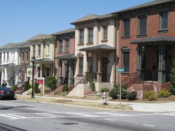
Precedent example of a community garden proposed for the neighborhood market at the intersection of Spruill and Reynolds Avenues; St. Louis, MO (US Marines helping work the garden)
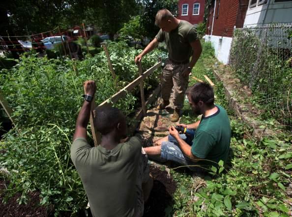
Existing Conditions: Reynolds and Spruill Intersection
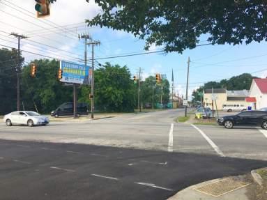
Proposed Concept: New neighborhood market and sandwich shop, enhanced gateway signage and intersection treatment, plus new apartments
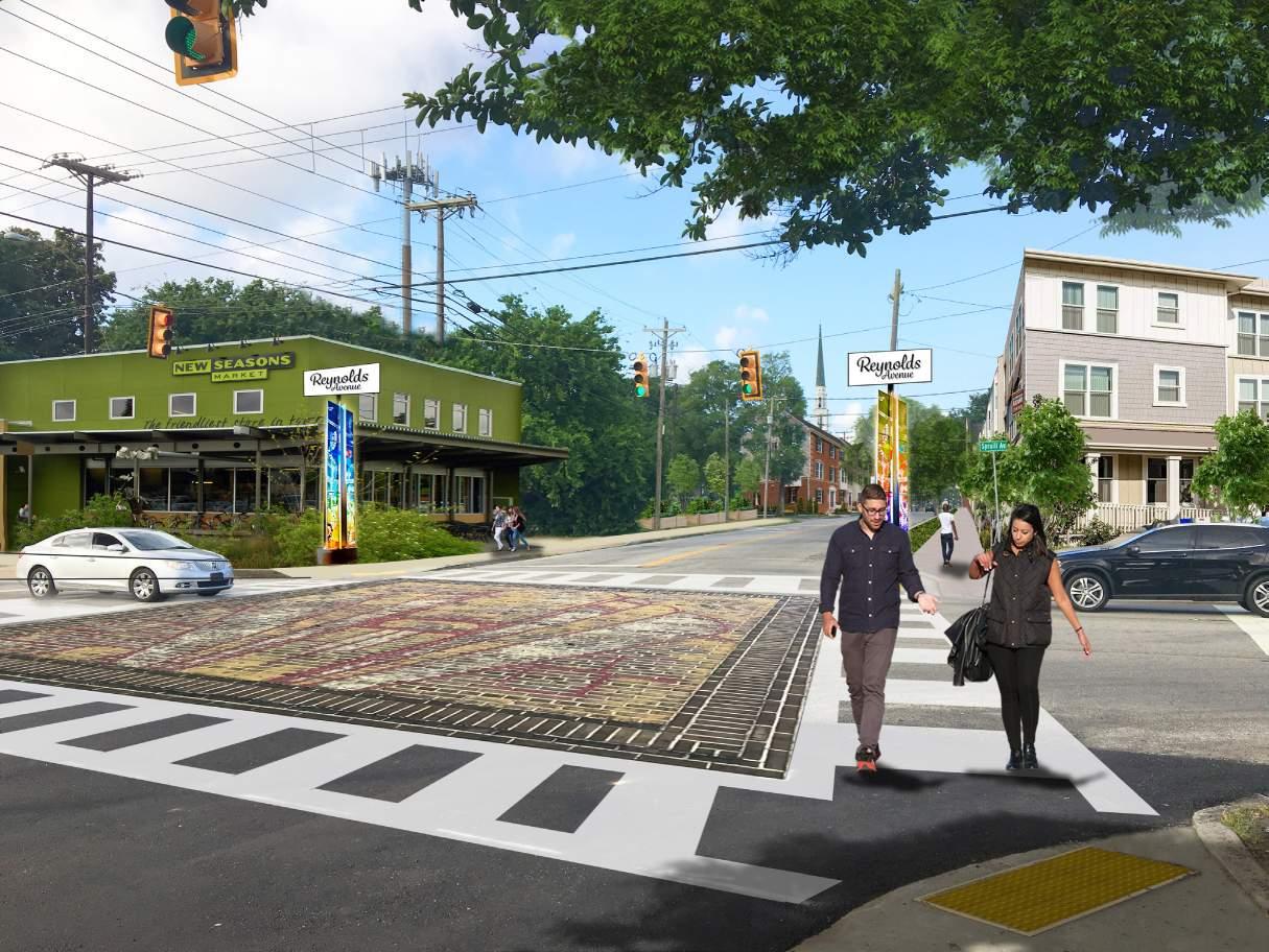
Housing infill in the surrounding blocks takes the form of both strategic infill around existing stable homes along with entire blocks of redevelopment. When an entire block is in need of redesign such as the Grayson block between Florida Avenue and Atlantic Avenue, the pattern illustrated is a mixed income strategy of narrow lot single family. This is in keeping with the more stable homes across the street and reknits the neighborhood fabric back together; this strategy also provides higher density which includes accessory dwelling units, an affordable housing typology. The homes within the proposed block vary in depth and interior finishes to make the mix of price points possible. The sporadic infill in surrounding blocks would look similar to the adjacent homes; however, what may look like a large single family home may actually be two, three, or even four units in the same structure. The goal for housing in this area is to increase density with quality infill at a range of prices while respecting the historic neighborhood scale.
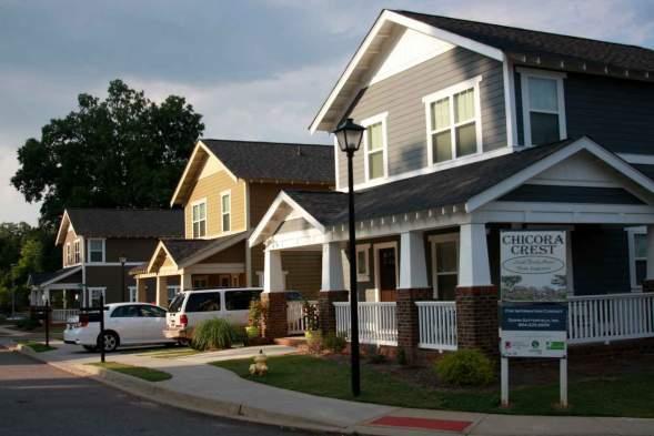
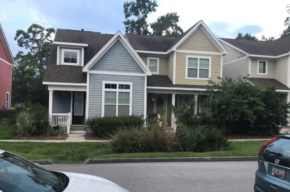
As mentioned in 4.1.1, the historic Chicora Elementary School on Success Street is currently awaiting its renovation into a community facility that will include a performing arts center, artist loft spaces, and an early childhood learning facility. The transformation will be a key component of this focus area’s success. This site in combination with the Main Street environment of Reynolds Avenue, stabilization of the neighborhood housing stock, the community churches, and the new Chicora Elementary School on Carner Avenue will all work together to create a vibrant, walkable community. Ensuring the neighborhood streets between all of these assets are safe will be a key to the success of this district.
Keys to Success:
» Embrace Rexton Street as a festival street with paving enhancements, bollards, and other people-centered amenities.
» The City of North Charleston should request ownership of Reynolds Avenue from SCDOT and invest capital dollars in the streetscape ensuring the project expands the sidewalk space for significant street trees and outdoor dining opportunities.
» Acquire properties to provide public parking and develop shared parking agreements with the churches in the area.
» Move the police substation to Reynolds Avenue into a new mixed use building constructed through a public-private partnership.
» Attract development to fill in the gaps of Reynolds Avenue with high quality mixeduse buildings that require ground floor active uses and upper story office and/or residential.
» Create an affordable housing action plan and ordinance.
» Create a conservation bank or land trust to preserve blocks and homes that can be renovated or rebuilt as affordable housing.
Safe routes to school should be a priority in the Chicora/ Cherokee neighborhood
» Address neighborhood street improvements to ensure safe walking and biking between community assets.

The area where Rivers Avenue meets Carner Avenue is a bit of a “no man’s land” today with an abandoned warehouse vibe and confusing traffic patterns.
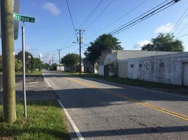
Carner Avenue is home to the Military Magnet Academy campus along with a City of North Charleston civic campus. Multiple brownfield sites are located along Rivers Avenue in this area with various contamination issues. The City has plans to expand their presence on the property where a new fire station was recently constructed. These plans include a recreation center, multiple ballfields, and other public amenities. The route of the bus rapid transit in this location is uncertain and could continue along Rivers over the railroad tracks or could take Carner Avenue south toward Downtown Charleston.
The development pattern of flex/employment space areas is expanded upon in the concept design to include more “flex” warehouse space. The intent is to create a true hub of employment opportunities. The additional flex space complements the existing buildings and creates shared parking opportunities and synergy between co-located businesses. Existing buildings in this district can be activated by incubator businesses looking for affordable space to test ideas and products.
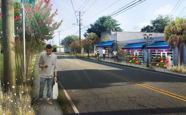

An impressive pedestrian bridge is envisioned to provide a safe crossing over the multiple railroad tracks for residents of the Accabee neighborhood so they can access both the employment hub and the civic campus amenities. Further discussion of this bridge can be found in 4.5.5. Another pedestrian connection to this area of Rivers is envisioned through Quitman Creek from Spruill Avenue to Chicora Avenue and onto the civic campuses. As previously mentioned, Spruill will become a major biking route, and the addition of this boardwalk will provide access to Rivers Avenue via a safe, tranquil route.
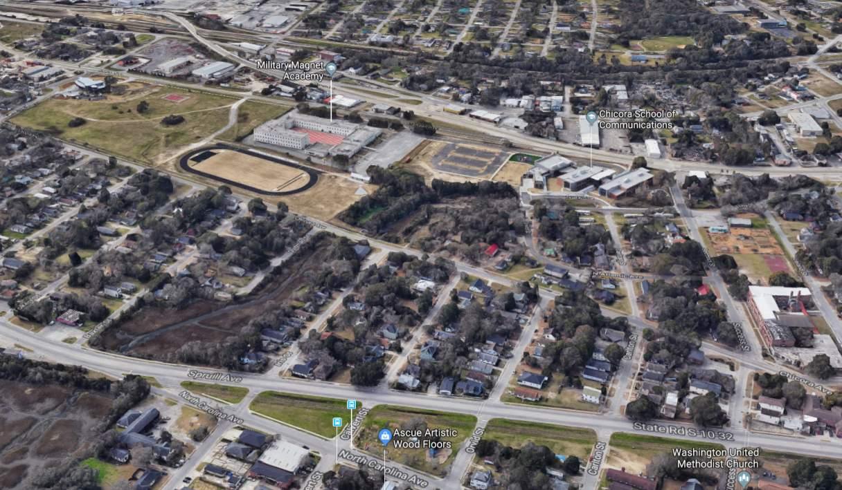
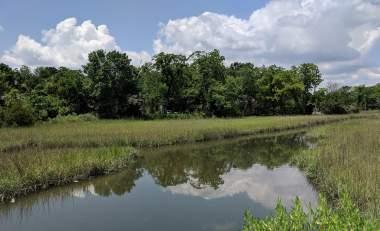
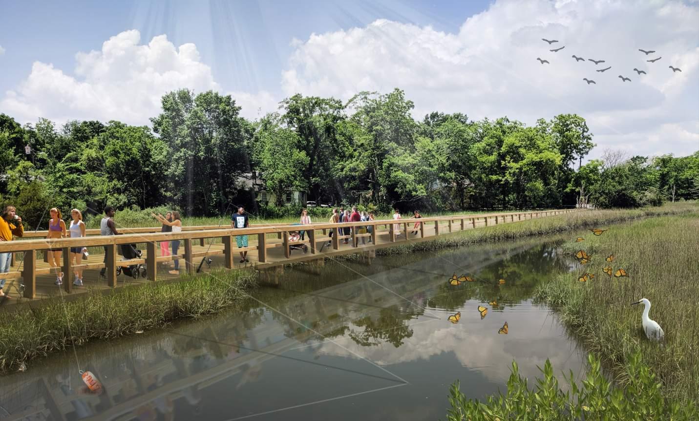
Street improvements in this focus area include planting street trees and adding sidewalks. One major consideration is the consolidation of Rivers Avenue, Carner Avenue, and the entry to the Military Magnet Academy with a roundabout. Other connecting roadways including Meeting Street Road would then safely enter Rivers and Carner at “T” intersections. For riders of the bus rapid transit system, this roundabout would become the true southern gateway into North Charleston and be accented by beautiful landscaping and public art.
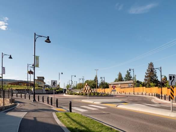
As mentioned throughout the focus areas, the linear space along Rivers is envisioned to have a safe multi-use pathway that can, in some areas, simply be a wide sidewalk. However, in areas such as the intersection of Rivers and Carner, a generous green edge should be provided with additional plantings and a winding pathway. The intent would be to connect the City’s Recreation and Civic Campus at the Chicora Tank Farm, the proposed Flex Employment Hub, Chicora Elementary School, Military Magnet Academy, the historic Chicora campus’ future amenities, Reynolds Avenue, and eventually, the transit-oriented development at McMillan.
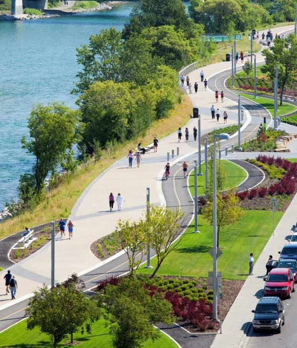
Keys to Success:
» Attract additional flex development to the area to create a true employment hub.
» Consider a roundabout as a solution to multiple roadways intersecting at odd angles and also as a southern gateway feature for the City of North Charleston.
» Create safe connections to the civic campus from all surrounding neighborhoods.
» Develop pockets of green infrastructure along Rivers Avenue where possible and enhance with winding multi-use paths and landscaping.
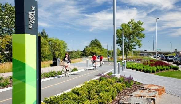
The Accabee Neighborhood currently feels disconnected from the Rivers Avenue area because of barriers that include the railroad and lack of safe pedestrian connections along the roadways.
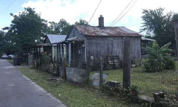
The Accabee Neighborhood is home to the Mary Ford Elementary School campus and the Perry Webb Community Center. The housing conditions are quite varied with abandoned homes and empty lots directly adjacent to well cared for cottages. The street grid is well-connected, but the roadways are curbless with no sidewalks. An environmental overlay of the neighborhood shows much of the area is prone to flooding.
With a windshield survey of the housing conditions in hand, the plan identifies infill opportunities within the existing block structure. Special Flood Hazard Area construction standards should be adopted and followed that require specific requirements to protect structures, contents, and occupants during a flood. Also, builders must use FEMA’s base flood elevation (BFE) to determine the height of the first habitable floor of structures within the new infill development.
Low impact stormwater standards will also be key to developing in this sensitive flood zone area. Permeable pavement, naturalized drainageways, rainwater harvesting, and bioretention should all be utilized.
The plan identifies Appleton Avenue, Easton Street, and Baker Avenue as priority streetscape improvement corridors suitable for the addition of street trees and sidewalks. Ultimately, providing sidewalks throughout the neighborhood would be ideal, but these three improvements would create safer connections for pedestrians and cyclists to the larger community.
Pedestrian Bridge
Boardwalks and Wetland
Overlook
Infill Housing (typical)
Existing (typical)
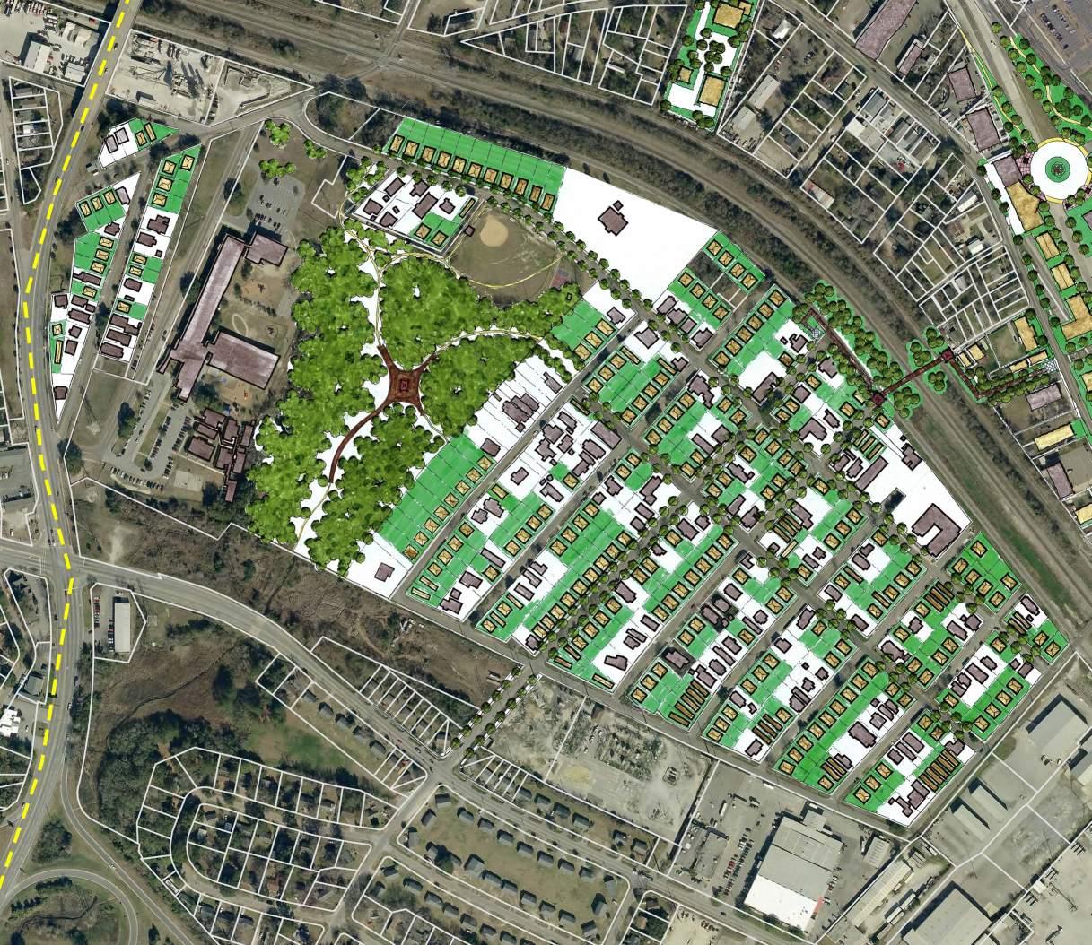
Along the theme of connectivity, a pedestrian bridge is illustrated accessed on Easton Street, ramping up toward Dover Street along the rail right-of-way, over the railroad tracks, and ramping down to Meeting Street Road via a narrow easement. Neither railroad crossing into Accabee (Misroon Street & Accabee Road) currently has sidewalk connections for pedestrians. This crossing is centrally located within the neighborhood and utilizes an existing power easement over the railway. Current and future residents of Accabee would be able to utilize the bridge to access the flex employment hub and the civic campus off of Rivers Avenue along with the bus rapid transit system.
The $4 million Met Branch Trail Pedestrian Bridge constructed in 2014 provides a direct connection between a local community and a transit center; the bridge spans a busy freight and passenger rail corridor in Washington, D.C. | Photo courtesy Washington Area Bicyclists Association
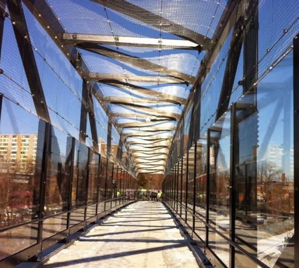
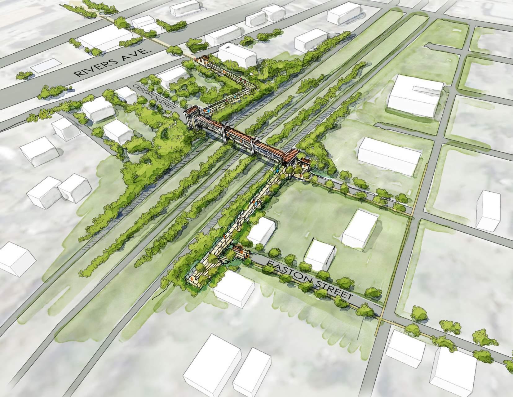 Birdseye rendering of proposed pedestrian bridge connecting the Accabee Neighborhood to Rivers Avenue
Existing Conditions looking south on Misroon Street heading into the Accabee Neighborhood
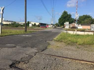
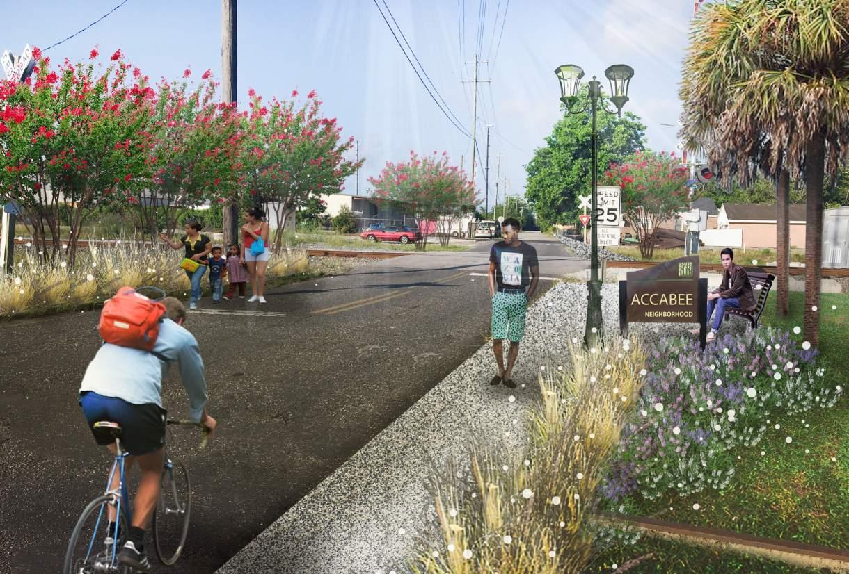
Wetlands and creeks run between the neighborhood and Mary Ford Elementary’s campus, and the concept plan proposes pedestrian boardwalks through the area to highlight this natural amenity for education and recreation purposes. A significant overlook is centrally located and could be utilized as an outdoor classroom or simply a passive recreation amenity for bird watching.
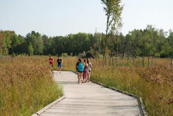
The campus of Mary Ford Elementary is also a large publicly owned property that could be redeveloped in the future as higher density housing and neighborhood scale mixed use for the residents in both Accabee and other neighborhoods south of the railroad tracks.
Keys to Success:
» Study the feasibility of a pedestrian bridge connecting the Accabee Neighborhood over the railroad tracks to Rivers Avenue.
» Promote sensitive infill housing in the Accabee Neighborhood in a range of price points.
» Adopt special flood hazard area zoning and building standards for the neighborhoods impacted by flooding.
» Select and prioritize streetscape projects in the Accabee Neighborhood to create safe routes for pedestrians and cyclists.
Precedent image of a wetland access boardwalk; Moses Creek Wetland Mitigation, Stevens Point, Wisconsin
» Create opportunities for the public to enjoy the natural features of the area including the wetland area behind Mary Ford Elementary School.
THIS PAGE WAS INTENTIONALLY LEFT BLANK
6.1 INTRODUCTION
6.2 FOCUS SITES AND RECOMMENDATIONS
The comprehensive and multi-disciplinary approach of the brownfields AWP planning process for the Rivers Avenue Corridor will allow BCDCOG, City of North Charleston, Charleston County, and City of Charleston to be much more strategic about its allocation of brownfield resources. The five focus sites identified will play a pivotal role in the future development of Rivers Ave. Corridor as they are positioned in key areas of targeted land use. As discussed in chapter 4, the current land use associated with the focus site areas include:
» Focus Site #1: Institutional
» Focus Site #2: Major Business/Retail
» Focus Site #3: Major Business/Retail
» Focus Site #4: Major Business/Retail
» Focus Site #5: Institutional
The South Carolina Department of Health and Environmental Control’s Brownfields program has a Non-Responsible Party Voluntary Cleanup Contract (NRP-VCC). The NRP-VCC program allows a nonresponsible party to acquire a contaminated site with State Superfund liability protection for existing contamination by agreeing to perform an environmental assessment and/
or remediation. The environmental assessment typically involves the collection of soil, groundwater, segregated sources, sediment, and/or surface water. After completion of the negotiated work in the Voluntary Cleanup Contract, the purchaser receives State Superfund liability protections for the past contamination. The Voluntary Cleanup Contract protections also pass onto the non-responsible party’s lenders, signatories, parents, subsidiaries, and successors.
A purchaser that obtains an NRP-VCC must conduct some environmental assessment, per SCDHEC’s discretion. Following the assessment, SCDHEC may require response actions such as soil removal, capping, soil management plans, etc. Various funding mechanisms are available to conduct these evaluations. EPA Brownfields Assessment Grants provide funds to communities and non-profits to inventory and assess brownfield sites. The grant process is very competitive, but there is no match for the grant funds. The typical grant provides $300,000 to inventory, conduct Phase I and Phase II Environmental Site Assessments, and conduct clean-up planning. Grant applications are typically due in November-December and awardees are announced in May.
If cleanup/remediation is required, two main funding opportunities are:
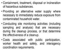
• The EPA Brownfields Cleanup Grants
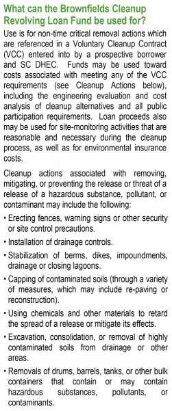
• The SCDHEC Cleanup Revolving Loan Fund
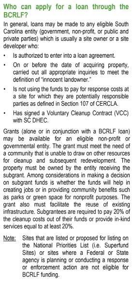
EPA Cleanup Grants are competitive, and applications are due in November-December and awardees are announced in May. The Cleanup grants allow eligible entities to apply for up to $200,000 per site. Cleanup grants do require a 20% cost share, which can be in the form of a contribution of money, labor, material, and/or services. One caveat of the cleanup grants is that the applicant must own the site at the time of application.
The SCDHEC Brownfields Program also has Cleanup Revolving Loan Funds available to finance environmental cleanup and removal activities. The Cleanup Revolving Loan Funds are funded by a grant from the USEPA to the SCDHEC. The Catawba Regional Council of Governments is the fund manager for the program. The Fund allows for local governments, businesses, non-profit organizations, and public and private parties to apply for funding as long as they are a non-responsible party performing a removal action under the Voluntary Cleanup Contract program. For non-profits and governmental borrowers, up to 30% of the loan may be forgiven. For-profit borrowers may be eligible to receive the loans at below market interest rates.
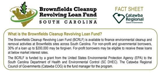
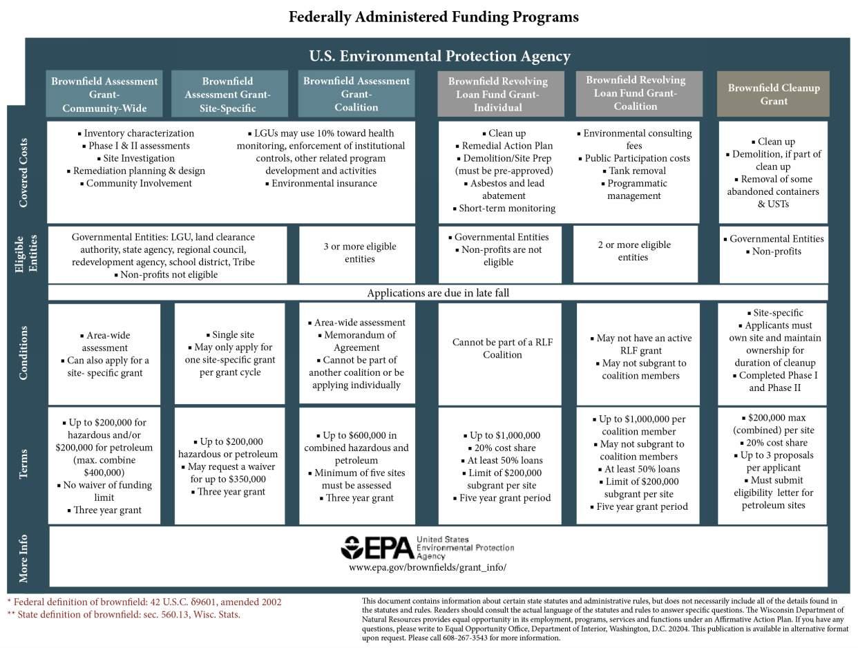
Annual competitive grant program that provides funding for completing inventories, performed environmental assessment and remedial/reuse planning, and outreach for brownfields (either individual sites or mutliple sites throughout a city, county, or other area). Higher grant awards are available to 3 or more local governments that apply as "coalitions."
https://www.epa.gov/bro wnfields/typesbrownfields-grant-funding
Can apply for funding for assessment of a single site, or for a community-wide project focused on multiple sites within one or more target areas. Sites must be brownfields for which the grantee or other parties are not legally responsible for the specific assessment or planning activities performed using grant funding. Except for grants focused on single sites, the specific sites on which funding will be used does not need to be known at the time of application submitted. Eligible sites can include those owned by local units of government or private entities.
Approximately $33 million. (145 grants totalling $33.5 M were awarded in the FY18 competition)
$300,000 (for individual sites or community-wide assessment projects for individual local units of government). $600,000 for coalitions of 3 or more local units of government.
No match required. Competition guidelines are released approximately 60 days before the submittal deadline. Required format varies from year to year.
Deadline in 2019 will likely be in Dec.
(Deadlines in recent grant competitions have been 1/31/19, 11/16/17, and 12/20/16).
Grant awards are typically announced in May of following year, with the start date for a 3-year cooperative agreement period beginning on Oct. 1.
https://www.epa.gov/bro wnfields/typesbrownfields-grant-funding
Annual competitive grant program that provides funding for environmental cleanup of brownfields. Cleanup can include soil, groundwater, or soil vapor mitigation, as well as abatement of hazardous building materials.
Sites must be brownfields owned by applicant at the time of application submittal, and for which they (or other financially viable parties) are not responsible for cleanup. Can be used for projects focused on economic or non-economic benefits.
Approximately $8 million. (38 grants totalling $7.5 M were awarded in FY18 competition)
Increased to $500,000 in FY2019. Applicants can apply for only 1 grant each year.
20% match (can be waived in certain circumstances) and/or met through inkind services or materials
High level of effort (typically >200 hours)
Highly competit rate (including a revised and resu for local govern multiple brownfi challanges and relatively high nu disadvantaged closely aligned brownfield is fair is no documente use but "underut
USEPA Brownfields
Environmental Workforce Development and Job Training (EWDJT) Grants
https://www.epa.gov/site s/production/files/201603/documents/final_ewdj t_tri-fold_brochure_7-3015_0.pdf
Annual competitive grant program that provides funding to allow nonprofit and other organizations to recruit, train, and place predominantly low-income and minority, unemployed and under-employed people living in areas affected by solid and hazardous waste. Residents learn the skills needed to secure full-time, sustainable employment in the environmental field, including assessment and cleanup.
The grants fund training programs (see website link for examples of the types of training)
Approximately $3 million. (17 grants totalling $3.3 M were awarded in FY18 competition)
Competition guidelines are released approximately 60 days before the submittal deadline. Required format varies from year to year.
$200,000 No match required. Competition guidelines are released approximately 60 days before the submittal deadline. Required format varies from year to year.
Deadline in 2019 will likely be in Dec. (Deadlines in recent grant competitions have been 1/31/19, 11/16/17, and 12/20/16).
Grant awards are typically announced in May of following year, with the start date for a 2-year cooperative agreement period beginning on Oct. 1.
TBD. Deadline for most recent competition was 12/15/2017.
Grant awards are typically announced in May of following year, with the start date for a 3-year cooperative agreement period beginning on Oct. 1.
High level of effort (typically 100-150 hours)
Highly competit rate (including a revised and resu for multi-parcel multiple grants ( grant eligible "sit maximum grant implement this c overall number degree of comp
High level of effort (typically 100-150 hours)
Five brownfield sites in the corridor have been identified as focus sites (see Figure 2.1 depicting the five focus sites). Each of these sites meets the definition of a brownfield. The five sites were chosen based on their redevelopment potential and likelihood to catalyze additional revitalization projects in the corridor. A detailed description of each focus site is provided below.
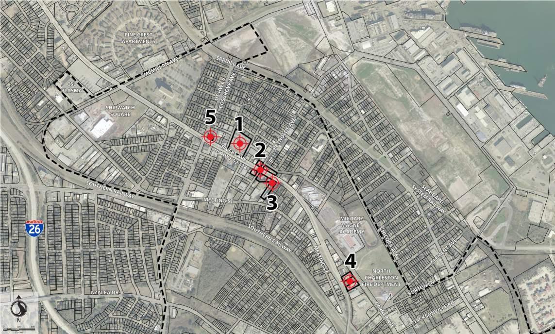
Site Description:
Focus Site #1 is the 3+ acre former Carolina Coin and Dry Cleaning, Inc. facility located at 3346 Rivers Avenue, as shown in Figures 2.2 and 2.3 (Focus Site #1). The site is one of the largest brownfield sites in the corridor and its location on Rivers Avenue is in a high-visibility area. The site is occupied by a series of six adjoined buildings constructed at different times in the 1950s and 1960s. Historically, the building was actually listed by multiple addresses, including 3326, 3328, 3334, 3338, 3340, 3342, 3344, 3346, 3348, and 3350 Rivers Avenue.

The site is developed with an approximately 40,500 square foot structure occupied by the South Carolina Child Support and Social Services office. In addition to DryClean USA Coastal, Inc., multiple dry cleaners occupied the structure, including at 3326 (Quick As a Wink), 3328 (One Hour Valet Cleaners), and 3346 (Carolina Coin Laundry and Drycleaning), which operated between 1969 and 1992. Based on available city directory information, dry cleaners likely occupied the two easternmost buildings in the complex.
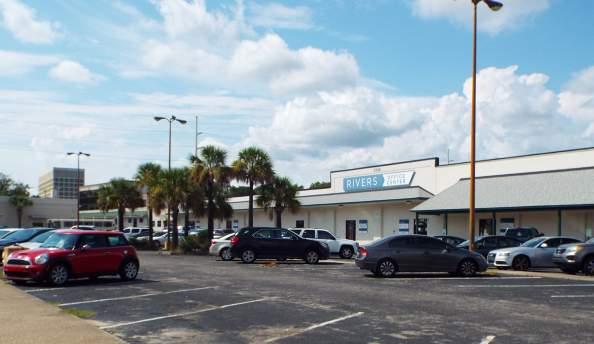
Assessments began at the facility in 2016 under the direction of SCDHEC as part of Drycleaning Facility Restoration Trust Fund program. An Expanded Initial Assessment was completed by Ecology and Environmental, Inc. that included an investigation of site soils, groundwater, and indoor air quality. Dry cleaning solvents were detected above applicable screening concentrations in site soil (tetrachloroethylene), groundwater (tetrachloroethylene, trichloroethylene, cis-1,2-dichlorothylene, and vinyl chloride), and indoor air (tetrachloroethylene). A resampling of indoor air confirmed concentrations of tetrachloroethylene above its screening level for commercial buildings.
Further assessment of the DryClean USA Coastal, Inc. facility is warranted, including an expanded assessment of indoor air quality at the structure. However, based on the results of the initial assessments, future re-use and/or redevelopment of the facility must address the presence of dry cleaning solvents, including:
• If the current structure is to be used in the future, it may be necessary to install a vapor intrusion mitigation system to facilitate removal of contaminants in indoor air.
• New development on the site must take into account the presence of contaminated soil and groundwater at the facility. Due to a shallow groundwater table, groundwater may be encountered during construction; contaminated soils may need to be removed from the site if disturbed during the construction process; and new structures may require a vapor mitigation system.
Sampling and assessment for lead-based paint and asbestos containing material will also be required prior to any demolition or renovation of the current structure. Lastly, it is well-documented and understood by SCDHEC that South Carolina soils contain elevated concentrations of naturallyoccurring arsenic. Background concentrations for arsenic have been established and any additional assessment would be compared to these concentrations, rather than nationwide screening levels.
Recommended Future Use:
Currently the land use of Focus Site #1 is institutional. The recommended future land use of the site, based upon our site analysis and our review of the market research done, is that it include mixed-uses of ground level office/retail with residents above along the planning corridor.
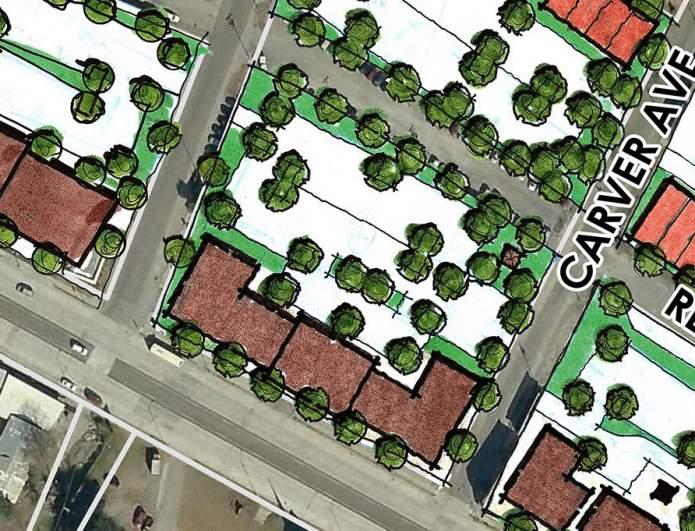
BROWNFIELD SUMMARY:
Environmental Concern Level:
HIGH MEDIUM LOW
Level of Data Uncertainty:
HIGH MEDIUM LOW
Site Description:
Focus Site #2 is comprised of four properties, each on a corner of the intersection of Rivers and Reynolds Avenues, as shown in Figures 3.1 - 3.5 (Focus Site #2). The four parcels total 1.25-acres and were once the southern gateway to the Reynolds Avenue commercial district. During the operation of the Charleston Naval Shipyard, Reynolds Avenue served as the main commercial district for the base, but quickly fell into more difficult times after its closure. Historically, four gasoline stations operated on the properties, one of which is still an active gas station. The properties at the Rivers and Reynolds intersection are at the heart of the study area and are situated at such a location to serve as a focus for additional redevelopment throughout the corridor.
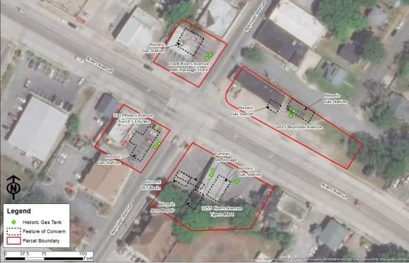
Brownfield Status:
3255 Rivers Avenue
3255 Rivers Avenue (Figure 4.2) is developed with the Tigers Market, an active gas station, which operates under UST Permit Number 01689. Sanborn Fire Insurance Maps depict the site with a gas station, oil storage area, and two gas tanks. Additionally, the western portion of the site was used for
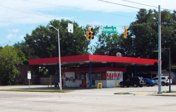
auto repair. The current development of the site includes four USTs, two of which are active. The active USTs are an 8,000-gallon premium gasoline and a 10,000-gallon regular. The remaining two are listed as “Extended Out-of-Use”. The site is also developed with four fuel dispensers. A release was reported at the Tigers Market in July 1986 and was assessed following the release. The release was issued a No Further Action (NFA) declaration from SCDHEC in April 2005.
The site is currently occupied by a viable business; however, its location at the entrance to the Reynolds Avenue commercial district makes the site a high priority for redevelopment in the future. If the site is to be redeveloped, the following environmental concerns would have to be addressed:
• Current USTs, underground piping and dispensers would have to be removed in accordance with SCDHEC UST Regulations.
• The soils around the USTs are likely contaminated from the prior release and would require excavation and disposal.
• The site was previously used to conduct auto repair activities. Releases associated with USTs are typically only assessed for petroleum constituents, and other volatile organic compounds (VOCs) and semi-VOCs (SVOCs) are not included in those assessments. Thus,
future assessment should include a more robust suite of analytes.
• The potential exists that an undocumented release to groundwater has occurred, which would require additional groundwater assessment. Thus, a detailed Phase II Environmental Site Assessment of site soils and groundwater would be recommended to delineate potential site impacts prior to redevelopment.
As with any building, an asbestos assessment will be required prior to renovation or demolition of the onsite structures. However, the assessment would be relatively minor, as the structure is quite small.
The remaining three corners of the intersection are 3303 Rivers Avenue (Figure 4.3), 3308 Rivers Avenue (Figure 4.4) and 2025 Reynolds Avenue (Figure 4.5). All three of the properties were historically developed with gas stations. However, the operation of these gas stations ceased prior to implementation of environmental laws and regulations for USTs; as such, SCDHEC has no data on the sites. The limited available environmental knowledge of these sites is summarized below.
the site with a gas station with two gas tanks, which is identified in City Directories as Beach’s Sinclair. The site operated from at least 1944 until the late 1960s. SCDHEC has no record of a gas station at this location, and there is no record of assessments conducted at the facility.
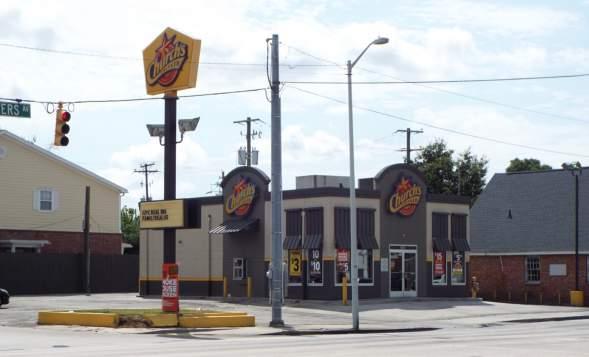
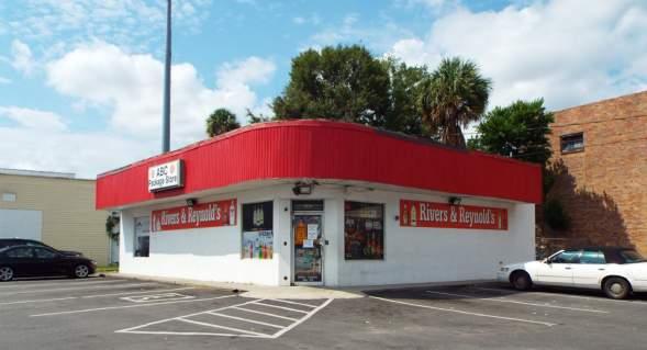
3308 Rivers Avenue is developed with a liquor store. Sanborn Fire Insurance Company maps depict the site with a gas station with two gas tanks between 1944 and 1955. City Directories dating back to 1958 did not identify a gas station at the address. SCDHEC has no record of a gas station at this location, and there is no record of assessments conducted at the facility.
2025 Reynolds Avenue is currently developed with a small structure that has seen frequent turnover in businesses. Over the past few years the structure has been occupied by restaurants and a convenience store. The parcel is currently identified as 2025 Reynolds Avenue, but historically the parcel also included 3238-3249 and 3252 Rivers Avenue.
A 1944 Sanborn Fire Insurance Company map depicts the northern portion of the site with a gas station with two gas tanks and the southern portion is depicted with a tire sales and service business. The 1951 map depicts the construction of an additional restaurant at the northeast corner of the parcel. By 1955, the filling station has moved to the former tire sales and service structure, while the northern portion
is developed with a structure that appears similar to the current structure. The only suspect listings in the City Directories are from 1958 which list the Domestic Gas Company, Inc. (3244 Rivers Avenue) and the Rivers Avenue Shell Station (3246 Rivers Avenue). SCDHEC has no record of a gas station at this location, and there is no record of assessments conducted at the facility.
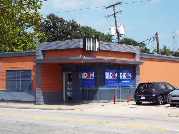
Due to the lack of environmental assessments of these facilities, if any of the three are going to be redeveloped, the path forward is similar. The only potential difference is the size and scope of assessment that is warranted. If the sites are to be redeveloped, the following environmental concerns should be addressed:
• Based on the lack of information, it is unknown if any USTs remain in the ground. Thus, an evaluation would be required to determine if USTs are still located in the ground at the facility. The evaluation can be conducted using a combination of non-invasive geophysical investigations, such as ground penetrating radar and high sensitivity metal detectors.
• If UST(s) are present, they would have to be removed in accordance with SCDHEC UST Regulations, including full closure assessments.
• A full soil and groundwater investigation should be conducted to evaluate if any contamination is present. As with any building, an asbestos assessment will be required prior to renovation or demolition of the onsite structures.
Recommended Future Use:
Currently the land use of Focus Site #2 is Major Business/ Retail. The recommended future land use of the site is that it include mixed-uses of ground level office/retail with residents above along the planning corridor and Reynolds Ave. Certain existing buildings in the area can be evaluated for adaptive reuse potential and pedestrian plazas should be incorporated at the corners in order to give the opportunity for gathering.
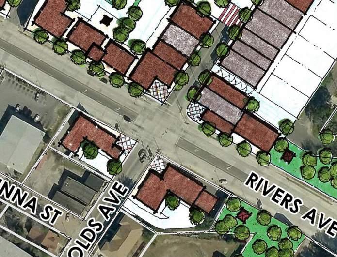
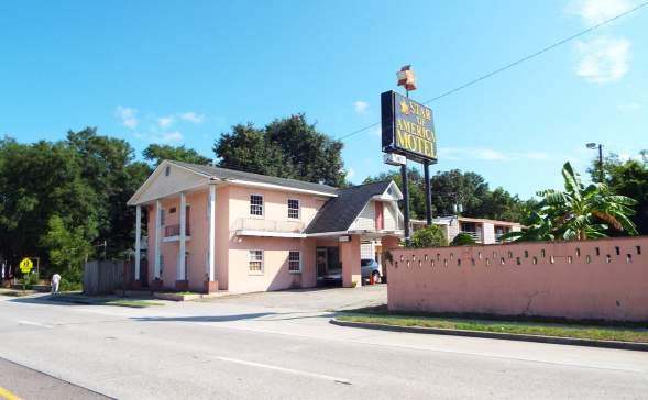
Site Description:
Focus Site #3 (Figure 4.1 and 4.2) is located at 3245 Rivers Avenue is 0.98-acres and is located immediately southeast of Focus Site #2. Focus Site #3 was selected due to: 1) its relatively large parcel size within the corridor; 2) its proximity to the Rivers & Reynolds Avenues intersection; and 3) its limited use and reputation as a community troublespot. Not only is the site located in the main commercial district of Rivers Avenue, but it also abuts an undeveloped tract to the south. The undeveloped tract is located on Meeting Street Road, another main corridor in the area. Thus, a larger redevelopment opportunity exists for both parcels with multiple means of ingress/egress to main corridors within the area.
Focus Site #3 is currently developed with the Star of America Hotel, a two-story structure containing approximately 20,000 square feet under roof. Prior to its development as a hotel, the tract was developed with at least six dwellings. The 1955 Sanborn Fire Insurance Company map depicts the parcel with a used auto sales facility, auto repair garage, and a dwelling. More recently, City of North Charleston Police Department responded to the presence of a clandestine drug laboratory, also known as a meth lab, at the Star of America Hotel. The former
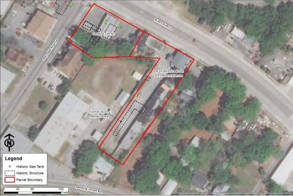
meth lab at the facility underscores the type of facility it has become in more recent years and its increasing blight on the community. Furthermore, the illicit production of methamphetamines utilizes a variety of chemicals of concern, and these chemicals are not typically handled with the normal standard of care afforded to handling hazardous materials in other commercial operations. Common production processes include use of volatile organic compounds, acids, bases, metals, and chemical salts. Common items seized during closure of a meth lab are acetone, alcohols, anhydrous ammonia, ether, hydrochloric acid, iodine, lithium, methanol, sulfuric acid, toluene, trichloroethane, and others.
Brownfield Status:
A variety of environmental concerns exist in association with the Star of America Hotel, which would have to be addressed during redevelopment of the site, including:
• Former use of the site for auto repair, which involves the use of petroleum products and other hazardous materials, such as solvents. A Phase II ESA assessment should be conducted in the location of the former auto repair facility, which should include soil and groundwater sampling.
• Although no releases were reported at the facility, it may be warranted to investigate the plumbing associated with the former meth lab, especially if the facility is on a
septic system (although this is unlikely). Obtaining police reports or information from personnel familiar with the meth lab may shed light on how materials may have been disposed during the lab’s operation.
• A potentially expensive environmental unknown is the presence/absence of asbestos containing materials. An asbestos inspection of the structure could be relatively expensive due to the size of the onsite structure and the number of individual rooms. If asbestos is present throughout the structure, abatement of the asbestos could be an expensive undertaking prior to demolition and redevelopment.
Recommended Future Use:
Currently the land use of Focus Site #3 is Major Business/ Retail. The recommended future land use of the site is flex/ employment space, which is multi-purpose work space. The surrounding uses complement this type of use because from this point in the planning corridor and further south this will be the predominant use type. Buildings in the area with this similar use type already can be evaluated for adaptive reuse.
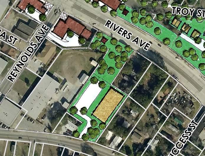
BROWNFIELD SUMMARY:
Environmental Concern Level:
HIGH MEDIUM LOW
Level of Data Uncertainty:
HIGH MEDIUM LOW
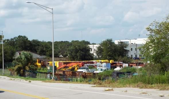
Focus Site #4 is located at 2867, 2873, and 2900 Rivers Avenue at the south end of the Corridor and totals approximately 1.6-acres. Focus Site #4 was selected as a focus site based on: 1) the site is the southern gateway into the corridor and highly visible from both the western adjacent Rivers Avenue and the eastern adjacent Carner Avenue; 2) the site is proximal to another brownfields site, the former Chicora Tank Farm, portions of which have been redeveloped; 3) the site is one of the largest undeveloped tracts in the Corridor, so a larger redevelopment project has the potential to be a catalyst for additional surrounding redevelopment; and 4) the site has mostly been used as a salvage yard or storage yard and is an eyesore.
Currently, the site is not developed with any structures; however, the site was previously developed with a body shop from at least 1955 until around 1994. The 1955 Sanborn Fire Insurance Company map depicts the site with an auto body shop with spray painting, and City Directories identify the site as Coleman’s Body Shop until 1994. Auto body shops use a variety of solvents, paints, and petroleum products. Since closure of the body shop, the site has mostly been used to store various vehicles, containers, and other materials. Aerial photographs depict the site as scattered with various debris and vehicles.
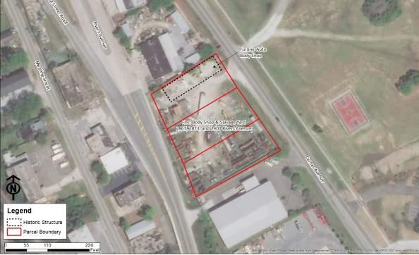
The facility is not listed in any regulatory databases and there is no record of any assessments being conducted. Regulatory records were requested for the site from SCDHEC, but they have no listings for the facility in their system. Due to the unknown nature of the debris stored on the site throughout the years, the potential exists for a variety of spilled chemicals of concern; thus, additional assessment is warranted to investigate a wide range of potential contaminants. Prior to redevelopment of the site, the following should be evaluated:
• A Phase II ESA, including the collection of soil and groundwater, in the location of the former auto bodyshop located near the northern property boundary. Additional assessment should be conducted throughout the parcel to evaluate potential impacts from the use of the facility as a salvage yard.
Recommended Future Use:
BROWNFIELD
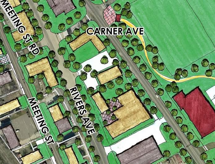
Site Description:
Focus Site #5 is located at 3376 Rivers Avenue at the intersection of Rivers Avenue and Cosgrove Avenue and is approximately 0.20-acres in size. Cosgrove Avenue is the main entrance to the corridor from the west and, thus, Focus Site #5 is a prime location for redevelopment visibility. The site is currently a CARTA bus stop, but as the Bus Rapid Transit (BRT) is implemented in the region, the bus stop will move from this location. Therefore, the site will be available for redevelopment after the relocation of the bus stop.
Brownfield Status:
Historically, the site was developed with a Gulf Oil Station which operated under UST Permit Number 14371. Gulf Oil previously operated five USTs at the site, three of which were removed from the site between 1976 and 1979, and the remaining USTs were removed in 1991. A release was reported in December 1991, at the time the two remaining USTs were removed. Initial assessments conducted in April 2001 identified petroleum and lead impacts to both soil and groundwater at the facility. In assessments conducted between 2012 and 2014, petroleum compounds were identified below applicable standards, and the site was issued a No Further Declaration by SCDHEC.
Although the site has been issued an NFA by SCDHEC, if redeveloped, additional assessment is warranted to
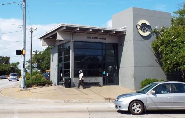
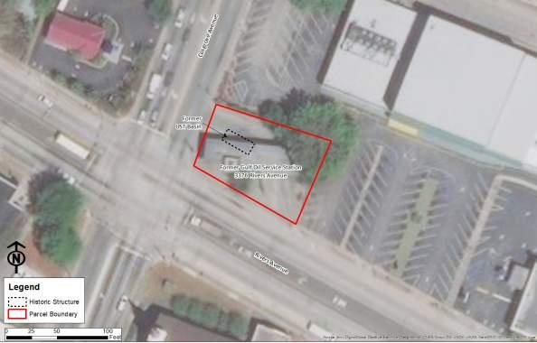
evaluate potentially contaminated soil and/or groundwater. Redevelopment would require excavation for utilities and foundations, and contaminated soil from the prior groundwater impacts could be encountered. If encountered, contaminated soils may have to be removed from the site and clean fill material brought to the site as part of redevelopment.
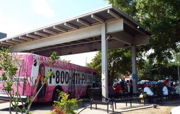
As with any building, an asbestos assessment will be required prior to renovation or demolition of the onsite structures. However, the assessment would be relatively minor, as the structure is quite small.
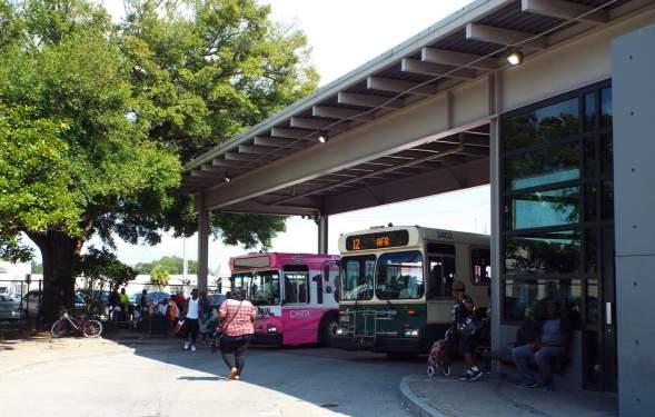
Recommended Future Use:
The current land use of Focus Site #5 is Institutional. The recommended future land use of the site is mixed-use. This portion of the planning corridor will be comprised of this same use typology facing Rivers Ave.
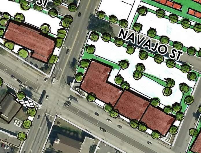
BROWNFIELD SUMMARY:
Environmental Concern Level:
HIGH MEDIUM LOW
Level of Data Uncertainty:
HIGH MEDIUM LOW
THIS PAGE WAS INTENTIONALLY LEFT BLANK