2 minute read
Alaska Highway Access


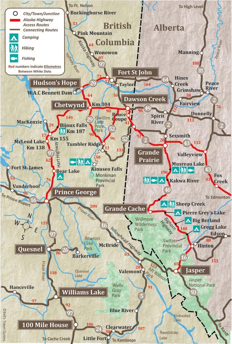
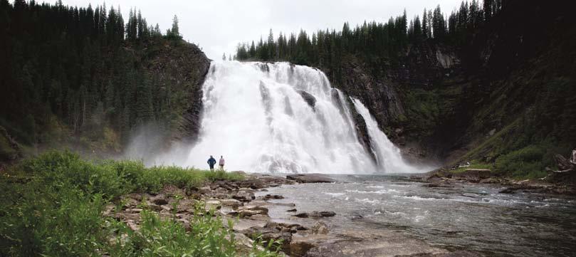
The Spectacular Kinuseo Falls south of Tumbler Ridge
HArt HiGHWAY / HiGHWAY 29 & 52
Advertisement
The Hart Highway, named after former Premier of British Columbia, John Hart, begins in Prince George and winds its way northeast 395 km to Dawson Creek. The Hart Highway accesses the towns of Mackenzie and Chetwynd. Mackenzie is reached by a 29 km side road and was built in 1965 during the construction of the Peace River Dam. Mackenzie Visitor Information Centre is at the Mackenzie road junction with the Hart Hwy. Chetwynd is at km 304 and is home to a fantastic collection of chainsaw carvings and some very friendly people. The highway continues past Chetwynd for 90 km to Dawson Creek and the beginning of the Alaska Highway. The Hart Highway is usually in good condition and most of the grades are moderate, except the Pine Pass, which is quite steep.
Chetwynd is at the junction of Hwy 29 and the Hart Highway. Hwy 29 accesses the town of Tumbler Ridge, 90 km to the south. 46 km south of the junction with the Hart Highway you will find Gwillim Lake Provincial Park with 50 campsites, water, picnic tables and firepits. There is excellent fishing, a boat launch and day use area.
Built as an “instant town” in 1981, Tumbler Ridge was carved out of the wilderness to facilitate coal mining activity in the area. Fascinating geology, an abundance of waterfalls and an amazing discovery of dinosaur trackways all played a part in Tumbler Ridge being designated a UNESCO Global Geopark in 2014.
One of the area’s most famous attractions is Kinuseo Falls in Monkman Provincial Park. The falls are spectacular, and at 70 metres/230 ft. they are taller than Niagara Falls. They are located 60 km south of Tumbler Ridge, 48 km of which is on a gravel forest service road. Monkman Provincial Park has 20 dry campsites and a day-use area, just 3 km from Kinuseo Falls. To continue to Dawson Creek from Tumbler Ridge drive 96 km on Highway 52 North. At the Hart Hwy, turn right (east) and drive 13 km to reach Dawson Creek. Highway 29 also continues north from Chetwynd. It stretches 137 km, passing through Hudson’s Hope and connecting with the Alaska Hwy, north of Ft. St. John. Moberly Provincial Park is 25 km northwest of Chetwynd, has 109 campsites, a picnic area, boat launch and sani-dump. There is a 3.5 km access road to reach the park on the shores of beautiful Moberly Lake. The Hudson’s Hope area saw explorers as far back as the late 18th century, but the modern town really developed in the 1960’s during construction of the Peace River Dam, now known as the W.A.C. Bennett Dam. The Dam, only 24 km west of town, is one of the world’s largest “earth filled” Dams, rising 183 metres/600 ft. The Visitor Centre at the Dam is open from late May to early September and offers tours. From Hudson’s Hope to the Alaska Highway is 73 km and passes Site C, the new mega Dam being built. There are a number of steep climbs and descents along this section, including some 10% grades.


