Frank Lohrberg Katharina Christenn Axel Timpe Ayça Sancar (Eds.)
Al
Guangzhou Tokyo Cotonou St. Petersburg Jos
vegetable
Little
Cairo dairy
Qanat-based
Kuttanad
Home gardens, Hanoi Vlei agriculture, Harare VOC Vegetable Garden Oranjezicht City Farm Philippi Horticultural Area La Huerta de Valencia Bosco di San Francesco Sant’ Erasmo Juckerfarm Knoblauchsland Gut Hebscheid Budé Farm Palmeral
Lisbon Granada Madrid Badalona Rome Milan
Bourges Amiens Bamberg Augsburg Belgrade Mojšová Sofia Erfurt Hamburg
Hamra
Plateau
farming
Akaki valley farming
farming
sa ron farming
Below Sea-Level Farming System
de Orihuela Palmeral de Elche
Montreuil
This book and the preceding Herrenhausen Conference “Urban Agricultural Heritage and the Shaping of Future Cities” in Hanover in 2019 were supported by VolkswagenStiftung.
Birkhäuser Basel
Frank Lohrberg Katharina Christenn Axel Timpe Ayça Sancar (Eds.)
8 Urban Agriculture as Heritage
Frank Lohrberg
Linking Urban Agricultural Heritage to Historical Research and Food Policies
24 Early Modern Urban and Peri-Urban Horticulture in German Territories
Ansgar Schanbacher
32 The City as a Driver of Regional Agriculture: Erfurt and Its Horticultural Heritage
Sibylle Küttner, Frank Lohrberg
40 The Role of Centralized Policy Planning for Bulgarian Urban Agricultural Heritage from the Socialist Period
Dona Pickard
44 Heritage at the Urban Fringe: Allotment Gardening in Europe as Urban Agricultural Heritage
Attila Tóth
50
Russian Dachas: A Popular Urban Agricultural Heritage
Johanna Altendorf, Jay Heydecke, Katharina Christenn, Axel Timpe
Linking Urban Agricultural Heritage to the Concept of Cultural Memory and Practice
66 Belgrade’s Garden Colonies: Where Memory, Nature, and People Meet
Slavica Cepic´, Dragana Corovic´, Jelena Tomic´evic´-Dubljevic´
72 From Marshes to Market Gardens: Hortillonnages d’Amiens and Marais de Bourges
Leandra Brunet, Nicole Laufhütte, Axel Timpe, Katharina Christenn
80 From Orchard to Wetland Park: Guangzhou’s Approach to Transform Urban Agricultural Heritage
Mengyun Chen, Guangsi Lin
88 Urban Agricultural Heritage of Lisbon: From the Past to the Future?
Mariana Sanchez Salvador
98 Urban Agricultural Heritage in Benin: The Role of Traditional Coconut-Cattle Systems in Cotonou
Bossima I. Koura, Eric Boenecke, Frank Lohrberg, Luc H. Dossa
Linking Urban Agricultural Heritage to the Concept of Cultural Landscape
56
Resilient Cities with Urban Agricultural Heritage: Tokyo
Giles B. Sioen, Makoto Yokohari
106 La Vega de Granada: A Cultural Landscape Built Around Irrigation
Anna Kerfers, Ardiana Rahimi, Axel Timpe, Katharina Christenn
112 Hidden Urban Agricultural Heritage at the Manzanares River: Toward an Agroecological Wedge in the Southeast of Madrid City
Nerea Morán, Marian Simón Rojo
120 Protection and Values of the Cultural Heritage of the Campagna Romana between Public Policies and Movements from Below
Anna Lei
126 Urban Gardening as a Practice to Safeguard Historical Agricultural Sites in Can Cabanyes and Torre Codina (Badalona, Catalonia)
Xavier Recasens, Dolors Nieto, Clara Forn, Oscar Alfranca
Introduction
Showcasing and Reflecting Active Heritage Approaches
134 Intangible Agricultural Heritage as a Resource for Sustainable Contemporary Cities
Paola Branduini
142
Bamberg Market Gardeners’ District—A Living Cultural Heritage for Centuries: Solutions for Dealing with Tangible and Intangible Heritage
Diana Büttner
150 Strategies to Reanimate the Urban and Agricultural Heritage of Oasis Settlements
in Oman: The Case of Al Hamra
Alexander Kader
158
Chinampas of Xochimilco: Urban Agriculture from the Ancient Americas Until Today
Laura Camacho Latz, Sophie Laukemper, Katharina Christenn, Axel Timpe
Informal and Local Approaches to Urban Agriculture Heritage
168
Transformation of Everyday Landscapes into Heritage: A Driver for Territorialized Agro-Food Systems in the Peri-Urban Context of Madrid
Rafael Mata Olmo, Carolina Yacamán Ochoa, Esther Sanz Sanz
176 Murs à Pêches de Montreuil: Rediscovering Urban Agricultural Heritage
Ayda Hamid Kargari, Kevin C. Wehnert, Katharina Christenn, Axel Timpe
198 References 211 Image Credits 216 Authors’ Affiliations
217 Editors’ Biographies
182
Reconnecting City and Countryside: Participatory Solutions for Hamburg
Ole Oßenbrink, Birte Mehrkens, Andreas Ulbrich, Cord Petermann
188
Enhancing and Promoting Milan’s Peri-Urban Agricultural Landscape as a Cultural Resource: The Case of MUSA
Andrea L’Erario, Paola Branduini, Raffaella Laviscio, G. Matteo Mai, Lionella Scazzosi, Francesco C. Toso
Appendix
Urban Agriculture as Heritage
Frank Lohrberg
Urban Agriculture Is Thriving …
Since 2010 urban agriculture has turned out to be an important tool in city planning. Addressing global challenges such as rapid urbanization and food security, a lot of initiatives emerged all over the world promoting the production of agrarian goods within the city. Also, the United Nations Food and Agriculture Organization (FAO) is engaging in urban agriculture to establish it as a “recognized urban land use and economic activity, integrated into national and local agricultural development strategies, food and nutrition programs, and urban planning.” In its Growing Greener Cities initiative, the FAO (2010) is funding micro-gardens in numerous cities in developing countries to enhance food security and urban greenery as a double benefit. Most urban agriculture initiatives focus on creating new systems like the FAO micro-gardens. The qualities of inherited and existing systems of agricultural production have not been explored systematically yet. The same is true for media coverage, which is very much interested in urban agriculture but often narrows its reports to high-tech solutions such as vertical farming or edible green facades.
… but a Look Back Is Missing
While focusing on new and cutting-edge forms of urban agriculture, its historic continuity or discontinuity within the city has not been a subject of investigation. With this book we will point out for the first time that urban agriculture is not an invention of the twenty-first century. Its roots are much older, going back to the very first cities that were founded in regions such as Mesopotamia or the Nile River Valley, with their high agricultural productivity. However, agriculture in urban history has been treated as a footnote. Furthermore, the scientific discourse often presents it as an antithesis to the city: while agriculture is associated with rural areas, the city is defined by infrastructure, industries, power, culture or arts—and by overcoming a primary production (Siebel 2015).
8
However, with a closer look one could see that agriculture has been linked to the city throughout history—think, for example, of farming citizens’ towns in medieval Europe or small-scale, agriculture-oriented workers’ housing estates which emerged during the Industrial Revolution. As well as in planning—think of the highly influential Garden City concepts of Ebenezer Howard or Frank Lloyd Wright’s Broadacre City, which both highlighted a crucial role for agriculture in cities of the future (Lohrberg 2001).
Lessons Can Be Learned from History …
Today, being aware of this past is more relevant than ever. Sustainable economies have to turn away from a fossil-based energy supply. This will lead to considerable changes in the metabolism of cities and their agriculture in the long term. Acting at the city-regional scale is becoming more important as shown by the concepts of the circular urban economy, regional food policies, or urban-rural partnerships. In this transition it is helpful to revisit historical examples of urban agriculture, especially if they have survived up to today. How could forms of agriculture in Tokyo, Granada, or other cities of the world persist for centuries? How did they survive the test of time (Koohafkan, Altieri 2011), and what lessons are to be learned from this? What has been the role of agricultural systems in ancient Mexican cities and how should we treat the remnants of this traditional form of production today?
… and Put into Practice by Heritage
Answering these questions will transcend a purely historical interest and approach urban agriculture as heritage. From a heritage perspective we expect a more reflective practice in urban agriculture, an attitude that consid ers it not as a new and ahistorical phenomenon but as one that has shaped cities over millennia and in different forms. By exploring this heritage, we will gain a stock of multiple knowledge and illustrative material on urban agriculture. As will be shown, the notion of heritage will also allow us to highlight specific historical settings and unravel their values—both universal and local—and act toward a sustainable development of cities.
Understanding the Process of Heritagization
This volume is the first undertaking to digest approaches dealing specifically with urban agricultural heritage. There is little academic experience in this field. The current situation is reminiscent of the early 1990s, when urban agriculture was conceptualized (Smit et al. 1996). It took more than two decades for it to turn from a phenomenon experienced as exotic to a globally recog nized instrument for sustainable urban development. To unfold the heritage dimensions of urban agriculture will also afford a long run.
But how about the roadmap for this long run? And what is the starting point represented by the contributions of this volume? To figure out this baseline it is helpful to realize that heritage is a subject of processual construction.
9Introduction
Linking Urban Agricultural Heritage to Historical Research and Food Policies
The City as a Driver of Regional Agriculture: Erfurt and Its Horticultural Heritage
Sibylle Küttner and Frank Lohrberg
The relationship between urban development and agriculture has been a long-neglected topic within historical research. Fortunately, in recent years, this theme has begun to receive greater attention from researchers and academics, thereby highlighting the complex historical interconnec tions between cities, agriculture, and their food resources (for example, Daviron et al. 2019). This essay, focusing on the city of Erfurt and its unique horticultural heritage, aims to provide some additional insights into these topics. The case of Erfurt clearly demonstrates that it has not merely been a passive recipient, nourished by the agricultural produce from the surrounding hinterland. In many places throughout its history, Erfurt has played a proactive role, consciously driving the pace of agricultural development and horticultural activities on a regional scale. It has promoted and commercialized agricultural production through the development of unique trading oppor tunities and also through its administrative and educational systems.
The role of cities as drivers of innovation in agriculture and the highlighting of such connections in greater detail offers considerable potential for gathering new insights. This is also increasingly relevant in the present day, as in recent years, stakeholder groups in many cities have been repositioning themselves and are calling for a radical rethink of our food supply and its functioning. Erfurt shows that municipalities do not have to start from scratch, but can also draw upon traditions, collective prac tices, and experience.
Historical Outline
Erfurt is one of the oldest cities in Germany. By the early Middle Ages, the city had already developed into the political and economic center of the Thuringian Basin, a natural region sheltered between the low mountain ranges of the Thuringian Forest and the Harz Mountains. The region possesses a warm, dry climate and boasts fertile loess soils, making it highly favorable for agriculture. In the first documented reference from AD 742, Erfurt was described as a fortified settlement predominantly of pagan farmers. In 1133, documents specifically mention horticulture within the city for the first time, referring to a special form of agriculture that was scaled up to provision the city directly with fresh fruit and vegetables (Czekalla 2011, 271).
Erfurt developed a special interconnection with regional agriculture between the thirteenth and the seventeenth centuries. This was the period of peak production for Färberwaid (dyer’s woad, Isatis tinctoria), a flowering plant whose leaves can be used for the extraction of glycoside indican, one of the few possibilities during the Middle Ages for obtaining blue dye. Stimulated by a huge demand for blue-dyed textiles, woad was cultivated in more than 300 towns and villages within the Thur ingian Basin and was sold around the region’s urban markets (Müllerott 1991). Due to its considera ble economic power, Erfurt was able to secure the majority of the regional harvest of woad and developed into a European center of woad processing and trade, ahead of other competing towns such as
32
Fig. 1 How alive the memory of woad cultivation is in the Thuringian Basin is shown by the woad mill in the municipality of Ballstädt, Gotha county, which was reconstructed here and erected in 2014. In 1991, 152 original millstones still existed in the region. One of them can still be found in front of the German Horticultural Museum on the grounds of the egapark.

Arnstadt or Gotha. The City Council actively helped in this process, issuing a decree in 1351—which was probably copied from an older document—that required all farmers around Erfurt to sell their woad harvest exclusively through the main Erfurt Market (see Noll-Reinhardt 2017; Selzer 2011, 24ff.). Thus, the city merchants—so-called Waidjunker (woad lords)—received their supply of woad leaves from far and wide and not just from the immediate vicinity. The leaves were first ground up [Fig. 1], formed into balls, and then dried for transport and storage. Despite the accompanying stench, processing and refining these semifinished products took place within the city walls (Selzer 2011, 30). The high profit margins of 25 percent for the dye, which was traded mainly to the economic centers of northern Germany and the Netherlands, apparently made the “stinking rich” woad lords so influential that stinky woad-processing was tolerated within the city center (Müllerott 1991). Large woad store houses in Erfurt’s Old Town still bear witness to this former economic phase [Fig. 2]. The urban wealth acquired through the woad trade certainly also played an important part in the founding of Erfurt University as early as 1392. At the beginning of the seventeenth century, the demand for woad decreased due to
cheap imports of indigo from India. Farmers in the Thuringian Basin therefore had to look for new alternative crops to ensure their continued livelihoods. Although there are no detailed studies on this period of agricultural transformation, it can be assumed that parts of the agricultural production system were re-localized and returned to traditional subsistence farming for local needs. It is also interesting to note, however, that the long-standing interregional character of farming, with its emphasis on specialist commodity production, appears to have originated during the phase of woad cultivation in Erfurt. This later influenced the development of a highly com mercialized and specialist horticulture in following centuries (Herz 2021, 11). In fact, the first resulting commercial market gardens can be traced back to the end of the seventeenth century. Among others, Johann Peter Haage, mentioned for the first time in 1685, founded the Erfurt horticultural dynasty Haage, which still exists today (Schalldach 2011, 76). An important pioneer of Erfurt’s commercial horticulture was the Councilor Christian Reichart (1685–1775). From today’s perspective Reichart might be considered an innovative practitioner, who developed and tested numerous new horticultural methods and equipment. In particular, his method of cultivating the Erfurt speciality, Brunnenkresse (watercress, Nasturtium officinale), which is still practiced today (Fischer et al. 2017) [Figs. 3 a–c]. Reichart used indigenous wild watercress, turned it into a horticultural product, and thus paved the way for

33
Fig. 2 New uses could be found for some of the still existing former Waidspeicher (woad storages). The cultural use as theater, museum, or gallery predominates. The picture shows the Waidspeicher Theater, Domplatz 18.
Historical Research and Food Policies
Fig. 3a Cress cultivation at the Haage company in Dreienbrunnen, ca. 1930. Between the basins are strips for vegetable beds.

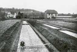

Fig. 3b Harvest on the Haage cress basin fields after modernization, ca. 1961. To increase yields, the strips between the basins were removed.
Fig. 3c Unique horticultural craft: watercress cultivation as developed by Christian Reichart in the mid-eighteenth century
34
17th century 18th century 1890 1980
Wetland Fountain River Canal
1936 2021
Figs. 4a–f Spatial development of cress basins, canals, and water bodies in Dreienbrunnen, seventeenth century until today
Historical Research and Food Policies
35
watercress to be regionally and internationally marketed as an Erfurt delicacy, which was appreciated even in ruling houses. Based on Reichart’s invention, it was undertaken in long, shallow basins with fresh spring water flowing through them, the so-called Kresseklingen (cress basins with flowing water). The alternating parallel layout of basins and Jähnen (strips of land) regulates irrigation and allows the cultivation of various other vegetables. This integrated, multilayered structure proved to be very efficient and high-yielding, so that the former wet lands were gradually drained and transformed into a distinctive horticultural landscape from the eight eenth until the end of the nineteenth century [Fig. 4]
In addition, Reichart’s development of the 18year, without fallow, rotation system was significant. According to this model, ten years of vegetable cultivation were followed by eight years of cultivation of various other crops (Reichart 1754). These innova tions testify to his scientific approach to systematizing and optimizing local cultivation methods. He also laid the foundation for the Erfurt seed-breeding tradition with his flower and vegetable breeding programs—among other things, he acclimatized and bred cauliflower (Reichart 1753). Moreover, Reichart not only practiced but also published textbooks on horticulture, making use of the extensive publishing resources available in Erfurt. The city’s postal net work also offered him the opportunity to exchange scientific information with like-minded experts; within Erfurt itself, in Germany, and beyond. Seeds and cuttings were sent over great distances for this purpose. Reichart’s work not only strengthened Erfurt’s commercial horticulture internally, but also gave it considerable external impact through his publications and far-reaching connections (Pontius et al. 1985, Czekalla and Prass 2011).
Building on Reichart’s fundamental work, Erfurt’s commercial horticulture experienced its heyday in the nineteenth and early twentieth centuries. The Erfurt directory of 1894 lists 119 market gardens (Moritz 2021, 4). A large number of these specialized in the breeding of fruit, vegetables, and flowers. Over time, Reichart’s postal distribution of seeds gradually developed into a profitable worldwide seed-trading business. Seed-breeding techniques benefited from the dry climate of the Thuringian Basin, which allowed the plants to retain and devel op their seeds to full maturity. The seeds harvested in Erfurt were therefore of high quality and high
yield. Fields of flowers and vegetables blossomed and fruited all around Erfurt—an image that was also exploited by the local tourist industry for pro motion of the city. In addition to its existing titles of “Cathedral City” and “Luther City,” Erfurt was given the title of “City of Flowers” at the end of the nineteenth century, a title that has shaped Erfurt’s self-image and is still used today [Fig. 5]
The horticultural tradition was continued after 1945 under Socialist economic policies, which, in the majority of cases, were responsible for the involuntary merger of agricultural and horticultural enterprises into larger production cooperatives Landwirtschaftliche Produktionsgenossenschaften and Gärtnerische Produktionsgenossenschaften (LPG/GPG; agricultural/horticultural production cooperatives). The transformation into LPGs, GPGs and Volkseigene Betriebe (VEB; People’s Own Enterprises) took place through a series of incre mental steps between 1946 and 1979.
With the Volkseigene Gartenbaubetrieb (VEG) Saatzucht Zierpflanzen, founded in 1956, various horticultural cooperatives for fruit and vegetables, and the establishment of research and teaching institutes, Erfurt became an important center for horticulture in the GDR, especially floriculture (Czekalla 2011, 275).
A wide range of species and varieties was pro duced, serving markets within West Germany too.

36
Fig. 5 This picture postcard from around 1910 shows a very typical postcard motif for that time: a city view of Erfurt, embedded in fields of flowers, with a woman with a basket of flowers (a gardener or flower seller) standing to the side in the foreground of the picture.
The Role of Centralized Policy
Planning for Bulgarian Urban Agricultural Heritage from the Socialist Period
Dona Pickard
Contemporary urban agriculture in Bulgaria has been driven by bottom-up citizens’ initiatives since the beginning of the 2010s, and no top-down policies on urban agriculture have been implemented so far. The dominant discourse on urban agriculture views it as a novelty, driven by postmaterialist values for environmental sustainability and social cohesion (Koleva and Pickard 2015). Little attention is paid to the predemocratic history of urban agri culture, probably because it is all too easy to dismiss the practices that resulted from totalitarian rule, to which there are too many obvious objections related to centralized power and the often oppressive regime. On the other hand, many of the urban agriculture demands that citizens have toward policy makers today correspond to policies implemented by the regime before 1989, which included agricul ture in its vision of a modern Socialist city. Undoubtedly, the social dynamic was much different then— urban agriculture policies from the beginning of the 1970s were dictated by the need to ensure a regular supply of fresh food to citizens in urban centers that grew fast and drew human resources from the countryside (Fol et al. 1981, 452–62). Thus policies that fostered practices of urban agriculture were not based on environmental or social values, but regard less of the motives behind them, they indirectly led to such results.
Three goals that urban agriculture activists have today and were enacted during the Socialist regime are presented here. They can give clues as to how they can affect the contemporary urban communities in Bulgaria. This is done on the basis of data gathered
during the research project Urban Agriculture as a Strategy for Improving the Quality of Life of Urban Communities (2016–20, funded by the Bulgarian National Science Fund) and a desktop study of archival documents.
The key demand concerning urban agriculture that civil society has of policymakers today and which has not been met, is to legally recognize urban agriculture as a public priority. What the activists want is a legal act or an article in existing municipal ity bills that defines urban agriculture as an activity with public benefits, hence eligible for public support. Astonishingly, in Socialist Bulgaria such legal acts were introduced as early as 1963. They stated that “every acre of land” (State Gazette [SG] 1963), including the land in the urban peripheries, along rivers and canals, around airfields, and on the grounds of schools and enterprises, needs to be put to full use by people for personal use, contributing to the households’ food self-sufficiency (SG 1963; SG 1978a; SG 1978b; SG 1982; SG 1987).
The land was to be given out to individuals and households by demand and for free, “for eternal use, 1 to 2 decares [1,000–2,000 square meters] per household” (SG 1963). This right of use was to be transferred to their heirs, provided they continued to cultivate it. If any plot of land was not cultivated for two years, the regional institutions were responsible for taking it away from its users. Users had to observe strictly the officially outlined good practices for protecting the land from erosion and pollution; there were also set norms for animal welfare and veterinarian and hygienic standards.
40
Until the end of the 1970s these lands could not be built upon and had to be dedicated only to agricultural activities, which corresponds to the modern demands of urban agriculture activists to protect agricultural land from construction works.
The regulations that were passed from the 1960s to the 1980s made it possible for a large share of urban dwellers to obtain a plot of land for food production in peri-urban areas. As the policies addressed all family holdings, already existing household gardens and micro-farms, which were very common inside many cities (Yoveva and Mishev 2001, 14), were also covered by these new policies, includ ing new norms and standards ensuring that every food producer, no matter how small and whether they produced only for their family, had access to good

quality seeds, breeding animals, and agricultural services.
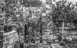
This policy line was built upon until the end of the 1980s and led to the creation of self-organized communities in the newly created allotment areas. In the peripheries of large cities, the state provided land, but the tasks of drilling water wells, getting connected to the electricity network, and building roads and other community facilities were organized by the new plot owners, who often democratically chose managers and treasurers of the community activities. Unlike the family gardens on private land within cities, those new territorial formations developed stronger social cohesion. From the end of the 1970s, when building houses on the plots was allowed and when the land could be bought from the state, these plots gradually lost their food production pri mary role and in the long run, in most cases, turned to residential and recreational areas. Older inter viewees share their observations that the communities they built have now disintegrated as younger generations are not interested in tending the plots and either sell them off or keep them as summer houses without maintaining close connections with the neighbors [Figs. 1a–b].
A second demand that bottom-up initiatives have toward policymakers in Bulgaria today is to ensure not only land, but also materials for agriculture— soil, seeds, tools, etc. especially for socially responsible initiatives such as educational or socially integrative urban gardens. To provide such materials and support, the Socialist regime set in its decrees a responsibility of state agricultural holdings and local institutions to include in their yearly plans ad ditional amounts of seeds, fruit trees, fertilizers and chemicals, animal feed, veterinarian products, as well as the needed advisory and veterinarian ser vices for private gardens and farms. Additionally, to secure the “faster introduction of new technolo gies, highly productive animal breeds and plant hybrids as well as other achievements of the scientific and technological progress in agriculture” (SG 1982), research institutions had to extend their knowledge and services to all holdings, including small family ones. Although this regulation was not specifically targeted at urban agricultural holdings, they made use of it just as much as the rural ones. Special attention was given to creating experimental fields in schools where pupils could learn through experience. With such state support and
41
Figs. 1a–b Private peri-urban vegetable and fruit garden near Sofia in 1976 at the time of constructing a small cottage on the plot
Historical Research and Food Policies
Gardens: Hortillonnages d’Amiens and Marais de Bourges
The Marais de Bourges and the Hortillonnages d’Amiens are two of the last few representatives of market garden swamps in France. They were an important part of life in both cities. For centuries, fruit and vegetables have been grown in the former swamps close to the city for commercial purposes and self-supply. Over the last century, these ecosystems have been threatened by various urban developments. Today the importance of this urban agricultural heritage is recognized and kept alive by various strategies in order to contribute to urban sustainability, resilience, and quality of life.
Location and Characteristics
The city of Amiens is located about 140 kilometers north of Paris, in the Hauts-de-France region. The Hortillonnages are situated east of the city center and extend along both banks of the river Somme. At the end of the twentieth century, they still covered an area of about 300 hectares (Morris 1999, 270) [Fig. 1]. The Marais de Bourges occupy an area of approximately 135 hectares northeast of the historical city center. Bourges is located in the geographical center of France, about 200 kilometers south of Paris, in the Centre-Val de Loire region. The Yèvre River [Fig. 2] divides the Marais into the Marais du haut and the Marais du bas (the Upper and the Lower Swamp), which are separated by a height difference of two meters (L’Association des Maraîchers de Bourges 2009a).
The Hortillonnages were created by the monks of nearby abbeys in the thirteenth century. The former landscape was part of the marshy river valley of the Somme, overflowing its banks and flooding the surrounding areas. The soils were charac terized by peat and high moisture as well as by a high fertility due to large proportions of organic matter and therefore excellently suited as arable land (Musset 2003, 327; Limouzin 1994, 157). The monks reclaimed the land by draining the area and creating islands used as agricultural plots (Conan 1993, 20). The French name Hortillonn nages comes from the Latin radical hortus (garden). The gardeners were and are still referred to as Hortillons (Morris 1999, 270).
The Marais were also founded by monks, but only in the seventeenth century. Before fruit and vegetable cultivation developed, the area was used for fishing and to run mills, and thus was already essential for supplying the urban population with food (Narboux 2010, 15–16). From the begin ning, the gardeners were called Maretiers (L’Associ ation des Maraîchers de Bourges 2009c).
The plots of the Hortillonnages and the Marais were leased to city dwellers for agricultural use. Until then, vegetables were scarce and of poor quality due to transportation from distant production sites and difficulties in preservation. Furthermore, urbanization caused an increasing demand. The availability of large amounts of water made the marshes of Amiens and Bourges an ideal location for cultivation (Morris 1999, 270; Narboux 2010, 15–16; Fleury 1998).
72 From Marshes to Market
Leandra Brunet, Nicole Laufhütte, Axel Timpe, and Katharina Christenn
SaintLeu
Quai Bélu
Cathédrale Notre Dame d‘Amiens
Somme
Fig. 1 The Hortillonnages d’Amiens, the gardeners’ quarter Saint Leu, and the floating market on Quai Bélu in a figure-ground plan of the city
Langis
Port
0 200 400 600 1000 m N Marais du bas
Port Port
Marais du haut
Cathédrale de Bourges 0 200 400 600 1000 m N
Fig. 2 The Marais de Bourges, its rivers, and its ports in a figure-ground plan of the city
The Concept of Cultural Memory and Practice
73
Yèvre Yèvrette
Voiselle GrandCanalde Dessèchement
Urban Agricultural Heritage of Lisbon: From the Past to the Future?
Cities face pressing challenges regarding food security and sustainable development, aggravated by fast urbanization and globalized, industrial food systems. Urban agriculture has been pointed to as an innovative approach to overcome the current urbanrural divide (FAO 2019) and achieve urban sustainability. Yet agriculture has always been part of cities, and its heritage stretches far beyond land use. Its recognition and promotion could mitigate those challenges, but also revive sites, socioeconomic functions, and cultural connections, turning urban agricultural heritage into a valuable tool for sustainable urban planning.
Lisbon’s Agricultural Past
Lisbon, Portugal’s capital city, has a long tradition of urban agriculture, due to its natural topography and orography. Located by the Tagus River, on the Atlantic shore, the region possesses basaltic soils suited to grain cultivation, while the Miocene soils were suited to vineyards, olive groves, pastures, and vegetable gardens (Gaspar 1994, 83). Thus, since prehistoric times, and then with the Romans and Moors, the valleys and slopes have long been cultivated.
The medieval land uses showcased an organiza tion similar to von Thünen’s model: a ring of fruit and vegetable production was located around the city center (on average 1.8 kilometers from it), followed by a ring of vineyards with olive trees (on average 5 kilometers) and a third for grain cultivation and livestock (Trindade and Gaspar 1973, 5–7).
Historically, the fertile outskirts stretched for 30 kilometers around the city. The Saloia Region spreads to the north and west, while the Outra Banda is located across the river [Fig. 1]. Despite subregional differences, both have supplied abundant vegetables, fruits, grain, dairy cattle, and sheep [Fig. 2]. The Mediterranean trinity—bread, wine, and olive oil—held a particular economic role (Brito 1976, 168). Although the Saloia Region yielded an impressive 360,000 réis per hectare in 1887, even higher yields were attained within the city, reaching 500,000 réis (Pereira 1971, 181).
For centuries, numerous hortas (vegetable gardens) intertwined with Lisbon’s built fabric [Figs. 3 and 10, p. 95], especially in the extremely fertile valleys of Valverde and Arroios (toward the city center), of Alcântara in the west [Fig. 4], and of Chelas in the east. Also, until the mid-twentieth century, the northern highlands of Campo Grande [Figs. 5 and 6] displayed an especially high concentra tion of hortas in the city, as well as Campo Pequeno and Campolide (campo meaning “field”). Tradition ally, hortas were small (less than one hectare) and highly productive, with up to five or six crops a year (180). In the early twentieth century, at least 40 percent of the municipal territory was still cultivat ed (Marat-Mendes, Bento d’Almeida and Mourão 2015, 280), with hortas, vineyards, and olive groves predominating in the east, and ploughed lands for grain and potatoes in the west (Niza et al. 2014, 8). This productive character is further attested by the cartographic survey of 1904–11 [Fig. 7], where 529 quintas (farms) and 52 casais (smaller agricultural
88
Mariana Sanchez Salvador
Marat-Mendes, Bento d’Almeida and Mourão (2015) which enabled the mapping of cultivated areas. The identification of hortas was clear [Fig. 8] amount ing to 751 hectares (8.56 percent of the municipal area)—enough to feed a tenth of its population—as well as of vineyards, occupying 606 hectares (6.91 percent). The built area remained at 530 hec tares . Less conclusively, according to the provided legend, olive groves could reach 22.7 percent of the municipal area, and ploughed lands up to 28.5 percent, summing up a considerable cultivated area. Lisbon and its region were one of the greatest productive areas in the country.
Urban agriculture was thus an important activity, as an extensive land use with constant presence over time, providing livelihoods, income (high yields and exports), and intensive labor, particularly re quired by hortas and vineyards, and one reason why they were located close to the houses. Food pro duction is embedded in the city’s memory, evident in many place names—streets, alleys, and entire neighborhoods, such as Laranjeiras (orange trees) or Olivais (olive groves) [Fig. 9]—and even Lisboners’
was a popular Sunday activity in Lisbon, especially for the lower classes, a practice known across Portugal and that became part of the city’s identity. Plus, the hortas’ beauty and fertility had been praised by writers and travelers for centuries. Lisbon’s urban agricultural heritage thus consists of a material dimension related to land use, and an immaterial one, connected to daily labor, weekly leisure, every day comings and goings, literature, and long history, becoming part of its cultural character.
However, despite its exceptional productivity, the capital, which hosts the country’s largest population, has never been self-sufficient. Each year, it produced 172,735 kilograms of potatoes, which represented merely 0.95 percent of its consumption; 228,570 kilograms of fruits (1.59 percent of consumption); and 1,033,565 kilograms of wine (2.20 percent of con sumption), among others (Marat-Mendes et al. 2014, 8). Thus, Lisbon has always imported food from the rest of Portugal and even overseas using both land routes and the river.
As demographic and economic transitions occurred, the perception of urban agriculture declined. Across

The Concept of Cultural Memory and Practice
89
Fig. 1 The land surrounding Lisbon, 1856–66. Map showing the outskirts of Lisbon, spreading to the Saloia Region in the north (yellow outline), and Outra Banda in the south (red outline)
Rice fields
Mixed crops
Vegetable gardens
Salt basins Olive groves
Pine woods
Ploughed lands
Vineyards Aquariums
Fig. 2
Crops in and around Lisbon, in 1900
the city, many agricultural sites were progressively lost to systematic urbanization and to an ideal of modernity, where urban hygienist conceptions prevailed. Agriculture was generally seen as a backward, rustic, and dirty activity by early twentieth-century society, and modernizing the city became a priority for the city council (Barata 2010; Henriques da Silva 1994). The cultivated areas of quintas (hortas, orchards, fields) were built over, while buildings and ornamental gardens were kept (Ribeiro 1992). From the mid-twentieth century on, and particularly since the 1970s, hortas were found mainly among illegal housing neighborhoods (CML 2015, 45).
Lisbon’s Agricultural Present
Recently, urban agriculture has (re)gained a positive connotation within urban planning. The Municipal Master Plan, Lisbon’s main planning instrument (CML 2012), sets the goal for a “multifunctional green infrastructure,” where integrating urban agriculture
is taken as a possible strategy, among others. For this purpose, the Plan thus classifies areas of “green and productive spaces” (94–95).

90
In an interview, Rita Folgosa (2020), coordinator of the municipal Working Group for the Development and Promotion of Urban Agriculture in Lisbon, stated that urban agriculture is integrated into green spaces for environmental and aesthetic purposes to attract people and increase biodiversity, besides all the recognized benefits of urban agriculture, such as social cohesion, migrant integration, and food resources for families and individuals in need. Therefore, a number of municipal horticultural parks were created, where farmers pay low rents for plots equipped with paths, fences, sheds, com posters, and water supply. The city council commits to the structures’ maintenance, monitoring, and farmers’ training, while farmers must cultivate the soil, practice organic agriculture, keep hygienic standards, ensure that plots look aesthetically pleasant, and restrain from building constructions unrelated to agriculture (CML 2018). Plus, the parks carry economic benefits, since the 0
2 4 6 10 km N
Trees
The Concept of Cultural Memory and Practice

95
Fig. 10 Horta in Lisbon, ca. 1900. Vegetable gardens existed around and within the built fabric, being part of the city’s everyday life and landscape.
Linking Urban Agricultural Heritage to the Concept of Cultural Landscape
Foreword
La Vega de Granada: A Cultural Landscape Built Around Irrigation
The city of Granada is best known for its medieval monuments. Architecture such as the Alhambra bears witness to the rich history of the former Nasrid dominion. But outside the gates of Granada extends a landscape that is just as complex and historically significant: For centu ries, the Vega de Granada (floodplain of Granada) has been a continuously anthropized agrarian space, a breadbasket for the city and its surround ing villages. It is one of three main Andalusian basins. Surrounded by calcareous mountains in the shape of a horseshoe [Fig. 1], it opens up to the west through the narrow course of the river Genil (Zurita Povedano 2015, 166). The climate in this area is dry and continental, since the surrounding mountains serve as a barrier to humid Atlantic winds and Mediterranean breezes. Therefore, there is very little rainfall throughout the year, concentrated mainly in the winter season (24–33).
These conditions are difficult for farming and require optimal use of the available water resourc es. Prosperous agriculture is made possible in the Vega by a complex irrigation system, which covers approximately 15,500 hectares (Castillo Ruiz 2010, 21). This system was developed over centuries to ensure a widespread and fair distribution of water in the plain. Its preservation depends on a rich cultural knowledge that has been passed down over generations and is still in use today. However, urban development and vanishing cultural practices threaten the existence of the Vega’s urban agricultural heritage.
Reshaping the Vega for Agriculture
Agriculture in the Vega dates back to the Roman Empire, when it consisted mainly of the “Mediterranean triad”: olive trees, grapevines, and wheat— plants suited for dry soils and hot summers. Due to their cycles, they were harvested either in spring or autumn, while summer was a period of agricultural inactivity (Trillo San José, 2005, 168). This changed with the Muslim conquest in the eighth century, when tropical and subtropical plants such as aubergine, cumin, and mulberry were introduced to the Iberian Peninsula [Fig. 2]. In order to grow them, a constant water supply is needed. The develop ment of an extensive irrigation system allowed higher yields per hectare and an extension of the growing season into summer. One of the oldest documents explaining the irrigation system dates back to 1219 (Zurita Povedano 2015, 142). It shows how the areas around Granada were divided between family clans, with alquerías (a small group of dwellings) in their center, which later grew into villages (132). However, water canals not only supplied the agricultural plots but also the city of Granada. For this purpose, water from the Genil was diverted and carried toward the city by a canal (151). Due to the combined use by the rural and urban population, a clear organization in the distribution of water was essential to avoid conflicts. During the day, water was used for the fields; at night it filled up communal water reser voirs in the city (Trillo San José, 2005, 177). The distribution followed Muslim prayer times, dividing
106
Anna Kerfers, Ardiana Rahimi, Axel Timpe, and Katharina Christenn
the day into five time slots—irrigation and daily life were closely linked (178).
The Muslim kingdom resisted the Castilian forces for about 300 years but eventually, at the end of the fifteenth century, the Christians con quered Granada. With the expulsion of the Muslim population, agricultural activity decreased and changed. While the cultivation of certain crops— for example mulberry—disappeared altogether, the new Christian inhabitants imported methods like crop rotation and adapted them to the existing irrigation system. Wheat, grapevines, beans, and later corn became the main products grown in the Vega [Fig. 2].
The Irrigation Network and Its Hierarchy
the rivers Genil, Dílar, and Monachil. Together with smaller tributaries, they are the natural water suppliers of the plain [ Fig. 3]. Throughout the Vega, the alquerías were turned into official irrigation communities, which branch off water from a riverbed or spring and conduct the water to pagos (“payments,” meaning subareas of an irrigation community). An irrigation network is composed of the acequias (canals) for water transport and volumedividing objects like gates, loops, or dividers. The acequias form a hierarchy [Fig. 3]: The entire community depends on the acequia madre (mother canal). It feeds the smaller acequias secondarios (secondary canals) which then branch off into tertiarias (tertiary canals). As the water advances, the canals decrease in category and size, finally turning into simple ditches. While some ditches end on a plot, others return surplus water to the river or feed the next irrigation community down stream (Junta de Andalucia 2017, 91). Farmers use simple blocking mechanisms to direct the water Cubillas Genil
The Concept of Cultural Landscape
Dílar
107
Fig. 1 Map of the Vega de Granada with its topography and urban development between 1955 and 2015
While inhabitants and farming techniques changed, the irrigation system has hardly been altered because of its efficiency. Its backbone is formed by Urban area 1955 Urban area 2015 0 1 2 3 5 km N
from the ditches onto plots and over a relief of ridges and slopes. Depending on water availability, ground inclination, and soil, the field is modeled in certain ways, directing water faster or slower over its surface [Fig. 4] (Gimeno García et al. 2006, 5).
How to Share and Distribute Water
The organization of the water supply is essential for the functioning of the Vega and depends on elaborate social arrangements, from the communal level down to individual farmers. In most cases a volumetric and a chronological division are combined [Fig. 5]. The volumetric division is carried out through channels, controlled by their width and depth (García Leal 2014, 10). To ensure that the water volumes comply with the established regulations, the acequieros (farmers chosen to be in charge of distributing and dividing water accord ing to customs) regularly check the water level in the canals (11). The chronological division is con-
ducted by water gates, which are opened or closed at certain times. The complex space-time organi zation in the distribution allows for an efficient and precise use of water, but any alteration at one point of the grid can affect the whole unit.
An example of such a complex system is the river Dílar and the six villages that draw their water from it [Fig. 6]. There, the arrangements for water supply between the villages have not changed for centu ries, with records dating back to the 1570s (8). Metal frames with identical proportions divide the river water into six portions, which are then distributed. Consequently, there are villages whose acequia madre is one metal frame wide, and villages with a higher water demand whose acequia madre is two frames wide. In addition to this volumetric split, there is a distinction between day and night usage [Fig. 7, right side]. While some villages draw water con tinuously, the village Las Gabias draws its water only at night, using acequias from three neighboring villages [Fig. 7, left side] (13). In this process, water is led to a watermill which, in addition to its grind ing operation, also functions as a water distributor
Dam Barcinas of river Cubillas
Perfection of irrigation system, division of Genil into: Gorda canal, Arabuleila canal, Tarramonta canal, Alta canal etc.
Drainage of swamp Soto de Roma in Fuente Vaqueros
Creation of Albolote and Cacin irrigation channels: Cubillas and Los Bermejales reservoirs
Fig. 2 Timeline of main irrigation developments, agricultural products, and cultural contexts in the Vega de Granada from 300 BCE
108
Sugarbeet TobaccoGrapes Mulberry Fruit and vegetables Hemp,
Olives PoplarPotato Wheat Wheat VIII 1924XVIII BCE XX 1970XVIIIXVIIXVI Today1950XIX MonoculturePolyculture Polyculture Sugarbeet crisis Agricultural crisis Flax crisis
Industrial
flax, linen, later corn
Roman Empire Muslim caliphate Catholic reign
Revolution
Strategies to Reanimate the Urban and Agricultural Heritage of Oasis Settlements in
Oman: The Case of Al Hamra
For hundreds of years in Oman, cities and agriculture were in a symbiotic relationship, its inhabitants sustained by a sophisticated food cultivation system irrigated by a refined network of water channels called falaj (plural form, aflaj) [Fig. 1]. Settlements were built using local construction materials and techniques. However, the advent of the oil industry in the 1970s saw the disruption of this symbiotic coexistence of agricultural and urban environments. Rapid population growth and unsustainable urban development in previously uninhabited spaces have led to what we now call urban sprawl. Even though the falaj irrigation systems have been registered as a UNESCO World Heritage Site since 2006, the historical urban and agricultural spaces of nearly all of the centuries-old oasis settlements in Oman are endangered and in severe decay.
Al Hamra
Perched on the lower slopes of the Al Hajar moun tain ranges, the 400-year-old town of Al Hamra is a former agricultural center containing mud-brick mansions of two to three stories. Local materials, mainly earth, stone, and wood from date palms, form the built structures of the compact agglomeration of houses, while the course of the aflaj determined the positioning of every feature of the settlement, including the grain and vegetable fields, the palm gardens in the west, and the layout of the plots of land (Gangler 2003) [Fig. 2]. The scarce water had been harnessed by farmers for hundreds of years
by canalizing surface runoff, tapping springs, or filtering subsoil water. The water of Al Hamra’s falaj system originates from the nearby Wadi Ghul and the Jebel Shams mountain range. It arrives at the westernmost part of the agricultural plantation area, where it splits to irrigate the agricultural area as well as the settlement. Once made accessible, the water is channeled through small irrigation canals to the fields, operating on gravitational flow, without external energy inputs (Luedeling 2007). Aligned with such a viable system of water flow is a stratification of cultivation in three tiers to make effective use of the limited water supply: the lowest tier includes vegetables and grain such as wheat and sugarcane; the middle tier has small fruit trees such as banana, mango, pomegranate, citrus, apricot, and peach; while the uppermost tier consists of a roof of date palm crowns, the leaves of which provide shade for the tiers below [Fig. 3]
In a setting like Oman, where water is scarce, the formation of the falaj system to channel groundwater from sources like wells and wadis was a gamechanger. A strong interdependence was established between available water, agricultural plots, crop cultivation, and the inhabitants. The amount of available water determined the quantity of food that could be produced and thus also determined the size of the settlements and so the number of inhabitants who could be supported. Apart from nourishing individual families and trading the surplus in souqs (markets), harvests were also used to feed livestock. The need for imported food was minimal. Thus, like other traditional centuries-old
150
Alexander Kader
Reflecting Active Heritage Approaches

151
Fig. 1 Refined falaj system operating on gravitational flow to irrigate agricultural fields


152
Fig. 2 Compact agglomeration of houses representing the vernacular architectural heritage of Al Hamra with the agricultural land in the background
Fig. 3 Three-tiered agricultural system characteristic of Al Hamra, irrigated by the water from the falaj system
mountain settlements in Oman, Al Hamra devel oped autonomously and flourished with its sophisti cated agroecosystem.
Strong social structures were reinforced for the construction and maintenance of the aflaj systems, with sets of rules, roles, and institutions relying on the bidirectional interdependence between com munity and agriculture. The importance of the aflaj systems to communities is also reflected in the numerous watchtowers built along these waterways to guard them. The inhabitants of the settlements formed social structures that regulated and built houses, urban structures, and agricultural systems (Nagieb et al. 2004). The fair and effective management and sharing of water in villages and towns were—and remain to this day in some cases— underpinned by mutual dependence and communal values, and guided by astronomical observation (Chakraborty 2019). Fig. 4 illustrates this interrelationship between key players of the closed system within the settlement.
With the advent of the oil industry in Oman dur ing the 1970s, the interdependent relationship be tween falaj, agriculture, and built structures was de stroyed. Prosperity led to rapid population growth. While old centers and plantations were abandoned
in large parts, resulting in historical buildings falling to ruins, newly generated income from the discovery of oil provided families with the means to build and settle in larger houses outside the old towns, spreading into the surrounding barren lands and previously uninhabited spaces [Figs. 5 and 6]. Unsustainable construction grew rapidly.
As a result, significant vernacular and agricultural heritage are in danger of dying out. Numerous cities in Oman testify to this unfortunate course of development. Inhabitants’ sustenance shifted from locally produced agriculture and livestock to less healthy, cheaper, and more readily available supermarket food, which is mainly imported.
These developments evoked unprecedented changes to the agricultural systems of the oases, and the implications of these changes altered the settlements from a set of autonomous systems into one that is linear, unsustainable, and greatly reliant on external income and imported food. The complex social structures that maintained and regulated the aflaj systems have almost entirely dissolved in most settlements, leading to only a very few active aflaj side branches being maintained by individual families for their agricultural lands. As a result, there is a significant reduction in the cultivation
Closed system within settlement
channeled to settlements by irrigates
Social structures
Rainwater Houses, urban structures
“Falaj” water distribution
strong community bonds
Agriculture Food
create regulate build nourishes feeds
establishrefinedsystemof
implementa nourishes
Inhabitants
very limited availability plots owned and cultivated by families fruit, grain, and vegetables e.g. goats, sheep, chickens
supports cultivationof
Livestock
only small amount of food and other goods
imported
Fig. 4 Traditional, centuries-old mountain oases of Oman
Reflecting Active Heritage Approaches
153
Murs à Pêches de Montreuil: Rediscovering Urban Agricultural Heritage

The Murs à Pêches (peach walls) are located in the city of Montreuil, a municipality within the first ring of the banlieue parisienne east of Paris. Starting in the middle of the eighteenth century, they were a highly scientific, spatially unique cultivation environment for peach trees and other fruit plants [Fig. 1] Today they are spread over an area of roughly 38 hectares, measuring a wall length of approximately 17 kilometers. Contrary interests in the site led to a complex social framework resulting in slowmoving preservation actions and thus the ongoing destruction of the remaining walls by weather and aging (Maison des Murs à Pêches 2016, 2, 5).
History of the Murs à Pêches
In the late seventeenth century, Réné-Claude Girardot (c. 1734), a musketeer who served under Louis XIV, started developing a special interest in arboriculture (Johanneau 1825, 3–5). On his property in Bagnolet, he planted peach trees alongside head-height walls that provided shelter against the weather and reflected the sun [Fig. 2]. This allowed the Mediter ranean fruits to grow in a temperate climate. Selling his peaches, he earned 30,000 francs per annum (Johanneau 1825, 4). By comparison, a day laborer around 1750 earned a franc a day; meanwhile, a kilogram of wheat was worth nearly five francs (see Fourastié 1986, a; McCuscer 1974, 360, table 3).
Girardot taught his technique to the villagers of Montreuil (De Salaberry 1838, 401–3) and as their yields grew, the Murs à Pêches increasingly attracted
more farmers. Internal competition fostered innovation and resulted in the development of new, more efficient cultivation techniques. Until the start of industrialization during the 1870s, peaches from Montreuil were unique around Paris. The Murs à Pêches measured about 300 hectares with more than 600 kilometers of walls yielding up to 17,000,000 fruits annually (De Decker 2015). When railway transport was estab lished, it became possible to import cheaper, less labor-intensive peaches from southern France, forcing the farmers of Montreuil to focus on fruits more typical for their climate, such as pears and apples (Deville and Brondeau 2017, 112).
Reacting to the international competition, they united and founded the Société régionale d’horticulture de Montreuil (Regional Horticultural Society of Montreuil) in 1878, hoping to achieve higher
176
Ayda Hamid Kargari, Kevin C. Wehnert, Katharina Christenn, and Axel Timpe
Fig. 1 Peach wall compartments (stamp in use from 1907 to 1922)
Humidity regulator
• weather adaptive
• ambient humidity storage
• absorption of groundwater
Humidity regulator
• weather adaptive
• ambient humidity storage
• absorption of groundwater
Thermal activation (gypsum, earth, stone)
• up to 8–12 °C warmer
• nighttime heat storage
Thermal activation (gypsum, earth, stone)
• up to 8–12 °C warmer
• nighttime heat storage
Light reflector (white plaster coating)
• 360° solar radiation
Light reflector (white plaster coating)
Espaliering of fruit trees (plastered coating)
• support for nailing and plant
Espaliering of fruit trees (plastered coating)
Wind breaker (wall + chapéron or cap)
• shelter from chilling air
• physical protection
• 360° solar radiation +
Wind breaker (wall + chapéron or cap)
• shelter from chilling air
• physical protection
returns by branding their fruits as high quality and using merchandising (such as vine-leaf packaging). These attempts failed, so that farmers were ruined by the cheaper competitors and started to leave the Murs à Pêches (Freidberg 2009, 148–54).
Until the period of deindustrialization starting in 1980, great parts of the walls were demolished, mainly to develop industrial areas. Postindustrial transformation in recent years has given way to new ideas to revive interest in the site (Deville and Brondeau 2017, 109–29).
Spatial Structure and Construction
A detailed map from 1773 allows us to analyze the Murs à Pêches spatial structure [Fig. 4]: Each garden compartment is usually bound by two short and two long walls. They are either oriented in a highly radiation intensive northwest direction or a less radiation-intensive northeast direction. Both provide two sunlit and two shaded wall surfaces (Fintelmann 1849, 307). The center of these compartments is planted with smaller plants such as berries or flowers. Hence, each compartment offers three different climate zones, allowing growth of a variety of plant species. The walls consist of small stones (flint, siliceous limestone), earth and gypsum found locally, and a plastered gypsum-charcoal coating [Fig. 5] (Maison des Murs à Pêches 2016, 4).
Cultivation Techniques
• support for nailing and plant
• easy reversibility of old nails
• easy reversibility of old nails Property partition + space optimization
• cooperative maintenance (multiple users per wall)
• walls = fruit trees = profit
Property partition + space optimization
• cooperative maintenance (multiple users per wall)
• walls = fruit trees = profit
+
The Murs à Pêches area features a mixture of harder and softer soil. Soil conditions indicated whether to choose an almond or a plum tree for grafting a peach tree on top so that peaches could be cultivated in all soils (Eßlinger 1767, 100–5; Fintelmann 1849, 307–8).
The most common cultivation method of the eighteenth century focused on “quantitative cultivation” [Fig. 6]: As many trees as possible were planted close to one another, gaining a maximum count of fruits. The alternation of large, older trees covering the upper wall and small, younger trees covering the low er wall led to a “tree-continuum.” Old trees were cut down to make way for the young ones, while saplings were planted in between the trees again. This way, the Murs à Pêches were always covered in the leaves of three generations of trees (Eßlinger 1767, 20–28).
Starting in the 1820s two qualitative cultivation methods evolved, using just a small count of trees: The L’arbre à l’etoile (star-shaped tree) and the L’arbre Baucer (Baucer tree), which was invented by a farmer named Mr. Baucer [Fig. 6].
Only new shoots produce fruits, so those were attached to the walls, while old shoots were cut. The juice pressure—another key factor—was manipu lated by removing and bending parts of the tree in a symmetrical way, leading to stronger, more fruitful branches (Fintelmann 1849, 268–306).
Informal and Local Approaches
177
Fig. 2 Peach wall functions
As the wall’s heating effect was essential to achieve a large output of fruits, trees were grown broad and flat in order to widely cover the wall surface. This was performed by wrapping their branches with small pieces of cloth that were nailed into the plaster with flat, sharp iron nails.
The work in the Murs à Pêches was shared in the family: The men usually cared for the plants and the walls. The women harvested the fruits and took them to nearby markets to sell them [Fig. 3] (Mozard 1814, 84–91, 138–43). During the winter, families prepared cloth pieces for wrapping branches the next year. In the 1870s they also applied small paper bags—often made from old newspaper—to protect the fruits against the snout moth. They were removed two to three weeks before harvest,

allowing the fruits to finish ripening in the sun. This resulted in bigger, juicier and more colorful peaches. By carving the bags with pictures or writing, it was possible to stencil the fruits with light, making them stand out on the market (Freidberg 2009, 148–52).
Heritage Specifics: Values and Potentials
The history and cultivation techniques of the Murs à Pêches demonstrate how exotic fruit can be cultivated in adverse climatic conditions to serve the urban market. The Murs à Pêches have seen a long period of neglect. The site was cut into two by the feeder road of the A186 highway. Former orchards were used for the construction of facto ries, and the remaining wall compartments have been occupied by travelers and illegal waste dumps. But today the site is regaining interest again. Its initial purpose of food production and the need of the densely urbanized Paris region for improved green infrastructure are the most important inspira tions for a transformation that keeps the characteristic values of the site alive.
The Murs à Pêches are located within a dense and heterogeneous urban fabric [Fig. 7] and can be reactivated to serve environmental as well as social goals for and with the local people. After the site’s importance had been rediscovered by citizen groups in the late 1990s, 8.5 hectares were protected in

analysis of the Murs à Pêches (map, 1773; analysis, 2021)
Spatial
Access routes Fruitwall s Otherareas Morningsun Noonday sun Property lines Fruit walls Buildings Public street Residenc1 2 3 e Neighbor Storage building (presumed) 3 1 2
Fig.
3 Farmers harvesting peaches, 1907
Copy editing
Keonaona Peterson
Project management
Alexander Felix, Nora Kempkens
Production
Anja Häring, Amelie Solbrig
Graphics
Katja Gadziak, Katharina Christenn, Axel Timpe, Dennis Lurtz
Layout, cover design, and typesetting
Studio Pandan (Pia Christmann, Ann Richter, Vreni Knödler), Berlin
Paper
Vivus 100, 120 g/m²
Lithography Repromayer GmbH, Reutlingen
Printing
Grafisches Centrum Cuno GmbH & Co. KG, Calbe
Library of Congress Control Number 2022938984
Bibliographic information published by the German National Library The German National Library lists this publication in the Deutsche Nationalbibliografie; detailed bibliographic data are available on the Internet at http://dnb.dnb.de.
ISBN 978-3-0356-2251-5 e-ISBN (PDF) 978-3-0356-2252-2
© 2023 Birkhäuser Verlag GmbH, Basel P.O. Box 44, 4009 Basel, Switzerland
Part of Walter de Gruyter GmbH, Berlin/Boston 9 8 7 6 5 4 3 2 1
This work is subject to copyright. All rights are reserved, whether the whole or part of the material is concerned, specifically the rights of translation, reprinting, re-use of illustrations, recitation, broadcasting, repro duction on microfilms or in other ways, and storage in databases. For any kind of use, permission of the copyright owner must be obtained.
Printed on 100% recycled paper, certified with the German BLUE ANGEL eco-label.
Imprint
www.birkhauser.com
