8 minute read
The disappearing rivers of Poznań
0.6˚C
0.4˚C
Advertisement
0.2˚C
0˚C
-0.2˚C
-0.4˚C
-0.6˚C
1860 1870 1880 1890 1900 1910 1920 1930 1940 1950 1960 1970 1980 1990 2000
Change in global temperature in 1850-2010,source: Climatic Research Unit (University of East Anglia)
climate zones. The area of each zone was determined on the basis of vegetation, which is a kind of a summary of the climate conditions in a given place. Although warm air contains more water, global warming does not cause rise in precipitation in all places. Observation carried out at the beginning of the 20th century indicates that precipitation increased in the eastern parts of both Americas, northern Europe and northern and central Asia. On the other hand, its decrease was noted in the Sahara, the Mediterranean Sea, in southern Africa and in southern Asia. In Poland we can observe a slight rise in precipitation, which is accompanied by the rise in temperature.
Are these changes turning the Wielkopolska region into a grassland?
Steppe formation is a process in which forest flora begins to be replaced with grassland flora. It is caused mainly by a decrease in precipitation. When it comes to Wielkopolska, the amount of precipitation is not falling. In fact, it is even slightly rising. Therefore, we could say that the water balance in the landscape of our region is becoming more and more ‘overstretched’, as the rising temperature is leading to ‘the landscape drying out’. The functioning of the forest ecosystems is bound to become more difficult in these new climate conditions and the species of trees comprising forests are bound to change. However, we should not expect a dramatic change and forests turning into grasslands on a large scale anytime soon.
Prof. Bogdan H. Chojnicki – employee of the Laboratory of Bioclimatology at the Poznań University of Life Sciences. He is the author of numerous publications and popular science articles on the subject of the influence of climate conditions on the functioning of ecosystems, water balance, thermal balance and the exchange of the greenhouse gases between the ecosystems and the atmosphere.
The disappearing
rivers of Poznań Prof. Renata Graf, Prof. Dariusz Wrzesiński
Taking a stroll around Poznań, we rarely think about the way it looked like in the past when the natural environment was unspoiled. We often pass by parks and green areas, look at the Warta River and other smaller rivers flowing through the city but we do not think about their past. When we think about the city’s history we often focus on its cultural heritage, including historical buildings and sites we admire such as the most famous and the oldest ones located on the Cathedral Island and in the Old Market Square. However, we tend to forget that this heritage is the result of the interaction between the people and their surrounding throughout the centuries.
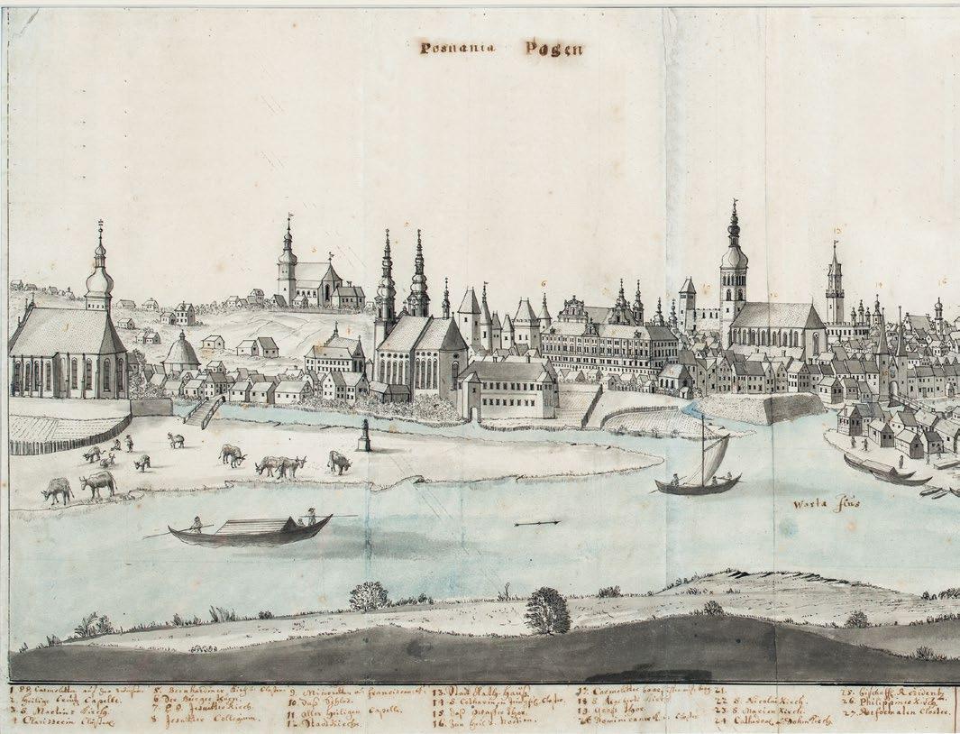
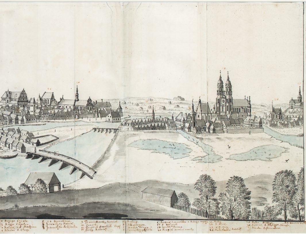
The history of Poznań has been inextricably connected to the Warta River and its tributaries. Over the centuries, their role in the life of the city has changed from the defensive to the economic – connected to travelling, sailing, municipal services and industry as well as fire protection. The Warta and its tributaries were also travelling obstacles which impeded the development of the city. Adapting the river system to the needs of the city affected the living conditions of its inhabitants. In the past, the society’s awareness of the potential of rivers was not as strong as it is today, which most often led to some negative changes in the water systems. Transformation of the river system, which took place in the past and is still happening, results from both climate change and the intensity of economic activity. Human (or the so-called anthropogenic) impact varied over the centuries. However, it has been taking place continuingly since the establishment of the Poznań settlement on the right bank of the Warta River in the 10th century. It has included the deforestation of the area, draining wetlands, putting up new buildings, regulating the river flow, building traffic routes, dykes, bridges and facilities such as water mills, developing infrastructure providing water for drinking and for the economy, introducing flood control solutions. Thanks to the archival resources and the old cartographic documentation, we know that the city’s present-day river system differs from the one in the early Middle Ages. There is no trace of the Warta’s old riverbeds, distributaries and its numerous tributaries in the contemporary urban landscape. Human action led both to the changes in the hydrographic network and to lowering the level of the shallow groundwater. These phenomena intensified in Poznań from the 15th century and their progression was particularly rapid from the end of the 18th and the beginning of the 19th century. Watercourses which were part of the water system in the 19th century, including the Struga Karmelicka (the Kamionka River), the so-called Rotten Warta, the Struga Rybacka and the Obrzyca River, were closed down.
Today, the city is the result of the variability of the process of development and anthropogenic changes in the landscape which began to be introduced on a large scale at the beginning of the 20th
century, when the city gained the title of ‘an open city’, and became particularly intensive in the last few decades. Together with the advancing process of urbanisation, Poznań’s topography has also changed and the city turned its back to the Warta River and moved away from it. The increase of the built-up and tight-fitted area as well as the hydraulic works on the watercourses (including covering them and integrating them into the sewage system as well as shortening and moving the riverbeds) contributed to the changes in the hydrographic network.
Over the last sixty years nearly 80 kilometres of watercourses with exposed river beds have disappeared, the length of the covered watercourses increased by about 27 kilometres, whereas the length of the wastewater collectors increased by 55 kilometres. In the 1960s the old river bed of the Warta River was filled in order to lower the risk of flooding in Poznań. The following watercourses have been either completely covered or incorporated into the sewage system: the Obrzyca River and the Naramowice Creek (the Warta River’s tributaries) as well as the Piaśnica and the Chartynia Rivers (the Cybina River’s tributaries), which today serve as rain collectors. The Starynka River, which is a small, right-bank tributary of the Warta River, was already covered before 1945. Moreover, the estuary of the Koźlanka River (previously known as the Koziegłowy Creek) was shortened and covered. Similar measures were taken in the case of the Bogdanka River, which today is divided into two underground channels below the Rusałka Reservoir and whose lower course (from Pułaskiego Street to the Warta River’s estuary) is canalised, as well as its tributaries: the Golęcinka River, the Seganka River and the Wierzbak River. Among the left-bank tributaries of the Warta River, the Górczyński course was transformed – it was covered due to the need to protect the water supply in Dębina. Changes in the course of the rivers through canalising, moving or piping affected also the Junikowski Stream and its tributaries: the Ławica, the Skórzynka, the Ceglanka and the Plewianka located in the south-west of Poznań.
In the past the Warta River forced the inhabitants to live in a way that was dictated by its water level. Nowadays, due to the fact that its old river bed was filled, whereas its current river bed was moved and regulated, flood no longer poses a threat to the inhabitants. Contemporary problems with water in the city are caused to some extent by the climate conditions in the region. Very low rainfall (about 520 mm), in comparison with the overall situation in Poland, relatively high temperature and high water loss due to vaporization contribute to the huge deficit in water. Warmer winters (with low snowfall) and longer periods of drought in the summer do not help rebuild the water supply. As a consequence, the rivers in Poznań are struggling with water shortages and contain less water during the year. The Warta River and its larger tributaries such as the Cybina and the Główna Rivers are more and more often experiencing periods of low water level and flow which over the last fifty years have increased to over 200 days per year. The drying out of small watercourses and the disappearance of springs are all signs of the so-called hydrological drought, which has been observed in Poznań in recent years. Urbanization makes the hydrological situation even worse because it impedes water retention in the city.
Water plays a significant role in the city’s nature and landscape setup. The importance of rivers in Poznań should increase not only due to their role in the development of the city, but also due to their ecologic and aesthetic role. To paraphrase the popular saying ‘you cannot have too much of a good thing’ – let’s all bear in mind that the excess of water in the city not always has to be a bad thing, whereas its shortage may be problematic. We should all learn how to recognise what is beneficial to Poznań’s water environment and approve of only those initiatives that are positive and beneficial to it and to the inhabitants, keeping in mind that water is “(…) heritage that has to be protected, defended and treated as such.” (the EU Water Framework Directive’s preamble).
Prof. UAM dr hab. Renata Graf – a geographer and hydrologist; holds a post-doctoral degree in the Earth Sciences; Professor at Adam Mickiewicz University in Poznań; she works at the Department of Hydrology and Water Management.
Prof. UAM dr hab. Dariusz Wrzesiński – a geographer and hydrologist; holds a post-doctoral degree in the Earth Sciences, Professor at Adam Mickiewicz University in Poznań; he works at the Department of Hydrology and Water Management.
F. B. Werner, View of Poznań from the south-east, source: the National Museum in Poznań


