PORT FOLIO
BRUCE WEN
 MLA PROJECTS / 2021-2023
ABOUT ME
I am a graduate landscape architect with a genuine passion for nature and the environment around us. I believe that landscape architecture plays a key role in making a sustainable furture for our society and we have the duty to create positive and authentic transformation on space, people and the planet.
I am a driven individual with a deep appreciation for the power of nature and its ability to enhance our living environments and wellbeing. Combining my creativity, digital skills, and a passion for sustainable design, I am eager to work with professionals and contribute to the field.
Bruce Wen
Graduate Landscape Architect
E: bunkishin@gmail.com
M: +44 7536121406
A: Edinburgh, United Kindom
The University of Edinburgh - UK Master of Landscape Architecture
Jul. 2021-2023
EXPERIENCE
Intership Sept. 2020 - Dec. 2021
Fd Landscape - As assistant for a park renovation project in Tokyo
Compitition May. 2020
Japanese Institue of Landscape Architecture Student Design Competition - Honourable Award
Tokyo University of Agriculture - JPN Bachelor of Regional Environment Science
Apr. 2017-2021
Chengdu Experimental Foreign - CHN Languages School Senior High School
June. 2012-2015
EDUCATION SKILLS
Workshop Sept. 2020 - Nov. 2020
Setagaya Green infrastructure school - Design and build raingardens with locals in the Setagaya city
Workshop June. 2021 - Jul. 2021
Tokyo University of Agriculture campus designDesign new open space for the university
Part time work Apr. 2021 - Jul. 2021
Teaching assistant - for undergraduate LA courses at Tokyo University of Agriculture
Part time work Nov. 2021 - 2023
Freelance photographer - Take photos for tourists and graduates in Edinburgh
Part time work Apr. 2019 - Mar. 2021
Convenience Store Clerk - Seven-Eleven Japan
MODELING
LANGUAGE
ENGLISH B2 CHINESE Native JAPANESE N1 GERMAN Beginner

SketchUp Revit ADOBE Photoshop Illustrator InDesign Lightroom RENDER Lumion D5 Vray OTHER AutoCAD QGIS ArcGIS Office
Rhino Grasshopper

01 02 03 'INTEGRATE' Sustainable Whisky Township 04 'RENOVATE' Granton Castle Walled Garden 18 'CONNECT' Musselburgh Pump Track Park 28
'Integrate' Sustainable Whisky Township
INFO Place: Lochranza, Isle of Arran, Scotland
Year: 2022-2023
Programme: Landscape Architecture Design Exploration: Critical Zone Studio (MLA Final Project)
Scotch whisky is also known as Uisge Beatha in Gaelic, which means 'the water of life', a term that embodies an ancient understanding of the workings of nature that whisky is produced from the interaction between living and non-living elements in the landscape and contains the many features that make up life.
Whisky has played a very important role in the life of traditional Scottish communities, it was widely used in trade, medical care and ceremonies. It's also a symbol of Scottish resistance to the rule of England during the 18th century, and today it is an important industrial product and the distillery itself attracts tourists all around the world. In the context of global climate change and environmental degradation. The Scotch whisky industry is facing a transition to become more sustainable and reduce its carbon footprint.
Arran was an important site for whisky production and smuggling between the Scottish Highland and Lowland during the 18th and 19th century. After disapearing from the island due to the change in land use brought by the Highland Clearance, commercial whisky production was revived in 1995 in Lochranza, and this distillery has soon became a popular destination for whisky tourists. Currently, Arran is highly dependent on off-island energy and resources due to its low self-sufficiency in key supplies, such as food, fuels and electricity. Meanwhile, the large number of tourists has increased the seasonal shortage of resources and produced large amount of waste that exceeds the capacity of waste treatment on the island.
My project 'Whisky Township' is designed to establish a new sustainable relationship between whisky production, rural life, and environment conservation. The key points are energy, resources and waste management, which focus on the local production of whisky raw materials, conservation of local natural resources, the local use of whisky by-products and surplus energy, and waste treatment. By increasing energy efficiency, reducing resource consumption, and achieving higher levels of waste recycling, whisky township will help reduce the dependence on off-island sources, and reduce the impact of human activity on the island environment.
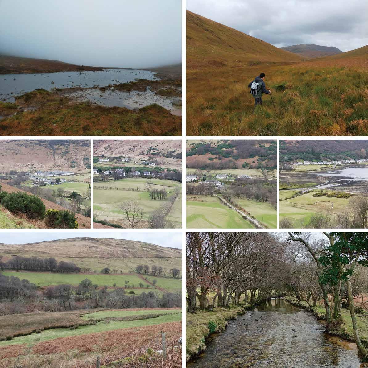
1.Loch na Davie (water source of Arran Whisky) 2.Upper river valley
3.Lochranza Distillery and the camp site 4.Lochranza village and the golf course 5.Golf course and the woodland 6.Estuary and the salt marsh 7.Grazing land and bracken field 8. River Chalmadale
3 7 8 4 5 6 2 1 01.

05
SITE CONTEXT


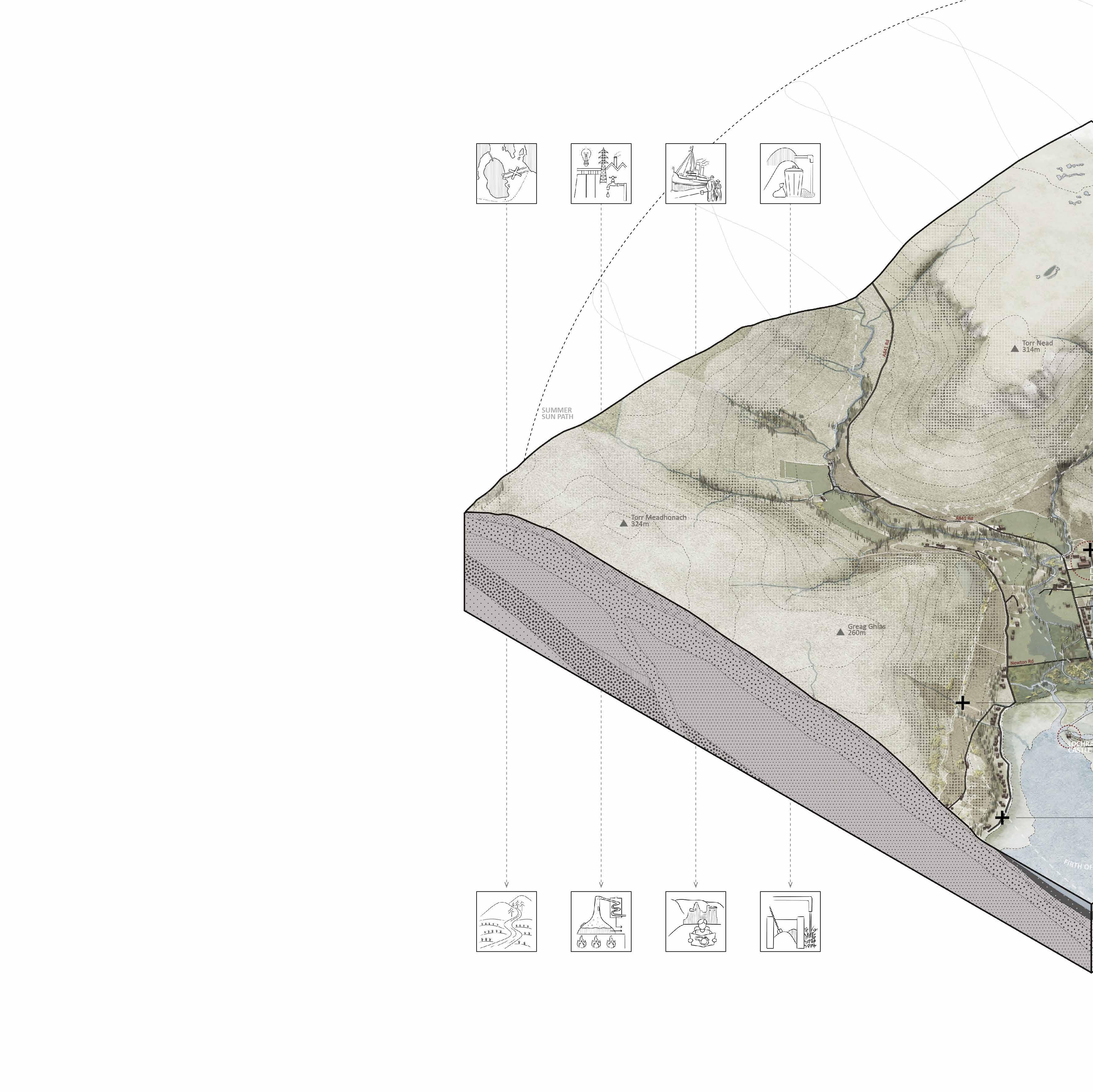
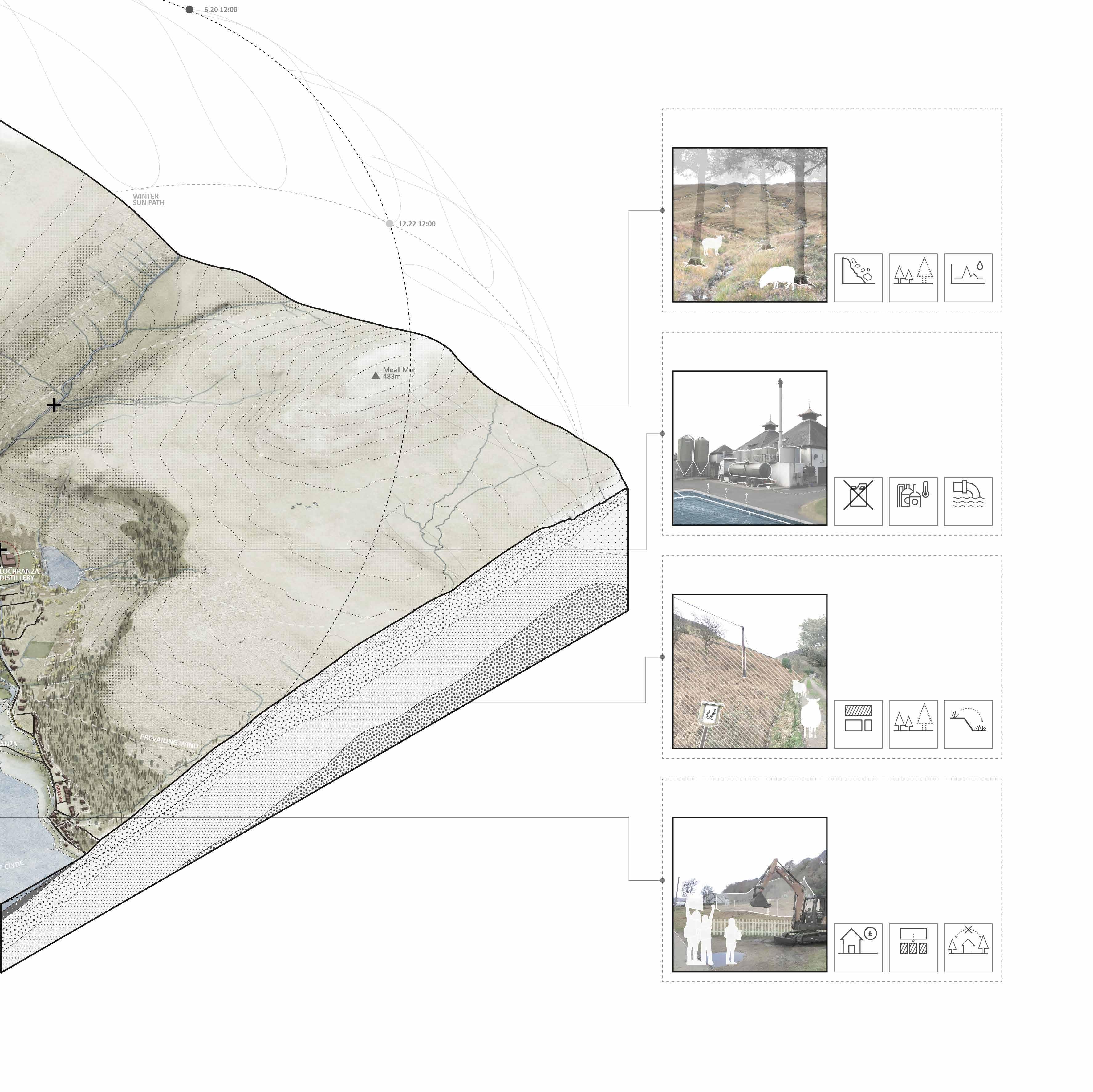
Lochranza is the northernmost village on the Isle of Arran and is home to around 200 people. Although located in remote area,Lochranza has a ferry terminal that connect Arran with Claonaig. Many tourists visit Arran from Lochranza will use this ferry line.
The island's most famous whisky distillery is located at the south of the village at the junction of River Chalmadale and Gleann Easan Biorach. Lochranza is not only famours for its distillery but also the historical castle, and geology studing site at the coastal area.
In the context of climate change, both the village and the island are facing constant environmental and social challenges.
TENSIONS BETWEEN RESOURCES AND DEVELOPMENT
WHISKY TOWNSHIP
The Lochranza distillery which now producing world-renowned whisky, not only provides employment for the local community, but also attrats tourists all-around the world.
As a resources and energy intensive industry, the distillery has close relationships with local resource, energy and waste management.
The efficient use of waste heat and by-products from whisky making and a stronger relationship with the local community on raw materials production and waste treatment will help to reduce the carbon footprint of whisky production and improve the sustainability of the local livelihoods.
POSSIBILITIES BETWEEN WHISKY MAKING AND SUSTAINABLE TOWNSHIP
1 4
Heather grassland Whisky distillery SITE Improved grassland Arable Waterbody Settlements Forestry plantation Natural woodland
OF ARRAN
ISLE
Lochranza Brodick To Ardrossan
1km Unstable supply chain for resources and energyvulnerable ferry line Water source protection and raw materials production Temporary Resource shortages during the peak tourist season Use the by-products and surplus energy from the distillery Impact of turism onthe living cost (house prices) Community based tourism Lack of local waste treatment sites and facilities Collaborated local waste mangement 06
To Claonaig
SITE PROBLEMS
Upstream land degradation
Most of the forests were disappeared 200 years ago as results of overlogging and grazing. The steep terrain and wet climate have led to serious erosion problems in the upstream areas. Woodland restoration is taking place in many parts of Arran, but the wet soil conditions make it difficult for trees to grow, and the terrain also limits the access of heavy equipment.
Unsustainable resources & waste management
The distillery is producing tons of cooling water (30-40°C) through the distillation process, which is dischargs into a cooling pool within the plant and then dischargs into the river. Byproducts (pot ale & draff)from the distillery are transported by trucks to the southern farmlands and most of the waste water is discharges to the sea via pipelines.
Land abandonment & expansion of invasive plants

Due to the topography and diverse natural water bodies, the land available for production and housing at Lochranza is very limited. However, pastures that have been abandoned are being taken over by bracken, rhododendrons and other invasive plants. Almost 50% of the tradition pastures are occupied by these plants.
The population of Lochranza is only 200 people, but the village has 172 homes. About 40% of there homes are holiday homes and hotels. The new demand for housing has led to the occupation of a large amount of valuable open spaces. Almost all the plain around the estuary is occupied by homes and hotels.
2 3 5 6 1 2 3 4 5 6
Acid grassland Water body Gleann Easan Biorach Heather grassland Flooding area Loch a' Mhuilinn Woodland House Lochranza golf course Improved grassland Road & Lane Lochranza Outdoor Centre Salt marsh Bracken field Soil erosion Lochranza Church Bare rock Glen Chalmadale Housing crisis No more holiday homes! Cooling water Grains & fuels from mainland Land abandonment Unstable Source supply Soil erosion Open space occupation Plant degradation Waste heat Plant degradation Corridors shut down Invasive species expansion Waste water Unstable water flow N
07
Holiday homes & empty homes
DESIGN STRATEGIES
1. Grazing and logging has led to tree decline and bracken expansion.
2. Heavy erosion has created barren topsoil and numerous small streams on the hillside.
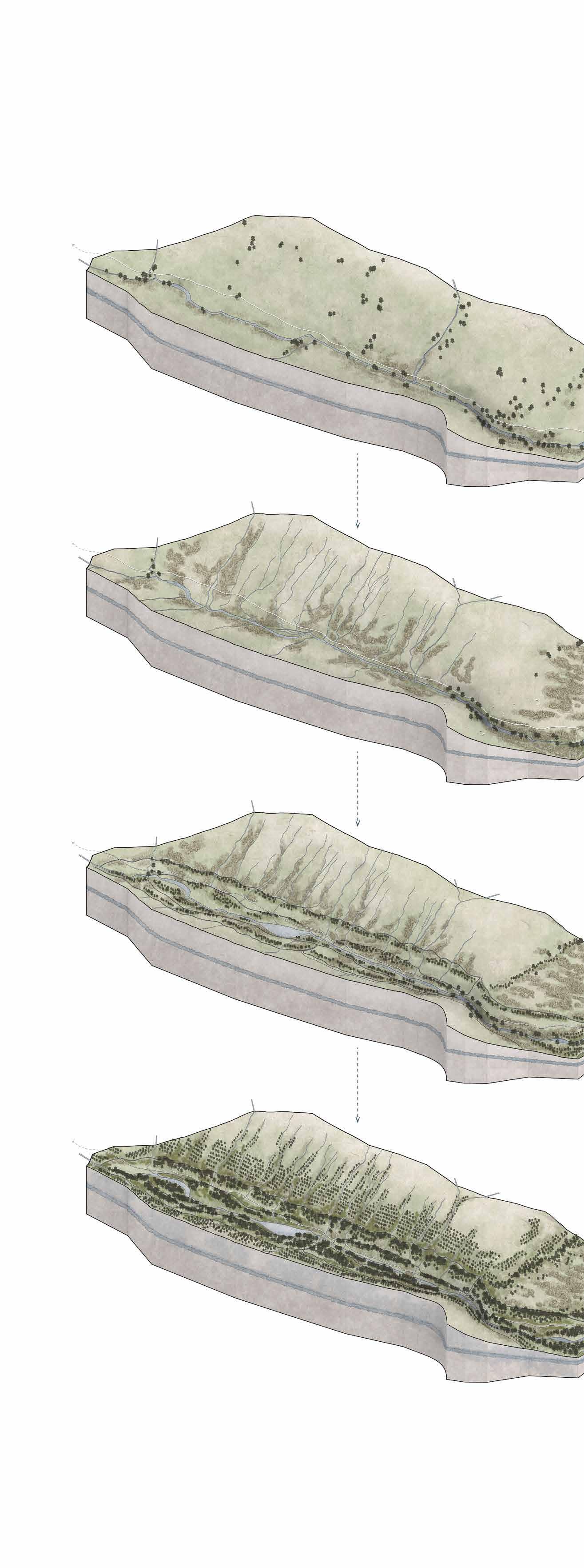
1. Introduce ditches to reduce hillside erosion and prepare soil for woodland restoration (trees transplanted from the plants nursery).
2. Plant trees and harvest bracken for composting to prepare for the next phase of reforestation.
3.Introduce storage ponds for reducing the risk of flooding and water crisis.
1. Restore the heathland on higher hillside.
2. Control invasive plants such as bracken and rhododendron, restore the forest floor.
3. Second phase of forestation (trees transplanted from the mature woodland).
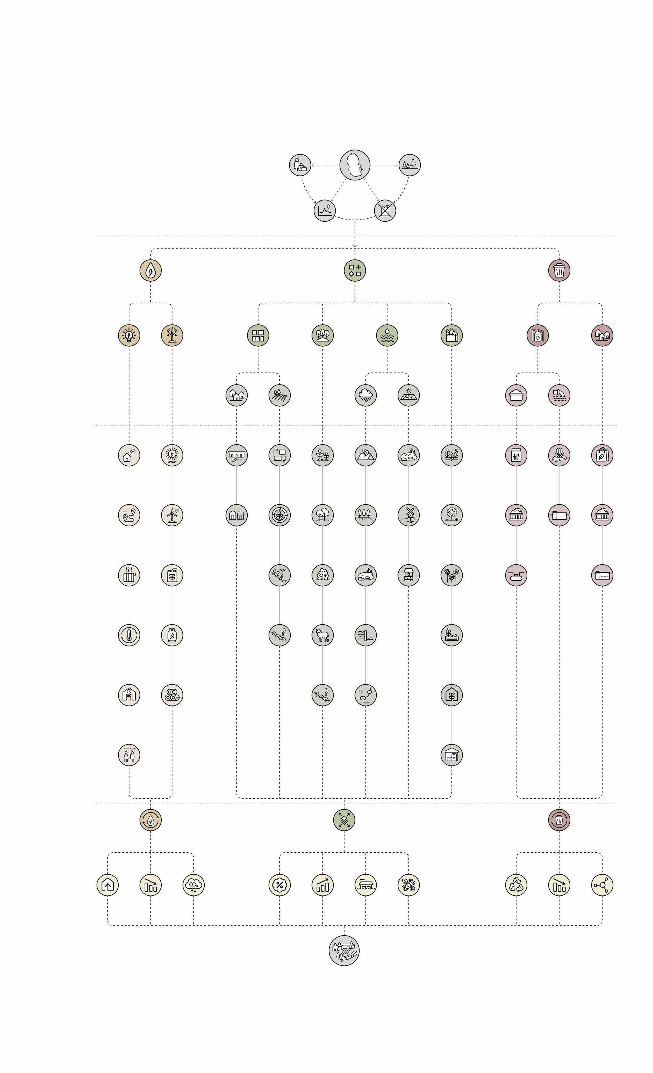
Energy Consumption Maximise natural light Plants nursery Storage pond & Loch Dry Season Multidwelling unit Residential Land Reduce longdistance mobility Woodland restoration Windpump Portable house Unified heating Forest floor conservation Well Reuse distillery waste heat Agroforestry Community canteen Improve energy selfsufficiency Improve food selfsufficiency Invasive species control Public showers Energy Production Energy METHODOLOGY STRATEGIES RESULTS Tourist-based Economy Environmental Degradation Isle of Arran Unstable Energy & Fuel Supply Seasonal Resources (water) Shortage Integrated Energy Management Flexible Resource Management
Sustainable Whisky Township Sustainable Waste Management Resources Waste Land Resources Vegetation Resources Water Resources Food Resources Distillery Waste Household Waste Waterwheels Green roofs Wet Season Cropland By-products for feed Storage pond Streams Waterfalls Swales & Ditches Mature Woodland Second phase of forestation Recharged groundwater Gleann Easan Biorach Solid Waste Bio packaging Constructed wetland Waste Water Bio septic tank Controlled seasonal grazing Productive Land Windmills Catchment woodland Hillside Orchard Composting Facilities Composting Facilities 4-year crop rotation Bracken fuel Wetland Pollinator garden biomass plant Bio septic tank Soil erosion control Biogas Weir Community food garden Invasive species control Firewood logs Reduce energy consumption Reduce industrial & household waste Improve land productivity Reduce carbon emissions Improve the use of byproducts Reduce nonrecyclable materials Reduce flooding risk Improve biodiversity Bioswale & Drainage system Greenhouse Food storage facilities
Loch na Davie Gleann Easan Biorach - upstream 08
GLACIER VALLEY
Bracken field
1. Whisky distillery using water from Gleann Easan Biorach brings new industry to Lochranza.
2. The main industry has changed from agriculture to tourism, some pastures have been abandoned.
3. Fertile land has been occupied by bracken.
Livestock and water flows accelerate the expansion of bracken.
1. Introduce new multi dwelling units which will alleviate the housing and land shortage in the village.
2. Restore the the field of bracken to cropland.
3. Expand existing water bodies and woodland for reducing the risk of flooding and water crisis.
Storage pond
Multi dwelling unit
1. Introduce community food garden and flower garden to attract pollinators to the site.
2. Woodland expansion and the formation of new green corridors
Windmill
Community garden
Constructed wetland Catchment woodland provides stable water source for the loch.
Chalmadale
LOCHRANZA VILLAGE CENTRE
Pasture
1. The main industry has changed from agriculture to tourism, hillside pastures have been abandoned.
2. The increase in housing and holiday homes has led to a shortage of land.
3. River side pastures have been transformed into golf course and cool season pasture.
LOCHRANZA PAST
AREA (1800S)
Golf course
Abandoned pasture Lochranza Distillery (Founded in 1995)
Cropland Plants nursery
Bracken field
1. Restore the woodland and create windbraks for pastrures and residential area.
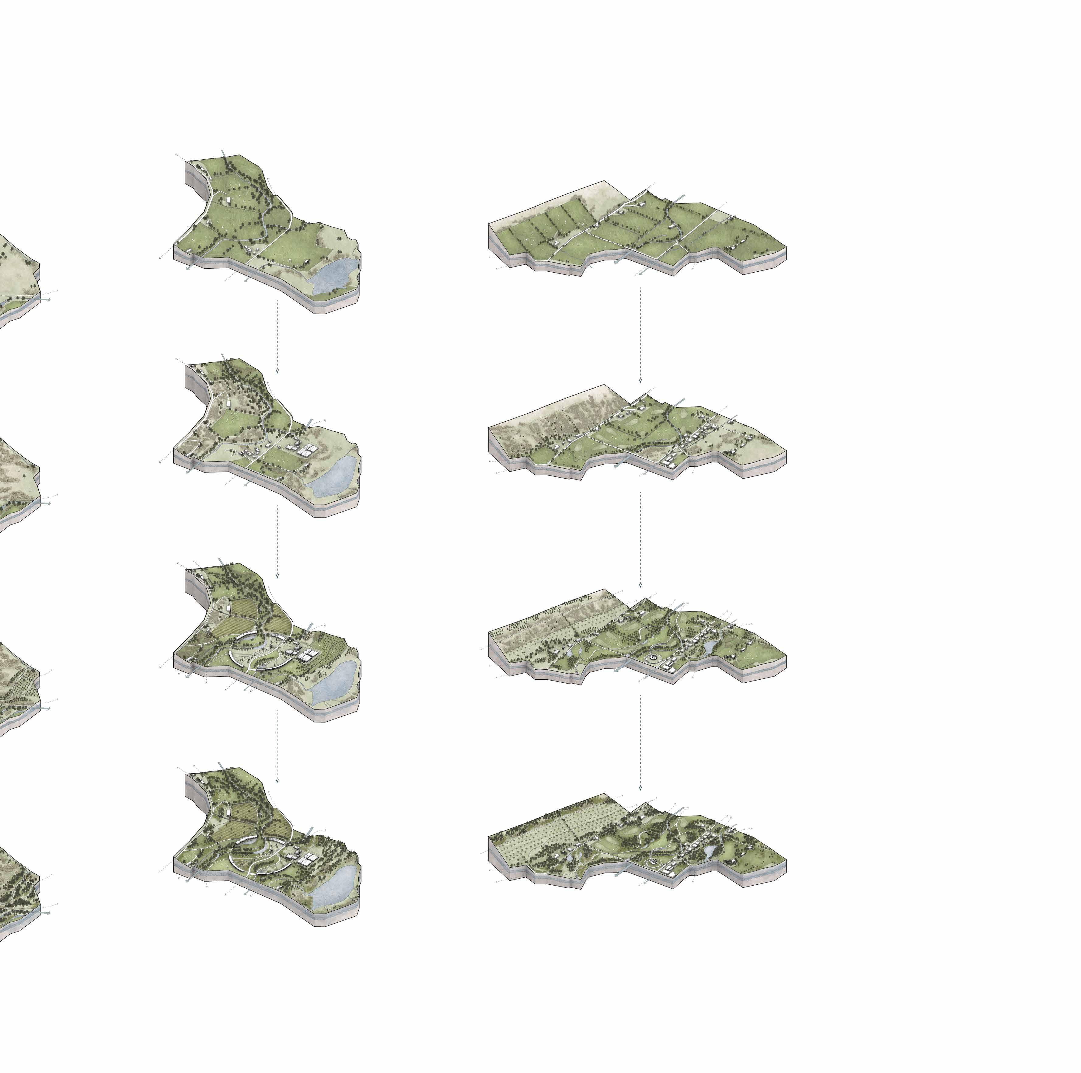
2. Control the bracken field and create hillside orchard.
3. Harvest bracken for composting to improve the soil fertility of the orchard.
4. Introduce new pathway system and infrastructure.
Pond
PRESENT
Greenhouse Communal facilities
Processed bracken as biofuel for the distillery.
Fruit trees produce local products for the community and distillery.
Gleann Easan Biorach & Glen Chalmadale - midstream
Orchard
1. Introduce wetland at the coastal area, which create new habitats for wildlife.
2. Plant wildflower in the golf course to create diverse landscape and attract pollinators.
3. Woodland expansion and the formation of new green corridors
Windbreaks woodland
Portable house Windmill & Workshop
10-50 years
EARLY ESTABLISHMENT (2032-2072)
Constructed wetland
Golf course & Cool season pasture
FUTURE ESTABLISHMENT (2072-2122)
Coastal wetland
Windmill & Library
Firth of Clyde
Food Production Food Production Food Production Food Production Energy Efficiency Energy Efficiency Energy Efficiency Energy Efficiency Renewable Energy Renewable Energy Renewable Energy Renewable Energy Water Resources Water Resources Water Resources Water Resources 2 2 2 2 6 6 6 6 10 10 10 10 Household Waste Household Waste Household Waste Household Waste Tourism Waste Tourism Waste Tourism Waste Tourism Waste Raw Material Production Raw Material Production Raw Material Production Raw Material Production Distillery Waste Distillery Waste Distillery Waste Distillery Waste Energy Consumption Energy Consumption Energy Consumption Energy Consumption
Ditches DYNAMIC SYSTEM
Glen
Loch a' Mhuilinn Ditches Water from Loch a' Mhuilinn
JUNCTION
CONDITIONS (2022)
Glen Chalmadale - downstream 09
50-100
years
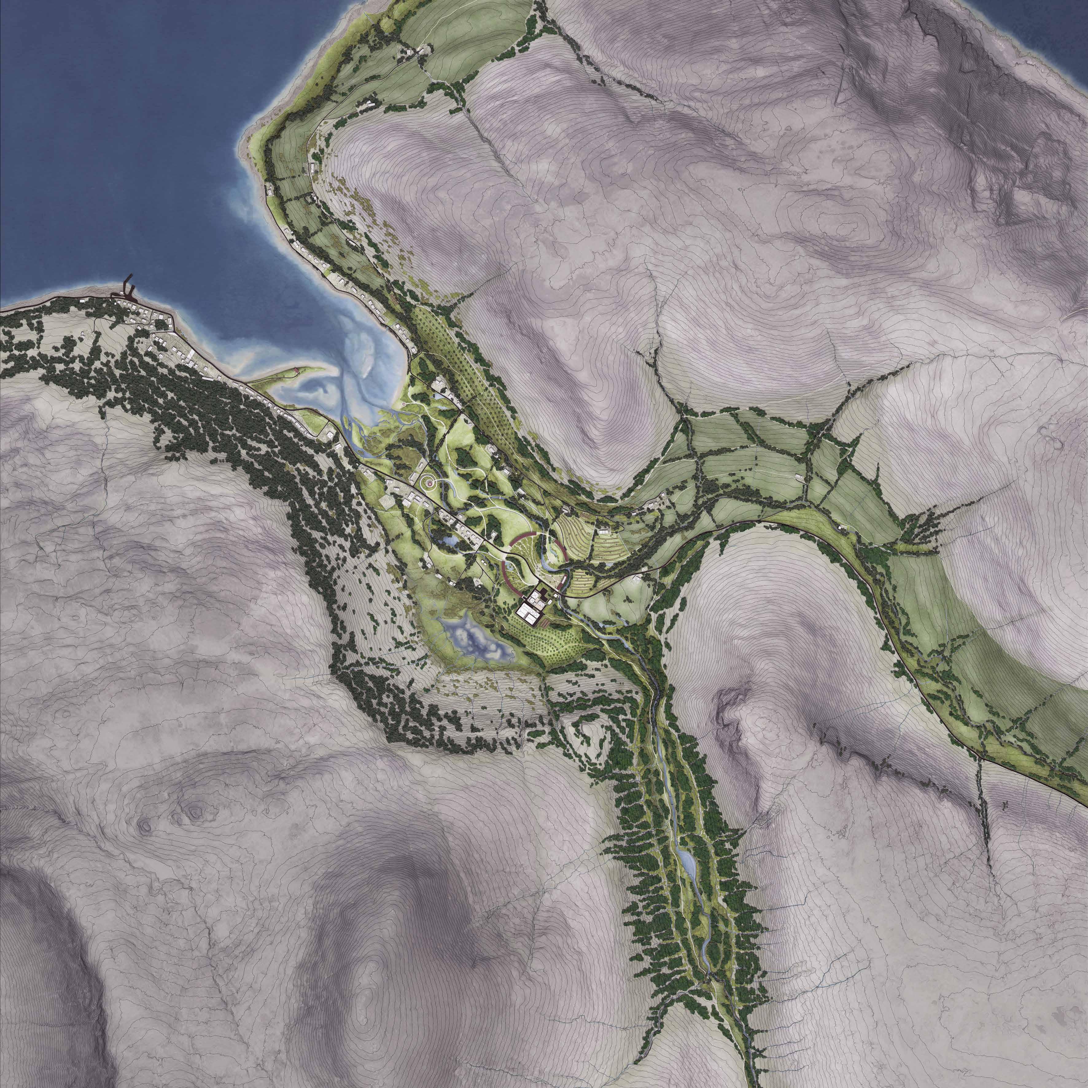

0 200 100 500m N 1 2 4 7 5 3 6 12 8 9 11 13 14 10 6 Scale: 1/5000@A0 LEGEND 1 Lochranza Ferry Terminal 2 Lochranza Castle 3 Field Study Centre 4 Library & Observation Spot 5 Community Workshop 6 Lochranza Golf Course 7 Orchard 8 Water Treatment Wetland 9 Water Wheel 10 Composting Site 11 Food Garden 12 Lochranza Distillery 13 Nursery 14 Hydropower Plant Isle of Arran SITE SUSTAINABLE WHISKY TOWNSHIP MASTER PLAN 10
1.The salt marsh area with its diverse ecological functions will be protected as part of the coastal ecological corridor.
2.The existing woodland on the shaded slopes will act as an ecological corridor and important landscape structure within the conservation area.
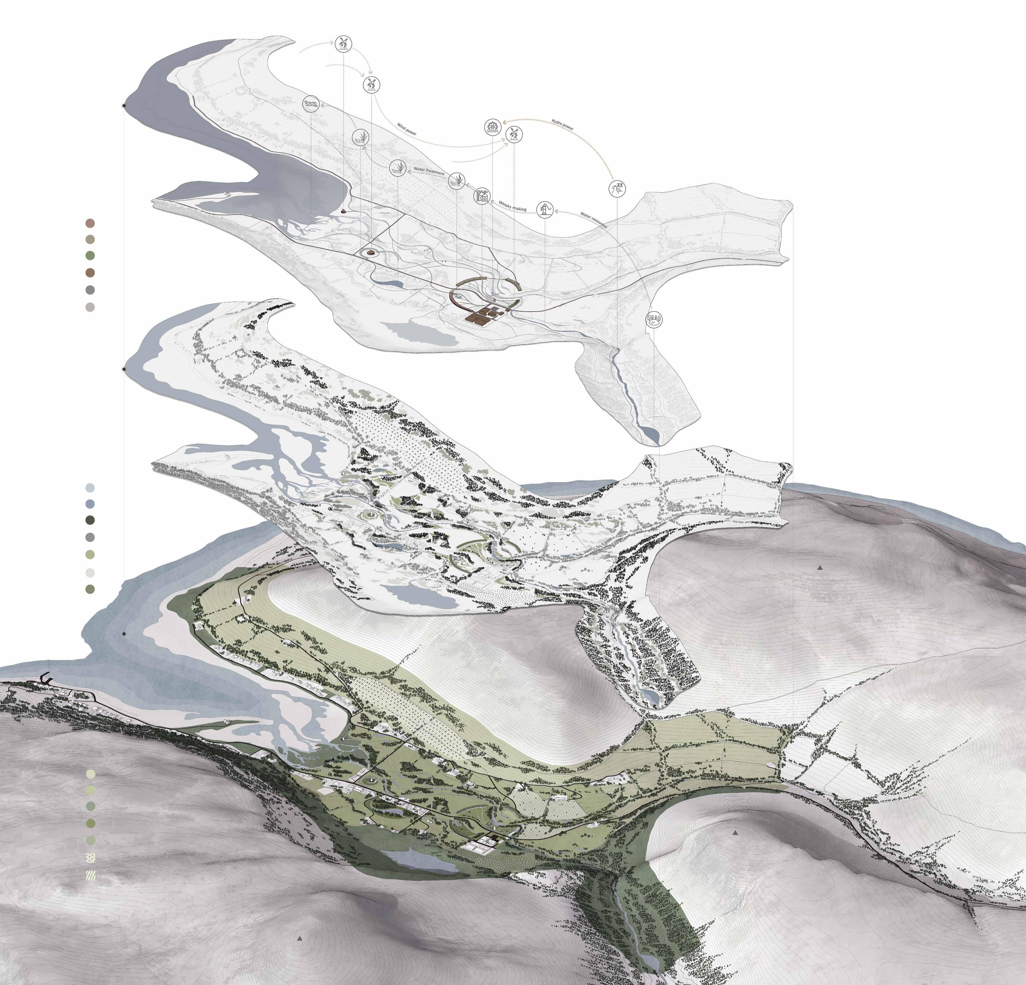
3.The northern slopes with good light conditions will be used as orchard areas after the removal of the bracken.
4.Flat meadows and croplands in lower areas will be used as pastures for livestocks during autumn and winter, protecting them through the cold season while replenishing soil fertility.
5.The flat, high-quality land near the community will be used for grain rotations.
6.The river valley will become part of the conservation area and the woodland will be restored in phases to cope with extreme weather and soil erosion.
7.Trees will also be planted around the orchard to reduce the impact of prevailing westerly wind.
8.The expansion of the woodland over the existing vegetation will enhance the biodiversity of the golf course and guide the wind into the core area of the community.
9.Green roofs and community wildflower gardens will promote the integration of living areas with the surrounding environment.
10.Trees are interspersed with shrubs and grassland to ensure the diversity of the forest floor, slow down surface run-off and reduce the risk of erosion.
11.The windmill near the estuary will be used for bracken processing and provide electricity for its attached small library. It will also serve as a viewing spot for observing wildlife living in the costal area.
12.The windmill in front of the field study centre will provide power for woodworking and some DIY activities, while an attached small wetland will enhance the diversity of habitats near the estuary.
13.The new pathway system will enhance the accessibility of the site. The portable chalet alone the pathway will enhance the capacity of visitors to the village during the tourist season.
14.The ring shape structure will provide locals with houses and functional facilities, such as public showers, kitchen and local market. It also has productive facilities, such as herb garden and greenhouse. The whole facility will use the surplus energy and by-product from the distillery to reduce daily energy and resources consumption.
1 3 5 4 10 6 2 9 7 8 11 12 14 13 LEGEND Functional facility Existing water body Cool season pasture (Sep-Mar) Dwelling Proposed water body Warm season pasture (Apr-Aug) Green house Proposed trees Conservation area Distillery Existing trees Constructed wetland Main road Proposed shrub & groundcover Plant nursery Pathway Existing shrub & groundcover Orchard Green roof Cultivation land MEALL MOR LOCH A'MHUILINN LOCH RANZA To Newton Coastal Path To Loch na Davie To Sannox To Laggan Cottage To Pirnmill TORR NEAD 314m 324m TORR MEADHONACH Infrastructure Landscape Land Use 483m
CASK COMMUNITY - INFIELD
The design of the new town centre is based on traditional Scottish crofting townships where the land has been divided into infield and outfied.
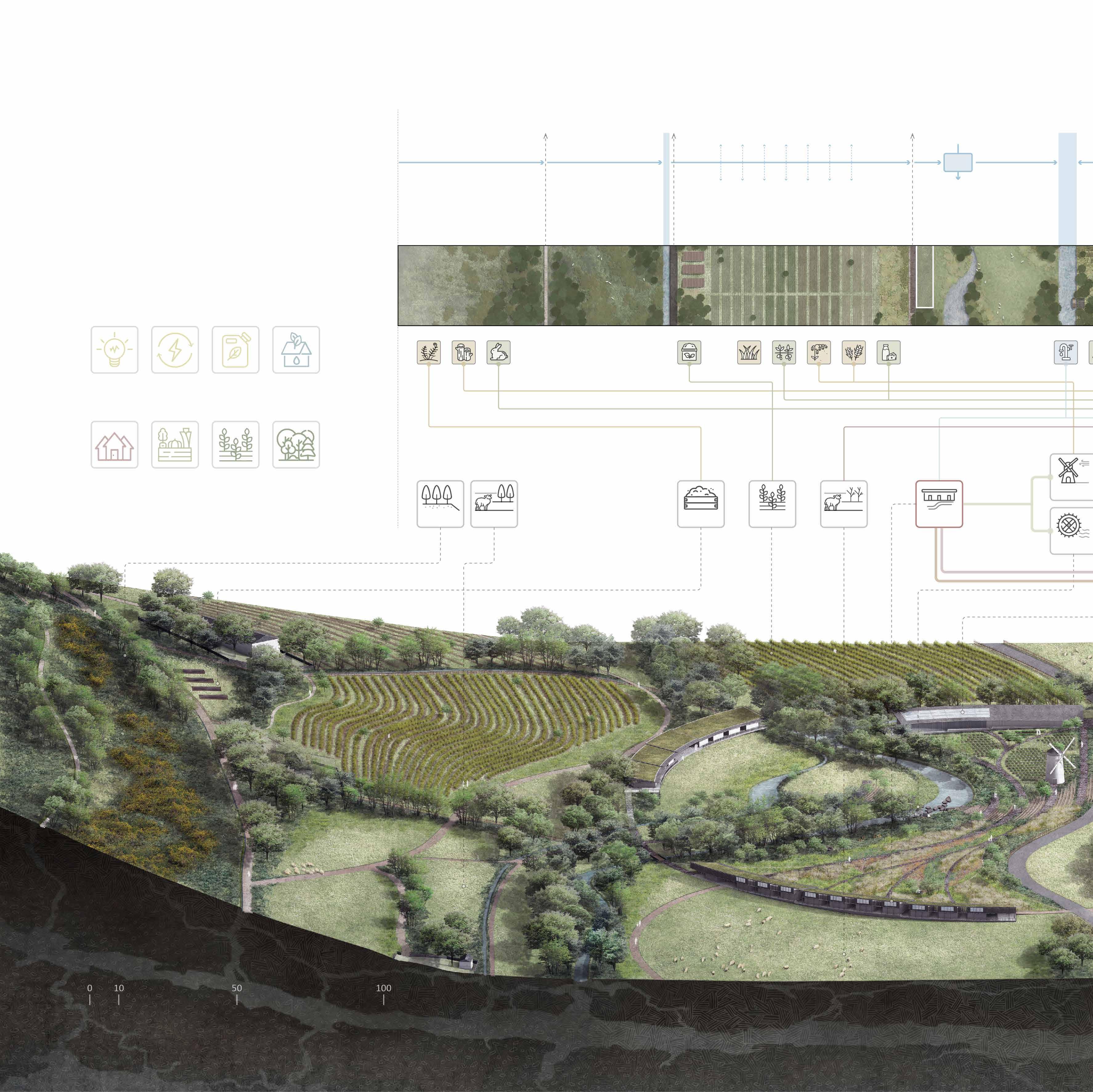
The infield is centred on the whisky distillery, communal housing and facilities, gardens and farmland, will undertake the main production and processing activities with by-products from the distillery and other areas. The outfield will act as seasonal pastures and ecological reserves to create green barriers around the community.
The intensive layout of the facilities will help to increase energy efficiency and reduce waste of land resources, while the production of resources and waste recycling will help to increase the village's selfsufficiency.
Eco electricity generation for 50 families Multidwelling unit 20 families Community food garden 2500 m 2 Community cropland 4.9 ha Woodland buffers 6.5 ha Annual heating enegy saving 120000 kWh Annual biofuel production 150000 kWh Green roof for water cellection 4000 m 2 1.Reduce soil erosion 2.Produce raw materials and foodstuffs 3.Create habitats and corridors for wildlife 1.Produce grains for the distillery 2.Produce food for the community 3.Produce compost 1.Provide houses for locals and visitors 2.Store water for livestocks 3.Provide openspace for events 1.Attract pollinators 4 1 7 5 2 3 8 6
Role in energy & resources & waste management Raw materials & products Infrastructure & facilities Land use Water Woodland Buffer (Windbreaks, Catchment woodland) Cropland (4 years crop rotation, Composting site) Wildflower Meadow Ditch Surface runoff Irrigation Ditch Pond River Residential Area (Dwelling unit, Openspace) Windmill Water Grass Bracken Wild animals control (Wild rabbit & Red deer) Electricity Phased bracken management Compost Potato Firewood Oats Wild Meat Barley Dairy Water wheel Multidwelling unit Cool-season pasture Cropland Composting site Warm-season pasture Hillside woodland
1.Produce vegetables and herbs 2.Produce honey 3.Process foodstuffs and raw materials 1.Provide public facilities for locals and visitors 2.Process waste water from the distillery 3.Produce biogas for the distillery and community 1.Grow trees for upstream forestation 2.Composting solid waste from the distillery 1.Store water for the community 2.Create wetland habitats for wildlife 1.Reduce soil erosion 3.Create habitats for wildlife LEGEND 1 Cropland 2 Long-term houses 3 Short-term houses 4 Beehive 5 Flower garden 6 Windmill 7 Food & Herb garden 8 Greenhouse & Storage house 9 Lochranza Distillery (visitor centre) 10 Lochranza Distillery (cellar) 11 Composting site 12 Plant nursery 13 Constructed wetland 14 Observation deck 13 10 11 12 9 14 SITE LOCATION Ditch Surface runoff Irrigation Ditch Irrigation Ditch Loch a'mhuilinn Community Garden & Openspace Distillery & Communal Facilities (Public kitchen & shower, Local market, Constructed wetland, Biomass, openspace) Plant Nursery Woodland Buffer (Windbreaks) Wetland Area Hillside Woodland (Catchment woodland) Biogas digester Local market Public kitchen Public shower Whisky distillery Composting site Plant nursery Woodland buffers Septic tank Food garden Bracken logs - biofule Livestock feed Waste water Biogas Preprocessed by the windmill Upstream forest restoration Waste Heat (cooling water) Chanterelles & Cauliflower fungus Vegs Herbs Honey Grain Whisky Pot Ale Draff Compost Sapling Bracken Fungi White Willow (Salix alba) Constructed wetland 13
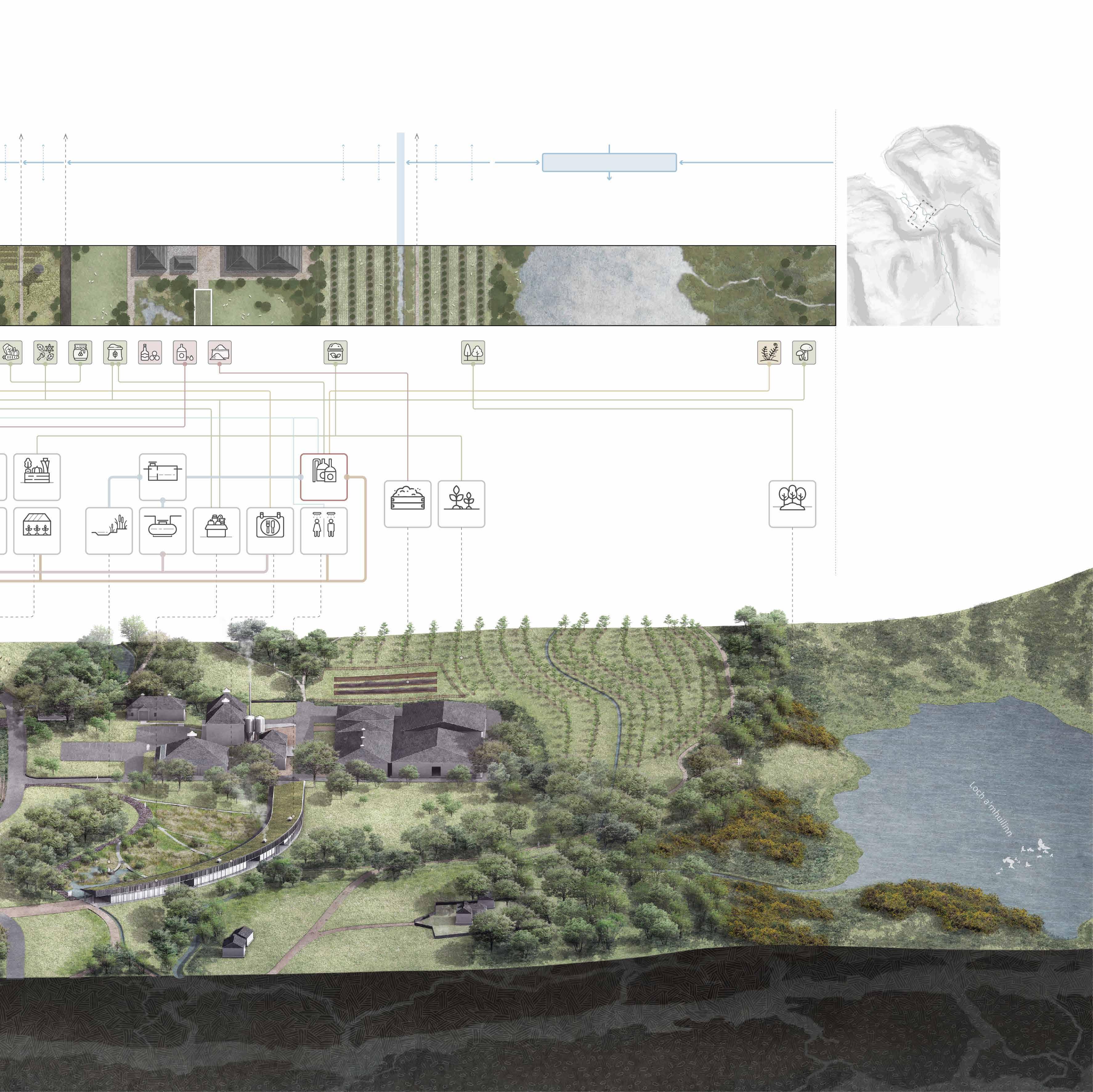
CASK COMMUNITY - OUTFIELD
To preserve part of the golf course while increase the site's biodiversity and resilience to climate change, the old town centre and golf course will be transformed from a single golf course-pasture to a diverse landscape with woodland, wildflower meadows, wetlands etc.
Portable houses in the course will alleviate housing pressures during the tourist season. Abandoned hillside pastures will be transformed into orchards and woodlands based on the management of the bracken to provide foodstuffs for the community while reducing soil erosion.
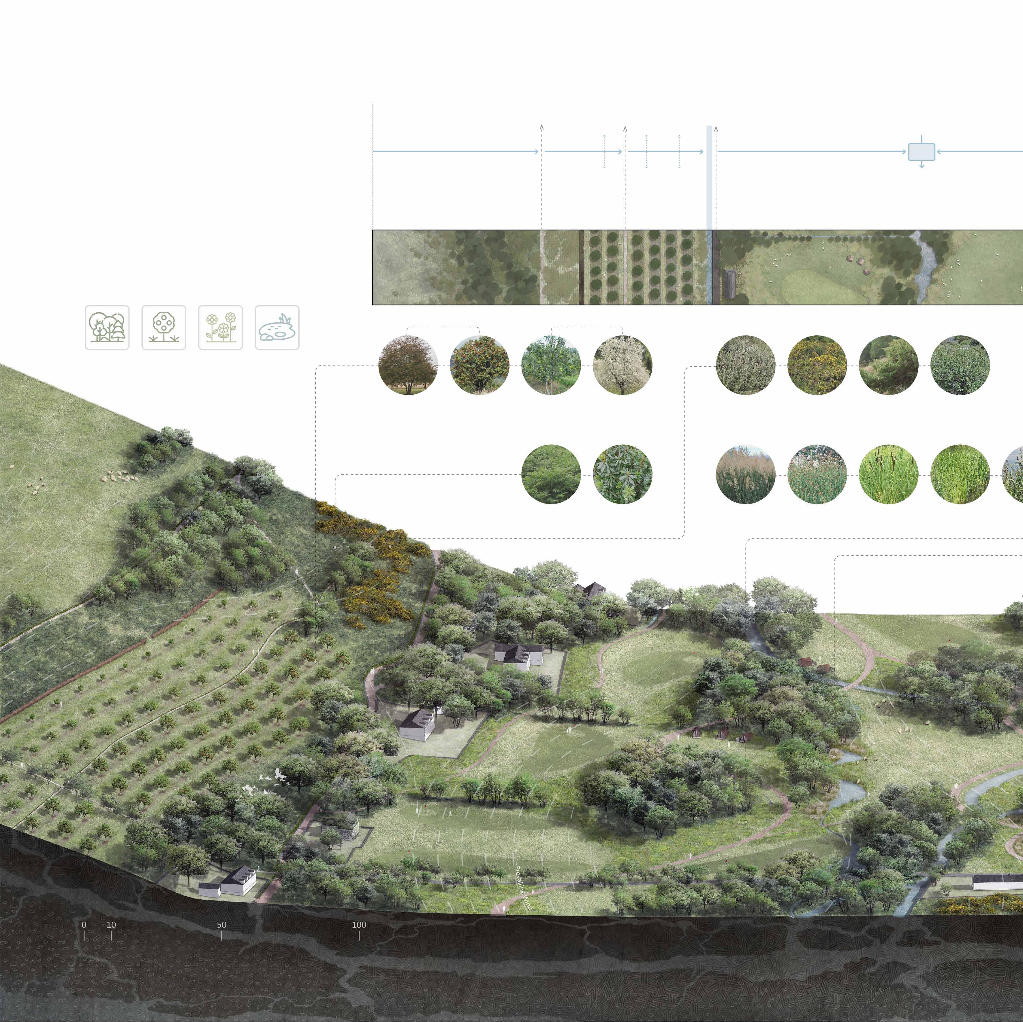
The windmill near the Field Study Centre will take advantage of the plentiful wind resources at the waterfront to process food and raw materials and provide new study sites for visiting students.
Woodland Buffer (Windbreaks, Catchment woodland)
Hawthorn (Crataegus monogyna)
Bracken Field Buffers &
Orchard (Bracken fence, Wildflower meadow)
Irrigation Ditch
1.Produce fruits for the community
2.Reduce soil erosion
3.Produce bracken compost and bracken fuels
1.Keep livestocks during cool season
2.Store water for livestocks
3.Recharge groundwater and reduce the impact of seawater
Poor
Plants Rowan (Sorbus aucuparia) Gorse (Ulex europeaus)
'Discovery' apple (Malus domestica)
Wild cherry (Prunus avium)
Creeping willow (Salix repens)
Bracken (Pteridium aquilinum)
Rhododendron (Rhododendron ponticum)
Common reed (Phragmites australis)
Common clubrush (Scirpus lacustris)
Wetland
Creeping juniper (Juniperus horizontalis)
Dwarf birch (Betula nana)
Great reedmace (Typha latifolia)
Golf Course & Cool Season Pasture (Windbreaks, Wildflower meadow, Wetland, Portable Greater (Carex
Branched Bur-reed (Sparganium erectum)
1.Reduce soil erosion 2.Produce raw materials and foodstuffs
3.Create habitats and corridors for wildlife
Woodland restoration 5.5 ha Community orchard 6.4 ha Wildflower meadows 2.7 ha Wetland & artificial water body 9000 m 2 4.Attract pollinators 5.Provide temporary 6.Create diverse 1 2 3 4 6 7 5 9 8
Role in energy & resources & waste management Land use Water
Ditch Surface runoff
Houses
Orchard Shrub Wetland Hedge Fruit Trees Main Fruit Trees
Invasive Plants Water Purifying Plants
Soil
Irrigation Ditch
Residential Area Wetland Area (Woodland Buffer)

Wetland Pond River
Cool Season Pasture (Windbreaks, Wildflower meadow)
Hillside Woodland (Catchment woodland) SITE
Surface runoff
Wet Soil Trees Evergreen Trees
LEGEND
Greater pond sedge (Carex riparia)
Woodland
Alder (Alnus glutinosa)
1 Cool season pasture
2 Bracken barrier (compost fence)
3 Orchard
4 Lochranza golf course
5 Wildflower meadow
Silver birch (Betula pendula)
Aspen (Populus tremula)
Wet Soil Plants
Wych elm (Ulmus glabra)
Wildflower
Sessile oak (Quercus petraea)
White Willow (Salix alba) Ash (Fraxinus excelsior)
Common juniper (Juniperus communis)
Scots pine (Pinus sylvestris)
Medicinal Plants
Yew (Taxus baccata)
6 Portable houses
7 Wetland
8 Storage pond
9 Library & Observation Spot
10 Windmill & Workshop
11 Lochranza Outdoor Education & Activity Centre
12 Lochranza church
13 Wetland
Yellow iris (Iris pseudacorus)
Meadowsweet (Filipendula ulmaria)
Greater pond sedge (Carex riparia)
Red campion (Silene dioica)
Sneezewort (Achillea ptarmica)
Ribwort Plantain (Plantago lanceolata)
Self heal (Prunella vulgaris)
Oregano (Origanum vulgare)
1.Store and purify the upstream water 2.Create buffers between residential area and pastures pollinators temporary houses for visitors diverse landscapes for visitors and wildlife 1.Keep livestocks during cool season 2.Attract pollinators
erosion
raw materials and foodstuffs 3.Create habitats and corridors for wildlife
1.Reduce soil
2.Produce
10 11 12 13
Pasture houses) Ditch
15
LOCATION
'Renovate' Granton Castle Walled Garden
INFO Place: Granton, Edinburgh, Scotland
Year: 2021
Programme: Landscape Architecture Design: Context and Grounding
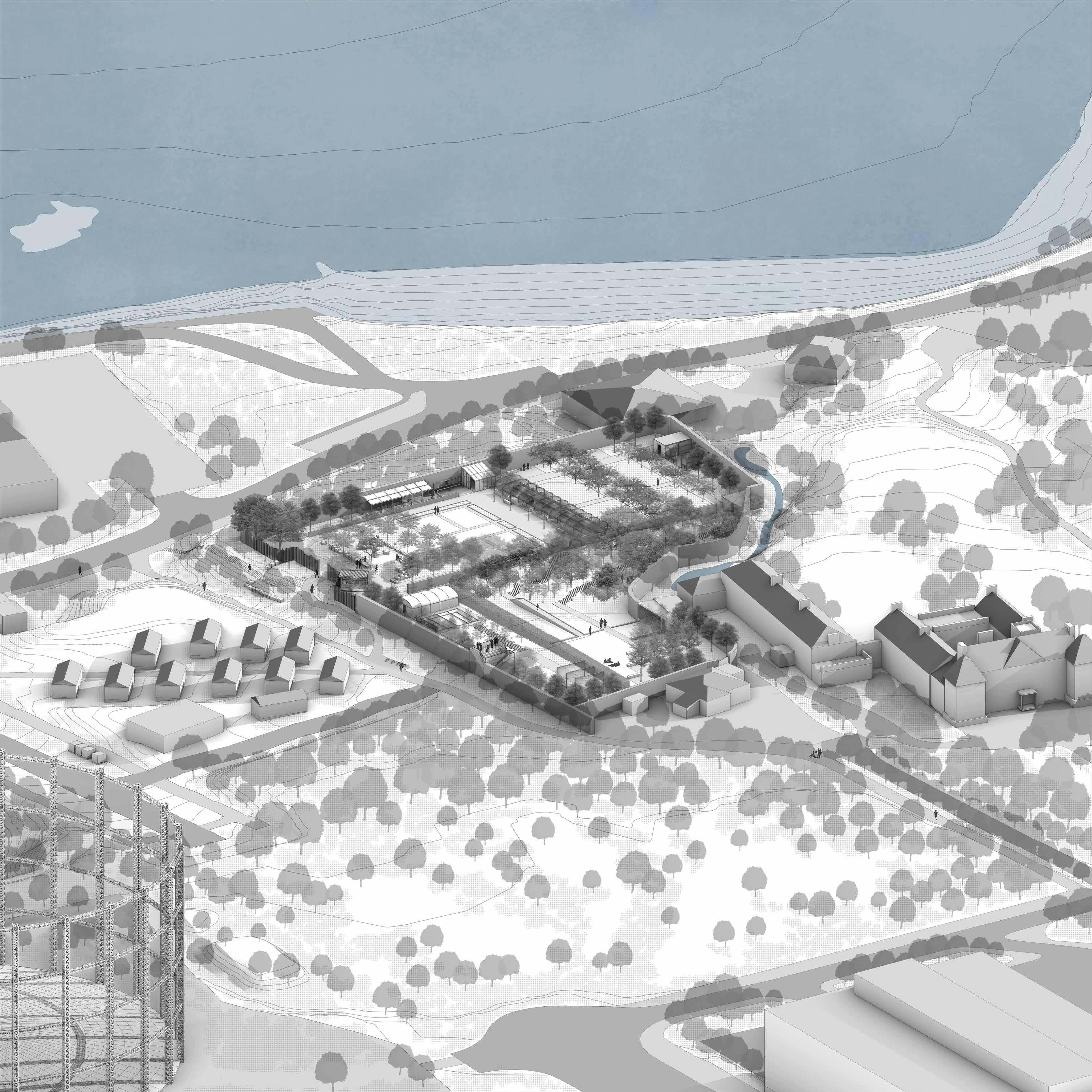
The Granton Castle Walled Garden is located at the coastal area of Edinburgh, facing the Firth of Forth. The castle was built in the 15th century and owned by The Duke of Buccleuch since the early 19th century. Grapes and apples were planted in the garden in this period, and the garden has become a local market garden for flowers during the 20th century.
The castle and manor house, which ceased to be used at the beginning of the 20th century, have been demolished, while the outer walls of the castle gardens have been preserved, as well as some partially preserved buildings such as the dovecote, which have been partially preserved but have lost their original function.
In 2017 the local community took back the garden from authorities and trying to reform it into a public garden. Community group and volunteers have reconstructed the glasshouse and dye workshop for production and educational events. They also maintain the vegetation in the garden, introduce wildflowers, and produce honey for local homeless and visitors.

After 4 years of work, local volunteers have already made initial progress in renovating the garden. They have planned several new spaces, such as the meditation space and cropland for recreational purpose and food production. However, due to the lack of a masterplan, the layout of the facilities and land in the gardens looks confusing. Walls and hedges make it easy for visitors to lose their way which makes it difficult to explore the whole garden.
In this project, I have set up a masterplan for the walled garden through systematic analysis and case studies of current volunteer works. The main purpose of my design is to solve the problem of the confusing layout of the land, pathway system and facilities. My design also aims to create a more open and historic public garden for locals and homeless who live in the Social Bite Village.
1 3 4 5 2
1.Main gate and temporary fence 2.Arrival space 3.Northern wall and the flower garden 4.View of the Highland from the south part of the garden 5.Ruins of the greenhouse and the community garden
02.
17
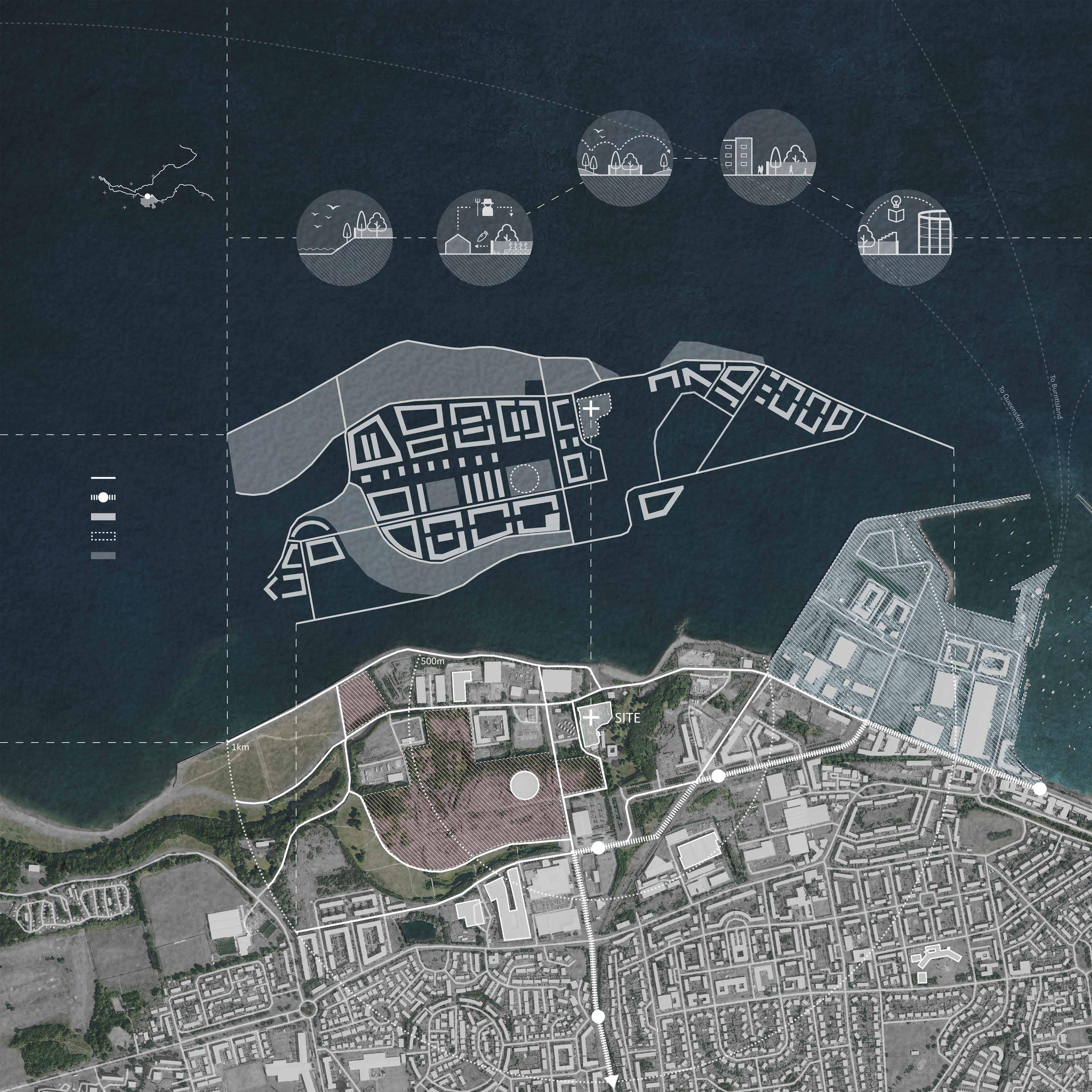
N Road system Firth of Forth Tramway & Station Residential & Commercial area Historical Asset Greenspace Granton is at the heart of Edinburgh’s Waterfront, 3 miles north of the City Centre. A 15-year massive regeneration project is taking place at the Granton waterfront to transform this former industrial area into a new coastal community. The Walled Garden which located at the center of this area needs to respond to these dramatic changes. Protecting Granton’s coastal habitats -2021 2035 2021 2035- 2025-2035 Offering jobs and skills training to homeless people Forming the Granton waterfront greenbelt Providing leisure space for the new community Providing place for natural and historical education
Gas Holder
College
National Museums
Social
Forthquarter
1 1 2 2 5 6 7 3 4 SITE
LEGEND Former Industrial land Granton Harbour To City Centre OPPORTUNITIES 18
1.
2. Edinburgh
3.
4. Granton Primary School 5. The
Bite Village 6. Granton Costal Parks 7.
Park
CONTEXT
SITE CONDITIONS & DESIGN STRATEGIES
03
Granton Walled Garden - 2021
With the regeneration of the former industrial area and the development of the new coastal community, the Granton Castle Walled Garden is facing a transformation from an enclosed semiprivate garden to an open urban parkland.
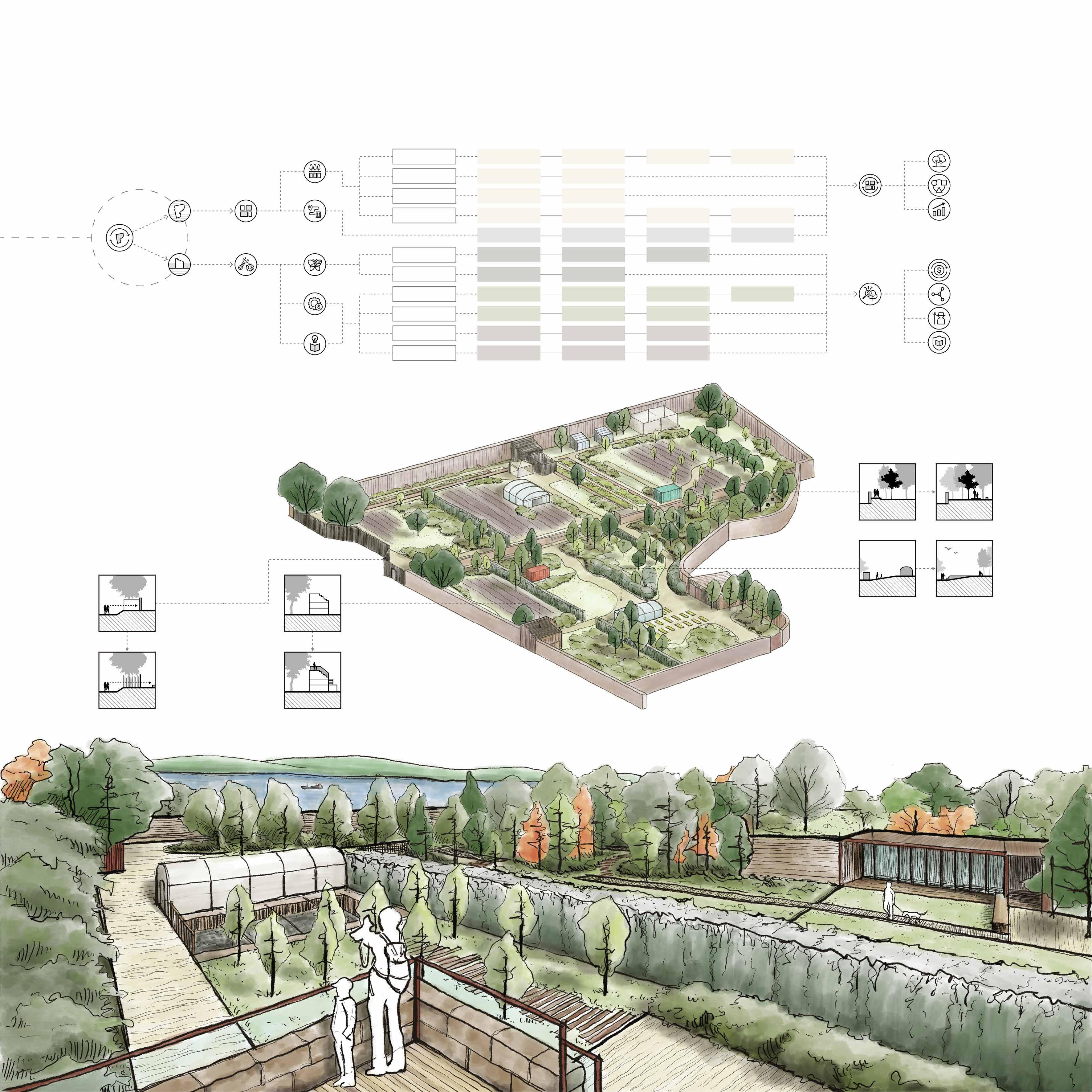
The garden is currently surrounded by old walls and temporary fences, making it very private. The new entrance will allow visitors to catch a glimpse view of the garden from outside.
Granton Walled Garden - 2035
There are several historic structures in the garden, such as the dovecote, walls of the greenhouse, and the warehouse. These structures can be renovated to meet the needs of the new garden.
Volunteers have created meditation spaces in the existing woodland. The new pathway system will make it easier for visitors to explore the woods and provide them with new landscape experiences.
04
The open space in the garden is now filled with many temporary facilities. Consolidating and relocating these facilities will provide more space for growing trees and holding events.
1 14 13 10 5 4 9 3 6 7 2 8 11 12 19
Site Entrance
01
Open space
Woodland
1. Entrance & Fence 2. New greenhouse 3. Old greenhouse heating room 4. New glasshouse 5. New beehive 6. Flower garden 7. Old apple trees 5-15 Years 0-5 Years Area Regeneration Abandoned Garden Landscape Planning Zoning Pathway System Diverse Urban Landscape Improve visitor experience Enhance landscape diversity Improve land productivity Sustainable production Closer relations with the community Increase employment opportunity Protect cultural heritage Multifunctional Urban Garden Ecology Water & Soil Conservation Historical Zone Arrival Entrance Food Growing Space Garden Space Orchard Catchment Woodland Woodland floor recovery Soil Improvement Time Tunnel & Meditation Zone Woodland Meditation Space Invasive Species Control Plant Nursery Present Zone Event Space Kitchen & Cafe Organic Crops Fruit Trees Bee Farm Greenhouse Future Zone Composting Space Plant Nursery Viewing Platform Greenhouse Flower Farm Pollinator Garden Wheelchair Friendly Garden Suggested Route Sightline Guide Simple Intersections Variation in Pavement Community Events Sightseeing Cultural Education Agriculture Education Local Market Environmental Education Vegetation Restoration Agriculture Gardening Tourism Education Finance Culture Function Restore STRATEGIES RESULTS Heritage Assets 8. Storage container #1 9. Dye workshop 10. Meditation space 11. Storage container #2 12. Abandoned garage 13. Flower planters 14. Abandoned dovecote 02 Heritage Assets
N
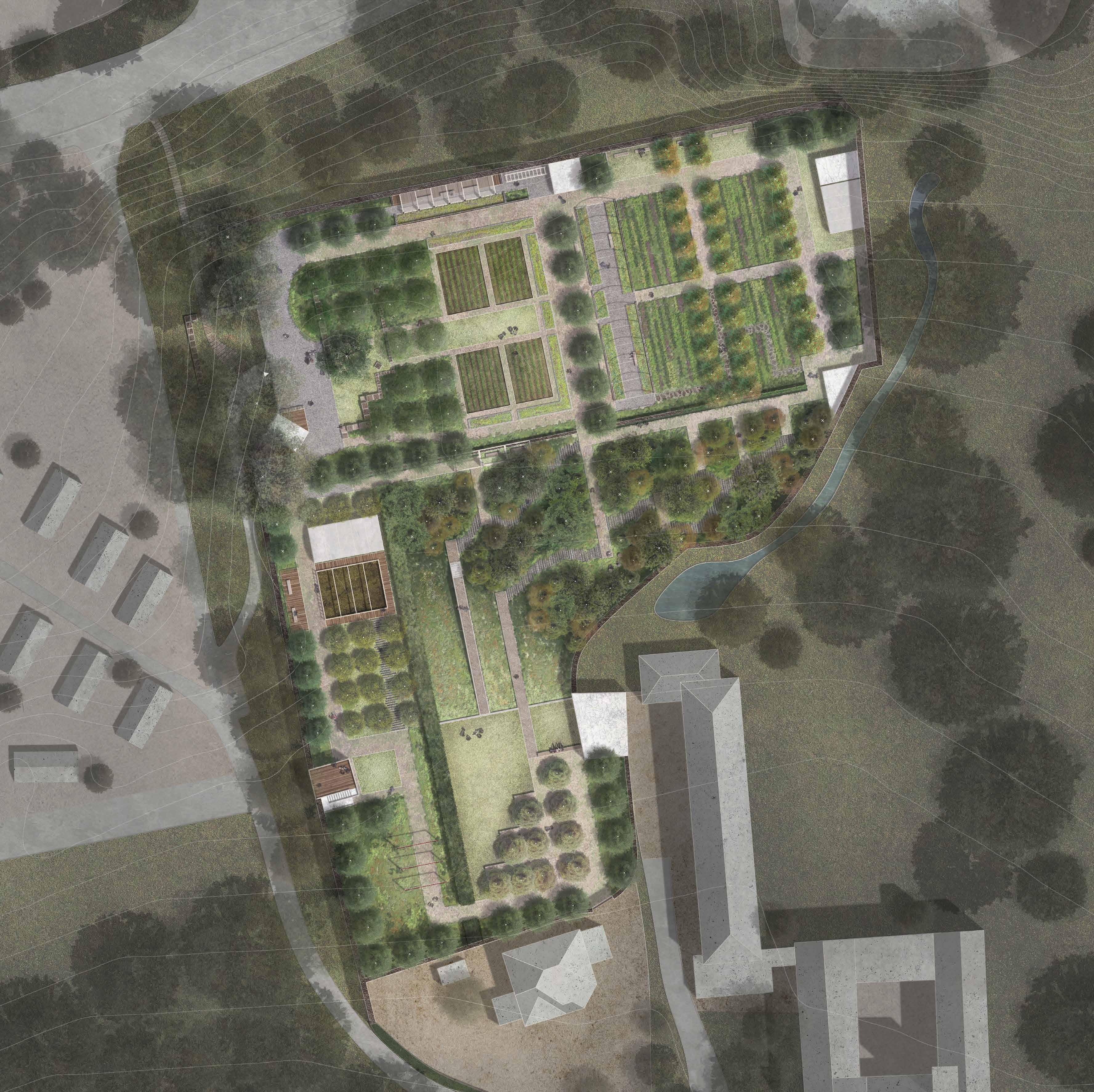
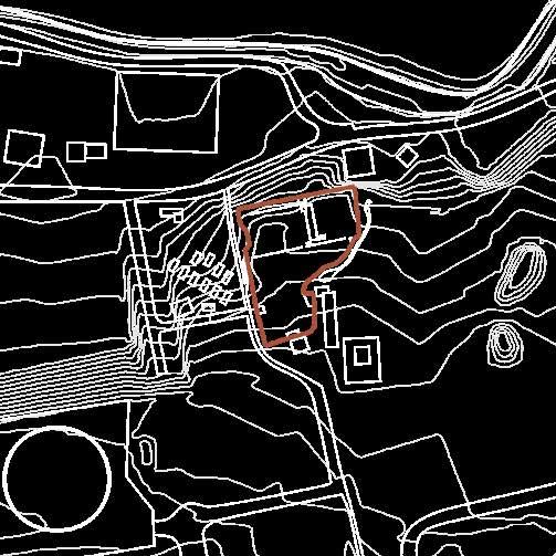


0 1 10 5 20m N 1 2 10 11 12 13 14 15 A B C D E F G H J K 3 4 5 6 7 8 9 6 1.Ganton Castle Walled Garden 2.Gas Holder 3.Granton Beach 4.Edinburgh Social Bite Village 1 2 3 4 Scale: 1/200@A1 GRANTON CASTLE
GARDEN
PLAN Woodland (Existing trees) Aspen (Populus tremula) Apple (Malus domestica) Wild cherry (Prunus avium) European Larch (Larix decidua) Woodland (Planted trees) STRUCTURES & FACILITIES GROUNDCOVER & PAVEMENT PLANTS 1 Information Centre 2 Gabion Wall 3 Pergpla #1 4 Drying Rack 5 Dye Workshop 6 Greenhouse (Temporary) 7 Storage House #1 8 Beehive A. Gravel Paving B. Lawn C. Field D. Wood Chip Paving E. Flowers & Vegetables F. Flower Field 9 Storage House #2 10 Pergpla #2 11 Kitchen & Cafe 12 Corten Steel Gate 13 Viewing Platform (Storage House #3) 14 Biomass (Compost) 15 Greenhouse G. Stone Paving #1 H. Timber Paving #1 I. Wild flower J. Stone Paving #2 K. Timber Paving #2 20
WALLED
MASTER
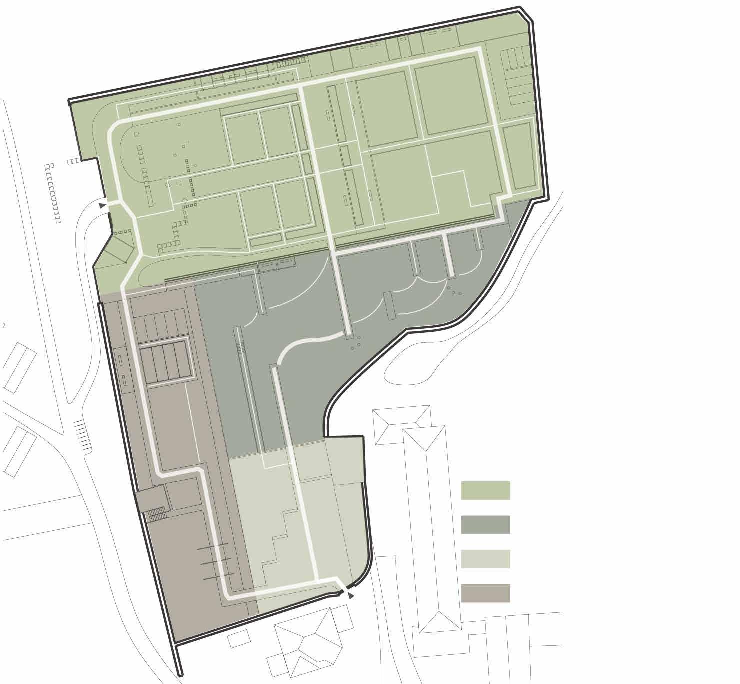
Conceptual Zonning & Path System

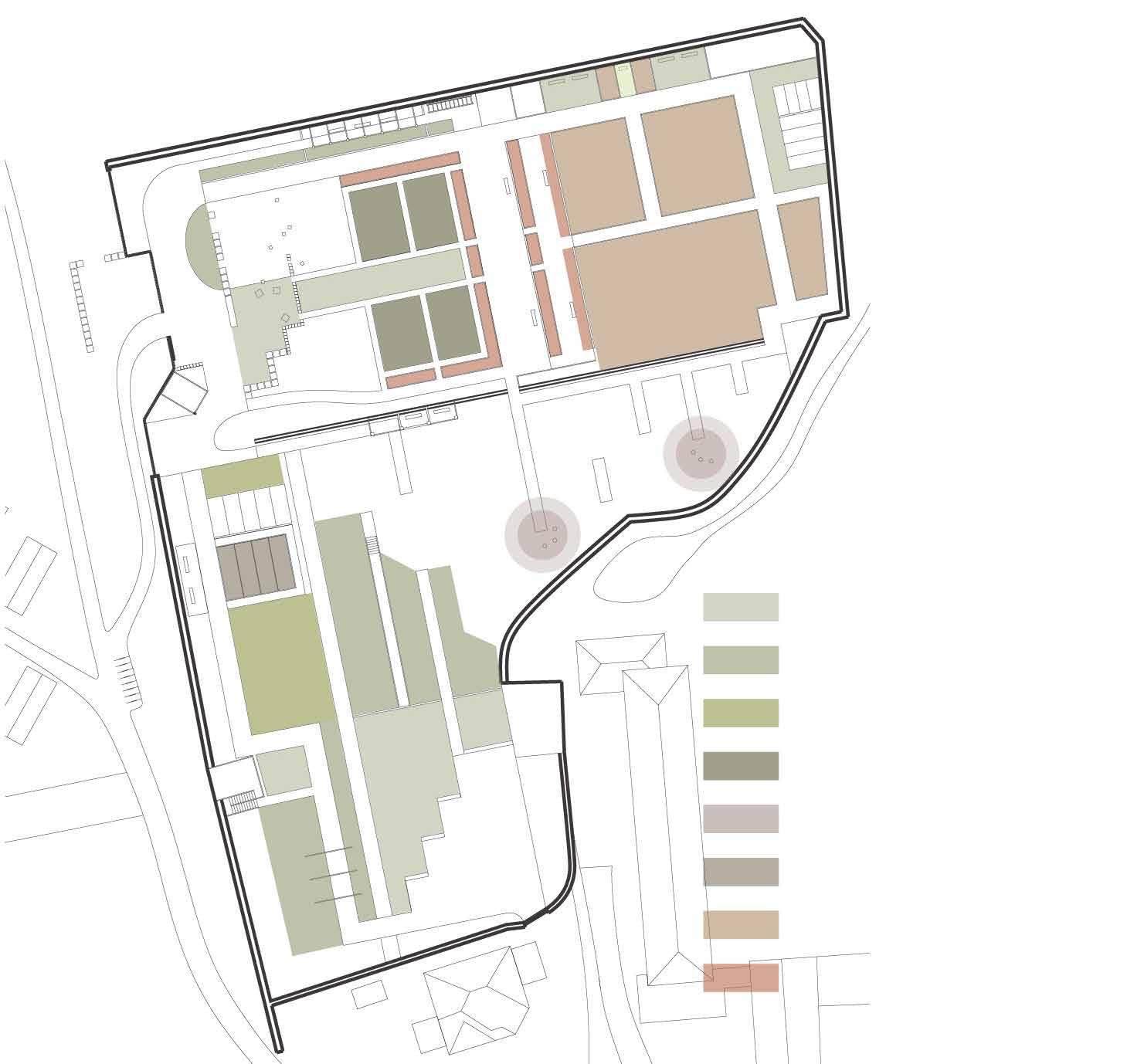
Viewshed & Sightline Guide
Entrance & Historical Zone
Time Tunnel & Meditation Zone
Present Zone
Future Zone
Functional Zonning
Catchment Woodland
Lawn/Meadow
Wild Flower Cultivation
Ochard
Field
Meditation Space
Biomass
Ochard
Planter
Viewshed (Gas Holder)
Sightline (main)
Sightline (sub)
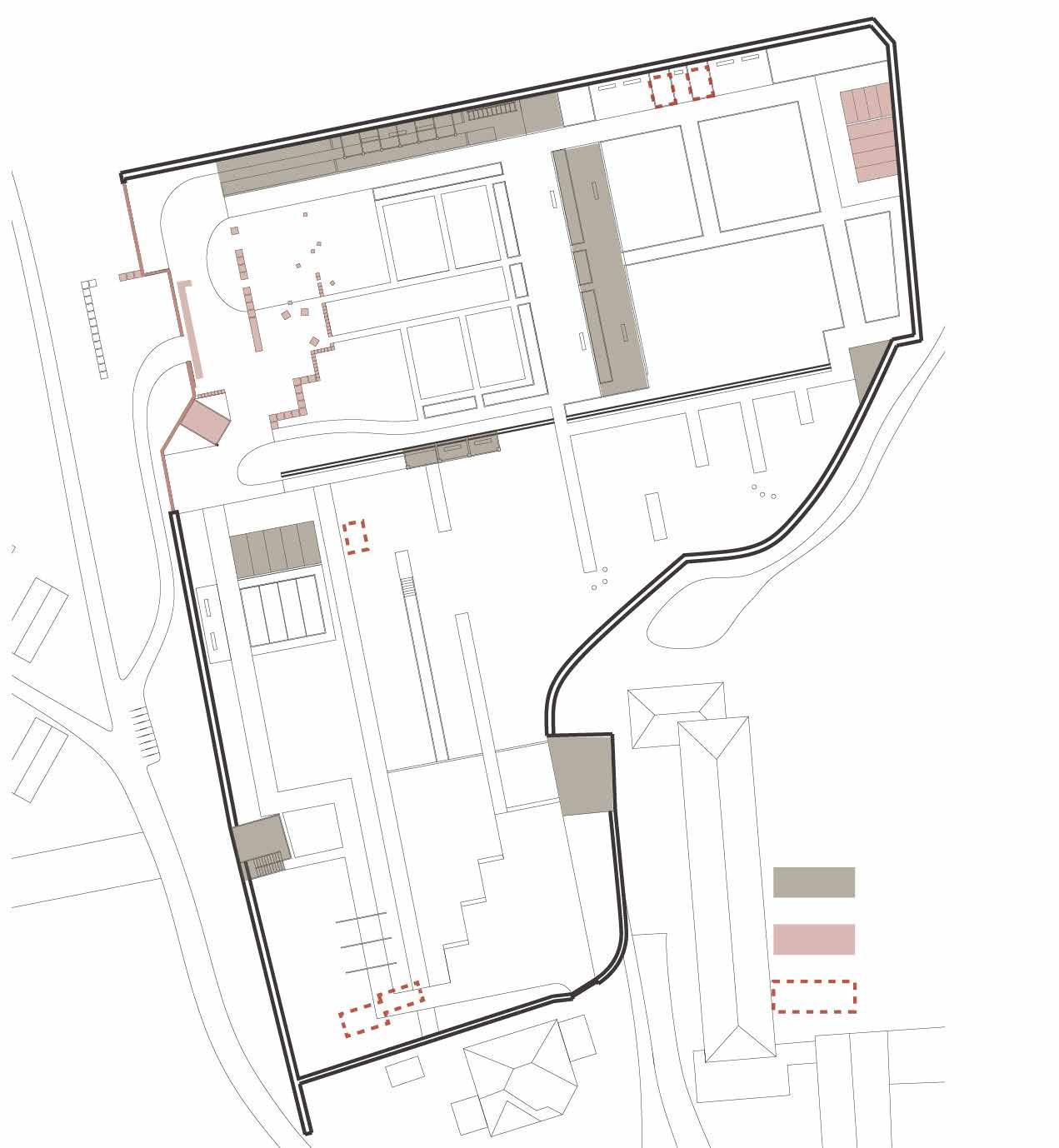
Structures & Facilities
Retained & Renewed
Added
Removed
21
01 ENTRANCE & HISTORICAL ZONE


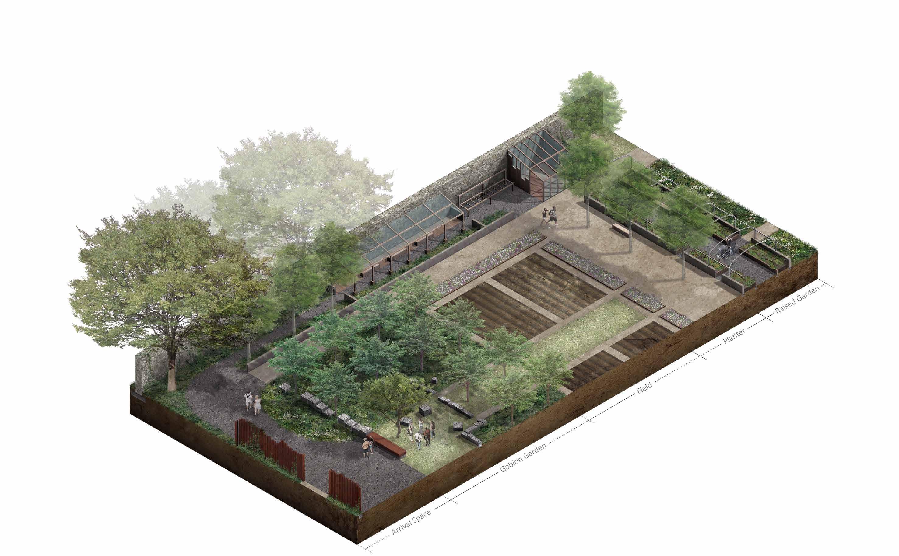
The Historical Zone is mainly designed for agricultural use and education programme. I have designed a new entrance for the garden with an arrival space. Gabion walls is designed to evoke the memory of the demolished castle and introduce the garden’s historical context to visitors. The gabion walls can also use as seats with moveable timber plates. In my design, I used tree grid to draw visitors' attention to the wall, emphasis the west-east direction of the wall, thus guide the movement of visitors. The dye workshop, raised garden and wildflower garden will attract visitors with diverse background to the walled garden.
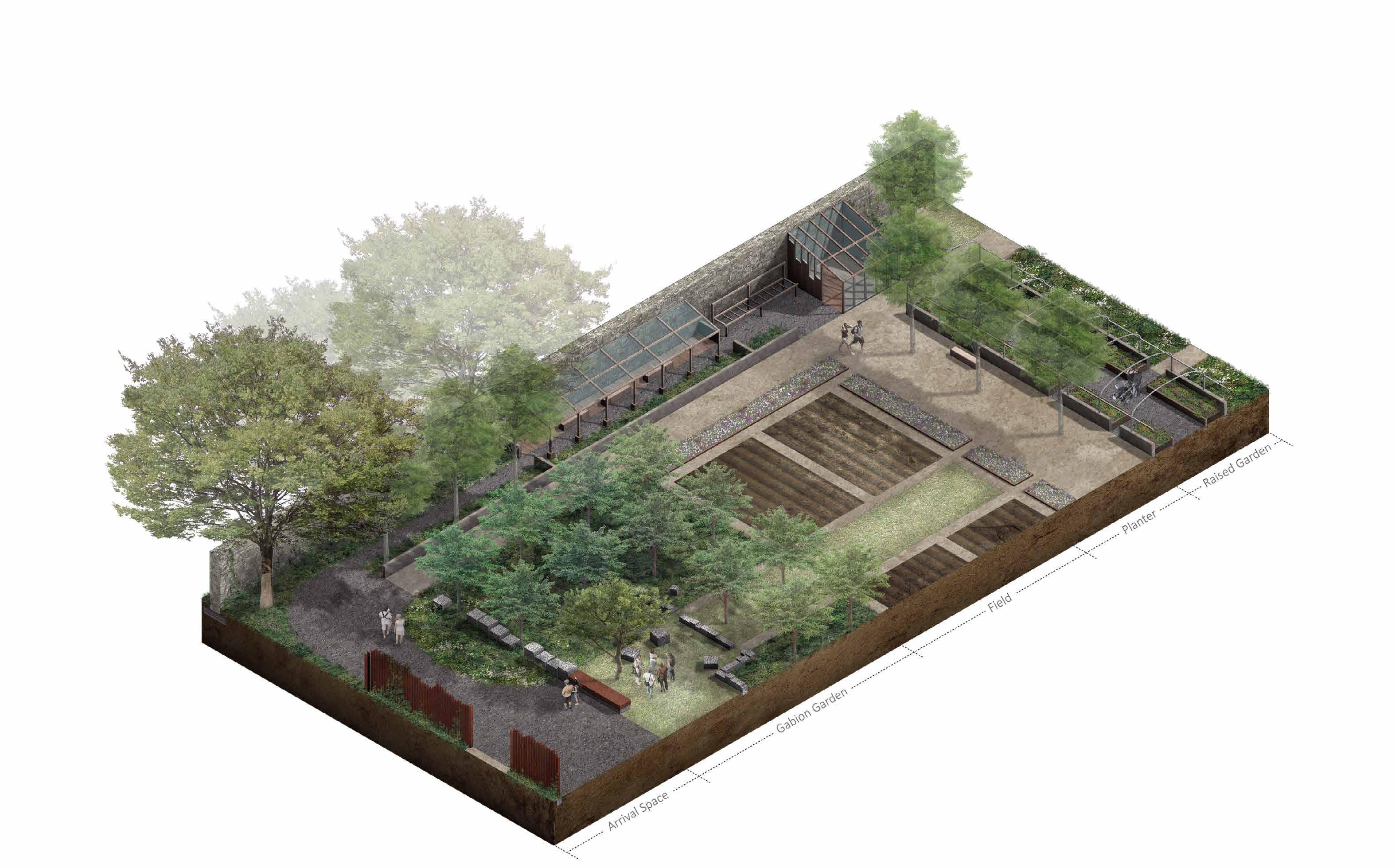

A 0 0.5 2 1 4m
View Corten
View
View Collective Activity Personal Activity Entrance Garden Main Gate Access Road Arrival Space Gabion Garden Crop Field Meditation Sensory Activity Education Gardening Crop Work 2 6 10 Community Service Community Event Fitness Activity
View 1 1 2 3 4 3 2 4
Gabion Memorial-Front
Gate-Front
Gabion Memorial-Side
Gabion Basket-Front
A a 22
02 TIME TUNNEL & MEDITATION ZONE




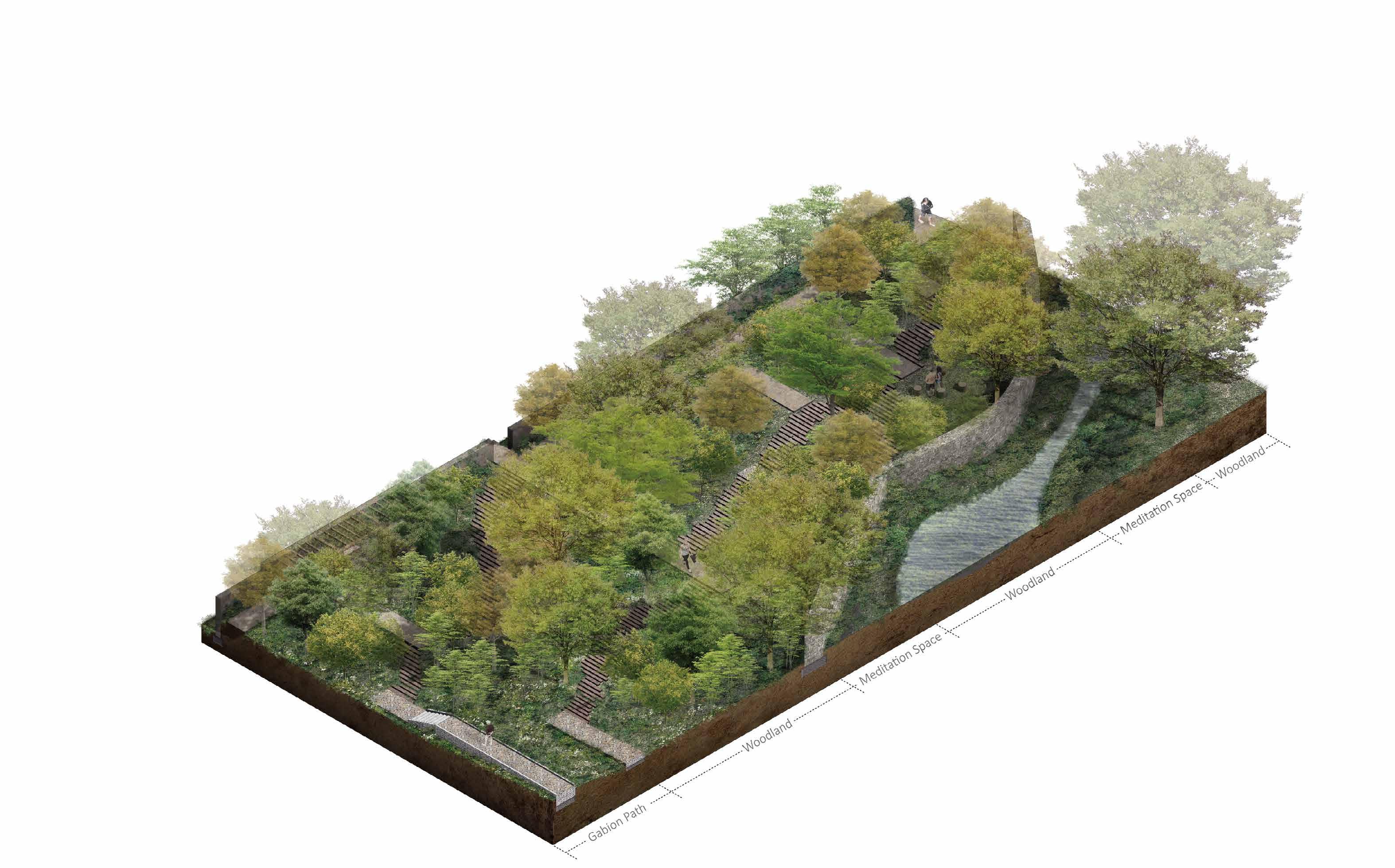
This zone is designed as a transit area between the historical zone and the present zone. Several resting places are designed within the woodland where you can hear the sound from a small creek outside the garden. This zone will provide visitors with meditation area and slows down their speed for getting to the next zone.
In the design, I have kept the existing trees and introduced new trees into the garden, such as birch, ash, Scots Pine, etc. This woodland will create shelters for wildlife in the costal area.

a 0 1 4 2 8m Pergola-Plan View Pergola-Front View Collective Activity Planter & Pathway Raised Garden & Greenhouse Wild Flower Meadow Orchard Wild Flower Meadow Orchard Beehive & Storage Place Personal Activity Meditation Sensory Activity Education Gardening Crop Work 2 6 10 Community Service Community Event Fitness Activity Pergola-Side View 2 1 1 2 3 3
23
03 PRESENT ZONE


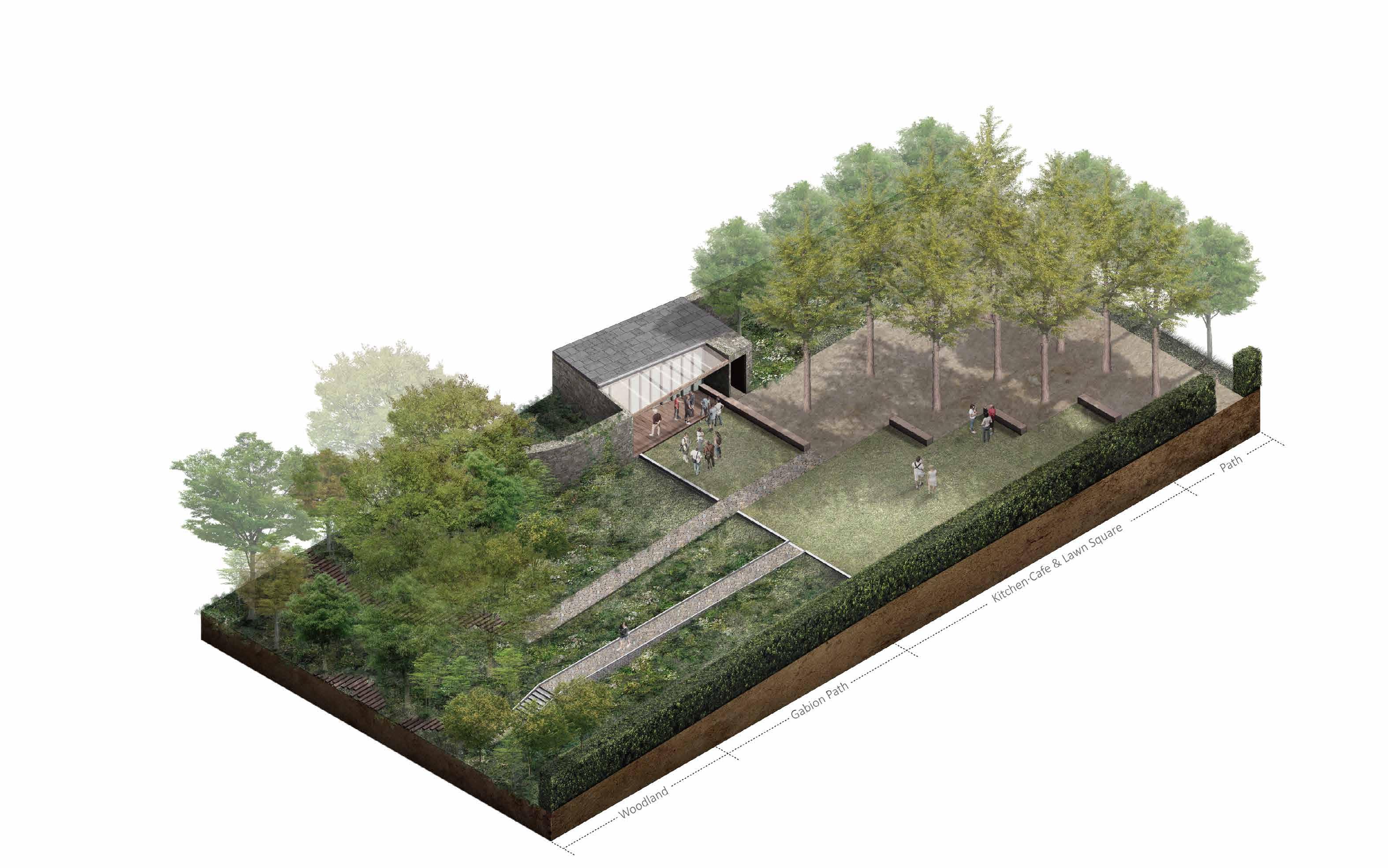
The present zone is designed for holding events and supporting social activities. I have designed a north-south direction gabion pathway to visualize the change of topography in the garden. You can see the sea and the Highland while standing on this pathway. In the design, the storage house is renovated as a local kitchen that can provide food from the garden for community events. This kitchen will create 2-4 jobs for homeless people living in the Social Bite village and provide space for skill education. Spaces within the tree grid can be used for holding kitchen cars and tents during local events.

B 0 1 4 2 8m Kitchen & Cafe-Side View Kitchen & Cafe-Front View B b 1 1 2 2
Collective Activity Personal Activity Meditation Sensory Activity Education Gardening Crop Work 2 6 10 Community Service Community Event Fitness Activity Tree Grid & Bench Meadow Gabion Pathway & Wild Flower Meadow Viewing Platform Pathway 24
04 FUTURE ZONE


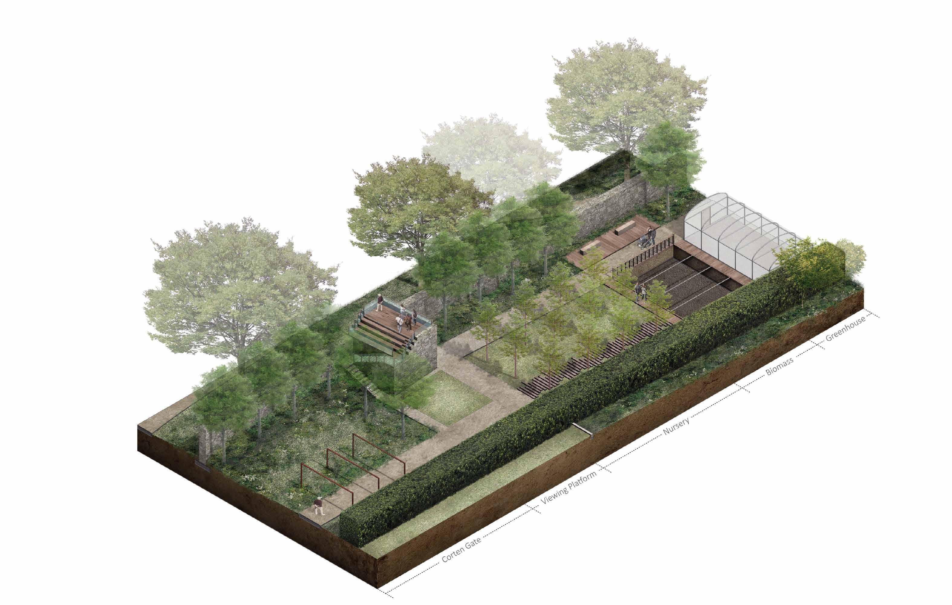
The future zone is designed for educational purpose. This zone has a nursery with biomass that collects food wastes and garden waste to produce compost for the garden. I have also designed a greenhouse beside the biomass which will reuses the compost heat to maintain its temperature. The nursery, as well as the biomass, can be used as nature education spots for the future generations. In my design the doocot is renovated as a viewing platform, providing a place for visitors to overlook both the walled garden and the Firth of Forth.

b 0 1 4 2 8m
Viewing Platform-Side View
1 1 2 2
Viewing Platform-Front View
Collective Activity Personal Activity Meditation Sensory Activity Education Gardening Crop Work 2 6 10 Community Service Community Event Fitness Activity Woodland Pergola Pathway Pathway & Planter Pergola Gabion Garden 25
'Connect' Musselburgh Pump Track Park
INFO Place: Musselburgh, Scotland
Year: 2022
Programme: Landscape Architecture
Ground-Works and Construction Design
The site is located at the edge of Musselburgh Lagoons near the estuary of River Esk. From the early 20th century, it became a place for depositing waste ash from Scottish Power’s coal fired Cockenzie Power Station and gradually formed this artificial landscape stretching 500m out to the Firth of Forth. Although the power station ceased operation in 2013, waste fly ash and construction waste was still send to the Lagoons through pipes.
Much of the 120-hectare lagoon area has already been reclaimed and grassed, trees were planted and created several windbreaks. Nowadays, the Lagoons have attracted various wildlife and became a popular spot for birdwatching.
The existing cycling track covers an area of approximately 0.3-hectare. The track is mainly gravel paved, with steep slopes reinforced by cement. As the track locates at the toe of the ash slopes, part of the site often become waterlog during wet-weather, and some areas are at high risk of surface water flooding.
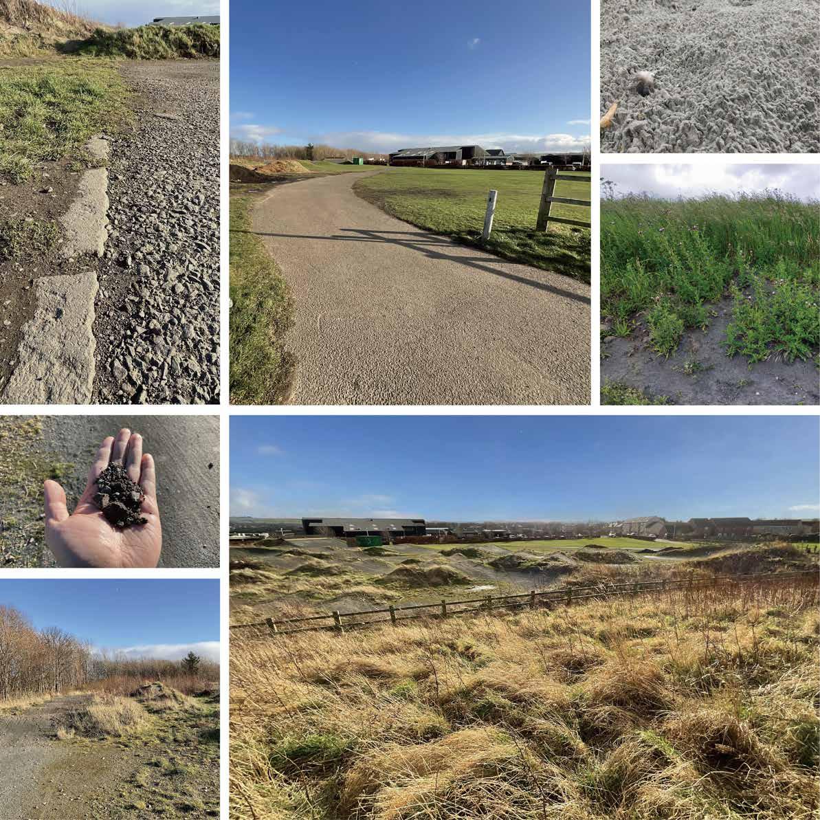
The southern part of my site is a meadow that used as a temporary car park for the Musselburgh Race Course. A road that connects lagoon area and the town centre form the western boundary of the site. Many visitors use this open space for dog walking or as a transit point to reach lagoon area.
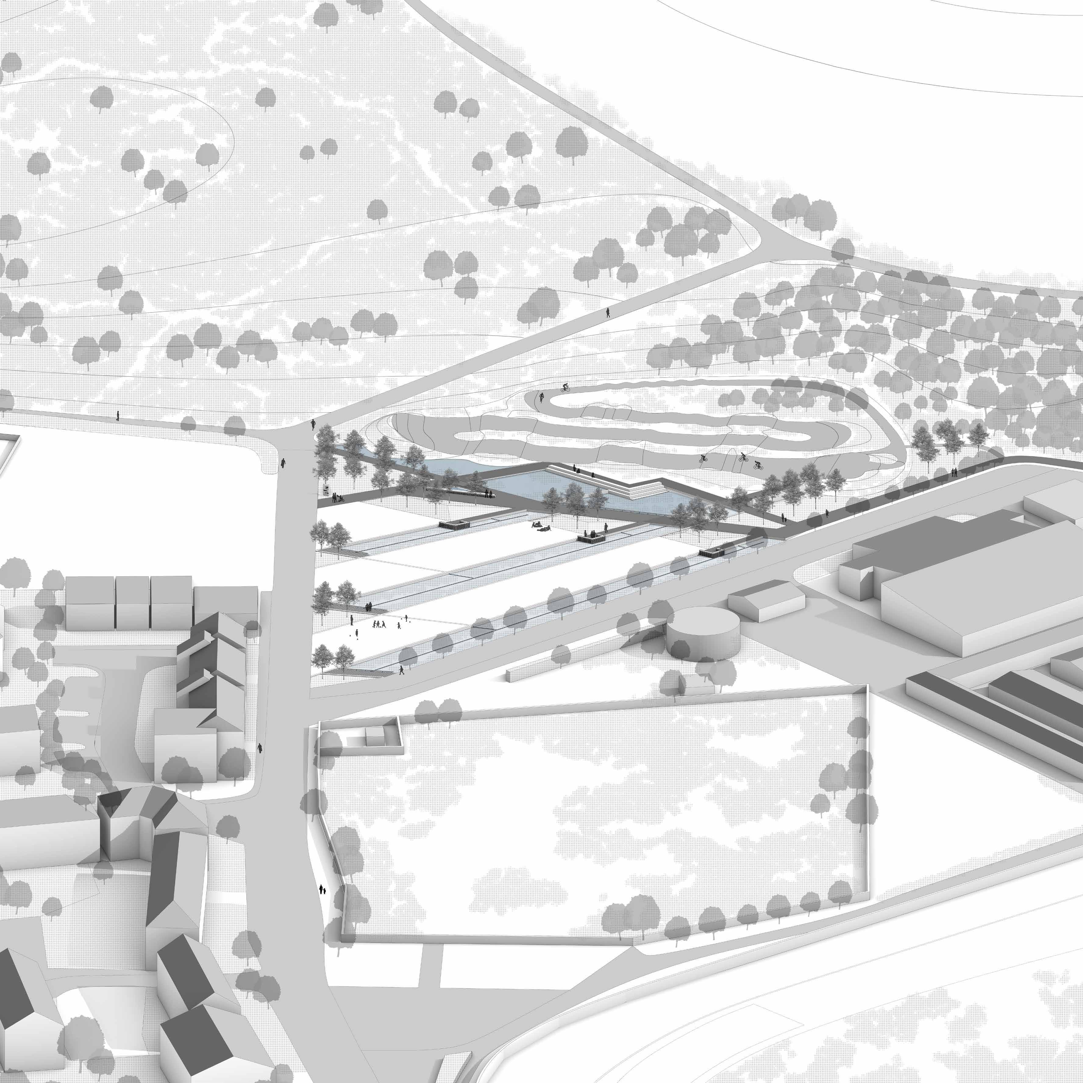
The 3 main purposes of my design are to solve the flooding issue of the cycle track, create multi functional public space for both cyclists and general visitors, and create diverse habitats for wildlife living in the lagoon area. My design also aims to reduce the flooding risk at the estuary area and create green corridors that connect the city with the lagoons and water front.
1 2 3 4 7 5 6
03.
1.Boundary of the town and Ash Lagoons 2.Site Entrance 3.Ash exposed on the ground 4.Thistle growing on the ash 5.Cement fragment from the track 6.Track and the woodland 7.Track and the meadow
27
PUMP TRACK PARK MASTER PLAN


1.River Esk 2.Musselburgh Lagoons 3.Cycling Track 4.Musselburgh
5.Golf Course 0 1 10 5 20m N Scale: 1/200@A0 2 1 7 4 5 10 11 12 6 8 13 14 3 9 3 1 2 4 5 LEGEND 1 Cycling Track 2 Starting Gate 3 Park Sign Stone 4 Galvanized Steel Walkway 5 Concrete Bench 6 Bike Stand 7 Water Pump 8 Gabion Bench 9 Wood Deck 10 Windbreak 11 Rain Garden #1 12 Rain Garden #2 13 Ground Gutter 14 Sunken Green Space
28
Racecourse
Existing Conditions & Proposed Landscape




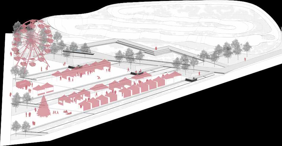

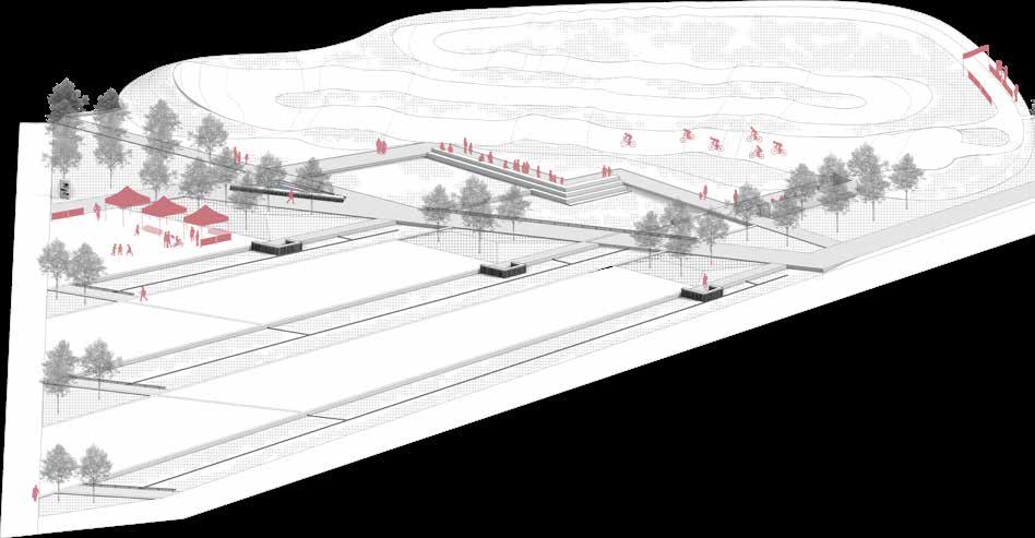
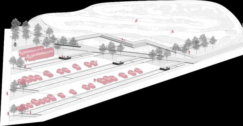
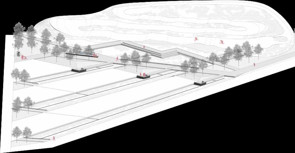
Activities In Pump Track Park

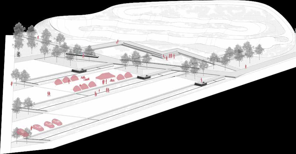
Daily activation Local cycling event Car park for horse racing Daily activation - rainfall Yoga in the meadow Holiday activation Daily activation - storm Summer camp Movie night
Underground tank Meadow Meadow Woodland Cycling track Rain garden Sunken Meadow Cycling track Main path Sunken green space Windbreak/Woodland Road system Access roads Pipe/Ground gutter/Inlet Surface Runoff Rain garden Desire Path Focal point Path N Existing Condition Vegetation Stormwater Management Pathway System 29
Detailed Design


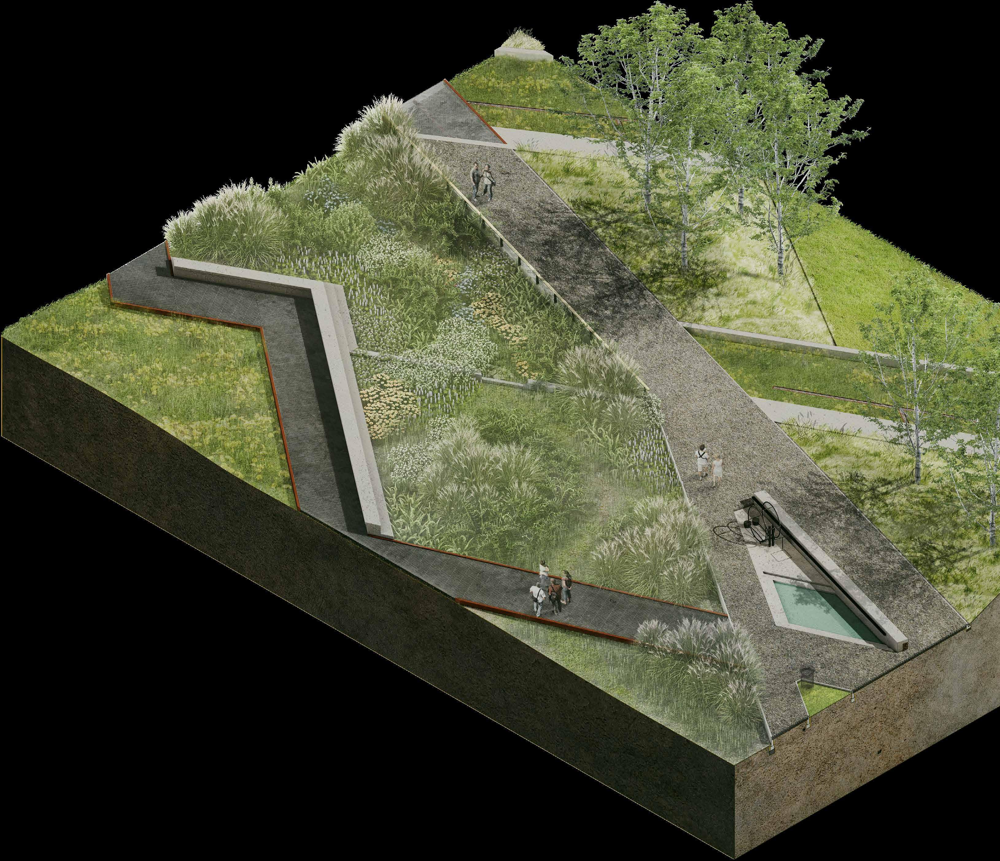
At the stage of detailed design I analysed how the park will be used by cyclists, general visitors and wildlife and tried to meet their needs. As the main theme of the park will be sports, I prioritized hard materials with high durability and lowmaintenance needs. I also designed replaceable furniture and structures to facilitate maintenance work. At the stage of soft material selection, I also chose plants with low-maintenance needs. The majority of the park's ground cover will consist of lawns and wildflower meadows using seed mix from Scotia Seeds
1 2 3 6 7 8 4 5
1.Galvanized Steel Walkway
2. Concrete Seat
3. Stone Weir
4. Windbreak Slope
5. Ground Gutter
6. Foot Water Pump
7. Sunken Pond
8. Concrete Seat
9. Gabion Seat
30
Cyclist Visitor Wildlife
Wildlife & Habitats
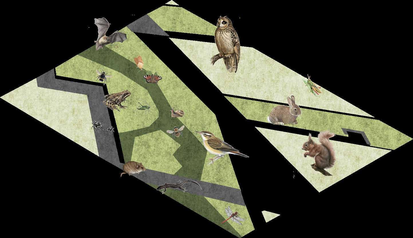
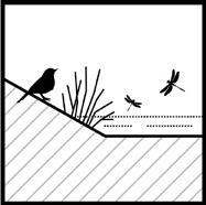
The Musselburgh Lagoons are valuable habitats for birds, and the salt marsh around the estuary provides places for various organisms to feed and live. As most of the soil in the lagoons comes from waste ash from power plants, its soil conditions are not suitable for small animals and insects. In my project I introduced a variety of perennials and trees and used topsoil from the construction process to improve the existing soils conditions which provide better habitat for the wildlife.
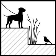
The change in elevation will reduce the impart of dogs on wildlife
Structures and plants will provide diverse shelters for wildlife

Rainwater Management
The garden will attract multiple wildlife species through diverse habitats

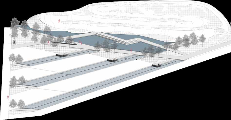
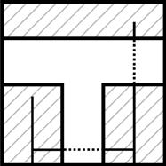
On normal days only the rain garden located at the centre of the park will remain wet. During a rainstorm the water will first fill the rain garden, followed by the bioswale that connect with the garden and finally the sunken green space in the southern part of the park. Any rainwater that exceeds the capacity of the park will be discharged into the sea through pipes.
The weir structures will slow surface runoff wihile promote water infiltration
Ground gutters and pipe lines will help to keep the balance of stormwater in sunken greenspaces and provide corridors for small animals
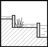
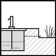
The underground tank will enhance the park's capacity for heavy rainfall and hold the water for daily use


Nightlife
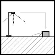
Due to the remote location of the park, only a small number of users are expected to visit at night. Therefore, I have only designed built-in lighting on main furnitures and some of the guard rails to provide a minimum of illumination to reduce light pollution while ensuring the safety of the park.
Lighting systems at lower heights will reduce the imapct of lights on wildlife
Furniture built-in lights will help reduce the need for individual lighting facilities
Linear lighting will guide the movement of users at night, and enhance the spatial experience


1 2 3 1 15 8 5 6 1 4 10 9 16 12 11 7 17 3 13 14 2 3 4 2 9 N Damp Area Underground stormwater storage LED Spotlights Wet Area Stormwater from neighbours LED Strip Lights (Concrete Seat) Dry Area Rain garden Structures Shady Area Surface runoff from the pump track LED Strip Lights (Gabion Seat) Heavy Rainfall Lighting Wildlife Habitats 1 2 3 4 1 2 3
1 Grove Snail
2
Bush Cricket
3
Grasshopper
4
Zebra Spider
5
Light Brown Apple Moth
7
8
9 Honeybee 10 Common Frog 11 Common Lizard 12 Field Vole 13 Wild Rabbit 14 Red Squirrel 15 Soprano Pipistrelle Bat 16 Sedge Warbler 17 Short Eared Owls 31
6 Peacock Butterfly
Common Darter
Bumblebee
Proposed Section
1. Galvanized steel walkway
2. Rain garden side walkway
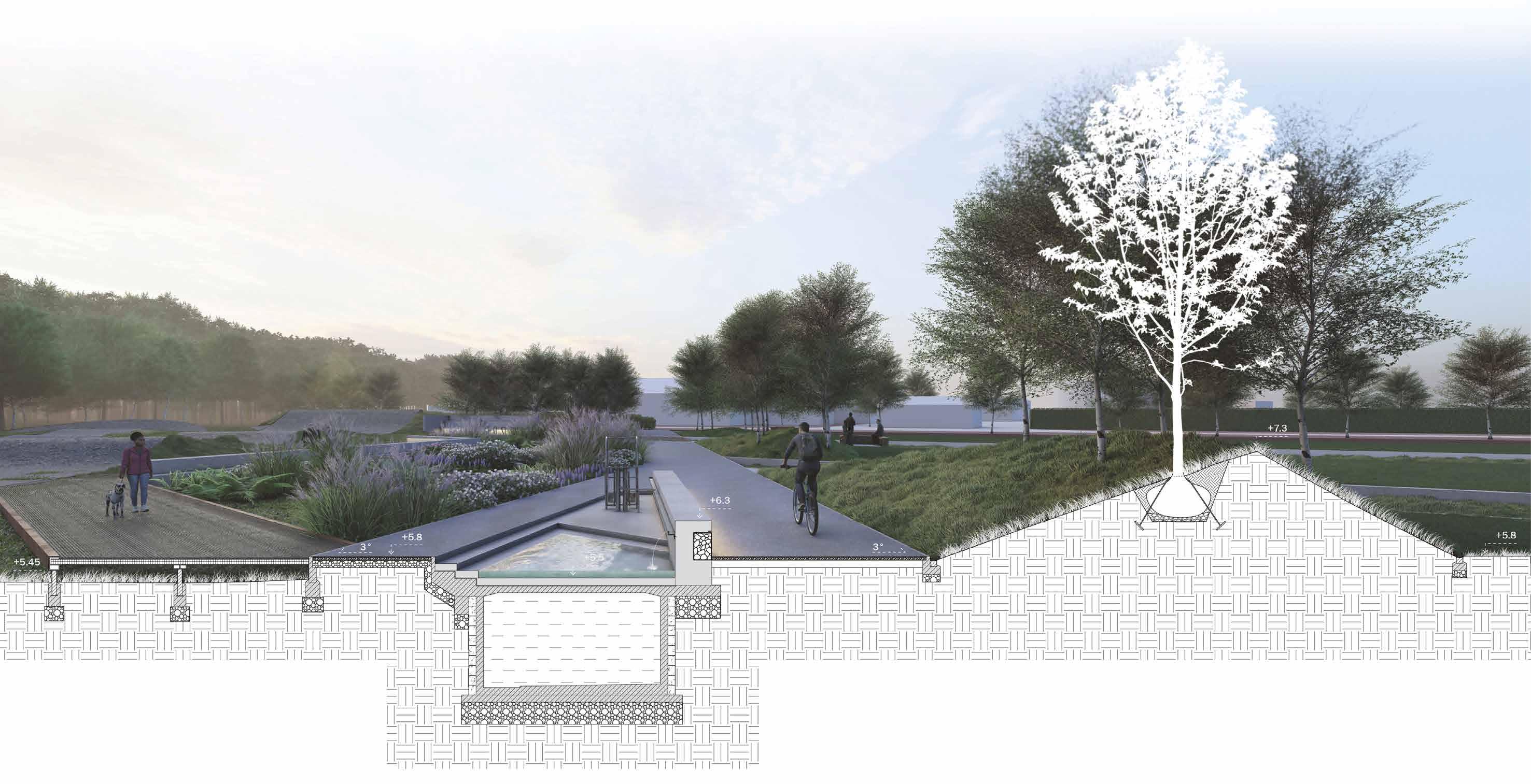
3. Underground water tank
4. Gabion wall with strip light
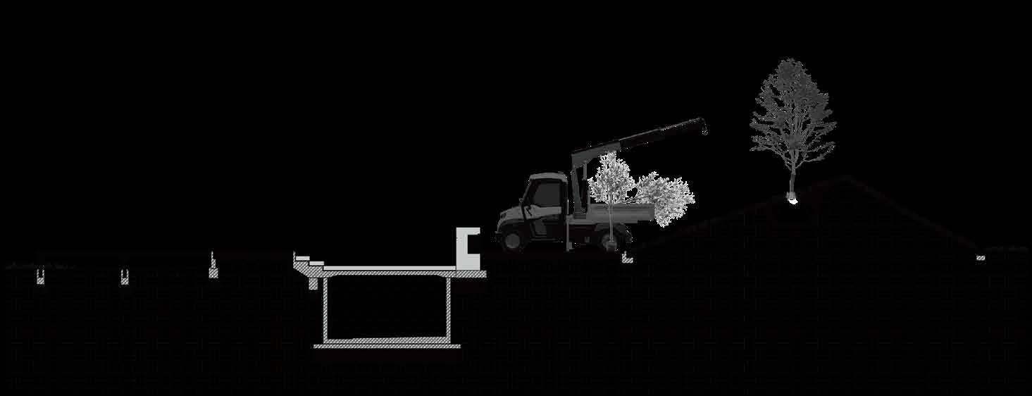
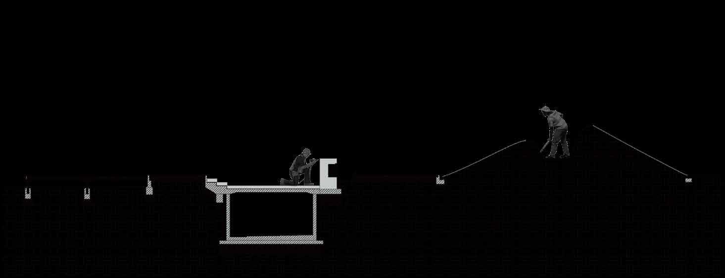
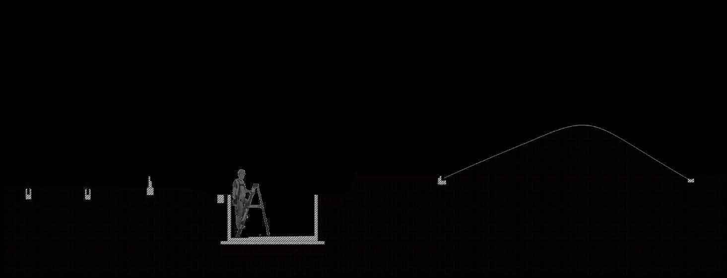
Construction Sequence

5. Main path
6. Drainage channel
7. Windbreak slope (tree)
8. Drainage channel
0 0.5 2 1 4m 1 2 3 4 5 6 7 8
1
Phase
Phase 3
Phase 2
Phase 4
Pit prepared for the track-side deck foundations. Pit prepared for the track-side deck foundations. Foundations for the trackside deck. Remove mud and dust from the sunken platform. Part of the roadbed need to be removed for the construction of the underground water tank. Due to the need to install gabion walls, part of the road will be paved at the end of the construction. Foundations for the water tank, concrete seat, gabion wall and steps. Use mini crane to assist the planting of windbreaks. Use of soil cover net to prevent erosion on slopes. Digging pits for the planting of windbreaks. Install the drainage channel. Use of soil cover net to prevent erosion on slopes. 32
11. Pervious concrete, 50mm
12. Sub-base DTp1, 100-150mm
13. Drainage pipe, R=60mm
14. Concrete foundation
15. Concrete masonry unit, 100x100x250mm
16. Geotextile
17. Conctete wall, 100mm
18. Concrete block step, 100x300mm
19. Mortar bed, 10mm
20. Steel gutter, 50x100x1000mm, 5mm
21. Gabion with sandstone
22. Sub-base DTp1, 300mm
Galvanized Steel Walkway
1. Round pipe, 330x5mm R=65mm
2. U molding corten steel, 150x200mm, 5mm
3. Galvanized grating, 500x3000x70mm, 5mm
4. U molding nonalloy, 180x70, 5mm
5. Concrete foundation
Construction Design

6. Sub-base DTp1, 200mm
7. Steel base plate, 5mm
8. Concrete palisade
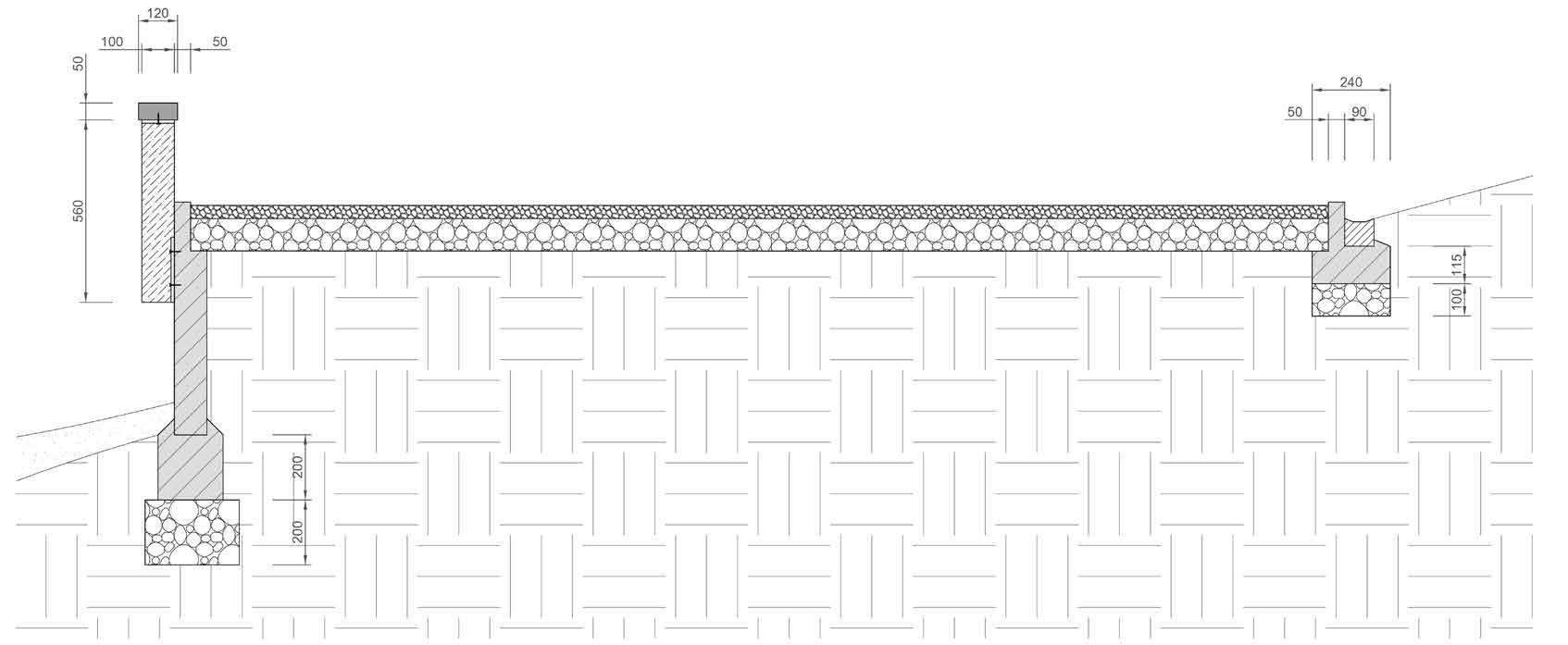
9. Sub-base DTp1, 200mm
10. Subsoil
34. Pressure treated timber, 120x50x1500mm
35. Flat steel picket, 560x100x10mm
36. Pervious concrete, 50mm
37. Sub-base DTp1, 150mm
38. Subsoil
39. Concrete palisade
40. Concrete foundation
41. Sub-base DTp1, 200mm
42. Concrete kerb
43. Sub-base DTp1, 100mm
44. Precast concrete water channel
Drainage Channel &
23. Concrete foundation
24. LED strip light, 9w/mx12m (8x16mm warm white, IP Rating 65)
25. Fair-faced concrete bench
26. Sub-base DTp1, 100mm
27. Pervious concrete, 50mm
28. Precast concrete water channel
29. Sub-base DTp1, 100mm
30. Anchor
31. Coarse gravel
32. Backfill soil
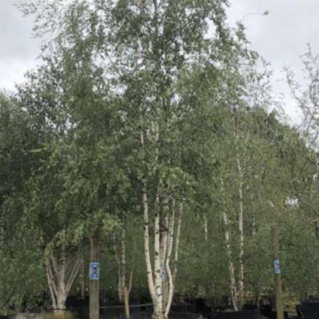
33. Betula pubescens
1 26 27 28 29 30 31 32 33 2 3 4 5 6 7 8 9 10 11 12 13 14 15 16 17 18 19 20 21 22 23 24 25 38 37 36 35 34 39 40 41 42 43 44
Path & Guard Rail
Main
Windbreak Underground Water Tank & Gabion Seat
33
A Structures & Furniture
A. Water Pump & Underground tank
I have designed an underground tank beside the rain garden to help to achieve sustainable rainwater management. I also designed a sunken platform over the tank with a manual pump for pumping water, so that vistiors can use these water for washsing their bike or shoes after exploring the muddy landscape of Ash Lagoons. Concrete bench helps to separate the water area from the main path, while parents can also sit here to accompany children playing with the water.
C. Gabion Seat
The gabion seats near the intersection of the main path and meadows provide visitors with seating space. The U-shaped structure allows it to be used for small gatherings, while the gabion wall at the edge of the sunken green spaces provides shelters for small animals and insects.
B. Galvanised Steel Walkway
Considering the use by cyclists, I selected this galvanized grating deck for the trackside access, It's high friction surface will allow bicycles to pass safely. This material will also reduce the impact of the hard paving on the site's permeability and create shade for wildlife.
A. Water Pump & Underground tank
1. Water pump: The round pedal can be driven to pump water by stepping up and down, this is more efficient and hygienic than using the pump by hands.
2. Concrete masonry unit: This structure is designed to reinforce the wall of the underground water tank. Geotextile layer is added between the wall and the tank to reinforce the structure.
3. Rainwater inlet: that allows water to flow into the tank from the rain garden .
4. Foundation: A 100mm thick concrete foundation and 300mm of DTp1 is the foundation of the water tank.
5. Tank access port: A 650x650mm access port is designed for routine maintenance of the underground tank.

6. Mesh fulter: The inlet of the pump is equipt with metal mesh to prevent clogging with sediments and fallen leaves.
7. Metal pipe: The pipe leads the pumped up water into the sunken platform.

8. Gabion wall and bench: The gabion wall is embed in the concrete bench. Strip LED lights were added to the bench for minimal lighting.
9. Water Outlet: Rainwater that exceeds the tank's capacity will discharged into the sea via pipes.
1 5 2 3 4 6 9 8 7
34


10 12 13 11 14 15 17 16 18 19
10. Galvanized grating unit: 500x3000x70mm, 5mm this high friction surface will help to remove the mud from wheels.
11. Fixing rail: The u-frame corten steel for fixing the Galvanized grating unit can be changed to other shapes materials as required. This structure also allows workers to easily replace the deck as needed.
12. Supporting rail: 180x70mm, 5mm, This rail will help 2 fixing rails to support the highly used deck.
13. Deck pillar: The deck is supported by only a small number of pillars, thus reducing the impact of the paving on the permeability of the ground.
14. Wood board: Red Cedar, This material is durable and strong.
15. Wooden frame: This structure will help to fix the gabion wall and support wood boards for seating.
16. Stone filler: Sandstone, Stones will provide shelters for small wildlife appear in the sunken green space.
17. Gabion basket: 600X1000X300mm, Galfan Coated Steel
18. Concrete foundation: 200mm, the C-shaped structure will keep gabion baskets from shifting.
B C
19. Gravel foundation: 300mm Sub-base DTp1
B. Galvanised Steel Walkway
35
C. Gabion Seat
Planting Scheme
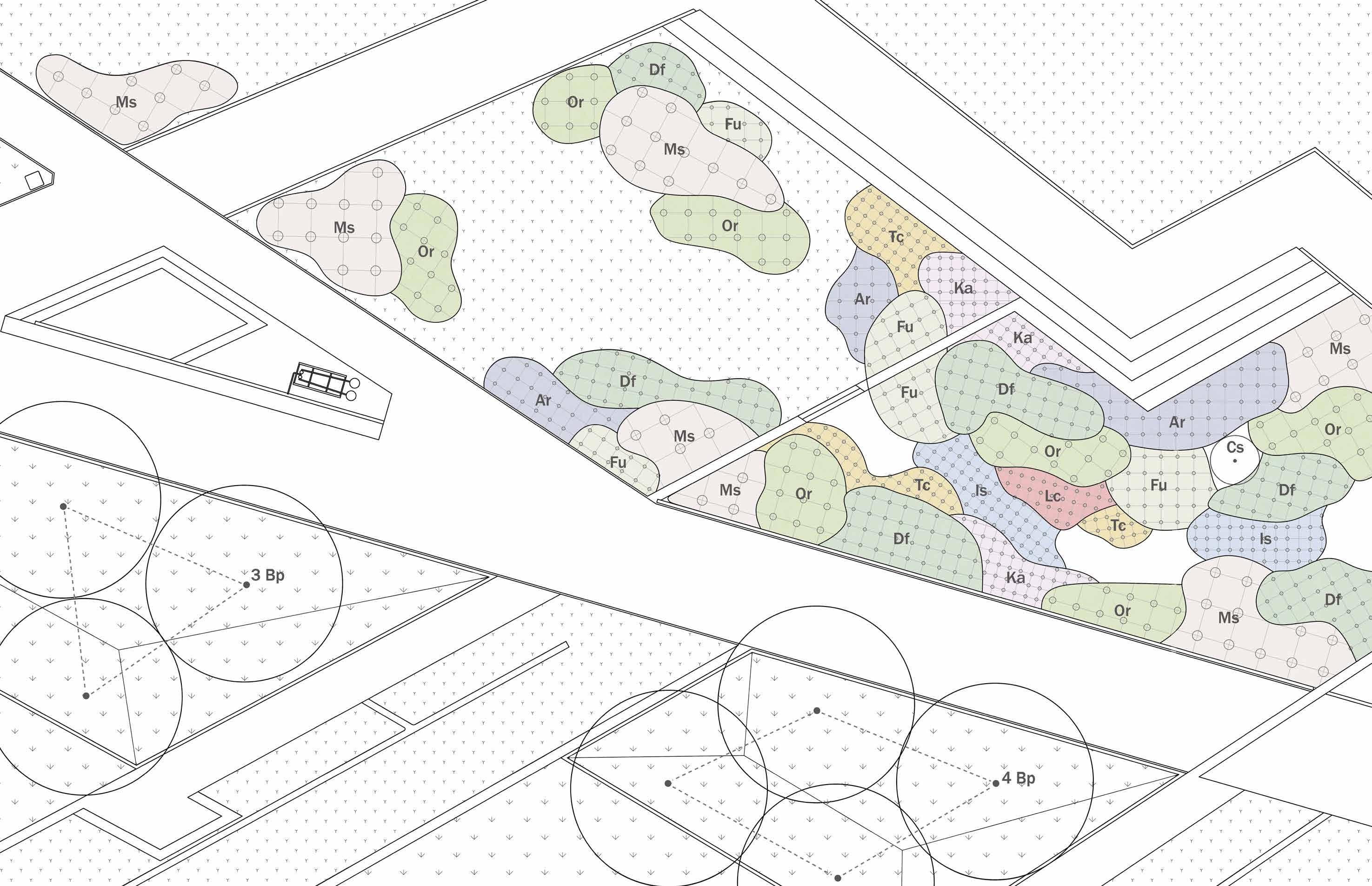
Proposed Vegetation Section

Or Ka Is Tc Ms Df Ar
36
Garden & Windbreak Plant List
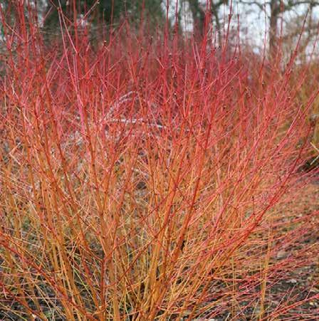

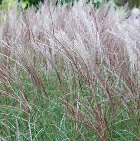
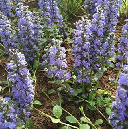

JAN FEB MAR APR MAY JUN JUL AUG SEP OCT NOV DEC
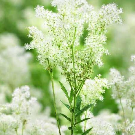
Betula pubescens Ajuga reptans Filipendula ulmaria
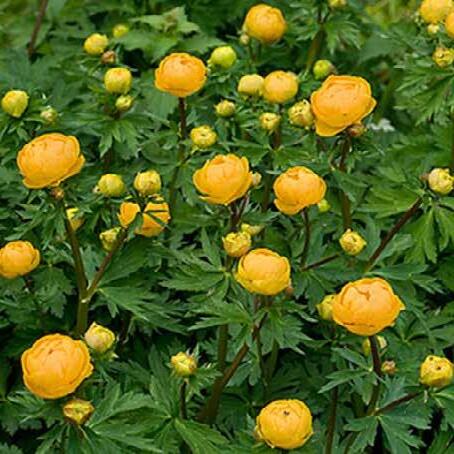
Trollius × cultorum ‘Orange Princess’
Lobelia cardinalis
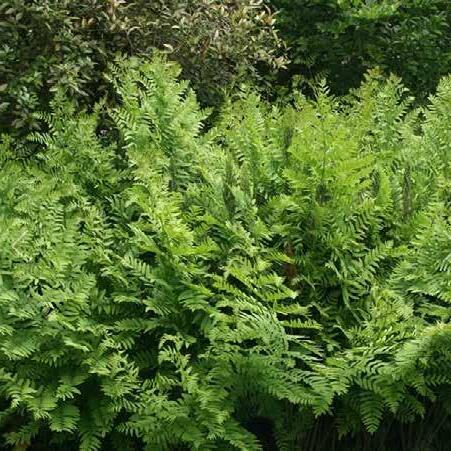
Osmunda regalis Iris sibirica
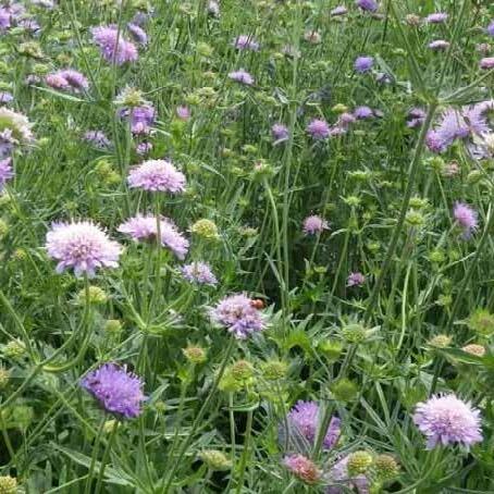
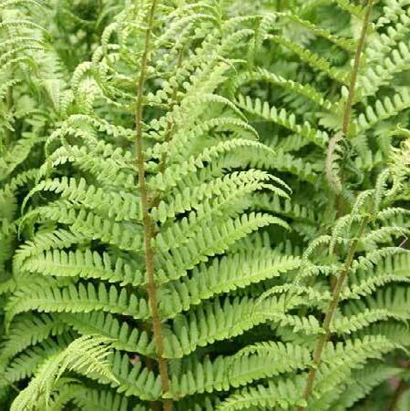
Latin name Common name Sunlight Moisture Ultimate height/m Ultimate spread/m Haediness Tree Bp Betula pubescens Downy birch Full sun/Partial shade Moist but well–drained/ Well–drained 12 4-8 H7 Shrubs Cs Cornus sanguinea Common dogwood Full sun/Partial shade Moist but well–drained/ Well–drained 1.5-2.5 1.5-2.5 H6 Flowering herbaceous perennials Ar Ajuga reptans Bugle Partial shade Moist but well–drained/ Poorly–drained 0.1-0.5 0.5-0.1 H7 Ka Knautia arvensis Field scabious Full sun Well–drained 1-1.5 0.1-0.5 H7 Fu Filipendula ulmaria Meadowsweet Full sun/Partial shade Moist but well–drained/ Poorly–drained 0.5-1 0.5-1 H6 Tc Trollius × cultorum 'Orange Princess' Globeflower Full sun/Partial shade Poorly–drained 0.5-1 0.1-0.5 H7 Is Iris sibirica Siberian flag Full sun/Partial shade Moist but well–drained 1-1.5 0.1-0.5 H7 Lc Lobelia cardinalis Cardinal flower Full sun/Partial shade Poorly–drained 0.5-1 0.1-0.5 H3 Ferns Df Dryopteris filix-mas Male fern Full shade/Partial shade Moist but well–drained/ Poorly–drained 1-1.5 0.5-1 H7 Or Osmunda regalis Royal fern Full sun/Full shade/Partial shade Moist but well–drained/ Poorly–drained 1.5-2.5 0.5-1 H6 Sedges Ms Miscanthus sinensis Eulalia Full sun Moist but well–drained/ Well–drained 2.5-4 1-1.5 H6 Betula pubescens Ajuga reptans Filipendula ulmaria Trollius × cultorum ‘Orange Princess’ Lobelia cardinalis Osmunda regalis Iris sibirica Dryopteris filix-mas Miscanthus sinensis Cornus sanguinea Knautia arvensis
Dryopteris filix-mas
Miscanthus
sinensis
Cornus sanguinea Knautia arvensis
37
Selected Extras Undergraduate Projects
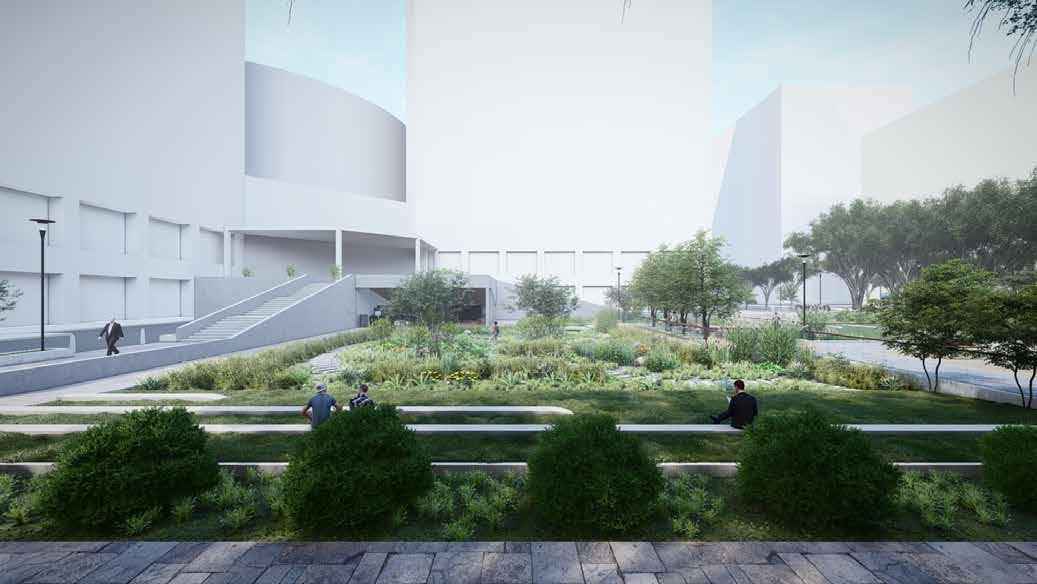
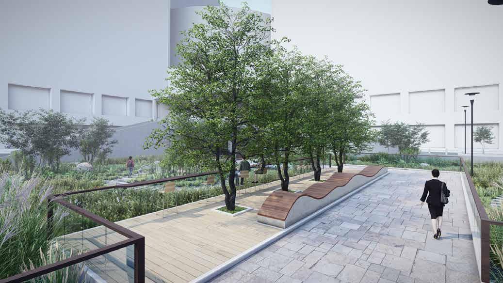
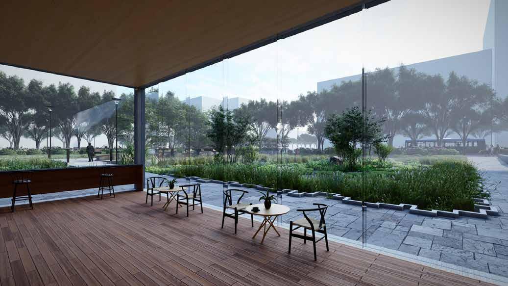
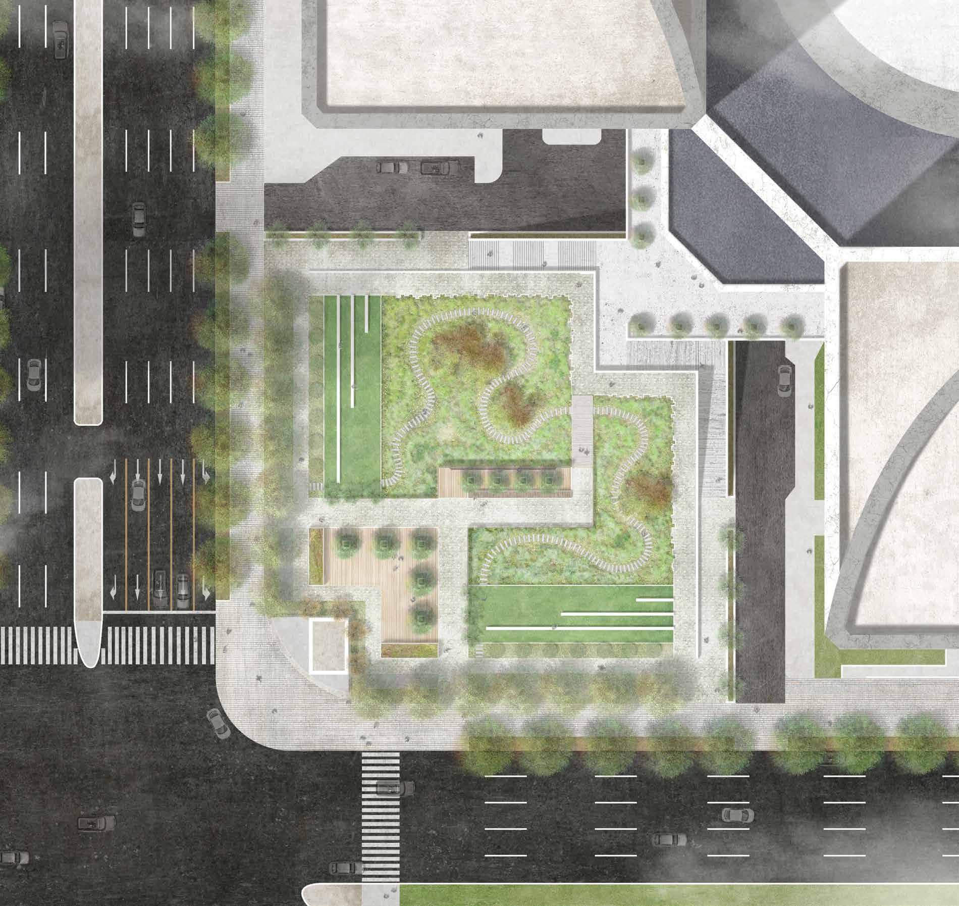
INFO Place: Harumi, Tokyo, Japan
Year: 2020
Type: Urban public space & Rain garden
N
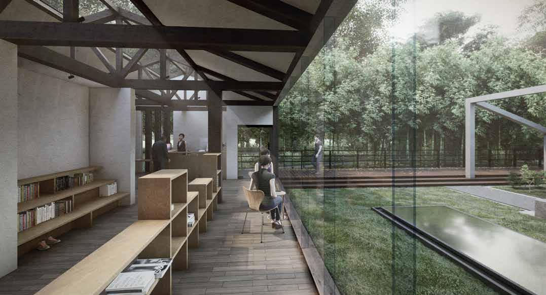
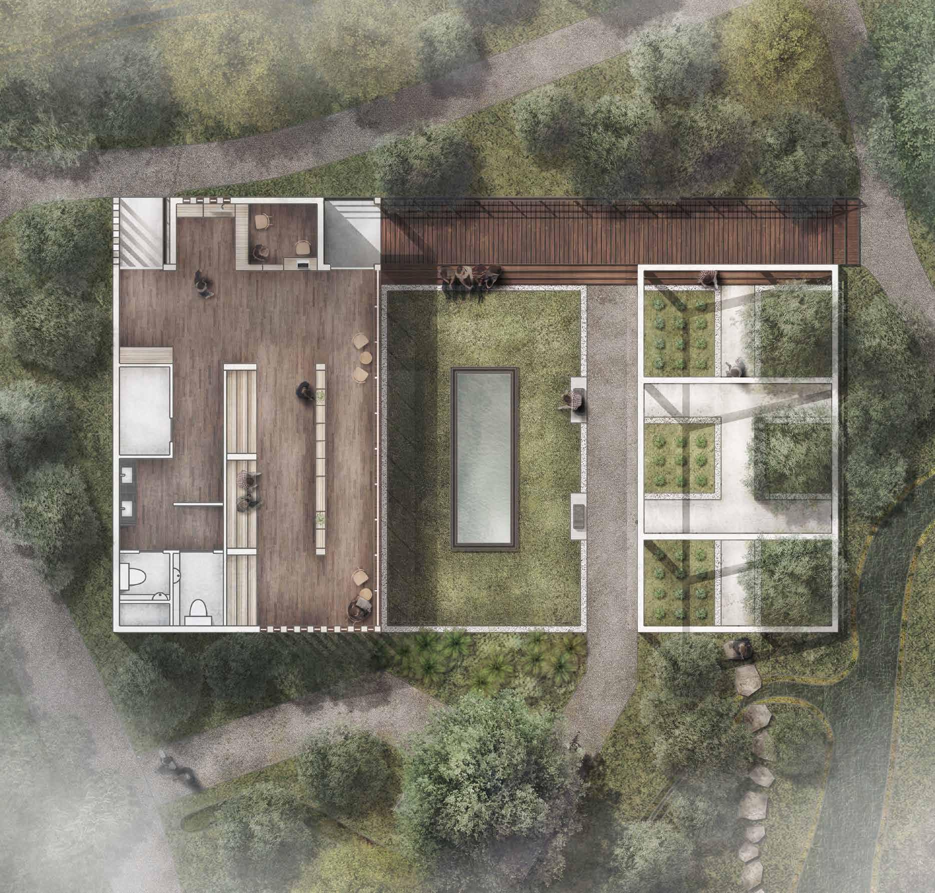
INFO Place: Setagaya, Tokyo, Japan
Year: 2021

Type: Information centre of Kyu-Kosaka Park

N
Edinburgh +44 7536121406
bunkishin@gmail.com

 MLA PROJECTS / 2021-2023


