This section presents the recommended goals, objectives and policies for the Carlsbad Pedestrian Master Plan. The goals and objectives provide the long-term vision and serve as the foundation of the plan, while the policies provide more specific descriptions of actions to undertake to implement the plan.
As part of the Pedestrian Master Plan, the goals, objectives and implementing policies of the existing 2004 General Plan
Circulation and Land Use Elements have been expanded upon to provide an updated and comprehensive set of goals, objectives and policies covering Streets and Traffic Control, Alternative Modes of Transportation, Overall Land Use Policies, Residential Land Uses, Commercial Land Uses and the Village. Goals, objectives and policies shown in italics are taken directly from these existing General Plan Circulation and Land Use Elements.
3.1 Streets and Traffic Control
3.1.1
Goals
Goal 1. A City with inviting streetscapes that encourage walking and promote a sense of neighborhoods in residential developments. ( Street and Traffic Control Goal A.5)
Goal 2. A City with streets designed to balance vehicular requirements with the needs of all pedestrians including children, the elderly and the disabled. (Street and Traffic Control Goal A.6)
Goal 3. A City with a circulation system that promotes alternative transportation such as walking, bicycling and public transportation. (Street and Traffic Control Goal A.8)
3.1.2
Objectives
Objective 1. To design streets for the safe and efficient movement of people, goods and services in the most environmentally sound manner possible. (Street and Traffic Control Objective B.2)
Objective 2. To design new subdivisions with streets where trees, parkways and traffic calming measures beautify neighborhoods, slow vehicle speeds, maintain on-street parking and encourage residents to walk or bicycle. (Street and Traffic Control Objective B.8)
3.1.3 Implementing Policies
Policy 1. Require new subdivisions to provide walkways linking homes with stores, schools, businesses and transportation corridors, etc. (Street and Traffic Control Implementing Policy C.20)
Policy 2. Require new subdivisions to incorporate parkways to encourage pedestrian activity. (Street and Traffic Control Implementing Policy C.21)
Policy 3. Require residential subdivisions to provide street connectivity to the maximum extent feasible by limiting the use of single access streets. (Street and Traffic Control Implementing Policy C.22)
3.2 Alternative Modes of Travel
3.2.1 Goals
Goal 1. A City which promotes, encourages, and accommodates a variety of transportation modes as alternatives to the automobile. (Alternative Modes of Transportation Goal A)
3.2.2 Objectives
Objective 1. To provide infrastructure and facilities necessary to accommodate pedestrians, bicycles, and other nonautomobile modes of transportation. (Alternative Modes of Transportation Objective B.1)
Objective 2. To reduce the number and severity of vehicular, bicycle and pedestrian-related accidents. (Alternative Modes of Transportation Objective B.2)
Objective 3. To prioritize future sidewalk construction. (Alternative Modes of Transportation Objective B.3)
3.2.3 Implementing Policies
Policy 1. Encourage the construction of sidewalks along all public roadways with special emphasis given to collectors, arterials, and areas with high pedestrian traffic generators such as schools, commercial centers, transportation facilities, public buildings, beaches and parks. (Alternative Modes Implementing Policy C.1)
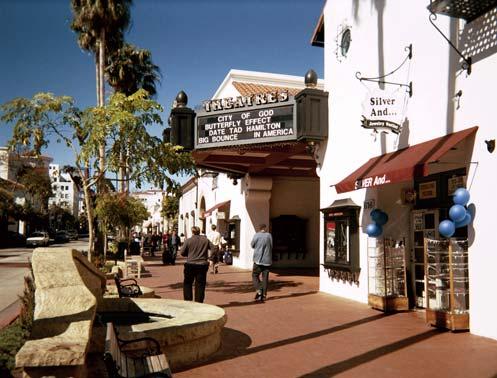
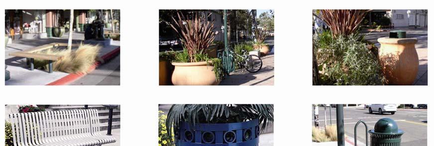
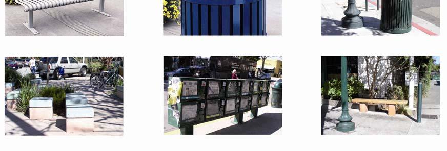
Policy 2. Encourage pedestrian circulation in commercial areas through the provision of convenient parking facilities, increased sidewalk widths, pedestrian-oriented building designs, landscaping, street lighting and street furniture. (Alternative Modes Implementing Policy C.2)
Policy 3. Design pedestrian spaces and circulation in relationship to land uses and available parking for all new construction and redevelopment. (Alternative Modes Implementing Policy C.3)
Policy 4. Link public sidewalks to the network of public and private trail systems. (Alternative Modes Implementing Policy C.4)
Policy 5. Provide for handicapped access to and along public sidewalks and along as much of the trail system as feasible. (Alternative Modes Implementing Policy C.5)
Policy 6. Install sidewalks and trail systems within existing and new industrial developments. (Alternative Modes Implementing Policy C.6)
Policy 7. Encourage school districts to implement safety programs for pedestrians and bicyclists within the public school system. (Alternative Modes Implementing Policy C.7)
Policy 8. Maintain a Traffic Safety Commission composed of Carlsbad citizens for the purpose of studying matters of traffic and pedestrian safety and making recommendations to the City Council regarding measures to promote and improve traffic and pedestrian safety. (Alternative Modes Implementing Policy C.8)
Policy 9. Employ improved traffic control devices and monitor police accident reports to increase pedestrian and bicyclist safety. (Alternative Modes Implementing Policy C.9)
Policy 10. Prepare and maintain an inventory of all missing and incomplete sidewalk segments within the City for the purpose of prioritizing future sidewalk connections. (Alternative Modes Implementing Policy C.10)
Policy 11. Provide linkage to bus, pedestrian and bicycle routes from any new light rail commuter transit facility. (Alternative Modes Implementing Policy C.18)
Policy 12. Encourage passive and active use of the railroad right-of-way as trail linkage and bicycle pathway. (Alternative Modes Implementing Policy C.19)
3.3 Overall Land Use Patterns
3.3.1
Goals
Goal 1. A City which provides for an orderly balance of both public and private land uses within convenient and compatible locations throughout the community and ensures that all such uses, type, amount, design and arrangement serve to protect and enhance the environment, character and image of the City. (Overall Land Use Pattern Goal A.2)
3.3.2
Objectives
Objective 1. To create a distinctive sense of place and identity for each community and neighborhood of the City through the development and arrangement of various land use components. (Overall Land Use Pattern Objective B.1)
3.3.3 Implementing Policies
Policy 1. Use the Pedestrian Design Guidelines contained in this Plan to guide development of pedestrian facilities.
Policy 2. Encourage new subdivisions to incorporate street designs, appropriate widths, and standards to reduce vehicle speeds and encourage pedestrian activity.
Policy 3. Evaluate each application for development of property with regard to the following specific criteria:
• The provision of public and/or private usable open space and/or pathways designated in the Open Space and Parks and Recreation Elements.
• Contributions to and extensions of existing systems of foot or bicycle paths, equestrian trails, and the greenbelts provided for in the Circulation, Parks and Recreation and Open Space Elements of the General Plan.
• Development proposals which are designed to provide safe, easy pedestrian and bicycle linkages to nearby transportation corridors. (Overall Land Use Pattern Implementing Policy C.7)
3.4 Residential
3.4.1 Goals
Goal 1. A City with neighborhoods that have a sense of community where residents including children, the disabled and the elderly feel safe and comfortable traveling to daily destinations; where homes and trees line the streets; where central gathering places create focal points; and where recreation areas are provided for a variety of age groups. (Residential Land Use Goal A.2)
3.4.2 Objectives
Objective 1. To ensure that new development is designed with the focus on residents instead of the automobile by providing: pedestrian-friendly, tree-lined streets; walkways to common destinations such as schools, parks and stores; homes that exhibit visual diversity, pedestrian-scale and prominence to the street; and recreation amenities for a variety of age groups. (Residential Land Use Objective B.5)
3.4.3
Implementing Policies
Policy 1. Require new residential development to provide pedestrian and bicycle linkages, when feasible, which connect with nearby community centers, parks, schools, points of interest, major transportation corridors and the proposed Carlsbad Trail System. (Residential Land Use Implementing Policy C.11)
3.5 Commercial
3.5.1 Goals
Goal 1. A City that provides for the development of compatible, conveniently located local shopping centers. (Commercial Land Use Goal A.2)
3.5.2 Objectives
Objective 1. To ensure that all residential areas are adequately served by commercial areas in terms of daily shopping needs which include convenience goods, food, and personal services. “Adequately served” means no residential area is outside the primary trade area of the nearest local shopping center. (Commercial Land Use Objective B.2)
3.5.3 Implementing Policies
Policy 1. Build and operate local shopping centers in such a way as to complement but not conflict with adjoining residential areas. This shall be accomplished by:
• Providing bicycle and pedestrian links between proposed local commercial centers and surrounding residential uses. (Commercial Land Use Implementing Policy C.3)
Policy 2. Comprehensively design all commercial centers to address common ingress and egress, adequate offstreet parking and loading facilities. Each center should be easily accessible by pedestrians, bicyclists, and automobiles to nearby residential development. (Commercial Land Use Implementing Policy C.4)
Policy 3. Ensure that all commercial development provides a variety of courtyards and pedestrian ways, bicycle trails, landscaped parking lots, and the use of harmonious architecture in the construction of buildings. (Commercial Land Use Implementing Policy C.7)
3.6 Village
3.6.1 Goals
Goal 1. A City which preserves, enhances, and maintains the Village as a place for living, working, shopping, recreation, civic and cultural functions while retaining the village atmosphere and pedestrian scale. (Village Land Use Goal A.1)
Goal 2. A City which creates a distinct identity for the Village by encouraging activities that traditionally locate in a pedestrian-oriented downtown area, including offices, restaurants, and specialty retail shops. (Village Land Use Goal A.2)
Goal 3. A City that encourages a variety of complementary uses such as a combination of residential and commercial uses to generate pedestrian activity and create a lively, interesting social environment and a profitable business setting. (Village Land Use Goal A.4)
3.6.2
Objectives
Objective 1. To implement the Redevelopment Plan by developing a comprehensive plan to address the unique residential and commercial needs of this segment of the community. (Village Land Use Objective B)
3.6.3 Implementing Policies
Policy 1. Seek ways of strengthening existing establishments through façade and streetscape improvements, upgraded public and private landscaping and aesthetically-upgraded signage. (Village Land Use Implementing Policy C.4)
Policy 2. Promote the inclusion of housing opportunities in the Village as part of a mixed-use concept. (Village Land Use Implementing Policy C.5)
3.7 Transportation Corridor
3.7.1
Goals
Goal 1. A City which supports the improvement and modernization of railroad facilities within Carlsbad and the region. (Transportation Corridor Land Use Goal)
3.7.2 Objectives
Objective 1. To encourage the use of the excess railroad right-of-way for landscaping, parking facilities, recreation areas, trails and similar uses. (Transportation Corridor Land Use Objective B.2)
3.7.3 Implementing Policies
Policy 1. Adopt a comprehensive plan addressing the design and location of future commuter rail stations as well as methods of improving the appearance and public use of the railroad right-of-way. (Transportation Corridor Land Use Implementing Policy)
4.0 Existing Conditions
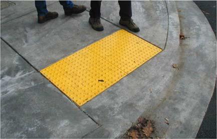
The most basic elements of the pedestrian network are sidewalks, trails, crosswalks, and curb ramps. Sidewalks provide a space for pedestrian activity separated from motor vehicle traffic. Curb ramps provide a transition between the raised sidewalk and the crosswalk for persons using mobility assistance devices. Trails also provide a separation from motor vehicle traffic, although pedestrians may have to share trails with bicyclists and other non-motorized users. These elements should form a connected network that is functional, safe, and encourages people to walk. The following sections describe the key elements of the City of Carlsbad pedestrian network, including sidewalks, curb ramps, street lights, and trails. Gaps and areas of low pedestrian facility coverage are highlighted.
4.1 Sidewalks
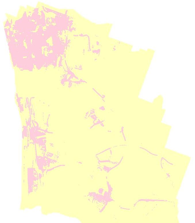
According to the most recent sidewalk inventory, there are currently about 500 linear miles of sidewalk within Carlsbad. Approximately 305 miles of a total 339 miles of publically-maintained Carlsbad roadways (or roughly 90% percent), provide sidewalks within the roadway cross-section, along one or two sides of the roadway. There are approximately 33.7 miles of roadway within the City that do not provide sidewalks. The City of Carlsbad maintains an inventory of sidewalks in a GIS database that allows the sidewalk network to be mapped and analyzed.
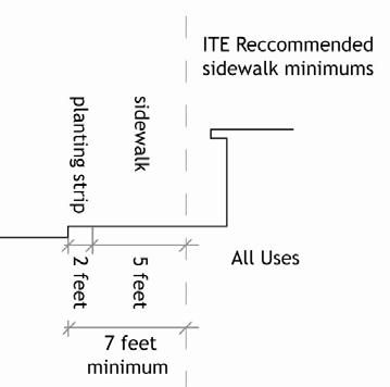
Table 4.1 summarizes roadways without sidewalks by City of Carlsbad quadrant. As shown, the Northwest and Southwest quadrants currently have the highest proportion of total roadways without sidewalks, with roughly 56.1% of all roadways without sidewalks in the Northwest quadrant, and 21.7% of all roadways without sidewalks in the Southwest quadrant. Almost 93% of the City’s sidewalks are 5 feet wide. Approximately 3%, or 14.4 miles, of City sidewalks are wider than 5 feet, ranging from 5.5 feet to 20 feet. Most of the wider sidewalks are located in the Village along Carlsbad Village Drive, State Street, Grand Avenue, Madison Avenue, and Carlsbad Boulevard along the beach. Sidewalks in downtown, where present, are typically 10 feet wide.
Figure 4-1 displays the roughly 500 total miles of existing sidewalks in the City of Carlsbad, as well as the roadways without sidewalks.
Table 4.1
City of Carlsbad Roadways Without Sidewalks by Quadrant
Source: Alta Planning + Design, City of Carlsbad 2007 Sidewalks Shapefile
4.2 Curb Ramps
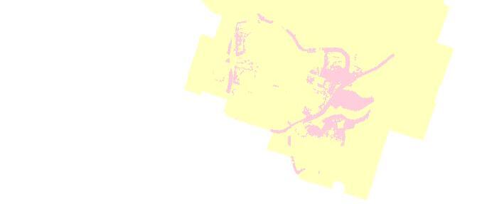
According to the most recent curb ramp inventory there are 4,623 curb ramps in the City of Carlsbad. Figure 4-2 displays intersections without curb ramps in the City of Carlsbad. Table 4.2 summarizes the City’s curb ramp conditions by city quadrant.
Table 4.2 City of Carlsbad Curb Ramp Conditions by Quadrant
Source: Alta Planning + Design, City of Carlsbad 2007 Curb Ramp Shapefile
TamarackAv
are in some of the most challenging topography of the City. These areas are characterized by newly urbanized developments providing some of the most state-of-the-art public facilities including new schools, parks, and a library. There are also several regional tourist attractions in this area including Legoland, California, the Flower Fields, the Four Seasons Resort, and the La Costa Resort and Spa.
1.2 Plan Contents
The Carlsbad Pedestrian Plan is organized according to the following chapters:
• Chapter 2: Benefits of Walking
This chapter discusses the benefits of walking for the environment, for individuals, and for the overall Carlsbad’s community. It also includes a summary of Carlsbad’s existing walking statistics.
• Chapter 3: Goals, Objectives and Policies
This chapter presents the vision for Carlsbad’s pedestrian network, based on the City’s General Plan, as well as extensive public input.
• Chapter 4: Existing Conditions
This chapter summarizes the location and quantities of key pedestrian facilities within the City of Carlsbad, including sidewalks, curb ramps, trails, and street lights. The location and quantities of missing facilities is also summarized.
• Chapter 5: Pedestrian Needs Analysis
This chapter presents an analysis of those factors – pedestrian attractors, generators and barriers – indicating high pedestrian need across the City of Carlsbad. The chapter concludes by calling out pedestrian planning focus areas that provide a framework for the identification of pedestrian projects.
• Chapter 6: Recommended Projects
This chapter presents pedestrian projects to improve pedestrian accessibility and circulation in Carlsbad. The total cost for implementing all of the recommended capital improvement projects in Chapter 6 is approximately $23 million. Project sheets are provided for top 15 priority pedestrian project locations.
Figure 4-2: 2007 Intersections Without Curb Ramps
Calle Barcelo
Approximately 91% of the curb ramps are rated as being in “good” condition, 8% are rated as being in “fair” condition, and less than 1% are rated as being in “poor” condition. Curb ramps in poor condition were identified at the following locations: El Camino Real/EB SR-78 On-Ramp, Monroe Street/Marron Road, Marron Road/Jefferson Street, Ivy Street/Daisy Avenue, and Halley Drive/Faraday Avenue.
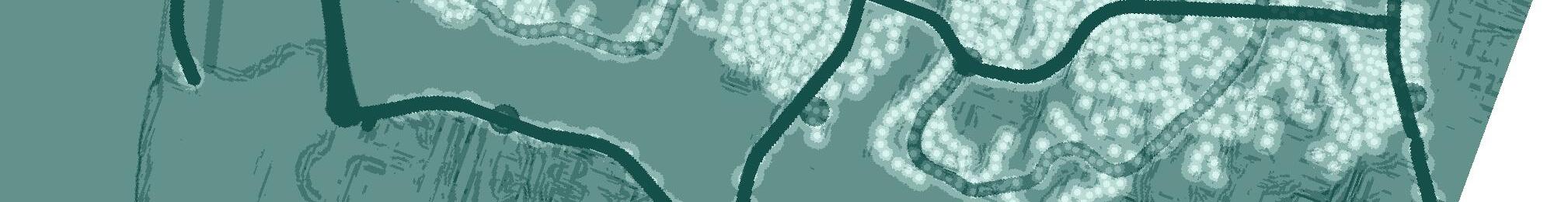
4.3 Trails
The Carlsbad Citywide Trails network covers approximately 95 miles. Figure 4-3 displays the current and planned trail system in the City of Carlsbad. Excluding existing sidewalk and bike lane connections (which account for 73.2 miles of the system), there are approximately 22 miles of trail network. There are 17.7 miles of existing unpaved trails, while the remaining trails are paved. The Carlsbad trail system includes three large sub-networks, as follows:
• Aviara Trail runs through residential subdivisions in southern Carlsbad and near Batiquitos Lagoon,
• Rancho Carrillo Trail runs through residential subdivisions in southeast Carlsbad, and
• Hosp Grove Trail is located just south of Buena Vista Lagoon in northern Carlsbad.
There are 2.3 miles of “specialty” trails including the Carlsbad Sea Wall and the Coastal Rail Trail, which runs alongside the San Diego Northern Railway in northwest Carlsbad (the right-of-way used by the Coaster commuter rail and Amtrak). Approximately 12 miles of the existing network are privately owned, though available for public use.
Future plans for the Carlsbad Citywide Trails network include the expansion of the Coastal Rail Trail south to the border with Encinitas, which would add an additional 5.5 miles of trail. There are also plans to expand the network of unpaved trails as residential development expands eastward in Carlsbad. Construction of future planned unpaved trails would add another 56.4 miles to the network.
4.4 Street Lights
Figure 4-4 displays the inventory of street lights in Carlsbad. There are a total of 7,355 street lights in Carlsbad. Nearly 71% of the existing sidewalk network is within 100 feet of a street light. Downtown Carlsbad along Carlsbad Village Drive and Grand Avenue has the highest concentration of street lights, averaging about one every 50 feet. Greater distances between street lights exists along the east-west arterial roadways south of Agua Hedionda Lagoon, such as Cannon Road, Palomar Airport Road, and La Costa Avenue. Street lighting along these roadways is typically spaced about 500 feet apart, although in some cases, exceeds 1,000 feet. Newer developed residential areas around the City have street light coverage with distances between lights rarely exceeding 250 feet
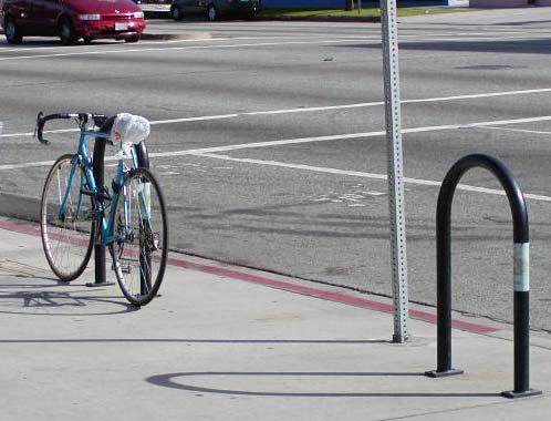
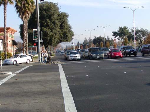
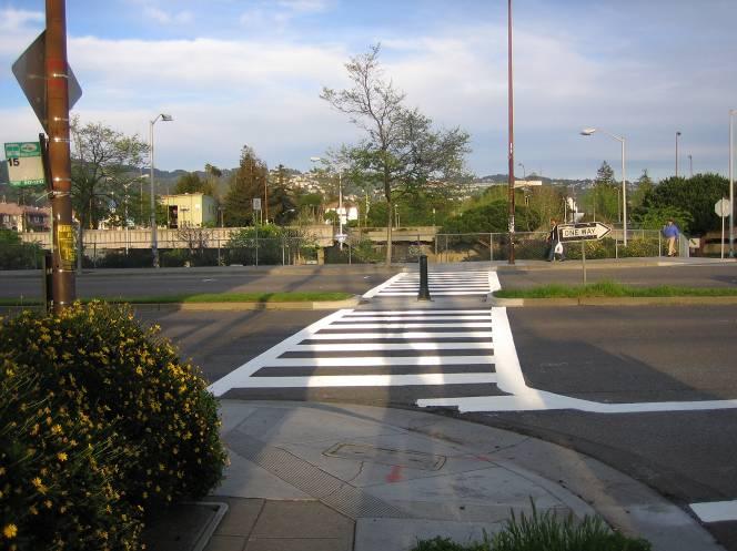
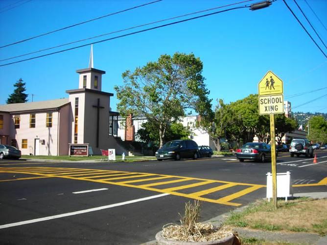
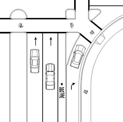
4.5 Crosswalks
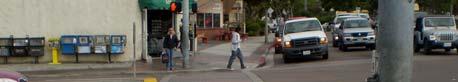
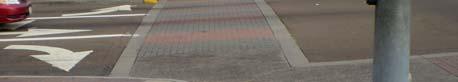
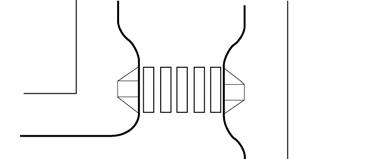
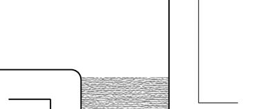
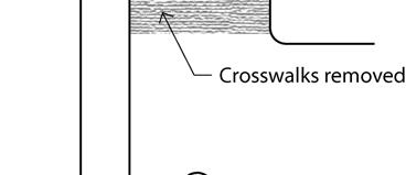
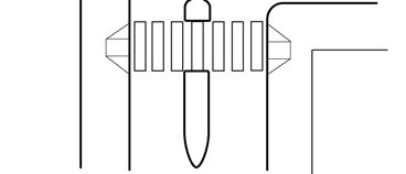
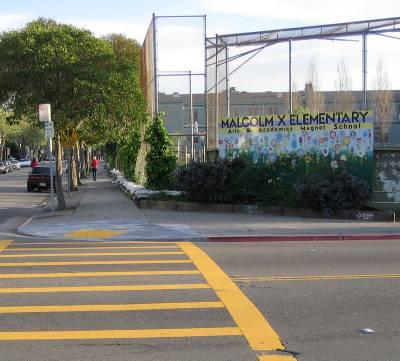
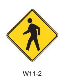
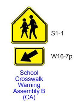
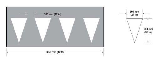
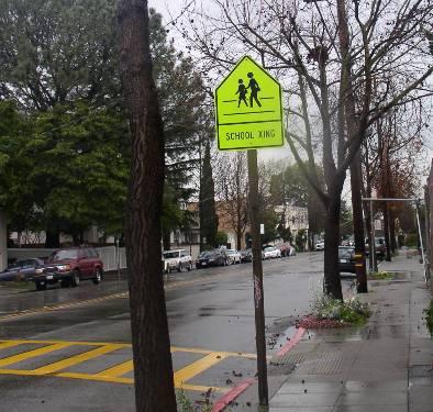
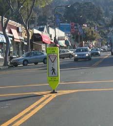
The majority of crosswalks in Carlsbad are transverse crosswalks, however high visibility ladder crosswalks are employed in various locations. The Carlsbad Village also has a system of crosswalks with brick pavers and transverse striping. A majority of the schools in the city employ yellow crosswalks near schools consistent with MUTCD recommendations.
5.0 Pedestrian
Needs Analysis
We are all pedestrians at some point during the day, whether or not we walk the entire way to a destination, walk to transit, or simply walk to and from our car into a building. One goal of this plan is to evaluate indicators of current or potential pedestrian demand across the City of Carlsbad, such as presence of schools, transit centers, youth and elderly. Studying the distribution of certain population segments and land use types in Carlsbad helps us to understand where the greatest potential for a walking trip might be, and thereby allows the city to focus its resources in these areas.
In addition to understanding the potential demand for walking, it is also important to understand current and potential barriers to walking, such as freeways, rail rights-of-way, unsafe intersections, and poor facility connectivity.
The key outcome of the pedestrian needs analysis presented in this chapter is a thorough understanding of current and potential pedestrian demands and barriers in the City, which then become the focus for project recommendations in Chapter 6.0.
5.1 Pedestrian Generators
This section summarizes the location and intensity of pedestrian generating land uses and subpopulations across Carlsbad. This analysis guides the planning process toward those areas of Carlsbad where investments in pedestrian facilities is most beneficial in terms of the current propensity for pedestrian activity 4 .
5.1.1 Total Population and Employment Density
Population density, measured as the number of persons per acre of residential land, is a strong indicator of potential pedestrian activity. Generally, higher population densities are associated with more urban environments, which tend to support pedestrian travel through mixed land uses and interconnected street networks.
4 The analysis of pedestrian generators and attractors is based upon methodologies employed by the City of San Diego’s 2006 Draft Pedestrian Master Plan Citywide Implementation Framework Report. This methodology received broad pubic review by the City of San Diego and was widely supported by San Diego Association of Governments staff.
Figure 5-1 displays population density for the City of Carlsbad. As shown, the Village has some of the highest population densities within the City, ranging from 25 to 60 persons per residential acre. Low population densities occur in the City’s southeast quadrant south of Rancho Santa Fe Road and just north of the City’s border with Encinitas. There is a noticeable absence of population density in the central portions of the City, north of Palomar Airport Road, where the land uses are predominately office and industrial. Residential development is limited in this area in large part due to McClellan-Palomar Airport.
Figure 5-2 displays employment density for the City of Carlsbad. There are several locations with high concentrations of employment, including the Village, the area between Cannon Road and Palomar Airport Road, and the area along Marron Road which is the site of the Westfield shopping center. Low employment densities occur in the southeast quadrant, in the area bordered by Aviara Parkway and Rancho Santa Fe Road.
5.1.2 Pedestrian Dependent Sub-Populations
This section summarizes population characteristics associated with higher levels of walking, including youth, elderly, physically disabled, and median household income. Certain population characteristics, such as age and household income, have been shown to influence pedestrian activity. For example, youth tend to walk more given they cannot legally drive; elderly and physically disabled tend to walk or use sidewalk facilities more given physical impairments which may restrict their ability to drive; and finally, lower income households tend to walk more given their lack of access to vehicles for driving. Mixed land uses tend to generate higher levels of pedestrian activity since multiple and varying opportunities within close proximity of each other creates shorter trip lengths, which in turn increases the propensity to make a trip on foot.
Figure 5-3 displays the distribution of population younger than 16 years across Carlsbad. The distribution and intensity of youth generally follows the overall population density patterns, although there is a notable concentration of youth in the census block groups adjacent to Interstate 5, between Carlsbad Village Drive and Tamarack Avenue.
Figure 5-4 displays the distribution of population older than 65 years across Carlsbad. Locations of higher concentrations of elderly population generally follow similar patterns to the overall population, with notable concentrations in the census block groups along Carlsbad Village Drive,
• Chapter 7. Encouraging People to Walk
This chapter presents non-infrastructure programs intended to educate, encourage and increase awareness of pedestrians in Carlsbad.
• Chapter 8: Implementation and Funding
This chapter focuses on implementation and funding for the Pedestrian Master Plan and sets out a program of projects to be implemented over the next 20 years. This chapter also outlines available regional, state and federal funding sources that can provide project funding and a brief description of program features such as minimum local match requirements or limitations on eligible projects.
1.3 How Citizens Can Use This Plan
Citizens can use this Pedestrian Master Plan to ensure that pedestrian needs and conditions are properly identified, and assist the City in keeping this Plan accurate over time as it is updated. Citizens can also identify City priorities and proposals and how and when they may impact their own neighborhoods or walking routes. Most importantly, citizens can use this Plan to identify the various tools and strategies that are available to improve conditions on their streets, and work with the City to help fund and implement these improvements.
1.4 How Will the City Use This Plan
This document will serve as a technical resource for the City to guide the implementation of goals and policies in Chapter 3. This document will help City staff with the following steps:
• Understand the constraints, opportunities and setting that will define project feasibility
• Identify appropriate programs and plans
• Identify areas where further neighborhood input is necessary
• Prioritize projects
• Identify funding sources
Figure 5-3: 2000 Youth Population (Age < 16 years) Per Acre
Poinsettia
2.0 Benefits of Walking
2.1 Why Walking is Important
Walking is important to Carlsbad’s future due to its potential to address several interrelated challenges, including traffic, air quality, public health and creating a sense of community. By planning a city that is more walkable than current development patterns allow, the City can affect all of these areas, which collectively can have a profound influence on existing and future quality of life in Carlsbad.
2.1.1 Traffic and Air Quality
Each time a Carlsbad driver chooses to walk, one car is removed from the road. As Carlsbad becomes more inviting to pedestrians, increasing numbers of shopping, restaurant, school and recreational trips will be made on foot. Cumulatively, this pattern may reduce traffic in some neighborhoods, which can also improve air quality. Because pedestrians breathe air without the benefit of air conditioning and tend to respire at a faster rate than automobile occupants, improving air quality in walkable communities is even more important than elsewhere.
2.1.2 Public Health
In recent years, public health professionals and urban planners have become increasingly aware that the impacts of automobiles on public health extend far beyond asthma and other respiratory conditions caused by air pollution. There is a much deeper understanding of the connection between the lack of physical activity resulting from auto-oriented community designs and various health-related problems such as obesity and other chronic diseases. Although diet and genetic predisposition contribute to these conditions, physical inactivity is now widely understood to play a significant role in the most common chronic diseases in the US, including coronary heart disease, stroke and diabetes 1—each of which is a leading cause of death in Carlsbad. In 2003-05 (the most
1 McKenna, M.T., Taylor, W.R., Marks, J.S., & Koplan, J.P., “Current issues and challenges in chronic disease and control” in Chronic Disease Epidemiology and Control, 2nd edition, American Public Health Assn. , 1988.
recent period for which data is available) 26 percent of all deaths in the north coastal region of San Diego County were from heart disease 2. Stroke and diabetes were responsible for an additional nine percent of deaths during this period.
Figure 2-1 shows that walking statistics for San Diego County are a small margin greater than statewide statistics. The Figure shows responses to the survey question: “Have you walked for transportation, fun, or exercise during the past week?” As shown, nearly 21 percent of San Diego County respondents and 22 percent of California respondents did not walk for any purpose in the previous week.
Physical inactivity can lead to the growing trend of obesity. As Figure 2-2 shows, obesity or body mass index (weight in kilograms divided by height in meters squared) has been on the rise for the last decade in California.
2 County of San Diego, HHSA, Public Health Services, Community Health Statistics Unit, 2007
Figure 2-1: Walking Trips based on California Health Interview Survey
San Diego County California
Source: 2005 California Health Interview Study
Source: CDC.gov
Annual Obesity in California by Body Mass Index
Like the state of California, San Diego County also has a growing trend of obesity. Figure 2-3 shows BMI categorized as underweight, normal, overweight and obese. As shown, San Diego County has approximately two percent more respondents within the normal category than the state of California; however a majority of respondents were either overweight or obese in both the County and the entire state.
Source: 2005 California Health Interview Study
Figure 2-2:
Figure 2-3: Obesity in California and San Diego County
Obesity alone is a health issue and it can also lead to other chronic diseases such as heart disease and diabetes. According to the County of San Diego Health and Human Services Department, heart disease was a leading cause of death between 2003 and 2005 in the County. By providing a pedestrian-friendly environment more people will walk on a regular basis and can help reverse these health trends.
In response to these trends, the public health profession has begun to advocate for the creation of walkable neighborhoods as one of the most effective ways to encourage active lifestyles. Studies show that 43 percent of people with safe places to walk within 10 minutes of home meet recommended activity levels, compared to only 27 percent of those without safe places to walk. 3 As Carlsbad becomes a more walkable city, Carlsbad’s population will have more opportunities to exercise, ideally resulting in a higher proportion of Carlsbad residents achieving recommended activity levels.
2.1.3 Sense of Community
City’s in which people walk provide more opportunities for chance meetings than do areas where travel is primarily by automobile. Such serendipitous encounters help neighbors get betteracquainted and provide eyes on the street, which can make an area feel and be safer. Carlsbad residents’ sense of living in a cohesive community will be enhanced as the City focuses future residential growth in compact, walkable communities, creates shopping districts that cater to those on foot, and provides facilities that enhance the pedestrian experience.
2.2 Current Walking Rates in Carlsbad
According to the 2000 Census, 775 people in Carlsbad reported walking to work. This represents about 0.79% of the commuting population of the City. The proportion of Carlsbad commuters who walk is less than that for the overall San Diego region, which is approximately 3.4%. Figure 2-4 displays the percent of pedestrian commuters by census block groups. Population residing in the Village reported the highest rates of pedestrian commuting. There are also pockets of high
3 Powell, K.E., Martin, L., Chowdhury, P.P., “Places to walk: Convenience and regular physical activity” in American Journal of Public Health, 2003.
Figure 2-4:
pedestrian commuting in the area roughly bound by Monroe Street, Carlsbad Village Drive, El Camino Real and Tamarack Avenue; and at the southwest corner of Avenida Encinas and Poinsettia Lane.
Figure 5-4: 2000 Senior Population (Age > 65 years) Per Acre
Poinsettia
west of Interstate 5; at the southeast corner of El Camino Real and Cannon Road, and at the southwest corner of Avenida Encinas and Poinsettia Lane.
Figure 5-5 displays the distribution of physically disabled population across Carlsbad. As shown, disabled populations are clearly concentrated in the Village, in the area bound by Carlsbad Village Drive on the north, Interstate 5 on the east, Carlsbad Boulevard to west, and Tamarack Avenue to the south.
Figure 5-6 displays the household income patterns across the City of Carlsbad. As shown, there is a distinct concentration of low income households in the area west of I-5, between Chestnut Avenue and Laguna Drive.
5.1.3 Final Pedestrian Generator Map
Figure 5-7 displays the final pedestrian generator map of all pedestrian generators for the City of Carlsbad, including population and employment densities, presence of population subgroups and mixed land uses. This map was developed using a GIS tool called Spatial Analyst which combines all of the individual generators, as discussed in the previous sections, into a single, composite file. The pedestrian generators are weighted individually, with higher values assigned to locations with higher levels of pedestrian generating features. Differing multipliers are also applied to the various pedestrian generators to account for the relatively greater importance of some generators over others. Table 5.1 displays the pedestrian generators, along with the associated weights and multipliers.
Figure
PoinsettiaLane
Poinsettia
Figure
Table 5.1
Pedestrian Generator Weights and Multipliers Used to Create the Final Pedestrian Generator Map
Sources: Alta Planning + Design; City of Carlsbad Shapefiles, 2000 U.S. Census Bureau, City of San Diego Pedestrian Master Plan
Interpreting the weight and multiplier values assigned to one of the generators is useful for understanding this process. In the case of population density, three classes of density were defined (>25 persons per acre, 5 - 25 persons per acre, and <5 persons per acre). Point values were then assigned to the different classes, with higher population densities receiving higher point values. A multiplier value of 1 or 2 was applied to all of the generators. Those generators receiving a multiplier of 2 should have a greater effect on pedestrian activity than those generators receiving a multiplier of 1. The population density generator was assigned a multiplier of 2, meaning that it is more highly correlated with walking than some of the other pedestrian generators. The weight and
multiplier values were similarly applied by the City of San Diego in their 2006 Draft Pedestrian Master Plan
As shown in Figure 5-7, the final pedestrian generator map identifies several high-generator areas within Carlsbad, especially within the northwest quadrant of the City, and several smaller high generation areas within the southwest and southeast quadrants.
5.2 Pedestrian Attractors
This section summarizes the distribution of various land use types across the City of Carlsbad that are typically associated with high levels of walking, especially land use types that attract a pedestrian trip. Such land uses include schools, transit stops, parks, beaches, retail, and civic facilities (libraries, post offices, and government buildings).
5.2.1 Schools, Parks, and Other Pedestrian Generating Land Uses
Figure 5-8 displays schools, parks, and other pedestrian attracting land uses. As shown, these land uses are fairly evenly distributed across the City of Carlsbad.
5.2.2 Transit Stops and Ridership
An important focus for pedestrian travel is the public transit system, since a large percentage of transit riders typically do not own cars, and must access the transit system on foot. Carlsbad is served by the North County Transit District (NCTD) which operates a total of 15 bus routes within the City boundary. Figure 5-9 displays 2005 transit stops within the City of Carlsbad. There are a total of 219 transit stops in the City of Carlsbad, with ridership ranging from 1 to 3,273 daily boardings and alightings. Of the 219 transit stops, only thirteen stops average more than 50 boardings and alightings per day. The NCTD operates the Coaster Commuter Rail which provides service between the City of Oceanside and downtown San Diego. Carlsbad has two Coaster stations, one at Poinsettia Lane and the other at Carlsbad Village Drive. The two Coaster stations and the Plaza Camino Real Transit Center have the highest demand of all transit facilities within the City, averaging over 1,000 boardings and alightings per day.
Figure 5-8: 2006 Schools, Parks and Other Pedestrian Attracting Land Uses
PoinsettiaLane
5.2.3 Final Pedestrian Attractor Map
Figure 5-10 displays the final pedestrian attractor map, as described in the previous sections, for the City of Carlsbad. This map was developed using a GIS tool called Spatial Analyst which combines all of the individual attractors into a single, composite file, with higher values assigned to locations closer to the pedestrian attracting land use and lower values assigned to locations further away from the pedestrian attracting land uses. Whereas the assessment of pedestrian generators was based mainly upon concentration of various population characteristics, pedestrian attractions are assessed in terms of distances to/from the attractor.
Varying weights were assigned to all locations within the City of Carlsbad based upon their proximity to pedestrian attracting land uses. Concentric rings or buffers were created emanating out from the pedestrian attracting land uses. The buffer distances assessed include: within one-eighth mile of an attraction, between one-eighth and one-quarter mile of an attraction, between one-quarter and one-third mile of an attraction, and between one-third and one-half mile of an attraction. Weight values are highest within one-eighth mile of an attracting pedestrian land use, and lowest in locations between one-third and one-half mile of a pedestrian attracting land use.
Table 5.2 displays the distance-based weight values assigned to the respective buffers around the pedestrian attracting land uses.
Source: Alta Planning + Design, City of San Diego Pedestrian Master Plan
Table 5.2
City of Carlsbad
Multipliers
Batiquitos Lagoon
Agua Hedionda Lagoon
Buena Vista Lagoon
Table 5.3 displays the weights applied to the various pedestrian attracting land uses, along with the associated distance-based multipliers.
Table 5.3
City of Carlsbad
Source: Alta Planning + Design, City of San Diego Pedestrian Master Plan
As shown in Figure 5-10, the final pedestrian attractor map identifies several high-attraction areas within Carlsbad, especially in the northwest portion of the City, north of the Agua Hedionda Lagoon. There are also several smaller concentrations of high pedestrian attraction areas between Palomar Airport Road and Poinsettia Lane, along the Interstate 5 corridor, along El Camino Real, and along Rancho Santa Fe Road, between La Costa Avenue and Calle Barcelona.
5.3 Pedestrian Barriers
This section summarizes the distribution of various factors across the City of Carlsbad which tend to discourage people from walking. Indicators of pedestrian barriers include pedestrian/vehicle collisions, high traffic volumes, absence of street lights, high posted speed limits, steep slopes, and un-traversable infrastructure, specifically freeway and rail corridors.
These types of barriers generally undermine broadly accepted walkability goals of safety, connectivity, and walkability. For example, presence of infrastructure and natural barriers inhibit pedestrian network connectivity. High accident rates, high speeds and traffic volumes, and low street lighting coverage are generally indicators of low levels of pedestrian safety. The following sections describe the pedestrian detractors individually and then the methodology for creating a composite detractor map for the City of Carlsbad.
5.3.1 Freeways, Rail and Slopes
Figure 5-11 displays topographical slopes and infrastructure-related barriers, specifically freeway and railroad corridors. Slopes over 25% were considered high pedestrian detractors. As shown, Carlsbad is traversed by several areas with slopes greater than 25%. Two transportation corridors, Interstate 5 and the rail corridor, also run the entire length of the City from north to south, and are significant barriers to east/west pedestrian travel.
5.3.2 Vehicular Travel Characteristics
Figure 5-12 displays existing traffic volumes and posted speed limits. Roadways with high traffic volumes, over 45,000 Average Daily Trips (ADT), were considered high pedestrian detractors, as were roadways with posted speed limits over 45 mph.
5.3.3 Pedestrian Accidents
This section summarizes recent pedestrian-related accidents within the City of Carlsbad. A total of 123 pedestrian-involved crashes in Carlsbad were reported to police between the years 2001 and 2006. Figure 5-13 displays the distribution of pedestrian accidents across the City. Key findings from this assessment include the following:
• The intersection of Carlsbad Village Drive and Harding Street had 6 pedestrian-involved crashes – the most of any intersection within the City.
• A total of 8 intersections experienced 3 or more pedestrian-related accidents between 2001 and 2006, three of which are along Carlsbad Village Drive at Harding Street, Roosevelt Street, and Jefferson Street. The five other intersections are as follows: El Camino Real/Marron Road, I-5 NB and SB Ramps at Tamarack Avenue, Paseo del Norte/Palomar Airport Road, Monroe Street/Chestnut Avenue, and Pine Avenue/Carlsbad Boulevard.
• A total of 34 accidents (almost 28% of all accidents) occurred in the Village, west of Interstate 5 and within two blocks of Carlsbad Village Drive. An additional 15 took place in the Village to the south of Carlsbad Village Drive and north of Tamarack Avenue.
A total of 17 pedestrian accidents (or almost 14% of all accidents) occurred within a 1/16th mile of a Carlsbad freeway on/off ramp. An analysis of the time of day pedestrian-involved crashes was also conducted and resulted in several key findings. Almost half (49%) of the reported accidents took place between the hours of 1PM and 7PM. The highest one-hour rate of accidents occurred between 2PM and 3PM. Twelve percent of the accidents were reported during the morning peak
Figure 5-11: Steep Slopes and Infrastructure-Related Pedestrian Barriers
travel period between 7AM to 9AM, while twenty percent of the accidents involving pedestrians occurred during the afternoon peak travel period (4PM to 6PM).
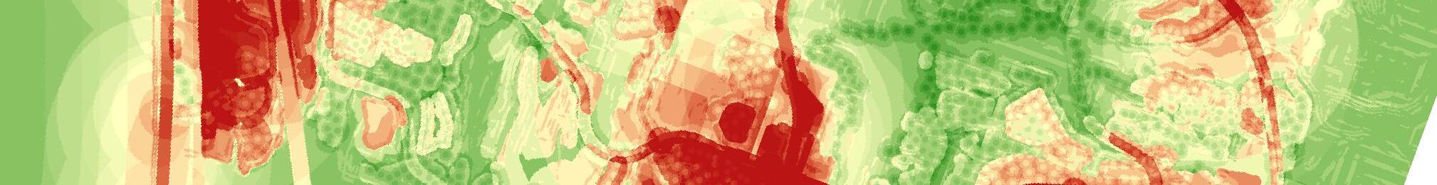
5.3.4 Final Pedestrian Barrier Map
Figure 5-14 displays the final pedestrian barrier map for the City of Carlsbad. The pedestrian barriers are weighted individually, with higher values assigned to locations with higher levels of pedestrian detracting features. Differing multipliers are also applied to the various pedestrian barriers to account for the relatively greater importance of some barriers over others. High barrier areas are weighted with higher point values and multipliers because these locations reflect areas with relatively higher need for pedestrian facility improvements. Table 5.4 displays the pedestrian barriers, along with the associated weights and multipliers. The weight and multiplier values were similarly applied by the City of San Diego in their 2006 Draft Pedestrian Master Plan.
Table 5.4
Pedestrian Barrier Weights and Multipliers
Sources: Alta Planning + Design; City of Carlsbad Shapefiles, SANDAG Shapefiles, City of San Diego Pedestrian Master Plan.
Figure
As shown in Figure 5-14, the final pedestrian barrier map identifies several high-barrier areas within Carlsbad. The freeway, rail, and major arterial corridors appear as significant pedestrian detractors. In addition, several portions of the northwest quadrant have more diffuse areas of high pedestrian detracting features.
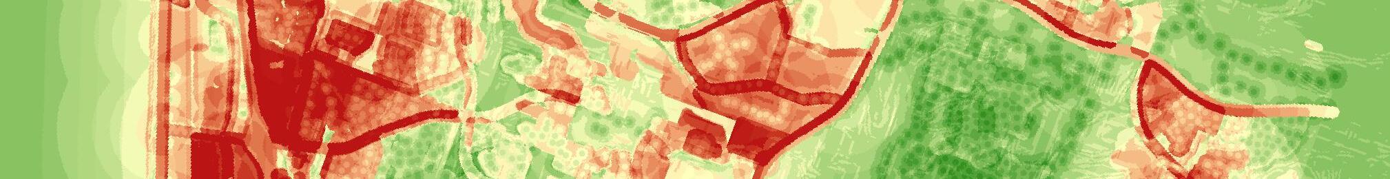
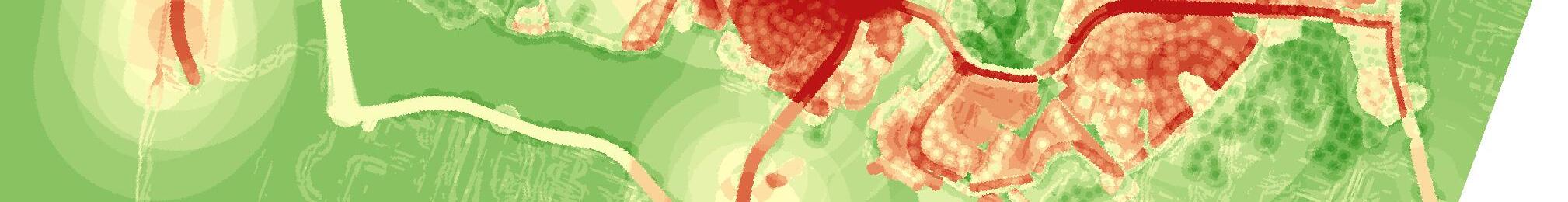
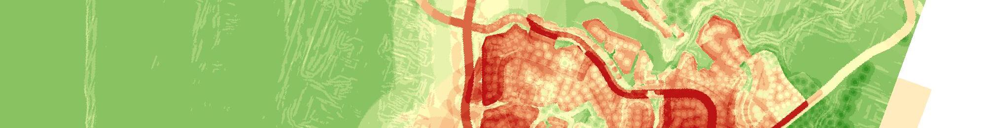
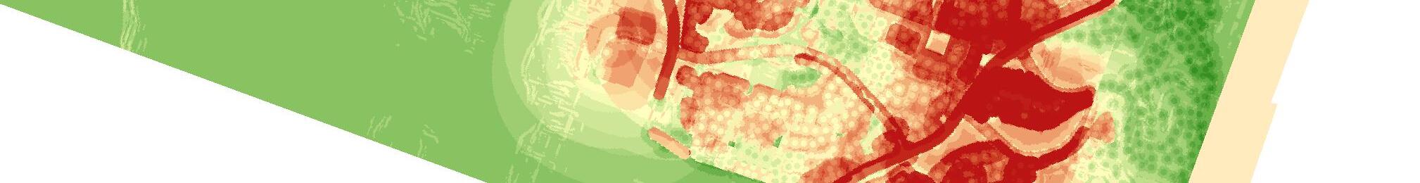
5.4 High Pedestrian Need Locations
Three composite maps were constructed and used as the basis for developing a “final pedestrian need” map intended to reflect those areas across Carlsbad that warrant high consideration for pedestrian projects and improvements. The final pedestrian need map incorporates consideration of both those areas with high pedestrian travel demands (in terms of pedestrian trip generation and attraction) and high pedestrian barriers.
Figure 5-15 displays the final pedestrian need map. There are four to five significant concentrations of high pedestrian need across the City of Carlsbad. Those include the following locations:
• The entire northwest quadrant,
• The western coastal area of the City, between Cannon Road and Batiquitos Lagoon,
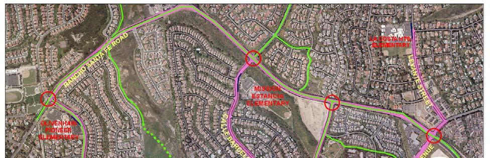
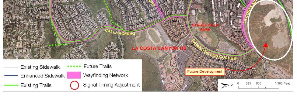
• Several locations along El Camino Real, at Aviara Parkway/Alga Road and at La Costa Avenue, and
• A large area emanating from the intersection of La Costa Avenue and Rancho Santa Fe Road.
Figure 5-16 defines more discrete Pedestrian Priority Areas that formed the basis for project identification presented in the next chapter.
Figure 5-15: Carlsbad Pedestrian Need Map
Batiquitos Lagoon
Agua Hedionda Lagoon
Buena Vista Lagoon
6.0 Recommended Projects
This chapter discusses capital project recommendations for Carlsbad’s pedestrian network. These infrastructure improvements are intended to enhance pedestrian access and circulation as well as help pedestrians feel more comfortable when walking in Carlsbad. This chapter focuses on engineering and infrastructure. Chapter 7 discusses programs and other non-infrastructure improvements to enhance the walking environment in Carlsbad.
A number of recommendations are made for infrastructure projects that should be implemented on a broad citywide basis. These projects were divided into six major categories of improvements: Infill of Sidewalk Gaps, Americans with Disabilities (ADA) Improvements, Signalized Intersections, Uncontrolled Crosswalk Improvements, Signage Improvements, and Safe Routes to School. As part of the citywide improvement project descriptions, specific recommendations are made for prioritizing these improvements, so that the city can implement them in a logical manner based on the areas of greatest need first. The pedestrian needs analysis presented in Chapter 6 provided the foundation for project prioritization.
Following the citywide project recommendations, fifteen (15) of the highest priority project locations are identified and shown with preliminary project improvement plans. These projects seek to improve specific intersections, corridors, or other locations that were identified through the existing conditions review, extensive public input, and the pedestrian needs analysis.
Project implementation requires that all pedestrian projects and programs be implemented through Carlsbad’s Capital Improvement Program process. This includes a public review process and project approval from the City Council. Cost estimates for the projects discussed in this chapter are shown in Appendix B of this plan. Total costs for implementing the capital improvements described in this chapter is approximately $23 million.
6.1 Pedestrian Facility Prioritization
Pedestrian facilities were prioritized through a multi-part process which relied upon public input (see Appendix A), the pedestrian needs analysis presented in Chapter 5, and project team field reviews. This extensive data was utilized to develop a listing of twenty-seven (27) corridors and sixty-six (66)
intersections that should receive priority from the City as it pursues pedestrian improvement projects.
Appendix C displays the priority corridors and intersections, along with each facility’s ranking.
Figure 6-1 displays the location of priority corridors and intersections across the City of Carlsbad.
6.2 Citywide Pedestrian Improvements
This section summarizes recommended improvement projects applicable on a citywide basis and those identified for application to priority corridors and intersections.
6.2.1 Infill of Sidewalk Gaps
Sidewalk gaps are areas in Carlsbad where there are no sidewalks, or the sidewalk ends abruptly, resulting in a discontinuous pedestrian network. Areas without sidewalks may force pedestrians to walk along the edge of the roadway, or may cause pedestrians to cross at undesignated crossing locations. Providing a continuous pedestrian sidewalk along all of Carlsbad’s roadways is recommended.
Figure 6-2 displays locations of roadway segments in Carlsbad with sidewalks missing on both sides of the roadway. Appendix B lists roadway segments in Carlsbad where sidewalks are missing along both sides of the street. The length of the missing sidewalk is shown along with an overall cost associated with completing all sidewalk infill projects across Carlsbad. As shown in Appendix B, there are approximately 275,620 feet–or 52.2 miles–of missing sidewalks in the City of Carlsbad. The majority of the missing sidewalks are in the Northwest quadrant, east of I-5 and north of Tamarack Avenue. Some of the roadways in the Northwest quadrant are classified as Alternative Design Streets, in which case, the City may forego sidewalk infill. In locations near schools, however, it is recommended that the City pursue sidewalk infill for improved safety of children walking to and from school.
RECOMMENDATION: As a first priority, Carlsbad should fill sidewalk gaps located in the Village area. A second priority is to complete missing sidewalk segments along Carlsbad Boulevard.
List of Tables
Figure 6-1: Priority Intersections and Corridors
Figure 6-2: Roadways Without Sidewalk, Intersections Without Curb Ramps,
Recommended Intersections for Truncated Domes
1.0 Introduction
The City of Carlsbad Pedestrian Master Plan guides the future development and enhancement of pedestrian facilities within the city, and intends to make walking an integral mode of transportation in Carlsbad. This plan was developed with extensive input from the community and seeks to meet Carlsbad’s needs and desires for pleasant, enjoyable and safe places to walk.
What will Carlsbad be like for pedestrians in the future? This Master Plan offers a vision of a future Carlsbad where:
• People can conveniently walk to their destinations.
• People feel safe walking.
• Facilities are provided for people from all age groups.
• People with disabilities are more easily mobile.
• Visitors are attracted to the enhanced walking environment.
• Commercial streets are exciting places to visit.
The goals, policies and strategies outlined in this Plan can turn this vision into a reality. It includes phased recommendations that will encourage people to walk more for short trips, enhance the environment for people with disabilities and children walking to school, and lead overall to an increase in the number of pedestrian trips. It focuses on enhancing pedestrian safety in crosswalks and along streets, and provides a blueprint for improving residents’ quality of life, creating a more sustainable environment, and reducing traffic, noise and energy consumption.
Carlsbad City leaders, staff and residents are committed to ensuring that future growth results in a city with a truly multi-modal transportation network, where pedestrian facilities are fully integrated and residents can walk comfortably and pleasurably between a variety of destinations. This pedestrian plan builds on Carlsbad’s past planning efforts to enhance the pedestrian environment in future development. Providing these walking opportunities will decrease residents’ dependence on vehicles, and will help to preserve and promote Carlsbad as a place where people want to live, work, and visit.
1.1 Setting
The City of Carlsbad is situated in the northwest corner of San Diego County along the Pacific Ocean. It encompasses approximately forty square miles of land, and is bordered on the north by the City of Oceanside, on the northeast by the City of Vista and the unincorporated County of San Diego, on the east by the City of San Marcos, and on the south by the City of Encinitas. With a current population of about 104,000, it is the fifth most populated city in the San Diego region. The topography of Carlsbad varies, with three significant lagoons traversing the city east to west (Buena Vista Lagoon, Agua Hedionda Lagoon, and Batiquitos Lagoon). Figure 1-1 displays the City of Carlsbad within the San Diego region.
One of the most vibrant areas of pedestrian activity in the City of Carlsbad is its downtown, known as the Carlsbad Village. The “Village” has a unique development character and is noted for its attractive architecture, shopping, dining, public art and inviting pedestrian streetscape. The Village is situated in the western part of what is known as Olde Carlsbad – the boundaries of the City’s original incorporation (south of Buena Vista Lagoon, north of Cannon Road, and west of El Camino Real). Olde Carlsbad is part of the more urbanized northern half of the City, and possesses quaint residential communities to the east of the Village which integrate rustic character into an attractive urban setting.
The central portion of the City surrounding McClellan-Palomar Airport functions as a large base for office and industrial employment. Residential development is limited in this area due to the proximity of the airport and industrial uses. The remaining parts of Carlsbad, to the east and south
1-1:
Figure
8.1.4 Program Costs
Costs associated with the program related recommendations are shown in Table 8.4. The budgets for recommended programs, while annualized in the table, are likely to vary considerably from year to year and are subject to grant awards and budget conditions.
Table 8.4
Costs of Programs Recommended in the Plan
Source: Alta Planning + Design; June, 2008 Note: Maintenance for new facilities recommended in plan. This estimate does not include costs to alleviate the sidewalk repair backlog or emergency repairs.
8.2 Financial Plan
The total pedestrian capital and program costs and expected revenue for the next twenty years are presented in Table 8.5. The long-term costs are based on very broad assumptions about needs in the City, and will be refined as the Pedestrian Master Plan is updated. The total 20-year cost of the pedestrian improvements and programs in Carlsbad is estimated to be $31.6 million or $1.58 million per year. The City’s FY 08/09 Capital Improvement Program identifies $3.9 million dollars in funding for sidewalk construction through build-out. Based upon the assumption that 70% of the total capital project costs, or roughly $22.1 million, could come from competitive grants, this leaves a shortfall of approximately $5.57 million over 20 years, or about $279,000 annually.
8.3 Funding Sources
Funding that can be used for pedestrian projects, programs, and plans come from all levels of government. This chapter covers federal, state, regional and local sources of pedestrian funding, as well as some non-traditional funding sources that have been used by local agencies to fund pedestrian infrastructure and programs. Table 8.6 presents a summary of various federal, state, regional and local pedestrian project/program funding sources.
8.3.1 Federal Funding Sources
The primary federal source of surface transportation funding—including pedestrian facilities—is SAFETEA-LU, the Safe, Accountable, Flexible, Efficient Transportation Equity Act: A Legacy for Users. SAFETEA-LU is the fourth in a series of Federal transportation funding bills. The $286.5 billion SAFETEA-LU bill, passed in 2005, authorizes federal surface transportation programs for the five-year period between 2005 and 2009.
SAFETEA-LU funding is administered through the State (Caltrans and Resources Agency) and regional planning agencies. Most, but not all, of these funding programs are oriented toward transportation versus recreation, with an emphasis on reducing auto trips and providing inter-modal connections.
Specific funding programs under SAFETEA-LU include:
CongestionMitigationandAirQuality(CMAQ) – This program funds projects that are likely to contribute to the attainment of national ambient air quality standards. Funds are available for projects and programs in areas that have been designated as non-attainment or in maintenance for ozone, carbon monoxide or particulate matter.
Recreational Trails Program – This program provides $370 million nationally through 2009 for non-motorized trail projects.
SafeRoutestoSchoolProgram – A relatively new program with $612 million nationally through 2009.
Transportation,CommunityandSystemPreservationProgram – This program provides $270 million nationally over five years (2006-2011) reserved for transit-oriented development, traffic
calming and other projects that improve the efficiency of the transportation system, reduce the impact on the environment, and provide efficient access to jobs, services and trade centers.
FederalLandsHighwayFunds – Federal Lands Highway funds may be used to build pedestrian facilities in conjunction with roads and parkways at the discretion of the department charged with administration of the funds. The projects must be transportation-related and tied to a plan adopted by the State and MPO. Approximately $1 billion dollars are available nationally for Federal Lands Highway Projects through 2009.
8.3.2 Statewide Funding Sources
The State of California uses both federal sources (such as the Recreational Trails Program) and its own budget to fund pedestrian projects and programs. In some cases, such as Safe Routes to School, Office of Traffic Safety, and Environmental Justice grants, project sponsors apply directly to the State for funding. Statewide funding sources are described below:
Recreational Trails Program (RTP) – The Recreational Trails Program (RTP) provides funds to States to develop and maintain Recreational Trails and trail-related facilities for both non-motorized and motorized Recreational Trail uses. The Safe, Accountable, Flexible, Efficient Transportation Equity Act: A Legacy for Users (SAFETEA-LU) defines the program at the federal level. In 2005, Congress reauthorized the RTP nationwide for $60 million in Federal Fiscal Year (FFY) 2005, $70 million in FFY 2006, $75 million in FFY 2007, $80 million in FFY 2008, and $85 million in FFY 2009. Seventy percent of the funds received by California will be available for nonmotorized projects on a competitive basis to cities, counties, districts, state agencies, federal agencies and nonprofit organizations with management responsibilities over public lands. The RTP match amount is based on the cost of the total RTP Project. The maximum amount of RTP funds allowed for each project is eighty-eight (88) percent. The applicant is responsible for providing a match amount that is a minimum of twelve (12) percent. In California, RTP funds are administered by the California State Parks Department.
Recreational Trails Program funds may be used for the following:
• Maintenance and restoration of existing trails;
• Purchase and lease of trail construction and maintenance equipment;
• Construction of new trails;
• Acquisition of easements of property for trails; and
• Operation of educational programs to promote safety and environmental protection related to trails (limited to 5 percent of a State’s funds).
Land and Water Conservation Fund – The Land and Water Conservation Fund is a federal program that provides grants for planning and acquiring outdoor recreation areas and facilities, including trails. The Fund is administered by the California State Parks Department and has been reauthorized until 2015. Cities, counties and districts authorized to acquire, develop, operate and maintain park and recreation facilities are eligible to apply. Applicants must fund the entire project, and will be reimbursed for 50 percent of costs. Property acquired or developed under the program must be retained in perpetuity for public recreational use. The grant process for local agencies is competitive. Annual apportionment allocates 60 percent of the funds to local agencies. Sixty (60) percent of those grants are reserved for Southern California.
Eligibility Criteria:
• Application package
• The Project must be consistent with issues identified in the California Outdoor Recreation Plan
• The applicant must have an assured source of eligible matching funds to meet the nonfederal share of the cost of the project
• The applicant must have adequate land tenure for Development Projects
California State-Legislated Safe Routes to School (SR2S) Program – Established in 1999, the State Safe Routes to School (SR2S) program came into effect from the passage and signing of
Assembly Bill 1475 (AB 1475). In 2001, Senate Bill 10 (SB 10) was enacted which extended the program for three additional years. In 2004, SB 1087 was enacted to extend the program three more years. A new bill, AB 57, was introduced in December 2006 to extend the program until January 1, 2013. With the passage of SAFETEA-LU in 2005, federal Safe Routes to School funds were made available to states nationwide. For this reason, current statutes will be revised to reflect SAFETEALU provisions as the State program is phased out. This program is intended to improve the safety of walking and bicycling to school as well as encourage students to walk and bicycle to school by identifying existing and new routes to school and implementing pedestrian and bicycle safety and traffic calming projects.
Evaluation Criteria (Based upon 7th cycle of the program):
• Provide a detailed description of the project scope and locations targeted for improvement.
• Describe the reasons you are applying for SR2S funds.
• Describe how your proposed solution was developed, e.g. were alternatives explored or other remedies (such as educational or enforcement measures) tested?
• Describe any ongoing and/or planned Safe Routes to School program efforts specifically targeted towards education, encouragement and enforcement activities.
• Describe how the proposed project would encourage more students to walk or bicycle to and from school more frequently.
• If the proposed project has funding sources from other agencies or grant providers, identify the funding sources, their amounts, and how the funds will complement the SR2S funds, either in additional infrastructure improvements or in the development of education, enforcement and encouragement activities.
• Describe any environmental issues or concerns that may impact the delivery of the project.
• Attach the following (a general project map; site plan for each improvement; detailed engineer’s estimate; letters of support; applicable ‘warrants’; and photographs).
Environmental Justice: Context Sensitive Planning Grants – The Caltrans-administered
Environmental Justice: Context Sensitive Planning Grants Program funds planning activities that assist low-income, minority, and Native American communities in becoming active participants in transportation planning and project development. Grants are available to transit districts, cities, counties, and tribal governments. This grant is funded by the State Highway Account and an estimated $1,500,000 in grants and up to $250,000 per application are available annually, budget permitting.
Project Criteria:
• Project Description
• Grant Objective
• State Transportation Planning Grant Goals
• Public Participation
• Project Outcomes
OfficeofTrafficSafety(OTS)Grants – The California Office of Traffic Safety distributes federal funding apportioned to California under the National Highway Safety Act and SAFETEA-LU. Grants are used to establish new traffic safety programs and expand ongoing programs to address deficiencies in current programs. Pedestrian safety is included in the list of traffic safety priority areas. Eligible grantees include governmental agencies, state colleges and state universities, local city and county government agencies, school districts, fire departments, and public emergency services providers. Grant funding cannot replace existing program expenditures, nor can traffic safety funds be used for program maintenance, research, rehabilitation, or construction. Grants are awarded on a competitive basis, and priority is given to agencies with the greatest need.
Evaluation Criteria:
• Potential Traffic Safety Impact
• Collision Statistics and Rankings
• Seriousness of Problems
• Performance of on Previous OTS Grants
8.3.3 Regional and Local Funding Sources
Regional pedestrian grant programs come from a variety of sources, including SAFETEA-LU, the State budget, vehicle registration fees, bridge tolls and local sales tax. Most regional funds are allocated by regional agencies such as the San Diego Association of Governments (SANDAG).
FY 2008 TDA and TransNet Bicycle and Pedestrian Projects Call for Projects – Each year, the SANDAG Board of Directors allocates funds under the Transportation Development Act (TDA) and the TransNet local sales tax program to support non-motorized transportation projects in the San Diego region. For FY 2007, approximately $3.5 million to $4.0 million was available for allocation.
These funds serve as part of the Regional Housing Needs Incentive Program. Board Policy No. 033 (Implementation Guidelines for SANDAG Regional Housing Needs Assessment Memorandum) sets forth guidelines for incentives related to the Regional Housing Needs Assessment (RHNA) for the 2005-2010 Housing Element cycle. Eligibility for the TDA/TransNet bicycle and pedestrian funds depend upon compliance with Board Policy No. 033, TDA Project Eligibility, and TransNet Project Eligibility.
In addition to the eligibility requirements, if applicable, certain SANDAG Claim Requirements must be met. The application must be completed and received in early February.
Key Pedestrian Criteria:
• Community Support/Consistency with Community Plan
• Minimum Design Standards
• Connect to Regional Transportation Corridor/Transit Linkage
• Completes Connection/Linkage in Existing Pedestrian Network
• Project Readiness
• Geographic Factors/GIS Analysis
• Safety Improvements
• Innovation and Design
• Regional Housing Needs Incentive
• Matching Funds
• Cost Benefit
PilotSmartGrowthIncentiveProgram(SGIP) – This innovative pilot program is based on the SANDAG Regional Comprehensive Plan (RCP) using funding incentives to encourage coordinated regional planning to bring transit service, housing, and employment together in smart growth development. Initially, the Pilot SGIP was funded with federal Transportation Enhancement (TE) Funds. Total funding included $19 million for 14 approved local projects in September 2005, with a $2 million cap per project. A longer-term, smart growth incentive program will be funded through the local TransNet half-cent sales tax program. It will provide $6 million in FY 2009 and grow over time as sales tax revenues increase.
Carlsbad has four Smart Growth Place Type classifications within the Smart Growth Concept Map: one Existing/Planned Town Center, one Potential Town Center and two Potential Community Centers. These designations qualify for application for future incentive program funds.
Project Screening Criteria:
• Local Commitment/Authorization
• Funding Commitment
• Funding Eligibility
Project Evaluation Criteria:
• Project Readiness (Level of Project Development)
• Smart Growth Area Land Use Characteristics (Intensity of Development; Land Use and Transportation Characteristics of Project Area; Urban Design Characteristics of Project Area; Related Land Development Projects; Affordable Housing)
Jurisdictions for City of Carlsbad, California: Caltrans - Caltrans District 11
SANDAG – San Diego Association of Governments
Grant Source Application Deadline Agency Program Funds Available Matching Requirement Eligible Applicants Commute Recreation Safety/ Education Comments/Contact Information
Federal Funding
Congestion Mitigation and Air Quality (CMAQ)
FHWA $8.6 billion nationwide under SAFETEALU (20052009) 20% local match State DOTs, MPOs, transit agencies
Federal Lands Highway Funds FHWA $1 billion total nationwide through 2009
Project must appear in STIP. Contact California Division, FHWA http://www.fhwa.dot.gov/cadiv/directory. htm
Grant Source Application Deadline Agency Program Funds Available Matching Requirement Eligible Applicants Commute Recreation Safety/ Education Comments/Contact Information
State Funding
California Center for Physical Activity Grant Program Ongoing Department of Health Services Up to $4,999 per grantee
None Public Health Departments
Coastal Conservancy Non-Profit Grants Program Ongoing Coastal Conservancy Grants range from $10,000 to several million Not required but favored California nonprofit 501 (c) 3 organizations
Environmental Enhancement and Mitigation Program (EEMP) Currently suspended (as of mid2006) State Resources Agency, Caltrans $10 million statewide Not required but favored local, state and federal government non-profit agencies
X For pedestrian encouragement programs Contact: Lisa Cirill, Acting Chief lcirill@dhs.ca.gov 916.552-9943
Funds for trail planning and construction and restoration of coastal urban waterfronts.
Contact Janet Diehl jdiehl@scc.ca.gov
X X Projects that mitigate environmental impacts of planned transportation projects; can include acquisition or development of roadside recreational facilities. Contact Carolyn Dudley, State Resources Agency, (916) 653-5656
Grant Source Application Deadline Agency Program Funds Available Matching Requirement Eligible Applicants Commute Recreation Safety/ Education Comments/Contact Information
$1.5 million statewide 10% local MPA, RPTA, city, county, tribal govmts, transit districts X X X
Land & Water Conservation Fund (LCWF)
May 1 California Department of Parks and Recreation
$720,000 in Southern California (2006) 50% match Cities, counties, park districts X
Funds activities that include low-income and minority communities in transportation planning and project development. Contact Norman Dong at norman_dong@dot.ca.gov or (916) 6516889.
Recreational trails are eligible for funding. Applicants must fund the entire project, and will be reimbursed for 50% of costs.
Recreational Trails Program (RTP)
Oct. 1 California Department of Parks and Recreation
$9.7 million statewide (2008-09) 20% match Jurisdictions special districts, non profits with mngmt responsibilities over land X
For recreational trails to benefit bicyclists, pedestrians, and other users; contact State Dept. of Parks & Rec. , Statewide Trails Coordinator, (916) 653-8803
Local Funding
Nontraditional Sources
Community Development Block Grants Varies HUD $526 million statewide (2004/05) None, but may be used as evaluation criteria Public entities and 501(c)(3) non-profits and tax-exempt faith-based religious orgs
Primarily for community revitalization, but may be used to fund streetscape improvements, to eliminate slum and blight in low- and moderate-income areas.
Mello-Roos
A1.2 Public Participation Process
This section summarizes the two phase public outreach effort undertaken as an aspect of the Carlsbad Pedestrian Master Plan planning process, and then synthesizes public input into a synopsis of pedestrian issues, recommendations, behaviors and attitudes of Carlsbad community members. The input obtained through this extensive outreach effort served as guidance for identifying pedestrian project opportunity areas and for developing program and infrastructure project recommendations.
A1.2.1 Overview of Community Outreach
The City of Carlsbad and their consultant employed a two phase outreach strategy to garner input from Carlsbad community members regarding their concerns about the pedestrian environment. The first phase of the effort focused on reaching out to the community at large to introduce the process and purpose of the Pedestrian Master Plan, invite participation and collect comments. The project team initiated the second, more extensive, phase of the outreach strategy while the team conducted a citywide inventory of pedestrian facilitates. This second phase involved collecting detailed information through pedestrian surveying. It also entailed targeting outreach to community groups who have high pedestrian needs, such as the parents of schoolchildren.
Phase I Community Outreach Approach
This section provides a brief chronological overview of the public outreach techniques utilized during phase I of the outreach effort.
• On June 4, 2007, the City and their consultant created and launched a project website describing the scope of the project, announcing upcoming workshops and community meetings, providing a place for public comment, and offering a contact person for further questions or concerns.
• On June 8, 2007, the City and their consultant produced and mailed a flyer inviting members of the public to an Open House to discuss the initial stages of the Carlsbad Pedestrian Master Plan. Fifty-seven flyers were mailed to homeowner associations in Carlsbad. The flyer was also sent via email to seven key contacts within the city, who then distributed the
flyer to various Commissioners. The flyer was posted on the project website in early June 2007.
• In early June 2007, the City of Carlsbad posted an announcement on the City’s official website about the Pedestrian Master Plan Open House.
• On June 23, 2007, the North County Times announced the Pedestrian Master Plan Open House in the “Community Section” of the paper. The announcement included the date, time, and location of the Open House.
• The City and their consultant held an Open House on June 28, 2007, to provide an overview of the pedestrian environment, to describe initial existing conditions, and to present an initial assessment of the pedestrian project opportunity areas. There were six stations at the Open House, and members of the community were directed to circulate and provide input at each station. A comment card was also available for community members to fill out with their input. A total of 20 members of the public attended the Open House. All public input received at the Open House is summarized and provided on the project website.
• A “City of Carlsbad Pedestrian Master Plan Survey” was prepared and uploaded to the project website in mid-July in an attempt to solicit more information about pedestrian activity levels and pedestrian facility preferences from Carlsbad community members.
• The City’s consultant disseminated and posted flyers at libraries, community centers and recreational facilities for four hours per day on September 28 and September 30, 2007 and repeated this effort on October 12 and October 14, 2007. Consultant staff devoted one day in September and one day in October to distribution in the southwestern and southeastern quadrants of Carlsbad and the other two days toward dissemination in the northern quadrants.
• In early October 2007 the City distributed a flyer via email to the City of Carlsbad’s list of subscribers who receive email notifications related to planning topics. The flyer was created by the City’s consultant to introduce community members to the Pedestrian Master Plan project and invite participation in the planning process.
Phase II Community Outreach Approach
This section itemizes efforts undertaken as elements of the extended Phase II outreach effort. The techniques and tasks were employed concurrently after the Existing Conditions Report was drafted. The extended outreach methods entailed direct contact with the public during community meetings and through intercept surveying at sites with high pedestrian activity. In total, the project team collected 98 pedestrian surveys, 10 pedestrian issue location maps, and detailed community meeting notes regarding the pedestrian issues and opportunities expressed by meeting attendees.
Attendance at School-Affiliated and Community Meetings
The consultant contacted numerous community organizations to request attendance at regularly scheduled meetings and to offer alternative or additional opportunities to reach out to organizations’ constituents. The project team especially focused on engaging Parent Teacher Association (PTA) board members and parents. All of Carlsbad’s 21 schools and affiliated PTA, Parent Organizations (PO), and Parent Associations (PA) boards were contacted. Nine of the 29 organizations were receptive to participating in the plan process either through reporting known concerns to the project team, distributing information about the plan to the school community, and/or by allowing project team members to present the project during a PTA meeting.
Within the concerted outreach timeframe, the project team was able to coordinate attendance at three PTA meetings: Jefferson Elementary on October 11, Olivenhain Pioneer Elementary also on October 11, and Aviara Oaks Middle School on October 16, 2007. In those meetings staff provided a brief overview of the project, answered questions and distributed written material related to the plan. Staff also requested that attendees complete the City of Carlsbad Pedestrian Master Plan Survey that inquires about pedestrian behaviors, attitudes, and issues related to walking in Carlsbad. This is the pedestrian survey also available on the project website. To complement the survey, staff supplied maps that were used by attendees to indicate specific problematic areas and issues by marking up the maps. Although unable to host project team members, Calvera Hills Elementary School PTA and La Costa Heights Elementary PTA presented project-related information during a school event and during a PTA meeting on October 3 and November 9, 2007, respectively.
In October the Mission Estancia Parent Teacher Association (PTA) also broadcasted the Pedestrian Master Plan general flyer and website link along with their school newsletter. Also in October, the Jefferson Elementary PTA and Aviara Oaks Middle School PTSA sent the flyer to their
organizations’ lists of parents and administrators. The project team received several email inquires as well as online surveys as a result of school email broadcasting.
In addition to outreach to schools, on October 16, 2007 project team members attended a weekly meeting at the Carlsbad Senior Center to introduce the Plan and to survey senior citizens about pedestrian challenges in Carlsbad.
Intercept Surveying
The project team set up intercept stations at public facilitates throughout Carlsbad to distribute project-related information to the public and to survey pedestrians using the City of Carlsbad Pedestrian Master Plan Survey. Teams of two consultant staff conducted outreach in this fashion for between two and four hours on seven days between September 22 and November 9, 2007. Intercepting took place throughout Carlsbad at four parks and community centers, three beach access locations, and two transit stations along with the Westfield Transit Center. The project team also operated stations at trailheads during the City of Carlsbad’s Trail Blast events held on September 22 and September 29, 2007.
While intercept surveying, team members also distributed flyers to pedestrians and answered questions related to the planning process. Consultants recorded other public comments obtained through intercept surveying at various locations throughout the City of Carlsbad.
A1.2.2 Community Input Synthesis
This section summarizes public input received through conducting Phase I and Phase II of the public outreach strategy.
Summary of Phase I Public Input
Tables A.1 through A.4 list the public comments received at the Pedestrian Master Plan Open House held June 28, 2007. Comments are categorized by table as those related to improving pedestrian facility connectivity, improving safety, improving walkability, and recommended pedestrian project opportunity areas. The tables presented reflect paraphrased commentary from the public rather than verbatim text.
Table A.1
Community-Recommended Locations for New Pedestrian Connections
Location
Chestnut Avenue, between Tyler Street & Washington Avenue
Trails near Aviara Parkway & Ambrosia Lane
Carlsbad Boulevard, north of Laguna Drive
Highland Drive, between Tamarack Drive & Carlsbad Village Drive
Poinsettia Park
Carlsbad Boulevard, between Pine Street & Tamarack Avenue.
Carlsbad Boulevard, south of Avenida Encinas
Laguna Drive
Pedestrian Issue
(as paraphased from public comment)
New pedestrian connection.
Poor trail connectivity. The trial that runs parallel to Alga Road/Aviara Parkway deadends before it reaches Aviara Oaks Middle School.
Sidewalks are needed along Carlsbad Boulevard. There is not enough separation or buffer between pedestrians and vehicular traffic.
Lacking sidewalks, curbs, and gutters. This is a school route for children attending Magnolia Elementary School, Valley Junior High School, Carlsbad Seaside Academy, and Carlsbad High School.
Sidewalks do not go completely around the park.
Signalized pedestrian crossing needed.
There are diagonal parking spaces and no sidewalks, which causes pedestrians to walk along the street.
Need for pedestrian connection from Laguna Drive to City of Oceanside.
Source: Alta Planning + Design, 6/28/07 Pedestrian Master Plan Open House
Table A.2
Community-Recommended Locations for Pedestrian-Related Safety Improvements
Pamplona Way & Alicante Road
Buena Vista Circle & Laguna Drive
Oak Street, between Roosevelt Street and Tyler Street
Intersections of Laguna Street/Madison Street and Laguna Street/Roosevelt Street
Along Camino de Los Coches and Maverick Way
Intersections at Carlsbad Village Drive and I-5 on/off ramps
All School Areas
La Costa Canyon High School
It is unsafe to cross at the crosswalks due to high vehicle speed. Need for a lit pedestrian crossing.
Unguarded trail along a steep embankment.
Needs a signalized intersection control due to nearby parks and schools.
Needs a signalized intersection due to high pedestrian activity.
Intersections need signalization due to high traffic volumes and speeds.
Create new trails or pedestrian routes to high school to promote walking.
Pedestrian crossing is dangerous; motorists do not yield to pedestrians.
Off street trails and traffic calming are needed to promote walking.
Improvements to pick-up/drop-off area to facilitate pedestrian access and reduce vehicular traffic.
Source: Alta Planning + Design, 6/28/07 Pedestrian Master Plan Open House
Carlsbad Boulevard, between Carlsbad Village Drive and Tamarack Avenue
Table A.3
Community-Recommended Locations for Improved Walkability
Location
State Street and the Village
Pedestrian Problem
(as Paraphased from Public Comment)
Dog droppings are an issue.
Along Carlsbad Boulevard, beach boardwalk, and promenade Litter and dog droppings make walking unpleasant.
Transit Stops
Walnut Avenue and Roosevelt Street (Barrio Area)
Rancho Santa Fe and Camino de Los Coches
Need better signage and improved protection from the elements.
Fear caused by traffic issues and crime inhibits walking in this neighborhood.
Need plants or vines to cover walls that developers have left blank.
Source: Alta Planning + Design, 6/28/07 Pedestrian Master Plan Open House
Table A.4
Community-Recommended Locations for Pedestrian Project Opportunity Areas
Location
Cannon Road and College Boulevard
Palomar Airport Road and El Camino Real (Bressi Ranch)
Rancho Santa Fe Road and La Costa Avenue (La Costa Town Square)
Avenida Encinas and Embarcadero Lane (Ponto Area)
Summary of Phase II Public Input
Pedestrian Problem
(as Paraphased from Public Comment)
New high school and residential development being built.
New commercial and residential development should impact traffic and pedestrian flows.
New commercial developments need pedestrian routes.
New commercial, residential, and school developments being created.
Source: Alta Planning + Design, 6/28/07 Pedestrian Master Plan Open House
This section summarizes the survey responses and public comments collected by the project team while attending PTA meetings and events and intercept surveying at key locations across the city.
Surveys and comments obtained via the project website are also incorporated into the following summary and in Table A.5 through Table A.11.
Surveys collected represent a broad cross-section of the Carlsbad public. Of the 98 respondents, 66 percent are women, 26 percent are men and 8 percent did not state their gender. The age of respondents is evenly dispersed with the largest age group represented being between thirty-six and forty-five (31 percent). Figure A1 displays the residential location of survey respondents as of October 31, 2007. As shown, public input was received from a geographically dispersed sample of
Carlsbad residents, reflecting each of the major neighborhoods across the city. The pedestrian survey asked respondents about their typical walking behaviors including frequency, distance and facility preferences. Table A.5 exhibits the frequency in which survey respondents walk or jog in Carlsbad. The vast majority of community members surveyed reported that they walk at least once a week (91 percent) and very few respondents indicated that they rarely or never walk (7 percent).
A.5
Source: Alta Planning + Design; March 2008
Of those who reported walking or jogging in Carlsbad, 60 percent of respondents primarily consider themselves exercise or recreational walkers, 15 percent are social walkers and 25 percent utilize walking most commonly as a mode of transportation to reach school, shopping, transit or work. In addition to frequency and reasons for walking, community members were asked about the distances they typically walk and the times of day that they walk in Carlsbad. Table A.6 and Table A.7 summarize responses.
Source: Alta Planning + Design; March 2008
Table
Table A.6
6.2.2 Americans with Disabilities Act (ADA) Improvements
This section presents several types of improvements that will enable the City of Carlsbad to better accommodate disabled populations and comply with Federal and State legislation. These improvements include installation of missing curb ramps and truncated domes at high priority intersections across the city.
Intersections without Curb Ramps
Figure 6-2 displays locations of intersections in Carlsbad that have no curb ramps. There are a total of 733 intersections across the city that do not have curb ramps. This would translate into the installation of a total of 2,932 curb ramps (4 curb ramps at each intersection).
RECOMMENDATIONS: As a first priority, Carlsbad should identify opportunities to install curb ramps at all arterial/arterial intersections and then establish a schedule for constructing them as feasible. Curb ramps at arterial/collector intersections should be evaluated on a case-by-case basis when the City is undertaking construction, maintenance or repair projects that affect the public right-of-way.
Truncated Domes
Truncated domes provide a cue to visually-impaired pedestrians that they are entering a street or intersection. Since 2002, ADA Guidelines (Americans with Disabilities Act Accessibility Guidelines for Buildings and Facilities, September 2002) have called for truncated domes on curb ramps. Most of Carlsbad’s curb ramps lack truncated domes, because they were constructed prior to 2002. On streets that have been constructed since 2002, truncated domes should be installed.
Although it is not required for Carlsbad to install truncated domes at existing curb ramps that were built prior to 2002, the City may wish to install these devices at all high priority intersection locations. Truncated domes are a very visible improvement, and they are relatively inexpensive to install. The preferred option for retrofitting truncated domes requires saw-cutting out a 3x4 space in the ramp in order to embed the truncated dome panel flush with the surface. While more expensive
than simply epoxying the retrofit panel to an existing ramp, the saw-cutting ensures that the domes will not become detached and pose a tripping hazard.
Appendix B displays the forty-six (46) intersection locations recommended for installation of truncated domes on the curb ramps. Figure 7-2 displays the recommended locations for installation of truncated domes on curb ramps.
RECOMMENDATION: Carlsbad should consider retrofitting truncated domes at all forty-six (46) arterial/arterial intersections where they are currently lacking, as shown in Figure 6-2.
6.2.3 Signalized Intersection
This section discusses citywide and priority improvements to signalized intersections. Signage and striping is addressed, along with signal timing adjustments, countdown signals, and audible signals.
Signage and Striping
A signalized controlled intersection provides the greatest level of traffic control for both motor vehicles and pedestrians. However, even with traffic controls, there may be conflicts between vehicles and pedestrians, due to vehicles stopping partially in the crosswalk, failing to yield to pedestrians when turning, or making a right turn on red movement while pedestrians are crossing. Although these conflicts are primarily due to motorist behavior (generally failing to yield), signage and striping improvements can help to increase motorist awareness of their vehicle placement at intersections and their need to yield.
RECOMMENDATION: The City should consider the following improvements at all of the signalized priority intersections:
1) Install Stop Lines five feet in advance of the crosswalks, to help position motorists behind the crosswalk when stopped;
2) Install “Turning Traffic Must Yield to Pedestrians” MUTCD R10-15 signage (California Manual on Uniform Traffic Control Devices, 2003), and
3) If pedestrian conflicts appear to be related to right turn on red, consider prohibiting right turn on red at that location.
Signal Timing Adjustment
Signal timing controls the amount of time each phase of a signal is allotted for vehicles and bicycles to pass through or pedestrians to cross the street. Per the MUTCD, standard traffic engineering
design assumes that pedestrians travel at 4.0 feet per second, which together with the width of the street, is used to determine the amount of time to assign to the pedestrian clearance interval. In some cases, this assumed walking speed may result in pedestrian phases that do not allow slower pedestrians, such as the elderly and children, to cross the street before the light changes. By adjusting the signal timing to a slower walking rate, slower pedestrian will have more time to cross the street. Appendix B identifies the ten (10) priority intersections for signal timing adjustments, while Figure 6-3 displays locations of signalized intersections recommended for signal timing adjustments.
RECOMMENDATION: As a first priority, Carlsbad should consider adjusting signal timing at the Jefferson Street / Carlsbad Village Drive intersection which is near the senior center, and at the eight (8) arterial/arterial intersections adjacent to elementary schools to allow for a pedestrian walking speed of 2.8 feet per second. This slower walking speed is consistent with MUTCD recommendations for walking rates for slower pedestrians. Consideration of signal operation and signal coordination by the Department of Public Works traffic engineers and signal technicians is necessary for this recommendation. As a next priority, consider implementing this signal timing walking speed for all high pedestrian demand locations in the City.
Audible Signals
Audible signals emit sounds to guide visually-impaired pedestrians indicating when it is safe to cross. Audible signals typically vary by intersection approach to assist in orienting visually impaired pedestrians. Sounds are activated by the pedestrian push-button. The MUTCD (Section 4E-06) states that installation of audible signals should be based upon engineering studies that considers the following:
• Potential demand for accessible pedestrian signals;
• A request for accessible pedestrian signals;
• Traffic volumes during times when pedestrians might be present, including periods of low traffic volumes or high turn-on-red volumes; and
• The complexity of traffic signal phasing or intersection geometry.
Appendix B lists the forty-eight (48) priority locations for installation of audible signal heads, while Figure 6-3 displays the recommended locations for installation of audible signals.
RECOMMENDATION: Carlsbad should consider installing audible signals at all forty-eight (48) arterial/arterial installations as a first priority. Locations near senior centers or where there are visually impaired residents should also be high priorities.
6.2.4 Uncontrolled Crosswalk Improvements
Infrastructure improvements at uncontrolled crosswalk locations can help increase the visibility of pedestrians to motorists and improve the pedestrian’s walking experience. These improvements are for both unmarked and marked crosswalks at intersections.
High-Visibility Crosswalk Markings
There are a variety of different striping styles for crosswalks. The City of Carlsbad utilizes two different marking styles for pedestrian crosswalks: the standard “transverse” style, consisting of two parallel lines; and the “ladder” style consisting of the two parallel lines with perpendicular ladder bars striped across the width of the crosswalk. Ladder style crosswalks should be used in locations where heightened pedestrian visibility is important, such as in school zones. Appendix B lists locations for upgrading currently marked crosswalks at uncontrolled intersections with high visibility ladder crosswalks, while Figure 6-4 displays the recommended locations for upgrading currently marked crosswalks at uncontrolled intersections.
RECOMMENDATION: Carlsbad should upgrade currently marked crosswalks at uncontrolled intersections within the priority corridors to high visibility ladder crosswalks.
Parking Restrictions
Implementing parking restrictions in the vicinity of crosswalks at uncontrolled intersections is a lowcost method of ensuring that pedestrian visibility is maintained.
RECOMMENDATION: Parking restrictions (red curb) should be installed one car length adjacent to both sides of all crosswalks recommended for upgrade to high visibility ladder crosswalks (listed in Appendix B and shown in Figure 6-4).
Signage Improvements
Parking Restrictions
High Visibility Crosswalks
Public Roads Private Roads
Figure 6-4: Recommended Locations for High Visibility Crosswalks, Parking Restrictions and Signage Improvements
6.2.5 Signage Improvements
The City of Carlsbad’s current pedestrian-related signage consists of a mix of current (California MUTCD) and older (California Traffic Manual) signs, in both standard yellow and high-visibility fluorescent yellow green. In accordance with MUTCD sign update schedule, the City of Carlsbad should develop a program to bring all signs up to current MUTCD standards. Of highest priority for pedestrians are the pedestrian advance warning (W11-2) and crossing signs (W11-2 with W16-7P down arrow).
The following considerations should be taken into account when installing signage:
1. Consistent use of standard yellow or fluorescent yellow green along a corridor or area. Avoid mixing signs of different color if possible.
2. To heighten visibility of specific pedestrian or school warning signs along major streets, consider using oversized (expressway size) sign plates.
Appendix C lists locations for upgrading signage at uncontrolled intersection crosswalks within the high priority corridors, while Figure 6-4 displays the locations of recommended signage upgrades.
RECOMMENDATION: Carlsbad should upgrade pedestrian signage along the high priority corridors at all currently marked crosswalks at uncontrolled intersections.
6.2.6 Safe Routes to School
Carlsbad has twenty-one schools located throughout the city. Proximity to schools is one of the primary factors in ranking and prioritizing the projects. Improvements near schools can benefit school-aged children walking to and from school, in addition to improving conditions for all pedestrians around the neighborhood. Several school-based projects are identified in the “top fifteen” projects presented in Section 6.3 of this chapter.
RECOMMENDATION: Carlsbad should pursue implementing a Safe Routes to School program as part of their effort to improve pedestrian safety in school areas. The City should actively pursue SR2S and SRTS grants for any needed pedestrian improvements location near school zones, several of which are included in the top 15 projects of this Plan (See Chapter 7.3 for additional information about Safe Routes to School programs).
6.3 Project Sheets
This section provides specific project improvement sheets for high priority project areas across the City of Carlsbad. This subset of projects was selected from the overall ranking of priority corridors and intersections as presented in Chapter 5, as well as a number of other factors including: 1) potential improvement recommendations that can not be accomplished through one of the citywide infrastructure project categories; 2) providing for a range of different project types, such as intersections, corridors, crosswalks, transit access, and school access; and 4) providing for a geographic balance of project locations throughout Carlsbad.
The listing of projects 1 to 15 does not reflect implementation priority; rather project implementation is likely to be a flexible process that will be based on factors such as funding opportunities, schedules for street improvements, and development or redevelopment activities. This list provides the city with a guide for implementation, to be used in conjunction with the citywide infrastructure project lists described in Section 6.2. City staff should review both the citywide and top fifteen project lists at least annually to update them for projects that have been implemented, for re-adjusting priorities as needed, and for considering any opportunities to incorporate these projects into upcoming development or street improvement activities, as well as any upcoming grant funding cycles that could be targeted.
Table 6.1 displays the top fifteen priority projects recommended for implementation in the City of Carlsbad.
1 – Plaza Camino Real Transit and Shopping Center
2 – Jefferson Street Corridor
3 – Carlsbad Boulevard (Buena Vista Lagoon Crossing)
4 – Buena Vista Elementary
5 – Carlsbad Village and Transit Center
6 – Chestnut Avenue Corridor
7 – Harding Street Corridor
8 – Carlsbad High and Surrounding Schools
9 – Jefferson Elementary
10 – Calaveras Elementary & Middle Schools
11 – Kelly Elementary
12 – South Carlsbad Boulevard Corridor
13 – Palomar Airport Road Corridor
14 – Aviara Elementary and Middle School
15 – La Costa Canyon High and Surrounding School
Source: Alta Planning + Design; June 2008
1. Plaza Camino Real Transit and Shopping Center
Study Area Description
The Plaza Camino Real Transit and Shopping Center project area extends from Jefferson Street in the west to the future Hidden Canyon Park trail head at the eastern terminus of Marron Road. The transit center at this location has the highest ridership of any transit facility in Carlsbad and generates significant pedestrian activity. The intersection of El Camino Real and Marron Road experiences heavy pedestrian traffic as people travel between shopping centers on either side of El Camino Real as well as between transit stops on the east and west side of El Camino Real. The dense trail system in this study area creates unique opportunities to join residential, shopping and recreational uses within this area. A wayfinding network is envisioned to facilitate citywide east-west connections between the future Hidden Canyon Park Trail and the coast which is approximately two miles to the west. The Westfield Plaza Camino Real suffers from poor on-site pedestrian conditions and is in need of pedestrian facility enhancements.
Issues
High average daily traffic volumes along El Camino Real
Most heavily used transit station in Carlsbad; lack of connectivity between transit center and multiple surrounding shopping areas
Poor on-site pedestrian facilities at the Plaza Camino Real shopping center
Illegal mid-block crossings between Plaza Camino Real and bus facilities on the east side of El Camino Real
Major pedestrian barriers, including El Camino Real and SR-78
Proposed Improvements
Sidewalk infill along Marron Road and Westfield Plaza Camino Real entrance at Monroe Street $136, 706
Wayfinding signage to connect major origins and destinations including trail access points, the shopping center, the Carlsbad Village, and coastal access points (8,430 feet of wayfinding network@ 1 sign/900 feet = $3,000)
Cost
$139,706
2. Jefferson Street Corridor
Study Area Description
Jefferson Street along the Buena Vista Lagoon presents a viable opportunity for a strong east-west pedestrian connection between Plaza Camino Real and the Carlsbad Village as it provides a grade-separated, interchangefree crossing of I-5 and generally circumvents the steep slopes along Monroe Street and El Camino Real.
Issues
Provides opportunity for east-west pedestrian linkage between Plaza Camino Real and downtown Carlsbad Near sensitive habitat/ecology
High recreational pedestrian demands
Proposed Improvements
Sidewalk infill
Road and Las
drive $2,101,450 Network of signage promoting wayfinding to major origins and destinations including Plaza Camino Real shopping center, Carlsbad Village, coastal access points, and trail access points (6,470 feet of wayfinding network@ 1 sign/900 feet = $2,400)
Cost
$2,103,850
between Marron
Flores
3. Carlsbad Boulevard (Buena Vista Lagoon Crossing)
Study Area Description
Carlsbad Boulevard runs north to the City of Oceanside on a narrow strip of land across the Buena Vista Lagoon. A short segment of Carlsbad Boulevard is a bridge over the narrow estuary passage of the lagoon. There are currently no paved sidewalks or adequate buffers from vehicular traffic along the corridor. Plans for a future boardwalk servicing pedestrians across the lagoon to the Buena Vista Lagoon Nature Center are under consideration.
Issues
Lack of paved pedestrian connection to City of Oceanside
Install sidewalk facilities from Carlsbad’s northern boundary and the City of Oceanside, south to Laguna Drive
4. Buena Vista Elementary
Study Area Description
The elementary school is situated along Buena Vista Way – a local residential street. Its parking lot, which also serves as the loading area, is located midblock between Pio Pico Drive and Highland Drive and is only accessible by vehicle from the west. Buena Vista Way becomes a one-way eastbound street immediately to the east of the school parking lot until its intersection with Highland Drive. Buena Vista Way is largely lacking sidewalks, except for small portions near the Pio Pico intersection. A drainage ditch runs along the south side of Buena Vista Way. The school is lacking adequate drop-off/pick-up areas along the street adjacent to the school’s parking lot. There is a double yellow line separating vehicular and pedestrian traffic along the street.
Issues
Poor visibility along Buena Vista Way due to overgrown landscaping
Lack of sidewalk facilities along Buena Vista Way and on blocks surrounding school
Inadequate drop-off/pick-up area in front of school
Non-conforming school sign assembly on Buena Vista Way and Highland Drive
Vehicular traffic during peak school periods
Proposed Improvements
Install missing sidewalk facilities along Buena Vista Way, Highland Drive, Pio Pico Way, Arland Road and Forest Avenue
$471,583
Enhanced sidewalks at drop-off/pick-up area in front of school $9,000
Parking restrictions on the northeast corner of Highland Drive and Buena Vista Way $20
High visibility restriping of the crosswalk along the east leg of Pio Pico Drive/Las Flores Drive intersection $1,200
Updated school warning traffic assembly at the northwest and southeast corners of the Highland Drive/Buena Vista Way intersection $600
Cost
$482,403
5. The Carlsbad Village and Transit Center
Study Area Description
This study area focuses on Grand Avenue, Carlsbad Village Drive, the Carlsbad Village Transit Center, and the downtown shopping streets that intersect Carlsbad Village Drive and Grand Avenue. The Carlsbad Village has the highest concentration of pedestrian activity in the city. Pedestrian safety is a major concern along Carlsbad Village Drive, where several of its downtown intersections ranked among the highest in the city for pedestrian-vehicular accidents. The streetscape along Carlsbad Village Drive does not provide for pedestrian buffers from its regularly high vehicle traffic volumes. The pedestrian environment is also negatively impacted by Interstate 5 and the San Diego Northern Railway, both of which pose major barriers to pedestrian safety and connectivity.
Issues:
High levels of pedestrian activity
Pedestrian-vehicular accidents occur along Carlsbad Village Drive
High average daily traffic volumes
Insufficient pedestrian buffers along Carlsbad Village Drive
Major barriers to pedestrian safety and connectivity caused by railroad line and I-5
Presence of key public transit station
Proposed Improvements
Signal timing adjustment at the intersection of Jefferson Street and Carlsbad Village Drive
Mid-Block crossing at Grand Avenue between Carlsbad Boulevard and State Street $72,353
Crosswalk restriping (high visibility) $9,600
Network of signage promoting wayfinding to major origins and destinations including points of coastal access, Carlsbad Village Transit Center, shopping and dining areas, and trail access points. (21,790 feet of wayfinding network@ 1 sign/900 feet = $7,500)
Sidewalk infill along Madison $39,150
Cost:
$128,603
6. Chestnut Avenue Corridor
Study Area Description
Chestnut Avenue is an important east-west corridor connecting neighborhoods separated by Interstate 5, where there is an underpass without on/off ramps. To the west of I-5, Chestnut Avenue is divided by the San Diego Northern Railroad. Pedestrian demand for coastal access in this area of Carlsbad is high – many pedestrians illegally cross the tracks to access coastal Carlsbad. Two parks are situated along Chestnut Avenue in the study area. There are sporadic gaps in sidewalk pavement along Chestnut Avenue in the study area.
Issues
Lack of east/west pedestrian connections across rail right-of-way
Segments of Chestnut Avenue with no sidewalk
Demand for coastal access
Pedestrian facilities near Holiday Park and I-5 underpass in poor condition
Proposed Improvements
Sidewalk infill and upgrade along Chestnut Avenue and Eureka Place $89,373
Add bus stop improvements (bench, shelter, and signage) at Chestnut Avenue and Harding Street intersection
$40,000
Network of signage promoting wayfinding to major origins and destinations including points of coastal access, the Carlsbad Village, parks, shopping and dining areas, and trail access points (6,097 feet of wayfinding network@ 1 sign/900 feet = $2,100)
Proposed Railway Crossing (costing not provided)
Cost
$131,473
7. Harding Street Corridor
Study Area Description
Harding Street provides a major north-south connection between multiple public facilities near Chestnut Avenue and Harding Street, and points north, near the Carlsbad Village. This corridor experiences high pedestrian demand, and also speeding vehicles. The lack of traffic control at Oak Avenue and Pine Avenue causes driver confusion. The intersection of Harding Street and Carlsbad Village Drive has high rates of pedestrian-vehicular collisions.
Issues:
Safety issues at uncontrolled crosswalks
High rates of pedestrian-vehicular collisions
Vehicles frequently travel faster than posted speed limit
Poor visibility/placement of pedestrian warning signage
Non-conforming pedestrian signage
Proposed Improvements
Install north/south stop sign control along Harding Street at the Harding Street/Pine Avenue and Harding Street/Oak Avenue intersections $1,200
Construct curb extensions at Harding Street/Pine Avenue and Harding Street/Oak Avenue intersections $372,703
Remove two overhead pedestrian warning signals along Harding Street between Carlsbad Village Drive and Pine Avenue $240
Cost: $374,143
8. Carlsbad High and Surrounding Schools
Study Area Description
There are four schools within this study area in a six block area (including Carlsbad High School, Valley Middle School, Carlsbad Village Academy, and Magnolia Elementary situated at a single intersection). Several high pedestrian demand roadways are without sidewalk facilities, including most of Highland Drive. The neighborhood experiences some traffic problems during peak school periods. Chestnut Avenue provides an important connection to the Carlsbad Village across Interstate 5.
Issues
Lack of sidewalk facilities near schools; many roadways with the Alternative Design Street classification conflict with pedestrian demand generated by schools
Presence of four schools in study area
Lack of crosswalks at key pedestrian intersections
Vehicular traffic during school peak periods
Proposed Improvements
Missing sidewalk installation $1,451,017
Enhanced 10’ sidewalks near school drop-off/pick-up $195,660
Jefferson Elementary school is situated within a residential neighborhood bound by Hibiscus Circle on the west, Interstate 5 on the east, and Tamarack Avenue to the south, which is a busy truck route designated roadway. Schoolrelated pedestrian activity in the vicinity of these significant barriers is challenging. The residential neighborhoods adjacent to the Coastal Rail Trail lack direct connections to this facility and must travel out of the way to access it.
Issues
Near Tamarack Avenue freeway interchange
Pedestrian safety during school arrival and departure periods
Proposed Improvements
Install a crosswalk along the north leg of the Tamarack Avenue/Hibiscus Circle intersection $1,200
Enhanced 10’ sidewalks at pick-up/drop-off areas in front of school $37,080
Adjust the signal timing at the Jefferson Street/Tamarack Avenue intersection
Provide a connection to the Coastal Rail Trail from Village Drive $10,000
Upgrade school sign assembly at the northwest and southeast corners of the Jefferson Street and Carol Place intersection $600
Cost
$48,880
10. Calaveras Elementary and Middle Schools
Study Area Description
Calaveras Elementary and Middle schools are situated in a single family residential area near the recreational open space area of Lake Calavera. There are several additional recreational attractions in the vicinity of the school area including Calaveras Park, El Salto Falls, and connections to city trails.
Issues
Missing sidewalk and path infrastructure along segments of Tamarack Avenue
Vehicular traffic during school peak periods
Opportunities for enhanced trail connections
Proposed Improvements
Signal timing adjustments at three intersections
Sidewalk infill
$68,324
Enhanced 10’ sidewalks at school drop-off/pick-up areas $82,350
Install Class I path connecting Calaveras Elementary and Middle schools to the southeastern existing/planned trail
$75,000
Wayfinding signage to connect major origins and destinations including the school, trail access points, and parks
Kelly Elementary School is situated in a single family residential area at the corner of Kelly Drive and Hillside Drive. There are poor pedestrian connections between the residential neighborhoods to the northwest and Kelly Elementary. There are several opportunities to provide enhanced pedestrian connection via the existing and future trail system in the study area.
Issues
Poor connectivity between school and nearby residential areas
Near major arterial road
Vehicular traffic during peak school periods
Proposed Improvements
Signal timing adjustments at two intersections
Enhanced 10’ sidewalks at school drop-off/pick-up area
$81,000
Install Class I path connecting High Ridge Avenue and Aura Circle $143,400
Install missing sidewalk facilities along El Camino Real between Tamarack Avenue and Crestview Drive
$134,744
Wayfinding signage to connect major origins and destinations including the school, trail access points, and parks (2,248 feet of wayfinding network @ 1 sign/900 feet = $900)
Cost
$360,044
12. South Carlsbad Boulevard Corridor
Study Area Description
Carlsbad Boulevard is a key north-south coastal boulevard running the entire length of the city. This study area focuses on the segment south of Cannon Road. Demand for recreational pedestrian and bicycling use is high while pedestrian facilities are mostly unpaved, and pedestrian buffers from the high levels of vehicular traffic are lacking. The interchange with Palomar Airport Road is a major connectivity barrier for pedestrians using the east side of the right-of-way. The City is considering reconfiguring this interchange into a ‘T’ intersection. The southernmost segment of the corridor in the study area is subject to future redevelopment plans.
Issues
High demand for recreational pedestrian and bicycle use
Palomar Airport Road interchange is major barrier to safety and connectivity
Large segments of roadway with no paved pedestrian facilities
City does not own portions of land along coast
Proposed Improvements
Install a multi-use path connecting existing sidewalk facilities on NB Carlsbad Boulevard between Cannon Road and Avenida Encinas $1,642,000
Network of signage promoting wayfinding to major origins and destinations including points of coastal access, Poinsettia Coaster Station, tourist destinations, shopping and dining areas, and trail access points (26,433 feet of wayfinding network @ 1 sign/900 feet = $5,400)
Cost
$1,647,400
13. Palomar Airport Road Corridor
Study Area Description
Palomar Airport Road is a major east-west arterial running between Carlsbad Boulevard and the eastern Carlsbad boundary. This study area is focused on the area west of LegoLand California. The pedestrian environment suffers from barriers caused by Interstate 5 and the rail right-of-way, as well as from very high vehicular traffic volumes. Sidewalk facilities taper off due to the limited right of way along the narrow Palomar Airport Road overpass over the rail right-ofway. In addition to LegoLand, there are several other noteworthy attractions along this corridor: the Flower Fields, the Pacific Coast, a golf course and the outlet shopping center. These tourist-oriented uses are not well connected by pedestrian facilities.
Issues:
High traffic volumes along Palomar Airport Road
Highly automobile-oriented land uses and roadway networks, with uninviting pedestrian environment
Limited pedestrian accessibility to coastal areas and tourist sites within project area
Major barriers to pedestrian safety and connectivity caused by railroad line, interchange with Carlsbad Boulevard, and topographical and engineering constraints of Palomar Airport bridge over railroad line
Proposed Improvements
Install a mid-block crosswalk at Armada Drive $72,353
Network of signage promoting wayfinding to major origins and destinations including points of coastal access, tourist destinations, shopping and dining areas, and trail access points (12,002 feet of wayfinding network @1 sign/900 feet = $4,200)
Cost: $76,553
14. Aviara Oaks Elementary and Middle School
Study Area Description
Aviara Oaks Elementary and Middle school is situated at the corner of Ambrosia Lane and Aviara Parkway. The school is in a ravine and surrounded by steep slopes on all sides. The school’s on-site loading area experiences severe traffic problems, prompting many parents to drop-off/pick-up along Ambrosia Lane. This phenomenon is also contributing to a high number of U-turns on Ambrosia Lane after parents have picked up their children. There is an activity center to the east of the schools, including a city branch library and retail uses. There are several trails in the study area, though the school is not directly served by any of them. The library lacks direct pedestrian connections to the school and nearby residential developments. The library is isolated from the rest of the shopping center with only a narrow sidewalk through the parking lot providing on-site connections.
Issues
Poor connectivity to nearby shopping and library land uses
Circulation issues during drop-off/pick-up periods
Safety of student pedestrians during peak school periods
Inadequate sidewalk waiting areas
Proposed Improvements
Install curb landing at the NE corner of the Ambrosia Lane and Conosa Way intersection $100,000
Signal timing adjustment at two intersections
Enhanced 10’ sidewalks at school drop-off/pick-up $103,410
Install Class I path facility connecting the library to Aviara Oaks schools via the northeastern baseball path. $190,362
Wayfinding signage to connect major origins and destinations including the school, trail access points, public library, and parks. (22,618 feet of wayfinding network @1 sign/900 feet = $7,800)
Cost
$401,572
15. La Costa Canyon High and Surrounding Schools
Study Area Description
The schools in the La Costa study area are fairly modern and thus have no major infrastructural deficiencies. School drop-off/pick-up periods create traffic and safety issues at Mission Estancia and Olivenhain Pioneer elementary schools. Future development is underway north of La Costa Avenue.
Issues
Vehicular traffic near schools during peak school periods
Missing sidewalks
Speeding vehicular traffic
Proposed Improvements
Enhanced 10’ sidewalks at school pick-up/drop-off $95,760
Signal timing adjustment at four intersections
Wayfinding signage to connect major origins and destinations including schools, trail access points, and parks (27,995 feet of wayfinding network @1 sign/900 feet = $9,600)
Cost
$105,360
7.0 Encouraging People to Walk
Public awareness and education programs are important complements to the proposed pedestrian improvements in this Plan. In addition to programs merely promoting walking, an educational effort should be made to cover pedestrian and motorist laws. For example, many people do not understand that motorists must yield to pedestrians crossing at intersections, regardless of whether there is a marked crosswalk in place or not. Others may be confused as to when crossing a street mid-block constitutes jaywalking. The recommended projects in this Plan promise to be most effective when accompanied by a robust campaign of enforcement of the existing laws that protect pedestrians.
7.1 Pedestrian Awareness Programs
A public awareness campaign that promotes walking as a means of transportation and emphasizes safe behavior will contribute to helping people make healthier lifestyle choices. Carlsbad’s population covers a wide spectrum that can benefit from walking, including an active senior community, students, families, and employees. In a time of escalating rates of obesity and diabetes, encouraging people to walk can provide the invitation necessary to start a lifestyle change.
7.1.1 Trail Blast Fitness Program
The City of Carlsbad Recreation Department organizes annual Spring and Fall Trail Blast events to encourage use of the Citywide Trails System for walking, hiking and running. Trail Blasts are a series of trail walks/hikes led by a professional fitness instructor and held on four consecutive Saturdays during the Spring and Fall. The program’s emphasis is promoting physical fitness but Trail Blasts have also been combined with civic activities such as a clean-up day on National Public Lands Day. It is recommended that the City continue its Trail Blast Fitness Program and consider expanding it to serve as a broad pedestrian awareness/encouragement program. Similar to the National Public Lands celebration, the final day of a Trail Blast series could incorporate information, promotional materials and other media related to the benefits of walking and pedestrian opportunities. Bumper stickers, posters, window signs, and brochures could include the following information:
• Easy ways to incorporate walking into daily activity
• Rules of the road for motorists and pedestrians
• Health benefits of walking
• Website/telephone number for more information
Existing educational materials are available through national and state agencies, or the City could develop materials for distribution that specifically promote the Trail Blast program and walking in Carlsbad. If materials are generated, sponsors could be secured to offset the cost of design and printing to the City. Sponsors’ logos can be added at the bottom of the materials. Brochures, maps, and bumper stickers could be distributed in and around Carlsbad at civic buildings, libraries, schools, local businesses and merchants associations, and community groups. The City could also develop a “Trail Blast and Walking in Carlsbad” webpage linked to the Parks and Recreation webpages that includes downloadable files and provides information on current walking events and activities in Carlsbad.
City of Carlsbad staff or a consultant can produce and arrange the distribution of printed materials and identify sponsors and funding sources to offset the costs associated with the printed material.
7.1.2 Walk to School
During the first week in October, schools around the world celebrate International Walk to School Week. The purpose of the week-long event is to educate children and their families about the social and physical benefits of walking, to teach children safe walking behaviors and to advocate for walkable communities. The National Center for Safe Routes to School promotes this event and maintains an International Walk to School in the USA website which contains promotional material and media resources. California Walk to School also assists schools throughout California with organizing Walk to School events. In Carlsbad, Calavera Hills Elementary School held a successful Walk to School event in October of 2007. It is recommended that the City promote Walk to School by coordinating with Carlsbad Unified School District to make internet resources and printed information about Walk to School available to schools, associations, parents and teachers. The City could also distribute information to the public during events such as the Trail Blasts. Walk to School promotion could serve as a facet of a citywide pedestrian safety education campaign.
7.1.3 Public Service Announcements
A cost-effective way for the City of Carlsbad to promote walking as an effective and enjoyable way to travel is to use existing television public service announcements (PSAs) made available through the National Highway Traffic Safety Administration (NHTSA), Safe Kids Coalition, and the
California Office of Traffic Safety (OTS). These agencies provide existing award-winning television public service announcements on the following topics:
• Pedestrian education for seniors
• Pedestrian education for the general public
• Pedestrian education for children and their families
• Driver education on pedestrians
• Drivers running red lights
In addition to running the PSAs on local television, the City of Carlsbad could provide local movie theatres with the public service announcements to be included as trailers on-screen.
Finally, to further utilize television and radio media to promote walking, the City could solicit the interest of local television and radio public service directors to interview a Carlsbad spokesperson to discuss the importance of walking as an alternative mode of transportation in Carlsbad. The production, arrangement, and distribution of public service announcements can be done by either City of Carlsbad staff or consultants. In addition, costs associated with production and promotional activities can be offset by sponsors and other funding sources. All activities can be conducted under the supervision of Carlsbad staff.
7.1.4 Walking Maps and Guides
One of the most effective ways of encouraging people to walk is through the use of maps and guides to show that the walking infrastructure exists, to demonstrate how easy it is to access different parts of the city on foot, and to highlight unique areas or routes. Excellent trail maps are already available including an overview map of the entire Citywide Trails System as well as digital aerial maps of trails within the citywide system. The City should consider developing similar maps that highlight pedestrian facilities intermixed with streets and roadways. An effective map could display the entire City of Carlsbad and include information on popular walking destinations including schools, parks, civic buildings, libraries, key grocery stores and markets and restaurants. Pedestrian-friendly amenities and routes could be indicated and street grades could be color-coded so that pedestrians know how steep the streets are.
7.1.5 Other Promotions
A variety of other promotions or programs could be implemented to promote walking as an effective, fun and economical way to travel in Carlsbad.
Commuter of the Month – Implement a contest for residents and employers to nominate a person who walks and/or uses transit to get around Carlsbad. Entry forms available at employer sites, retail sites, churches, and recreation and community centers could promote the contest. Monthly winners could receive prizes that may include gift certificates to dinner, retail stores, and merchandise.
Murals –- Murals have successfully been used to promote ideals and inform the community of important issues. The mural program could solicit help from local volunteers, artists, children, seniors, and other community members. Costs for the production of the murals could be generated by grants through public art foundations or as part of a City of Carlsbad Cultural Arts project.
Walk Exhibit – Carlsbad could produce a traveling mobile exhibit promoting walking and bicycling. The exhibit could feature the following elements:
• Photo displays of new facilities
• Photos of residents and employees walking
• Walking maps and guides
This exhibit could be featured at all community events including the EGGstravaganza Spring Festival, Carlsbad Loves Kids Day, Pumpkin Plunge, Fall Festival, Trail Blasts, and other events. The exhibit could be built to allow assembly and attendance to be done by one person.
EventProducers’Obligation – Carlsbad could require all community events to promote walking (and bicycling) in all event literature, advertisements, and other collateral materials as a mode of transportation to their event. The City could include this requirement as part of the permit process for events.
MonthlyEvents – First Wednesday Walks. The first Wednesday of every month could be designated as Everybody Walks day. This type of promotion has been effective in communities throughout California, such as the City of Berkeley. Sidewalk Strolls - Organized walks could be implemented for seniors at local centers. The goal of these events could be to generate interest in recreational walking for health reasons with the ultimate goal of promoting walking as a form of transportation. The production, coordination, and implementation of all promotional activities can be done by
either City of Carlsbad staff or local volunteers. In addition, costs associated with the promotional activities can be offset by sponsors and other funding sources.
7.2 Pedestrian Education Programs
Education can make pedestrians and motorists more aware of potentially hazardous environments and teach them the skills needed to make walking a more effective and enjoyable way to travel. A number of broad-based educational subjects address particular issues, with individual programs that can be tailored around a specific theme or themes.
7.2.1 Safety Education Campaign
A variety of safety education campaigns could be undertaken by the City in order to educate motorists on the rights of pedestrians, and to educate pedestrians on safe behavior. The campaign could include messages related to speeding, yielding to pedestrians in crosswalks, stopping at stop signs, red light running, or jaywalking. Particular emphasis should be given to the safety of children, seniors and people with disabilities.
Sample messages might include:
• “Save A Life – Your Own. Don’t Jaywalk.”
• “STOP! It could be someone you love in the crosswalk.”
• “Use the other pedal and slow down.”
• “Slow Down! It could be someone you love.”
• “Want to meet cops? Don’t stop for pedestrians in the crosswalk.”
Elements of a successful pedestrian education program would include:
MediaCoverageandEvents – including statements of support from city officials, support of the Carlsbad Police Department, and development of a press kit outlining the program to get media coverage.
PrintCampaign – incorporating the promotional themes in maps, posters, bumper stickers, guides, and television public service announcements.
Street Banners – that display a safety message such as “SLOW DOWN.” Rotating the banner to different neighborhoods on a regular basis can keep the message fresh and reach new audiences.
7.2.2 Enforcement Education
City staff should cooperate with the Carlsbad Police Department on ways to educate motorists during enforcement of pedestrian violations. This could include distributing materials on pedestrian rights and the benefits of walking to motorists. Bicycle patrol officers are in a particularly good position to educate pedestrians on safe and proper behavior as part of their routine activities. City staff and the Police Department should coordinate on ongoing programs to encourage pedestrian activity.
7.2.3 Senior Citizen and Disabled Pedestrian Education
This program could include instructors and guest speakers to provide information specific to the needs of the seniors and disabled. Presentations would be conducted by an instructor, either City of Carlsbad staff or a consultant, at community centers, churches, clubs, senior citizen centers, physician offices, and hospitals. The presentation could address the sensitive issues of physical limitations of many seniors and the crucial need for them to reach their destinations (e.g. medical appointments, food shopping, etc.). In addition, presentations can include guest speakers including officials from Carlsbad, transit providers, retailers, physicians, and officers from the Police Department. City of Carlsbad staff or a consultant can coordinate the participation of guest speakers and identify sponsors and funding sources to offset the costs associated with the presentations.
7.2.4 Teen & Adult Pedestrian Education Video
The program could produce a video and encourage teens and adults to walk for commuting, improved health, and fun. The City could coordinate with the Carlsbad Unified School District and San Dieguito Union High School District to have the video be produced by video production classes at Carlsbad Village Academy, Carlsbad High School and La Costa Canyon High School. The video could be made available to employers, recreational centers, libraries, community groups and Neighborhood Watch organizations. In addition, the video could be made accessible to the general public via the City’s website. Existing technology could allow the production of this interactive video to be cost effective and a valuable source of on-going education.
7.3 Safe Routes to School Program
Safe Routes to School (SR2S) refers to a variety of multi-disciplinary programs aimed at promoting walking and bicycling to school, and improving traffic safety around school areas through education, incentives, increased law enforcement, and engineering measures. Two funding sources are available to local jurisdictions to develop SR2S projects, the state-legislated Program (SR2S) and the federallylegislated Program (SRTS). Safe Routes to School programs typically involve partnerships among municipalities, school districts, community and parent volunteers, and law enforcement agencies.
SR2S efforts in Carlsbad can serve as an important component of the Pedestrian Master Plan, as they help facilitate the implementation and funding for specific improvements that will help meet the Plan goals of making walking an integral mode of transportation in Carlsbad. Comprehensive Safe Routes to Schools programs are developed using a four complementary strategies, referred to as the “Four Es”:
Engineering – Design, implementation and maintenance of signing, striping, and infrastructure improvements designed to improve the safety of pedestrians, bicyclists, and motorists along school commute routes.
Enforcement – Strategies to deter the unsafe behavior of drivers, bicyclists and pedestrians and encourage all road users to obey traffic laws and share the road.
Encouragement – Special events, clubs, contests and ongoing activities that encourage more walking, bicycling, or carpooling through fun and incentives.
Education – Educational programs that teach students bicycle, pedestrian and traffic safety skills, and teach drivers how to share the road safely.
A fifth “E”, Evaluation, is sometimes included in Safe Routes to Schools programs. Evaluating the success of a program helps to determine which programs are most effective and helps to identify ways to improve programs. Although most children in the United States walked or biked to school pre-1980’s, since then, the number of children walking or bicycling to school has sharply declined. This decline is due to a number of factors, including urban growth patterns, increased traffic, and parental concerns about safety. The situation is self-perpetuating: as more parents drive their children to school, there is increased traffic at the school site, resulting in more parents become concerned about traffic and driving their children to school.
According to a 2005 survey by the Center for Disease Control, parents whose children did not walk or bike to school cited the following barriers 5 :
• Distance to school 61.5 percent
• Traffic-related danger 30.4 percent
• Weather: 18.6 percent
• Crime danger 11.7 percent
• Opposing school policy 6.0 percent
• Other reasons (not identified) 15.0 percent
A comprehensive Safe Routes to Schools program addresses the reasons for reductions in biking and walking through a multi-pronged approach that uses education, encouragement, engineering and enforcement efforts to develop attitudes, behaviors and physical infrastructure that improve the walking and biking environment.
7.3.1 Benefits of a Safe Routes to School Program
Safe Routes to Schools programs directly benefit schoolchildren, parents and teachers by creating a safer travel environment near schools and by reducing motor vehicle congestion at school drop-off and pickup zones. Students that choose to bike or walk to school are rewarded with the health benefits of a more active lifestyle, with the responsibility and independence that comes from being in charge of the way they travel, and learn at an early age that biking and walking can be safe, enjoyable and good for the environment. Safe Routes to Schools programs offer ancillary benefits to neighborhoods by helping to slow traffic and provide suitable facilities for walking by all age groups. Identifying and improving routes for children to safely walk and bicycle to school is also one of the most cost-effective means of reducing weekday morning traffic congestion and can help reduce auto-related pollution. In addition to safety and traffic improvements, a SR2S program helps integrate physical activity into the everyday routine of schoolchildren. Health concerns related to sedentary lifestyles have become the focus of statewide and national efforts to reduce health risks associated with being overweight. Children who bike or walk to school have an overall higher
5 U.S. Centers for Disease Control and Prevention. Barriers to Children Walking to or from School United States 2004, Morbidity and Mortality Weekly Report September 30, 2005. Available: ww.cdc.gov/mmwr/preview/mmwrhtml/mm5438a2.htm. Accessed: December 28, 2005.
activity level than those who are driven to school, even though the journey to school makes only a small contribution to activity levels 6. Core strategies of a Safe Routes to School Program are its educational and encouragement programs. Educational programs serve to identify safe behaviors and encouragement programs can serve to encourage people to bike, walk and drive safely.
7.3.2 Educational Measures
Educational programs can teach pedestrians, bicyclists and drivers safe behaviors and can create awareness of the benefits and goals of a Safe Routes to Schools program. In developing an educational strategy, each school’s stakeholder group should consider who the audience is, when the education should be delivered, what information should be shared and how the message should be conveyed. Curriculum programs implemented in schools can teach children the basics regarding pedestrian and bicycle safety. Classroom educational materials should be presented in a variety of formats (safety videos, printed materials, and classroom activities) and should continually be updated to make use of the most recent educational tools available. Classroom education programs should also be expanded to promote the health and environmental benefits of bicycling and walking. Outside schools, educational materials should be developed for different audiences, including elected officials (describing the benefits of and need for a SR2S program), parents (proper school drop-off procedures, obeying speed limits near school, yielding to bicyclists and pedestrians and safety for their children) and neighbors (keeping pedestrian ways clear, obeying speed limits, yielding to bicyclists and pedestrians). Educational programs should be linked with events and incentive programs when appropriate, and students should be included in task force activities, such as mapping locations for improvements. Instruction may include:
Pedestrian Safety Topics
• Crossing the street with an adult • Crossing at intersections and crosswalks
• Crossing around school buses • Walking at night
• Driveways and cars backing up • Using sidewalks
• Understanding traffic signals • Crossing around parked cars
• Walking where no sidewalks exist
6 Cooper A, Page A, Foster L, Qahwaji D. Commuting to school: are children who walk more physically active? American Journal of Preventive Medicine. 2003 November; 25(4):273-6. Cooper A, Andersen L, Wederkopp N, Page A, Frosberg K. Physical activity levels of children who walk, cycle, or are driven to school. American Journal of Preventive Medicine, 2005 October; 29(3):179-184.
Bicycle Safety Topics
• On-bike skills training • How to adjust and maintain a bicycle
• Night riding (clothes, lights) • Rules of the road
• Riding on sidewalks • How to negotiate intersections
• Riding defensively • Use of hand signals
• Importance of wearing helmets • Common crash causes
The City may want to consider working with local pedestrian groups (e.g. School Traffic Safety Committees), as well as the School Districts, to develop a standard safety handbook and make it available to each school in a digital format for customization. Each school should develop a school area pick-up/drop-off circulation map of the campus and immediate environs to include in the handbooks, clearly showing the preferred pick-up, drop-off and parking patterns and explaining in text the reason behind the recommendations. This circulation map should also be a permanent feature in all school newsletters. More ideas for classroom activities and lessons, including lessons tailored to specific subject areas, can be found through the National Highway Traffic Safety Administration’s (NHTSA) website.
7.3.3 Encouragement Measures and Incentives
Encouragement strategies are meant to be fun and are intended to generate excitement and enthusiasm about biking and walking. Encouragement activities can be quick and easy to start and relatively inexpensive. Programs include special events, such as International Walk to School Day (described in section 7.1.2 of this chapter), contests such as a mileage club, and ongoing activities such as a walking school bus. Several encouragement programs are described below. Additional programs can be found in the on-line Safe Routes to School Guide published by National Highway Traffic Safety Administration (www.saferoutesinfo.org/guide/). Schools may also designate additional days or weeks during the school year as special “Walk and Roll to School Days,” or may piggyback on an existing day such as Earth Day or Bike to Work Week. Mileage clubs and contests can be established to encourage children to increase their levels of activity in general, and to walk to school specifically. Children are asked to keep a record of the number of miles they bike or walk. Contests are generally established as an individual child monitoring their progress, as a classroom tracking their combined progress, or as schools competing against each other. Winners are rewarded with gift certificates or prizes. Some programs set up a “Walk Across America” program
where children keep track of how far they walk, with the ultimate goal of walking enough distance to walk across America. Other contests and event ideas to encourage bicycling and walking to school include: competitions in which classrooms compete for the highest proportion of students walking or biking to school, themed or seasonal events, and keeping classroom logs of the number of miles biked and walked by children and plotting these distances on a map of California or the US.
Ongoing activities are used to promote biking and walking on a daily or weekly basis. They include programs such as a Walking School Bus, which involves parents taking turns walking (or bicycling in a “Bike Train”) with groups of children to school. In areas where students cannot easily or safely walk or bike to school, programs such as “Park and Walk,” which ask parents to park at a designated spot and walk their children the rest of the way to school, allow all students to participate. Park and Walk programs also can reduce traffic congestion at schools. Events related to bicycling and walking should be incorporated into existing curricula when practical. Involving local celebrities or publishing the names of student participants in events can be an effective means of encouraging student involvement. Another key to successful events is promotion. Ensuring that parents are aware of events, whether classroom-specific or district wide, is key to gaining maximum student participation.
7.4 Enforcement of Pedestrian Laws
Targeted enforcement of pedestrian laws should be focused in those areas with high pedestrian volumes or where pedestrians are especially vulnerable. Law enforcement efforts should be scheduled during periods and at locations where motorists and the general public can become aware of pedestrian laws and their penalties. It is recommended that such targeted enforcement occurs at least four times per year and last one week. Focused enforcement should also take place at the start of the school year at selected schools near their primary access points for children walking. The Carlsbad Police should also be surveyed for input on appropriate educational materials, advisory and warning signs, and other tools to help them accomplish their mission. Finally, it is recommended that in the event of a pedestrian fatality or injury, the Police Department and eventually the District Attorney vigorously pursue legal action against the responsible motorist. Pedestrians are protected in the public right-of-way by the California Vehicle Code, as enforced by the Carlsbad Police Department.
7.4.1 Targeted Enforcement
Law enforcement agencies can increase the presence of police near schools or high-conflict areas in order to curb unlawful behavior. People tend to slow down and improve their driving behavior if they expect law enforcement to be present. These targeted enforcement activities can be effective but are labor intensive in that they require dedication of police officer resources in a single location. In addition, once the targeted enforcement period has ended and motorists realize that the police presence is gone, they may revert to speeding or driving unsafely. Grant funding is available for these types of programs through the California Office of Traffic Safety (http://www.ots.ca.gov).
7.4.2 Radar Trailer
Speed Radar Trailers can be used to reduce speeds and enforce speed limit violations in known speeding problem areas. In areas with speeding problems, police set up an unmanned trailer that displays the speed of approaching motorists along with a speed limit sign. The trailer can be used as both an educational and enforcement tool. By itself, the unmanned trailer serves as effective education to motorists about their current speed in relation to the speed limit. As an alternative enforcement measure, the police department may choose to station an officer near the trailer to issue citations to motorists exceeding the speed limit. Because they can be easily moved, radar trailers are often brought to streets where local residents have complained about speeding problems. If frequently left in the same location without officer presence, motorists may learn that speeding in that location will not result in a citation and increase their speeds.
7.4.3 Neighborhood Speed Watch
In areas where potential speeding problems have been identified by residents, a Neighborhood Speed Watch can be used to warn motorists that they are exceeding the speed limit. A radar unit is loaned out to a designated neighborhood representative to record speed information about vehicles. The person operating the radar unit must record information, such as make, model, and license number of offending vehicles. This information is sent to the local law enforcement agency having jurisdiction at the location of the violations, and the department then sends a letter to the registered vehicle owner, informing them that the vehicle was seen on a specific street exceeding the legal speed limit. Letters are typically sent out to those driving at least 5 mph over the speed limit. Although not a formal citation, the letter explains that local residents are concerned about safety for their families and encourages the motorist to drive within the speed limit.
8.0 Implementation and Funding
This chapter focuses on implementation and funding for the Pedestrian Master Plan. This plan sets out an ambitious list of projects to be implemented over the next 20 years. The Pedestrian Master Plan and future updates should serve as a guide in the allocation of capital, maintenance, administrative, and matching funds. The Plan is also designed to provide staff and the public with flexibility as opportunities and needs arise. The Pedestrian Master Plan should be updated every five years as needed, to reflect changes in needs and conditions. As part of this update, information on cost, feasibility, need, and other items should be included in the analysis of priorities and identification of projects.
8.1 Capital Improvement Program
Pedestrian projects and enhancements identified in this Pedestrian Master Plan and in future revisions should be included in the City’s Capital Improvement Program. This may be accomplished by a combination of funding capital and maintenance efforts, providing matching monies for competitive grants, and/or integrating pedestrian features into larger public projects. The City should actively seek competitive grant sources and allocate adequate matching monies to implement pedestrian projects.
8.1.1 Cost Elements
A summary of projected cost estimates is presented in the following tables. Each of the major programs is presented in a separate table, along with an estimate of the capital or annual cost. All cost estimates are at a planning level and amounts are subject to further refinement once feasibility and engineering work has been completed, or as budget conditions change within the City.
Pedestrian unit costs are presented in Table 8.1. These costs are the basis for the planning-level cost estimates used in the following tables.
Source: Alta Planning + Design; June, 2008
8.1.2 Citywide Project Costs
Costs for the citywide projects are shown in Table 8.2. Costs are shown for the total improvements recommended in the plan, and then an average cost over 20 years is shown. Some of the lower cost improvements such as signage and crosswalk restriping would likely be done in a phased corridor approach in less than 20 years. The total cost for the citywide projects is estimated at approximately $14.3 million.
8.1.3 Top 15 Priority Projects Costs
Costs for the Top 15 priority pedestrian projects are presented in Table 8.3. The total cost for these improvements is estimated at $8.67 million. The costs for these major projects may vary considerably depending on a variety of conditions and assumptions. Further feasibility and design work are required to refine these estimates.
Table A.7
Source: Alta Planning + Design; March 2008
As illustrated in Table A.8, pedestrians use a wide array of sidewalks, trails and beach areas for walking but few people have access to or take advantage of paved off-street walkways according to survey respondents.
Table A.8
Source: Alta Planning + Design; March 2008
Survey respondents were also asked to identify obstacles that prevent them from walking in Carlsbad more frequently. The primary preventative factors according to respondents are: Time, concerns about safety and lack of sidewalks, paths or trails. Table A.9 details issues that inhibit survey respondents’ walking regularity.
Table A.9
Factors Discouraging Walking
Source: Alta Planning + Design; March 2008
Table A.10 lists a series of questions intended to solicit additional information regarding respondents’ perceptions of the pedestrian environment in Carlsbad.
Table A.10
Experiences and Perceptions
“I
“It
“The
“The
“The
“My
Source: Alta Planning + Design; March 2008
One of the central purposes of surveying Carlsbad community members was to identify specific pedestrian issues important to the public and the locations of those issues in order to help inform recommended project improvements. Table A.11 summarizes the concerns identified through surveying and other extended outreach activities.
Table A.11
Specific Pedestrian Issues
Location
La Costa Valley dirt trails
Location not specified
Areas around the beach
Trails around the lagoon
Major roads
Beach access from Tamarack Avenue
Most walking trails
Carlsbad Boulevard
Intersection of Poinsettia Lane and Avenida Encinas
Pedestrian Problem (as Paraphased from Survey)
The trails flood. There is runoff.
Need more street lighting.
Not enough sidewalks.
Dog excrement on the trails.
Not enough room to run with a stroller.
Not enough parking. There is no landscaping on slopes.
There is dog excrement on the trails.
Needs more street lighting.
Drivers turn without regard to people in the crosswalks at this intersection.
All around old Carlsbad Cars exceed speed limits.
On Aviara Parkway
On Tamarack Avenue east of Pontiac
Areas around the beach
Beach access near Tamarack Avenue
Intersection of Carlsbad Boulevard and Palomar Airport Road
Illegal car racing.
Illegal car racing.
Need more street lighting.
There are too many squirrels at this beach access location.
Poor walking environment.
All streets Motorists stray into pedestrian walkways.
El Camino Real
Different traffic problems.
Intersection of College Boulevard and Palomar Airport Road Motorists do not stop at the light.
Sycamore Avenue
From Tamarack Avenue to Chinquapin Avenue
Along Coast Highway
Intersection of Tamarack Avenue and the Coaster tracks
Tamarack Avenue
Around Jefferson Elementary School
Near Jefferson Elementary School
Cars exceed speed limits.
There is not a trail by the Coaster tracks.
No street lights at crosswalks.
There is no crosswalk from the paths (crossing Tamarack Ave).
There are no bicycle lanes.
Street traffic is unsafe for children.
Difficult to walk on sidewalks on trash days.
Intersection of Avenida La Posta and Rancho Santa Fe Vehicles run at high speeds when kids get out of school.
Table A.11
Specific Pedestrian Issues
Location
Calle Acervo in front of Olivenhain Pioneer Elementary School
Calle Acervo
Calle Acervo
Intersection of Calle Acervo and La Costa Avenue
Avenida La Costa Avenue
Calle Acervo
Around La Costa Canyon High School
Outside Olivenhein Pioneer Elementary, Calle Acervo and Cordova
Calle Acervo / Camino de los Coches
Calle Acervo at Olivenhain Pioneer Elementary
Calle Acervo / Rancho Santa Fe Road
Santa Fe Trails between Paseo Taxco and Calle Acervo
Calle Acervo driveway from Olivenhain Pioneer Elementary
Intersection of Rancho Santa Fe and La Costa Ave.
Calle Acervo in front of Olivenhain Pioneer Elementary
Surrounding Olivenhain Pioneer Elementary School
In front of Olivenhain Pioneer Elementary School
Calle Acervo
In front of Olivenhain Pioneer Elementary school
Rancho Santa Fe Road and La Costa Ave.
Calle Acervo and Avenida Pantera
Calle Acervo
Pedestrian Problem
(as Paraphased from Survey)
Poor walking environment.
Traffic congestion when school starts. Vehicles exceed speed limits. Vehicles run stop signs.
Traffic congestion between Junior High and Olivenhain Pioneer Elementary School. School hours aren’t staggered.
People drive on their way to work at the same time that children are crossing the street.
Used as a cut through street. Vehicles exceed speed limits.
Sidewalks are needed along Calle Acervo. Pedestrian problems when school starts and dismissals.
Four schools are so close together that it causes traffic problems when kids are walking from school.
Cars drive at high speeds. Cyclists ride on sidewalks.
Heavy high school traffic before and after school hours.
Cars drive too fast during school hours.
Vehicular congestion at intersection and pedestrians cannot cross the street.
A trail in the canyon would be a magnet for kids to go down there and cause trouble.
Drivers do not respect stop signs at the school driveway when crossing guard is not present.
Vehicles exceed speed limits and drivers block intersection.
Cars drive too fast and do not respect stop signs. Too many kids and cars at the same time cause a problem for pedestrians.
Schools should stagger start and stop times of school. Cars drive too fast.
Drivers do not respect stop signs. Excessive traffic.
Cars drive too fast.
It is hard to cross the intersection in front of Olivenhain Pioneer Elementary School.
It is hard to cross La Costa and Rancho Santa Fe Road intersection.
Cars drive too fast around high school area. Sidewalks are too narrow to walk and bike when kids are going to school.
Cars do not respect stop signs around Olivenhain Pioneer Elementary School. The sidewalk ends by Henry´s shopping center near the Coffee Bean and walkers cannot continue walking.
Calle Acervo close to Olivenhain Pioneer Elementary School Traffic problems.
La Costa Canyon High School and Calle Acervo Traffic problems.
Table A.11
Specific Pedestrian Issues
Location
Downtown Village Area
Around the beach
Poinsettia Avenue, East of El Camino Real
Carlsbad State Beach
Coast Highway
Camino de los Coches and La Costa Avenue.
Rancho Santa Fe Rd and Olivenhain Road
La Costa Canyon High School
Carlsbad Beach boardwalk area
Magnolia Avenue and Jefferson Street
Intersection of Harding Street and Pine Avenue
Sierra Morena Avenue around Chestnut Avenue
In front of 4240 Hillside Drive
La Costa area near Alga Road and El Fuerte Street
South Carlsbad
Carlsbad Boulevard, south of Tamarack Beach on the west side of roadway
Most of Carlsbad
Jefferson Street toward the Beach
Chestnut Avenue
Intersection of Harding Street and Oak Avenue
Carlsbad Village
Park between Hillside Drive and Kelly Drive
Park between Hillside Drive and Kelly Drive
Batiquitos Lagoon
Grand Avenue around State Street
Any intersection in the Village
Pedestrian Problem (as Paraphased from Survey)
Longer street lights are needed. Sound indicators when light is changing would be helpful.
More shade is needed.
More shade is needed. Excessive snakes.
Crossings and trails are needed.
Unsafe to cross the streets.
Vehicles drive too fast, specially the ones from the new housing development.
Traffic congestion. The area is too noisy. Vehicles drive too fast. More trails are needed.
Need a person to guard when kids are crossing the school crosswalk before and after school.
Need wider boardwalk area to be shared between young bikers and walkers.
Dangerous crosswalks; cars do not stop at stop signs or for pedestrians in crosswalks.
Cars do not stop at the intersection. Concerned because it is a park.
Vehicles drive too fast.
40 to 60 feet of missing sidewalk is needed.
Flat areas are needed because it is too difficult to walk on steep hills.
Non or limited beach path.
Bridge sidewalk is very narrow. Street lighting is needed on crosswalks.
Needs off sidewalk paved trails for jogging strollers similar to La Costa Trials.
The access is too busy.
Safe passage over tracks is desirable.
Cars don't always stop even though there are cross walks and dips.
Too many cars and not enough pedestrian areas.
Cars travel at excessive speed.
Pedestrian paths needed. The area has sidewalks only.
Need to expand path.
Vehicles often do not stop at crosswalk.
Turning cars rarely wait for pedestrians crossing who have the light.
Table A.11
Specific Pedestrian Issues
Location
Chestnut Avenue
Park between Neblina Drive and Kelly Drive
Most areas
Madison Street and Magnolia Avenue
Chestnut Avenue at the railroad tracks
Carlsbad Boulevard between Pine Avenue and Tamarack Avenue
Pedestrian Problem (as Paraphased from Survey)
Chestnut Avenue should go across the train tracks to connect both sides of the tracks.
No trail or sidewalk on south side of street.
Most areas are too hilly.
Cars go about 40 mph around the corner. Residents cannot get out of driveways.
Pedestrian bridge is needed to access beach area.
Need flashing illumination in crosswalks.
Source: Alta Planning + Design, Fall 07 Pedestrian Master Plan Surveys
Alga
Citywide Project Improvement Costs by Project Type
(Sidewalk Infill, Truncated Domes, Audible Signals, High Visibility Crosswalks, Signage)
of Sidewalk Infill
Table B.1
without Sidewalks and Length of Sidewalk Infill
Table B.1 Roadways without Sidewalks and Length of Sidewalk Infill
Table B.1
Roadways without Sidewalks and Length of Sidewalk Infill
Table B.1
Roadways without Sidewalks and Length of Sidewalk Infill
Table B.1 Roadways without Sidewalks and Length of Sidewalk Infill
Roadways without Sidewalks and Length of Sidewalk Infill
Yourell Avenue Pio Pico Drive to Highland Drive
Total Cost: 275,620 feet of missing sidewalk @ $45/LF = $12,402,900
Source: Alta Planning + Design; March 2008
Note:
* The length of missing sidewalks was calculated by multiplying the length of the roadway segment with no sidewalks times two. This accounts for sidewalk construction along both sides of the roadway.
Table B.1
Yarrow Drive Palomar Airport Road to Camino Vida Roble
Table B.2
Recommended Intersections For Installation of Truncated Domes
Alicante Road / Alga Road
Alicante Road / Poinsettia Lane
Avenida Encinas / Cannon Road
Avenida Encinas / Palomar Airport Road
Avenida Encinas / Poinsettia Lane
Aviara Parkway / Poinsettia Lane
Camino de los Coches / La Costa Avenue
Camino Junipero / La Costa Avenue
Camino Vida Roble / Palomar Airport Road
Carlsbad Boulevard / Avenida Encinas
Carlsbad Boulevard / Cannon Road
Carlsbad Boulevard / Carlsbad Village Drive
Carlsbad Boulevard / Palomar Airport Road
Carlsbad Boulevard / Poinsettia Lane
Carlsbad Boulevard / Tamarack Avenue
El Fuerte Street / Alga Road
El Fuerte Street / Faraday Avenue
El Fuerte Street / Palomar Airport Road
El Fuerte Street / Poinsettia Lane
Hidden Valley Road / Palomar Airport Road
Melrose Drive / Alga Road
Melrose Drive / Palomar Airport Road
Melrose Drive / Poinsettia Lane
Carlsbad Village Drive / Tamarack Avenue
College Boulevard / Aviara Parkway / Palomar Airport Road
College Boulevard / Cannon Road
College Boulevard / Faraday Avenue
El Camino Real / Aviara Parkway / Alga Road
El Camino Real / Calle Barcelona
El Camino Real / Camino Vida Roble
El Camino Real / Cannon Road
El Camino Real / Carlsbad Village Drive
El Camino Real / College Boulevard
El Camino Real / La Costa Avenue
El Camino Real / Marron Road
El Camino Real / Palomar Airport Road
El Camino Real / Poinsettia Lane
El Camino Real / Tamarack Avenue
Monroe Street / Carlsbad Village Drive
Monroe Street / Marron Road
Paseo del Norte / Cannon Road
Paseo del Norte / Palomar Airport Road
Paseo del Norte / Poinsettia Lane
Rancho Santa Fe Road / Calle Barcelona
Rancho Santa Fe Road / Camino de los Coches
Rancho Santa Fe Road / Camino Junipero
Total Cost: 46 intersections x 4 truncated domes at each intersection x $400 each = $73,600
Source: Alta Planning + Design; March 2008
Table B.3
Recommended
Locations for Installation of Audible Signals
Alicante Road / Alga Road
Alicante Road / Poinsettia Lane
Avenida Encinas / Cannon Road
Avenida Encinas / Palomar Airport Road
Avenida Encinas / Poinsettia Lane
Aviara Parkway / Poinsettia Lane
Camino de los Coches / La Costa Avenue
Camino Junipero / La Costa Avenue
Camino Vida Roble / Palomar Airport Road
Carlsbad Boulevard / Avenida Encinas
Carlsbad Boulevard / Cannon Road
Carlsbad Boulevard / Carlsbad Village Drive
Carlsbad Boulevard / Palomar Airport Road
Carlsbad Boulevard / Poinsettia Lane
Carlsbad Boulevard / Tamarack Avenue
Carlsbad Village Drive / Tamarack Avenue
College Boulevard / Aviara Parkway / Palomar Airport Road
College Boulevard / Cannon Road
College Boulevard / Faraday Avenue
El Camino Real / Aviara Parkway / Alga Road
El Camino Real / Calle Barcelona
El Camino Real / Camino Vida Roble
El Camino Real / Cannon Road
El Camino Real / Carlsbad Village Drive
El Camino Real / College Boulevard
El Camino Real / Faraday Avenue
El Camino Real / La Costa Avenue
El Camino Real / Marron Road
El Camino Real / Palomar Airport Road
El Camino Real / Poinsettia Lane
El Camino Real / Tamarack Avenue
El Fuerte Street / Alga Road
El Fuerte Street / Faraday Avenue
El Fuerte Street / Palomar Airport Road
El Fuerte Street / Poinsettia Lane
Hidden Valley Road / Palomar Airport Road
Melrose Drive / Alga Road
Melrose Drive / Palomar Airport Road
Melrose Drive / Poinsettia Lane
Monroe Street / Carlsbad Village Drive
Monroe Street / Marron Road
Paseo del Norte / Cannon Road
Paseo del Norte / Palomar Airport Road
Paseo del Norte / Poinsettia Lane
Rancho Santa Fe Road / Calle Barcelona
Rancho Santa Fe Road / Camino de los Coches
Rancho Santa Fe Road / Camino Junipero
Rancho Santa Fe Road / La Costa Avenue
Total Cost: 48 intersections x 4 audible signals at each intersection x $800 each = $153,600
Source: Alta Planning + Design; March 2008
Table B.4
Recommended Locations for Upgrading Crosswalks to High Visibility Ladder Crosswalks
Intersection or Roadway Segment
Paseo del Norte / Elder Court
Harding Street / Oak Street
Harding Street / Pine Avenue
Grand Avenue between State Street and Roosevelt Street
Total Cost: 4 intersections x 4 High Visibility Crosswalks
Source:
Table B.5
Recommended Locations for Signage Upgrades at Uncontrolled Intersection Crosswalks
Table C.1
Source: Alta Planning + Design; March 2008
Note:
* The corridor’s average pedestrian need model score was found by creating a point layer of “stations” every 750 feet along the identified corridor, then sampling the pedestrian need model scores from the respective corridor’s station points, then averaging these scores across the length of each corridor.
Note:
* Pedestrian need model scores for those intersections with identical values at the intersection point locations were found by querying the four raster cells at each intersection’s approach in ArcView, and then averaging these values. In the cases where one intersection’s pedestrian need model score averaged to the same value as another, a subsequent set of criteria were examined, including number of nearby accidents, number of schools within a quarter mile, and residential density within a quarter mile.
D.1 Rationale for the Design Guidelines
Pedestrian design guidelines are one effective strategy for improving the overall urban and suburban environment for walking. Other strategies such as enforcement of existing traffic laws, and public information and education are addressed in Chapter 8. The following guidelines recommended for use by the City of Carlsbad primarily address issues of pedestrian safety. The guidelines do not thoroughly address issues of urban design, design character, or the many other amenities that make streets and sidewalks attractive places to travel and spend time as a pedestrian. It is clear that safety concerns can significantly influence a person’s decision to walk or use other modes of transportation, thus design guidelines for creating a safe pedestrian environment are an important step for all communities.
Even though pedestrians are legitimate roadway users, they may be overlooked in the quest to build more sophisticated transportation systems. Whether building new infrastructure or renovating existing facilities, it should be assumed that people will walk, and plans should be made to accommodate pedestrians. Where people aren’t walking, it is often because they are prevented or discouraged from doing so. Either the infrastructure is insufficient, has serious gaps, or there are safety hazards.
These design guidelines present many design and infrastructure improvements that will help the City of Carlsbad to assist the pedestrian through new trends in roadway design to better accommodate their needs and build a stronger walking community.
The guidelines included in this chapter are supplemental to the City of Carlsbad’s currently adopted development policies, as well as State and Federal standards. The purpose of this chapter is not to replace City standards, but to provide general design guidelines for pedestrian facilities that go above the minimum standards. Implementation of guidelines shown herein requires the approval of the City Engineer.
D.2 State and Federal Guidelines
The design of many streetscape elements is regulated by state and federal law. Traffic control devices must follow the procedures set forth in the Manual of Uniform Traffic Control Devices (MUTCD), while elements such as sidewalks and curb cuts must comply with guidelines implementing the Americans with Disabilities Act (ADA).
D.2.1 Manual of Uniform Traffic Control Devices
The City of Carlsbad follows the procedures and policies set out in the CA MUTCD (state) and MUTCD (federal). Traffic control devices include traffic signals, traffic signs, and street markings. The manual covers the placement, construction, and maintenance of devices. The CA MUTCD emphasizes uniformity of traffic control devices to protect the clarity of their message. A uniform device conforms to regulations for dimensions, color, wording, and graphics and minimizes confusion or misunderstanding on the part of the roadway user. Uniformity also means treating similar situations in the same way.
D.2.2 Americans with Disabilities Act
Title II of the Americans with Disabilities Act (ADA), signed into law in 1990, is a civil rights act that prohibits public entities from discrimination on the basis of disability. Newly constructed facilities must be free of architectural barriers that restrict access or use by individuals with disabilities. Cities in California uses two technical standards for accessible design: the Americans with Disability Act Accessibility Guidelines (ADAAG), adopted by the Department of Justice for places of public accommodation and commercial facilities covered by Title 3 of the ADA, and the California Title 24 State Accessibility Standards, State Architectural Regulations for Accommodation of the Physically Handicapped in Public Facilities.
D.3 Principles for Pedestrian Design
The following design principles represent a set of ideals which should be incorporated, to some degree, into every pedestrian improvement. They are ordered roughly in terms of relative importance.
1. The pedestrian environment should be safe.
Sidewalks, walkways, and crossings should be designed and built to be free of hazards and to minimize conflicts with external factors such as noise, vehicular traffic, and protruding architectural elements.
2. The pedestrian network should be accessible to all.
Sidewalks, walkways, and crosswalks should ensure the mobility of all users by accommodating the needs of people regardless of age or ability.
3. The pedestrian network should connect to places people want to go. The pedestrian network should provide continuous direct routes and convenient connections between destinations, including homes, schools, shopping areas, public services, recreational opportunities and transit.
4. The pedestrian environment should be easy to use.
Sidewalks, walkways, and crossings should be designed so people can easily find a direct route to a destination and will experience minimal delay.
5. The pedestrian environment should provide good places.
Good design should enhance the look and feel of the pedestrian environment. The pedestrian environment includes open spaces such as plazas, courtyards, and squares, as well as the building facades that give shape to the space of the street. Amenities such as seating, street furniture, banners, art, plantings, shading, and special paving, along with historical elements and cultural references, should promote a sense of place.
6. The pedestrian environment should be used for many things.
The pedestrian environment should be a place where public activities are encouraged. Commercial activities such as dining, vending, and advertising may be permitted when they do not interfere with safety and accessibility.
7. Pedestrian improvements should preserve or enhance the historical qualities of a place and the City.
Carlsbad’s history must be preserved in the public space. Where applicable, pedestrian improvements should restore and accentuate historical elements of the public right-ofway. Good design will create a sense of time that underscores the history of Carlsbad.
8. Pedestrian improvements should be economical.
Pedestrian improvements should be designed to achieve the maximum benefit for their cost, including initial cost and maintenance cost as well as reduced reliance on more expensive modes of transportation. Where possible, improvements in the right-of-way should stimulate, reinforce, and connect with adjacent private improvements.
D.4 Sidewalk Corridor Guidelines
The width and zone guidelines presented in this sidewalk section would apply to sidewalks in new development areas, redevelopment areas, and in areas where street reconstruction is planned. For the entire above listed project types, sufficient right of way must exist for implementation of the appropriate sidewalk width guideline.
D.4.1 Sidewalk Corridor Width – Urban Setting
Proposed sidewalk guidelines apply to new development and depend on available street width, motor vehicle volumes, surrounding land uses, and pedestrian activity levels. Standardizing sidewalk guidelines for different areas of the City, dependent on the above listed factors, ensures a minimum level of quality for all sidewalks.
The City of Carlsbad currently requires 5-foot wide sidewalks. These dimensions conform to the Americans with Disabilities Act Accessibility Guidelines (ADAAG) that call for minimum 4-foot wide sidewalks for passage, not sidewalk width recommendations.
The Institute of Transportation Engineers (ITE) recommends planning all sidewalks to include a minimum width of 5 feet (60 inches) with a planting strip of 2 feet (24 inches) in both residential and commercial areas (see Figure D-1). Carlsbad has not adopted the ITE recommendation but does have locations where a planting strip is provided.
Figure D-1
ITE Recommended Sidewalk Widths
Curb Zone
D.4.2 Sidewalk Zones
Sidewalks are the most important component of Carlsbad’s pedestrian circulation network. Sidewalks provide pedestrian access to virtually every activity and provide critical connections between other modes of travel, including the automobile, public transit, and bicycles. The Sidewalk Corridor is typically located within the public right-of-way between the curb or roadway edge and the property line. The Sidewalk Corridor contains four distinct zones: the Curb Zone, the Furnishings Zone, the Through Pedestrian Zone, and the Frontage Zone as displayed in Figure D-2.
Curbs prevent water in the street gutters from entering the pedestrian space, discourage vehicles from driving over the pedestrian area, and make it easy to sweep the streets. In addition, the curb helps to define the pedestrian environment within the streetscape, although other designs can be effective for this purpose. At the corner, the curb is an important tactile element for pedestrians who are finding their way with the use of a cane. Straight curbs rather than rolled curbs are strongly recommended because it eliminates the potential for cars to park on the sidewalk or partially obstructing the sidewalk.
Furnishings Zone
All streets require a utility zone to accommodate above ground public infrastructure, signage, and street trees. Locating this infrastructure in the furnishings zone prevents it from encroaching on the through passage zone, where it is likely to cause accessibility issues. The furnishings zone also creates an important buffer between pedestrians and vehicle travel lanes by providing horizontal separation. Elements like utility poles, sign posts, and street trees improve pedestrian safety and comfort by further separating the sidewalk from moving vehicles. Guidelines for furnishings zone widths are presented in Figure D-2.
Through Passage Zone
Most residential areas in Carlsbad are low to medium density and therefore have low pedestrian volumes, compared to more urban areas. A five foot through passage zone is recommended for these conditions. Some commercial areas, school zones, and other public areas generate greater pedestrian volumes where a wider through zone should be considered. Figure D-2 presents recommended standards for the through zone width for each of the predominant land uses in Carlsbad.
Frontage Zone
The frontage zone is the space between the pedestrian through zone and the adjacent property line. Pedestrians tend to avoid walking close to barriers at the property line, such as buildings, storefronts, walls or fences, in the same way that they tend to avoid walking close to the roadway. In most cases the frontage zone should be at least 12 inches. However, if the sidewalk is adjacent to a wide open or landscaped space, such as in residential areas where fences are not typically found or not allowed,
the frontage zone can be eliminated. Guidelines for frontage zone widths are presented in Figure D2. As shown in the figure, a frontage zone may not be required in many residential areas of Carlsbad due to presence of deep front yard setbacks and the prevailing development standard that does not include front yard fencing.
Figure D-2
Sidewalk Zones
D-3
Furnishing Zone
D.4.3 Furnishings Zone
The Furnishings Zone buffers pedestrians from the adjacent roadway, and is also the area where elements such as street trees, signal poles, utility poles, street lights, controller boxes, hydrants, signs, parking meters, driveway aprons, grates, hatch covers, and street furniture are properly located. This is the area where people alight from parked cars.
Wherever it is wide enough, the Furnishings Zone could include street trees. In commercial areas, this zone may be paved, with tree wells and planting pockets for trees, flowers, and shrubs. In other areas, this zone generally is not paved except for access walkways, but is landscaped with some combination of street trees, shrubs, ground cover, lawn, or other landscaping treatments.
D-4
Furnishing Zone Alignment
Separating pedestrians from travel lanes greatly increases their comfort as they use the Sidewalk Corridor. This buffer function of the Furnishings Zone is especially important on streets where traffic is heavy, yet along many of these streets the existing Sidewalk Corridor is narrow. Where possible, additional width should be given to this zone on streets with traffic speeds over 35 mph (55 km/h).
Grates
All grates within the sidewalk shall be flush with the level of the surrounding sidewalk surface, and shall be located outside the Through Pedestrian Zone. Ventilation grates and tree well grates shall have openings no greater than 1/2 in (13 mm) in width.
Designers should use tree well grates in High Pedestrian Use areas.
Access Hole Covers
D-5
Ventilation Grates
Access hole covers should be located within the Furnishings Zone. Access hole covers must have a surface texture that is rough, with a slightly raised pattern. The surface should be slip-resistant even when wet. The cover should be flush with the surrounding sidewalk surface.
Figure
The Furnishings Zone buffers pedestrians from the roadway and is the place for elements such as street trees, poles, parking meters, and street furniture.
Figure
Typical alignment of the Furnishings Zone within the Sidewalk Corridor
Figure
Street Furniture
Street furniture includes benches, mailboxes, trash and recycling receptacles, bike racks, newspaper boxes, drinking fountains, information boards, kiosks, parking meters, artwork, public phones, signs, bus shelters, and other items used by pedestrians. These features humanize the scale of a street and encourage pedestrian activity. Street furniture should be placed in the furnishings zone to maintain through passage zones for pedestrians and to provide a buffer between the sidewalk and the street. For bus shelters on crowded sidewalks, bus bulb-outs are recommended for providing additional space. (See the explanation of bulb-outs on pages 17 and 24.) Bus shelters should also have clearly displayed bus schedules and city maps for way-finding. Pedestrian facilities around all street furniture should meet accessibility requirements and pedestrian walk clearance zones.
Figure D-6
Examples of Street Furniture
Utility Poles and Structures
The City’s underground and overhead network of utility services greatly impacts sidewalks. Utility poles, traffic signals, and fire hydrants should be installed outside the pedestrian travel zone. Electrical boxes should be located on utility and traffic signal poles so they do not create unexpected hazards to pedestrians. Utility vaults and access boxes should be located outside the pedestrian travel zone and be constructed from non-slip materials that are flush with the sidewalk, in conformance with ADA requirements.
Figure D-7
Utility Poles and Structure Placement
D.4.4 Through Pedestrian Zone
The Through Pedestrian Zone is the area intended for pedestrian travel. This zone should be entirely free of permanent and temporary objects.
For sidewalk infill projects in areas with some existing sidewalks, the new sidewalk should match the existing width or meet the recommended width whichever is larger.
Driveway aprons should not intrude into the Through Pedestrian Zone.
ADA Accessibility Guidelines specify that the minimum clearance required for through passage is 36 inches. A minimum clearance of 32 inches is allowed, but only up to a length of 24 inches.
Surfaces
Walking surfaces shall be firm and stable, resistant to slipping, and allow for ease of passage by people using canes, wheelchairs, or other devices to assist mobility.
Sidewalks are generally constructed of Portland cement concrete. Brick or concrete unit pavers may also be considered, at the discretion of the City Engineer, particularly in the Furnishings Zone or around mature trees where sidewalk lifting is a problem.
The surface of concrete sidewalks should be scored to match historic patterns within a neighborhood or district where appropriate.
The Through Pedestrian Zone is the area of the Sidewalk Corridor intended for pedestrian travel.
Figure D-8 Through Pedestrian Zone
Typical alignment of the Through Pedestrian Zone within the Sidewalk Corridor.
Table D-2
Pedestrian Zone Materials
Concrete
Where to Use
Maintenance Life
Preferred material for use on standard city sidewalks.
75 years plus Concrete Pavers
Where to Use
Maintenance Life
Decomposed Granite (DG)
Where to Use
Acceptable material for use on sidewalks where aesthetic treatment is desired, at the discretion of the City Engineer. May be best suited for the Furnishings Zone as streetscape accent where pedestrian through travel is not expected.
20 years plus
Maintenance Life
Asphalt
Where to Use
For use on pedestrian trails.
5 years
Preferred material for use on any widened shoulder alternative pathway. Acceptable but not preferred as a material for separated alternative pathways or connector paths. Asphalt patch may be used for use for City standard sidewalk only for temporary repair.
Maintenance Life 10 years plus
Grade
The grade of a sidewalk is important because of control, stability, and endurance. Gentle grades are preferred to steep grades so as to make it possible for people to go up hill, and so that they don’t lose control on the downhill
• Grade is the slope parallel to the direction of travel.
• Running grade is the average grade along a continuous path.
• Maximum grade covers a limited section of sidewalk that exceeds the running grade. It is measured over 24 in (0.610 m). The above figure illustrates running grade and maximum grade. Rate of change of grade is the change of grade over a distance of 24 in (0.610 m) intervals.
• Counter slope is the grade running opposite to the running grade.
• New sidewalks must be built to comply with these grade requirements and approval of the City Engineer. However, in a steep area with existing roadways, exceptions are allowed. Staircases and/or elevators can provide an alternative.
Cross Slope
Cross-slope affects the stability of wheelchairs, walking aids, and people who have difficulty walking but don’t use aids. All sidewalks require some cross-slope for drainage, but cross-slope that is too great presents problems for disabled users. The recommended cross-slope for sidewalks is 2%. The preferred cross slope for the entire paved sidewalk corridor is 1:50. If a greater slope is anticipated because of unusual topographic or existing conditions, the designer should maintain the preferred slope of 1:50 within the entire Through Pedestrian Zone, if possible.
This can be accomplished either by raising the curb so that the cross-slope of the entire sidewalk can be 1:50, or by placing the more steeply angled slope within the Furnishings Zone and/or the Frontage Zone.
If the above measures are not sufficient and additional slope is required to match grades, the cross slope within the
If necessary, the Through Pedestrian Zone may contain slopes up to 1:25, provided a 900 mm (3’-0”) wide area with a cross slope of no more than 1:50 is maintained within the zone.
Figure D-9
Cross Slope
Raising the curb is one approach to maintaining the preferred cross slope.
The Furnishings Zone and the Frontage Zone may be sloped more steeply, provided the preferred cross slope is maintained in the Through Pedestrian Zone.
Through Pedestrian Zone may be as much as 1:25, provided that a 3 ft (900 mm) wide portion within the Through Pedestrian Zone remains at 1:50 cross slope, as shown in the illustration.
D.4.5 Frontage Zone
The Frontage Zone is the area between the Through Pedestrian Zone and the property line. This zone allows pedestrians a comfortable “shy away” distance from the building fronts, in areas where buildings are at the lot line, or from elements such as fences and hedges on private property.
Where no Furnishings Zone exists, elements that would normally be sited in that zone, such as transit shelters and benches, telephone kiosks, signal and street lighting poles and controller boxes, traffic and parking signs, and utility poles, may occupy the Frontage Zone. In some cases, easements or additional right-ofway may be required to allow for these items. For residential and mixed-use building built to the right-of-way line, these elements should not be sited in the Frontage Zone, as they could block access to an existing or future building.
Private temporary uses such as sidewalk cafes (where allowed by Code) may occupy the Frontage Zone, so long as the Through Pedestrian Zone is maintained.
Encroachments
Fences and walls, when permitted, should be at least 1 ft (300 mm) behind the back of the sidewalk (or the future sidewalk, if none exists). Encroachments into the right-of-way should not be permitted where the existing sidewalk corridor is less than the recommended width. Property owners should check with the City Planning Department in identifying property lines.
Temporary uses such as sidewalk cafes may occupy the Frontage Zone, providing the Through Pedestrian Zone remains clear.
Elements such as standpipe systems may project into the Frontage Zone. Care must be taken to assure compliance with the ADA.
D.5 Railroad Crossings
At-grade railroad tracks can be hazardous for pedestrians to cross. Improvements can be made to alert pedestrians that they are crossing tracks and that there is an oncoming train. Truncated domes help alert pedestrians as they are walking to cross the tracks with some caution. There are also other improvements that can help warn pedestrians of railroad crossings, such as signage. Railroad crossing warning signs can be placed near the sidewalk/railroad crossing. Another improvement is an arm that crosses the sidewalk when a train is approaching like arms that lower to stop vehicles approaching at-grade crossings. Figure D-10 Railroad Arm on Sidewalk shows how these railroad arms are attached to the same pole as the arm to stop vehicles and they cross the sidewalk, warning pedestrians of a train.
D.6 Sidewalk Lighting
Improving street lighting makes locations appear more inviting and will encourage people to use pedestrian areas at night. An increase in the number of people using a particular area reinforces general safety by eliminating opportunities for crimes to occur.
Figure D-10
Railroad Arm on Sidewalk
Street lighting is designed to serve a variety of purposes. Some designers use lamp styles to provide a sense of neighborhood continuity or preserve the atmosphere of an historic district. Others use lights to improve visibility for motorists at a particular intersection.
Pedestrian scale lighting is addressed specifically in this section, as typical roadway right-of-way lighting designed to benefit motorists is of little value to pedestrians. From the pedestrian’s point of view, frequent lampposts of lower height and illumination are preferred over fewer lampposts that are taller and brighter.
Pedestrian scale lighting should be used in areas of high pedestrian activity and where feasible based on available right of way, utilities and cost. Pedestrian scale lighting is a significant capital improvement and operating and maintenance expense and should be planned only where it will have a maximum benefit. The areas in Carlsbad that may benefit from increased pedestrian lighting surround uses active in the evening such as entertainment districts that include theatres, restaurants and bars or parks with evening programs. Pedestrian scale lighting may also benefit the pedestrian districts where they do not exist already.
Pedestrian scale lighting may be installed between existing lampposts to obtain the frequencies given in the table above. They must be located at least ten feet from the full growth canopy of adjacent trees.
The City has minimum lighting standards included in the Municipal Code. This section is intended to provide guidelines for additional lighting to create a more pedestrian friendly environment.
Figure D-11
Lighting Placement
D.7 Bicycle Parking
Many errands are multi-modal, involving walking and some other transport including vehicles, transit, or bicycle. Placing bicycle parking adjacent to store fronts, shopping centers or post offices may encourage people to bicycle to places that are too far to walk and too close for driving. To facilitate walking-bicycling trips, bicycle parking spaces can be installed in any of the zones identified except the “Through Passage Zone”. If installed in the curb zone, racks must be a minimum of 3.5 feet from the curb and cannot obstruct the path of travel. On narrow sidewalks, bicycle parking is oriented so the locked bicycle is parallel to the pedestrian traffic flow. On streets with very wide sidewalks, bicycle parking may also be oriented with locked bicycles perpendicular to the right-of-way as long as they do not project into the pedestrian travel zone. Private property owners are also encouraged to provide bicycle parking for use by the public on their land within the “Frontage Zone”. Such parking should be installed so that locked bicycles do not project into the sidewalk. Bicycle parking rings on posts are designed to prevent bicycles from falling and becoming an obstacle to walking.
Figure D-12
Typical Bicycle Parking Facility Dimensions
D.8 Transit Stops
Bus bulb-outs can provide safe access for transit passengers. Bus bulb-outs should be designed such that pedestrians in wheelchairs can access the bus shelter and board the bus. At transit stops where neither a bus turnout nor bus bulb-out can be accommodated buses are often unable to pull directly adjacent to the curb to deploy a lift. Curb ramps in such locations allow wheelchair users to board the bus from the street; if a bus stop is not adjacent to a corner curb ramp, a curb ramp at the bus stop should be provided.
ADA Guidelines define the amount of space necessary next to bus shelters to facilitate the lift operations for passengers in wheelchairs. The ADA minimum requirements for this space are 60 inches wide (as measured along curb or roadway edge) by 96 inches deep (as measured from the curb or roadway edge). ADA Guidelines also state that a passing space of 60 inches is required for passing space adjacent to any sidewalk amenities.
D.9 Crosswalks
D.9.1
Definition
The California Vehicle Code Section 275 defines a crosswalk as either:
(a) That portion of a roadway included within the prolongation or connection of the boundary lines of sidewalks at intersections where the intersecting roadways meet at approximately right angles, except the prolongation of such lines from an alley across a street.
(b) Any portion of a roadway distinctly indicated for pedestrian crossing by lines or other markings on the surface.
Notwithstanding the foregoing provisions of this section, there shall not be a crosswalk where local authorities have placed signs indicating no crossing.
At intersections, a crosswalk is effectively a legal extension of the sidewalk across the roadway. Crosswalks are present at all intersections, whether marked or unmarked, unless the pedestrian crossing is specifically prohibited by the local jurisdiction. At mid-block locations, crosswalks only exist if they are marked.
According to the California MUTCD, crosswalk markings provide guidance for pedestrians who are crossing roadways by defining and delineating paths on approaches to and within signalized intersections, and on approaches to other intersections where traffic stops. Crosswalk markings also serve to alert road users of a pedestrian crossing point across roadways not controlled by highway traffic signals or STOP signs. At non-intersection locations, crosswalk markings legally establish the crosswalk.
As noted in the FHWA report “Safety Effects of Marked Versus Unmarked Crosswalks at Uncontrolled Locations,” the California MUTCD does not provide specific guidance relative to the
site condition (e.g., traffic volume, pedestrian volume, number of lanes, presence or type of median) where marked crosswalks should or should not be used at uncontrolled locations. Nor does the MUTCD give specific guidance on the application of crosswalk enhancement features such as highvisibility striping, advanced warning signage, or flashing beacons. While the California MUTCD allows the use of these devices, decisions on their specific applicability to a given location have historically been left to the judgment of the local traffic engineers. This section summarizes the various types of crosswalk-related markings, signage and enhancement treatments available for use in the city of Carlsbad, discusses policies and procedures already in use for implementation of some of these devices, and provides more specific guidance and recommendations to assist city traffic engineers with future implementation.
D.9.2 Crosswalk Markings
Marked crosswalks serve to alert road users to expect crossing pedestrians and to direct pedestrians to desirable crossing locations. The City of Carlsbad utilizes two different marking styles for pedestrian crosswalks: the standard “transverse” style, consisting of two parallel lines; and the “ladder” style consisting of the two parallel lines with perpendicular ladder bars striped across the width of the crosswalk.
Crosswalks should extend across the full width of intersections, or to the edge of the intersecting crosswalk, to encourage pedestrians to cross perpendicular to the flow of traffic. Crosswalk markings can be applied with paint, or thermoplastic. At controlled crosswalk locations (STOP signs or traffic signals), crosswalk markings by themselves are considered sufficient treatment, given the presence of a traffic control to stop vehicles. At uncontrolled crosswalk locations (either uncontrolled intersections or mid-block locations), marked crosswalks can be enhanced with crosswalk signage, advance warning signage or flashing beacons -- these additional crosswalk enhancements are discussed in more detail below.
The decision on whether to install standard or ladder crosswalk markings depends upon a variety of factors such as the number of pedestrians crossing, traffic speeds/volumes, number of lanes to cross, presence of nearby schools or senior centers, and history of collisions. In general, standard transverse markings are considered appropriate at controlled intersections, minor uncontrolled intersections, and other crossing locations with low traffic volumes/speeds, short crossing distance, and good visibility. High visibility ladder markings are generally applied at uncontrolled or midblock locations, especially on major streets with high pedestrian volumes, heavy traffic volumes and speeds, and more than one lane each direction.
Crosswalk Markings Used in Carlsbad Style Sample
Standard – Two solid white lines, 12 to 24 inches wide, spaced at least 6 feet apart (refer to CA MUTCD Sec. 3B.17). Also called “transverse.”
Ladder – Adds cross bar “rungs” to the standard crosswalk marking described above. Width of ladder lines should be 1 foot, with minimum spacing of ladder lines 1.5 feet.
School Crosswalks – Crosswalks within the designated school zone must be painted yellow, per California MUTCD. Can be marked either standard or ladder. The school zone can be set a distance up to 500 feet from the school boundary.
Table D.3
Crosswalk Striping at Major Intersections
Crosswalks should be striped with transverse lines at all controlled intersection legs, at minimum. At major intersections, where pedestrian activity is high or where significant pedestrian-vehicle conflicts may occur or visibility of the crosswalk is a concern, ladder style crosswalks should be used.
Crosswalk Striping at “T” Intersections or Offset Intersections of Major Arterials and Residential Streets
Source: Portland Pedestrian Design Guide
Figure D-13
Offset Intersection
Carlsbad has many locations where major arterials intersect one or more minor residential streets on only one side, forming a “T” shaped intersection or a series of offset intersections. At locations where STOP or traffic signal controls are provided for each intersection leg, the provision of marked crosswalks should follow the guidelines for major intersections above. At locations where one or more intersection legs is uncontrolled, however, engineering judgment should be used in deciding whether or not to mark a crosswalk. Providing two marked crosswalks in close succession on an uncontrolled arterial roadway, for example, may reduce rather than enhance safety for pedestrians. In some locations, removing marked crosswalks on the inner portion of two offset intersection legs and enhancing the outer two marked crosswalks (through signage or traffic calming measure) may be the best solution, as shown in Figure D-13.
Wherever land uses adjacent to the major arterial of an offset or “T” intersection are expected to generate significant pedestrian traffic, at least one marked pedestrian crosswalk should be provided for each intersection. The decision to mark a crosswalk should be related to the presence of pedestrian-generating activity centers along a particular roadway; in some locations it is necessary to provide frequent marked pedestrian crosswalks, while in others it may be appropriate to space marked crosswalks further apart.
Crosswalk Striping at Minor Intersections
At minor intersections, the use of standard transverse lines to mark the crosswalk is generally appropriate. Crosswalks should be aligned with curb ramps such that wheelchair users do not need to leave the crosswalk to access the sidewalk on either side of the roadway. Crosswalks should only be marked at uncontrolled locations following an appropriate engineering study.
Crosswalk Markings in School Zones
To alert drivers to the presence of a school, crosswalks within the designated school zone must be striped yellow rather than white. A school zone can be designated up to 500’ in advance of the school boundary. Special signage should also be located near school crossings in accordance with the guidelines provided in Chapter 7 of the California MUTCD. This document provides guidelines for enhancing crossings where one of the major concerns is the presence of school-aged children.
D.9.3 Crosswalk Warning Signage and Pavement Markings
The California MUTCD provides guidance on the installation of warning signage and pavement stencils at and in advance of uncontrolled crosswalks. These signs are only for use at uncontrolled locations, because at STOP, YIELD, or signalized locations the presence of the traffic control serves to regulate the crosswalk at those intersections. Signage and stencils to supplement crosswalks are not required, and in fact the California MUTCD notes that such signs should be installed in locations where crossing activity is unexpected or not readily apparent.
In advance of the crosswalk, the Pedestrian Crossing sign plate is installed (W11-2). At the crosswalk location itself, the Pedestrian Crossing sign plate plus a downward arrow is installed to show the exact location of the crosswalk. White “PED XING” pavement markings may be placed in each approach lane to a marked crosswalk, except at intersections controlled by traffic signals or STOP or YIELD signs.
Special signage is required at and in advance of school crosswalks, also describe in the California MUTCD. Unlike the crosswalk warning signage for a normal (white) crosswalk, school crosswalk signage is mandatory. At each yellow school crosswalk, the School Crosswalk Warning Assembly B shall be installed, consisting of a School Warning plate (S1-1) plus downward arrow. In advance of each yellow school crossing, a School Advance Warning Assembly D shall be used, consisting of a school crossing plate plus “AHEAD.” Yellow “SLOW SCHOOL XING” markings can be used in advance of uncontrolled school crosswalks, placed at least 100 feet in advance of the crosswalks.
D.9.4 High Visibility Signage
One way of increasing the visibility of pedestrian-related signage is through the use of a Fluorescent Yellow-Green (FYG) background. Use of this FYG signage is approved by the California MUTCD for use on pedestrian, bicycle and school signs. When the FYG background is used for corridor or school-area signing, a systematic approach should be used, so that the mixing of standard yellow and fluorescent yellow-green is avoided.
D.9.5 Stop and Yield Lines
The use of Stop Lines (commonly referred to as limit lines or stop bars) and Yield Lines is guided by California MUTCD Sec. 3B.16. Stop lines are solid white lines 12 inches to 24 inches wide that indicate where traffic must stop at STOP-controlled or signalized locations. Stop lines are only required at controlled locations where no marked crosswalk exists; where a crosswalk is present, the crosswalk itself can function as the stop line. Jurisdictions are permitted by the MUTCD to install a stop line in advance of a marked crosswalk if they desire. Installing stop lines in advance of crosswalks can help to discourage vehicle encroachment into the marked crosswalk, particularly in right-turn-on-red situations where vehicles often creep forward to get better visibility. One solution to this issue is to stripe a stop line on the left lanes farther back than the right lanes, allowing better visibility to the left for right-turning vehicles. This also allows more clearance for vehicles turning from perpendicular streets. A supplement to Stop Lines is “STOP HERE ON RED” signage with a down arrow indicating the stop line as the proper location for vehicles to stop in advance of the intersection.
Figure D-14
Yield Line Specifications
Yield lines (also called yield teeth or shark’s teeth) indicate the point at which traffic should yield at uncontrolled locations, and are composed of white triangles 3 feet high by 2 feet wide, spaced 1 foot apart, as shown in Figure D-14. In California, vehicles are required to “YIELD” to pedestrians in uncontrolled crosswalks, and yield lines can be used to indicate the appropriate location for vehicles to stop in advance of an uncontrolled crossing location. These markings are most effective in midblock locations, where there is no intersection to give a motorist cues on the location to wait for a crossing pedestrian. The California MUTCD notes that yield line placement should be 20 to 50 feet back of uncontrolled mid-block intersections. On multi-lane roadways, yield lines can be used to counter the “multiple-threat” collision, which refers to the situation where a car in one lane stops and screens the pedestrian from the view of the adjacent lane. Installing yield lines 40-50 feet back (two car lengths) gives both pedestrians and motorists a better view of each other during the crossing. “YIELD HERE FOR PEDESTRIANS” signs with a down arrow can be used at the yield lines to indicate the proper location for vehicles to yield in advance of the crosswalk.
The City of Carlsbad has used Stop Lines or Yield Lines at several locations that have a marked crosswalk. At locations that have a history of vehicle encroachment into the crosswalk or vehicles failing to stop for pedestrians on right-turn-on-red, the City may consider installing stop lines at least 4 feet back from the crosswalk. At mid-block pedestrian crosswalks with flashing beacons, the City may consider the installation of stop lines at least 40 feet in advance of the signal indication. At uncontrolled mid-block crosswalk locations the City may consider installation of yield lines at least 40 feet in advance of the crosswalk.
D.9.6 Pedestrian Warning Signage for Signalized Intersections
As noted under the discussion of crosswalk signs and markings, crosswalk warning signs are not permitted at crosswalks controlled by a traffic signal, as the traffic control itself serves to regulate vehicles at the intersection. At signalized intersections, particularly where right turn on red is permitted, installing stop lines as described above may be one way of reducing encroachment of vehicles into the pedestrian crosswalk. Another solution to remind drivers who are making turns to yield to pedestrians is installation of a “TURNING TRAFFIC MUST YIELD TO PEDESTRIANS” (R10-15) sign.
D.9.7 In-Street Yield to Pedestrian Signs
In-Street Yield to Pedestrian Signs are flexible plastic signs installed in the median to enhance a crosswalk at uncontrolled crossing locations. These signs communicate variations of the basic message ‘State Law: Yield to Pedestrians’. The signs can be supplemented with a “SCHOOL” plate at the top for use at school crosswalks. If used near schools, these signs are sometimes installed on a portable base and brought out in the morning and back in at the end of each day by school staff, which may reduce the chance that the sign will become less visible to motorists by being left out all the time. For permanently installed signs, maintenance can be an issue as the signs may be run over by vehicles and need to be replaced occasionally. Installing the signs in a raised median can help extend their lifetime.
D.9.8 Special Crosswalk Pavement Treatments
For aesthetic reasons, crosswalks are sometimes constructed with distinctive paving materials such as colored pavement or special decorative pavers meant to look like brick. Brick should be avoided for use in crosswalks, as it tends to wear down quickly, becoming uneven and slippery causing difficulties for pedestrians, especially persons with disabilities. Any use of unique materials or colored pavement should use concrete pavers or asphalt, and textures should maintain a smooth travel surface and good traction. It is important to note that these decorative pavement treatments do not enhance the visibility of the crosswalk location, in many cases make the crossing more difficult for persons with disabilities to navigate, make the crosswalk less visible to motorists at night. Regardless of any colored or unique pavement treatment used, marked crosswalk locations should always be marked with parallel transverse lines.
D.9.9 Pedestrian Signals
Traffic control signals minimize conflicts between motorists and pedestrians by giving clear direction about the proper use of the right-of-way. Section 4E of the California MUTCD outlines
the standards for the use and design of pedestrian signals, including the warrants for locations where pedestrian signals may be provided. All new pedestrian signal installations shall consist of pedestrian signal head with international symbols, rather than textual “walk” and “don’t walk” messages. Engineering judgment should be used in determining the specifics of pedestrian signal design at different crossing locations.
D.10 Engineering Treatments for Crosswalks
D.10.1 Curb Extensions
Curb extensions, also called “bulb-outs” to describe their shape, are engineering improvements intended to reduce pedestrian crossing distance and increase visibility. Curb extensions can either be placed at corners or at mid-block crosswalk locations, and generally extend out about 6 feet to align with the edge of the parking lane. In addition to shortening the crosswalk distance, curb extensions serve to increase pedestrian visibility by allowing pedestrians to safely step out to the edge of the parking lane where they can see into the street, also making them more visible to oncoming drivers. At corners, curb extensions serve to reduce the turning radius, and provide space for perpendicularly-aligned curb ramps. Where bus stops are located, bulb-outs can provide additional space for passenger queuing and loading.
Despite their advantages, curb extensions can require major re-engineering of the street and are not appropriate for all situations. Installing curb extensions where there are existing storm drain catch basins can require costly drainage modifications. Curb extensions may not be possible in some locations due to existing driveways or bus pull-out areas. Curb extensions need to be designed to avoid conflict with bicycle facilities, and should never extend into a bicycle lane.
Given their relatively high cost and challenges of implementation, curb extensions are not recommended as a tool for widespread implementation along every street in the city. Each potential curb extension location must be evaluated on a case-by-case basis, taking into account factors such as crossing volumes, parking lane widths, infrastructure challenges such as drainage or driveways, turning impacts to large vehicles, and locations of bus stops. The Carlsbad Fire Department restricts curb extensions to only one of the two intersecting streets.
D.10.2 Median Refuge Islands
On wide, multi-lane roadways, pedestrians can benefit from median refuge islands, which offer a place to wait after crossing only half of the street. Refuge islands increase the visibility of pedestrian crossings, and decrease pedestrian collisions by reducing pedestrian/vehicle conflicts, motor vehicle
speeds, and exposure time for pedestrians. 7 They also allow pedestrians to consider cross traffic from one direction at a time, making it easier to find a gap and simplifying crossing.
The MUTCD defines an island as an area between traffic lanes for control of vehicular movements or for pedestrian refuge. Under the MUTCD definition, a refuge island can be delineated by curbs (raised), pavement markings (painted), or other devices. The MUTCD does not give any specific guidance on minimum dimensions of a refuge island
The FHWA document “Pedestrian Accommodations at Intersections” advises that a refuge island should be a minimum of 4 feet wide and 12 feet long (or the width of the crosswalk, whichever is greater). 8 The ADA Access Board’s Draft Guidelines on Accessible Public rights-of-way has a section on median islands. 9 These guidelines have not yet been adopted, and as such are not ADA requirements at this time. However, the guidelines are under consideration for adoption in the future, and cities may wish to look at these guidelines as best practices for compliance with future ADA standards.
The following right-of-way guidelines are recommended by the Access Board’s Draft Guidelines 10 :
• Medians and pedestrian refuge islands in crosswalks shall contain a pedestrian access route, including passing space connecting to each crosswalk.
• Regarding a minimum width for refuge islands, the guidelines state that medians and pedestrian refuge islands shall be 1.8 m (6.0 ft) minimum in length in the direction of pedestrian travel.
• The guidelines permit both ramped up and cut-through design of refuge island, and advise that there are many factors to consider when deciding whether to ramp or cut-through a median or island. Those factors may include slope and cross slope of road, drainage, and width of median or island. They note that “curb ramps in medians and islands can add difficulty to the crossing for some users.”
• Medians and refuge islands are also required to have detectable warnings at cut-through islands.
For pedestrian refuge islands at intersections, installing a median nose can help to provide additional protection for pedestrians. Median noses can also reduce vehicles encroaching into the refuge area when making left turns. However, median noses may not be feasible to install due to turning movement restrictions they can cause from side streets. Neither the MUTCD nor the ADA Access Board Guidelines have any requirement for median noses to be installed at intersection refuge islands. The City of Carlsbad should consider median nose installation on a case-by-case basis.
7 FHWA 2002b, p. 72
8 Pedestrian Accommodation and Intersections, FHWA, http://safety.fhwa.dot.gov/ped_bike/univcourse/swless15.htm
10 Access Board, Draft Accessibility Guidelines for Public Rights of Way, Section R305.4
D.10.3 Channelized Right-Turn Slip Lanes
A right turn slip lane, often delineated by paint or a concrete island, separates the right turn movement from through and left-turning vehicles, as shown in Figure D-15.
Slip turn lanes can present difficulties to pedestrians because drivers tend to look left and concentrate on merging with oncoming traffic and may not see pedestrians entering the crosswalk. In high-traffic areas, inadequate gaps in right-turning traffic may exist, making crossing a slip turn lane difficult for pedestrians. The non-standard corner geometry introduced by slip lanes is extremely difficult for the blind to negotiate.
Source: Improving Pedestrian Access to Transit:
An Advocacy Handbook
The closing of a slip turn lane solves the problems discussed above and also serves to shorten the pedestrian crossing distance. Further, the area can be made an attractive corner for pedestrians through the use of street furniture, benches, and small-scale plantings. Where slip turns cannot be removed due to traffic capacity considerations, several options exist for enhancing pedestrian safety. Signalizing the right turn movement creates gaps for pedestrians and may be the safest alternative. Passive crossing treatments, such as warning signage, or a raised crosswalk connecting the sidewalk with a refuge island, may also improve conditions for pedestrians.
D.10.4 Safety Barrels and Bollards
Safety barrels and bollards can be effective in preventing vehicles from entering the pedestrian rightof-way. They are also an inexpensive way to test more permanent intersection improvements such as curb extensions. The placement of these vertical elements must ensure that they do not block the travel path of pedestrians, particularly those who are sight or mobility impaired. The creative use of bollards to create combination curb bulbs/bicycle parking areas can be effective in improving pedestrian safety while enhancing the aesthetic quality of an intersection and providing bicycle parking
D.10.5 Multi-Use Trail Intersections
Multi-use trails provide pedestrian and bicycle travel ways that are separated from automobile traffic. Trail crossings must be safe for pedestrians and bicyclists alike, and should also provide convenient connections to the City’s street network. In general, trail crossings should be treated just like other intersection types, oriented at 90 degree angles whenever possible ensuring safety for all trail and road users. In addition to typical intersection lighting, signage, and traffic control features, trail
Figure D-15
Slip Turn Crossing Treatment
crossings should include design features that warn both trail and roadway users of the crossing. Restricting parking near trail crossings, as at typical intersections, enhances sight distance.
D.11.2 Signal Timing
D.11 Traffic Signal Enhancements
This section discusses specific pedestrian enhancements for use at signalized intersection locations.
D.11.1 Countdown Pedestrian Signals
Countdown pedestrian signals provide information on the amount of time remaining in the pedestrian change interval, which can assist pedestrians in making safe crossing judgments. Guidance on the use of these devices is now included in the California MUTCD.
Traffic signal timing can have an effect on the ability of slower-moving pedestrians to safely cross the street. The length of the pedestrian clearance phase is determined by calculating a clearance interval, which is the length of time it takes a person to walk from the curb on one side to the center of the farthest travel lane on the other. The standard walking speed used to calculate pedestrian clearance intervals recommended by the California MUTCD and used in Carlsbad, is 4 feet per second. However, where there are populations of pedestrians who walk more slowly, a lower walking speed should be considered in determining the pedestrian clearance time. Particularly where there are seniors or persons with disabilities, the MUTCD recommends a walking speed of 2.8 feet per second. Where signalized crossings are in close proximity to locations such as senior centers, senior housing, elementary schools, or centers generating significant volume of pedestrians with disabilities, the city of Carlsbad should consider utilizing a walking speed of 2.8 ft/sec to allow for longer crossing times. This recommendation may also be applied to locations adjacent to elementary schools, as young children commonly walk more slowly.
D.11.3 Signal Activation
Fully-actuated signals are highly responsive to local traffic variations because they detect vehicles and pedestrians as they arrive in the intersection on any approach. On fully-actuated signals, pedestrians are required to push the button to actuate the WALK phase in any direction.
Special pedestrian phases can also be used to provide more crossing time for pedestrians at certain intersections. These include:
• Extended phase – At intersections with an extended phase, pedestrians who push the pedestrian crossing button get more time to cross the street than is provided during the normal signal phase.
• Leading Pedestrian Interval (LPI) – At intersections where there are conflicts between turning vehicles and pedestrians, pedestrians are given a “walk” designation a few seconds before the associated green phase for the intersection begins.
D.11.4 Pedestrian Pushbutton Detectors
Pedestrian pushbutton detectors allow for actuation of pedestrian signals, and should be located at all intersection corners where pedestrian actuation is used. As required by the California MUTCD, pedestrian pushbutton detectors must be accompanied by signs explaining their use. Pedestrian pushbutton detectors should be easily accessible for those in wheelchairs and for the sight-impaired, located approximately 3.5 ft. off the ground on a level surface. Pedestrian pushbuttons should not be used in locations where the pedestrian phase is set on a fixed cycle and cannot be actuated. One exception to this is the use of pushbuttons to activate audible pedestrian signals at non-actuated locations.
Pedestrian Signal Actuation
There are several simple design considerations that greatly enhance the safety and comfort of pedestrians at signalized intersections:
• In areas with high pedestrian use (over 100 persons per hour), incorporate a pedestrian phase into the signal sequence instead of an on-demand signal phase,
• Place pedestrian push-buttons in locations that are easy to reach and ADA compliant, facing the sidewalk and clearly inline with the direction of travel (this will improve operations, as many pedestrians push all buttons to ensure that they hit the right one);
• Adjust the signal timing to accommodate the average walking speeds of anticipated intersection users (longer crossing times for intersections near schools and community centers, etc.), or to limit the time a pedestrian has to wait
Accessible Pedestrian Signals – Verbal/Vibrotactile Tone
• When verbal messages are used to communicate the pedestrian interval, they shall provide a clear message that the walk interval is in effect, as well as to which crossing it applies.
• The verbal message that is provided at regular intervals throughout the timing of the walk interval shall be the term "walk sign," which may be followed by the name of the street to be crossed.
• A verbal message is not required at times when the walk interval is not timing, but, if provided: 1) It shall be the term "wait" and: 2) It need not be repeated for the entire time that the walk interval is not timing.
• Accessible pedestrian signals that provide verbal messages may provide similar messages in languages other than English, if needed, except for the terms "walk sign" and "wait." A vibrotactile pedestrian device communicates information about pedestrian timing through a vibrating surface by touch.
• Vibrotactile pedestrian devices, where used, shall indicate that the walk interval is in effect, and for which direction it applies, through the use of a vibrating directional arrow or some other means.
D.12 Curb Ramps
According to ADA regulations, all streets with sidewalks and curbs or other barriers must have curb ramps at intersections (U.S. Access Board 1999, p. 58). The City of Carlsbad requires curb ramp installation at all street intersections. New curb ramps must comply with the requirements of the State of California Code of Regulations Title 24 and the Americans with Disabilities Act Accessibility Guidelines.
Curb ramps should be oriented to direct pedestrians to the opposite corner and to provide a direct connection between the sidewalk through the Passage Zone and the crosswalk. Curb ramps should be designed such that wheelchair users can transition from the sidewalk to the crosswalk without having to enter travel lanes.
Figure D-16
Curb Ramp Components
Curb ramps consist of the following basic components, described in Table D-4 and depicted in Figure D-16
Landing
Table D-4
Curb Ramp Components
The level area at the top of a curb ramp facing the ramp path. Landings allow wheelchairs to enter and exit a curb ramp, as well as travel along with sidewalk without tipping or tilting.
Approach The portion of the sidewalk on either side of the landing. Approaches provide space for wheelchairs to prepare to enter landings.
Flare The sloped transition between the curb and sidewalk. Flares provide a sloped transition between the sidewalk and curb ramp to help to prevent pedestrians from tripping over an abrupt change in level.
Ramp The sloped transition between the sidewalk and street where the grade is constant and cross slope at a minimum. Ramps are the main pathway between the sidewalk and street.
Gutter
The trough that runs between the curb or curb ramp and the street, designed to serve as a conduit for storm water flow or other drainage.
D.12.1 Recommended City Curb Ramp Guidelines
Curb ramps are necessary for people who use wheelchairs to access sidewalks and crosswalks. They help people with other mobility impairments to transition easily between sidewalks and crosswalks. Curb ramps also help people with strollers or rolling carts. ADA requires installation of curb ramps in new sidewalks, as well as retrofitting of existing sidewalks. The three most common curb ramp designs, perpendicular, parallel, and diagonal, and the situations in which each should be used, are described below. Other curb ramp types, including built-up ramps and depressed corners, are also addressed. Table D-5 provides a summary of accessible curb ramp design standards.
Perpendicular Curb Ramps
Perpendicular curb ramps allow for a convenient, direct path of travel with a 90-degree angle to the curb. Perpendicular curb ramps are oriented such that users enter the street traveling perpendicular to vehicular traffic. Perpendicular curb ramps maximize access for pedestrians at intersections. They reduce the overall distance required to cross the street when compared with diagonal ramps. However, perpendicular curb ramps require more space than single diagonal ramps.
Perpendicular curb ramps without level landings are difficult for wheelchairs to negotiate, and should not be installed. Where sidewalks are narrow, there may not be space for two perpendicular curb ramps and their landings. Adding curb extensions can create additional space to accommodate two perpendicular ramps and landing areas.
Typical Diagonal Curb Ramp in Carlsbad
Figure D-17
Perpendicular Curb Ramp Design
Diagonal Curb Ramps
Diagonal curb ramps are usually similar in design to perpendicular curb ramps, but are placed at the apex of the corner and oriented such that users enter the street traveling diagonally to the path of vehicle travel. Diagonal curb ramps require less space than dual perpendicular curb ramps, but also require users to take a longer, circuitous travel path to the other side than a perpendicular ramp. They cause the user to travel towards the center of the intersection before maneuvering left or right to cross the street.
Diagonal curb ramps cost less than perpendicular ramps since they are single ramps, and hence the City can install more diagonal curb ramps than perpendicular curb ramps. Diagonal curb ramps are generally desirable on streets with little motor vehicle traffic where the advantage of installing more curb ramps compensates for the drawbacks.
Parallel Curb Ramps
Parallel curb ramps are two opposing ramps that slope down parallel to the direction of pedestrian travel. They are generally used on narrow sidewalks where inadequate space exists to install other ramp types. Parallel curb ramps can be useful in locations with high curbs, as the ramps can be extended to ensure a gentle ramp grade without concern for rightof-way limitations. However, parallel curb ramps require pedestrians who are continuing along the sidewalk to ramp down and up. Where space exists in a planting strip, parallel curb ramps can be designed in combination with perpendicular ramps to reduce the ramping for through pedestrians.
Depressed Corners
Source: Georgia Pedestrian Facilities Guidebook
D-19
Depressed corners gradually lower the level of the sidewalk through a slope that meets the grade of the street. Depressed corners offer the same advantages of perpendicular curb ramps. However, they are generally not recommended since they make it difficult for people who are visually and cognitively impaired to distinguish the transition from the sidewalk and street. They can confuse
Figure D-18
Diagonal Curb Ramp Design
Figure
Parallel Curb Ramp Design
guide dogs as well. Turning motor vehicles, especially large trucks, may also intrude onto depressed corners. For these reasons, where depressed corners exist, they should be retrofitted with bollards or other intermittent barriers to prevent vehicles from traveling on the sidewalk. Detectable warnings should also be placed at the edge of the sidewalk.
Table D-5
Comparison
Perpendicular Diagonal
Parallel and combination
Maximum slope of ramps 8.33%; if space prohibits this, 8.33% to 10% with a maximum rise of 150 mm (6 in); or 10% to 12.5% with a maximum rise of 75 mm (3 in)
Maximum cross-slope of ramps 2%
Maximum slope of flared sides 10%
Minimum ramp width 0.915 m (36 in)
Minimum landing length 0.915 m (36 in); if landing is less than 1.22 m (48 in) Minimum landing width
m (48 in) Maximum gutter slope 2% Gutter should be designed to not retain water
Changes in level none
Minimum clear space 1.22 m (48 in)
Maximum slope of ramps 8.33%; if space prohibits this, 8.33% to 10% with a maximum rise of 150 mm (6 in); or 10% to 12.5% with a maximum rise of 75 mm (3 in)
Maximum cross-slope of ramps 2%
Maximum slope of flared sides 10%
Minimum ramp width 0.915 m (36 in) 1.22 m (48 in) 1.22 m (48 in)
Minimum landing length 0.915 m (36 in); if landing is less than 1.22 m (48 in)
Minimum landing width 1.22 m (48 in)
Maximum landing slope 2%
Curb extensions and built-up curb ramps
Table D-5
Maximum gutter slope 5%
Changes in level none
Truncated domes (parallel); detectable warnings (combination)
Maximum slope of ramps 8.33%; if space prohibits this, 8.33% to 10% with a maximum rise of 150 mm (6 in); or 10% to 12.5% with a maximum rise of 75 mm (3 in)
Gutter should be designed to not retain water
610 mm (24 in)
7.1% + or – 1.2% (curb ext.); 7.1% (built-up)
Maximum cross-slope of ramps 2% 2% + or – 0.9% (curb ext.); 2% (built-up)
Maximum slope of flared sides 10%
Minimum ramp width 0.915 m (36 in) 1.22 m (48 in) 1.22 m (48 in)
Minimum landing length 0.915 m (36 in); if landing is less than 1.22 m (48 in)
Minimum landing width 1.22 m (48 in)
Maximum gutter slope 5%
Changes in level flush (curb ext.); none (built-up)
Detectable warnings 610 mm (24 in)
D.13 Raised Sidewalks
The purpose of these facilities is to eliminate grade changes from the pedestrian path and give pedestrians greater prominence as they cross the street.
When implementing these measures:
• Use detectable warnings at the curb edges to alert vision-impaired pedestrians that they are entering the roadway.
• Approaches to the raised crosswalk may be designed to be similar to speed humps.
Gutter should be designed to not retain water
This type of facility is least acceptable to the Carlsbad Fire Department and its use requires extensive evaluation of the specific location and its impacts to emergency response times.
D.14 Turning Radius
A corner’s turning radius determines how fast a driver can comfortably make a turn. A tighter turn or shorter radius forces drivers to slow down allowing them to see pedestrians better and stop more quickly. Intersection corners with short radii increase safety for pedestrians at intersections by creating more sidewalk space and less roadway space. A decreased curb radius also allows for curb ramps that are aligned parallel to crosswalks. A 10’ turning radius is recommended for streets without curbside parking. For streets with curbside parking, a 20’ radius is recommended. Streets with significant volumes of truck or large vehicle traffic should be analyzed and may require larger corner radii