

CARLSBAD DRAINAGE MASTER PLAN
Prepared for City of Carlsbad, Carlsbad, California
July 3, 2008

9665 Chesapeake Drive, Suite 201 San Diego, California 92123
2.1
2.2.3
2.3
2.3.1
2.3.2
2.3.3
2.4
2.6
2.4.1
2.4.2
2.4.3
2.5.1
2.5.2
2.5.3
2.5.4
2.6.1
2.6.2
2.6.3
2.6.4
2.7
3.3
3.4.4
3.4.5
3.5 Design Methodology...................................................................................................................................3-10
3.5.1 Design Storm..................................................................................................................................3-10
3.5.2 Model Assumptions.........................................................................................................................3-10
3.5.3 Model Creation...............................................................................................................................3-11
3.5.4 Surface Runoff................................................................................................................................3-11
3.5.5 Conveyance System.......................................................................................................................3-12
3.5.6
3.5.8 Detention/Desiltation Basins...........................................................................................................3-14
3.6 Identification of Facilities that Require Improvement..................................................................................3-15
3.6.1 Drainage Project AC - Highland Drive Drainage Project.................................................................3-15
3.6.2 Drainage Project BB-1 - Washington Street Drainage Improvements-Phase I...............................3-15
3.6.3 Drainage Project BB-2 - Washington Street Drainage Improvements-Phase II..............................3-16
3.6.4 Drainage Project BCA - Park Drive/Tamarack Avenue Drainage Project.......................................3-16
3.6.5 Project BCB – Magnolia Avenue
3.6.6
3.6.7 Drainage Project C1 - Carlsbad Boulevard South Drainage Improvements...................................3-17
3.6.8
3.6.9
7.4
7.5
4.5.2
4.6.1
4.6.2
4.6.3
4.6.4
4.6.6
4.6.7
LIST OF FIGURES
1-1 Drainage Basin Boundaries Basins A, B, C, & D..........................................................................................1-9
1-2 Basin A – Buena Vista Creek.....................................................................................................................1-10
1-3 Basin B – Agua Hedionda Creek................................................................................................................1-11
1-4 Basin C – Encinas Creek............................................................................................................................1-12
1-5 Basin D – Batiquitos / San Marcos Creek...................................................................................................1-13
1-6 Basin A – Watershed Area.........................................................................................................................1-14
1-7 Basin B – Watershed Areas........................................................................................................................1-15
1-8 Basin C – Watershed Areas.......................................................................................................................1-16
1-9 Basin D – Watershed Areas.......................................................................................................................1-17
2-1 Basins A, B, C, and D – Solid Group and Main Hydrologic Features.........................................................2-27
2-2 Basin A – Buena Vista Creek – Solid Group and Main Hydrologic Features..............................................2-28
2-3 Basin B – Agua Hedionda Creek – Solid Group and Main Hydrologic Features........................................2-29
2-4 Basin C – Encinas Creek – Solid Group and Main Hydrologic Features ....................................................2-30
2-5 Basin D – Batiquitos / San Marcos Creek – Solid Group and Main Hydrologic Features...........................2-31
2-6 Basin A – Proposed PLDA Projects............................................................................................................2-32
2-7 Basin B – Proposed PLDA Projects............................................................................................................2-33
2-8 Basin C – Proposed PLDA Projects............................................................................................................2-34
2-9 Basin D – Proposed PLDA Projects............................................................................................................2-35
2-10 Basins A, B, C, and D –PDLA, Maintenance, and CIP Projects.................................................................2-36
3-1 Basin A – SWMM Model Watershed Area – Buena Vista Creek................................................................3-19
3-2 Basin B – SWMM Model Watershed Area – Agua Hedionda Creek...........................................................3-20
3-3 Basin C – SWMM Model Watershed Area – Encinas Creek.......................................................................3-21
3-4 Basin D – SWMM Model Watershed Area – Batiquitos/San Marcos Creek...............................................3-22
3-5 Conceptual View of SWMM 5.0 Surface Runoff.........................................................................................3-23
LIST OF TABLES
Table 1.3-1. Projected Population & Number Of Housing Units...........................................................................1-3
Table 1.3-2. Population Growth Chart..................................................................................................................1-4
Table 1.6-1. Potential Environmental Constraints for Each Drainage Basin in the City of Carlsbad....................1-8
Table 2.0-1. Hydrologic Soil Groups.....................................................................................................................2-1
Table 2.9-1. Drainage Master Planned Projects and Associated Permits..........................................................2-26
Table 3.4 –1. Green-Ampt Soil Parameters.........................................................................................................3-6
Table 3.4-2. Imperviousness by General Plan Land Use.....................................................................................3-6
Table 3.4-3. Manning’s “n” Values for Various Pipe Materials..............................................................................3-9
Table 3.4-4. Manning’s “n” Values for Channels..................................................................................................3-9
Table 3.5-1. Typical Depression Storage Values...............................................................................................3-10
Table 4.4–1. Typical Project Costs.......................................................................................................................4-4
Table 4.5-2. Cost Based on Pipe Diameter and Number of Associated PLDA Projects.......................................4-8
Table 4.5-3. Cost Based on Drainage Inlet Depth and Number of Associated PLDA Projects............................4-8
Table 4.5-4. Cost Based on Manhole Cleanout Type and Number of Associated PLDA Projects.......................4-9
Table 4.5-5. Cost Based on Junction Structure Type and Number of Associated PLDA Projects.......................4-9
Table 5-1. Present Financial Status.....................................................................................................................5-8
Table 5-2. New Development Project Costs by PLDA.........................................................................................5-9
Table 5-3. Land Development Characteristics by PLDA....................................................................................5-10
Table 5-3 (continued). Land Development by PLDA..........................................................................................5-11
Table 5-4. Land Use and Future Development by PLDA...................................................................................5-12
Table 5-5. Total PLDA-Related Balances, Costs & Payments...........................................................................5-13
Table 5-6. Project Costs Allocated to Land Uses by PLDA................................................................................5-14
Table 5-7. PLDA Fee Calculations.....................................................................................................................5-15
Table 5-8. PLDA Fee Comparison Summary.....................................................................................................5-16
Table 6.2-1. Water Quality Objectives..................................................................................................................6-3
Table 6.2-2. Receiving Water Bodies and Associated Impairments.....................................................................6-4
CARLSBAD DRAINAGE MASTER PLAN
EXECUTIVE SUMMARY
Brown and Caldwell (BC) has been retained by the City of Carlsbad (City) to revise and update the existing Master Drainage and Storm Water Quality Management Plan (MDSWQMP). The revisions and updates of the current master plan are described in this document. Henceforth, this document will be called the Drainage Master Plan Update (or DMP Update) and the 1994 master plan will be referred to as the MDSWQMP.
Like the 1994 plan, this DMP Update contains the results of the assessment of drainage areas, an outline of existing storm drain infrastructure, and identification of needed improvements required to accommodate storm water flows resulting from new developments within the city limits. This DMP Update also provides planning level cost estimates and recommendations for developing an updated funding mechanism to ensure adequate funding exists for the construction of future drainage facilities that support proposed development.
Growth projections and land use designations found in the City of Carlsbad General Plan form the basis of the recommended improvements and proposed Planned Local Drainage Area (PLDA) fees developed and reported herein. The PLDA fees were generated after thorough review of information from the City’s current fiscal analysis and adhere to the current City ordinances and legal requirements for fee development.
This DMP Update differs from the MDSWQMP in that projects that are deemed essential for the proper function of the City’s infrastructure, but cannot be funded with PLDA fees, are also described. These projects include rehabilitation of previously PLDA-funded improvements, Capital Improvement Projects (CIP) that are necessary to meet the City’s growth management performance standards, and operations and maintenance (O&M) activities subject to environmental review. Inclusion of these “Non-PLDA” projects in this DMP Update is to facilitate a streamlined environmental review and clearance process as this DMP Update will serve as the foundation for the Programmatic Environmental Impact Report (PEIR).
The California Environmental Quality Act (CEQA) requires state and local agencies to disclose and consider the environmental implication of their actions. It further requires agencies, when feasible, to avoid or reduce the significant environmental impacts of their decisions. An Environmental Impact Report (EIR) is an informational document designed to inform decision makers, other responsible or interested agencies, and the general public of the potential environmental effects of a proposed project. The CEQA document for the DMP Update will be prepared as a Program EIR (PEIR), as defined in Section 15168 of the CEQA Guidelines, which allows for preparation of a PEIR for a series of actions that can be characterized as one large project and are related in connection with the issuance of plans. The PEIR will address potential environmental effects of the implementation of each of the program components, as currently proposed, as well as additional types of activities and projects that are anticipated to be required to maintain the drainage system in the future. This document is intended to meet the goals, policies, and requirements of CEQA.
Chapter 2 discusses the basic watershed information for the four drainage basins, as well as geography, topography, unique features, general land use and design sensitivities. Master Planned Facilities that fall under the Planned Local Drainage Area (PLDA) Fee Program, as well as, the Non-PLDA projects, Capital Improvement Projects and associated Operations and Maintenance activities are described. Environmental issues have been tentatively identified by comparing proposed project locations and proximity of habitats around the various project components using current GIS mapping. Expected costs for in-place and offsite mitigation is discussed in general, as well as, identification of governing agency, associated permits and related costs.
The purpose of Chapter 3 is to report the results of the limited hydrologic analysis to determine if the proposed PLDA projects are feasible and justified to construct. In addition, the methodology, hydrologic and hydraulic modeling, program selection and data assumptions are discussed. Based on the limited modeling outcome and conceptual designs, it is recommended to proceed with the proposed funding for engineered designs to fit the field conditions and subsequent construction of the said facilities identified within this document.
Chapter 4 presents the Basis of Estimate of Probable Construction Cost for Master Planned Drainage Improvements, along with the quantity derivation and basis for the unit prices for the construction cost estimates. The methodology behind the cost estimates is outlined and detailed since these numbers form the basis for developing the drainage assessment fees for the Planned Local Drainage Area (PLDA) Fee Program.
As part of their future projections, a range of general labor costs for repair, restoration, operations and maintenance projects have been determined using general City labor hourly rates for a typical (8-hour) day of work. General labor categories and activities that are typically encountered by City maintenance forces have been utilized to project future maintenance costs.
Chapter 5 discusses the funding mechanisms developed to cover the capital project costs identified in this Drainage Master Plan Update. As the projects identified in the master plan are required to mitigate the impacts of new development, developer exactions in the form of impact fees are emphasized. As such, the update of the current Planned Local Drainage Area (PLDA) fees is developed while other funding options are also summarized. State law precludes establishment of a facility fee unless it can be shown to be reasonably related to the impacts created by the development. The proposed program meets the intent of this law by requiring new developments to pay the full costs to mitigate their impacts.
The use of development exactions is recommended as the primary source of funding for new storm drainage facilities. Development exactions will include payment of PLDA impact fees on an acreage basis, contributions of developer-built facilities, and lump sum payments under developer agreements. This method is consistent with past practice and the City’s Growth Management Program.
The key calculations for these acreage-based fees are based on the incremental costs of new expansion-related projects required for new stormwater drainage, and the additional new drainage volumes from the new developments. Based on this incremental cost approach, fees are based solely on the additional stormwater runoff resulting from development of open space lands.
To satisfy the final build-out of the City, it is assumed that most, if not all capital projects must be constructed to meet the requirements of the Carlsbad General Plan. Due to a limited amount of developable land per drainage basin, increased costs for construction materials and the number of capital project that remain to be constructed within each basin, the cost for construction was distributed per individual basin. To keep fees to a manageable level, costs were further distributed into three main categories (Low, Medium and High) as shown below.
Updated PLDA Fees ($/Acre excluding constrained areas)
Planned Local Drainage Area
Fee credits will be given for all developments which construct onsite master planned drainage facilities up to the maximum amount of PLDA fee paid by the development. Fee credits will be determined at the time PLDA fees are due and will in all cases be based upon the value of the facility as it is estimated in this report (adjusted for inflation) unless a revised fee schedule is approved in advance of the fee payment.
Based on the analysis described above and discussions with City staff, it is recommended to adopt the above mentioned updated PLDA fee structure. Implementation of the updated rates in this structure must comply with state and local regulations. It is recommended the update be coordinated with the City's legal counsel and with affected local developers prior to any request for City council adoption.
Chapter 6 discusses the applicable regulations and water quality objectives that need to be achieved by the City. As part of the 2001 NPDES permit, the City of Carlsbad (as a co-permittee) was required to prepare several programmatic guidance documents, including a Watershed Urban Runoff Management Plan (WURMP), a Jurisdictional Urban Runoff Management Plan (JURMP), and a Standard Urban Storm Water Mitigation Plan (SUSMP) to address the quantity and quality of the storm water and its impact on the receiving waters.
A WURMP was developed for each watershed covered by the NPDES permit in order to satisfy the watershed-related requirements. The JURMP satisfies the same requirements as the WURMP, but highlights the objectives at a jurisdictional level solely for use within the City of Carlsbad. The SUSMP is a manual designed to provide guidance to applicants on how to comply with NPDES-based storm water requirements for use within the City of Carlsbad.
A discussion of the Basin Plan Objectives that fall within City jurisdiction, as well as, receiving waters that are identified in the 303(d) Listing for impairment are detailed. The new NPDES permit (NPDES No. CAS0108758, Order No. R9-2007-0001) for waste discharge requirements issued by the San Diego Regional Water Quality Control Board includes a requirement for an area wide urban runoff monitoring and reporting program. The City should set aside funds for compliance with this new Order.
CARLSBAD DRAINAGE MASTER PLAN
1. INTRODUCTION
1.1 Project Background
The City of Carlsbad’s (City) existing Master Drainage and Storm Water Quality Management Plan (MDSWQMP) was prepared and adopted by City Council in March 1994 and amended in 1996. The existing MDSWQMP was prepared to assess drainage areas within the City, determine a revised fee structure to fund needed capital improvements, and meet the water quality requirements outlined in the National Pollutant Discharge Elimination System (NPDES) Permit issued by the San Diego Regional Water Quality Control Board (Order 90-42). Development fees have been collected since the fee structure was developed in 1994. Because of the change in economy, material and construction costs, and environmental mitigation costs not considered when the MDSWQMP was developed, the collected fees are inadequate to fund the needed infrastructure for master planned facilities.
Brown and Caldwell (BC) has been retained by the City of Carlsbad (City) to revise and update the existing MDSWQMP. The revisions and updates of the current master plan are described in this document. Henceforth, this document will be called the Drainage Master Plan Update (or DMP Update) and the 1994 master plan will be referred to as the MDSWQMP. Like the 1994 plan, this DMP Update contains the results of the assessment of drainage areas, an outline of existing storm drain infrastructure, and identification of needed improvements required to accommodate storm water flows resulting from new developments within the city limits. This DMP Update also provides planning level cost estimates and recommendations for developing an updated funding mechanism to ensure adequate funding exists for the construction of future drainage facilities that support proposed development. Growth projections and land use designations found in the City of Carlsbad General Plan form the basis of the recommended improvements and proposed Planned Local Drainage Area (PLDA) fees developed and reported herein. The PLDA fees were generated after thorough review of information from the City’s current fiscal analysis and adhere to the current City ordinances and legal requirements for fee development.
This DMP Update differs from the MDSWQMP in that projects that are deemed essential for the proper function of the City’s infrastructure, but cannot be funded with PLDA fees, are also described. These projects include rehabilitation of previously PLDA-funded improvements, Capital Improvement Projects (CIP) that are necessary to meet the City’s growth management performance standards, and operations and maintenance (O&M) activities subject to environmental review. Inclusion of these “Non-PLDA” projects in this DMP Update is to facilitate a streamlined environmental review and clearance process as this DMP Update will serve as the foundation for the Programmatic Environmental Impact Report (PEIR).
1.2 Purpose and Scope
Rapid growth and subsequent development of the City has resulted in the need to reassess existing stormwater infrastructure requirements and capacity, driving the necessity of updating the MDSWQMP. The DMP Update (i.e., this document) will be a planning document that provides guidance on developing a PLDA fee program. Under such a program, fees paid by developers are used by the City to construct storm drain infrastructure required for handling the increased stormwater runoff flows resulting from impervious areas created by new developments. The fees are also used to reimburse developers that have constructed storm drain infrastructure identified as Master Planned Facilities that benefit others within a specified drainage basin.
The first set of goals of this project include (a) assessment of existing PLDA facilities, (b) identification of infrastructure deficiencies, and (c) identification of additional PLDA facilities required to accommodate new stormwater runoff flows from future developments. The second set of goals is to (a) develop three alternative PLDA fees, (b) identify the pros and cons of the PLDA alternatives, and (c) recommend an optimum fee program. The third set of goals is to identify projects that are essential for the proper function of the City’s drainage infrastructure, but cannot be funded using PLDA fees. These non-PLDA funded projects include facility maintenance, repair, upgrades, and replacement; bridge rehabilitation/replacement; and priority CIP projects.
A description of the work that has been or will be performed to accomplish the goals stated earlier is presented in the following sections.
1.2.1 Review Existing Information
Existing data and reports, including the DMP, GIS standards and maps, hydrologic models, and historical inventories of drainage facilities, were reviewed to determine critical data gaps.
1.2.2 Develop PLDA Fee Program and Cost Estimates
The unique PLDA fees associated with each drainage area were assessed by reviewing data and interviewing staff from various departments within the City. Available information was used for the development of three PLDA fee program alternatives, with the preferred alternative recommended in a separate technical memorandum (TM) called, Updated Planned Local Drainage Area Fees, provided on November 16, 2007. A sensitivity analysis on the recommended alternative is presented in the TM.
1.2.3 Revise Existing Master Drainage and Stormwater Quality Management Plan
This DMP Update revises the MDSWQMP document based on existing data and analysis conducted during the tasks described earlier. This DMP Update includes an analysis of stormwater facilities, discuss results of the limited hydrologic studies, and present the recommended PLDA fee program. This DMP Update presents probable designs, construction, right-of-way acquisition and environmental impacts, mitigation measures and anticipated administrative costs for future activities. A review and assessment of the NPDES permit requirements to determine if any impacts to the DMP Update are expected, and measures that may be needed to ensure compliance.
The MDSWQMP and associated planning documents formed the basis of the City’s PLDA fee program. Under the 1994 fee program, the City was divided into four planned local drainage areas corresponding to the four major drainage basins that transect the City. The PLDA fees applied to new development and redevelopment/remodels (where the building footprint increases by at least 50%). The fee structure was based upon the General Plan land use designations and developable acreage, and was payable at time of final map approval, building permit or grading permit, whichever occurred first. Developers were eligible for fee credits and/or reimbursement for the cost of constructed master planned facilities. The fee credits and/or reimbursable amounts were capped at the value of the project cost estimated in the MDSWQMP report plus an ENR cost index inflator.
Currently, developers may be able to receive reimbursement for construction costs that exceeded the estimated cost (plus inflator) in the MDSWQMP and associated PLDA fee program. However, these reimbursements can only occur after an updated DMP and fee program has been adopted by City Council.
This DMP Update contains the elements identified above and serves as the basis of analysis for the development of a Programmatic Environmental Impact Report (PEIR.) The PEIR will address potential environmental impacts associated with project buildout and recommend mitigation measures and compensatory mitigation requirements to minimize impacts of future projects. This comprehensive planning effort will provide a sufficient level of environmental analysis to address program and specific project improvements, based on available data, to minimize future project reviews. In summary, this DMP Update will be a document that will serve to address the following:
1. Assess the storm drainage facility needs of the four designated basins within the City boundaries;
2. Update proposed storm drain infrastructure cost estimates;
3. Identify needed improvements such as additional infrastructure required for accommodating storm water flows with limited hydraulic modeling for new developments within the city limits;
4. Identify new storm water facilities to service the newly developed areas or replacement of existing facilities to accommodate the growth;
5. Assess and develop recommendations for the replacement and maintenance of storm water facilities;
6. Update information on master planned facilities within the City boundaries that is compatible with the current City Geographic Information System (GIS) mapping standards;
7. Recommend an updated PLDA fee structure;
8. Incorporate non-PLDA projects, operations, and maintenance activities; and
9. Review of storm water quality requirements.
1.3 Carlsbad Drainage Areas
The City of Carlsbad was incorporated in June 24, 1952, with an official population of 6,963 and an area of approximately 7.5 square miles (4,800 acres). As the City matured, the population grew at a rate of about 400 people per year. Annexations of land took place, making small allowances for the City to grow slowly. The population grew to about 15,000, doubling its incorporated population by around 1970. Since then, the City has grown rapidly in population to 62,846 by 1990 (U.S. Census Bureau), 78,247 by 2000 (U.S. Census Bureau), and 95,146 by 2005 (State Department of Finance). Presently, growth projections to reflect growth within the geographic boundaries depends on information gathered from building permits, current economic factors that spur construction, and other data that is compiled by the city. However, based on the City’s Growth Data Base for 2006/2007, it is anticipated that the City will reach 80% of build-out by the end of the 2006/2007 fiscal year. Build-out can be defined as the maximum number of dwelling units that can be constructed based on state law, zoning and subdivision ordinances within the city limits. Population density is expected to increase as development and redevelopment of the downtown area continues. To determine population growth projections, the City assumes a population growth of 2.37 people per dwelling unit.
Table 1.3-1 shows projected population and number of housing units from various sources.
Table 1.3-1.
Projected Population & Number Of Housing Units
Notes:
* U.S. Census Bureau estimates are as of April 1 of the years stated.
** State Department of Finance estimates are as of January 1 of the year stated.
*** The SANDAG (San Diego Association of Governments) housing and population estimates are from the SANDAG Final 2030 Forecast. Figures for 2030 are considered to reflect “Build-out” conditions.
The City of Carlsbad is bounded by the Pacific Ocean on the west, the City of Oceanside to the north, the Cities of Vista and San Marcos along with unincorporated areas to the east, and the City of Encinitas to the south. The City area has grown and currently covers approximately 42 square miles (26,880 acres). Due to the geographic diversity within the City, a variety of prominent creeks and lagoons traverse the city boundaries. Table 1.3-2 shows current population and approximate acreage for the City.
Table 1.3-2. Population Growth Chart
Notes:
* The City of Carlsbad provides Historical Records of population growth within its boundary.
** U.S. Census Bureau estimates are as of April 1 of the years stated.
*** State Department of Finance estimates are as of January 1 of the year stated.
The City is divided into four major watersheds: the Buena Vista Creek Watershed, the Agua Hedionda Creek Watershed, the Encinas Creek Watershed, and the Batiquitos Lagoon Watershed. Three of the listed watersheds become lagoons that support a variety of flora and fauna prior to discharging to the Pacific Ocean. Since these lagoons are an integral part of the City’s identity, the City has committed to protecting and enhancing both the lagoons and the riparian habitats leading to them. The Encinas Creek watershed is the only one among the four listed watersheds that discharges directly to the Pacific Ocean. Also identified are the main tributaries for each basin. A map of the city limits and basin boundaries are provided on Figure 1-1. Each watershed (Basins A through D) is described briefly in the paragraphs below.
Basin A—Buena Vista Creek Watershed. This drainage area originates in the County of San Diego, northeast of the City of Vista. The creek drains a nine-mile long, two-mile wide area measuring approximately 19 square miles (12,160 acres). Several small tributaries combine into an improved channel that flows in a southwest direction, through the City of Vista. The slopes turn less steep as the creek leaves the City of Vista; runoff is finally discharged to the manmade Buena Vista Lagoon where it finds its way to the Pacific Ocean through a weir structure. Basin boundaries and sub-basins that make up the watershed are shown on Figure 1-6.
Basin B—Agua Hedionda Creek Watershed. The Agua Hedionda Creek originates south of the San Marcos Mountains and, together with its major tributary, the Buena Creek, drains an area measuring approximately 29 square miles (18,560 acres). After merging with the Buena Creek three miles downstream of the origin, the Agua Hedionda Creek runs for a few miles before mixing with Calavera Creek. The combined flow empties into the Agua Hedionda Lagoon and subsequently discharges to the Pacific Ocean. Basin boundaries and sub-basins that make up the watershed are shown on Figure 1-7.
Basin C—Encinas Creek Watershed. The Encinas Creek originates 3,000 feet east of El Camino Real and runs west to the Pacific Ocean. This drainage basin covers an area approximately four square miles (2,560 acres). The drainage course generally parallels Palomar Airport Road along an alignment just south of this roadway. Basin boundaries and sub-basins that make up the watershed are shown on Figure 1-8.
Basin D—Batiquitos Lagoon Watershed. The San Marcos Creek and the Encinitas Creek are two major watersheds that form the Batiquitos Lagoon watershed measuring about 56 square miles (36,000 acres). The former originates in the coastal mountain range near San Marcos, while the latter originates in the mountains southwest of San Marcos. Runoff from the two watersheds is eventually discharged to the Batiquitos Lagoon, which covers about 0.95 miles (600 acres) and provides considerable storage of stormwater before
discharging to the Pacific Ocean. Basin boundaries and sub-basins that make up the watershed are shown on Figure 1-9.
1.4 Carlsbad Drainage Infrastructure
When the City was incorporated in 1952, most of the population lived in downtown Carlsbad (known as the Village), bounded by Interstate 5 to the east, Garfield Street to the west, Pacific Avenue and Laguna Drive to the north and Walnut Avenue to the south, within the confines of Basin A and Basin B. Additional population pockets could be found around Interstate 5 bounded by Carlsbad Village Drive and Palomar Airport Road within the confines of Basin B, east of Interstate 5 along Camino Vida Roble and Yarrow Drive within the confines of Basin C, and south of Poinsettia Drive within the confines of Basin D. These areas can be considered the older parts of the city containing the older drainage infrastructure. Historical records and GIS information indicate culverts such as corrugated metal pipe (CMP), vitrified clay pipe (VCP), reinforced concrete pipe (RCP), and in some instances asbestos cement pipe culverts (ACP) were utilized throughout the city. It is also understood that portions of downtown have been upgraded or rehabilitated as redevelopment progressed.
1.4.1 Basin A
As the population grew, the drainage infrastructure as well as the development of Basin A increased, giving way to expansion in a southeasterly direction. Currently, it is estimated that forty-one percent of the drainage infrastructure and development within Basin A was built prior to 1980, with the remainder of construction completed between 1980 and present day. The current infrastructure supports mainly residential, along with some commercial facilities. Twenty three percent of Basin A is designated as open space. Drainage facilities within Basin A were typically made of concrete, and to a lesser extent, corrugated metal. The typical industry design service life for concrete culverts is around 50 years. It is also known that portions of the existing infrastructure are approaching the expected design service life. As development and redevelopment proceed, there may be opportunities to rehabilitate or replace aging infrastructure. The drainage infrastructure is presented in Figure 1-2.
1.4.2 Basin B
Basin B includes a portion of the downtown area developments along Interstate 5 and the area around Agua Hedionda Lagoon. These developments were constructed prior to 1980, making up twenty-seven percent of the infrastructure within Basin B. The drainage infrastructure in Basin B is mostly constructed of concrete and corrugated metal, supporting mainly residential, some commercial, and a large number of planned and existing industrial facilities. Thirty percent of Basin B is open space. Notable features are the McClellanPalomar Airport, and the Carlsbad Raceway.
Most of the drainage infrastructure has over fifty percent of its design service life (remaining service life estimated to be 25 years) remaining; only a small portion is approaching the end of its expected design service life. As development proceeds, there may be opportunities to perform periodic inspections and rehabilitate or replace as needed. The drainage infrastructure is presented in Figure 1-3.
1.4.3 Basin C
Eleven percent of the drainage infrastructure in Basin C was built prior to 1980. A majority of the drainage facilities within Basin C, pre-1980, are made of concrete and corrugated metal. Newer pipelines and drainage facilities are currently constructed of concrete, with the introduction of polyvinyl chloride (PVC) and high density polyethylene (HDPE) for irrigation and small diameter pipes (diameters less than 12 inches). The current infrastructure provides service mainly to residential communities and commercial and light industrial
facilities. Twelve percent of the area in Basin C is designated as open space. Since most of the construction in Basin C is relatively new, current data suggest that most of the existing drainage infrastructure has a good portion of their estimated design life remaining. The drainage infrastructure is presented in Figure 1-4.
1.4.4 Basin D
Basin D contains older development that can be found along the Interstate 5 corridor, between La Costa Avenue and Palomar Airport Road. About 10 percent of the existing drainage infrastructure was built prior to 1980. Newer facilities were constructed as growth proceeded eastward. Most drainage facilities within Basin D are made of concrete. Although recently there has been the introduction of PVC and HDPE for irrigation and small diameter pipes (diameters less than 12 inches). The current infrastructure provides service to mainly residential communities, along with some commercial and planned industrial facilities (approximately 3 percent of the total area). Thirty two percent of the Basin D area is designated as open space. Since most of the construction in Basin D is relatively new, the current data suggests that most of the existing drainage infrastructure has a good portion of their estimated design life remaining. However, there may be opportunities to perform periodic inspections and rehabilitate or replace facilities as needed. The drainage infrastructure is presented in Figure 1-5.
1.5 Previous Master Plans
The City of Carlsbad commissioned the first Drainage Master Plan in 1971. However, it did not make provisions for collection of fees to support stormwater infrastructure, presuming that passing bond measures would generate enough revenue for the construction of proposed infrastructure. Unfortunately, Proposition 13 made it difficult to pass General Obligation Bonds. The 1971 Drainage Master Plan did make the recommendation to have Master Plan facilities constructed by developers, the City, the County or by funds from the Federal Government.
The second DMP was commissioned and completed in June 1980. This DMP addressed the shortfalls regarding the difficulties of passing bond measures to pay for infrastructure. Additionally, the plan deviated from levying property taxes across the board including property owners who would not benefit from Master Plan facilities. Thus, the 1980 DMP established a fee program that would be initiated upon submittal of subdivision plans. This DMP took the total cost of all the identified master planned facilities and distributed it evenly across the total acreage within the city limits, including usable, developed, open space, transportation corridors, and public facilities. This method of calculation distributed the fee over areas that would not benefit or generate revenue, shrinking the total amount of fees that can be collected. Upon submittal of a subdivision plan, the apportioned fee created a shortfall for the funding of master planned facility infrastructure improvements. The 1980 DMP established 13 Planned Local Drainage Areas fees, three of which had zero revenue. The remaining areas had fees that ranged from $200 to $4445 per acre. The funding needed to cover the balance of the cost of construction would be borne by the developer as a condition for development, other funding from SANDAG and the County of San Diego, revenue generated from the Redevelopment Tax Increment Bond, or General Funds from the City.
The third DMP was commissioned by the City in 1988 to reassess the storm drainage infrastructure and update the 1980 DMP. During preparation of the plan, the Federal Government implemented new regulations that mandated stricter water quality control requirements. This altered the focus of the document towards incorporating an element of Water Quality Management.
The 1994 MDSWQMP was commissioned to analyze the planned local drainage fee areas, recommend changes to the areas, update and revise the method for calculating fees, establish new fee areas for the southern portion of the City, and reassess the “backbone” of the stormwater infrastructure (consisting mostly of drainage pipes 30-inches or larger in diameter, large concrete lined and rock lined channels, permanent
sedimentation basins and miscellaneous large facilities). Finally, the 1994 document also included updated topographic mapping of the entire city at two-foot intervals, results of field survey of conformity of existing facilities with as-built plans, and recommendations on facility maintenance needs and measures to protect sensitive riparian waterways and lagoons from excessive siltation. The 1994 Plan concluded that the 43 million dollars were needed to build new drainage infrastructure. It also stated that funding could be recovered through PLDA fees. Additionally, these funding needs could be reduced by allowing developers to directly provide the required infrastructure. The recommendations of the 1994 MDSWQMP report facilitated the following:
a. Consolidating the 13 PLDAs into 4, thus directly correlating to the four major drainage basins in the City.
b. Expanding the PLDA fee structure to require imposition of the fee to non-subdivision remodels that increase the building footprint a minimum of 50 percent over the existing structure.
c. Excluding constrained lands from the fee program as determined by statutes.
d. Adopting sediment and water quality policies to meet the water quality control program as required by NPDES permit requirements.
1.6 Environmental Analysis and Permitting
This section will provide a discussion of necessary environmental clearances, the reason for the requirements, and will touch upon probable potential impacts that may be encountered for each particular basin.
1.6.1 California Environmental Quality Act Analysis
The California Environmental Quality Act (CEQA) requires state and local agencies to disclose and consider the environmental implication of their actions. It further requires agencies, when feasible, to avoid or reduce the significant environmental impacts of their decisions. An Environmental Impact Report (EIR) is an informational document designed to inform decision makers, other responsible or interested agencies, and the general public of the potential environmental effects of a proposed project. The CEQA document for the DMP Update will be prepared as a Program EIR (PEIR), as defined in Section 15168 of the CEQA Guidelines, which allows for preparation of a PEIR for a series of actions that can be characterized as one large project and are related in connection with the issuance of plans. The PEIR will address potential environmental effects of the implementation of each of the program components, as currently proposed, as well as additional types of activities and projects that are anticipated to be required to maintain the drainage system in the future. This document is intended to meet the goals, policies, and requirements of CEQA.
1.6.2 Areas of Known Concern
Within the four watersheds described above, there are a number of sensitive resources and environmental constraints that could potentially affect construction of proposed drainage facilities. Such constraints include, but are not limited to, the presence of open space preserves, wetlands and adjacent riparian areas, archaeological or historical resources, water quality impaired (or 303(d) listed) water bodies, sensitive species or habitat, or location within the Coastal Zone. Major constraints located within each basin are identified in Table 1.6-1.
Construction of facilities could potentially result in impacts to sensitive resources associated with these different constraints. A full evaluation of the potential for impacts and measures to reduce such impacts will be provided in the environmental analysis of the project. Overall, each of the basins would include proposed facilities located within the Coastal Zone and in proximity to sensitive species identified as part of the California Natural Diversity Database (CNDDB). Basins A, B, and D include proposed facilities within flood zones or floodplains, as mapped by the Federal Emergency Management Agency (FEMA). In addition,
Basins A, C, and D contain wetlands that could potentially be affected by proposed PLDA facilities. Basin A proposed facilities would potentially impact Buena Vista Lagoon and the shoreline along the Buena Vista Creek Hydrologic Area, both of which are included on the 303(d) water quality impaired list (published in 2002) established by the State Water Resources Control Board. Basin B facilities would impact Agua Hedionda Creek, and drain to Agua Hedionda Lagoon and the Buena Vista Creek shoreline as well. All three of these are included on the 303(d) water quality impaired list for 2002. While no impaired water bodies are listed within Basins C and D at this point, the list is in the process of being updated, and could be expanded to include areas within these basins. Each of the basins encompass areas identified in the Habitat Management Plan (HMP) for Natural Communities in the City of Carlsbad, including existing and proposed hardline preserve areas, as well as existing standards areas, for which various conservation guidelines and goals have been established.
Area of Special Biological Significance (ASBS)
Preserve Areas within HMP
1.6.3 Permitting
In addition to evaluation under CEQA, a number of proposed components and typical activities or projects associated with the DMP Update would potentially require permits from various regulatory agencies and may be subject to analysis under the National Environmental Policy Act (NEPA). Some of these permits could include the following:
Coastal Development Permit for construction of facilities within the Coastal Zone
Section 404 Permit from the U.S. Army Corps of Engineers for impacts to jurisdictional Waters of the U.S.
401 Water Quality Certification from the Regional Water Quality Control Board for conditions placed in the Section 404 Permit to protect water quality
Streambed Alteration Agreement from California Department of Fish and Game due to impacts to jurisdictional wetlands or streambeds
Table 1.6-1. Potential Environmental Constraints for Each Drainage Basin in the City of Carlsbad
CARLSBAD DRAINAGE MASTER PLAN
2. WATERSHED CHARACTERISTICS
Basic watershed information for the four drainage basins are discussed in this chapter. General basin characteristics are highlighted along with topographical features. The distribution of hydrologic soil groups (based on soil permeability as described in Table 2.0-1) is presented. The City map provided on Figure 2-1, displays the soil groups and main hydrologic features. Hydrologic features of the basins are presented and land use patterns are described. Finally, various issues that must be taken into account during the design process are illustrated.
Table 2.0-1. Hydrologic Soil Groups
A High (>0.30 in/hr) Sand, loamy sand, and sandy loam
B Moderate (0.15 to 0.30 in/hr) Silty loam and loam
C Slow 0.05 to 0.15 in/hr) Sandy clay loam
D Very Slow (<0.05 in/hr) Clay loam, Silty clay loam, sandy clay, silty clay, and clay
2.1 Project Basin Features (Basin A)
Basin A encompasses all areas in the City that drain into the Pacific Ocean via the Buena Vista Creek and the Buena Vista Lagoon; the Buena Vista Creek originates northeast of the City of Vista. The basin location, soil types, and hydrologic features are presented on Figure 2-2.
2.1.1 General Basin
Characteristics
Basin A is located in the northern portion of the City. It is bound by Route 78 and the border with the City of Oceanside in the North; the Pacific Ocean in the West; Carlsbad Village Drive, Basswood Avenue and Chestnut Avenue in the South; and College Boulevard in the East. Basin A is the smallest basin within the Carlsbad drainage area, occupying 2270 acres - 9 percent of the total city acreage.
2.1.2
Geography and Topography
Basin A elevations range from 450 feet to sea level. The topography slopes down to Buena Vista Creek in the northern portion of the basin. A few canyons are located in the eastern portion of the basin; the western portion is predominantly flat coastal plain. Multiple Hydrologic Soil Groups are present in Basin A. The eastern portion of the basin is a combination of Group C and D. The western portion of the basin is a combination of Group A and Group C.
2.1.3
Hydrologic Features
The Buena Vista Creek originates northeast of the City of Vista and runs through the northern section of the City of Carlsbad. Along the way, it drains a nine-mile long, two-mile wide area measuring approximately 23 square miles (14,437 acres) (CWN, 2006). Several small tributaries combine into an improved channel that flows for three miles in a southwest direction through the City of Vista, entering the City of Carlsbad thereafter. Buena Vista Creek eventually discharges into the manmade Buena Vista Lagoon, which has a
50-foot weir structure that is barely visible when the lagoon is at normal levels (BVLF, 2006). The weir structure dams up the water flowing westward towards the Pacific Ocean, thus controlling the minimum water level in the lagoon.
2.1.4
Land Use
The major land use in Basin A is residential – mostly low to medium residential. There is some high density residential development west of Interstate 5. In addition, a portion of the area, designated by the City as the downtown business district, is located in Basin A near Interstate 5. Twenty-three percent of the basin is designated as open space, which is mainly located near the lagoon and its tributaries.
2.1.5 Design Sensitivities
The typical life cycle of a project begins by determining a need for a facility. Once the facility has been justified, the design process can begin. However, during the design process, certain environmental constraints, such as coastal and flood zones, wetlands, habitat for protected species, open space, and the impacts to industrial and residential areas, must be taken into account. To mitigate for some of these constraints, the design must address impacts to site conditions, aesthetics, noise mitigation, sediment reduction and/or containment and the timing or season of the proposed construction activity. These potential environmental factors must be considered during design process and must be negotiated or approved by the appropriate regulatory agency prior to construction. Potential constraints and permits within Basin A include, but are not limited to, the following:
Coastal Development Permit from the California Coastal Commission
Streambed Alteration Agreement from the California Department of Fish and Game
Water Quality Certification from the Regional Water Quality Control Board
Wetland Delineation Studies from the Army Corps of Engineers
2.2 Project Basin Features (Basin B)
Basin B includes the area of the City that drains to Agua Hedionda Creek and Lagoon. The basin location, soil types, and hydrologic features are presented on Figure 2-3.
2.2.1
General Basin Characteristics
The eastern boundary of Basin B extends from Palomar Airport Road, at the junction where the City of Vista and the City of San Marcos meets and stretches northerly to the City of Oceanside. The boundary on the north roughly follows Carlsbad Village Drive, Basswood Avenue and Chestnut Avenue. The southern boundary incorporates Palomar Airport Road, Cannon Road, and College Boulevard. Basin B occupies about 9,340 acres or about 37 percent of the total City land.
2.2.2
Geography and Topography
Basin B elevations range from 582 feet to sea level. Steep hillsides exist east of Interstate 5. Intermittent streams form in low areas in the upper reaches of the watershed feeding the perennial Agua Hedionda Creek. In addition, the basin includes Calaveras Lake and Squires Reservoir, which are located on the eastern edge of the basin. Water in the Squires Reservoir is treated and used for potable uses by City residents (CWN, 2006). Hydrologic soil groups range from Group A to Group D. Group A is mainly present in the western coastal plain; Group B is found in the eastern portion of the basin where Agua Hedionda Creek flows into the City from the City of Vista. Group C and Group D soils are found in the eastern portion of the watershed.
2.2.3
Hydrologic Features
The Agua Hedionda Creek originates south of the San Marcos Mountains and, together with its major tributary, the Buena Creek, drains an area measuring approximately 29 square miles (18,837 acres) (CWN, 2006). After merging with the Buena Creek three miles downstream of the origin, the Agua Hedionda Creek runs six miles before reaching the Agua Hedionda Lagoon. Approximately, 1.4 miles upstream from Agua Hedionda Lagoon, Calaveras Creek (which originates from Calaveras Lake) discharges into Agua Hedionda Creek. Agua Hedionda Lagoon has an approximate channel distance of two miles.
2.2.4
Land Use
A portion of downtown Carlsbad is located in Basin B. Additional commercial districts are scattered throughout the basin, mainly concentrating around Interstate 5. North of Aqua Hedionda Lagoon, the major land use is residential. High density residential is located along the coast and low-medium residential is sited inland. McClellan-Palomar Airport is located in the southern portion of the basin and is surrounded by industrial areas. Twenty nine percent of Basin B is designated as open space, primarily located around the lagoon.
2.2.5 Design Sensitivities
Potential environmental factors that must be considered during design process and must be negotiated, approved, or permits secured from the appropriate regulatory agency prior to construction within Basin B include, but are not limited to, the following:
Coastal Development Permit from the California Coastal Commission
Streambed Alteration Agreement from the California Department of Fish and Game
Water Quality Certification from the Regional Water Quality Control Board
Wetland Delineation Studies from the Army Corps of Engineers
2.3 Project Basin Features (Basin C)
Basin C encompasses the area of Carlsbad that drains into Encinas Creek. The basin location, soil types, and hydrologic features are presented in Figure 2-4.
2.3.1 General Basin Characteristics
Basin C is located in the center of the City and comprises approximately 2,580 acres of land, or 10 percent of the entire city area. The northern boundary includes Palomar Airport Road, Cannon Road, and College Boulevard. The western boundary is the Pacific Ocean, while the southern boundary follows Poinsettia Lane and El Camino Real. Palomar Airport Road runs through the center of the Basin.
2.3.2 Geography and Topography
Topographically Basin C has more gradual elevation change than the other basins, starting with a peak elevation of 410 feet and ending at sea level. Encinas Creek, located at the center of the basin, serves as the main collector of basin stormwater runoffs. Existing soil types include Group A and D. Group D soils can be found predominately east of Interstate 5, while Group A soils are located in the coastal plain. A small sliver of Group B soils is located along Encinas Creek.
2.3.3
Hydrologic Features
The Encinas Creek originates 3,000 feet east of El Camino Real in a small drainage behind an industrial park and runs in a channel west to the Pacific Ocean. The drainage basin for Encinas Creek covers an area approximately five square miles (3,434 acres). The drainage course generally parallels Palomar Airport Road along an alignment just south of this roadway and runs for 3 miles. Encinas Creek does not end in a lagoon but flows into the Pacific Ocean after crossing Interstate 5 and Carlsbad Boulevard (Pacific Highway) (CWN, 2006).
2.3.4
Land Use
Basin C consists mainly of residential land uses. High density residential is focused around the coast with low and medium residential located just east of Interstate 5. The eastern portion of the basin near McClellanPalomar Airport is planned for industrial uses. Industrial uses will constitute 35 percent of the basin land uses and multiple industrial and office parks have already been constructed. The open space allocation for this basin is 887 acres or 13% of the total acreage.
2.3.5 Design Sensitivities
Potential environmental factors that must be considered during design process and must be negotiated, approved, or permits secured from the appropriate regulatory agency prior to construction within Basin C include, but are not limited to, the following:
Coastal Development Permit from the California Coastal Commission
Streambed Alteration Agreement from the California Department of Fish and Game
Water Quality Certification from the Regional Water Quality Control Board
Wetland Delineation Studies from the Army Corps of Engineers
2.4 Project Basin Features (Basin D)
Basin D includes the part of the City that drains to Batiquitos Lagoon and its tributaries. The basin location, soil types, and hydrologic features are presented in Figure 2-5.
2.4.1
General Basin Characteristics
Basin D is located in the southern portion of the City. Its southern boundary includes La Costa Avenue and follows the border with the City of Encinitas and the County of San Diego. The western boundary is the Pacific Ocean. The Northern boundary includes Poinsettia Lane and El Camino Real. The eastern boundary follows Rancho Santa Fe Road and again follows the City’s border with the City of Encinitas and the County of San Diego. Basin D is the largest basin with acreage of 10,907 acres, which is 43 percent of the total area of the City.
2.4.2 Geography and Topography
The highest elevation point in Basin D is 994 feet. The lowest elevation point is sea level. Numerous steep ravines are located in the eastern portion of the basin. The topography forms various natural drainage patterns that produce intermittent streams that flow into the lagoon and creeks. The soil types are mainly Group A in the western portion of the basin and in the streambeds of the creeks /ephemeral tributaries. Some of the drainage areas contain Group C soils. The eastern slopes are Group D soils.
2.4.3
Hydrologic Features
The San Marcos Creek and the Encinitas Creek are the two major water courses in the Batiquitos Lagoon watershed. The entire drainage area encompasses 56 square miles (CWN, 2006). San Marcos Creek originates in the coastal mountain range northeast of San Marcos, while Encinitas creek originates in the mountains southwest of San Marcos. Both creeks discharge into Batiquitos Lagoon. The lagoon extends 2.6 miles to the Pacific Ocean and covers about 0.95 square miles (600 acres). The capacity of the lagoon allows it to provide considerable storage of stormwater before discharging to the Pacific Ocean.
2.4.4
Land Use
Basin D has developed rapidly over the last few years with large residential projects. Residential land uses dominate the basin. Commercial facilities are located along Interstate 5 and local malls are scattered through out the basin. A total of 110 acres have been set aside in the basin for future industrial uses. The open space allocation is 32 percent of the basin and is located around the lagoon and tributaries.
2.4.5 Design Sensitivities
Potential environmental factors that must be considered during design process and must be negotiated, approved, or permits secured from the appropriate regulatory agency prior to construction within Basin D include, but are not limited to, the following:
Coastal Development Permit from the California Coastal Commission
Streambed Alteration Agreement from the California Department of Fish and Game
Water Quality Certification from the Regional Water Quality Control Board
Wetland Delineation Studies from the Army Corps of Engineers
2.5 Master Planned Facilities Under the PLDA Fee Program
The Planning Department maintains and updates the General Plan for City. The General Plan serves as a guide for public and private decision-makers regarding the future physical development of the City. The Drainage Master Plan is based in part on the land use and circulation elements of the General Plan. It provides a framework for preserving the City’s unique character that ensures diversity, supports investment, and promotes change. Coupled with State of California government codes, statutory provisions, and municipal codes, the City has established impact fees under the Planned Local Drainage Area (PLDA) Fee Program to fund drainage master planned facilities.
2.5.1 Drainage Master Planned Improvements in Basin A
The drainage improvement projects described below have been identified to receive funding from the revised PLDA fee program for Basin A. The proposed project improvements identified below are shown on Figure 2-6.
2.5.1.1 Drainage Project AAA
Drainage Project AAA (Jefferson Street Drainage Project) has been proposed as a 36-inch RCP with a length of 550 linear feet (LF), four drainage inlets, and one manhole cleanout. The purpose of this facility is to collect onsite runoff from the residential areas north of Laguna Drive. The proposed Drainage Project AAA alignment begins just south of the intersection of Jefferson Street and Knowles Avenue. The collected runoff is expected to flow in a southerly direction, parallel to Jefferson Street, terminating at a junction structure at the corner of Jefferson Street and Laguna Drive. The junction structure connects the Project AAA alignment
to an existing 48-inch RCP. The proposed Drainage Project AAA will be installed using open trench construction techniques. Construction of the alignment would take place in the northbound lane of Jefferson Street. Trench boxes will be utilized to shore the side walls, thereby minimizing the disturbance to the existing roadway and conflicts with existing utility lines.
2.5.1.2 Drainage Project AAAA
Drainage Project AAAA (Madison Street Drainage Project) is proposed to consist of a 900-foot long, 24-inch RCP, three drainage inlets, two manhole cleanouts, and one junction structure. The purpose of the facility is to collect onsite runoff from the residential areas and to alleviate local ponding conditions between Arbuckle Place and Laguna Drive. The proposed alignment of Drainage Project AAAA begins at the intersection of Arbuckle Place and Madison Street. The alignment will parallel Madison Street such that the flow is in a northerly direction towards Laguna Drive. The project terminates at a proposed junction structure that connects to the existing 48-inch RCP on Laguna Drive. Open trench techniques could be used to construct the culvert where feasible and trench boxes could be used to minimize disturbance of existing roadway and to minimize conflicts with existing utilities.
2.5.1.3
Drainage Project AC
Drainage Project AC (Highland Drive Drainage Project) has been proposed in three parts, the upstream extension of a 36-inch RCP, the downstream construction of a trapezoidal channel, and the discharge outlet comprised of an 18-inch parallel pipe to the existing facility.
The upstream portion of the project is a 36-inch RCP pipe with a proposed length of 1,000 LF, six drainage inlets, and three manhole cleanouts. The purpose of this facility is to convey the onsite runoff from the residential areas surrounding Highland Drive and to extend the existing 36-inch RCP that has been built by others. The proposed AC alignment originates at the intersection of Highland Drive and Forest Avenue and runs parallel to and ends at Highland Drive.
The downstream portion of the project, an 8-foot x 1-foot deep concrete trapezoidal channel, will convey runoff for 600 feet into a natural desiltation basin is located in the southwest corner of Jefferson Street and Marron Road. Prior to the construction of the discharge outlet, sediment removal will be performed to restore the storage capacity of the natural settling basin. The discharge outlet will be an 18-inch RCP that will be constructed adjacent to an existing 18-inch facility that will convey the flow under Jefferson Street to Buena Vista Lagoon.
All pipes would be installed using open trench techniques where feasible. Construction of the alignment would take place in the northbound lane of Highland Drive and under Jefferson Street, utilizing trench boxes to minimize disturbance of existing roadway and conflicts with existing utilities.
2.5.1.4 Drainage Project AFA
Drainage Project AFA (Hidden Valley Drainage Restoration and Enhancement Project) is the proposed spot enhancement of a natural tributary to Buena Vista Creek. The existing natural tributary originates in open space, northeast of the intersection of Via Cristobal and Via Libertad and is adjacent to, and northwest of Hidden Valley Park. The natural tributary collects runoff from the open space, the park, residential areas and conveys runoff in a northerly direction for about 2,000 LF towards Buena Vista Creek. West of the tributary there is a utility corridor and a maintenance access road for aboveground power lines. The natural tributary has vegetated banks with minor erosion around its perimeter. However, within the confines of the conveyance there is sparse vegetation with minor to severe erosion. In addition, the conveyance crosses the maintenance access road. The proposed spot enhancement consists of a total of 3 gabion structures and side slope stabilization (approximately 300 feet) to minimize erosion and reduce runoff velocities within the tributary. The gabions will help reduce erosive velocities within the conveyance channel and aid in the
reduction of sediment transport. In addition, there will be the opportunity to promote native vegetation growth through the Gabion Structures.
The side slope stabilization may require the installation of a geo-textile fabric. If necessary, the proposed geotextile fabric should be made of a durable synthetic fiber (nylon) that has sufficient void space (90 percent open area) that facilities root growth for existing vegetation or can be seeded. This geo-textile fabric system provides stabilization of side slopes while at the same time provides a support structure for vegetation to grow. Since this channel enhancement is adjacent to a maintenance access road, it will not require the construction of an adjacent temporary (12-foot) access road for construction equipment access. Maintenance of the gabion structures and periodic inspection of the geo-textile fabric support system can be performed on an as needed basis. Any areas of vegetation disturbance will be re-seeded at the end of the construction phase.
2.5.1.5 Drainage Project AFB
Drainage Project AFB (North Calavera Hills Drainage Restoration and Enhancement Project) is the proposed spot enhancement of a natural tributary to Buena Vista Creek. The existing natural tributary originates in open space, northeast of Carlsbad Village Drive and is west of Tamarack Avenue. The natural tributary collects runoff from the open space and the residential areas and conveys runoff in a northerly direction for about 3,600 LF where it confluences with Buena Vista Creek. The natural tributary has heavily vegetated banks with minor to severe erosion around its perimeter. In addition, within the confines of the conveyance there is sparse to dense vegetation with minor to severe erosion. The proposed spot enhancement consists of a total of 4 gabion structures and side slope stabilization (approximately 500 feet) to minimize erosion and reduce runoff velocities within the tributary. The gabions will help reduce erosive velocities within the conveyance channel and aid in the reduction of sediment transport. In addition, there will be the opportunity to promote native vegetation growth through the Gabion Structures.
The side slope stabilization may require the installation of a geo-textile fabric. If necessary, the proposed geotextile fabric should be made of a durable synthetic fiber (nylon) that has sufficient void space (90 percent open area) that facilities root growth for existing vegetation or can be seeded. This geo-textile fabric system provides stabilization of side slopes while at the same time provides a support structure for vegetation to grow. The enhanced channel may require the construction of a temporary access road that will originate from future development. This will allow for construction equipment access, maintenance of the gabion structures and periodic inspection. The constructed footprint will be minimized to reduce the impact to surrounding vegetation, where feasible. Any areas of vegetation disturbance will be re-seeded at the end of the construction phase.
2.5.2 Drainage Master Planned Improvements in Basin B
The drainage improvement projects described below have been identified to receive funding from the revised PLDA Fee program for Basin B. The proposed project improvements identified below are shown on Figure 2-7.
2.5.2.1
Drainage Project B
Drainage Project B (Agua Hedionda Creek Dredging and Improvement Project) is the proposed channel improvements along a portion of Agua Hedionda Creek. The purpose of Drainage Project B is to dredge and widen portions of Agua Hedionda Creek at its confluence with Calavera Creek, improve conveyance capacity of the channel for containment of the 100-year flood event, collect onsite and offsite storm water runoff and to provide access at the downstream confluence that is within the Rancho Carlsbad residential community. Proposed channel dredging and widening improvements will extend for approximately 3,000 LF within the confines of the Rancho Carlsbad residential community. The proposed work will entail dredging and
widening, dewatering, disposal of sand and sediment from within the channel banks, bridge protection and onsite restoration where appropriate.
2.5.2.2
Drainage Project BB-1
Drainage Project BB-1 (Washington Street Drainage Improvement, Phase I) has been designed as an 18-inch RCP with a proposed length of 1,100 LF two drainage inlets, two manhole cleanouts and one junction structure. The purpose of the proposed facilities is to capture storm water runoff from behind the residential areas and help alleviate localized ponding in the surrounding areas. It is noted that there is a railroad right-ofway parallel and east of the proposed alignments. This 18-inch segment of proposed Drainage Project BB-1 will begin at the intersection of Pine Avenue and Washington Street and proceeds southeast parallel to the railroad tracks. The alignment will continue to Chestnut Avenue where it will turn east, proceeds under the railroad tracks and connects to an existing junction box for a 72-inch RCP. Open trench techniques will be used for construction of the culvert. Construction trenching will take into consideration the location of the railroad right-of-way. Trench boxes would be utilized to shore the sidewalls to minimize the disturbance of the railroad, adjacent properties and to minimize conflicts with existing utilities.
2.5.2.3
Drainage Project BB-2
Drainage Project BB-2 (Washington Street Drainage Improvement, Phase II) has been designed as a 36-inch RCP with a proposed length of 1,700 LF, three drainage inlets, two manhole cleanouts with one junction structure. This 36-inch segment of Drainage Project BB-2 will begin at Acacia Avenue, proceeds southeast parallel to the railroad tracks, and continue until it intersects Tamarack Avenue where it will turn east, proceed under the railroad tracks and connect to an existing junction box for an 84-inch RCP. Open trench techniques will be used for construction of the culvert. Construction trenching will take into consideration the location of the railroad right-of-way. Trench boxes would be utilized to shore the sidewalls to minimize the disturbance of the railroad, adjacent properties and to minimize conflicts with existing utilities.
2.5.2.4
Drainage Project BCA
Drainage Project BCA (Park Drive/Tamarack Avenue Drainage Project) has been designed as a 24-inch RCP with a proposed length of 2,900 LF, eight drainage inlets, nine manhole cleanouts and two junction structures. The purpose of this facility is to collect onsite drainage from the residential areas surrounding Park Drive and Tamarack Avenue to alleviate street ponding conditions from the general vicinity. The proposed Drainage Project BCA begins at the intersection of Sunnyhill Drive and Alder Avenue. The alignment travels northwest to the intersection of Monroe Street and Park Drive where is turns south on Park Drive. The alignment then travels south on Park Drive and then turns westward onto Tamarack Avenue, where the project terminates at a junction structure at the corner of James Drive and Tamarack Avenue. The junction structure connects the Project BCA alignment to an existing 48-inch RCP that flows in a southerly direction along James Street. The proposed work will take place in the eastbound lane of Monroe Street, the southbound lane of Park Drive and the westbound lane of Tamarack Avenue. Open trench construction techniques will be employed where feasible. Trench boxes would be utilized to shore the sidewalls to minimize disturbance of existing roadway and to minimize utility conflicts.
2.5.2.5
Drainage Project BCB
Drainage Project BCB (Magnolia Avenue Drainage Project) has been designed as a 30-inch RCP with a proposed length of 925 LF, four drainage inlets and three manhole cleanouts. The purpose of the facility is to drain low areas of Valley Street, Magnolia Avenue and collect the runoff from the local residential areas. The proposed facility will begin at the intersection of Magnolia Avenue and Valley Street, proceed in a southwest direction along Magnolia Avenue, where it will terminate at a junction structure that is connected to an existing 48-inch RCP. The junction structure will be at the corner of Brady Circle and Magnolia Avenue.
Work will take place in the eastbound portion of Magnolia Avenue where open trench construction methods will be used where feasible. Trench boxes would be utilized to shore the sidewalls to minimize the disturbance of the existing roadway and to minimize conflicts with existing utilities.
2.5.2.6
Drainage Project BCC
Drainage Project BCC (Chestnut Avenue Drainage Project) has been designed as a 36-inch RCP with a proposed length of 925 LF, four drainage inlets and three manhole cleanouts. The purpose of the facility is to reduce flooding that occurs on portion of Chestnut Avenue during storm events and to collect onsite runoff from surrounding residential areas. The proposed Drainage Project BCC begins at the intersection of Chestnut Avenue and Valley Street. The alignment runs in a southwest direction along Chestnut Avenue and terminates at a junction structure that connects to an existing 42-inch RCP. The junction structure is located approximately 400 LF east of the intersection of Highland Drive and Chestnut Avenue. Construction work will take place in the eastbound portion of Chestnut Avenue using open trench construction methods where feasible. Trench boxes would be utilized to shore the sidewalls to minimize the disturbance of the existing roadway and to minimize conflicts with existing utilities.
2.5.2.7 Drainage Project BFA
Drainage Project BFA (Country Store Storm Drain Project) has been design as a 42-inch RCP with a proposed length of 1,600 LF, nine drainage inlets and five manhole cleanouts. The purpose of the facility is to collect onsite runoff from the residential and adjacent areas on the south side of El Camino Real, to drain stormwater runoff from south of El Camino Real and convey it westward towards the existing earthen channel that originates from the sedimentation basin BF1and travels southerly to open space. The proposed Drainage Project BFA begins 200 LF west of the intersection of Lisa Street and El Camino Real. It follows the alignment of El Camino Real and terminates 200 LF east of the intersection of Kelly Drive and El Camino Real. The project will be constructed using open trench techniques south of El Camino Real. In locations were construction will take place in the eastbound lanes of El Camino Real, trench boxes would be utilized to shore the sidewalls to minimize the disturbance of the existing roadway and to minimize conflicts with existing utilities.
2.5.2.8
Drainage Project BFB-U
Drainage Project BFB-U (El Camino Real Drainage Project, Phase I) has been designed as a naturally enhanced trapezoidal (2’ x 3’) channel with 2:1 side slopes. The upstream portion, a natural tributary originates 1,500 feet south of Chestnut Avenue, and extends for approximately 3,000 feet along the east side of the El Camino Real right-of-way where it passes beneath Tamarack Avenue and then extends another 800 feet to the existing box culvert under El Camino Real. The natural tributary has sparse to heavily vegetated banks with minor to severe erosion around its perimeter. In addition, within the confines of the conveyance there is sparse to dense vegetation with minor to severe erosion. The proposed enhancement consists of gabion structures and side slope stabilization to minimize erosion. The gabions will help reduce erosive velocities within the conveyance channel and aid in the reduction of sediment transport towards the Agua Hedionda Creek. In addition, there will be the opportunity to promote native vegetation growth through the Gabion Structures.
The side slope stabilization will require the installation of a geo-textile fabric. The proposed geo-textile fabric is made of a durable synthetic fiber (nylon) that has sufficient void space (90 percent open area) that facilitates root growth for existing vegetation, or can be seeded. This geo-textile fabric system provides stabilization of side slopes while at the same time provides a support structure for vegetation to grow. Any areas of vegetation disturbance will be re-seeded at the end of the construction phase.
2.5.2.9 Drainage Project BFB-L
Drainage Project BFB-L (El Camino Real Drainage Project, Phase II) has been designed as a 48-inch RCP. The lower portion begins at the intersection of Tamarack Avenue and El Camino Real and conveys the runoff in a southerly direction towards the temporary sedimentation basin (Basin BF1). The 48-inch RCP has a proposed length of 800 LF, three drainage inlets and one junction structure. The purpose of the facility will be to convey runoff that is collected from the existing drainage facilities that run southerly along El Camino Real. Construction of Drainage Project BFB-L will take place in the northeast side of El Camino Real where open trench construction methods will be used in the open area. In locations were construction will take place in the lanes of El Camino Real, trench boxes would be utilized to shore the sidewalls to minimize the disturbance of the existing roadway and to minimize conflicts with existing utilities.
2.5.2.10
Drainage Project BF1
Drainage Project BF1 (Kelly Drive Water Quality Basin Project) is a proposed sedimentation basin downstream of Drainage Project BFB-L. The purpose of the facility is to control onsite and channel runoff, reduce the amount of sediment transport within the flow of the natural tributary and serve as a water quality treatment facility. The proposed location of Drainage Project BF1 will be northeast of the intersection of Kelly Drive and El Camino Real where the runoff will settle prior to discharge. The sedimentation basin will be designed to treat the first flush and low flows of storm events and will accommodate the runoff from Drainage Project BFB and upstream natural tributaries. The basin will incorporate an entrance weir with a bypass structure to minimize overtopping during heavy rainfall events and an exit weir to meter the runoff at the outfall. In addition, vegetative enhancements will be incorporated along the perimeter and within the confines of the basin where feasible. The sedimentation basin will be designed to mitigate (infiltrate, filter, or treat) the volume of runoff produced from a 24-hour 85th percentile storm event, or the maximum flow rate of runoff produced from a rainfall intensity of 0.2 inch of rainfall per hour for each hour of a storm event.
2.5.2.11 Drainage Project BJ-1
Drainage Project BJ-1 (Rancho Carlsbad Retention Basin Project) is a proposed retention basin and a Reinforced Concrete Box culvert outlet that discharges to an existing tributary. The retention basin will be located in the southeast corner of College Boulevard and Cannon Road. The proposed extension of College Boulevard and its required fill will act as an embankment of the basin to contain the expected volume of runoff. The basin will occupy eight acres of land and will be designed to contain 49 acre-feet of water during a 100-year storm event. The basin will convey its runoff through a 3-foot x 6-foot reinforced concrete box culvert that will be funded in two parts. The first 270 feet of construction (to be funded by the City) will extend under College Boulevard in westerly direction. An additional extension of 90 feet (to be funded by others) will provide a crossing to access additional parcels of land. The total length of the reinforced concrete box culvert will be 360 feet and will extend to an existing earthen channel.
2.5.2.12
Drainage Project BJB
Drainage Project BJB (College Boulevard Sedimentation Basin Structural Improvements Project) is the proposed modification of the outflow structure at sedimentation basin BJB, and the modification to the inflow structure to the Calavera Creek. The Sedimentation Basin BJB is located in the northeast corner of Cannon Road and College Boulevard. The basin has an outflow structure that is part of a drainage system that conveys runoff under College Boulevard and Cannon Road and discharges to an inflow structure at Calavera Creek. Modification to both structures is required for the purpose of metering flow, reducing velocity and potential scour and overall improvement of the conveyance.
2.5.2.13
Drainage Project BL-U
The original Drainage Project BL (College Boulevard Drainage Project) has been designed and built in several stages. One of the remaining project components currently in design is the Drainage Project BL-U (College Boulevard Drainage Project, Phase IV) (Upstream Portion). The Drainage Project BL-U (Upstream Portion) has been designed as a 39-inch RCP with a proposed length of 800 LF, four drainage inlets, one manhole cleanout and two junction structures. The purpose of Drainage Project BL-U (Upstream Portion) is to provide drainage for future development east of Salk Avenue. The project begins 800 feet from the end of Salk Avenue and conveys runoff in a westerly direction to an existing RCP pipe. Drainage Project BL-U (Upstream Portion) will connect to the existing drainage facilities that convey storm water runoff along College Boulevard to Agua Hedionda Creek. The project will be constructed using open trench techniques east of Fermi Court, as well as, south of Salk Avenue. Trench boxes would be utilized to shore the sidewalls to minimize the disturbance of the existing roadway and to minimize conflicts with existing utilities.
2.5.2.14 Drainage Project BL-L
The original Drainage Project BL (College Boulevard Drainage Project) has been designed and built in several stages. One of the remaining project components currently in design is the Drainage Project BL-L (College Boulevard Drainage Project, Phase V) (Downstream Portion). The Drainage Project BL-L (Downstream Portion) has been designed as a 90-inch RCP with a proposed length of 20 LF, one junction structure and an outlet headwall. The proposed 90-inch RCP will tie into an existing 78-inch RCP and provide additional capacity for future development. The outlet headwall structure of the 90-inch RCP is configured to pass through a new bridge abutment. The purpose of Drainage Project BL-L (Downstream Portion) is to provide additional capacity to convey runoff to Agua Hedionda Creek with an outlet structure configured to fit into the proposed bridge construction. The proposed Agua Hedionda Creek bridge over College Boulevard will consist of two 125-foot long by 40-foot wide clear-span structures with concrete abutments. The Drainage Project BL-L (Downstream Portions) will be located on College Boulevard at Agua Hedionda Creek. The project will be constructed using sheet pilling, open trench techniques, as well as, trench boxes to shore the sidewalls to minimize the disturbance of the existing roadway and to minimize conflicts with existing utilities.
2.5.2.15
Drainage Project BM
Drainage Project BM (Cantarini Box Culvert Project) has been designed as a 260-foot long, 5-foot x 32-inch reinforced concrete box culvert that extends under the intersection of two local streets that will be constructed as part of the Cantarini Development. The project will include inlet/outlet headwalls and rock slope protection for velocity dissipation. The culvert is located in an unnamed tributary to Agua Hedionda Creek, east of College Boulevard.
2.5.2.16
Drainage Project BN
Drainage Project BN (Calavera Creek Flood Control Improvement, Phase I) has been designed as a two phase project. The first phase of the improvements provides downstream enhancement to the Calavera Creek. The Calavera Creek project starts at the outlet of a box culvert under the intersection of College Boulevard and Cannon Road. The discharge from the box culvert is metered by an existing weir wall (phase two of the project). This discharge is then conveyed by the existing tributary (Calavera Creek) for about 3,200 LF along the perimeter of the Rancho Carlsbad residential community. The existing tributary (Drainage Project BN) conveys runoff in a southwesterly direction to its ultimate confluence with Agua Hedionda Creek, northeast of the El Camino Real Bridge crossing. Additional modifications include installation of gabion structures, removal of miscellaneous concrete, and bank stabilization along the creek to prevent erosion.
2.5.2.17 Drainage Project BNB
Drainage Project BNB (Calavera Creek Flood Control Improvement, Phase II) has been designed as an 84inch RCP (Parallel Facility) that runs parallel to Calavera Creek on the north side of the Cannon Road alignment. The Parallel Facility is proposed as an 84-inch RCP with a proposed length of 3,600 LF, a structural connection to an existing box culvert, nine special (large diameter) cleanouts, one wingwall with apron, and rock slope protection for velocity dissipation. The purpose of the facility is to convey runoff (collected in Basin BJB) in a southerly direction towards Agua Hedionda Creek and to reduce the volume of flow in Calavera Creek. The proposed construction begins at the existing box culvert located at the intersection of College Boulevard and Cannon Road and conveys runoff in a southwesterly direction. It follows the alignment of Cannon Road and discharges into open space at Agua Hedionda Creek, northeast of the intersection of Cannon Road and El Camino Real. The project will be constructed using open trench techniques north of Cannon Road. In locations were construction will take place in the westbound lanes of Cannon Road, trench boxes would be utilized to shore the sidewalls to minimize the disturbance of the existing roadway and to minimize conflicts with existing utilities. Additional modifications include the reconstruction and removal of existing weir wall on the northwest portion of Calavera Creek.
2.5.2.18
Drainage Project BP
Drainage Project BP (Melrose Drainage Project) is a proposed culvert which will route runoff from a basin, underneath Faraday Avenue. The flow will drain through a proposed 28 foot long, 4.3-foot x 5.7-foot reinforced concrete box that ties into an existing 172-foot, 6-foot x 7-foot reinforced concrete box culvert that discharges to a rip-rap field that connects to an existing natural drainage course. Vegetative enhancements will be incorporated along the perimeter and within the confines of the basin where feasible.
2.5.2.19 Drainage Project BQ
Drainage Project BQ (Sunny Creek Road Restoration and Enhancement Project) is the proposed spot enhancement of a natural tributary that conveys runoff from an open area and the Squires Dam. The natural tributary originates on the west side of the Squires Dam just east of Sunny Creek Road and conveys runoff in a southwesterly direction for about 800 LF towards Agua Hedionda Creek. The natural tributary has sparse to heavily vegetated banks with minor to severe erosion around its perimeter. In addition, within the confines of the conveyance there is sparse to dense vegetation with minor to severe erosion. The proposed spot enhancement consists of a total of 3 gabion structures and side slope stabilization to minimize erosion and reduce runoff velocities within the tributary. The gabions will help reduce erosive velocities within the conveyance channel and aid in the reduction of sediment transport towards the Agua Hedionda Creek. In addition, there will be the opportunity to promote native vegetation growth through the Gabion Structures.
The side slope stabilization may require the installation of a geo-textile fabric. If necessary, the proposed geotextile fabric should be made of a durable synthetic fiber (nylon) that has sufficient void space (90 percent open area) that facilitates root growth for existing vegetation, or can be seeded. This geo-textile fabric system provides stabilization of side slopes while at the same time provides a support structure for vegetation to grow. In addition, the enhanced channel will require the construction of an adjacent temporary (15-foot) access road for site entry, allow for construction equipment access, temporary maintenance of the gabion structures and periodic inspection. The temporary access road will originate from future development and the constructed footprint will be minimized to reduce the impact to surrounding vegetation, where feasible. Any areas of vegetation disturbance will be re-seeded at the end of the construction phase.
2.5.2.20
Drainage Project BR
Drainage Project BR (Cantarini and Holly Springs Development) has been designed as a 66-inch culvert with a proposed length of 155-linear feet that runs under College Boulevard, north of Sunny Creek Road and the
BL-L bridge. The project will incorporate an inlet headwall, as well as an impact dissipater and rock slope protection at the outlet for velocity dissipation. The project will be constructed using open trench techniques. Trench boxes would be utilized to shore the sidewalls to minimize the disturbance of the existing roadway and to minimize conflicts with existing utilities.
2.5.3
Drainage Master Planned Improvements in Basin C
The drainage improvement projects described below have been identified to receive funding from the revised PLDA Fee program for Basin C. The proposed project improvements identified below are shown in Figure 2-8.
2.5.3.1
Drainage Project C1
Drainage Project C1 (Carlsbad Boulevard South Drainage Improvements) has been proposed as two 100-foot long by 40-foot wide clear-span structures with concrete abutments. Runoff from Encinas Creek would flow underneath in a westerly direction towards the Pacific Ocean. This project would allow for capacity in Encinas Creek to accommodate a 100-year peak flow. The project will be constructed using sheet pilling, open trench techniques, as well as trench boxes to shore sidewalls, and would be monitored closely to minimize impacts to the existing roadway, utilities, and channel habitat.
2.5.3.2
Drainage Project C2
Drainage Project C2 (Paseo Del Norte Drainage Improvements) has been designed to provide an additional 10-foot by 4-foot Reinforced Concrete Box culvert with a proposed length of 90 LF. The purpose of the proposed improvement is to provide additional capacity to the existing bridge that conveys the Encinas Creek flow beneath the lanes of Paseo Del Norte. The proposed box culvert will accommodate and convey the runoff from the contributing area of the Encinas basin east of Paseo Del Norte and will also help alleviate localized flooding from the Encinas Creek. The proposed box culvert is oriented in an east-west direction and will convey the storm water runoff from the Encinas Creek in a westerly direction adjacent to an industrial area. Open trench construction techniques will be employed where feasible. Trench boxes would be utilized to shore the sidewalls to minimize disturbance of the existing roadway and to minimize conflicts with existing utilities.
2.5.3.3
Drainage Project CA
Drainage Project CA (Avenida Encinas Drainage Improvements) has been designed as a concrete trapezoidal channel with a proposed length of 600 LF. The purpose of the proposed improvement to this unlined tributary is to provide a drainage outlet that will convey runoff from an open area that is slated for development and will also help alleviate localized flooding and runoff as well as mitigate for erosion from the adjacent railroad right-of-way (AT & SF) west of the project. It is noted that the railroad right-of-way west of the proposed alignment is utilized by the Coaster. In addition, there is a train station south of the proposed improvement. The proposed trapezoidal channel will begin 400 feet north of the Poinsettia Lane Commuter Rail Station and travels in a northerly direction along the west side of the track to the southern end of an existing concrete channel. The railroad right-of-way is between Avenida Encinas and Franciscan Road. The proposed channel will collect localized runoff and conveys it to the Encinas Creek. Open trench construction techniques will be employed where feasible. Trench boxes would be utilized to shore the sidewalls to minimize disturbance of the existing railroad right-of-way, the roadway and to minimize conflicts with existing utilities.
2.5.4
Drainage Master Planned Improvements in Basin D
The drainage improvement projects described below have been identified to receive funding from the revised PLDA Fee program for Basin D. The proposed project improvements identified below are shown in Figure 2-9.
2.5.4.1 Drainage Project DBA
Drainage Project DBA (Poinsettia Village Drainage Improvements) has been designed as a 30-inch RCP with a proposed length of 360 LF, two manhole cleanouts and two junction structures. The purpose of this facility is to connect an existing 24-inch RCP within the residential area (southeast quadrant of the I-5/Poinsettia Lane junction) that crosses under I-5 and drains towards the Poinsettia Village Mall for a connection to an existing 36-inch RCP, completing the drainage system network. The proposed project will connect the existing 24-inch RCP via the proposed 30-inch RCP, to the 36-inch RCP minimizing potential flooding between the adjacent southbound on-ramp to I-5 and the Poinsettia Village Mall. The proposed Drainage Project DBA will follow the alignment of the access ramp, just west of the right-of-way, conveying runoff in a northwesterly direction, and will terminate at a junction structure with the existing 36-inch RCP.
Construction will take place west of the right-of way access ramp. Open trench construction techniques will be employed where feasible. Trench boxes will be utilized to shore the side walls to minimize the disturbance of the existing roadway and to minimize conflicts with existing utilities.
2.5.4.2
Drainage Project DBB
Drainage Project DBB (Avenida Encinas Drainage Improvements) has been designed as a 30-inch RCP with a proposed length of 720 LF, three manhole cleanouts and one junction structure. The purpose of this facility is to convey the residential and commercial runoff from Avenida Encinas to minimize localized street ponding, and to extend the existing 30-inch RCP that runs to an existing 60-inch RCP at the intersection of Avenida Encinas and Loganberry Drive (Poinsettia Village Mall). The proposed Drainage Project DBB will follow the alignment of Avenida Encinas conveying runoff in a northwesterly direction, and will terminate at a junction structure with the existing 60-inch RCP. Construction will take place in the westbound lane of Avenida Encinas. Open trench construction techniques will be employed where feasible. Trench boxes will be utilized to shore the side walls to minimize the disturbance of the existing roadway and to minimize conflicts with existing utilities.
2.5.4.3
Drainage Project DFA
Project DFA (Batiquitos Lagoon Stormwater Treatment System Project) is a proposed concrete treatment device that will settle out constituents and discharge runoff directly into Batiquitos Lagoon. The proposed treatment device is fed by the existing Drainage Project DF, a 72-inch RCP. The purpose of the facility is to control onsite and culvert runoff, reduce the amount of sediment transport and constituents of concern within the flow of the tributary and to reduce the velocity of the flow, thus minimizing the erosion potential downstream of the basin. The proposed location of Drainage Project DFA will be southwest of the intersection of Arenal Road and El Camino Real where the constituents within the runoff will settle prior to discharge into the Batiquitos Lagoon. The treatment device will accommodate residential runoff from north of the project, incorporate an internal weir with a bypass structure to minimize overtopping or backing up of the drainage system during heavy rainfall events, an exit culvert to meter the runoff, and rock slope protection to reduce velocity at the outfall. In addition, vegetative enhancements will be incorporated along the perimeter of the treatment device where feasible.
2.5.4.4
Drainage Project DH
Project DH (Altiva Place Canyon Restoration and Enhancement Project) is the proposed spot enhancement of a natural channel that conveys runoff from the residential areas south of Alga Road and adjacent open areas. The proposed spot improvements of the natural channel will originate south of the intersection of Alga Road and Paseo Candelero. The alignment will convey runoff in a southwesterly direction for about 3,111 LF towards the intersection of Alicante Road and Altiva Place. The natural tributary has sparse to heavily vegetated banks with minor to severe erosion around its perimeter. In addition, within the confines of the conveyance there is sparse to dense vegetation with minor to severe erosion. The proposed spot enhancement consists of a total of 6 gabion structures and side slope stabilization to minimize erosion and reduce runoff velocities within the tributary. The gabions will help reduce erosive velocities within the conveyance channel and aid in the reduction of sediment transport. In addition, there will be the opportunity to promote native vegetation growth through the Gabion Structures.
The side slope stabilization may require the installation of a geo-textile fabric. If necessary, the proposed geotextile fabric should be made of a durable synthetic fiber (nylon) that has sufficient void space (90 percent open area) that facilitates root growth for existing vegetation, or can be seeded. This geo-textile fabric system provides stabilization of side slopes while at the same time provides a support structure for vegetation to grow. In addition, the enhanced channel will require the construction of an adjacent temporary (10-foot) access road for site entry, allow for construction equipment access, temporary maintenance of the gabion structures and periodic inspection. The temporary access road will originate from future development and the constructed footprint will be minimized to reduce the impact to surrounding vegetation, where feasible. Any areas of vegetation disturbance will be re-seeded at the end of the construction phase.
2.5.4.5
Drainage Project DQB
Drainage Project DQB (La Costa Town Center Drainage Improvements Project) has been designed as a 36-inch RCP with a proposed length of 2,500 LF, five manhole cleanouts and one junction structure. The purpose of this facility is to convey commercial runoff from the proposed La Costa Town Center. The proposed Drainage Project DQB will follow the alignment of Rancho Santa Fe Road, conveying runoff in a southwesterly direction. This will discharge to the upper reaches of facility DQC. After 1000 feet, it will turn south and end in an existing natural drainage course just south of La Costa Avenue. Open trench construction techniques will be employed where feasible. Trench boxes will be utilized to shore the side walls to minimize the disturbance of the existing roadway and to minimize conflicts with existing utilities.
2.5.4.6
Drainage Project DZ
Drainage Project DZ (Poinsettia Lane Drainage Improvements) is proposed as two 10-foot by 12-foot Reinforced Concrete Box culverts with a length of 100 linear feet (L.F.). The purpose of this facility is to provide unhampered flow of an existing natural tributary that would convey runoff under Poinsettia Lane and towards Batiquitos Lagoon. The crossings would permit the extension of Poinsettia Lane to be completed between Cassia Road and Skimmer Court. The proposed Drainage Project DZ will be located just west of Skimmer Court on Poinsettia Lane. The box culverts will be oriented in a southwesterly direction and will allow runoff to pass underneath Poinsettia Lane in a southwesterly direction. It is noted that this project will have budgetary constraints, and partial funding may have to be secured from other sources. Open trench construction techniques will be employed to minimize impacts to the motoring public right-of-way.
2.6 Non-PLDA Projects
The City of Carlsbad maintains and operates a vast number of drainage facilities. As described in Chapter 1.1.2-Carlsbad Drainage Infrastructure, these facilities vary in age and in composition. Due to their continuous use, many of the facilities deteriorate over time, become clogged with sediment or debris, need
replacement because they have exceeded their expected service life, or fail due to corrosion or scour. The City of Carlsbad performs continuous rehabilitation, restorations and repairs that include a broad range of work such as emergency repairs and channel maintenance or improvements.
The following existing drainage facilities have been identified as requiring continuous maintenance or future improvement. Because the statutes that govern the PLDA fee structure preclude operation and maintenance programs from funding, these projects must receive funding through another source. They have been included in this DMP Update to facilitate the environmental process related to each project. By mention in the PEIR, environmental impact assessment and permitting becomes less arduous and more systematic. Figure 2-10 displays Non-PLDA projects.
2.6.1
Rehabilitation, Restorations, Repairs or Improvements in Basin A
There is no Non-PLDA-related drainage facility in Basin A that requires continuous maintenance or future improvement.
2.6.2
Rehabilitation, Restorations, Repairs or Improvements in Basin B
Basin B has the drainage facilities identified below as requiring continuous maintenance or future improvement.
2.6.2.1
Maintenance Project B and BN
Dredging of the Agua Hedionda Creek will be covered under the PLDA fee program. Upon completion of channel dredging improvements, long term maintenance of Agua Hedionda and Calavera Creeks will be required to meet flood control needs (i.e. contain the 100-year flood events). The long term maintenance of the channels will include periodic inspections, sediment, debris and vegetation removal, and repair of eroded surfaces associated with drainage and bridge appurtenances.
2.6.2.2 Maintenance Project BAA
Drainage Project BAA involves the maintenance of a natural channel that begins at the outlet of a 51-inch RCP north of the Encina Power Plant property, and flows northwesterly before discharging into Agua Hedionda Creek.
2.6.2.3 Maintenance Project BE
This project involves the maintenance of a natural channel that begins at the outlet of a detention basin (located south of Van Allen Way) and flows through the City Golf Course and Veteran Memorial Park.
2.6.2.4 Maintenance Project BEA
This project involves the maintenance of a natural channel that begins in the open area, located northeast of Faraday Avenue, and flows southwesterly before discharging into Facility BE.
2.6.2.5 Maintenance Project BJ-2
This project involves the periodic maintenance and sediment removal to maintain the original line and grade to ensure operational efficiency. The long term maintenance of the basin will include periodic inspections, dewatering, sediment, debris and vegetation removal, and repair of eroded surfaces associated with drainage inlet and outlet structures.
2.6.2.6
Maintenance Project BL-L
Bridge construction at Agua Hedionda Creek has not been completed. Once completed, the tributary is expected to convey a significant amount of sand and sediment that will have to be removed and maintained to allow the bridge to pass the design 100-year flood event. In addition, environmental permits or mitigation may be required to maintain the channel.
2.6.3 Rehabilitation, Restorations, Repairs or Improvements in Basin C
Basin C contains the drainage facilities identified below as requiring continuous maintenance or future improvement.
2.6.3.1
Maintenance Project C
Project C provides for general maintenance within City property along the corridor of Encinas Creek. The Encinas Creek currently flows from the southwest corner of Palomar Airport Road and El Camino Real towards the Pacific Ocean through private and City properties. Although the property owners provide the improvements, enhancements and general maintenance along the privately owned portions of the creek there will be a need for additional channel dredging and long term maintenance agreements along Encinas Creek to meet flood control needs (i.e. contain the 100-year flood events). Long term maintenance includes periodic inspections, dewatering, sediment, debris and vegetation removal, and repair of eroded surfaces associated with drainage and bridge appurtenances.
2.6.4 Rehabilitation, Restorations, Repairs or Improvements in Basin D
Basin D includes the following drainage facilities identified below as requiring continuous maintenance or future improvement.
2.6.4.1
Maintenance Project DFA
Project DFA is a sedimentation/water quality basin that will require sediment removal to maintain the original line and grade and ensure operational efficiency. The long term maintenance of the basin will include periodic inspections, dewatering, sediment, debris and vegetation removal, and repair of eroded surfaces associated with drainage inlet and outlet structures. This project is located northwest of the intersection of La Costa Avenue and El Camino Real.
2.6.4.2
Maintenance Project DM
Project DM is an unnamed natural channel that is subject to erosive velocities during storm events. The project is located between Poinsettia Lane and Alga Road, on the west side of Almaden Lane. Erosion and sediment transport may result in deposition of solids downstream of the conveyance. Stabilization or continuous maintenance will be required. (See Figure 2-10).
2.7 Capital Improvement Projects (CIP)
The Capital Improvement Program (CIP) provides a framework for prioritizing and funding the construction of public facilities based on the City’s projected Build-Out condition. The City Planning Department actively monitors development activity to assure compliance with the Growth Management Plan and to ensure that all necessary support facilities are being constructed as development progresses. The CIP details the arrangement
of projects in sequential order based on a schedule of priorities and assigns an estimated cost and anticipated method of funding for each individual project. Funding for these CIP projects may come from a variety of funding sources as provided by the City. Individual projects are evaluated on an annual basis and projects that are necessary to meet growth management performance standards are considered to be of highest priority and therefore scheduled first. The CIP provides the financial foundation necessary to move forward with the construction of needed public facility improvements.
The following chapter will describe individual CIP projects, their respective locations and purpose for construction. In addition, large CIP programs may be broken into component projects due to funding requirements. The City of Carlsbad has identified a typical program called “Miscellaneous Road Subdrains (Project Number 3681)” that has been broken up and is identified throughout the CIP program in its components parts within the appropriate basin.
The following drainage facility projects have been identified in the 2006-2007 CIP. Figure 2-10 displays these CIP projects. These projects are not programmed to receive funding from the PLDA Fee program.
2.7.1 Capital Improvement Program Projects in Basin A
Basin A has the drainage facilities identified below as part of the CIP.
2.7.1.1 CIP Project A-CIP-1
Project A-CIP-1 is included in the Miscellaneous Road Subdrains Project (Project Number 3681).
Project A-CIP-1 encompasses storm drains located at Linda Lane that are experiencing surface/subsurface drainage problems. The storm drains sites will be investigated and solutions recommended.
2.7.1.2
CIP Project A-CIP-2
Project A-CIP-2 (Cynthia Lane Storm Drain Project) is located at the western end of Cynthia Lane near Interstate 5 and consists of replacing the existing 18-inch CMP with a 24-inch RCP.
2.7.1.3
CIP Project A-CIP-3
Project A-CIP-3 (Carlsbad Boulevard Storm Drain Replacement Project) is located between Carlsbad Boulevard and the San Diego Northern Railroad tracks just south of where the railroad tracks cross Carlsbad Boulevard. A total of 350 LF of the current 18-inch CMP will be replaced with an 18-inch RCP pipe. Additional drainage inlets will be provided with the replacement.
2.7.1.4 CIP Project A-CIP-4
Project A-CIP-4 (Ridgecrest Drainage Improvements Project) is located on Ridgecrest Drive. The existing inlet at the low point of the road clogs during storm events. The inlet is being replaced as well as 130 LF of 18-inch CMP. The pipe is being replaced by an 18-inch RCP pipe.
2.7.2 Capital Improvement Program Projects in Basin B
Basin B has the drainage facilities identified below as part of the CIP.
2.7.2.1 CIP Project B-CIP-1
Project B-CIP-1 is included in the Miscellaneous Road Subdrains Project (Project Number 3681).
Project B-CIP-1 is located at Calavo Court. The storm drains at this location are experiencing surface/subsurface drainage problems. The site will be investigated and solutions recommended.
2.7.2.2 CIP Project B-CIP-2
Project B-CIP-2 is included in the Miscellaneous Road Subdrains Project (Project Number 3681).
Project B-CIP-2 is located at Park Drive and Cove Drive. The storm drains at this location are experiencing surface/subsurface drainage problems. The site will be investigated and solutions recommended.
2.7.2.3 CIP Project B-CIP-3
Project B-CIP-3 (Highland Drive Drainage Improvements Project) is located on the west side of Highland Drive, between Pine Avenue and Basswood Avenue. The specific alignment will be determined after further study. The general location of the new 18-inch RCP will be along Highland Drive from a mid-block low point into an existing drainage channel on either side of Pine Avenue or Basswood Avenue.
2.7.2.4 CIP Project B-CIP-4
Project B-CIP-3 (Kelly Drive Drainage Improvements) is located parallel to Kelly Drive, east of Hillside Drive. It will be located behind a row of homes on the south side of Kelly Drive. The project involves the reconstruction of 260 LF of an existing concrete lined trapezoidal channel. The channel has a bottom width of 5.5 feet, side slopes of 1.5, a depth of 6.5 feet, and a top width of 25 feet. In addition, 780 LF of concrete slope protection will be added. The existing concrete channel is breaking apart. In at least one section the concrete lining has been destroyed and the underlying earth is being eroded.
2.7.3 Capital Improvement Program Projects in Basin C
Basin C currently has no facilities included in the 2006-2007 CIP.
2.7.4 Capital Improvement Program Projects in Basin D
Basin D has the drainage facilities identified below as part of the CIP.
2.7.4.1 CIP Project D-CIP-1
Project D-CIP-1 is included in the Miscellaneous Road Subdrains Project (Project Number 3681).
Project D-CIP-1 is located at Carlina Street and Hataca Road. The storm drains at this location are experiencing surface/subsurface drainage problems. The site will be investigated and solutions recommended.
2.7.4.2 CIP Project D-CIP-2
Project D-CIP-2 is included in the Miscellaneous Road Subdrains Project (Project Number 3681).
Project D-CIP-2 is located at Alicante Road and Corte De La Vista. The storm drains at this location are experiencing surface/subsurface drainage problems. The site will be investigated and solutions recommended.
2.7.4.3 CIP Project D-CIP-3
Project D-CIP-3 is included in the Miscellaneous Road Subdrains Project (Project Number 3681).
Project D-CIP-3 is located at La Costa Avenue and Cadencia Street. The storm drains at this location are experiencing surface/subsurface drainage problems. The site will be investigated and solutions recommended.
2.7.4.4 CIP Project D-CIP-4
Project D-CIP-4 is included in the Miscellaneous Road Subdrains Project (Project Number 3681).
Project D-CIP-4 is located at Quebrada Circle. The storm drains at this location are experiencing surface/subsurface drainage problems. The site will be investigated and solutions recommended.
2.7.4.5 CIP Project D-CIP-5
Project D-CIP-5 is included in the Miscellaneous Road Subdrains Project (Project Number 3681).
Project D-CIP-5 is located at Avenida Nieve. The storm drains at this location are experiencing surface/subsurface drainage problems. The site will be investigated and solutions recommended.
2.7.4.6 CIP Project D-CIP-6
Project D-CIP-6 is included in the Miscellaneous Road Subdrains Project (Project Number 3681).
Project D-CIP-6 is located at Circulo Adorno. The storm drains at this location are experiencing surface/subsurface drainage problems. The site will be investigated and solutions recommended.
2.7.4.7 CIP Project D-CIP-7
Project D-CIP-7 (La Costa Avenue Storm Drain Replacement Project) is located along La Costa Avenue between El Camino Real and Viejo Castilla Way. Old corrugated metal storm drains will be replaced with reinforced concrete pipe at various locations along La Costa Avenue. The existing CMP storm drains are in very poor condition and need to be replaced.
2.7.4.8
CIP Project D-CIP-8
Project D-CIP-8 (Gabbiano Lane Storm Drain Modification) is located south of Gabbiano Lane near Batiquitos Lagoon. An existing storm drain outlet will be studied to determine a revised configuration that will enable the adjacent private desiltation basin to drain entirely. The project will reduce the maintenance costs for private and public facilities associated with the storm drain outlet.
2.7.4.9 CIP Project D-CIP-9
Project D-CIP-9 (Calle Gavanzo Subsurface Drainage Improvements) is located on the west side of Calle Gavanzo. The west portion of the road is continually wet, exhibiting signs of subsurface drainage problems. Visual observations indicate that the pavement is slowly separating from the gutter. The eastside of the street does not experience similar problems since subsurface drains were installed on that side of the street. An 8-inch PVC slotted pipe will be installed to alleviate the problem.
2.7.4.10
CIP Project D-CIP-10
Project D-CIP-10 (Romeria Drainage Improvements Project) is located behind private properties along Romeria Street. About 400 LF of a trapezoidal concrete channel will be replaced as well as 200 LF of tributary ditches. A hydrology and hydraulics study will be needed to verify the channel size and adequacy of the culvert under La Costa Avenue. The channel is estimated to be 2 feet wide and 4 feet tall with 2 to 1 (width to height) side slopes. The existing channel is badly damaged with various sink holes. The project will improve drainage capacity and conveyance as well as prevent undermining of the facility.
2.8 Operations and Maintenance Activities
The City of Carlsbad Public Works Department is responsible for a variety of services that keep all public infrastructure functioning properly. The department performs a broad range of activities that can encompass sediment removal (by manual or mechanical means) that may include, but not be limited to, infrastructure replacement. City forces conduct periodic inspections as part of their Operations and Maintenance activities associated with supporting the existing City infrastructure. In addition, the City also maintains a hot line for emergency repair, tracks phone calls from the general public when localized flooding occurs, and performs needed repairs or clean up. Some of the activities have specific frequencies while others are on an as-needed basis and can be grouped into general service categories as follows:
1. Inlet/Outlet and Channel Maintenance
2. Existing Facilities Repair
3. Facility Rehabilitation/Upgrades
4. Culvert Replacement and Roadway Rehabilitation
5. Bridge Rehabilitation/Replacement
6. Storm Drain Infrastructure Repair
7. Sedimentation/Retention/Water Quality Basin Maintenance & Repair
8. Jurisdictional Dam Operation and Maintenance
The operations and maintenance categories listed above and further described below are essential in the proper and efficient function of the City infrastructure. These activities will not receive funding from the revised PLDA Fee program.
2.8.1 Project Categories
The following sections provide more details on each operations and maintenance category, including the frequency of the activities associated with each category.
2.8.1.1
Category 1: Inlet/Outlet and Channel Maintenance
Under this category, routine maintenance activities may include vegetation control (native and non-native species), tree trimming, and debris removal including trash, rocks and sediments. Maintenance required for the control of vegetation and removal of sand, silt, debris, and other obstructions to outlets is typically conducted on an annual basis; however, these activities may be performed more frequently.
Vegetation control is required within drainage facility bottoms, banks and roads to maintain the drainage design flow and conduct facility inspections. Vegetation control is conducted by mechanical means, manual labor, or chemical application. Mechanical means includes using equipment such as a gradall and/or backhoe that is set up along the roadway shoulder. Vegetation is removed in a manner that avoids excavation activity. Vegetative material is placed in trucks and hauled offsite to approved locations. Manual labor includes the use of handheld tools such as chainsaws, mechanical mower, shovels, etc. Chemical application involves the infrequent application of Roundup®, typically during dry weather periods, around guardrail, signs and dry ditches or other areas where the flow may be restricted by vegetative growth to the point where the roadway may become flooded.
The removal of trees or branches that are in imminent danger of falling or likely to fall during high flows, fallen trees obstructing flow, and associated debris, are performed on an as needed basis. Trimming, pruning, shaping, or removal of trees is conducted by a qualified tree trimmer per the best standards of arboriculture. Stumps are removed to eight inches below the surface when necessary.
Trash and other debris clearing are necessary at inlets/outlets and within channels to maintain the drainage facility design capacity. Trash and other debris can be removed with mechanical equipment or by manual labor.
Erosion from storm water runoff creates an accumulation of sediment build up around existing drainage facilities. The hydraulic flow of these facilities becomes impacted from the large build up of sediment. To retain capacity in the drainage facilities, it is necessary to periodically remove accumulated sediment. The removal of sediment would be limited to the minimum necessary to restore the waterway in the immediate vicinity of the drainage facility, but would not extend outside existing channel or inlet/outlet structure. It is noted that the removal of sediment and trimming of vegetation will usually extend no more than 10 to 20 feet from the pipe inlet/outlet to minimize impacts to the surrounding environment. Sediment removal is
normally conducted by a gradall, and/or backhoe from the roadway shoulder. Where feasible, an articulating front end loader (Caterpillar 950) is used. The bucket is extended down and sediment or debris is scooped out. Sediment and debris is then placed in trucks and hauled to approved locations. At drainage inlets or junction structures, where confined space limits access to larger equipment, Vactor® trucks are used to vacuum out sediment or debris. In addition, sediment may also be removed from small culverts by hand, using shovels.
2.8.1.2 Category 2: Existing Facilities Repair
Repairs to existing facilities include work related to stormdrains, culverts, inlets/outlets, channels, brow ditches, basins, existing erosion control features including fiber rolls, silt fences, erosion control blankets, hydroseed, and structural Best Management Practices (BMPs [sediment/detention basins, bio-strips, bioswales, and check dams]), for roadways and other drainage facilities previously described. Activities for roadway repair associated with a drainage structure include leveling of soil surface, filling ruts, and repairing the roadway shoulder or dike. This work is normally done from the adjacent lane of the roadway and does not go outside of the paved shoulder, with the exception of pulling out excess deposition or material that washed in or off the adjacent slope area. It may also be necessary to perform mechanical repair or replacement of structural BMPs, including revegetating bio-strips and bio-swales. Facility repair may also include, but not be limited to, repairing scoured channel bottoms, bridge piers and abutments, damaged headwalls, concrete aprons, damaged spillways, curb inlets, brow ditches, broken pipes and energy dissipaters. The City’s maintenance staff currently repairs channel bottoms by using a front-end loader, trackhoe, backhoe, or a small dozer. Some of the equipment can work from the side of the roadway to access the channel, while some work may need to be done in the channel itself depending on accessibility, the size of the channel, etc. Repair of unpaved channel bottoms can include the installation of rip-rap or concrete lining depending on the amount of damage. Rock/rip-rap removal and placement is most commonly done using a front-end loader or a motor grader, and work can be accomplished from the roadway shoulder by either picking up or placing rock/rip-rap into/from the channel.
2.8.1.3
Category 3: Facility Rehabilitation/Upgrades
Facility upgrades include projects such as sediment/detention basin upgrades (increase in size and/or depth), culvert replacements (increase in size, diameter or type of culvert), culvert slip lining (to maintain line and grade where feasible), access to drainage facilities, construction and upgrades to erosion control features and structural BMPs, and implementation of new erosion control devices adjacent to existing culverts or bridges (fiber rolls, wattles, mats, erosion control blankets, rock slope protection, silt fences, hydroseed, etc.). Check dams and stilling basins require excavating soil within the wash or channel and its bank, and placing concrete or rock slope protection (bank armoring). Typical material used for the placement of rock slope protection is filter fabric with a Class II backing (3 to 6 inch diameter) and rip-rap (18-inch diameter or greater). This activity would be accomplished with a backhoe, loader, gradall, and/or small dozer. Temporary access to the channel may be necessary. Sediment catch basins could require excavating areas on the inlet side of culverts or ditches, and constructing dikes to direct the flow of water.
2.8.1.4
Category 4: Culvert Replacement and Roadway Rehabilitation
Culvert replacement and roadway rehabilitation consists of replacing/retrofitting failed culverts with the same size/diameter culvert (essentially replacing in-kind) and extending culverts. In addition, rock slope protection will be included to minimize runoff velocities at the outfall. Replacement work typically requires excavation above existing pipes, removing and replacing pipes, and backfilling of new culverts with a paved structural section. The structural section can be constructed of asphalt concrete or Portland cement concrete to match existing site conditions. Rock slope protection is placed at the outfall of the culvert to aid in velocity reduction, minimizing scour downstream. Temporary access routes and staging areas used for equipment, and material storage and spoils disposal are included.
2.8.1.5 Category 5: Bridge Rehabilitation/Replacement
Bridge rehabilitation consists of removing the asphalt concrete (AC) deck or replacing decks, reconstructing approaches, bridge abutments and column protection, applying a seal coat, and sand blasting the underside of the bridge to inspect for damage. In addition, replacement of dikes, barrier rail and other appurtenances that direct runoff to an inlet must be maintained and functioning so that runoff does not pond and create a nuisance to the motoring public. Bridge replacement consists of removing and replacing the entire bridge structure with a new bridge; removal requires excavation. Temporary access roads may be needed to access the area underneath the bridges. Some bridge rehabilitation work may require installing temporary traffic detours across the bridge; detours would include construction of drainage structures to divert runoff from the construction site.
2.8.1.6
Category 6: Storm Drain Infrastructure Repair
Curb inlets and junction structure replacement consists of replacing/retrofitting damaged or aging drainage inlets, sidewalk underdrains, manholes and junction structures with the same size facility (essentially replacing in-kind) for the purpose of providing safe, accessible access to the maintenance personnel. Storm drain structure replacement consists of removing and replacing the entire structure and its appurtenances with a new drainage inlet, manhole and/or junction structure. Removal of these features requires excavation and would be accomplished with a backhoe, loader, gradall, and/or small dozer. Backfill with Class II base, formwork and concrete work will be required to complete the task.
2.8.1.7 Category 7: Sedimentation/Retention/Water Quality Basin
Maintenance & Repair
Basin maintenance and repair consists of removal activities that may include vegetation and debris removal including trash and other deleterious material. Maintenance required for concrete lined basins include the use of epoxy sealant, concrete patching of damaged areas, cleaning or replacement of inlet and outlet structures and graffiti removal. Inspections and repairs are conducted on an annual basis; however, these activities may be performed more frequently since they are dependent on the amount of rainfall received during the season.
Maintenance required for unlined basins include the removal of vegetation, sand, silt, debris, and other deleterious material. Maintenance requires the use of a gradall, and/or backhoe for sediment removal. Where feasible, an articulating front end loader (Caterpillar 950) is used. The removal of sediment is needed to restore the basins to their design capacities. Sediment and debris are removed and then placed in haul trucks and disposed of in approved locations. Side slopes are repaired as the need arises.
2.8.1.8 Category 8: Jurisdictional Dam Operation and Maintenance
The California Water Code entrusts the regulatory Dam Safety Program to the Department of Water Resources, Division of Safety of Dams (DSOD). The principal goal of this program is to prevent dam failure, thus safeguarding life and protection of property. Dams under State jurisdiction are an essential element of the California infrastructure that provides constant water supply integrity as well as essential flood control. The DSOD inspects and evaluates each dam and reservoir during construction to verify compliance with the approved plans and specifications and to assure that changes or unforeseen foundation conditions are recognized and the design is modified as necessary. The DSOD inspects, monitors, and evaluates operational dams annually or more frequently as necessary to assure safety. The DSOD issues a Certificate of Approval for each dam and reservoir, containing operational restrictions if necessary for safe use.
Dam maintenance typically includes inspections, repairs, rehabilitation and/or improvements, and documentation of all observations and activities. General inspections of outlet pipes and structures for leaks and deterioration, telemetry equipment, pumps, water treatment facilities, BMPs and spillways are typically
carried out as part of a systematic inspection process. Other maintenance repairs and general housekeeping activities include minor channel and bank stabilization, resurfacing of the embankment slopes, trash and debris removal, vegetation removal within the dam embankment and around the emergency spillway. Maintenance activities may also include rodent abatement, trimming and removal of vegetation from the access roads to the spillway and associated structure.
Rehabilitation and/or improvements include repairing the top and face of the dam structure and associated maintenance access roads, painting, lubrication or replacement of structural and/or mechanical components such as gates, valves or piping, and replacement of electrical equipment.
Dam operational activities include the “exercising of valves” which encompasses the opening and closing of pipe valves to raise and lower the water surface elevation of the impounded water. This activity is also performed to ensure that valves do not freeze up. In addition, testing of primary, as well as secondary, equipment for drawdown of water is essential to the health and operation of the dam. This activity is performed to maintain capacity within the impoundment. In the case of the Calavera Dam facility, the City intends to raise and lower the water surface elevation in anticipation of winter rains to maximize flood protection for downstream property owners. Documentation on the actual operations shall include data on reservoir levels, inflow and outflow, drainage system discharge and structural behavior. The operation of Calavera Dam as a flood control facility will be accomplished in compliance with the Annual Management and Daily Operations Plan for Lake Calavera as prepared by the Carlsbad Municipal Water District.
2.9 Environmental Issues
Environmental issues have been tentatively identified by comparing proposed project locations and proximity of habitats around the various project components using current GIS mapping. Based on the comparison, the sensitive habitats that would potentially be impacted include: wetlands (e.g., riparian scrub/woodland and marsh), jurisdictional non-wetland waters of the U.S. (e.g., unvegetated drainage channel), and particular upland habitats such as coastal sage scrub, chaparral, and native and nonnative grassland.
Expected costs for in-place physical restoration of non-wetland waters and revegetation of wetlands temporarily impacted during construction range between $15,000 and $90,000 per acre (low end for physical restoration only) including up to 5 years of maintenance and monitoring for revegetation. Expected costs for in-place revegetation of sensitive uplands temporarily impacted during construction range between $40,000 and $80,000 per acre including 5 years of maintenance and monitoring.
Offsite habitat mitigation to compensate for permanent impacts (and also potentially for the temporal loss associated with temporary impacts) is typically more expensive than in-place revegetation/restoration because offsite mitigation usually requires additional site preparation (e.g., exotics removal and/or grading) and often requires an endowment for long-term management. Depending on property ownership, offsite mitigation can also include land purchase costs and/or costs associated with recording an open space easement.
Expected costs for offsite wetland mitigation and non-wetland waters (permanent impacts to non-wetland waters are typically mitigated offsite with vegetated wetlands) range between $75,000 to $170,000 per acre including 5 years of maintenance and monitoring. A one time endowment fee, with a range of $60,000 to $200,000+ per acre (placed in an interest bearing account) may also be required for long-term management. Additional property and easement costs could range from $50,000 to $200,000+ per acre. If wetland mitigation bank credits are available, expected costs could range between $220,000 to $300,000 per acre. Mitigation bank costs per acre credit are inclusive and do not require additional fees for long-term management, property, or easement fees.
Expected costs for offsite upland mitigation range between $45,000 to $100,000 per acre including 5 years of maintenance and monitoring. A one time endowment fee between $20,000 and $100,000 per acre may also
be required for long-term management; and additional property and easement costs could range from $40,000 to $90,000+. If upland mitigation bank credits are available, expected costs could range between $30,000 to $100,000+ per acre.
Based on current GIS mapping, habitat proximity, trends in mitigation costs and probable construction impacts to the environment, expected costs for mitigation range between $60,000 and $130,000 per acre of disturbance, with an average cost of $95,000. This translates to an average cost of 10 to 20 percent mitigation per project.
Due to the variability of individual project features, environmental mitigation and compliance associated with construction, including but not limited to, construction footprint, erosion control, storm water control, contractor education, and environmental monitoring and reporting, these environmental costs cannot be included in project construction costs estimates. However, a cost for environmental compliance can be assigned to a project based on anticipated permit requirements.
2.9.1 Tiered Permit Costs for PLDA Projects
As discussed above, mitigation for temporary and permanent impacts to sensitive habitats can only be specifically determined for each proposed project on a case by case basis. Typical costs can range from $15,000 and $200,000 per acre, depending on environmental studies required, sensitive species encountered and environmental conditions identified in the field.
Irrespective of mitigation costs, the analysis does provide insight to the permits that will be required. Typical costs for the US Army Corps (404 Permit) permits can fall between $4,000 to $25,000, depending on the level of complexity, analysis and size of project. Similarly, the Regional Water Quality Control Board permit costs range from $5,000 to $15,000, a Streambed Alteration Agreement from the Department of Fish and Game can cost from $10,000 to $25,000, and a California Coastal Commission Development permit can cost $5,000 to $10,000.
The proposed master planned projects discussed in Section 2.5 along with their associated permits have been identified in Table 2.9-1. Average project costs for the necessary environmental permits have been determined for the individual projects identified in Table 2.9-1. The average permit costs will be discussed in Chapter 4 (Cost Estimates) and have been incorporated into the cost estimates in Appendix B.
BASIN A
Table 2.9-1. Drainage Master Planned Projects and Associated Permits
Master Planned Project US Army Corps of Engineers (404 or NWP) Permit
Regional Water Quality Control Board (401) Permit California Department of Fish & Game (Streambed Alteration) Permit California Coastal Commission Development Permit Onsite Environmental Mitigation Permit Offsite Environmental Mitigation Permit AAA
(Review) AAAA
(Review)
X (Review)
C
BASIN D
(Uplands)
(Uplands) X
(Uplands) X
(Review)
X (Review)
X (Review)
X (Review) DFA X X X (Prescribe) X X
X (Prescribe) X
X (Uplands) X
X (Uplands) X X
CARLSBAD DRAINAGE MASTER PLAN
3. METHODOLOGY, HYDROLOGIC AND HYDRAULIC MODELING
3.1 Introduction
The purpose of this chapter is to report the results of an assessment made of limited hydrologic and hydraulic analysis performed on select master planned facilities identified by the City for this DMP Update.
The study locations identified by the City have been categorized into two types: (a) planned drainage system networks where development has occurred and current drainage facilities may be inadequate due to additional impervious areas, and (b) planned drainage system networks where development is scheduled to occur in the near future. Further, a discussion is presented on the results of hydraulic modeling which determines if the selected master planned facilities are necessary, in need of upgrade due to development or change in condition, or are in need of replacement. The planned facilities deemed necessary, were incorporated into the overall cost estimate for the PLDA fee funded projects, a topic discussed in Chapter 5.
3.2 Approach
Described below are assumptions and key watershed modeling parameters and values (derived from previous master plans, City GIS mapping, and other studies) that were used to create models that simulate the hydraulic conditions of the selected drainage systems.
3.2.1 Hydrology
Several studies, as well as the GIS information, contain mapping that identify storm water discharge locations and the drainage area associated with each discharge location. Defining the drainage areas contributing storm water runoff to the drainage system is an important aspect in determining contributing sources and in accurate assessment of the capacity of the existing or proposed drainage system. Based on the existing topography and GIS information, drainage area parameters, such as slopes, land use and imperviousness, can be determined. After the drainage area boundaries have been identified, the discharge from each drainage area can be calculated using the Storm Water Management Model, Version 5 (SWMM 5.0) [model selection is further discussed in a later section].
SWMM 5.0 is a widely-used computer program that allows flexibility for modeling the quantity of storm water runoff from basins and drainage systems. This program was developed for the United States Environmental Protection Agency and is approved by the Federal Emergency Management Agency (FEMA) for use in flood insurance studies. SWMM 5.0 contains several different hydrologic/hydraulic simulation modules and also includes data management modules that provide the framework for its flexibility.
The EPA SWMM 5.0 is a dynamic rainfall-runoff simulation model used for single event or long-term (continuous) simulation of runoff quantity and quality from primarily urban areas. Running under the Windows format, SWMM 5.0 provides an integrated environment for editing study area input data, running hydrologic, hydraulic and water quality simulations, and viewing the results in a variety of formats. These include color-coded drainage area and conveyance system maps, time series graphs and tables, profile plots, and statistical frequency analyses (USEPA, 2005).
The preparation of a base hydrology model began with the collection of standard and assumed parameters. These were then incorporated into a standard (base model) drainage system conveyance network within the SWMM 5.0 software package. After the base model was developed and an appropriate design storm selected, a hydrologic simulation was generated. The output of the simulation was reviewed and compared to standard Rational Method hand calculations to determine difference/percent error between methods.
The San Diego County Hydrology Manual, prepared by the County of San Diego Department of Public Works Flood Control Section (June 2003), specifies three methods for assessing hydrology: the Rational Method, the Modified Rational method, and the Natural Resources Conservation Service (NRCS) Hydrologic Method. For this study, the Rational Method was used for drainage areas smaller than one square mile. The Modified Rational Method was used for drainage areas smaller than one square mile where more than one drainage area discharges to a drainage system. Finally, the Natural Resources Conservation Service (NRCS) Hydrologic Method was used for drainage areas greater than 1 square mile. The Rational Method and Modified Rational Method require determination of the drainage area (A), a storm water runoff coefficient (C) of existing surface materials, and historical rainfall intensity (I) for the area. These methods were utilized to provide a check of the results from the SWMM 5.0 program output.
The value for C is dependent on the type of surface material. The San Diego County Hydrology Manual contains C values for different surface materials. A weighted C value was developed for each drainage area using the storm water runoff coefficient assigned to each surface material, the total area for each surface material, and the total area of each drainage area.
The San Diego County Hydrology Manual includes a procedure for determining the value for rainfall intensity I. The 6-hour and 24-hour precipitation from a county wide isopluvial map was used to create an IntensityDuration curve that can determine the rainfall intensity. The San Diego County Hydrology Manual also specifies the use of a 50-year design storm frequency for drainage facilities upstream of major roadways, and a 100-year design storm frequency for all facilities at major roadways. The more stringent requirements of the San Diego County Hydrology Manual were typically used.
The flow rate, Q, from the drainage area into the drainage system was determined using the following relationship:
Q = kCIA
where
Q = Flow rate, cubic feet per second
C = Storm water runoff coefficient, dimensionless
k = Conversion factor, feet*day/second*inch
I = Historical rainfall intensity, inch per day
A = Surface area of drainage basin, square feet
3.2.2 Hydraulics
The existing and proposed drainage systems within the City of Carlsbad typically consist of catch basins, junction structures, manholes, underground conveyance system, open channels, and associated outfalls. For this investigation, an outfall is identified as the point at which storm water is discharged from the drainage system into the receiving water body, to an adjacent property, or to an adjacent drainage system. The drainage area boundary for each outfall forms a distinct sub-basin that collects surface water runoff. The boundaries of several drainage areas extend beyond the City of Carlsbad property boundary and collect storm water runoff from the adjacent properties.
Drainage systems must adequately convey peak storm water flows during its design life. Peak flows anticipated for each drainage basin were determined and the ability for the pertinent, existing drainage system
to convey the peak flows evaluated. Flows contributed by future connections were also considered when evaluating existing systems. Evaluation of the drainage system requires detailed maps of the drainage areas, catch basins and other appurtenances, storm drains, underground conveyance systems, and open channels. Information required for hydraulic assessment of the drainage systems includes the following: the dimension and shape of the conveyance structures; the slope of the conveyance structures; the conveyance structure materials; the storm drain inlet type and dimensions; the surface or finished grade elevations; and the flow line or invert elevations and flow capacity of systems.
3.3 Model Selection
The City has sponsored and/or authorized numerous hydrology/hydraulic studies that have utilized various types of proprietary, as well as public domain software, to determine infrastructure capacity and runoff quantities from their facilities. In an effort to provide a reliable model that is widely accepted by outside agencies, readily available, and easy to understand, a criteria for usage was established to determine the best fit model for the City. The general criteria used for selection include: availability; acceptance by other entities; use of general drainage parameters; organized input and output; ease of manipulation; availability of end user manual; ability to export to other programs; and generation of consistent and reliable results.
Based on the above selection criteria, the best fit model for the task of storm water modeling for the DMP Update is the Storm Water Management Model, version 5 (SWMM 5.0). The SWMM 5.0 model is readily available from the EPA web page; it is a widely-used computer program that is accepted by other agencies; allows flexibility for modeling the quantity of storm water runoff from basins and drainage systems; and can be easily manipulated and exported to other programs. There is a manual available with tutorials that provided online training for model development.
3.3.1 Modeling Capabilities
The SWMM 5.0 model has two major components that serve to calculate stormwater volumes: the RUNOFF Module and the TRANSPORT module. The RUNOFF module of SWMM 5.0 utilizes the precipitation that falls on sub-watersheds and calculates the corresponding discharge (Q), based on area (A), calculated rainfall intensity (I) and computed runoff coefficient. The TRANSPORT module routes the calculated flow (Q) through a corresponding drainage system that can be composed of pipes, channels, storage/treatment devices, pumps, and regulators as required. The model tracks the quantity and quality of runoff generated from each sub-watershed as well as computing the flow rate, flow depth, and quality of water in each drainage component during the simulation. SWMM 5.0 accounts for various hydrologic processes that produce runoff from urban areas, including: time-varying rainfall
evaporation of standing surface water
snow accumulation and melting rainfall interception from depression storage infiltration of rainfall into unsaturated soil layers
percolation of infiltrated water into groundwater layers
interflow between groundwater and the drainage system nonlinear reservoir routing of overland flow.
Spatial variability in all of these processes is achieved by dividing a study area into a collection of smaller, homogeneous sub-catchment areas, each containing its own fraction of pervious and impervious sub-areas. Overland flow can be routed through sub-areas, sub-catchments, or entry points of a drainage system.
SWMM 5.0 also contains a flexible set of hydraulic modeling capabilities used to route runoff and external inflows through the drainage system network of pipes, channels, storage/treatment units, and diversion structures. These allow the model to: handle networks of unlimited size;
use a wide variety of standard closed and open conduit shapes as well as natural channels; model special elements such as storage/treatment units, flow dividers, pumps, weirs, and orifices; apply external flows and water quality inputs from surface runoff, groundwater interflow, rainfalldependent infiltration/inflow, dry weather sanitary flow, and user-defined inflows; utilize either kinematic wave or full dynamic wave flow routing methods; model various flow regimes, such as backwater, surcharging, reverse flow, and surface ponding; and apply user-defined dynamic control rules to simulate the operation of pumps, orifice openings, and weir crest levels
In addition to modeling the generation and transport of runoff flows, SWMM 5.0 can also estimate the production of pollutant loads associated with this runoff. The following processes can be modeled for any number of user-defined water quality constituents:
Dry-weather pollutant buildup over different land uses;
Pollutant washoff from specific land uses during storm events;
Direct contribution of rainfall deposition;
Reduction in dry-weather buildup due to street cleaning;
Reduction in washoff load due to BMPs;
Entry of dry weather sanitary flows and user-specified external inflows at any point in the drainage system.
3.3.2 Typical Applications of SWMM 5.0
Since its original development, in 1971, the SWMM 5.0 program package has been used in thousands of sewer and stormwater studies. The current version has robust features to handle typical applications such as:
Design and sizing of drainage system components for flood control;
Sizing of detention facilities and their appurtenances for flood control and water quality protection;
Flood plain mapping of natural channel systems;
Designing control strategies for minimizing combined sewer overflows;
Evaluating the impact of inflow and infiltration on sanitary sewer overflows;
Generating non-point source pollutant loadings for waste load allocation studies;
Evaluating the effectiveness of BMPs for reducing wet weather pollutant loadings.
For the DMP Update, SWMM 5.0 was used to determine the runoff quantity and flow rates for the selected projects.
3.4 Hydrologic and Hydraulic Design Criteria
Described in the following section are the components necessary to determine the hydrology of contributing basins within the geographic area of the City. The hydrologic components provide the backbone for the hydraulic methods used to calculate and determine the capacity of proposed drainage facilities within the city limits. Model parameters include, but are not limited, to rain gauge information, sub-watershed delineation (area, slope, land use, Manning’s roughness coefficient n), runoff parameters, conveyance system, and modeling scenarios.
3.4.1 Rain Gauge Information
Rain gauges located in the City have been in service since 1959. Although extensive, it is insufficient in determining a 100-year event. A method to develop a synthetic rainfall distribution is presented in the San Diego Hydrology Manual, allowing prediction of long-term events (such as a 100-year storm) using smaller data sets. The method is from the Soil Conservation Service (SCS) and is commonly known as the Type B storm distribution. The Type B was developed to represent a normalized rainfall event for various storm frequencies that occur in the western portion of the San Diego County based on historical rainfall data (San Diego County, 2001).
3.4.2 Watershed/Sub-Watershed Delineation
The determination of contributing drainage area is based on topography (topographic divide that identifies high point and direction of flow), the site conditions (developed or open space), and the existing or proposed drainage conveyance. The GIS mapping provided by the City includes 2-foot contours, delineation of developed areas such as roadways, city streets and other defining geographic features that allow determination of drainage watersheds and components. A watershed is a land mass that funnels runoff towards a waterway such as a creek, river or lake. Components that affect the watershed model are impervious areas, natural conveyances and the location of existing or proposed drainage system features. Other man-made features such as development that changes the topography or detention basins within the watershed have been reviewed and taken into account. Ultimate build-out was assumed and modeled as the worse case generator of storm water runoff within the watersheds. It is noted that the terms “watershed” and “catchment” have been used interchangeably within the context of this document.
3.4.3 Infiltration/Percent Runoff
Other factors that affect watershed and sub-watershed calculations are the ability to retain water within a soil matrix or soil type. This retention of water is created by the initial infiltration of runoff into the ground at the beginning of a rainfall event. The infiltration rate is directly correlated to the soil type. From soil mechanics, it is known that soil particles with large diameters, coupled with low cohesion properties (e.g., loose sand), provide greater infiltration. There will be less runoff from sub- watersheds that have greater infiltration (i.e. pervious) capacity. This infiltration capacity is also related to the land use categories provided by the City.
The San Diego Association of Governments (SANDAG) provides hydrologic soils type and coverage for the City of Carlsbad. From this mapping, based on the USDA Soil Survey Handbook for the San Diego area, it can be seen that the predominant soil type found within the City is Type D. This soil (Type D) is made up mostly of clays, resulting in low infiltration rates and increased surface runoff. Twelve percent of the open
area soils in the City are Type C, a soil that consists mostly of fine silts. Six percent of the open areas in the City, mostly inland, have Type B soils that consist of silts and/or fine sands. Type A soils are made up of coarser draining sand and can be found in the coastal areas, making up to eleven percent of the open area soils found within the City.
Having determined the soil type, infiltration parameters were selected for model input. Infiltration in SWMM 5.0 can be calculated using any of the three methods: Horton, Green-Ampt, or Curve Number. The GreenAmpt Equation was selected for determining infiltration rates from typical soil texture classifications. This method makes use of predicted parameters that reflect various soil types. Average values are presented in Table 3.4-1 for each soil texture class. To better reflect the saturated soil conditions that produce the most runoff and therefore a worse case scenario, the initial moisture deficit was assumed to be equal to zero. Since most of the sub-watersheds contained multiple soil types, a weighted average of the infiltration parameters was calculated.
(Rawls, 1983)
The City also has GIS shape files that map land uses categories. This information is captured and has been updated in the 2004 Carlsbad General Plan (General Plan). The General Plan Land Use (GPLU) categories developed as part of the Carlsbad General Plan is a distribution of land uses that represents the desirable pattern for ultimate build out and takes into consideration future development. It is noted that the land use categories may be altered as the City evolves. However, the intent of the General Plan is to ensure that an adequate level of public facilities will be provided at all times.
A correlation between percent impervious cover and GPLU category were derived in the Center for Water Protections (CWP), Rapid Watershed Planning Handbook, (CWP, 1998). This correlation provides the percent impervious cover for the designated land use categories that can be found in typical city arrangements. This percent impervious cover was incorporated into the model as part of the sub-watershed properties to determine runoff coefficients. In addition, this value will play a role in determining runoff loading requirements for PLDA parameters that will be discussed in Chapter 5. Table 3.4-2 shows the assigned GPLU codes with land use descriptions and associated impervious cover in percent.
Table 3.4 –1. Green-Ampt Soil Parameters
Table 3.4-2. Imperviousness by General Plan Land Use
(Derived from the Center for Water Protections (CWP), Rapid Watershed Planning Handbook, (CWP, 1998))
To ensure that the impervious percentages accurately reflected the existing mapped portions of the City, a comparison between Table 3.4-2 and the latest aerial photograph was performed. The latest aerial photograph of the City that was available at the time of this study was taken in 2001. For developed areas that did not fall within the estimated “norms” of Table 3.4-2, or required a more robust determination, the impervious cover was estimated based on paved areas contained within the sub-watershed. The ratio of the impervious area divided by the total area provides the percent impervious of the sub-watershed. The following formula was used to determine the runoff coefficient C, based on the percent imperviousness and soil type.
*C = 0.90 × (% Impervious) + Cp × (1 - % Impervious) where Cp =Pervious Coefficient Runoff Value for the soil type.
*San Diego County Hydrology Manual, June 2003.
3.4.4 Other Sub-watershed Parameters
SWMM 5.0 requires a value be entered for a “Width” parameter that is related to the time of concentration. This parameter is typically estimated by dividing the total sub-watershed area by its maximum length of overland flow. The GIS mapping was utilized to calculate the contributing area of flow and the maximum length of travel for each sub-watershed. The “Width” was then calculated based on the area and length of travel.
SWMM 5.0 also requires a value be entered for a “% Slope” parameter that is related to the average slope along the various pathways of overland flow. This value is used for the portions of the sub-watershed in which runoff is not confined within a channel or pipe.
3.4.5 Manning’s Roughness Coefficient
The Manning’s roughness coefficient “n” (Manning’s n) for the sub-watershed pervious and impervious areas represents the roughness characteristics of the surface and is influenced by vegetation, channel irregularities, channel alignment, and scouring. Values of Manning’s n are not as well defined for overland flow because of the considerable variability in ground cover, transitions between laminar and turbulent flow, obstructions encountered through the flow path, very small depths, etc. Typical values of Manning’s n are listed in Table 3.4-3 and Table 3.4-4 respectively. Assumed values that were utilized for modeling purposed are given where available.
Concrete (monolithic)
Table 3.4-3. Manning’s “n” Values for Various Pipe Materials
Conduit Material
Corrugated-metal pipe (1/2-in. x 2-2/3-in corrugations)
Excavated or dredged
Table 3.4-4. Manning’s “n” Values for Channels
Natural channels (minor streams, top width at flood stage < 100 ft.)
-
3.5 Design Methodology
The preparation of the model began with the collection of standard and assumed parameters. These were then incorporated into a standard (base model) drainage system conveyance network within the SWMM 5.0 software package. After the base model was developed and an appropriate design storm selected, a simulation was generated. A discussion on the modeling process and a brief overview of how SWMM 5.0 utilized the information to determine the runoff produced by a sub-watershed are presented in the following section.
3.5.1 Design Storm
As discussed in a previous section, a method to develop a synthetic rainfall distribution is presented in the San Diego Hydrology Manual, allowing prediction of long-term events (such as a 100-year storm) using smaller data sets. The method is from the SCS and is commonly known as the Type B storm distribution. The Type B was developed to represent a normalized rainfall event for various storm frequencies that occur in the western portion of the San Diego County based on historical rainfall data (San Diego County, 2001).
A continuous simulation model was considered to be more accurate, since it can better approximate runoff peaks and volumes. However, real storm data is required for continuous simulations. There are no rain gages within the City boundary that have a long enough record to statistically represent the required 100-year storm of interest. Thus, based on traditional rational methods identified in the San Diego County Hydrology Manual the design storm chosen for modeling purposes is the 100-year, 6 hour event. Selection of this storm frequency is to provide reasonable control of stormwater runoff from impervious surfaces and to satisfy the City of Carlsbad design standards.
3.5.2 Model Assumptions
The SWMM 5.0 model has several special parameters that manipulate runoff characteristics from a watershed during the calculation process. These parameters try to capture the initial occurrences that are created during the typical rainfall event. Careful consideration must be given to the assigned values for “Depression Storage”, “Zero Percent Detention” and “Initial Moisture Deficit”. Although these concepts are based on experimentation and empirical observations, their rudimentary computations reflect field conditions that closely match laboratory data results. The model parameters and assumptions made to determine the assigned values are discussed in this section.
The first special SWMM 5.0 parameter that relates to runoff routing is “Depression Storage”, which is the loss or "initial abstraction" caused by such phenomena as surface ponding, surface wetting, interception and evaporation. For example, a backyard lawn is not always completely flat, but has many little depression pockets (Depression Storage) where water is stored. The depression storage volume, in inches [mm], must be filled prior to the occurrence of runoff. Depression storage may be treated as a calibration parameter, particularly to adjust runoff volumes. Separate depression storage values are required for pervious and impervious areas. Examples of typical “Depression Storage” values are given in Table 3.5-1.
Table 3.5-1. Typical Depression Storage Values
Another SWMM 5.0 parameter that relates to runoff routing is the “Zero Percent Detention”. This parameter represents the impervious area percentage of the sub-watershed that can be set to have no detention storage,
thus, creating immediate runoff. This parameter assigns a percentage of runoff (0.0-100.0 percent) from the impervious area in order to promote immediate runoff. For all the models, this parameter was set to 100 percent so that runoff would be instantaneous.
SWMM 5.0 also requires a parameter that describes the infiltration of precipitation into the soil at the beginning of the storm event. The “Initial Moisture Deficit” is the fraction difference between soil porosity and actual moisture content; it is non-dimensional. Initial moisture deficit is determined by the soil type. Values for dry, antecedent conditions tend to be higher for sandy soils than clay soils because the water is held weakly in the soil pores of sandy soils. However, for the models created as part of this study, the value was set to zero. An “Initial Moisture Deficit” of zero means that the soil porosity it equal to the actual moisture content, thus, the soil is saturated. A saturated soil will promote immediate runoff creating higher runoff volumes depicting the worse case scenario during a rainfall event.
Other modeling assumptions dealt with how the runoff generated from the surface characteristics would flow over the watershed. Two-foot contours from the City’s GIS mapping information were used to determine elevation differences (high and low points) of the watershed. The change in elevation was then divided by the longest flow path. This, in turn, determined the speed at which the runoff would travel over the watershed as a function of time. For modeling purposes, it was assumed that the storm water runoff was contained within city streets. In addition, overland flow was directed to the drainage inlets and conveyance systems by following gutters located along the edges of the city streets.
3.5.3 Model Creation
Once all of the key parameters were selected, they were entered into the SWMM 5.0 modeling program. The primary watershed information such as land area, width, and slopes were entered to define the watersheds. Next, all input parameters discussed in previous sections were entered, including designating outlet points, storm water inlets, or simply a point to which the watershed drains. Each watershed was assigned a rain gauge to characterize a design storm time series; the design storm depends on the selected return period. The rain gauge is created by selecting the desired storm event and creating a rainfall distribution table over an assumed storm duration for the event.
3.5.4 Surface Runoff
Stormwater runoff that is generated from upstream sub-watersheds flows to the low point, along with the accumulating precipitation. This collection of water is considered the “Inflow” to a watershed. The “Outflow” of a watershed includes infiltration, evaporation, and surface runoff. The maximum depression storage (dp), discussed previously, is the capacity of the “reservoir.” The surface runoff (Q) occurs when the depth of water in the “reservoir” exceeds the dp. When this occurs, the outflow is given by Manning’s equation.
Q = (1.49/n)(AR 2/3 S 1/2)
where:
Q = discharge, in cubic feet per second
A = cross-sectional area of flow, in square feet
R = hydraulic radius, A/WP, in feet
WP = wetted perimeter of flow, in feet
S = slope of the energy gradient
n = Manning’s roughness coefficient
A water balance equation over the sub-watershed is solved numerically, continuously updating the depth of water (d) over the sub-watershed (USEPA, 2005). SWMM 5.0 treats surface runoff from a watershed as a nonlinear reservoir. The conceptual depiction of what occurs on the watershed surface is shown on Figure 3-5.

3.5.5 Conveyance System
The City’s conveyance system consists mainly of drainage inlets for interception of runoff, junction structures that connect inlets and pipe networks, culverts and channels that transport runoff. Most of these facilities have been located, described, and incorporated into the existing storm drain system inventory that has been prepared and is contained within the City GIS mapping. “SD_Pipe” and “SD_Structures” are GIS shape files provided by the City that provide the inventory information of the specific City infrastructure. These files contain information such as: pipe/culvert size, slope, material type, and elevations based upon the city geographic coordinate system. For purposes of this study, the existing infrastructure will be used to connect new or proposed project features as required by the hydraulic modeling.
The conveyance system model consists of two basic elements: nodes and links. Nodes are points that connect conveyance links together such as junctions that can be made up of manholes and inlets, storage units representing detention basins, and flow dividers that divert overflow or convey runoff over a weir structure. An outfall is considered a special node as they represent the endpoint of a series of links and nodes. Nodes also represent free outfalls or connections to existing drainage features. Links are the conveyance components of a drainage system that are between a pair of nodes. Links can be conduits such as culverts or channels, pumps to lift water to a higher elevation, and/or regulators that are used to control and divert flow within a conveyance system.
Models developed for this study will employ the use of nodes such as junctions, and storage units as well as links which are pipe conduits, and open channels. Elevations for each particular component were determined from available GIS mapping or other various sources as described in the section Data Assumptions.
3.5.6
Data Assumptions
The typical drainage system requires and entrance and exit (nodes and links) as well as their respective parameters such as elevations, slopes, etc. However, not all information was readily available from the GIS attribute files as discussed earlier. Aerial photographs and topographic maps with two-foot contours were
Figure 3-5. Conceptual View of SWMM 5.0 Surface Runoff
also utilized to determine ground line elevations for input into the model. City design standards were used as a guide to determine typical roadway widths, slopes and curb and gutter geometry. Where appropriate, the San Diego Regional Standard Drawings were utilized to provide a means for determining appropriate sizing of junctions and depth of cover for assumed pipe networks. The conveyance systems developed for this project as well as the assumptions made for the completion of a pipe network are discussed below.
The main components that describe nodes are the invert elevation, e, and the height or depth from invert to ground surface, h. The City GIS attribute files provided some of this critical information at existing drainage locations. Other information was collected from approved developer drawings, where available. When drainage component information was missing, the following assumptions were made regarding the type of manhole, cleanout or inlet that was necessary to complete a drainage system. If a junction was proposed, but there is no attribute information, the junction structure was assumed to be a Type A or Type B cleanout for modeling purposes. Type A cleanouts were used for conditions where inlet and outlet pipes had diameters less than or equal to 30 inches. If the diameter of any inlet or outlet pipe was 36 inches or greater, a Type B cleanout was selected. The San Diego Regional Standard Drawings were utilized to provide standard structures, inlet configurations and appropriate depths of fill over the pipe network. The assumption of four feet of cover as the depth of fill over culverts, and usage of standard structures would results in a uniform cost estimate that is dependent on depths and footprint of excavation.
Links are the conveyance component of the model that comprise of overland flow, pipes, culverts, concrete channels, and natural channels. All pipe networks were assumed to have a 4-foot depth of cover unless specific information was found describing the actual cover depth. Culvert slopes were determined by the conduit lengths and the difference in elevation between the upstream and downstream nodes. All pipes and culverts were modeled as circular channels. Sheet flow over a city street was modeled as an open rectangular channel with variable width and height depending on the upstream inflow. All culvert diameter information, concrete and natural channel dimensions were extracted from the information provided in the City GIS attribute files. Where information was not available, channel geometry was estimated based on aerial mapping.
3.5.7 Flow Routing
Once the physical geometry and details of the conveyance system has been entered, the appropriate routing method must be selected so that the simulation of flow can be performed through the conduits. Flow routing through a pipe network employs the principles of conservation of mass and momentum to determine flow. There are three available methods for routing flow in SWMM 5.0. These methods increase in their level of complexity and sophistication and warrant discussion.
The Steady State Routing Method. This method represents the simplest type of routing possible by assuming that within each computational time step, flow is uniform and steady. Thus, it simply translates inflow hydrographs at the upstream end of the conduit to the downstream end, with no delay or change in shape. The Manning’s equation is used to relate flow rate to flow area (or depth). This type of routing cannot account for channel storage, backwater effects, entrance/exit losses, flow reversal or pressurized flow. It can only be used with dendritic conveyance networks, where each node has only a single outflow link (unless the node is a divider in which case two outflow links are required). This form of routing is insensitive to the time step employed and is only appropriate for preliminary analysis using long-term continuous simulations.
The Kinematic Wave Routing Method. This method solves the continuity equation along with a simplified form of the momentum equation in each conduit. The latter requires that the slope of the water surface equal the slope of the conduit. The maximum flow that can be conveyed through a conduit is the full-flow value derived by the Manning’s equation. Any flow in excess of this entering the inlet node is either lost from the system or can pond atop the inlet node and be re-introduced into the conduit as capacity becomes available.
Kinematic wave routing allows flow and area to vary both spatially and temporally within a conduit. This can result in attenuated and delayed outflow hydrographs as inflow is routed through the channel. However, this form of routing cannot account for backwater effects, entrance/exit losses, flow reversal, or pressurized flow, and is also restricted to dendritic network layouts. It can usually maintain numerical stability with moderately large time steps, on the order of 5 to 15 minutes. If the aforementioned effects are not expected to be significant, then this alternative can be an accurate and efficient routing method, especially for long-term simulations.
The Dynamic Wave Routing Method. Dynamic Wave routing solves the complete one-dimensional Saint Venant flow equations and therefore produces the most theoretically accurate results. These equations consist of the continuity and momentum equations for conduits and a volume continuity equation at the nodes. With this form of routing it is possible to represent pressurized flow when a closed conduit becomes full, such that flows can exceed the full-flow Manning’s equation value. Flooding occurs when the water depth at a node exceeds the maximum available depth, and the excess flow is either lost from the system or can pond atop the node and re-enter the drainage system. Dynamic wave routing can account for channel storage, backwater, entrance/exit losses, flow reversal, and pressurized flow. Because it couples together the solution for both water levels at nodes and flow in conduits, it can be applied to any general network layout, even those containing multiple downstream diversions and loops. It is the method of choice for systems subjected to significant backwater effects due to downstream flow restrictions and with flow regulation via weirs and orifices. This generality comes at a price of having to use much smaller time steps, on the order of a minute or less. SWMM 5.0 will automatically reduce the user-defined maximum time step as needed to maintain numerical stability.
For purposes of this study, the Kinematic Wave Routing Method was selected for use in the models since it determines when ponding will occur at a junction or when pressure flow reaches critical within the conduit. These effects provide an indication that the conveyance system capacity would have been exceeded. For study purposes, the level of sophistication to determine backwater effects, entrance/exit losses, flow reversal, or pressurized flow is not warranted. These issues are deemed not significant; therefore the kinematic wave routing is acceptable.
3.5.8 Detention/Desiltation Basins
In addition to inlets, culverts and junction structures, the City’s storm drain system incorporates the use of detention/desiltation basins. The purpose of a detention basin is to store storm water runoff flows for the attenuation the peak–flow resulting from a storm event. The typical detention basin is composed of an entrance conveyance, which may or may not have a bypass structure. The basin will have a defined volume that can be contained within its footprint. The basin can be a natural depression or can be man-made of earth or concrete. The outlet of a basin can be designed to meter out the contained storm water by either a perforated riser outlet or some other flow metering device at a specified depth. In addition, the outlet must have a bypass weir in case there is more runoff than the design capacity of the basin. Detention basins can be designed as desiltation basins by providing an internal forebay, lengthening the path of travel to allow for natural deposition to occur, adding vegetation to aid in sediment deposition, and increasing the residence time of storage. By extending the containment time of runoff, the basin becomes a primary clarifier allowing suspended sediment to settle out of the storm water.
In SWMM 5.0, detention basins are represented as storage unit type nodes. Storage units can represent any system node that has a storage volume. A stage-storage diagram is used to represent the volumetric properties of the detention basin. The input parameters for storage units include invert elevation, maximum depth, depth-surface area data and evaporation potential (USEPA, 2005).
3.6
Identification of Facilities that Require Improvement
The City has requested a limited Hydrology/Hydraulic evaluation to determine the need for new facilities or improvements, verify capacity of conveyances assuming proposed development is complete, and to justify costs associated with the construction of the proposed infrastructure. To determine the need for a new facility, the proposed project must provide a measure of storm water protection by:
1. collecting runoff from new development/construction;
2. providing relief from localized flooding;
3. complete or improve an existing drainage system;
4. reducing soil erosion by controlling runoff within a conveyance corridor;
5. identified as an integral part of the Drainage Master Plan.
To accurately depict the function of the proposed conveyance, information such as the width, depth, and cross-section were determined from available GIS data provided by the City. Field conditions, such as type of development, roughness, and street widths were based on standard acceptable values. Where slope information was not available, it was estimated from existing topography and/or aerial mapping. Selection of model parameters were based on recommended inputs and sound engineering judgment. To test the need and capacity for such a facility, parameters for the 100-year 6-hour storm event and the 25-year 6-hour storm event have been compiled, and models have been prepared for the requested projects. A typical roadway geometry that has a 2.0% crown with a width of 40 feet and depth of 0.5 foot depth for a curb was used as one of assumptions to determine flooding limits. Details on input and output data for the hydraulic modeling can be found in Appendix A.
The projects identified below have been modeled to determine need, function, and the cost of construction.
3.6.1 Drainage Project AC - Highland Drive Drainage Project
Drainage project AC originates within an existing residential area. Its main purpose is to minimize localized flooding within the community by extending the current facilities and providing improvements for discharge from the existing basin. The drainage improvements are comprised of three main components as follows: upstream extension of a 36-inch RCP; downstream construction of a concrete trapezoidal channel; and downstream parallel 18-inch discharge culvert to improve outlet capacity.
The contributing drainage area of 50.0 acres generates a peak discharge volume of Q=64.1 cfs for the 100-year, 6-hour storm event. This calculated runoff volume exceeds the assumed roadway geometry of 0.5 foot depth and creates localized flooding within the traveled way. Therefore, it is recommended to construct the 36-inch RCP. Due to the volume and velocity of runoff downstream, it is recommended to construct the trapezoidal channel to minimize erosion leading to the downstream basin. In addition, to prevent overtopping of the banks at the basin, it is also recommended to construct an 18-inch culvert in parallel to the existing 18-inch culvert to provide more conveyance capacity for the basin.
3.6.2 Drainage Project BB-1 - Washington Street Drainage
Improvements-Phase I
Drainage project BB-1 originates within an existing residential area. Its main purpose is to minimize localized flooding within the community by providing a new facility and providing an outlet for the existing facilities. The drainage improvement for Project BB-1 is comprised of an 18-inch RCP that needs to tie into an existing 72-inch RCP trunk line.
A contributing drainage area of 26.0 acres generates a peak discharge volume of Q=37.3 cfs for the 100-year, 6-hour storm event. This calculated runoff volume exceeds the assumed roadway geometry flood limits of 0.5 foot depth and can create localized flooding at the existing facilities of Junction J2, J5, and J8. The flooding can be minimized by providing conveyance capacity with the proposed 18-inch RCP. Therefore, it is recommended to construct the proposed 18-inch RCP. The proposed culvert will connect to an existing junction structure for a 72-inch RCP trunk line on the east side of the railroad tracks. Upon checking the capacity of the existing 72-inch RCP trunk line, it is noted that this existing facility flows under pressure and is subject to flooding for the 100-year, 6-hour storm event. This creates a backwater effect on the proposed 18-inch RCP. Typical rainfall simulations at the 25-year, 6-hour storm event do not show flooding.
3.6.3 Drainage Project BB-2 - Washington Street Drainage
Improvements-Phase II
Drainage project BB-2 originates within an existing residential area. Its main purpose is to minimize localized flooding within the community by providing a new facility and providing an outlet for the existing facilities. The drainage improvement for Project BB-2 is comprised of a 36-inch RCP that needs to tie into an existing 84-inch RCP trunk line.
The contributing drainage area of 34.1 acres generates a peak discharge volume of Q=33.4 cfs for the 100-year, 6-hour storm event. This calculated runoff volume exceeds the assumed roadway geometry flood limits of 0.5 foot depth and can create localized flooding at the existing facilities of Junction J12, and J22. The flooding can be minimized by providing conveyance capacity with the proposed 36-inch RCP. Therefore, it is recommended to construct the proposed 36-inch RCP. The proposed culvert will connect to an existing junction structure for an 84-inch RCP trunk line on the east side of the railroad tracks. Upon checking the capacity of the existing 84-inch RCP trunk line, it is noted that this existing facility flows under pressure and is subject to flooding for the 100-year, 6-hour storm event. This creates a backwater effect on the proposed 36-inch RCP. Typical rainfall simulations at the 25-year, 6-hour storm event do not show flooding.
3.6.4 Drainage Project BCA - Park Drive/Tamarack Avenue Drainage Project
Drainage project BCA originates within an existing residential area. Its main purpose is to minimize localized flooding within the community by providing new drainage improvements to accommodate stormwater runoff. The drainage improvement is comprised of a new 24-inch RCP.
The contributing drainage area of 40.6 acres generates a peak discharge volume of Q=32.8 cfs for the 100-year, 6-hour storm event. This calculated runoff volume would exceed the assumed roadway geometry flood limits of 0.5 foot depth and would create localized flooding within the traveled way, downstream of Junction J8 and J9. The localized flooding within the City street can be minimized by providing conveyance capacity with the proposed 24-inch RCP. Therefore, it is recommended to construct the proposed 24-inch RCP and a junction structure to connect the improvements to an existing 48-inch drainage facility.
3.6.5 Project BCB – Magnolia Avenue Project
Drainage project BCB originates within an existing residential area. Its main purpose is to minimize localized flooding within the community by providing new drainage improvements to accommodate stormwater runoff. The drainage improvement is comprised of a new 30-inch RCP.
The contributing 19.6 acres of drainage area generates a peak discharge volume of Q=20.6 cfs for the 100-year, 6-hour storm event. This calculated runoff volume would not exceed the assumed roadway geometry flood limits of 0.5 foot depth. However, it can create localized flooding within the traveled way,
downstream of Junction J3. The localized flooding within the City street can be minimized by providing conveyance capacity with the proposed 30-inch RCP. It is recommended to construct the 30-inch RCP and a junction structure to connect to an existing 48-inch drainage facility.
3.6.6 Drainage Project BCC - Chestnut Avenue Drainage Project
Drainage project BCC originates within an existing residential area. Its main purpose is to minimize localized flooding around Chestnut Street adjacent to Carlsbad High school and to accommodate stormwater runoff within the community by providing a drainage improvement comprised of a new 36-inch RCP.
The contributing drainage area of 84.8 acres generates a peak discharge volume of Q=82.9 cfs for the 100-year, 6-hour storm event. This calculated runoff volume would exceed the assumed roadway geometry flood limits of 0.5 foot depth and would create localized flooding within the traveled way, downstream of Junction J14, J15 and J16. The localized flooding within the City street can be minimized by providing conveyance capacity with the proposed 36-inch RCP. Therefore, it is recommended to construct the proposed 36-inch RCP. The proposed culvert will connect to an existing junction structure for an existing 42-inch lateral further downstream on Chestnut Street.
3.6.7 Drainage Project C1 - Carlsbad Boulevard South Drainage Improvements
Drainage project C1 is a proposed 12-foot by 5-foot Reinforced Concrete Box culvert with a length of 50 linear feet (L.F.). Its main purpose is to provide additional capacity to the existing bridge that conveys the Encinas Creek flow beneath the southbound lanes of Carlsbad Boulevard.
The contributing drainage area of 2,300 acres generates a peak discharge volume of Q=1,396.0 cfs for the 100-year, 6-hour storm event. When existing conditions are modeled (two 10-foot by 5-foot RCB) there is evidence of flooding at junction J83. The addition of a 12-foot by 5-foot Reinforced Concrete Box minimizes the flooding and stabilizes the velocity of flow. It is recommended to construct the additional 12-foot by 5-foot Reinforced Concrete Box culvert to provide for additional capacity to the existing bridge.
3.6.8 Drainage Project C2 - Paseo Del Norte Drainage Improvements
Drainage project C2 is a proposed 10-foot by 4-foot Reinforced Concrete Box culvert with a length of 90 linear feet (L.F.). Its main purpose is to provide additional capacity to the existing bridge that conveys the Encinas Creek flow beneath the lanes of Paseo Del Norte.
The contributing drainage area of 1,993 acres generates a peak discharge volume of Q=1184.0 cfs for the 100-year, 6-hour storm event. When existing conditions are modeled (three 10-foot by 5-foot RCB) there is evidence of flooding at junction J70. The addition of a 10-foot by 5-foot Reinforced Concrete Box minimizes the flooding and stabilizes the velocity of flow. It is recommended to construct the additional 10-foot by 5-foot Reinforced Concrete Box culvert to provide for additional capacity to the existing bridge.
3.6.9 Drainage Project DH - Altiva Place Canyon Restoration and Enhancement Project
Drainage project DH originates within an existing residential area. Its main purpose is to reduce erosive velocities within the conveyance channel and aid in the reduction of sediment. The drainage improvement is comprised of 800 feet of unlined trapezoidal channel.
The contributing drainage area of 358 acres generates a peak discharge volume of Q=628.0 cfs for the 100-year, 6-hour storm event. When existing conditions are modeled as a trapezoidal channel, there is evidence of high velocities and flooding at the connection to the existing 72-inch lateral for a short period of time. The existing channel must connect to an existing 72-inch lateral under Alicante Road. The typical 25-year, 6-hour storm event does not show evidence of flooding through the modeled alignment. It is recommended to install the channel enhancement to minimize the runoff velocities and promote efficient conveyance to the 72-inch RCP.
CARLSBAD MASTER DRAINAGE PLAN
4. COST ESTIMATES
The Basis of the Estimate of Probable Construction Cost for Master Planned drainage improvements and the quantity derivation and basis for the unit prices for the construction cost estimates are presented in this chapter. The cost estimate methodology is outlined and detailed since these numbers form the basis for developing the drainage assessment fees for the Planned Local Drainage Area (PLDA) Fee Program. The following information is presented in the sections below:
Class of Estimate
Estimating Methodology
Direct Cost Development
Indirect Cost Development
Bidding Assumptions
Estimating Assumptions
Estimating Exclusions
Contractor and Other Estimate Markups
4.1 Class of Estimate
The cost estimate provided as part of this DMP Update is classified as a Class 5 estimate. A Class 5 estimate is defined as a conceptual level or project viability estimate. Typically, engineering for the drainage elements is up to 20 percent complete. Class 5 estimates are used to prepare planning level cost, scopes, or evaluation of alternative schemes. This type of long range capital outlay planning can also form the base work for Planning Level or Design Feasibility Estimates. Expected accuracy for Class 5 estimates typically range from -50 percent on the low side, to +100 percent on the high side, depending on the technological complexity of the project, appropriate reference information, and the inclusion of an appropriate contingency determination. In unusual circumstances, ranges could exceed those presented above. This type of estimate (Class 5) is acceptable for the preparation of planning level costs to support the Carlsbad Drainage Master Plan Update.
4.2 Estimating Methodology
These estimates were prepared using information from proposed drainage infrastructure quantities presented in the 1994 DMP where appropriate, or quantity takeoffs, vendor quotes, and equipment pricing either furnished by the planning team or by the estimator, incorporating the methods described in the following paragraphs. The estimates include direct labor costs, a shift differential (if applicable), and anticipated productivity adjustments to the labor, operating, and use cost of the construction equipment as they apply to the project conditions. Where possible, estimates for work anticipated to be performed by specialty subcontractors have been used. Estimates were prepared using an estimating system, consisting of a Windows-based commercial estimating software engine using material and labor databases, modified to include historical project data and the latest vendor and material cost information, and other costs specific to the locale of the project.
Construction labor crew and equipment hours were calculated from production rates contained in documents and electronic databases published by R.S. Means, Mechanical Contractors Association, National Electrical
Contractors Association, Rental Rate Blue Book for Construction Equipment (Blue Book), and Richardson Engineering Services.
4.3 Cost Development
The unit cost for the various drainage features identified in this DMP Update have been derived from an average cost of construction for similar projects, having similar site conditions and availability of like equipment to perform the construction operation. Key assumptions are discussed below. Details on elements that make up the project costs are found in Appendix B.
4.3.1 Direct Cost Development
The costs associated with the General Provisions and the Special Provisions of the construction documents, which are collectively referred to as Contractor General Conditions (CGC), were based on the estimator’s interpretation of typical contract documents. The estimates for CGCs are divided into two groups: a timerelated group (e.g., field personnel) and a non-time-related group (e.g., bonds and insurance). Labor burdens such as health and welfare, vacation, union benefits, payroll taxes, and workers compensation insurance are included in the labor rates used. No trade discounts were considered.
4.3.2 Indirect Cost Development
Local sales tax has been applied to material and equipment rentals. A percentage allowance for contractor’s home office expense has been included in the overall rate mark-ups. The percentage rate used is typical for this type of construction and is based on typical percentages outlined in the Means Heavy Construction Cost Data, latest edition.
The contractor’s cost for builder’s risk, liability, and vehicle insurance has been included in this estimate. Based on historical data, this is typically 2 percent of the overall construction contract amount. These indirect costs have been included in this estimate as a percentage of the gross cost and are added to the net totals after the net markups have been applied to the appropriate items.
4.3.3 Bidding Assumptions
The following are bidding assumptions considered in the development of the estimate:
1. Bidders must hold a valid, current Contractor’s license in the state in which the project is being constructed and applicable to the type of project being constructed.
2. Bidders will develop estimates with a competitive approach to material pricing and labor productivity, and will not include allowances for changes, extra work, unforeseen conditions, or any other unplanned costs.
3. Estimated costs are based on a minimum of four bidders. Actual bid prices may increase for fewer bidders or decrease for a higher number of bidders.
4. Bidders will account for General Provisions and Special Provisions of the contract documents and will perform all work except that which will be performed by traditional specialty subcontractors as identified here:
a. Saw cutting
b. Paving
c. Landscaping
d. Traffic control
4.3.4
Assumptions on Contractor Activities
The following are the assumptions for the contractor’s activities considered in the development of the estimate:
1. Contractor performs the work during normal daylight hours, nominally 7 A.M. to 5 P.M., Monday through Friday, in an 8-hour shift. No allowance has been made for additional shift work or weekend work.
2. Contractor has complete access for lay-down areas and mobile equipment.
3. Equipment rental rates are based on verifiable pricing from the local project area rental yards, Blue Book rates, and rates contained in the estimating database.
4. Contractor markup is based on conventionally accepted values and then adjusted for project area and economic factors.
5. Process Equipment vendor training using vendors’ standard Operations and Maintenance (O&M) material, is included in the purchase price of major equipment items where so stated in that quotation.
6. Major equipment costs are based on both vendor supplied price quotes obtained by the project design team and/or estimators and on historical pricing of like equipment.
7. Bulk material quantities are based on manual quantity takeoffs that have been entered into the estimating program.
8. There is sufficient electrical power to feed the specified equipment. It is assumed the local power company will supply power and transformers suitable for this facility.
9. It is assumed that all of the subsurface soils are of adequate nature to support the structures. No piles have been included in the estimate.
10. No groundwater dewatering will be required.
11. Pipe burial depth equal to 4’ from finish grade to top of pipe.
12. Import pipe bedding and backfill.
13. Off-site spoil disposal within a 20 mile round trip.
14. Pipeline runs are assumed to be straight runs. No allowances for fittings.
15. No rock excavation, blasting, hardpan etc. It is assumed soil material can easily be excavated.
16. Replacement asphalt will be applied at 4-inch thick.
17. No cement treated base, concrete paving beneath asphalt trench patching.
18. Trench box shoring only. No sheet piling or other type of shoring included.
19. No significant crossing of existing utilities.
20. All open cut construction. No boring, jacking, tunneling, directional boring or other trenchless methods of pipe installation.
21. No significant waterline, sewer line, or other utility removal and replacement.
22. No sidewalk, curb, or other concrete removal and replacement.
23. Suitable storage or lay down area available at no cost.
4.3.5 Estimating Exclusions
The following are the estimating exclusions assumed in the development of the estimate:
1. No hazardous materials remediation and/or disposal is required.
2. O&M costs for the project with the exception of the vendor supplied O&M manuals.
3. Utility agency costs for incoming power modifications.
4. Removal of soil contaminated by hazardous material.
5. Any permits beyond those normally needed for the type of project and project conditions are excluded unless otherwise noted.
4.4 Additional Costs
In additional to the cost of raw materials, equipment, and labor for construction of each facility, various fees and contingencies were added to the estimated cost. These include labor and material markups, subcontractor markups, equipment markups, sales taxes that must be paid by the prime contractor, a construction contingency, and various insurance and performance bonds. These additional costs are described below and are listed in Table 4.4-1.
Table 4.4–1. Typical Project Costs
4.4.1 Labor Markup
The labor rates used and shown in the estimate were derived chiefly from the latest published State Prevailing Wage Rates where applicable. Where this is not applicable, the latest rates published by R.S. Means, (Means) are used. The Means Labor Rate Manual, (page v, paragraph 3), outlines those items that are not included in the published wage rates which are Payroll Tax and Insurance (PT&I), FICA, Medicare, Workers Compensation Insurance, travel subsistence, etc. Means notes that their published wage rates must be
adjusted to compensate for these items. The State Prevailing Wage Rates as they apply to the project are consistent with the wage rates published by R.S. Means, and identify the additional costs that are beyond the raw labor hourly rate. In addition to these, the General Contractor (GC) typically adds a percentage to each raw labor dollar to cover the following: overhead and profit, payroll and accounting cost, additional insurance, retirement, 401k contributions, and sick leave/vacation cost.
4.4.2 Materials and Process Equipment Markup
This markup consists of the additional cost the contractor must bear beyond the raw dollar amount for material and project/process equipment. This includes shop drawing preparation, submittal and/or resubmittal cost, purchasing and scheduling materials and equipment, accounting charges which include invoicing and payment, inspection of received goods, receiving, storage, overhead and profit.
4.4.3 Equipment (Construction) Markup
This markup consists of the costs associated with operating the construction equipment used in the project. Most GCs will rent rather than own the equipment and then charge each project for its equipment cost. The equipment rental cost does not include fuel, delivery and pick-up charges, additional insurance requirements on rental equipment, accounting costs related to home office receiving invoices and payment. The crew rates used in the estimate, however, do account for the equipment rental cost. Also, some of the larger contractors will have some or all of the equipment needed for the job, but in order to recoup their initial purchasing cost they will charge the project an internal rate for the equipment use which is similar to the rental cost of equipment. The GC will apply an overhead and profit percentage to each individual piece of equipment whether rented or owned.
4.4.4 Subcontractor Markup
This markup consists of the GC’s costs for subcontractors who perform work on the site. This includes the costs associated with shop drawings, review of subcontractor’s submittals, scheduling of subcontractor work, inspections, processing of payment requests, home office accounting, and overhead and profit on subcontracts.
4.4.5 Sales Tax (Materials, Process Equipment and Construction Equipment)
This is the tax that the contractor must pay according to state and local taxation laws. The percentage is applied to both the material and equipment the GC purchases as well as the equipment cost for rental equipment. The percentage is based on the local rates in place at the time the estimate was prepared.
4.4.6 Material Shipping and Handling
Material shipping and handling can range from 0.5 percent to 2 percent, and is based on the type of project, material makeup of the project, and the region and location of the project relative to central distribution cities. This covers delivery costs from vendors, unloading costs (and in some instances loading and shipment back to vendors for rebuilt equipment), site paper work, and inspection of materials prior to unloading at the project site. This percentage is typically adjusted based on the amount of materials and whether the vendors have included shipping costs in the quotes used to prepare estimates. This cost also includes the GC’s cost to obtain local supplies, e.g., oil, gaskets, bolts, and the like, that may be missing from the equipment or materials shipped.
4.4.7 Worker’s Travel/Subsistence
Travel and subsistence can be reimbursable if the contract requires a specialty contractor to perform work outside their home base. The current worker’s travel and subsistence selected for this estimate will be 0.10 percent due to specialty work that may require a specialty contractor from outside the State of California.
4.4.8 Contractor General Conditions
General conditions are established during the contract negotiations. However, there are unforeseen occurrences that affect construction costs such as labor burden, material availability, to name a few. The current general conditions selected for this estimate is 12 percent due to unforeseen events that may be encountered in the field during the construction operation.
4.4.9 Earthquake Insurance
Earthquake insurance is supplemental insurance that covers against damage or loss caused by earthquakes. The current insurance coverage selected for this estimate will be 0.10 percent due to work that will be performed in a seismically active region.
4.4.10 Construction Contingency
The contingency factor covers unforeseen conditions, area economic factors, general project complexity, and items that are not designed due to the design development stage of the project that cannot be addressed in each of the labor and/or material installation costs. Based on industry standards, completeness of the project documents, project complexity at the current design stage, and area factors, this can range from 10 percent to 50 percent. The current contingency selected for this estimate will fall between 20 to 25 percent due to project size, increase in fuel costs, material shipping and material availability.
4.4.11 Builder’s Risk, Liability, and Vehicle Insurance
This percentage comprises all three items. There are many factors which make up this item, including the contractor’s track record for claims in each of the categories. Another factor affecting insurance rates has been a dramatic price increase across the country over the past 2 years due to domestic and foreign influences. Consequently, in the construction industry we have observed a range of 0.5 to 1 percent for Builder’s Risk Insurance, 1 to 1.25 percent for General Liability Insurance, and 0.85 to 1 percent for Vehicle Insurance. Many factors affect each area of insurance, including the individual project complexity and the contractor’s requirements and history. Rather than use numbers from a select few contractors, we believe it is more prudent to use a combined 2 percent to better reflect the general costs for projects within the region. The actual cost could be higher or lower based on the bidder, region, and insurance climate at the time the project is bid, and on the contractor’s insurability.
4.4.12 Performance and Payment Bonds
Based on historical and industry data, performance and payment bonds can range from 0.75 percent to 1.25 percent of the project total. There are several contributing factors including such items as size of the project, regional costs, contractor’s historical record on projects of this size and type, project complexity, and current bonding limits. The industry standard for performance and payment bonds is usually 1 percent for each. This figure has been determined to be reasonable, on average, for heavy construction projects.
4.4.13 Engineering Review Fees
Additional cost that will be encountered during the engineering of the construction projects are special site investigations, preparation of plans and specifications, reviews of plan and specification revisions, field surveys, contract change orders and modifications, and materials testing. Based on typical review time and coordination of documents, engineering fees will be set at 10 percent of construction costs.
4.4.14 Environmental Permitting
The proposed master planned projects along with their associated permits have been identified in Section 2.5 and in Table 2.9-1. Average project costs can be determined from the range of costs for individual permits. As discussed in Section 2.9.1 (Tiered Permit Cost for PLDA Projects), individual projects will vary with their level of complexity, proximity to protected habitat, analysis and size of project.
Typical costs for the US Army Corps (404 Permit) permits can fall between $4,000 to $25,000, having an average cost of $15,000. Similarly, the Regional Water Quality Control Board permit costs range from $5,000 to $15,000, with an average cost of $10,000. The typical Streambed Alteration Agreement from the Department of Fish and Game can cost from $10,000 to $25,000, with an average cost of $17,000. The typical California Coastal Commission Development permit can cost $5,000 to $10,000, with an average cost of $7,000. For projects that do not have an apparent cost, a budget of $10,000 has been applied to ensure a measure of environmental investigation.
Based on the individual project and the associated permits required, a permit cost can be determined by adding the average cost of permits based on the number of permits needed for individual projects. The individual environmental permit costs have been identified and have been incorporated (as a lump sum items) into the cost estimates in Appendix B. The typical permit costs can be between 2 to 20 percent of a project.
4.5 Construction Costs Estimates for PLDA Fee Program
The construction costs assumed for certain drainage infrastructure elements are presented below, including reinforced concrete pipe culverts, storm drain inlets, manhole cleanouts, junction structures, natural enhanced channels, and sedimentation basins.
4.5.1 Reinforced Concrete Pipe Culverts
RCP is typically made of mortar, aggregate, sand and steel reinforcing for structural integrity. It is typically utilized to convey water in conjunction with other structural appurtenances such as inlets, manholes and junction structures. The installed cost for RCP includes material cost for the pipe and all other costs associated with excavation, trenching, bedding, backfill, compaction, saw-cutting existing asphalt surface, pot holing, concrete patching, asphalt repaving and painting, hauling, and erosion control. All culverts for the master plan are assumed to be RCP. The length of all culverts, amount of repaving, and amount/type of appurtenances were taken from the master planned facilities identified in the 1994 MDSQMP, developed for revised alignments or as directed by the City. The average unit costs for culverts of various diameters were developed from updated construction cost estimates and are presented in Table 4.5-2 below.
4.5.2
Storm Drain Inlet
Storm drain inlets are typically made of mortar, aggregate, sand, and steel reinforcing for structural integrity. The typical drainage inlet is formed and built on the job site. The elevation of the frame and grate are, at grade, to allow for efficient interception of runoff from the pavement surface. It is typically used to convey water in conjunction with other structural appurtenances such as culverts, headwall and endwall structures. Installed costs of storm drains include material costs and other costs associated with excavation, trenching, bedding, backfill, compaction, saw-cutting existing asphalt surface, concrete patching, asphalt repaving and painting, hauling, and erosion control. All Master Plan drainage inlets are assumed to be made of concrete. The number of drainage inlets, amount of repaving, and amount/type of appurtenances were taken from the proposed master planned facilities identified in the 1994 MDSWQMP, developed for revised alignments or as directed by the City. The average unit costs for drainage inlets with assumed depths were developed from updated construction cost estimates and are presented in Table 4.5-3 below.
4.5.3 Manhole Cleanouts
Manhole cleanouts are typically made of mortar, aggregate, sand and contain a steel reinforcing cage for structural integrity. The typical manhole cleanout is formed and built on the job site, or can be pre-fabricated and delivered as a monolithic structure. The elevation of the frame and metal cover are at grade, to allow for easy maintenance access. It is typically utilized where there are long runs of culverts, bends in the drainage system, or other minor culverts tie-in to a main trunk line. Installed costs of manhole cleanouts include material costs and other costs associated with excavation, trenching, bedding, backfill, compaction, sawcutting existing asphalt surface, concrete patching, asphalt repaving and painting, hauling, and erosion control. All manhole cleanouts for the master plan are assumed to be made of concrete. The number of
Table 4.5-2. Cost Based on Pipe Diameter and Number of Associated PLDA Projects
Table 4.5-3. Cost Based on Drainage Inlet Depth and
manhole cleanouts, amount of repaving, and amount/type of appurtenances were taken from the proposed master planned facilities identified in the 1994 MDSWQMP, developed for revised alignments or as directed by the City. The table below summarizes the average unit costs for two typical manhole cleanouts with typical diameters of 4 and 8 feet. The average unit costs for manhole cleanouts with assumed diameters were developed from updated construction cost estimates and are presented in Table 4.5-4 below.
4.5.4 Junction Structures
Junction structures are typically made of high grade concrete and contain a steel reinforcing cage for structural integrity that is designed for significant loading. Junction structures are formed and built on the job site, or can be pre-fabricated and delivered in parts for construction on site. The elevation of the frame and metal cover are at grade, to allow for maintenance access at greater depths. It is typically utilized where there are long runs of large diameter culverts, bends or drops in elevation across the drainage system, or where multiple large diameter culverts need to tie-in to a main trunk line. Installed costs of junction structures include material costs and other costs associated with excavation, trenching, bedding, backfill, compaction, saw-cutting existing asphalt surface, concrete patching, asphalt repaving and painting, hauling, and erosion control. All junction structures for the master plan are assumed to be made of concrete and have a reinforcing cage made of grade 60 steel. The number of junction structures, amount of repaving, and amount/type of appurtenances were taken from the proposed master planned facilities identified in the 1994 MDSWQMP, developed for revised alignments or as directed by the City. The average unit costs for junction structures with assumed diameters were developed from updated construction cost estimates and are presented in Table 4.5-5 below.
4.5.5
Natural Enhanced Channels
The purpose of a natural enhanced channel is to accommodate stormwater runoff within its conveyance, create a reduction in the velocity of flow to minimize scour and to minimize sediment transport downstream. The design elements can be achieved by the introduction of gabion structures to reduce the velocity of flow within the channel, slope stabilization of the channel banks with man-made or vegetative materials, and a reduction in the slope of the conveyance, where feasible.
Table 4.5-4. Cost Based on Manhole Cleanout Type and Number of Associated PLDA Projects
Table 4.5-5. Cost Based on Junction Structure Type and Number of Associated PLDA Projects
The typical number of gabion structures to be installed depends on the average slope and length of the conveyance channel. To achieve stability in the channel and reduce scour through the conveyance, the average velocity of stormwater runoff must be maintained at or below 5 feet per second. It will be further assumed that the proposed spot enhancements will be installed within 300 to a maximum reach of 800 feet.
Slope stabilization of the banks, when necessary, can be achieved by the installation of a geo-textile fabric along the side slope of the channel. It will be assumed that the geo-textile fabric will be installed along the whole reach of the channel, and typically defined within the gabion structures. It is anticipated that temporary access will be granted and, in some cases, there is the possibility that an access road may have to be installed. Care shall be taken to select existing roads where feasible and to minimize the footprint of the access to preserve the surrounding vegetation. The average cost of proposed spot enhancements within natural enhanced channels is approximately $180/linear foot of channel.
4.5.6 Detention and Desiltation Basins
Detention and desiltation basins are manmade drainage features that can be unlined to take advantage of infiltration or can be concrete lined for ease of maintenance. Basins will incorporate an entrance weir with a bypass structure to minimize overtopping during heavy rainfall events. The outlet structure will incorporate an exit weir to meter the runoff and reduce velocity at the outfall. The basin will be designed to contain a specified volume of runoff so that it has a sufficient containment time so that it can deposit its sediment load prior to discharge. In addition, vegetative enhancements will be incorporated along the perimeter and within the confines of the basin where feasible. The detention and desiltation basins will be able to contain a minimum volume of stormwater and sediment based on available land area.
4.6 Costs Estimates for O & M Non-PLDA Projects
As discussed in Section 2.6, the City is charged with the repair, restoration, operations and maintenance for the infrastructure components within its boundaries. As part of their future projections, a range of general labor costs for repair, restoration, operations and maintenance projects can be determined using general City labor hourly rates. For this cost analysis, labor costs will be determined for a total (8-hour) day of work. Based on typical work encountered by City forces and general labor categories, the following assumptions will be used:
$100/hr for general labor, hand tools and truck (L-1)
$150/hr for labor (driver), hand tools and dump truck (L-2)
$200/hr for labor (operator), and light to medium duty equipment such as utility loader, small to medium backhoe, trencher or excavator, compactors and jackhammers (L-3)
$250/hr for specialty labor (operator), and specialty equipment such as front end loader, large backhoe, large trencher or excavator, tracked rollers or compactors, and large jackhammers (L-4)
These hourly rates do not take into account maintenance personnel experience or seniority; overtime or holiday pay scales; or inflation. In addition, the labor estimates do not include permit fees that may be required to begin the work; materials that have to be purchased to complete the work; or hauling and disposal costs that may be accrued due to the work. Costs for traffic control and temporary street closures are not included. Worker safety requirements will be enforced at all times. Furthermore, it is also understood that repair work that may be beyond the capabilities of City forces, will be scheduled as needed or when appropriate, and may be completed under an on-call contract (small, medium, large or emergency) where the appropriate permits will be secured.
4.6.1 Category 1: Inlet/Outlet and Channel Maintenance
Routine maintenance activities typically include vegetation control, tree trimming, and debris removal including trash, rocks and sediment. The labor required will vary depending on the length and condition of the channel. However, for estimating purposes, it can be expected that channel maintenance work will take at least one day. The labor to perform these activities will generally entail a crew of four (L-1, L-2, L-2, L-3) with their appropriate support equipment. An expected labor cost to perform channel maintenance work is about $4,800 per day. Fees for hauling and disposal of deleterious material will depend on the amount of material removed, distance to disposal site and number of round trips per truck. There is no expectation to bring in imported material.
4.6.2 Category 2: Existing Facilities Repair
Routine repairs include work related to stormdrains, culverts, inlets/outlets, channels, brow ditches, basins, existing erosion control features including fiber rolls, silt fences, erosion control blankets, hydroseed, and structural Best Management Practices (BMPs [sediment/detention basins, bio-strips, bioswales, and check dams]), for roadways and other drainage facilities previously described. Facility repair may also include repairing scoured channel bottoms, bridge piers and abutments, damaged headwalls, concrete aprons, damaged spillways, curb inlets, brow ditches, broken pipes and energy dissipaters. It is understood that the labor required will vary depending on the size and condition of the facility. However, for estimating purposes, it can be expected that facilities repair work (general patch work) will take at least one day. The labor to perform these activities will generally entail a crew of three (L-1, L-3, L-3) with their appropriate support equipment. If work takes a full day, an expected labor cost to perform facilities repair work is about $4,000 per day. Fees for hauling and disposal of deleterious material will be negligible. If there is an expectation to bring in imported material, costs will increase based on level of effort and time on the job site. There may be a need for traffic control on the job site.
4.6.3 Category 3: Facility Rehabilitation/Upgrades
Facility rehabilitation/upgrades are projects such as sediment/detention basin upgrades (increase in size and/or depth), culvert replacements (increase in size, diameter or type of culvert), culvert slip lining (to maintain line and grade where feasible), access to drainage facilities, construction and upgrades to erosion control features and structural BMPs, (fiber rolls, wattles, mats, erosion control blankets, rock slope protection, silt fences, hydroseed, etc.), and placement of concrete or rock slope protection (bank armoring). It is understood that the labor required will vary depending on the size and condition of the facility. However, for estimating purposes, it can be expected that the work will entail a minimum of three days to perform site preparation, demolition and rehabilitation/upgrades, and site clean up. The labor to perform these activities will generally entail a crew of four (L-1, L-1, L-2, L-3) with their appropriate support equipment. It is expected that labor cost to perform facility rehabilitation/upgrades work will be about $4,400 per day (or a total of $13,200 for three days). Fees for hauling and disposal of deleterious material will depend on the amount of material removed, distance to disposal site and number of round trips per truck. There is an expectation to bring in imported material, thus, costs will increase based on imported material, level of effort and time on the job site. There may be a need for traffic control on the job site.
4.6.4 Category 4: Culvert Replacement and Roadway Rehabilitation
Culvert replacement and roadway rehabilitation consists of replacing/retrofitting failed culverts with the same size/diameter culvert (essentially replacing in-kind) and extending culverts. Replacement work typically requires the excavation, removal and replacement of existing pipes, and backfill over the new culvert, as well as construction of a paved structural section (asphalt concrete or portland cement concrete) to match existing
site conditions. It is understood that the labor required will vary depending on the length of pipe that requires removal and replacement, as well as, the length of paved section needed to complete the work. However, for estimating purposes, it can be expected that the work will entail a minimum of three days to perform site preparation, demolition and removal, replacement and site clean up. The labor to perform these activities will generally entail a crew of four (L-1, L-2, L-4, L-4) with their appropriate support equipment. It is expected that labor cost to perform the culvert replacement and roadway rehabilitation work will be about $6,000 per day (or a total of $18,000 for three days). Fees for hauling and disposal of deleterious material will depend on the amount of material removed, distance to disposal site and number of round trips per truck. There is an expectation to bring in imported material, thus, costs will increase based on imported material, level of effort and time on the job site. There will be a need for traffic control enforcement on the job site.
4.6.5 Category 5: Bridge Rehabilitation/Replacement
Bridge rehabilitation generally consists of asphalt concrete (AC) deck removal or deck replacement, reconstructing approaches, bridge abutments and column protection, applying a seal coat, and sand blasting the bridge to inspect for damage, as well as, replacement of dikes, barrier rail and other appurtenances on the structure. It is understood that the labor required will vary depending on the length of deck that requires demolition and removal, as well as, the length of paved section needed to complete the work. However, for estimating purposes, it can be expected that the work will entail a minimum of at least five days to perform site preparation, demolition and removal, rehabilitation/replacement and site clean up. The labor to perform these activities will generally entail a crew of five (L-1, L-1, L-2, L-4, L-4) with their appropriate support equipment. It is expected that labor cost to perform the bridge rehabilitation work will be about $6,800 per day (or a total of $34,000 for five days). Fees for hauling and disposal of deleterious material will depend on the amount of material removed, distance to disposal site and number of round trips per truck. There is an expectation to bring in imported material, thus, costs will increase based on imported material, level of effort and time on the job site. There will be a need for traffic control enforcement on the job site.
4.6.6 Category 6: Storm Drain Infrastructure Repair
Curb inlets and junction structure repair consists of replacing/retrofitting damaged or aging drainage inlets, sidewalk underdrains, manholes and junction structures with the same size facility (essentially replacing inkind) for the purpose of providing safe, accessible access to the maintenance personnel. Storm drain structure replacement consists of removing and replacing the entire structure and its appurtenances with a new drainage inlet, manhole and/or junction structure. It is understood that the labor required will vary depending on the depth and size of the structure that requires demolition and removal, as well as, the square area of paved section needed to complete the work. However, for estimating purposes, it can be expected that the work will entail a minimum of four days to perform site preparation, demolition and removal, concrete forming and pouring, and site clean up. The labor to perform these activities will generally entail a crew of five (L-1, L-1, L-2, L-3, L-4) with their appropriate support equipment. It is expected that labor cost to perform the storm drain infrastructure repair work will be about $6,400 per day (or a total of $25,600 for four days). Fees for hauling and disposal of deleterious material will depend on the amount of material removed, distance to disposal site and number of round trips per truck. There is an expectation to bring in imported material, thus, costs will increase based on imported material, level of effort and time on the job site. There will be a need for traffic control enforcement on the job site.
4.6.7 Category 7: Sedimentation/Retention/Water Quality Basin Maintenance & Repair
General basin maintenance and repair consists of removal and repair activities that may include vegetation, sand, silt, debris, and other deleterious material. Maintenance required for concrete lined basins include the
use of epoxy sealant, concrete patching of damaged areas, cleaning or replacement of inlet and outlet structures and graffiti removal. It is understood that the labor required will vary depending on the size and type of basin, amount of vegetation and debris encountered, as well as, the amount of haul and disposal needed to complete the work. However, for estimating purposes, it can be expected that the work will entail a minimum of at least two days to perform site cleanup, removal and repair. The labor to perform these activities will generally entail a crew of five (L-1, L-1, L-1, L-2, L-4) with their appropriate support equipment. It is expected that labor cost to perform the bridge rehabilitation work will be about $5,600 per day (or a total of $11,200 for two days). Fees for hauling and disposal of deleterious material will depend on the amount of material removed, distance to disposal site and number of round trips per truck. There is no expectation to bring in imported material, thus, costs will only increase based on level of effort and time on the job site.
CARLSBAD DRAINAGE MASTER PLAN
5. FINANCING
5.1 General
Funding mechanisms developed to cover the capital project costs identified in this drainage master plan are discussed in this chapter. As the projects identified in the master plan are required to mitigate the impacts of new development, developer exactions in the form of impact fees are emphasized. As such, the update of the current Planned Local Drainage Area (PLDA) fees is developed, while other funding options are also summarized. State law precludes establishment of a facility fee unless it can be shown to be reasonably related to the impacts created by the development. The proposed program meets the intent of this law by requiring new developments pay the full costs to mitigate their impacts to the extent permitted by State and City code.
5.2 Source of Authority
The legislation providing authority for, and specifying the methodology of, improvement exactions, including impact fees, are found in the statutory provisions of the Subdivision Map Act sections paragraphs 66410 –66499.37 of the Government Code of the State of California. These sections impose numerous restrictions on the establishment and use of impact fees. For example, money collected through such impact fees must be kept in separate PLDA funds (accounts), and expended solely for the construction or reimbursement of new drainage facilities within that PLDA. Under Government Code Sections 66001 et al (aka AB 1600), the fee proceeds must be expended or committed within five years of their payment. The nature, use, and limitations of PLDA fees are also defined in City Municipal Code (CMC) 15.08 (Ordinance NS-293 paragraph 2), which prohibits billing PLDA (impact) fees to publicly-owned parcels. These parcels include city, county, and school district lands. Finally, California Government Code Section 65865 provides for negotiated development agreements developed between the City and the developer.
5.3 History
The City of Carlsbad has commissioned and approved three previous drainage master plan and updates. Historically, the financing of storm drainage facilities has been considered the responsibility of those wishing to develop their property, as the need for new or upgraded facilities can be directly linked to land development practices. The City’s Growth Management Program recognizes this fact by inclusion of a facility standard which requires that “Drainage facilities must be provided as required by the City concurrent with development.” However, the last master plan, completed in March 1994, provided the basis for the current PLDA areas and fees. The analysis described herein utilized the same fee calculation methodology as the March 1994 update, but with certain changes. For example, certain drainage runoff coefficients used in the PLDA fees have been updated to agree with the runoff levels of the engineering analysis of this study. Moreover, with the increased level of detail available, the existing low and high runoff categories have been expanded to low, medium and high runoff categories.
5.4 Present Financial Status
The City’s four PLDAs are segregated by watershed. The fees were last reviewed in 1992, but are increased periodically based on inflationary changes in construction costs. Currently either a high or a low runoff fee is applied to the variety of land use types within each PLDA. The current fees are shown below:
As shown, the fees vary broadly among the PLDAs. The differences are due to the different costs of development-related drainage projects in each area identified in the last master plan. These costs are updated in this new drainage master plan.
Limits imposed by the City on “constrained” lands result in certain areas being restricted to open space. These constrained lands do not increase drainage requirements or require new facilities, and are not billed PLDA fees. Moreover, under City code, publicly owned parcels (including city, county, and school lands) cannot be charged PLDA fees. As such, all drainage facility costs on public lands must be funded from sources other than PLDA fee proceeds.
There are four existing PLDA funds. Each PLDA is independently funded, and has a restricted cash reserve fund for the exclusive use of development-related drainage facility expansion payments. These City-held funds are restricted for the exclusive use of development-related drainage facility expansion. As provided in Table 5-1, there are presently approximately $10 million in undesignated funds. Under Government Code Sections 66001 et al (aka AB 1600), these fee proceeds must be expended or committed within five years of their payment. In addition, almost $200,000 in PLDA B fees are due from developers who have made partial payments on recent industrial developments totaling 83 acres. The resulting funds total $10.2 million.
5.5 Financing Method Alternatives
Several sources of funds may be available for funding the proposed drainage facilities, including:
General Fund Contributions
Assessment District Bonds
State and Federal Loans and Grants
Redevelopment Agency Tax Revenues
Transportation-Related Funding
Special Benefit District Fees
Developer Exactions
Each of the mechanisms is described below in the order presented above. The preferred alternative, developer exactions using PLDA fees, is described in detail.
General Fund Contributions are withdrawn from the available funds of the City. General Fund monies have typically been used for development-related storm drain projects only when reimbursement is expected. In the present financial climate, undedicated General Funds are scarce, and their use is very limited. However, it is assumed that General Funds are available for financing drainage projects that by City law cannot be funded from developers. Moreover, the City can loan with interest money to the PLDA funds for current project costs, in anticipation of repayment with future PLDA fee proceeds. This is described in City Municipal Code Section 15.08.060, which provides that PLDA fees may include financing costs. Section 15.08.090 provides that the City General Fund may provide project funds in advance of reimbursement from future PLDA fee proceeds (Ordinance NS-293 Paragraph 2). It is important that a fair rate of interest is provided by the PLDA funds and that the General Fund is repaid.
Assessment District Bond proceeds allow facilities to be constructed with funds obtained by the sale of bonds. They are typically used to construct large public works facilities. The assessments are imposed upon property owners in proportion to the benefit received. In the past, City policy was that Assessment District bonds should be used only for large projects that provide facilities which benefit the general population of the City. With the drainage facilities required as a result of land development, a more efficient funding method for the new drainage facilities is developer exactions as described below.
State and Federal Loans and Grants, such as those funded by Proposition 50, are available at limited times with varying requirements of application procedures, qualification criteria, and matching funds. The lack of reliable funding, and the significant limit in their use for land development, effectively removes them from consideration. However, the City should remain poised to take advantage of opportunities to obtain federal and state funds. It is recommended that federal and state funds, if any, be sought in areas of the developed areas of the City where drainage facility needs are significant.
Redevelopment Agency Tax Revenues are typically used in older communities by securing a portion of the future increase (additional increments) in property tax proceeds. By constructing public improvements, property values are enhanced within the redevelopment area, thereby increasing the tax proceeds to pay for the improvements. This funding mechanism isn’t appropriate for new development infrastructure funding.
Transportation-Related Funding. Other regional, state, and federal funds may be available for certain elements of the CIP. For example, the existence of county roads and Interstate 5 within the PLDAs creates opportunities for two other funding sources for the drainage projects. The Federal Highway Administration (FHWA), part of the U.S. Department of Transportation, may have funding for the drainage impacts of construction projects on their highways. Coordination of the local drainage projects with FHWA projects may identify mutual funding opportunities. Similarly, regional money from TransNet funds may be available. TransNet is San Diego County’s half-cent sales tax for transportation improvements, including local street and road improvements. TransNet funding is combined with state and federal dollars to improve the region's transportation network, including bicycle paths and facilities.
Special Benefit Districts are established under Section 45700 et seq. of the Government Code, titled the Benefit Assessment Act of 1982. The Districts may be formed to provide for the maintenance and operation costs of drainage, flood control, or street lighting. The Districts may also impose assessments to finance the cost of installation and improvement of drainage and flood control facilities. The act allows fees for flood control purposes to be determined on the basis of the proportionate storm water runoff from each parcel. A special benefit district would be initiated by the City Council and approved by the landowners within the proposed district in a simple majority vote. The City presently has one special benefit district for drainage purposes, the Buena Vista Channel Maintenance District. This funding mechanism relies on funding from existing, established property owners, but isn’t appropriate for new or yet undeveloped lands.
Development Exactions are the most common method used to fund improvements required as a result of development. There are five major forms of development exactions described in the Map Act, including:
Dedications of land
Fees in lieu of dedications
Project design and improvements
Development agreements
Impact Fees
Outright dedications of land and/or a mandatory fee in lieu of a land dedication, are the setting aside of land by a property owner, for public use. In general, developers are also responsible for the construction of both onsite and offsite drainage facilities which are necessary to mitigate their project impacts and/or to provide for the orderly development of their property. In some cases, it is necessary or desirable to construct facilities which are in excess of the need of a single developer and provide a benefit to the community as a whole. To handle these cases, a City would use impact fees to either construct needed facilities or to reimburse developers for their construction of facilities. Also, a fee in lieu of a land dedication is used when appropriate land is not owned by the developer. The in lieu fee differs from an Impact Fee in that the in lieu fee is a lump sum contribution in lieu of property, while an Impact Fee is a unit charge, and is generally based on acreage. Project design and improvements refers to the ability of local government to condition development on compliance with the goals and policies in city general and/or specific plans. More importantly, in certain cases project improvements can be required from developers, when no other funding source is available. This is done under development agreements, as a subset of development plans. State law provides for the adoption of development agreements between a developer and the City, in accordance with Government Code Section 65865 et seq. The negotiated agreements provide developers the assurance that their approvals will not be affected by some future local policy or regulation change. In exchange, the developer must meet certain additional conditions, including facilities or contributions benefiting the PLDAs. As set forth in Government Code Section 65866, the City, unless otherwise provided by the development agreement, may apply new rules or policies affecting that developer, as long as they do not conflict with the existing rules, regulations, or policies applicable to that property.
Impact Fees. The City’s impact fees for drainage facilities are called PLDA fees. These fees are based on acreage, and are required to mitigate the impacts of new development on the local community. Based on City and State government codes, and on standards for developer exactions to fund municipal facilities, the impact fee is based on an “essential nexus” to the impact from development on the community. This nexus results in a “rough proportionality” between the fee level and the City’s cost to mitigate the impacts of new development.
The PLDA impact fees developed herein have the characteristics that they are based on a predetermined monetary payment per acre of each land; use category; assessed when a subdivision map or certain building permit is issued; and proportional to the new burden placed on drainage facilities by development.
The key calculations for these acreage-based fees are based on the incremental costs of new expansion-related projects required for new stormwater drainage, and the additional new drainage volumes from the new developments. Based on this incremental cost approach, fees are based solely on the additional stormwater runoff resulting from development of available lands.
Limits imposed by the City on “constrained” lands may result in certain areas as being restricted to open space. Note that constrained lands do not increase drainage requirements or require new facilities, and are not to be billed PLDA fees. No costs are allocated to or collected as PLDA fees from any open space land or any parcel area that is constrained from development. Moreover, under City code, publicly owned parcels (including city, county, and school lands) cannot be charged PLDA fees. As such, all drainage facility costs associated with these public lands must be funded from sources other than PLDA fee proceeds.
5.6 Financing Recommendations
The use of development exactions is recommended as the primary source of funding for new storm drainage facilities. Development exactions will include payment of PLDA impact fees on an acreage basis, contributions of developer-built facilities, and lump sum payments under developer agreements. This method is consistent with past practice and the City’s Growth Management Program.
The primary funding source for the improvement of drainage facilities is developer exactions in the form of updated impact fees. There are four PLDA areas with impact fees currently established for each area. As provided in the prior chapters of this report and summarized in Table 5-2, the estimated construction costs for the new storm drainage facilities is $21.9 million. In Table 5-2, the types of pipes, channels, and other conveyance facilities needed to transport the additional runoff flows in each PLDA area is described. The total project costs reflect the new and expanded facilities that will be required to serve the proposed developments. The mark-up costs include the construction, estimated design, construction management, and contingency costs.
Due to PLDA fee proceeds previously received or promised to fund the project costs, only $11.7 million of the $21.9 million in development projects is required for additional project funding. As City regulations prohibit charging of PLDA fees to developable public lands, the total collectable PLDA fees are further reduced to $11.6 million.
The PLDA projects are projected to have an unfunded requirement totaling $161,000 associated with improvements on publicly owned lands. Lacking any other funding source, the City may be able to enter into developer agreements, as authorized by California Government Code Section 65865. These agreements would be in addition to any PLDA fee payments.
5.7 Fee Analysis
In determining fee amounts, the primary consideration is to effectively and fairly apportion fees in relation to the development’s demand on required drainage facilities. Drainage runoff is directly related to the permeability (absorption) characteristics of the land upon which the rainfall occurs. Permeability is measured by a value known as the “runoff coefficient” that is statistically related to land use. Values of various runoff coefficients for different soil types and land uses range from a low of 0.20 for undeveloped open space to high of 0.85 for commercial lots. Note that in this chapter only the incremental increase in runoff values over undisturbed lands is used to properly allocate costs of improvements. As shown in Table 5-3, each of the land use type is assigned parcel characteristics, including: runoff coefficient; authority to be billed PLDA fees; expected redevelopment and infill growth; and portion of land to be constrained.
The planning period is the period defined for the scheduled development projects, with city-wide build-out projected in 2030. The planned development projects, plus future unplanned redevelopment infill growth,
will bring the City to the total build-out, excluding constrained lands. Table 5-4 lists the ultimate City build-out areas by PLDA and land use, as well as listing current development.
In Tables 5-3 and 5-4 are summaries of the information detailed in the following appendices:
Appendix A - Planned Development Characteristics
Appendix B - Runoff Coefficients
Appendix C - Loading Allocations
As previously shown in Table 5-3, existing residential and business developments are subject to redevelopment infill growth of 10 percent, which will result in a total of 1,130 acres Citywide of additional development. Much of the 1,549 acres of total planned development includes constrained lands which cannot be developed under current City Subdivision Map Codes. Therefore, adding the unplanned redevelopment infill plus scheduled development projects, less the constrained lands and non-billable developments, results in new development of 2,679 acres. This total development includes unbillable public lands, as previously described. As such, the net total billable development is 2,631 acres for all PLDA areas, as detailed in Table 5-4.
To calculate the expected new runoff loads from all billable and unbillable land uses, the total new development (not including the existing development or undeveloped open space) is multiplied by the runoff coefficient assigned to each land use type. These loads were then used to spread out the project costs to the various land use types, by PLDA area.
Table 5-5 lists the total project costs for the new development projects minus existing but undesignated PLDA proceeds, less PLDA costs allocated to non-billable publicly-owned lands. Based on the calculated equitable (proportional) runoff levels for the low, medium and high runoff volumes from each fee category, a fee level is identified for each PLDA.
Table 5-6 describes how the PLDA costs are to be funded from each area and land use type, excluding publicly owned parcels (including city, county, and school lands). The unit PLDA fees shown in Table 5-7 are based on costs described above, allocated to each land use billing category, and divided by the acres of each category.
In Table 5-7, drainage classes for each PLDA are divided into three categories. The table shows the billable equivalent residential medium (RM) density land use acres by PLDA and runoff category (level) under the proposed three-tier structure. This proposed fee structure includes a third runoff category of “medium” to the existing “low” and “high” categories. The proposed fee structure changes the category from low to medium for medium-density housing (RM land use), and from high to medium for RMH medium/highdensity and RH high-density housing. Housing densities are based on the growth control point densities in Table 37 of the 2000 General Plan, with a standard dwelling density of 6 RM DUs per acre. The billable project costs are then divided by the acres to get per-acre fees by runoff category. As shown, the updated PLDA fees per acre for low, medium and high runoff developments vary considerably among the different PLDA areas.
Table 5-8 offers a comparison of PLDA fees under the current and proposed structures. As shown, both the current and proposed PLDA fees vary significantly by area, with the fees increasing for residential developments in PLDAs A and D, but decreasing in PLDA B and C. When the fee increases are evaluated, the projected development-weighted average fee is $656 per dwelling unit, with the highest at $1,747 per medium-high residential density dwelling unit in PLDA A. In comparison, the current weighted average PLDA fee is $823 per dwelling unit, with the highest current fee at $1,484 per low to medium residential density dwelling unit in PLDA B.
5.8 Fee Adjustments
An administrative variance procedure should be established to allow waivers of payment of the full PLDA fee. Requests for relief would be limited to the following circumstances:
When portions of the project have slopes greater than 25 percent and less than 40 percent, as defined in Chapter 21.95 CMC, one-half the fee for those portions may be waived. The criteria for waiver should be that the slope is undisturbed and has a flourishing cover of native vegetation; that the owner irrevocably covenants with the City to maintain the slope as open space; and that the sloped area has not been used to compute more than one-half of an area equal to the sloped area used to establish the maximum development density of the project.
The increment of a project that is replacing a building destroyed by accidental fire or natural disaster may be considered to be deducted from the valuation of the project PLDA fee.
Structures that will not be in place from November 16 through April 14 of any year are considered temporary for the purposes of this report. Temporary buildings may have the payment of PLDA fees reimbursed without interest when they have been removed and when the areas under and appurtenant to them are restored to their natural hydrologic condition. Appurtenant areas include parking areas, walks, activity areas and other areas accessory to the use of the building. Structures and appurtenant areas that have not been removed between any period from November 16 through April 14 during their existence are not eligible for reimbursement of any portion of the PLDA fee.
An application for waiver or refund of PLDA fees should be submitted in writing by the owner of the land involved. The current fee for an administrative variance may be waived, subject to City Engineer determination. The request should be accompanied by the following:
Written statement citing the reason(s) why the refund is justified; and
Proof of ownership of the land should be provided when fees have been previously paid. A preliminary title report, dated within 30 days of the request for refund, that names the requestor as fee title owner of the land is satisfactory proof. Proof of ownership is not required when fees are being waived prior to their payment.
The project includes Low Impact Development (LID) or hydro-modification features, as such features are described in the City’s Standard Urban Storm Water Mitigation Plan, or other design features that reduce the 100-year flood runoff values in the post construction condition to such an extent that the runoff values are reduced to the level consistent with a project with a lesser runoff level. For example, a project with a high runoff value that installs LID features that result in runoff values that equate to a medium runoff level would result in a fee reduction from the high level to a medium level. In no case, however, shall the fee be reduced below the fee imposed for the low runoff level.
5.9 Fee Credits and Reimbursement for Constructed Facilities
A developer who constructs all or a portion of one or more of the drainage facilities identified in the Drainage Master Plan study may be eligible for reimbursement from funds accumulated through collection of PLDA fees insofar as the facility costs were included within the fee computation formula. No fee credits or reimbursements are allowed for facility costs not included in the fee program. The maximum reimbursement is limited to the actual cost of installing the facilities. The form and manner in which reimbursements are given will be determined at the time the developer enters into a reimbursement agreement with the City. All reimbursement agreements must be approved by City Council. Whenever the actual cost of installation of a drainage facility exceeds the cost estimate in this report (adjusted for inflation), a revised schedule with increased unit fees should be adopted to ensure that adequate funds are collected to cover the reimbursement payments.
Any request for reimbursement should be made as early as possible (preferably during the planning approval stage) to ensure adequate lead time for the allocation of available funds for reimbursement.
Fee credits will be given for all developments which construct onsite master planned drainage facilities up to the maximum amount of PLDA fee paid by the development. Fee credits will be determined at the time PLDA fees are due and will in all cases be based upon the value of the facility as it is estimated in this report (adjusted for inflation) unless a revised fee schedule is approved in advance of the fee payment.
Source: Project staff 06/24/08
a. The undesignated PLDA balances are the current cash balance from PLDA fees as of 06/24/08 that have not been designated, and are available for current and projected projects.
b. Partial payments were made on certain developments, with the balance of the PLDA Fee due upon finalization of the updated PLDA fee.
Table 5-1. Present Financial Status
b.
c.
Table 5-3. Land Development Characteristics by PLDA
a. Source: AllBasin_GPLU.XLS 11/1/06. Areas assigned to multiple land uses are applied to the primary use (i.e. RLM/OS is reassigned RLM).
b. Runoff coefficient source: McCuen, M. 1998 "Hydrologic Analysis and Design", p.377. The PLDA fees are based on incremental additional runoff coefficients above the existing runoff level of open space (20 percent).
c. Under Municipal City code, publicly owned parcels (including city, county and school lands) cannot be charged PLDA fees when developed.
d. Constrained land in parcels is constrained by subdivision and building codes from development. These constrained areas, as well as all open space, remain undeveloped, do not increase drainage requirements or require new facilities, and are not be billed as PLDA fees.
e. Values are developed from similar land use types.
Table 5-3 (continued). Land Development by PLDA
Table 5-4. Land Use and Future Development by PLDA
Values provided herein follow from Table 5-7.
a. Under Municipal City code, publicly owned parcels (including city, county and school lands) cannot be charged PLDA fees when developed.
(2006 Costs, by runoff level)
RM: Residential Medium Density development
a. Under California Government Code, development extractions (PLDA fees) must be based on the nexus between the drainage loads from a land use type and the cost of facilities collecting and channeling those loads. Under Municipal City code, publicly owned parcels (including city, county and district lands) cannot be charged PLDA fees. As such, the PLDA fees cannot be based on recovering project costs allocated to these land use types.
Table 5-8. PLDA Fee Comparison Summary
CARLSBAD DRAINAGE MASTER PLAN
6. OTHER CONSIDERATIONS
To protect against degradation of the environment and the receiving waters, the Federal Clean Water Act was enacted in 1987. Consequently, storm water releases are now regulated by the California Regional Water Quality Control Board, San Diego Region (SDRWQCB) under Federal direction. This chapter describes the applicable regulations and water quality objectives that need to be achieved by the City. In addition, a discussion of the potential impacts that future population growth and development may have on the quantity and quality of the storm water and its impact on the receiving waters is discussed.
6.1 Significant NPDES Permit
Issues
6.1.1
NPDES Permit
In 1987, the Federal Clean Water Act amendments established a framework for regulating urban runoff discharges from municipal, industrial, and construction activities under the National Pollutant Discharge Elimination System (NPDES) program. As a result, municipalities were required to obtain an NPDES permit for urban runoff discharges from their Municipal Separate Storm Sewer Systems (MS4s). In July 1990, the SDRWQCB issued the first regional municipal storm water permit, Order 90-42, to co-permittees including the San Diego County, the Port of San Diego, and 18 cities within the incorporated areas of San Diego. After much debate and proposed modifications, the five-year permit was extended for another five years. On February 2001, the SDRWQCB issued the new NPDES Permit No. CAS0108758, (Order No. 2001-01) to the San Diego County, the Port of San Diego, and the co-permittees.
The permit required the development and implementation of a program addressing urban runoff pollution issues in development planning for public and private projects. This requirement is based on federal and state statutes, including Section 402 (p) of the Clean Water Act, Section 6217 of the Coastal Zone Act Reauthorization Amendments of 1990 (“CZARA”), and the California Water Code. In addition, the Municipal Permit requires the implementation of a Jurisdictional Urban Runoff Management Program (JURMP). The primary objectives of the JURMP requirements are to: ensure that discharges from municipal urban runoff conveyance systems do not cause or contribute to a violation of water quality standards; effectively prohibit non-storm water discharges in urban runoff; and reduce the discharge of pollutants from urban runoff conveyance systems to the Maximum Extent Practicable (MEP statutory standard).
The 2001 NPDES permit required that the co-permittees develop a comprehensive regional approach to urban runoff management. Having been assigned the ultimate responsibility for pollutants and runoff generated from urbanization within their jurisdictions, the co-permittees pooled their resources to develop guidance documents for the protection of their receiving waters.
Currently, the SDRWQCB prepared a new NPDES permit issued for the San Diego Region. The revisions include changes to the Areawide Monitoring Program, as well as Jurisdictional and Watershed-based management programs. Additional permit provisions include inspection of construction sites, Total Maximum Daily Load (TMDL) requirements and a revised reporting program. The permit (NPDES No. CAS0108758, Order No. R9-2007-0001) was adopted on January 24, 2007.
6.1.2 Permit Requirements
As part of the 2001 NPDES permit, the co-permittees were required to prepare several programmatic guidance documents, including a Watershed Urban Runoff Management Plan (WURMP), a Jurisdictional Urban Runoff Management Plan (JURMP), and a Standard Urban Storm Water Mitigation Plan (SUSMP).
A WURMP was developed for each watershed covered by the NPDES permit in order to satisfy the watershed-related requirements. The City of Carlsbad co-authored the WURMP along with the cities of Encinitas, Escondido, Oceanside, San Marcos, Solana Beach, Vista, and the County of San Diego.
The WURMP describes four main objectives to fulfill the requirements of the NPDES permit. The first objective is to assess the status of water quality in the basin. A clear understanding of the status of water quality in the watershed is important to determine how things are improving in the watershed. The second objective is to integrate watershed principles into land use planning practices since watersheds cross jurisdiction boundaries. Municipalities make their land use planning decisions independently, however their decisions affect all users in the watershed. The WURMP looks to educate municipal leaders about how their land use and other planning decisions have a regional impact. The next objective is to enhance the public’s awareness of pollution prevention and watershed issues since the cumulative affect of each individual’s actions in the watershed determines the status of water quality in the basin. The final objective is to increase opportunities for public involvement in storm water planning activities outlined in the WURMP since they impact current and future residents of the watershed. It is important to secure public support so that the implementation of all WURMP objectives is successful.
The JURMP satisfies the same requirements as the WURMP, but highlights the objectives at a jurisdictional level solely for use within the City of Carlsbad. The document describes how the NDPES permit affects the activities of various landholders and industries within the city such as commercial establishments, industrial facilities and construction activities related to these and other facilities. It also highlights the need to educate the City’s stakeholders and the need for public support through the public outreach program. Finally, the JURMP examines the fiscal impact of the NPDES implementation.
The SUSMP is a manual designed to provide guidance to applicants on how to comply with NPDES-based storm water requirements. The selection and application of various Best Management Practices (BMPs) are discussed in the document. The typical BMP should be designed to limit or reduce potential urban runoff pollutants from storm water conveyances to the maximum extent practicable. The BMPs are categorized into Source Control and Treatment Control and can be permanent or temporary in nature. Permanent BMPs are typically built when a new facility is constructed to limit the pollutant runoff from that site for the life of the facility. Temporary BMPs are typically used during the construction process or activity to limit pollutant runoff from ongoing projects. The SUSMP provides a step-by-step selection process for implementation of BMPs, maintenance requirements for proper operation and identifies potential agreements for access and long term maintenance for permanent facilities.
Due to adoption of the new NPDES permit, the above mentioned programmatic guidance documents, including the WURMP, the JURMP, and the SUSMP will require updates and revisions to meet regulatory compliance.
6.2 Water Quality Requirements
The establishment and implementation of the regional NPDES permit exists to improve the water quality of local receiving waters since it is known that storm water is conveyor of non-point source pollution. The level of pollution is defined by standards outlined in various regulations. The main local driver of water quality objectives is the Water Quality Control Plan for the San Diego Basin (Basin Plan) developed by the SDRWQCB. An additional national driver for water quality is the Clean Water Act, Section 303(d) list. This list identifies the water body, describes potential sources of impairment, and details the pollutant or stressor in the watershed.
6.2.1 Basin Plan Objectives for Watersheds
The Basin Plan designates beneficial uses for the surface and ground waters of the region. It sets narrative and numerical objectives that must be met to protect the designated use and comply with the States’ Antidegredation Policy. The Policy has three basic principles: (1) all existing instream water uses shall be maintained and protected; (2) protects waters so that propagation of fish and other wildlife can be maintained; and (3) protection of high quality waters that constitute an outstanding national resource. The Basin Plan also describes implementation programs to protect beneficial uses, as well as, monitoring programs to evaluate the effectiveness of the Basin Plan. The objectives vary in applicability and scope, reflecting the variety of beneficial uses of water identified. Specified numerical limits represent the maximum levels of constituents that will allow the beneficial use to continue unimpaired. At no time are concentrations to be exceeded more than 10% of the time during any one year period. Specific water quality objectives for the receiving waters within City jurisdiction (Carlsbad Hydrologic Unit) are listed in Table 6.2-1.
Table 6.2-1. Water Quality Objectives
Notes:
a. Concentrations of Nitrogen and Phosphorus, by themselves or in combination with other nutrients, shall be maintained at levels below those which stimulate algae and emergent plant growth. Threshold total Phosphorus (P) concentrations shall not exceed 0.05 mg/l in any stream at the point where it enters any standing body of water, or 0.025 mg/l in any standing body of water. A desired goal in order to prevent plant nuisance in streams and other flowing waters appears to be 0.1 mg/l total P. These values are not to be exceeded more than 10% of the time. (SDRWQCB, 1994)
6.2.2 303 (d) Listed Waters
As a result of the Clean Water Act, states are required to identify water bodies that do not meet water quality standards and are not supporting their beneficial uses. This list of impaired water bodies is identified in each of the nine Regional Water Quality Control Boards within California. It describes the receiving waters that do not meet water quality criteria, identifies the pollutant and potential sources, and provides the estimated area affected within the water body. Once placed on the Section 303(d) list, the governing jurisdiction must prepare a pollution control plan called a Total Maximum Daily Load (TMDL) calculation to address the impairment. In addition, the list is updated, prioritized, and a schedule is established to meet the TMDL requirement. The water bodies that have been identified on the Section 303(d) List with their corresponding impairment, and are within the City of Carlsbad jurisdiction, are detailed in Table 6.2-2.
Receiving Water Bodies and Associated Impairments
Basin A
Buena Vista Creek
B
Buena Vista Lagoon
Agua Hedionda Lagoon
Agua Hedionda Agua Hedionda Creek Urban Runoff & Storm Sewers. Unknown Point Source. Unknown Nonpoint Source.
Basin D San Marcos
Table 6.2-2.
6.3
Comprehensive Watershed Management Planning
Comprehensive watershed management planning is critical for ensuring the protection, restoration, and enhancement of the quality and beneficial uses of water, habitats, and other natural resources within a watershed. The Carlsbad drainage basins are part of group of basins that together form the Carlsbad Hydrologic Unit (CHU).
The Carlsbad Hydrologic Unit covers 210 square miles including portions of Oceanside, Vista, San Marcos, Escondido, Encinitas, Solana Beach, Carlsbad and unincorporated San Diego County. The CHU includes seven adjacent coastal watersheds that drain to the Pacific Ocean including the Loma Alta Creek, Buena Vista Creek, Agua Hedionda Creek, Canyon del Encinas Creek, San Marcos Creek, Cottonwood Creek and Escondido Creek.
The CHU contains four major coastal lagoons: Buena Vista, Agua Hedionda, Batiquitos and San Elijo, as well as, the Loma Alta Slough. The CHU also includes three lakes, two storage reservoirs, urban and natural drainage, native habitats, open space, beaches, recreational activities, agriculture, aqua farms, power and desalination plants.
In 1998, the Carlsbad Watershed Network (CWN) was formed to support and develop coordinated efforts for the protection and improvement of the CHU. The membership of the CWN includes representatives from the various local city jurisdictions, the county, lagoon foundations, resource agencies, environmental and citizen groups, other interested non-profit groups, educational and research institutions.
In 1999, The State Water Resource Control Board awarded a Clean Water Act Section 205(j) grant to the Carlsbad Watershed Network to develop a management plan for the coastal watersheds of the Carlsbad Hydrologic Unit. The plan, referred to as the Carlsbad Watershed Management Plan (CWMP), was completed and released to the public in February 2002. (See projectcleanwater.org for more information)
The vision statement for the Carlsbad Watershed Management Plan is as follows: "Protect, restore, and enhance the quality and beneficial uses of water, habitats, and other natural resources of the watersheds of the Carlsbad Hydrologic Unit and the adjacent coastal shoreline."
The following goals were established by the CWN in support of the Carlsbad Watershed Management Plan vision statement:
Goal 1: Protect, restore and expand the undeveloped open space that will provide self sustaining hydrologic and habitat connections.
Purchase or transfer into public ownership as many of these resources as possible, including functional buffers needed for protection.
Goal 2: Protect public health by preventing and minimizing health risks to users (human & wildlife) of local water resources.
Establish a monitoring program to assure continued protection, Develop a method of ranking severity of problems.
Determine a process for making the data publicly accessible through an Internet database,
Recognize that public health includes flood protection.
Goal 3: Protect, restore and enhance beneficial water uses and environmental health.
Strive for balance between human uses, planned development and resource protection.
Goal 4: Facilitate coordinated efforts among cities, regulatory agencies and environmental organizations to implement watershed management policies and physical improvements at the most functional locations in the most effective manner, without restrictions to political boundaries.
Goal 5: Educate to increase the public's knowledge, understanding and appreciation of local watersheds and associated water resources.
Develop an educational program to explain the importance of open space in protecting areas and provide public access to these areas.
Develop individual and organizational stewardship and financial responsibility through programs, training and restoration activities.
Establish monitoring protocols and training for citizen monitoring.
In 2007, the City of Vista working in cooperation with the CWN secured a grant from the State Water Resources Control Board for preparation of a watershed management plan for the Agua Hedionda Watershed referred to as the Agua Hedionda Watershed Management Plan (AHWMP). The purpose of the AHWMP is to provide a comprehensive plan to restore watershed functions and minimize future degradation of the Agua Hedionda Watershed.
The AHWMP differs from the CWMP in that the AHWMP evaluated and assessed specific existing and proposed watershed conditions and characteristics of the Agua Hedionda Watershed and recommended specific watershed management opportunities and implementation actions to meet the CWMP goals. The Agua Hedionda Watershed Management Plan (AHWMP) was completed in August 2008.
The City of Carlsbad will continue to collaborate with the CWN on the implementation of the Carlsbad Watershed Management Plan, the Agua Hedionda Watershed Management Plan and any other future subwatershed plans addressing the Carlsbad Hydrologic Unit. The City will endeavor to incorporate the various watershed planning goal elements, watershed management opportunities and action items into the planning, design, construction and maintenance of its future drainage facility projects. The City will also endeavor to incorporate applicable watershed planning goal elements and action items into the City Standard Urban Storm Water Management Plan (SUSMP) and other elements of the Carlsbad Storm Water Standards Manual. Incorporating the various elements and items as noted may first require amendment of the Drainage Master Plan and Local Coastal Program and environmental review that is in addition to the EIR prepared for this Drainage Master Plan.
CARLSBAD DRAINAGE MASTER PLAN
7. SUMMARY OF FINDINGS AND RECOMMENDATIONS
7.1 Significant Findings During Review
Review of current documents, such as the General Plan, Growth Management Plan, resources from the San Diego Association of Governments (SANDAG) and the US Census Bureau, provide an insight to population growth within California, specifically the City of Carlsbad. These projections for population and housing, although varying in rate of growth, clearly show that the City of Carlsbad is approaching a “build-out” condition. While the dwelling unit limitations imposed by the 1986 Proposition E-Grow th Management Ordinance suggest an estimated population cap of 135,000 and a maximum number of housing units of 54,599, recent projections estimate a slightly smaller ultimate city size which may be reached between the years of 2020 to 2030.
SANDAG projects a rate of population growth of less than 1.0% per year, over the next 25 years. This trend suggests that the City of Carlsbad will reach it population potential and build-out condition in the year 2030.
The U.S. Census Bureau keeps track of population and performs a nationwide count every ten years. Based on population counts every ten years it can be inferred that there is growth rate of 2.0% per year. Under the assumption that housing units will have to keep up with population demand, using this estimated projection, the population will reach its estimated cap and build out just before the year 2030.
The City of Carlsbad tracks and keeps an updated tally of population and development (housing units) as part of an effort to meet their “Growth Management” requirements. The City’s Growth Management Ordinance has two effects: it reduces residential density and imposes more stringent improvements and/or fee requirements for all development. Thus, provides for the necessary public facilities and basic services that will be required for the growing population.
It is recommended to maintain an updated growth projection to determine future costs and the need for necessary basic services that will be required to keep up with the City’s anticipated growth. The anticipated growth will have an impact on available developable land, which may translate to a higher impact fee in future years.
7.2
Findings for Watershed Mitigation
The City of Carlsbad has sensitive habitats surrounding their unique hydrologic features identified within each basin that must be protected from human intervention or development. Protection of these sensitive areas is assured through various city regulations, requirements, design procedures and respective permitting agencies. When development or master planned facilities are proposed to adjacent sensitive areas, the City and/or developer must notify the appropriate entity to address impacts through an environmental document. It is imperative for the City and/or developer to maintain a working relationship with the permitting agencies that have jurisdiction over the environmentally sensitive habitats and features to minimize conflicts and agree on mitigation measures for successful permitting and subsequent approval of project. It is recommended to contact the permitting agencies early in the conceptual design process so as to minimize unforeseen mitigation costs or delays in the permitting process.
The information provided for Master Planned Facilities within the City’s jurisdiction provides a conceptual approach to the location, type and size of proposed facility, and proposed construction methodology. These
facilities are also described within a Programmatic Environmental Impact Report (PEIR) that provides a conceptual environmental analysis and addresses potential impacts. With the proper care and understanding of engineering, field practices and environmental constraints, the conceptual approach can provide valuable information that can help to address impacts, determine a construction methodology, generate quantities for material, equipment and labor, and mitigation costs. These costs, subject to inflation and socio-economic restrictions are adjusted and further refined so as to develop future project cost estimates. The environmental analysis does not preclude an entity from addressing mitigation, development of appropriate engineering controls and specifications for the design process. Where appropriate, the process ensures review by the regulatory agencies prior to the bid process and subsequent construction.
Along with Master Planned Facilities that fall under the Planned Local Drainage Area (PLDA) Fee Program, the Non-PLDA projects, Capital Improvement Projects and associated Operations and Maintenance work are described. It is noted that all projects identified in this DMP Update are subject to environmental review and clearance and therefore, this DMP Update will serve as the basis of analysis for the Program Environmental Impact Report (PEIR) described above.
Based on typical projects described for master planned facilities, mitigation costs due to temporary construction impacts can be grouped into:
the procurement of permits ($10,000 to $25,000)
restoration of impacted non-sensitive areas due to temporary construction ($15,000 to $90,000/acre) + 5 years maintenance and monitoring restoration of impacted sensitive areas due to temporary construction ($40,000 to $80,000/acre) + 5 years maintenance and monitoring
offsite habitat mitigation for permanent impacts ($75,000 to $170,000/acre) + 5 years maintenance and monitoring
Expected mitigation costs based on habitat proximity to PLDA projects can range between 10% (for large projects) to 20% (small projects) of project construction costs. It is recommended to incorporate this environmental mitigation cost as a projected cost during the environmental review and design process, as necessary, prior to bid and construction of PLDA projects.
7.3 Findings During Model Development
The limited hydrologic analyses for selected projects were based on a combination of assumed field conditions and theoretical parameters. As discussed in Section 3.6.2 - Data Assumptions, where GIS information was not available, assumptions were based on practical construction methods to generate the proposed pipe networks. Minimum pipe cover, mild pipe slopes, standard manholes and inlets where utilized to determine pipe profiles where practical. Runoff volumes were estimated for the 100-year, 6-hour event to determine localized ponding and to determine the capacity of proposed pipe networks. Where “sump conditions” or localized depressions were identified, a 50-year, 6-hour event was utilized to determine localized ponding depths. The 25-year, 6-hour event was utilized to determine function of pipe network during typical rainfall conditions.
The scope of these planning level project descriptions do not take into account utility conflicts (such as sewer, water, power and communication) that may be encountered in the field or during construction. In addition, structural sections where work is proposed, construction easements, property boundary lines, possible condemnation proceedings and City right-of-way has not been taken into account or verified. The limited hydrologic analysis provided in this DMP Update does not preclude the City from developing engineering plans, at an appropriate scale, incorporating field coordinates and tie-in elevations during the design process.
Based on the conceptual designs and modeling outcome, it is recommended to secure proposed funding for engineered designs that will fit the field conditions and subsequent construction of the said facilities identified within this document.
7.4 Findings for
Construction Estimates
The cost estimate provided in this DMP Update for the Master Planned Drainage Improvements is classified as a Class 5 estimate. Typically, engineering for the planned improvements is in the conceptual stages (up to 20 percent complete). Class 5 estimates are used to prepare planning level cost, scopes, long range capital outlay planning, and evaluation of alternative schemes. Expected accuracy for Class 5 estimates typically depend on the technological complexity of the project, current reference information, the laws of supply and demand, and the inclusion of an appropriate contingency determination.
In unusual circumstances, the accuracy of the estimates can be impacted by volatility in the market place, such as the scarcity of materials driving cost higher than expected or the price of gasoline driving up the cost of shipping. These impacts, if anticipated, can be taken into account with the proper contingency determination. The current impacts that have been taken into account include, but are not limited to, the price of gasoline, increased cost in steel and concrete, and shipping of material.
This Class 5 estimate incorporates the cost of engineering review, environmental permitting, and costs of material and labor as published in current supporting literature. This cost estimate is adequate for the preparation of planning level costs to support the Carlsbad Drainage Master Plan Update. This Class 5 estimate does not include the cost to purchase real property or incorporates the legal and administrative costs for such transactions.
7.5 Findings for Fee Development
Chapter 5 discusses the funding mechanisms developed to cover the capital project costs identified in this Drainage Master Plan Update. As the projects identified in the master plan are required to mitigate the impacts of new development, developer exactions in the form of impact fees are emphasized. As such, the update of the current Planned Local Drainage Area (PLDA) fees is developed, while other funding options are also summarized. State law precludes establishment of a facility fee unless it can be shown to be reasonably related to the impacts created by the development. The proposed program meets the intent of this law by requiring new developments to pay the full costs to mitigate their impacts.
The use of development exactions is recommended as the primary source of funding for new storm drainage facilities. Development exactions will include payment of PLDA impact fees on an acreage basis, contributions of developer-built facilities, and lump sum payments under developer agreements. This method is consistent with past practice and the City’s Growth Management Program.
The key calculations for these acreage-based fees are based on the incremental costs of new expansion-related projects required for new stormwater drainage, and the additional new drainage volumes from the new developments. Based on this incremental cost approach, fees are based solely on the additional stormwater runoff resulting from development of available lands.
To satisfy the final build out of the City, it is assumed that most, if not all capital projects must be constructed to meet the requirements of the Carlsbad General Plan. Due to a limited amount of developable land per drainage basin, increased costs for construction materials and the number of capital project that remain to be constructed within each basin, the cost for construction was distributed per individual basin. To keep fees to a manageable level, costs were further distributed into three main categories (Low, Medium and High) as shown below.
Updated PLDA Fees ($/Acre excluding constrained areas)
Planned Local Drainage Area
Runoff
Fee credits will be given for all developments which construct onsite master planned drainage facilities up to the maximum amount of PLDA fee paid by the development. Fee credits will be determined at the time PLDA fees are due and will in all cases be based upon the value of the facility as it is estimated in this report (adjusted for inflation) unless a revised fee schedule is approved in advance of the fee payment.
Based on the analysis described above and discussions with City staff, it is recommended to further explore the above mentioned updated PLDA fee structure. Implementation of the updated rates in this structure must comply with state and local regulations. It is recommended the update be coordinated with the City's legal counsel and presented to affected local developers prior to any request for City Council adoption.
CARLSBAD DRAINAGE MASTER PLAN
8. LIST OF PREPARERS
City of Carlsbad
David Hauser, Deputy City Engineer
Elaine Blackburn, Senior Planner
Scott Donnell, Associate Planner
Steven Jantz, Associate Engineer
Marshall Plantz, Senior Civil Engineer
Glen Van Peski, Project Manager (Consultant)
Brown and Caldwell
Christian Herencia, Project Manager
Yonia Akini, Hydraulic Modeler/Senior Engineer
Steve Anderson, Reviewer/Supervising Engineer
Sharon Bray, Estimator/Engineer III
Grant Hoag, Financial Analyst/Senior Engineer
Laura Lindenmayer, Hydrogeologist II
Butch Matthews, Senior Cost Estimator
Victor Occiano, Reviewer/ Managing Engineer
Desmond Orsinelli, Estimator/Senior Engineer
Freny Shah, Financial Analyst/Engineer III
Ronald Ross, Estimator/Senior Engineer
Eric Stiles, Supervising GIS Coordinator/Drafter
Souk Nomichith, GIS Specialist/Assistant Drafter
EDAW, Inc.
Lindsey Cavallaro, Environmental Analyst
Jacqueline Dompe, Principal in Charge
Jennifer Guigliano, Senior Environmental Scientist
Cindy Kinkade, Project Manager
Bill Maddux, Environmental Engineer
Luo Wei, GIS Specialist
Teresa Wilkinson, Project Manager
CARLSBAD DRAINAGE MASTER PLAN
9. LIMITATIONS
Report Limitations
This document was prepared solely for City Of Carlsbad in accordance with professional standards at the time the services were performed and in accordance with the contract between the City of Carlsbad and Brown and Caldwell dated April 12, 2005. This document is governed by the specific scope of work authorized by the City of Carlsbad; it is not intended to be relied upon by any other party except for regulatory authorities contemplated by the scope of work. We have relied on information or instructions provided by the City of Carlsbad and other parties and, unless otherwise expressly indicated, have made no independent investigation as to the validity, completeness, or accuracy of such information.
REFERENCES
American Society of Civil Engineers (ASCE). 1992. Design & Construction of Urban Stormwater Management Systems. New York, NY
Buena Vista Lagoon Foundation (BVLF). 2006. The Buena Vista Lagoon Foundation – “The Weir http://www.buenavistalagoonfoundation.org/projects.html. Viewed January 20, 2006.
California Regional Water Quality Control Board San Diego (SDWQCB). 1994. Water Quality Control Plan for the San Diego Basin, Region (9) September 8, 1994.
California Regional Water Quality Control Board San Diego (SDWQCB). July 2003. Section 303(d) Impaired Waterbodies List. http://www.swrcb.ca.gov/rwqcb9/programs/303dlist.html. Viewed November 30, 2005.
Carlsbad Watershed Network (CWN). 2006. My Watershed in the Carlsbad Hydrologic Unit. http://www.carlsbadwatershednetwork.org/mywatershed.php. Viewed January 18, 2006.
City of Carlsbad, Local Coastal Program, Recommended for Approval by the Planning Commission (June 5, 1996), Approved by City Council (July 16, 1996), Effective Certification by Coastal Commission (October 9, 1996).
City of Carlsbad, Carlsbad General Plan (2005).
City of Carlsbad, Engineering Department (March 1971), Master Drainage Plan
City of Carlsbad, Engineering Department (March 1980), Master Drainage Plan for the City of Carlsbad, prepared by VTN Engineers, Architects and Planners
City of Carlsbad, Engineering Department (March 1994), Master Drainage and Storm Water Quality Management Plan, prepared by Fraser Engineering, Inc. and Cooper Engineering Associates.
City of Carlsbad, Planning Department (March 1994), Final Master Environmental Impact Report for the City of Carlsbad General Plan Update, Volume 1.
City of Carlsbad, Planning Department (March 1994), Final Master Environmental Impact Report for the City of Carlsbad General Plan Update, Volume 2-Technical Appendices.
Center for Water Protection (1998), Rapid Watershed Planning Handbook.
Cotton/Bridges/Associates (August 2002), Final Environmental Impact Report-Volume 1, Carlsbad Oaks North Specific Plan.
County of San Diego, San Diego County Hydrology Manual, August 2003.
Dudek & Associates, Inc. (July 2003), Carlsbad Water and Sewer Master Plan Updates – Program EIR.
Huber, W. C., J. P. Heaney, L. J. Nix, R. E. Dickinson, and D. J. Pulmann, Stormwater Management Model User’s Manual, Version III, EPA 600/2-84-109a (NTIS PB84-198432), November 1981.
Huber, W. C., and R. E. Dickinson, Storm Water Management Model. Version 4: User’s Manual, EPA/600/3-88/001a (NTIS PB88-236641/AS), October 1992.
Mooney & Associates (October 2004), Final Environmental Impact Report For The Cantarini/Holly Springs Development EIR 02-02, Technical Appendices Volume 3 & 4.
Rawls, W.J. et al. 1983. J. Hyd. Engr., 109:1316.
Recon. November 2001. Calavera Hills Master Plan Phase II, Bridge and Thoroughfare District No. 4 , & Detention Basins, Final Environmental Impact Report, EIR No. 98-02, SCH No. 99111082.
Rick Engineering Company-Water Resources Division. 2003. City of Carlsbad Master Drainage Plan for Agua Hedionda.
T & B Planning Consultants, Inc. July 16, 2001. Final Program Environmental Impact Report for the Villages of La Costa – Master Plan. 2000. MP 98-01.
United States Department of Agriculture (USDA). 1986. Urban Hydrology for Small Watersheds. Soil Conservation Service Technical Release 55.
United States Environmental Protection Agency (USEPA). 2005. Storm Water Management Model https://www.epa.goc/ednnrmrl/models/swmm. Accessed on November 18, 2005.
HYDRAULIC MODELING INFORMATION – SWMM 5.0
Project Maps
Input and Output – 100 year 6 hour storm
Input and Output – 25 year 6 hour storm
DETAILED PROJECT COST ESTIMATES
PLANNED LOCAL DRAINAGE AREA (PLDA) FEE PROGRAM CALCULATIONS
MASTER PLAN OF DRAINAGE FACILITIES
HYDRAULIC MODELING INFORMATION – SWMM 5.0
Project Maps
Input and Output – 100 year 6 hour storm
Input and Output – 25 year 6 hour storm

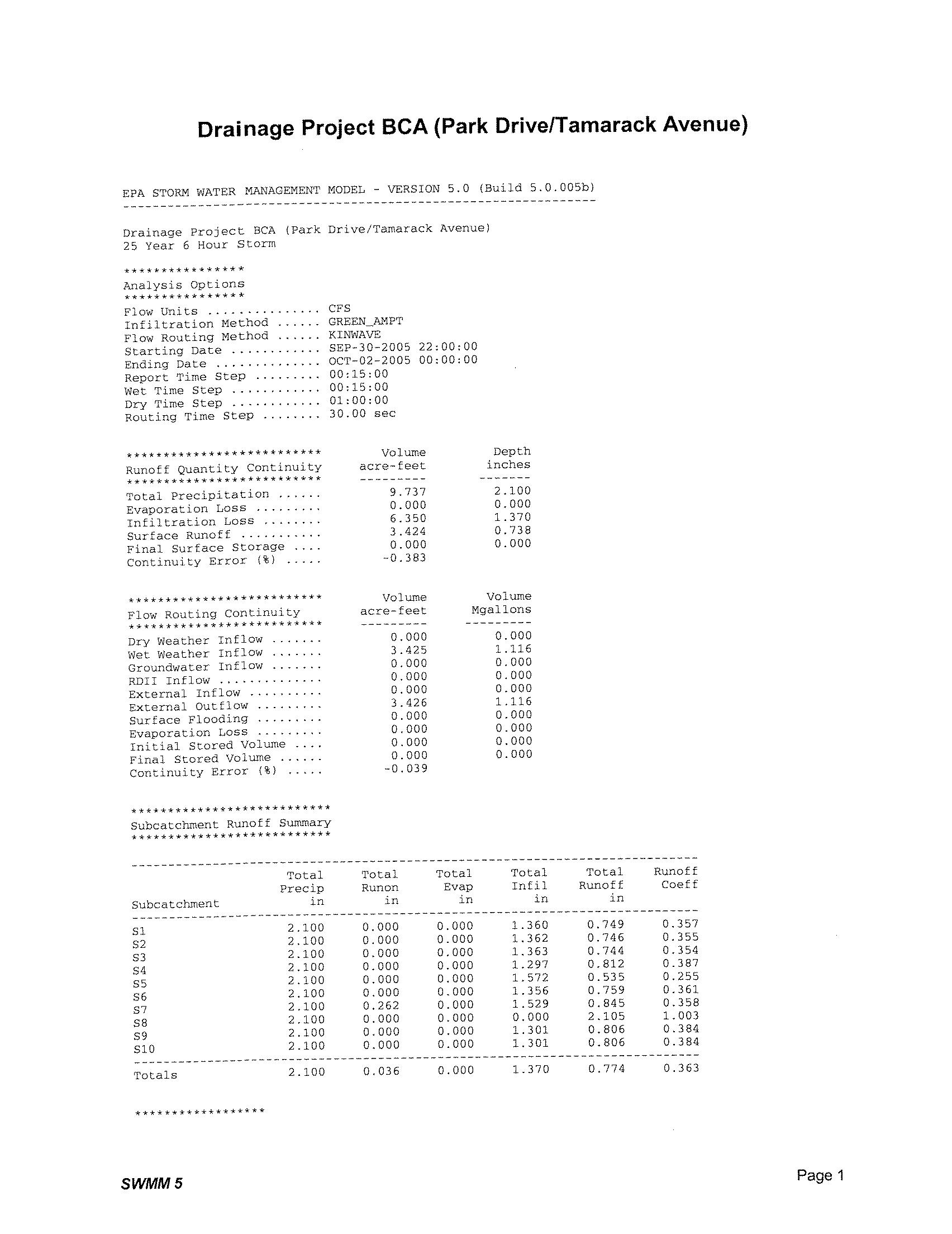


Project BCB Magnolia Avenue Project


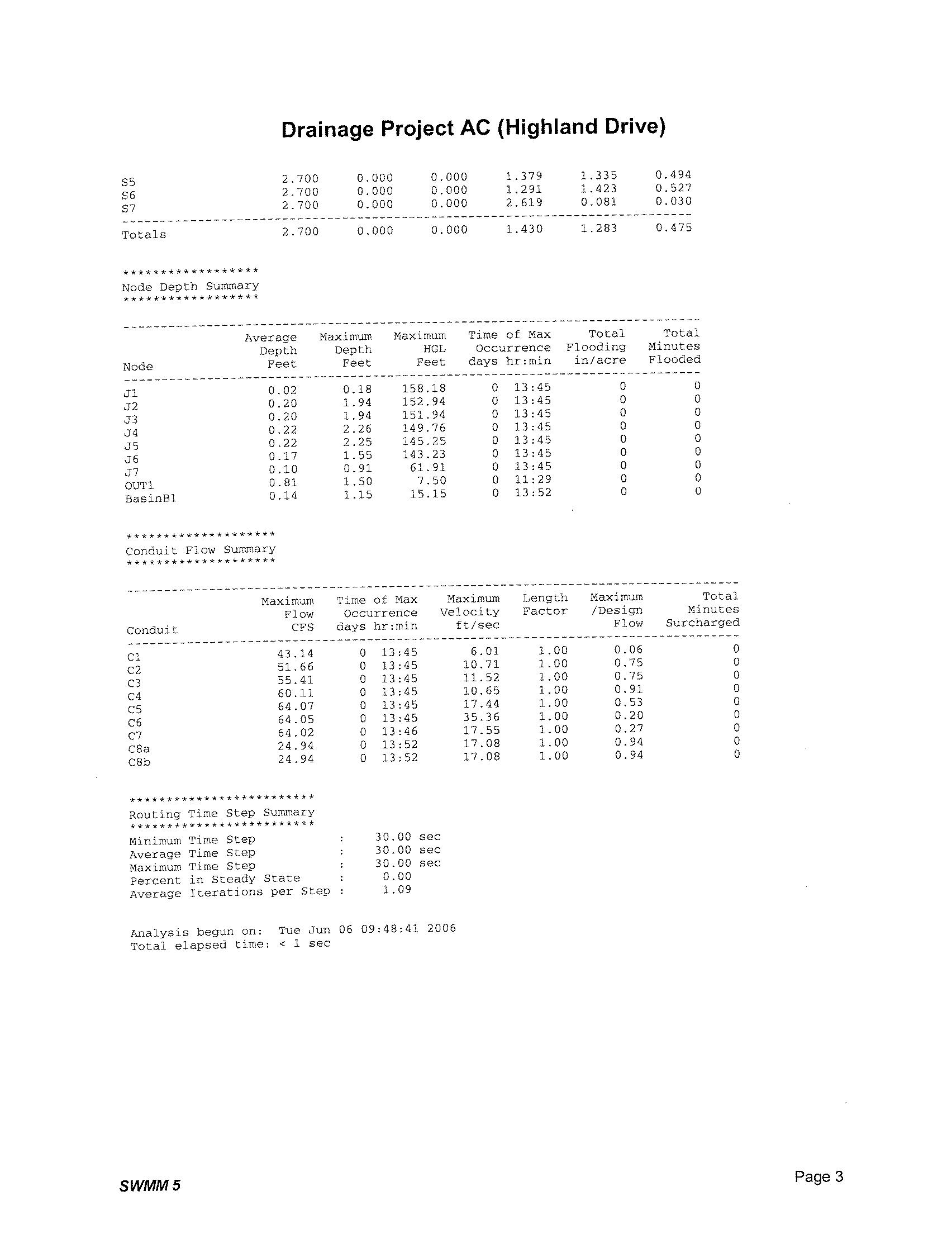


Project BB – 1 Project BB – 2
Washington Street Project
05001,000


Project AC –Highland Drive Project


Project BB 84 INCH
Backwater Check
Washington Street Project
01,000 500 Feet


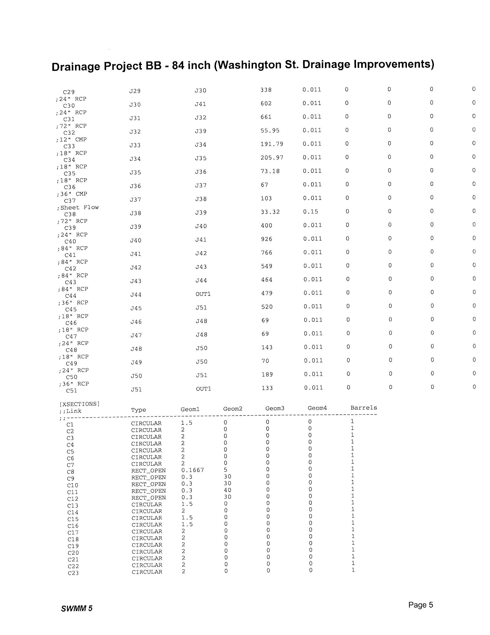
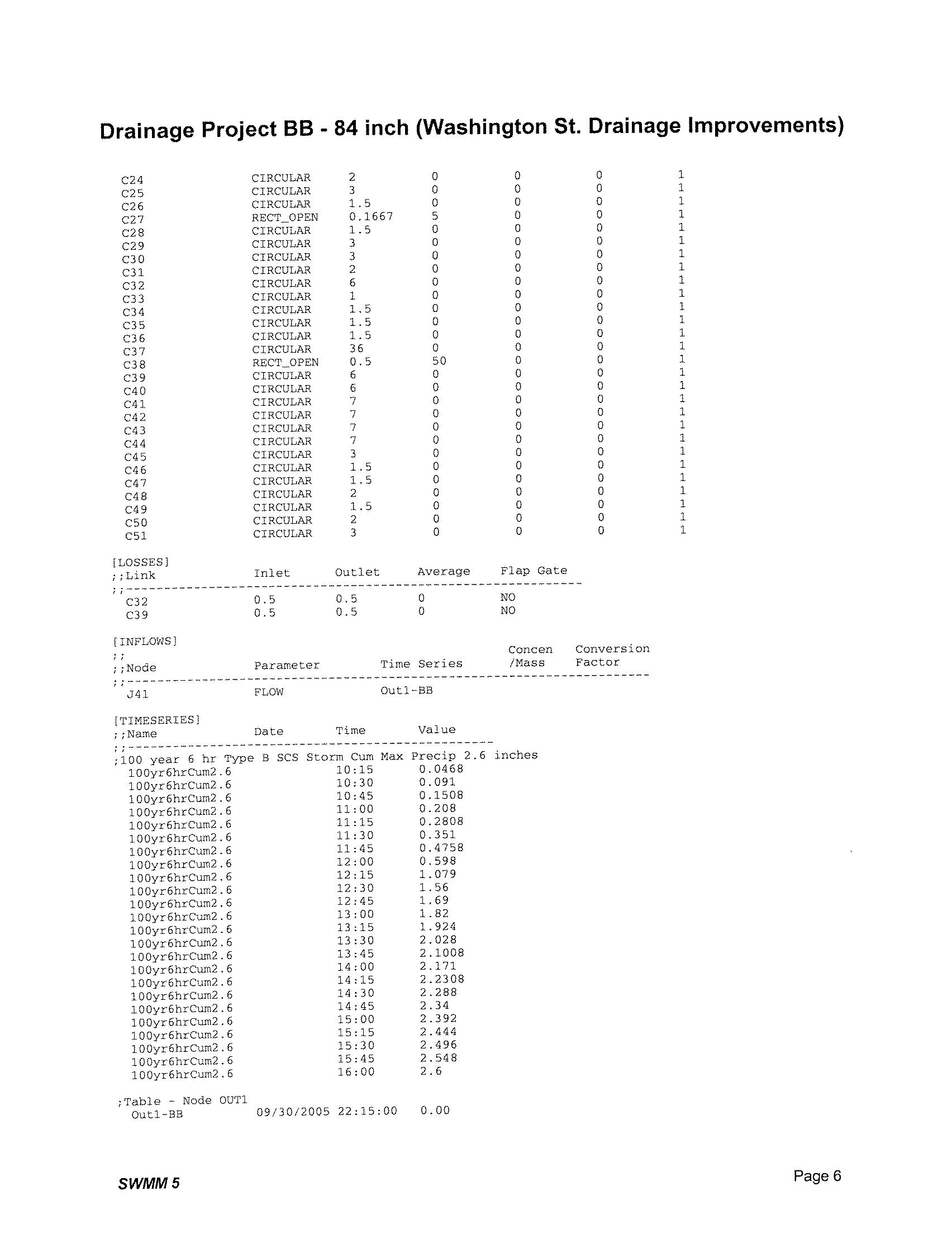


Project BCA


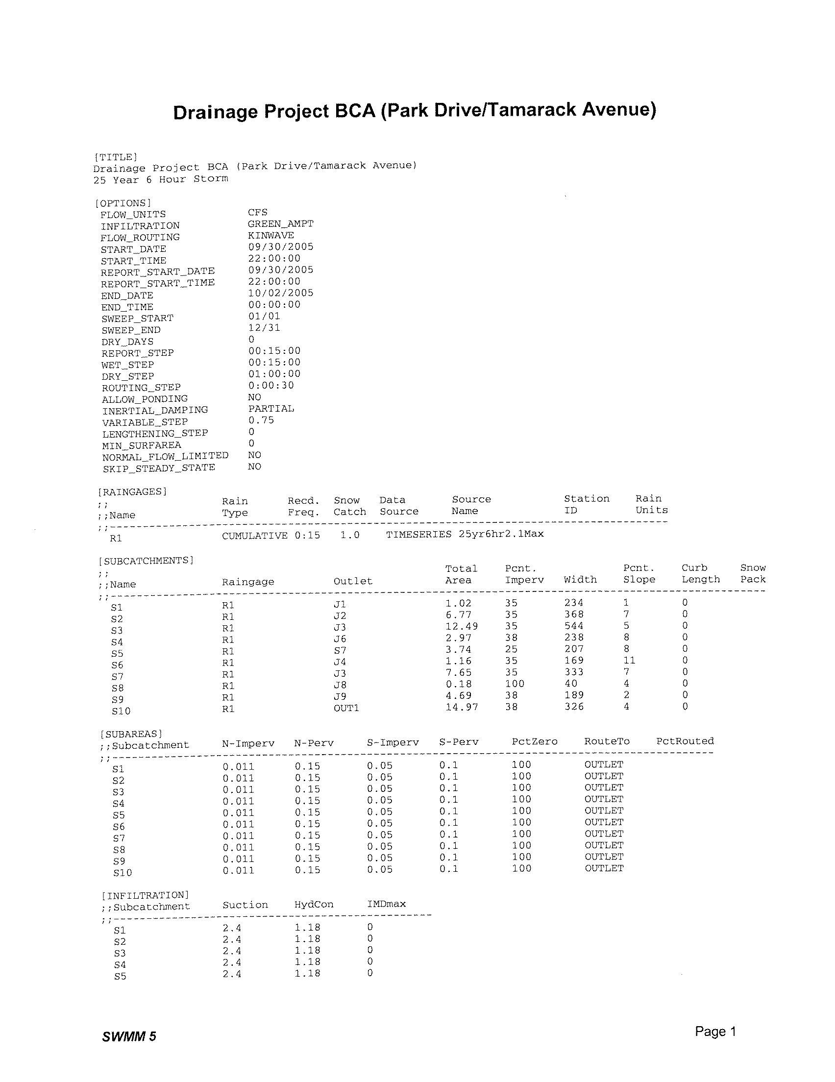


Project BCC Chestnut Avenue Project


05001,000 250 Feet


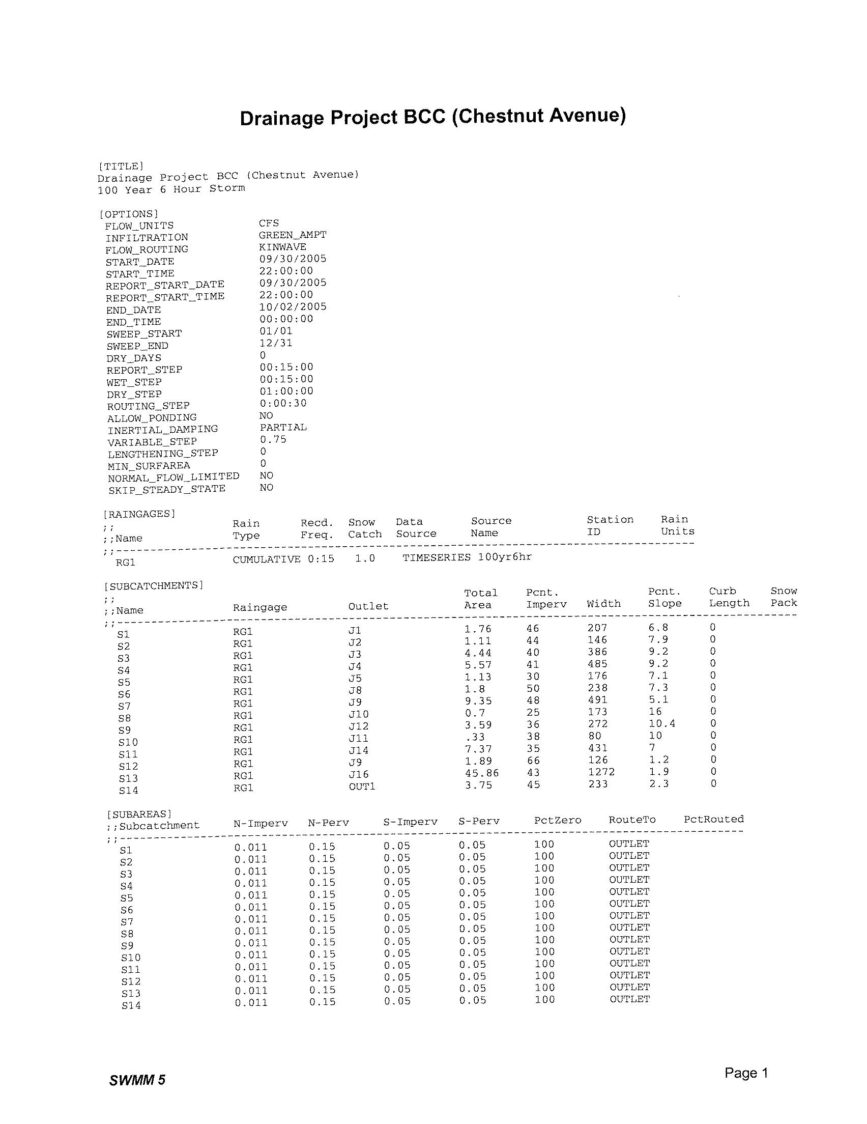


Project C – 1
Carlsbad Boulevard South Project
Project C – 2
Paseo Del Norte Project


PDLA - A
ProjectAAAA90024$218,072$198,428$416,500 ProjectAAA55036$150,293$139,241$289,534 ProjectAC1000&27536&18$561,078$431,835$992,913 ProjectAFA2000Channel$26,837$64,771$91,608 ProjectAFB3600Channel$66,071$97,093$163,164
$1,953,719
PDLA - B
ProjectB3000Channel$1,178,489$952,728$2,131,218 ProjectBB-1110018$176,840$158,793$335,632 ProjectBB-2170036$413,663$336,770$750,433 ProjectBCA290024$590,376$478,237$1,068,613 ProjectBCB92530$256,921$211,175$468,096 ProjectBCC92536$279,735$232,244$511,979 ProjectBFA160042$528,155$435,518$963,673 ProjectBFB-U3800Channel$68,367$69,853$138,220 ProjectBFB-L80048$255,297$236,040$491,336 ProjectBF1N/ASedBasin$223,827$189,156$412,983 ProjectBJ-1270&N/ARCB&SedBasin$276,784$223,735$500,519 ProjectBJBN/AOutletStructure$77,952$75,080$153,032 ProjectBL-U80039$198,775$185,734$384,509 ProjectBL-L20&12590&Bridge$652,887$1,163,214$1,816,101 ProjectBM260RCB$127,624$76,453$204,077 ProjectBNB360084$1,876,136$1,546,690$3,422,826 ProjectBN3600Channel$170,056$186,617$356,673 ProjectBP28&172RCB$191,371$133,963$325,334 ProjectBQ800SpotEnhance$67,164$64,191$131,355 ProjectBR15066$94,281$86,492$180,773 $14,747,382
PDLA - C
ProjectC1100BRIDGE$1,667,416$1,851,100$3,518,516 ProjectC290RCB$259,816$467,915$727,730 ProjectCA600ConcreteChannel$191,064$338,338$529,402 $4,775,649
PDLA - D
ProjectDBA36030$83,448$83,767$167,215 ProjectDBB72030$227,889$201,218$429,108 ProjectDFAN/ATreatmentSystem$109,404$147,019$256,423 ProjectDQB250036$402,175$343,667$745,842 ProjectDH3111SpotEnhance$114,417$118,395$232,812 ProjectDZ100RCB(2)$415,627$226,436$642,063 $2,473,462 $23,950,212

CityofCarlsbad,DrainageMasterPlan
ProjectNumber::128290
Client::CityofCarlsbad
Estimator(s)::SB/DG
EstimatingOffice::WalnutCreek
EstimateIssueNumber::01
EstimateOriginalIssueDate::3/14/2006
EstimateRevisionNumber::04
EstimateRevisionDate::6/27/2008
BCProjectManager::ChrisHerencia
EstimateQA/QCReviewer::ButchMatthews
EstimateQA/QCDate::6/27/2008
PROJECTLOCATION/ITEMDESCRIPTION
ProjectAAA-LocatedinBasinA
01-GENERALREQUIREMENTS
01200-Generalequipmentrental
Trenchbox,7200lbs,6'x20'6Day$0.00$0.00$0.00$0.00$141.60$849.60$141.6/Day$0.00$0.00$849.60 TrenchPlatesallowance1Mo$0.00$0.00$0.00$0.00$900.00$900.00$900/Mo$0.00$0.00$900.00
02-SITECONSTRUCTION
02020-Undergroundmarkingtape
Undergroundtape,detectablealuminum,2''6Clf$2.34$12.87$3.06$16.83$0.00$0.00$5.4/Clf$0.00$0.00$29.70
02060-Sitedemolition
Sitedml,nohauling,pavementremoval,bit,4''to6''thick427Sqyd$5.29$2,258.83$0.00$0.00$3.49$1,490.23$8.78/Sqyd$0.00$0.00$3,749.06
Asphaltdisposal-haulinganddisposalfee,4"thick427Sqyd$1.00$427.00$4.70$2,006.90$1.32$563.64$7.02/Sqyd$0.00$0.00$2,997.54
02170-Sawcutting
Sawcutting,asphalt,upto3''deep1112Lnft$0.48$533.76$0.07$77.84$0.26$289.12$0.81/Lnft$0.00$0.00$900.72
Sawcutting,asphalt,after3''deep;eachaddlinchofdepth1112Lnft$0.82$911.84$0.30$333.60$0.44$489.28$1.56/Lnft$0.00$0.00$1,734.72
02310-Finegrade
Finegradeunderasphalt427Sqyd$0.26$111.02$0.00$0.00$0.21$89.67$0.47/Sqyd$0.00$0.00$200.69
02320-Backfill
Backfill,dozerbackfilling,trench,nocompaction853Cuyd$0.80$682.40$0.00$0.00$1.28$1,091.84$2.08/Cuyd$0.00$0.00$1,774.24
02340-Bedding
Bedding,crushedstone3/4''to1/2''143Cuyd$8.47$1,211.21$32.03$4,580.29$1.89$270.27$42.39/Cuyd$0.00$0.00$6,061.77
02360-Compaction
BackfillCompaction,walkbehind,vibratingroller24''W,6''lifts,2853Cuyd$1.72$1,467.16$0.00$0.00$0.41$349.73$2.13/Cuyd$0.00$0.00$1,816.89
SubgradeCompaction,rammertamper,6''to11'',4''lifts,2passes61Cuyd$2.93$179.02$0.00$0.00$0.78$47.66$3.71/Cuyd$0.00$0.00$226.68 BeddingCompaction,rammertamper,6''to11'',4''lifts,2passes853Cuyd$2.93$2,499.29$0.00$0.00$0.78$665.34$3.71/Cuyd$0.00$0.00$3,164.63
02450-Excavating,trench
Excavatetrench,contftg,noshtordewtrg,4'-6'D,1-1/2CYhydbac1140Cuyd$1.95$2,223.00$0.00$0.00$1.42$1,618.80$3.37/Cuyd$0.00$0.00$3,841.80
02460-Hauling
Hauling,LCY,noloading,12c.y.dumptruck,20MIRT,0.4lds/hr376Cuyd$7.18$2,701.12$3.00$1,128.60$15.45$5,810.89$25.63/Cuyd$0.00$0.00$9,640.61 LoadingTrucks,F.E.Loader,3C.Y..376Cuyd$0.74$278.39$0.00$0.00$1.24$466.49$1.98/Cuyd$0.00$0.00$744.88 Disposalfee19Trk$0.00$0.00$0.00$0.00$0.00$0.00$105/Trk$0.00$1,975.05$1,975.05
02490-Erosioncontrol
Erosioncontrolallowance:smallsite:siltfence,biobags,nospecial1Lsum$0.00$0.00$0.00$0.00$0.00$0.00$1536/Lsum$0.00$1,536.00$1,536.00
02570-Catchbasinsormanholes
Cleanout1Each$1,019.00$1,019.00$1,560.00$1,560.00$249.00$249.00$2828/Each$0.00$0.00$2,828.00 Catchbsnsormanholes,curbinletFR,grate,large24''x36''heavy4Each$602.88$2,411.52$472.04$1,888.16$0.00$0.00$1074.92/Each$0.00$0.00$4,299.68
02600-Basecourse
Basecourse,largeareas,crushed3/4''stone,compactedto9''deep427Sqyd$0.80$341.60$8.06$3,441.62$1.02$435.54$9.88/Sqyd$0.00$0.00$4,218.76
02610-Asphaltconcretepavement
Asphalticconcpavement,pavementreplacementovertrench,4''thick427Sq
02640-Linesonpav't
Linesonpvmt,acrylicwaterborne,whiteoryellow,4''wide550Lnft$0.12$66.00$0.17$93.50$0.08$44.00$0.37/Lnft$0.00$0.00$203.50
02840-Landscaping
TrafficControlAllowance:2flaggers,15'pipe/hr1Lsum$0.00$0.00$0.00$0.00$0.00$0.00$4878/Lsum$0.00$4,878.00$4,878.00
02900-PotHoling
PotHoling-pipelines:2per100'11Each$250.00$2,750.00$0.00$0.00$35.00$385.00$285/Each$0.00$0.00$3,135.00
SITECONSTRUCTIONTotal
15-MECHANICAL
15090-Pipe,drng&sewage,concret
$37,030.03$22,813.34$15,628.96$0.00$8,389.05$83,861.38
Piping,drainage&sewage,RCP,class3,nogaskets,36''dia550Lnft$39.70$21,835.00$73.00$40,150.00$3.94$2,167.00$116.64/Lnft$0.00$0.00$64,152.00
Piping,waterdist,concpipe,gasket,36''dia55Each$3.14$172.70$6.50$357.50$0.00$0.00$9.64/Each$0.00$0.00$530.20 MECHANICALTotal
Grand Total
$22,007.70$40,507.50$2,167.00$0.00$0.00$64,682.20
ProectAAATotal550LF$59,037.73$63,320.84$19,545.56$0.00$8,389.05$150,293.18
$59,037.73$63,320.84$19,545.56$0.00$8,389.05$150,293.18
CityofCarlsbad,DrainageMasterPlan
ProjectNumber::128290
Client::CityofCarlsbad
Estimator(s)::JW/DG
EstimatingOffice::WalnutCreek
EstimateIssueNumber::01
EstimateOriginalIssueDate::3/14/2006
EstimateRevisionNumber::04
EstimateRevisionDate::6/27/2008
BCProjectManager::ChrisHerencia
EstimateQA/QCReviewer::ButchMatthews
EstimateQA/QCDate::6/27/2008
PROJECTLOCATION/PROCESSAREA
ProjectAAAA-LocatedinBasinA
01-GENERALREQUIREMENTS
Trenchbox,7200lbs,6'x20'12Day$0.00$0.00$0.00$0.00$141.60$1,699.20$141.6/Day$0.00$0.00$1,699.20
TrenchPlatesallowance1Mo$0.00$0.00$0.00$0.00$900.00$900.00$900/Mo$0.00$0.00$900.00
02-SITECONSTRUCTION
02020-Undergroundmarkingtape
Undergroundtape,detectablealuminum,2''9Clf$2.34$21.06$3.06$27.54$0.00$0.00$5.4/Clf$0.00$0.00$48.60
02060-Sitedemolition
Sitedml,nohauling,pavementremoval,bit,4''to6''thick600Sqyd$5.29$3,174.00$0.00$0.00$3.49$2,094.00$8.78/Sqyd$0.00$0.00$5,268.00 Asphaltdisposal-haulinganddisposalfee,4"thick600Sqyd$1.00$600.00$4.70$2,820.00$1.32$792.00$7.02/Sqyd$0.00$0.00$4,212.00
02170-Sawcutting
Sawcutting,asphalt,upto3''deep1812Lnft$0.48$869.76$0.07$126.84$0.26$471.12$0.81/Lnft$0.00$0.00$1,467.72
Sawcutting,asphalt,after3''deep;eachaddlinchofdepth1812Lnft$0.82$1,485.84$0.30$543.60$0.44$797.28$1.56/Lnft$0.00$0.00$2,826.72
02310-Finegrade
Finegradeunderasphalt600Sqyd$0.26$156.00$0.00$0.00$0.21$126.00$0.47/Sqyd$0.00$0.00$282.00
02340-Bedding
Bedding,crushedstone3/4''to1/2''421Cuyd$8.47$3,565.02$32.03$13,481.43$1.89$795.50$42.39/Cuyd$0.00$0.00$17,841.95
Importbackfill,crushedstone3/4''to1/2''444Cuyd$8.47$3,764.07$32.03$14,234.13$1.89$839.92$42.39/Cuyd$0.00$0.00$18,838.12
02360-Compaction
SubgradeCompaction,rammertamper,6''to11'',4''lifts,2passes67Cuyd$2.93$195.43$0.00$0.00$0.78$52.03$3.71/Cuyd$0.00$0.00$247.46
BeddingCompaction,rammertamper,6''to11'',4''lifts,2passes362Cuyd$2.93$1,060.66$0.00$0.00$0.78$282.36$3.71/Cuyd$0.00$0.00$1,343.02
02450-Excavating,trench
Excavatetrench,contftg,noshtordewtrg,4'-6'D,1-1/2CYhydbac867Cuyd$1.95$1,690.65$0.00$0.00$1.42$1,231.14$3.37/Cuyd$0.00$0.00$2,921.79
02460-Hauling
Hauling,LCY,noloading,12c.y.dumptruck,20MI867Cuyd$7.18$6,225.06$3.00$2,601.00$15.45$13,392.00$25.63/Cuyd$0.00$0.00$22,218.06
LoadingTrucks,F.E.Loader,3C.Y..867Cuyd$0.74$641.58$0.00$0.00$1.24$1,075.08$1.98/Cuyd$0.00$0.00$1,716.66
Disposalfee43Trk$0.00$0.00$0.00$0.00$0.00$0.00$105/Trk$0.00$4,551.75$4,551.75
02490-Erosioncontrol
Erosioncontrolallowance:smallsite:siltfence,biobags,nospecial1Lsum$0.00$0.00$0.00$0.00$0.00$0.00$1536/Lsum$0.00$1,536.00$1,536.00
02570-Catchbasinsormanholes
CBormanholes,conc,precast,4'ID,6'deep3Each$549.75$1,649.25$1,050.00$3,150.00$148.32$444.96$1748.07/Each$0.00$0.00$5,244.21
Junctionstructuremanholes,concrete,precast,8'I.D.,8'deep,1Each$1,587.50$1,587.50$3,133.31$3,133.31$354.40$354.40$5075.21/Each$0.00$0.00$5,075.21
CBormanholes,conc,slabtops,precast,8''thick,4'dia3Each$158.75$476.25$201.00$603.00$35.44$106.32$395.19/Each$0.00$0.00$1,185.57 Cleanout2Each$1,019.00$2,038.00$1,560.00$3,120.00$249.00$498.00$2828/Each$0.00$0.00$5,656.00
CBormanholes,conc,slabtops,precast,8''thick,8'dia1Each$181.43$181.43$575.00$575.00$40.50$40.50$796.93/Each$0.00$0.00$796.93 Catchbsnsormanholes,frsandcovs,hvytraffic,24''diam,400lb.3Each$162.82$488.46$260.00$780.00$36.35$109.05$459.17/Each$0.00$0.00$1,377.51 Catchbsnsormanholes,frsandcovs,hvytraffic,36''diam,1150lb.1Each$423.33$423.33$860.00$860.00$94.51$94.51$1377.84/Each$0.00$0.00$1,377.84 CBormanholes,inverts,singlechannelbrick,concrete3Each$144.00$432.00$100.00$300.00$0.00$0.00$244/Each$0.00$0.00$732.00 CBormanholes,inverts,triplechannel,conc1Each$240.32$240.32$134.00$134.00$0.00$0.00$374.32/Each$0.00$0.00$374.32 CB/manholes,steps,heavyweightcastiron,12''x10-1/2'',forallcon6Each$9.66$57.96$23.00$138.00$0.00$0.00$32.66/Each$0.00$0.00$195.96
02600-Basecourse
Basecourse,largeareas,crushed3/4''stone,compactedto9''deep600Sqyd$0.80$480.00$8.06$4,836.00$1.02$612.00$9.88/Sqy
02610-Asphaltconcretepavement
Asphalticconcpavement,pavementreplacementovertrench,4''thick600Sqyd$35.00$21,000.00$18.00$10,800.00$2.98$1,788.00$55.98/Sqy
02640-Linesonpav't
Linesonpvmt,acrylicwaterborne,whiteoryellow,4''wide900Lnft$0.12$108.00$0.17$153.00$0.08$72.00$0.37/Lnft$0.00$0.00$333.00
02840-Landscaping
TrafficControlAllowance:2flaggers,15'pipe/hr1Lsum$0.00$0.00$0.00$0.00$0.00$0.00$4878/Lsum$0.00$4,878.00$4,878.00
02900-PotHoling
PotHoling-pipelines:2per100'18Each$250.00$4,500.00$0.00$0.00$35.00$630.00$285/Each$0.00$0.00$5,130.00
SITECONSTRUCTIONTotal
03-CONCRETE
03330-Patchingconcrete
$57,111.63$62,416.85$26,698.16$0.00$10,965.75$157,192.39
Pre-castconcretewallpenetration,non-shrinkgrout,24''hole8Each$75.00$600.00$108.00$864.00$0.00$0.00$183/Each$0.00$0.00$1,464.00
15-MECHANICAL
15090-Pipe,drng&sewage,concret
Piping,drainage&sewage,RCP,class3,nogaskets,24''dia900Lnft$24.50$22,050.00$35.00$31,500.00$2.84$2,556.00$62.34/Lnft$0.00$0.00$56,106.00
Piping,waterdist,concpipe,gasket,24''dia90Each$3.14$282.60$4.75$427.50$0.00$0.00$7.89/Each$0.00$0.00$710.10 MECHANICALTotal
Grand Total
$22,332.60$31,927.50$2,556.00$0.00$0.00$56,816.10
ProectAAAATotal$80,044.23$95,208.35$31,853.36$0.00$10,965.75$218,071.69
$80,044.23$95,208.35$31,853.36$0.00$10,965.75$218,071.69
CityofCarlsbad,DrainageMasterPlan
ProjectNumber::128290
Client::CityofCarlsbad
Estimator(s)::JW/DG
EstimatingOffice::WalnutCreek
EstimateIssueNumber::01
EstimateOriginalIssueDate::3/14/2006
EstimateRevisionNumber::04
EstimateRevisionDate::6/27/2008
BCProjectManager::ChrisHerencia
EstimateQA/QCReviewer::ButchMatthews
EstimateQA/QCDate::6/27/2008
PROJECTLOCATION/PROCESSAREA
ProjectAC-LocatedinBasinA
01-GENERALREQUIREMENTS
01200-Generalequipmentrental
Trenchbox,9500lbs,8'x20'20Day$0.00$0.00$0.00$0.00$240.00$4,800.00$240/Da
02-SITECONSTRUCTION
02020-Undergroundmarkingtape
Undergroundtape,detectablealuminum,2''13Clf$2.34$29.84$3.06$39.02$0.00$0.00$5.4/Clf$0.00$0.00$68.85
02060-Sitedemolition
Sitedml,nohauling,pavementremoval,bit,4''to6''thick436Sqyd$5.29$2,305.54$0.00$0.00$3.49$1,521.05$8.78/Sqyd$0.00$0.00$3,826.59 Asphaltdisposal-haulinganddisposalfee,4"thick436Sqyd$1.00$435.83$4.70$2,048.40$1.32$575.30$7.02/Sqyd$0.00$0.00$3,059.53
02170-Sawcutting
Sawcutting,asphalt,upto3''deep2280Lnft$0.48$1,094.40$0.07$159.60$0.26$592.80$0.81/Lnft$0.00$0.00$1,846.80
Sawcutting,asphalt,after3''deep;eachaddlinchofdepth2280Lnft$0.82$1,869.60$0.30$684.00$0.44$1,003.20$1.56/Lnft$0.00$0.00$3,556.80
02320-Backfill
Backfill,dozerbackfilling,trench,upto300'haul,nocompaction1568Cuyd$0.80$1,254.32$0.00$0.00$1.28$2,006.91$2.08/Cuyd$0.00$0.00$3,261.23
Backfill,dozerbackfilling,trench,upto300'haul,nocompaction,391Cuyd$0.80$312.80$0.00$0.00$1.28$500.48$2.08/Cuyd$0.00$0.00$813.28
02340-Bedding
Bedding,crushedstone3/4''to1/2''962Cuyd$8.47$8,146.45$32.03$30,806.45$1.89$1,817.80$42.39/Cuyd$0.00$0.00$40,770.70
02360-Compaction
Compaction,trench,walkbehind,vib.plate,bedding827Cuyd$1.90$1,571.49$0.00$0.00$0.51$421.82$2.41/Cuyd$0.00$0.00$1,993.31 Compaction,trench,walkbehind,vib.plate,subgrade129Cuyd$1.90$244.91$0.00$0.00$0.51$65.74$2.41/Cuyd$0.00$0.00$310.65
Compaction,trench,walkbehind,vib.plate,backfill1411Cuyd$1.90$2,681.09$0.00$0.00$0.51$719.66$2.41/Cuyd$0.00$0.00$3,400.75
Compaction,struct.ortrench,walkbehind,vib.platesubgrade111Cuyd$1.90$210.90$0.00$0.00$0.51$56.61$2.41/Cuyd$0.00$0.00$267.51
Compaction,struct.ortrench,walkbehind,vib.platebedding167Cuyd$1.90$317.30$0.00$0.00$0.51$85.17$2.41/Cuyd$0.00$0.00$402.47
Compaction,struct.ortrench,walkbehind,vib.platebackfillchannel391Cuyd$1.90$742.90$0.00$0.00$0.51$199.41$2.41/Cuyd$0.00$0.00$942.31
02420-Excavating,structural
Excavating,structural,machexcav,comearth,hydbackhoe,2CY890Cuyd$5.28$4,699.20$0.00$0.00$6.70$5,963.00$11.98/Cuyd$0.00$0.00$10,662.20
02450-Excavating,trench
Excavatetrench,noshtordewtrg,4'-6'D,1-1/2CYhydbac2518Cuyd$1.95$4,910.30$0.00$0.00$1.42$3,575.70$3.37/Cuyd$0.00$0.00$8,486.00
02460-Hauling
Hauling,LCY,noloading,20c.y.dumptruck,30MIRT,0.33lds/hr1580Cuyd$5.95$9,398.62$0.00$0.00$10.40$16,427.84$16.35/Cuyd$0.00$0.00$25,826.46
Hauling,LCY,noloading,20c.y.dumptruck,20MIRT,0.4lds/hr,499Cuyd$5.95$2,969.05$0.00$0.00$10.40$5,189.60$16.35/Cuyd$0.00$0.00$8,158.65
LoadingTrucks,F.E.Loader,3C.Y..1580Cuyd$0.74$1,168.90$0.00$0.00$1.24$1,958.70$1.98/Cuyd$0.00$0.00$3,127.61
LoadingTrucks,F.E.Loader,3C.Y..,channel499Cuyd$0.74$369.26$0.00$0.00$1.24$618.76$1.98/Cuyd$0.00$0.00$988.02
02570-Catchbasinsormanholes
Catchbasinsormanholes,concrete,precast,6'I.D.,6'deep6Each$846.67$5,080.02$1,850.00$11,100.00$189.01$1,134.06$2885.68/Each$0.00$0.00$17,314.08
02610-Asphaltconcretepavement
Asphalticconcpavement,pavementreplacementovertrench,4''436Sq
03-CONCRETE
03090-Formsplace,slabgrade
Formsinplace,SOG,edgeforms,7''to12''high,wood,channel1216Sfca$3.99$4,851.84$0.80$972.80$0.00$0.00$4.79/Sfca$0.00$0.00$5,824.64
03110-Formsinplace,walls
Formsinplace,walls,jobbuiltplyform,to8'high,channel2400Sfca$7.35$17,640.00$2.59$6,216.00$0.00$0.00$9.94/Sfca$0.00$0.00$23,856.00
03140-Weldedwirefabric
Weldedwirefabric,sheets,4x4-W4xW4(4x4),85lb/CSF,54Csf$36.61$1,976.94$29.41$1,588.14$0.00$0.00$66.02/Csf$0.00$0.00$3,565.08
Weldedwirefabric,sheets,4x4-W4xW4(4x4),85lb/CSF,12Csf$36.61$439.32$29.41$352.92$0.00$0.00$66.02/Csf$0.00$0.00$792.24
03150-Concrete,readymix
Headwall195Cuyd$0.00$0.00$0.00$0.00$0.00$0.00$1000/Cuyd$0.00$195,000.00$195,000.00
Concrete,readymix,regularweight,4000psi104Cuyd$0.00$0.00$120.00$12,480.00$0.00$0.00$120/Cuyd$0.00$0.00$12,480.00
03170-Placingconcrete
Placingconc,inclvib,slabongrade,pumped,channel59Cuyd$17.45$1,029.55$0.00$0.00$5.56$328.04$23.01/Cuyd$0.00$0.00$1,357.59
Placingconc,inclvib,walls,pumped,channel45Cuyd$32.28$1,452.60$0.00$0.00$10.28$462.60$42.56/Cuyd$0.00$0.00$1,915.20
03180-Finishingfloors
Finishingslabs,breakties,forms&patchvoids1216Sqft$1.17$1,422.72$0.03$36.48$0.00$0.00$1.2/Sqft$0.00$0.00$1,459.20
Finishingfloors,monolithic,screed,float,&handtrowel,channel4800Sqft$0.62$2,976.00$0.00$0.00$0.00$0.00$0.62/Sqft$0.00$0.00$2,976.00
03190-Finishingwalls
Finishingslabs,breakties,forms&patchvoids2400Sqft$1.17$2,808.00$0.03$72.00$0.00$0.00$1.2/Sqft$0.00$0.00$2,880.00
Finishingwalls,carborundumrub,wetrub1200Sqft$2.13$2,556.00$0.03$36.00$0.00$0.00$2.16/Sqft$0.00$0.00$2,592.00
15-MECHANICAL
15090-Pipe,drng&sewage,concret
Piping,drainage&sewage,RCP,class3,nogaskets,18''dia275Lnft$18.85$5,183.75$32.00$8,800.00$2.18$599.50$53.03/Lnft$0.00$0.00$14,583.25
Piping,drainage&sewage,RCP,class3,nogaskets,36''dia1000Lnft$39.70$39,700.00$73.00$73,000.00$3.94$3,940.00$116.64/Lnft$0.00$0.00$116,640.00
15395-Cleanouts
Cleanouts,flrtype,rndtop,xtrahvydty,36''pipesize3Each$791.91$2,375.73$1,500.00$4,500.00$0.00$0.00$2291.91/Each$0.00$0.00$6,875.73
ProjectACTotal$149,479.21$160,736.75$55,862.53$0.00$195,000.00$561,078.49
Grand Total $149,479.21$160,736.75$55,862.53$0.00$195,000.00$561,078.49
CityofCarlsbad,MasterDrainagePlan
ProjectNumber::128290
Client::CityofCarlsbad
Estimator(s)::SB/DG
EstimatingOffice::WalnutCreek
EstimateIssueNumber::01
EstimateOriginalIssueDate::11/14/1005
EstimateRevisionNumber::04
EstimateRevisionDate::6/27/2008
BCProjectManager::ChrisHerencia
EstimateQA/QCReviewer::ButchMatthews
EstimateQA/QCDate::6/27/2008
PROJECTLOCATION/PROCESSAREA
ProjectAFA-LocatedinBasinA
02-SITECONSTRUCTION
02210-Clearandgrub
Clear&grub,brush,includingstumps0Acre$1,759.00$703.60$0.00$0.00$3,686.00$1,474.40$5445/Acre$0.00$0.00$2,178.00
02420-Excavating
Excavation,selfpropscraper,14CY1/4pushdozer500Cuyd$1.29$645.00$0.00$0.00$5.19$2,595.00$6.48/Cuyd$0.00$0.00$3,240.00
02360-Compaction
Compaction,walkbehind,vibratingpl18''w,12''lifts,4passes,593Cuyd$1.90$1,126.70$0.00$0.00$0.51$302.43$2.41/Cuyd$0.00$0.00$1,429.13
02460-Hauling
Fill,spreaddumpedmaterial,bydozer,nocompaction593Cuyd$0.72$426.96$0.00$0.00$1.15$681.95$1.87/Cuyd$0.00$0.00$1,108.91
02470-Soilstabilization
Soilstabilization,geotextilefabric,woven,H.D.,600lb.tensilest1646Sqyd$0.32$526.72$1.85$3,045.10$0.00$0.00$2.17/Sqyd$0.00$0.00$3,571.82
02480-Rip-rap
Rip-rap,gabions,galvsteelmeshboxes,stonefilled,36''deep100Cuyd$49.95$4,995.00$60.56$6,056.00$16.44$1,644.00$126.95/Cuyd$0.00$0.00$12,695.00
02490-Erosioncontrol
Erosioncontrolallowance:1Lsum$0.00$0.00$0.00$0.00$0.00$0.00$2614/Lsum$0.00$2,614.00$2,614.00
SITECONSTRUCTIONTotal
Grand Total
$8,423.98$9,101.10$6,697.78$0.00$2,614.00$26,836.86
ProjectAFATotal$8,423.98$9,101.10$6,697.78$0.00$2,614.00$26,836.86
$8,423.98$9,101.10$6,697.78$0.00$2,614.00$26,836.86
CityofCarlsbad,MasterDrainagePlan
ProjectNumber::128290
Client::CityofCarlsbad
Estimator(s)::SB/DG
EstimatingOffice::WalnutCreek
EstimateIssueNumber::01
EstimateOriginalIssueDate::11/14/2005
EstimateRevisionNumber::04
EstimateRevisionDate::6/27/2008
BCProjectManager::ChrisHerencia
EstimateQA/QCReviewer::ButchMatthews
EstimateQA/QCDate::6/27/2008
PROJECTLOCATION/PROCESSAREA
ProjectAFB-LocatedinBasinA
02-SITECONSTRUCTION
02210-Clearandgrub
Clear&grub,brush,includingstumps1Acre$1,759.00$1,055.40$0.00$0.00$3,686.00$2,211.60$5445/Acre$0.00$0.00$3,267.00
02420-Excavating
Excavation,selfpropscraper,14CY1/4pushdozer1500Cuyd$1.29$1,935.00$0.00$0.00$5.19$7,785.00$6.48/Cuyd$0.00$0.00$9,720.00
02360-Compaction
Compaction,walkbehind,vibratingpl18''w,12''lifts,4passes,1650Cuyd$1.90$3,135.00$0.00$0.00$0.51$841.50$2.41/Cuyd$0.00$0.00$3,976.50
02460-Hauling
Disposalfee53Trk$0.00$0.00$0.00$0.00$0.00$0.00$105/Trk$0.00$5,601.75$5,601.75
Hauling,LCY,noloading,12CYdumptruck,clear&grub1067Cuyd$4.66$4,972.22$0.00$0.00$9.74$10,392.58$14.4/Cuyd$0.00$0.00$15,364.80
LoadingTrucks,F.E.Loader,3C.Y..,clear&grub1067Cuyd$0.74$789.58$0.00$0.00$1.24$1,323.08$1.98/Cuyd$0.00$0.00$2,112.66
Fill,spreaddumpedmaterial,bydozer,nocompaction1650Cuyd$0.72$1,188.00$0.00$0.00$1.15$1,897.50$1.87/Cuyd$0.00$0.00$3,085.50
02470-Soilstabilization
Soilstabilization,geotextilefabric,woven,H.D.,600lb.tensilest1646Sqyd$0.32$526.72$1.85$3,045.10$0.00$0.00$2.17/Sqyd$0.00$0.00$3,571.82
02480-Rip-rap
Rip-rap,gabions,galvsteelmeshboxes,stonefilled,36''deep132Cuyd$49.95$6,593.40$60.56$7,993.92$16.44$2,170.08$126.95/Cuyd$0.00$0.00$16,757.40
02490-Erosioncontrol
Erosioncontrolallowance:1Lsum$0.00$0.00$0.00$0.00$0.00$0.00$2614/Lsum$0.00$2,614.00$2,614.00
SITECONSTRUCTIONTotal
Grand Total
$20,195.32$11,039.02$26,621.34$0.00$8,215.75$66,071.43
ProjectAFBTotal$20,195.32$11,039.02$26,621.34$0.00$8,215.75$66,071.43
$20,195.32$11,039.02$26,621.34$0.00$8,215.75$66,071.43
CityofCarlsbad,DrainageMasterPlan
ProjectNumber::128290
Client::CityofCarlsbad
Estimator(s)::SB/DG
EstimatingOffice::WalnutCreek
EstimateIssueNumber::01
EstimateOriginalIssueDate::5/12/2006
EstimateRevisionNumber::04
EstimateRevisionDate::6/27/2008
BCProjectManager::ChrisHerencia
EstimateQA/QCReviewer::BobFerguson
EstimateQA/QCDate::6/27/2008
PROJECTLOCATION/PROCESSAREA
ProjectB-LocatedinBasinB
ProjectB 02-SITECONSTRUCTION
02060-Sitedemolition
Sitedml,conc7''to24''thick,rodreinforced25Cuyd$92.56$2,314.00$0.00$0.00$61.09$1,527.25$153.65/Cuyd$0.00$0.00$3,841.25
02210-Clearandgrub
Clear&grub,brush,includingstumps2Acre$1,759.00$3,518.00$0.00$0.00$3,686.00$7,372.00$5445/Acre$0.00$0.00$10,890.00
02420-Excavating,structural
Excavating,structural,machexcav,comearth,hydbackhoe,3CY36000Cuyd$5.28$190,080.00$0.00$0.00$6.70$241,200.00$11.98/Cuyd$0.00$0.00$431,280.00
Excavating,structural,machexcav,comearth,hydbackhoe,3CY1000Cuyd$5.28$5,280.00$0.00$0.00$6.70$6,700.00$11.98/Cuyd$0.00$0.00$11,980.00
02430-Fill
Fill,spreaddumpedmaterial,bydozer,nocompaction1400Cuyd$0.72$1,008.00$0.00$0.00$1.15$1,610.00$1.87/Cuyd$0.00$0.00$2,618.00
02460-Hauling
Disposalfee2Trk$0.00$0.00$0.00$0.00$0.00$0.00$105/Trk$0.00$210.00$210.00
Hauling,LCY,noloading,20c.y.dumptruck,30MIRT,0.33lds/hr,25Cuyd$5.95$148.75$0.00$0.00$10.40$260.00$16.35/Cuyd$0.00$0.00$408.75
Hauling,LCY,noloading,20c.y.dumptruck,30MIRT,0.33lds/hr30000Cuyd$5.95$178,500.00$0.00$0.00$10.40$312,000.00$16.35/Cuyd$0.00$0.00$490,500.00
Hauling,LCY,noloading,20c.y.dumptruck,30MIRT,0.33lds/hr2456Cuyd$5.95$14,613.20$0.00$0.00$10.40$25,542.40$16.35/Cuyd$0.00$0.00$40,155.60
Hauling,LCY,noloading,20c.y.dumptruck,30MIRT,0.33lds/hr1400Cuyd$5.95$8,330.00$0.00$0.00$10.40$14,560.00$16.35/Cuyd$0.00$0.00$22,890.00
LoadingTrucks,F.E.Loader,3C.Y..26000Cuyd$0.74$19,240.00$0.00$0.00$1.24$32,240.00$1.98/Cuyd$0.00$0.00$51,480.00
LoadingTrucks,F.E.Loader,3C.Y..,concrete23Cuyd$0.74$17.02$0.00$0.00$1.24$28.52$1.98/Cuyd$0.00$0.00$45.54
LoadingTrucks,F.E.Loader,3C.Y..1400Cuyd$0.74$1,036.00$0.00$0.00$1.24$1,736.00$1.98/Cuyd$0.00$0.00$2,772.00
LoadingTrucks,F.E.Loader,3C.Y..2456Cuyd$0.74$1,817.44$0.00$0.00$1.24$3,045.44$1.98/Cuyd$0.00$0.00$4,862.88
02470-Soilstabilization
Soilstabilization,geotextilefabric,woven,H.D.,600lb.tensilest507Sqyd$0.32$162.24$1.85$937.95$0.00$0.00$2.17/Sqyd$0.00$0.00$1,100.19
02480-Rip-rap
Rip-rap,gabions,galvsteelmeshboxes,stonefilled,36''deep618Cuyd$49.95$30,869.10$60.56$37,426.08$16.44$10,159.92$126.95/Cuyd$0.00$0.00$78,455.10
SITECONSTRUCTIONTotal$456,933.75$38,364.03$657,981.53$0.00$210.00$1,153,489.31
03-CONCRETE
03150-Concrete,readymix
Retainingwall25Cuyd$0.00$0.00$0.00$0.00$0.00$0.00$1000/Cuyd$0.00$25,000.00$25,000.00
CONCRETETotal$0.00$0.00$0.00$0.00$25,000.00$25,000.00 ProjectBTotal$456,933.75$38,364.03$657,981.53$0.00$25,210.00$1,178,489.31
Grand Total $456,933.75$38,364.03$657,981.53$0.00$25,210.00$1,178,489.31
Subtotal$1,420,572
CityofCarlsbad,MasterDrainagePlan
ProjectNumber::128290
Client::CityofCarlsbad
Estimator(s)::JW/DG
EstimatingOffice::WalnutCreek
EstimateIssueNumber::01
EstimateOriginalIssueDate::3/14/2006
EstimateRevisionNumber::04
EstimateRevisionDate::6/27/2008
BCProjectManager::ChrisHerencia
EstimateQA/QCReviewer::BobFerguson
EstimateQA/QCDate::6/27/2008
PROJECTLOCATION/PROCESSAREA
ProjectBB-1
ProjectBB-1
01-GENERALREQUIREMENTS
01200-Generalequipmentrental
Trenchbox,7200lbs,6'x20'25Day$0.00$0.00$0.00$0.00$141.60$3,540.00$141.6/Day$0.00$0.00$3,540.00 TrenchPlatesallowance1Mo$0.00$0.00$0.00$0.00$900.00$900.00$900/Mo$0.00$0.00$900.00 GENERALREQUIREMENTSTota $0.00$0.00$4,440.00$0.00$0.00$4,440.00
02-SITECONSTRUCTION
02020-Undergroundmarkingtape
Undergroundtape,detectablealuminum,2''11Clf$2.34$25.74$3.06$33.66$0.00$0.00$5.4/Clf$0.00$0.00$59.40
02060-Sitedemolition
Sitedml,nohauling,pavementremoval,bit,4''to6''thick672Sqyd$5.29$3,554.88$0.00$0.00$3.49$2,345.28$8.78/Sqyd$0.00$0.00$5,900.16 Asphaltdisposal-haulinganddisposalfee,4"thick672Sqyd$1.00$672.00$4.70$3,158.40$1.32$887.04$7.02/Sqyd$0.00$0.00$4,717.44
02170-Sawcutting
Sawcutting,asphalt,upto3''deep2211Lnft$0.48$1,061.28$0.07$154.77$0.26$574.86$0.81/Lnft$0.00$0.00$1,790.91
Sawcutting,asphalt,after3''deep;eachaddlinchofdepth2211Lnft$0.82$1,813.02$0.30$663.30$0.44$972.84$1.56/Lnft$0.00$0.00$3,449.16
02310-Finegrade
Finegrade,finegradegranularbaseforsidewalksandbikeways100Sqyd$1.06$106.00$0.00$0.00$0.15$15.00$1.21/Sqyd$0.00$0.00$121.00
02320-Backfill
Backfill,dozerbackfilling,trench,nocompaction1160Cuyd$0.80$928.00$0.00$0.00$1.28$1,484.80$2.08/Cuyd$0.00$0.00$2,412.80
02340-Bedding
Bedding,crushedstone3/4''to1/2''224Cuyd$8.47$1,897.28$32.03$7,174.72$1.89$423.36$42.39/Cuyd$0.00$0.00$9,495.36
02360-Compaction
Compaction,walkbehind,vibratingroller24''W,6''lifts,2passes1160Cuyd$1.90$2,204.00$0.00$0.00$0.51$591.60$2.41/Cuyd$0.00$0.00$2,795.60
Compaction,rammertamper,6''to11'',4''lifts,2passes1160Cuyd$2.93$3,398.80$0.00$0.00$0.78$904.80$3.71/Cuyd$0.00$0.00$4,303.60
02450-Excavating,trench
Excavatetrench,contftg,noshtordewtrg,4'-6'D,1-1/2CYhydbac1456Cuyd$1.95$2,839.20$0.00$0.00$1.42$2,067.52$3.37/Cuyd$0.00$0.00$4,906.72
02460-Hauling
Hauling,LCY,noloading,20c.y.dumptruck,30MIRT,0.33lds/hr296Cuyd$5.95$1,761.20$0.00$0.00$10.40$3,078.40$16.35/Cuyd$0.00$0.00$4,839.60 LoadingTrucks,F.E.Loader,3C.Y..296Cuyd$0.74$219.04$0.00$0.00$1.24$367.04$1.98/Cuyd$0.00$0.00$586.08
Disposalfee15Trk$0.00$0.00$0.00$0.00$0.00$0.00$105/Trk$0.00$1,575.00$1,575.00 02490-Erosioncontrol
Erosioncontrolallowance:1Lsum$0.00$0.00$0.00$0.00$0.00$0.00$2614/Lsum$0.00$2,614.00$2,614.00 02570-Catchbasinsormanholes
Cleanout2Each$1,019.00$2,038.00$1,560.00$3,120.00$249.00$498.00$2828/Each$0.00$0.00$5,656.00 Catchbsnsormanholes,curbinletFR,grate,large24''x36''heavy2Each$602.88$1,205.76$472.04$944.08$0.00$0.00$1074.92/Each$0.00$0.00$2,149.84 JunctionStructure1Each$680.00$680.00$6,000.00$6,000.00$0.00$0.00$6680/Each$0.00$0.00$6,680.00
02610-Asphaltconcretepavement
Asphalticconcpavement,pavementreplacementovertrench,4''672Sqyd$35.00$23,520.00$18.00$12,096.00$2.98$2,002.56$55.98/Sqyd$0.00$0.00$37,618.56
02640-Linesonpav't
Linesonpvmt,acrylicwaterborne,whiteoryellow,4''wide1100Lnft$0.12$132.00$0.17$187.00$0.08$88.00$0.37/Lnft$0.00$0.00$407.00
02840-Landscaping
TrafficControlAllowance:2flaggers,15'pipe/hr1Lsum$0.00$0.00$0.00$0.00$0.00$0.00$4878/Lsum$0.00$4,878.00$4,878.00
02900-PotHoling
PotHoling-pipelines22Each$250.00$5,500.00$0.00$0.00$35.00$770.00$285/Each$0.00$0.00$6,270.00
SITECONSTRUCTIONTotal
15-MECHANICAL
15090-Pipe,drng&sewage,concret
$53,556.20$33,531.93$17,071.10$0.00$9,067.00$113,226.23
Piping,drainage&sewage,RCP,class3,nogaskets,18''dia1100Lnft$18.85$20,735.00$32.00$35,200.00$2.18$2,398.00$53.03/Lnft$0.00$0.00$58,333.00
Piping,waterdist,concpipe,gasket,18''dia110Each$3.14$345.40$4.50$495.00$0.00$0.00$7.64/Each$0.00$0.00$840.40 MECHANICALTotal $21,080.40$35,695.00$2,398.00$0.00$0.00$59,173.40
ProjectBB-1Total$74,636.60$69,226.93$23,909.10$0.00$9,067.00$176,839.63
Grand Total $74,636.60$69,226.93$23,909.10$0.00$9,067.00$176,839.63
CityofCarlsbad,MasterDrainagePlan
ProjectNumber::128290
Client::CityofCarlsbad
Estimator(s)::JW/DG
EstimatingOffice::WalnutCreek
EstimateIssueNumber::01
EstimateOriginalIssueDate::3/14/2006
EstimateRevisionNumber::04
EstimateRevisionDate::6/27/2008
BCProjectManager::ChrisHerencia
EstimateQA/QCReviewer::BobFerguson
EstimateQA/QCDate::6/27/2008
PROJECTLOCATION/PROCESSAREA
ProjectBB-2
ProjectBB-2
01-GENERALREQUIREMENTS
01200-Generalequipmentrental
Trenchbox,7200lbs,6'x20'23Day$0.00$0.00$0.00$0.00$141.60$3,256.80$141.6/Day$0.00$0.00$3,256.80 TrenchPlatesallowance1Mo$0.00$0.00$0.00$0.00$900.00$900.00$900/Mo$0.00$0.00$900.00
02-SITECONSTRUCTION
02020-Undergroundmarkingtape
Undergroundtape,detectablealuminum,2''17Clf$2.34$39.78$3.06$52.02$0.00$0.00$5.4/Clf$0.00$0.00$91.80
02060-Sitedemolition
Sitedml,nohauling,pavementremoval,bit,4''to6''thick1322Sqyd$5.29$6,993.38$0.00$0.00$3.49$4,613.78$8.78/Sqyd$0.00$0.00$11,607.16 Asphaltdisposal-haulinganddisposalfee,4"thick1322Sqyd$1.00$1,322.00$4.70$6,213.40$1.32$1,745.04$7.02/Sqyd$0.00$0.00$9,280.44
02170-Sawcutting
Sawcutting,asphalt,upto3''deep3414Lnft$0.48$1,638.72$0.07$238.98$0.26$887.64$0.81/Lnft$0.00$0.00$2,765.34
Sawcutting,asphalt,after3''deep;eachaddlinchofdepth3414Lnft$0.82$2,799.48$0.30$1,024.20$0.44$1,502.16$1.56/Lnft$0.00$0.00$5,325.84
02310-Finegrade
Finegrade,finegradegranularbaseforsidewalksandbikeways125Sqyd$1.06$132.50$0.00$0.00$0.15$18.75$1.21/Sqyd$0.00$0.00$151.25
02320-Backfill
Backfill,dozerbackfilling,trench,nocompaction2640Cuyd$0.80$2,112.00$0.00$0.00$1.28$3,379.20$2.08/Cuyd$0.00$0.00$5,491.20
02340-Bedding
Bedding,crushedstone3/4''to1/2''441Cuyd$8.47$3,735.27$32.03$14,125.23$1.89$833.49$42.39/Cuyd$0.00$0.00$18,693.99
02360-Compaction
Compaction,walkbehind,vibratingroller24''W,6''lifts,2passes2640Cuyd$1.90$5,016.00$0.00$0.00$0.51$1,346.40$2.41/Cuyd$0.00$0.00$6,362.40
Compaction,rammertamper,6''to11'',4''lifts,2passes2640Cuyd$2.93$7,735.20$0.00$0.00$0.78$2,059.20$3.71/Cuyd$0.00$0.00$9,794.40
02450-Excavating,trench
Excavatetrench,contftg,noshtordewtrg,4'-6'D,1-1/2CYhydbac3526Cuyd$1.95$6,875.70$0.00$0.00$1.42$5,006.92$3.37/Cuyd$0.00$0.00$11,882.62
02460-Hauling
Hauling,LCY,noloading,20c.y.dumptruck,30MIRT,0.33lds/hr886Cuyd$5.95$5,271.70$0.00$0.00$10.40$9,214.40$16.35/Cuyd$0.00$0.00$14,486.10 LoadingTrucks,F.E.Loader,3C.Y..886Cuyd$0.74$655.64$0.00$0.00$1.24$1,098.64$1.98/Cuyd$0.00$0.00$1,754.28 Disposalfee43Trk$0.00$0.00$0.00$0.00$0.00$0.00$105/Trk$0.00$4,515.00$4,515.00
02490-Erosioncontrol
Erosioncontrolallowance:1Lsum$0.00$0.00$0.00$0.00$0.00$0.00$2614/Lsum$0.00$2,614.00$2,614.00 02570-Catchbasinsormanholes
Cleanout2Each$1,019.00$2,038.00$1,560.00$3,120.00$249.00$498.00$2828/Each$0.00$0.00$5,656.00 Catchbsnsormanholes,curbinletFR,grate,large24''x36''heavy3Each$602.88$1,808.64$472.04$1,416.12$0.00$0.00$1074.92/Each$0.00$0.00$3,224.76 JunctionStructure1Each$680.00$680.00$6,000.00$6,000.00$0.00$0.00$6680/Each$0.00$0.00$6,680.00
02610-Asphaltconcretepavement
Asphalticconcpavement,pavementreplacementovertrench,4''1322Sqyd$35.00$46,270.00$18.00$23,796.00$2.98$3,939.56$55.98/Sqyd$0.00$0.00$74,005.56
02640-Linesonpav't
Linesonpvmt,acrylicwaterborne,whiteoryellow,4''wide1700Lnft$0.12$204.00$0.17$289.00$0.08$136.00$0.37/Lnft$0.00$0.00$629.00
02840-Landscaping
TrafficControlAllowance:2flaggers,15'pipe/hr1Lsum$0.00$0.00$0.00$0.00$0.00$0.00$4878/Lsum$0.00$4,878.00$4,878.00
02900-PotHoling
PotHoling-pipelines34Each$250.00$8,500.00$0.00$0.00$35.00$1,190.00$285/Each$0.00$0.00$9,690.00
SITECONSTRUCTIONTotal
15-MECHANICAL
15090-Pipe,drng&sewage,concret
$103,828.01$56,274.95$37,469.18$0.00$12,007.00$209,579.14
Piping,drainage&sewage,RCP,class3,nogaskets,36''dia1700Lnft$39.70$67,490.00$73.00$124,100.00$3.94$6,698.00$116.64/Lnft$0.00$0.00$198,288.00 Piping,waterdist,concpipe,gasket,36''dia170Each$3.14$533.80$6.50$1,105.00$0.00$0.00$9.64/Each$0.00$0.00$1,638.80 MECHANICALTotal $68,023.80$125,205.00$6,698.00$0.00$0.00$199,926.80
ProjectBB-2Total$171,851.81$181,479.95$48,323.98$0.00$12,007.00$413,662.74
Grand Total $171,851.81$181,479.95$48,323.98$0.00$12,007.00$413,662.74
CityofCarlsbad,DrainageMasterPlan
ProjectNumber::128290
Client::CityofCarlsbad
Estimator(s)::SB/DG
EstimatingOffice::WalnutCreek
EstimateIssueNumber::01
EstimateOriginalIssueDate::4/18/2006
EstimateRevisionNumber::04
EstimateRevisionDate::6/27/2008
BCProjectManager::ChrisHerencia
EstimateQA/QCReviewer::ButchMatthews
EstimateQA/QCDate::6/27/2008
PROJECTLOCATION/PROCESSAREA
ProjectBCA-LocatedinBasinB
01-GENERALREQUIREMENTS
Trenchbox,9500lbs,8'x20'40Day$0.00$0.00$0.00$0.00$240.00$9,600.00$240/Day$0.00$0.00$9,600.00
TrenchPlatesallowance2Mo$0.00$0.00$0.00$0.00$900.00$1,800.00$900/Mo$0.00$0.00$1,800.00
02-SITECONSTRUCTION
02020-Undergroundmarkingtape
Undergroundtape,detectablealuminum,2''29Clf$2.34$67.86$3.06$88.74$0.00$0.00$5.4/Clf$0.00$0.00$156.60
02060-Sitedemolition
Sitedml,nohauling,pavementremoval,bit,4''to6''thick1806Sqyd$5.29$9,553.74$0.00$0.00$3.49$6,302.94$8.78/Sqyd$0.00$0.00$15,856.68
Asphaltdisposal-haulinganddisposalfee,4"thick1806Sqyd$1.00$1,806.00$4.70$8,488.20$1.32$2,383.92$7.02/Sqyd$0.00$0.00$12,678.12
02170-Sawcutting
Sawcutting,asphalt,upto3''deep6600Lnft$0.48$3,168.00$0.07$462.00$0.26$1,716.00$0.81/Lnft$0.00$0.00$5,346.00
Sawcutting,asphalt,after3''deep;eachaddlinchofdepth6600Lnft$0.82$5,412.00$0.30$1,980.00$0.44$2,904.00$1.56/Lnft$0.00$0.00$10,296.00
02320-Backfill
Backfill,dozerbackfilling,trench,upto300'haul,nocompaction1173Cuyd$0.80$938.40$0.00$0.00$1.28$1,501.44$2.08/Cuyd$0.00$0.00$2,439.84
02340-Bedding
Bedding,crushedstone3/4''to1/2''1970Cuyd$8.47$16,685.90$32.03$63,099.10$1.89$3,723.30$42.39/Cuyd$0.00$0.00$83,508.30
02360-Compaction
Compaction,walkbehind,vibratingroller24''W,6''lifts,2passes232Cuyd$1.90$440.80$0.00$0.00$0.51$118.32$2.41/Cuyd$0.00$0.00$559.12
Compaction,rammertamper,6''to11'',4''lifts,bedding1691Cuyd$2.93$4,954.63$0.00$0.00$0.78$1,318.98$3.71/Cuyd$0.00$0.00$6,273.61
Compaction,rammertamper,6''to11'',4''lifts,backfill1057Cuyd$2.93$3,097.01$0.00$0.00$0.78$824.46$3.71/Cuyd$0.00$0.00$3,921.47
02450-Excavating,trench
Excavatetrench,commonearthcurb,6'-10'deep,1-1/2CYhyd3075Cuyd$1.76$5,412.00$0.00$0.00$1.28$3,936.00$3.04/Cuyd$0.00$0.00$9,348.00
02460-Hauling
Hauling,LCY,noloading,20c.y.dumptruck,30MIRT,0.33lds/hr2670Cuyd$5.95$15,886.50$0.00$0.00$10.40$27,768.00$16.35/Cuyd$0.00$0.00$43,654.50 LoadingTrucks,F.E.Loader,3C.Y..2670Cuyd$0.74$1,975.80$0.00$0.00$1.24$3,310.80$1.98/Cuyd$0.00$0.00$5,286.60
Disposalfee134Trk$0.00$0.00$0.00$0.00$0.00$0.00$105/Trk$0.00$14,017.50$14,017.50
02490-Erosioncontrol
Erosioncontrolallowance:2Lsum$0.00$0.00$0.00$0.00$0.00$0.00$2614/Lsum$0.00$5,228.00$5,228.00
02570-Catchbasinsormanholes
Cleanout9Each$1,019.00$9,171.00$1,560.00$14,040.00$249.00$2,241.00$2828/Each$0.00$0.00$25,452.00 Catchbsnsormanholes,curbinletFR,grate,large24''x36''heavy8Each$602.88$4,823.04$472.04$3,776.32$0.00$0.00$1074.92/Each$0.00$0.00$8,599.36 JunctionStructure2Each$680.00$1,360.00$6,000.00$12,000.00$0.00$0.00$6680/Each$0.00$0.00$13,360.00
02600-Basecourse
Basecourse,largeareas,crushed3/4''stone,compactedto9''deep1806Sqyd$0.80$1,444.80$8.06$14,556.36$1.02$1,842.12$9.88/Sqyd$0.00$0.00$17,843.28
02610-Asphaltconcretepavement
Asphalticconcpavement,pavementreplacementovertrench,4''1806Sqyd$35.00$63,210.00$18.00$32,508.00$2.98$5,381.88$55.98/Sqyd$0.00$0.00$101,099.88
02640-Linesonpav't
Linesonpvmt,acrylicwaterborne,whiteoryellow,4''wide3300Lnft$0.12$396.00$0.17$561.00$0.08$264.00$0.37/Lnft$0.00$0.00$1,221.00
02840-Landscaping
TrafficControlAllowance:2flaggers,15'pipe/hr2Lsum$0.00$0.00$0.00$0.00$0.00$0.00$4878/Lsum$0.00$9,756.00$9,756.00
SITECONSTRUCTIONTotal
15-MECHANICAL
$149,803.48$151,559.72$65,537.16$0.00$29,001.50$395,901.86
Piping,drainage&sewage,RCP,class3,nogaskets,24''dia2900Lnft$24.50$71,050.00$35.00$101,500.00$2.84$8,236.00$62.34/Lnft$0.00$0.00$180,786.00 Piping,waterdist,concpipe,gasket,24''dia290Each$3.14$910.60$4.75$1,377.50$0.00$0.00$7.89/Each$0.00$0.00$2,288.10 MECHANICALTotal $71,960.60$102,877.50$8,236.00$0.00$0.00$183,074.10
CityofCarlsbad,MasterDrainagePlan
ProjectNumber::128290
Client::CityofCarlsbad
Estimator(s)::JW/DG
EstimatingOffice::WalnutCreek
EstimateIssueNumber::01
EstimateOriginalIssueDate::
EstimateRevisionNumber::04
EstimateRevisionDate::6/27/2008
BCProjectManager::ChrisHerencia
EstimateQA/QCReviewer::BobFerguson
EstimateQA/QCDate::6/27/2008
PROJECTLOCATION/PROCESSAREA
ProjectBCB
ProjectBCB
01-GENERALREQUIREMENTS
01200-Generalequipmentrental
Trenchbox,9500lbs,8'x20'12Day$0.00$0.00$0.00$0.00$240.00$2,880.00$240/Day$0.00$0.00$2,880.00
TrenchPlatesallowance1Mo$0.00$0.00$0.00$0.00$900.00$900.00$900/Mo$0.00$0.00$900.00 GENERALREQUIREMENTSTota$0.00$0.00$3,780.00$0.00$0.00$3,780.00
02-SITECONSTRUCTION
02020-Undergroundmarkingtape
Undergroundtape,detectablealuminum,2''9.25Clf$2.34$21.65$3.06$28.31$0.00$0.00$5.4/Clf$0.00$0.00$49.95
02060-Sitedemolition
Sitedml,nohauling,pavementremoval,bit,4''to6''thick620Sqyd$5.29$3,279.80$0.00$0.00$3.49$2,163.80$8.78/Sqyd$0.00$0.00$5,443.60 Asphaltdisposal-haulinganddisposalfee,4"thick620Sqyd$1.00$620.00$4.70$2,914.00$1.32$818.40$7.02/Sqyd$0.00$0.00$4,352.40
02170-Sawcutting
Sawcutting,asphalt,upto3''deep1,859.00Lnft$0.48$892.32$0.07$130.13$0.26$483.34$0.81/Lnft$0.00$0.00$1,505.79
Sawcutting,asphalt,after3''deep;eachaddlinchofdepth1,859.00Lnft$0.82$1,524.38$0.30$557.70$0.44$817.96$1.56/Lnft$0.00$0.00$2,900.04
02310-Finegrade
Finegradeunderasphalt620Sqyd$0.26$161.20$0.00$0.00$0.21$130.20$0.47/Sqyd$0.00$0.00$291.40
02340-Bedding
Bedding,crushedstone3/4''to1/2''628Cuyd$8.47$5,319.16$32.03$20,114.84$1.89$1,186.92$42.39/Cuyd$0.00$0.00$26,620.92
Backfill,dozerbackfilling,trench,nocompaction628Cuyd$0.80$502.40$0.00$0.00$1.28$803.84$2.08/Cuyd$0.00$0.00$1,306.24
02360-Compaction
BackfillCompaction,walkbehind,vibratingroller24''W,6''lifts,2565.3Cuyd$1.72$972.32$0.00$0.00$0.41$231.77$2.13/Cuyd$0.00$0.00$1,204.09
SubgradeCompaction,rammertamper,6''to11'',4''lifts,2passes94.2Cuyd$2.93$276.01$0.00$0.00$0.78$73.48$3.71/Cuyd$0.00$0.00$349.48
BeddingCompaction,rammertamper,6''to11'',4''lifts,2passes585.5Cuyd$2.93$1,715.52$0.00$0.00$0.78$456.69$3.71/Cuyd$0.00$0.00$2,172.21
02450-Excavating,trench
Excavatetrench,commonearthcurb,6'-10'deep,1-1/2CYhyd1,319.00Cuyd$1.76$2,321.44$0.00$0.00$1.28$1,688.32$3.04/Cuyd$0.00$0.00$4,009.76
02460-Hauling
Hauling,LCY,noloading,12c.y.dumptruck,20MIRT,0.4lds/hr1,517.00Cuyd$7.18$10,892.06$3.00$4,551.00$15.45$23,432.02$25.63/Cuyd$0.00$0.00$38,875.08 LoadingTrucks,F.E.Loader,3C.Y..1,517.00Cuyd$0.74$1,122.58$0.00$0.00$1.24$1,881.08$1.98/Cuyd$0.00$0.00$3,003.66 Disposalfee76Trk$0.00$0.00$0.00$0.00$0.00$0.00$105/Trk$0.00$7,964.25$7,964.25
02490-Erosioncontrol
Erosioncontrolallowance:1Lsum$0.00$0.00$0.00$0.00$0.00$0.00$2614/Lsum$0.00$2,614.00$2,614.00
02570-Catchbasinsormanholes
Catchbasinsormanholes,concrete,precast,5'I.D.,8'deep4Each$846.67$3,386.68$1,475.00$5,900.00$189.01$756.04$2510.68/Each$0.00$0.00$10,042.72 Cleanout3Each$1,019.00$3,057.00$1,560.00$4,680.00$249.00$747.00$2828/Each$0.00$0.00$8,484.00 CBormanholes,conc,slabtops,precast,8''thick,5'dia4Each$169.33$677.32$395.00$1,580.00$37.80$151.20$602.13/Each$0.00$0.00$2,408.52
Catchbsnsormanholes,frsandcovs,hvytraffic,24''diam,400lb.4Each$162.82$651.28$260.00$1,040.00$36.35$145.40$459.17/Each$0.00$0.00$1,836.68 CBormanholes,inverts,singlechannelbrick,concrete4Each$144.00$576.00$100.00$400.00$0.00$0.00$244/Each$0.00$0.00$976.00 CB/manholes,steps,heavyweightcastiron,12''x10-1/2'',forallcon16Each$9.66$154.56$23.00$368.00$0.00$0.00$32.66/Each$0.00$0.00$522.56
02610-Asphaltconcretepavement
Asphalticconcpavement,pavementreplacementovertrench,4''620Sqyd$35.00$21,700.00$18.00$11,160.00$2.98$1,847.60$55.98/Sqyd$0.00$0.00$34,707.60
02640-Linesonpav't
Linesonpvmt,acrylicwaterborne,whiteoryellow,4''wide925Lnft$0.12$111.00$0.17$157.25$0.08$74.00$0.37/Lnft$0.00$0.00$342.25
02840-Landscaping
LandscapingAllowance1Lsum$0.00$0.00$0.00$0.00$0.00$0.00$5000/Lsum$5,000.00$0.00$5,000.00
TrafficControlAllowance:2flaggers,15'pipe/hr1Lsum$0.00$0.00$0.00$0.00$0.00$0.00$4878/Lsum$0.00$4,878.00$4,878.00
02900-PotHoling
PotHoling-pipelines:2per100'18Each$250.00$4,500.00$0.00$0.00$35.00$630.00$285/Each$0.00$0.00$5,130.00
SITECONSTRUCTIONTotal$64,434.66$53,581.23$38,519.06$5,000.00$15,456.25$176,991.19
03-CONCRETE
03330-Patchingconcrete
Patchingconc,wall,wallpenetration,non-shrinkgrout,30''hole8Each$75.38$603.04$238.50$1,908.00$0.00$0.00$313.88/Each$0.00$0.00$2,511.04 CONCRETETotal$603.04$1,908.00$0.00$0.00$0.00$2,511.04
15-MECHANICAL
15090-Pipe,drng&sewage,concret
Piping,drainage&sewage,RCP,class3,nogaskets,30''dia925Lnft$32.48$30,044.00$43.00$39,775.00$3.22$2,978.50$78.7/Lnft$0.00$0.00$72,797.50 Piping,waterdist,concpipe,gasket,30''dia92Each$3.14$288.88$6.00$552.00$0.00$0.00$9.14/Each$0.00$0.00$840.88
MECHANICALTotal$30,332.88$40,327.00$2,978.50$0.00$0.00$73,638.38
ProjectBCBTotal$95,370.58$95,816.23$45,277.56$5,000.00$15,456.25$256,920.61
Grand Total $95,370.58$95,816.23$45,277.56$5,000.00$15,456.25$256,920.61
CityofCarlsbad,MasterDrainagePlan
ProjectNumber::128290
Client::CityofCarlsbad
Estimator(s)::JW/DG
EstimatingOffice::WalnutCreek
EstimateIssueNumber::01
EstimateOriginalIssueDate::3/14/2006
EstimateRevisionNumber::04
EstimateRevisionDate::6/27/2008
BCProjectManager::ChrisHerencia
EstimateQA/QCReviewer::ButchMatthews
EstimateQA/QCDate::6/27/2008
PROJECTLOCATION/PROCESSAREA
ProjectBCC-LocatedinBasinB
ProjectBCC
01-GENERALREQUIREMENTS
01200-Generalequipmentrental
Trenchbox,9500lbs,8'x20'12Day$0.00$0.00$0.00$0.00$240.00$2,880.00$240/Day$0.00$0.00$2,880.00
TrenchPlatesallowance1Mo$0.00$0.00$0.00$0.00$900.00$900.00$900/Mo$0.00$0.00$900.00 GENERALREQUIREMENTSTota$0.00$0.00$3,780.00$0.00$0.00$3,780.00
02-SITECONSTRUCTION
02020-Undergroundmarkingtape
Undergroundtape,detectablealuminum,2''9.25Clf$2.34$21.65$3.06$28.31$0.00$0.00$5.4/Clf$0.00$0.00$49.95
02060-Sitedemolition
Sitedml,nohauling,pavementremoval,bit,4''to6''thick620Sqyd$5.29$3,279.80$0.00$0.00$3.49$2,163.80$8.78/Sqyd$0.00$0.00$5,443.60 Asphaltdisposal-haulinganddisposalfee,4"thick620Sqyd$1.00$620.00$4.70$2,914.00$1.32$818.40$7.02/Sqyd$0.00$0.00$4,352.40
02170-Sawcutting
Sawcutting,asphalt,upto3''deep1,859.0Lnft$0.48$892.32$0.07$130.13$0.26$483.34$0.81/Lnft$0.00$0.00$1,505.79
Sawcutting,asphalt,after3''deep;eachaddlinchofdepth1,859.00Lnft$0.82$1,524.38$0.30$557.70$0.44$817.96$1.56/Lnft$0.00$0.00$2,900.04
02310-Finegrade
Finegradeunderasphalt620Sqyd$0.26$161.20$0.00$0.00$0.21$130.20$0.47/Sqyd$0.00$0.00$291.40
02340-Bedding
Bedding,crushedstone3/4''to1/2''911.4Cuyd$8.47$7,719.56$32.03$29,192.14$1.89$1,722.55$42.39/Cuyd$0.00$0.00$38,634.25
Backfill,dozerbackfilling,trench,nocompaction1463Cuyd$0.80$1,170.40$0.00$0.00$1.28$1,872.64$2.08/Cuyd$0.00$0.00$3,043.04
02360-Compaction
BackfillCompaction,walkbehind,vibratingroller24''W,6''lifts,2668.1Cuyd$1.72$1,149.13$0.00$0.00$0.41$273.92$2.13/Cuyd$0.00$0.00$1,423.05
SubgradeCompaction,rammertamper,6''to11'',4''lifts,2passes111.3Cuyd$2.93$326.11$0.00$0.00$0.78$86.81$3.71/Cuyd$0.00$0.00$412.92
BeddingCompaction,rammertamper,6''to11'',4''lifts,2passes783.8Cuyd$2.93$2,296.53$0.00$0.00$0.78$611.36$3.71/Cuyd$0.00$0.00$2,907.90
02450-Excavating,trench
Excavatetrench,commonearthcurb,6'-10'deep,1-1/2CYhyd1900Cuyd$1.76$3,344.00$0.00$0.00$1.28$2,432.00$3.04/Cuyd$0.00$0.00$5,776.00
02460-Hauling
Hauling,LCY,noloading,12c.y.dumptruck,20MIRT,0.4lds/hr627Cuyd$7.18$4,501.86$3.00$1,881.00$15.45$9,684.82$25.63/Cuyd$0.00$0.00$16,067.68 LoadingTrucks,F.E.Loader,3C.Y..627Cuyd$0.74$463.98$0.00$0.00$1.24$777.48$1.98/Cuyd$0.00$0.00$1,241.46
Disposalfee31Trk$0.00$0.00$0.00$0.00$0.00$0.00$105/Trk$0.00$3,291.75$3,291.75
02490-Erosioncontrol
Erosioncontrolallowance:1Lsum$0.00$0.00$0.00$0.00$0.00$0.00$2614/Lsum$0.00$2,614.00$2,614.00
02570-Catchbasinsormanholes
Catchbasinsormanholes,concrete,precast,5'I.D.,8'deep4Each$846.67$3,386.68$1,475.00$5,900.00$189.01$756.04$2510.68/Each$0.00$0.00$10,042.72 Cleanout3Each$1,019.00$3,057.00$1,560.00$4,680.00$249.00$747.00$2828/Each$0.00$0.00$8,484.00 CBormanholes,conc,slabtops,precast,8''thick,5'dia4Each$169.33$677.32$395.00$1,580.00$37.80$151.20$602.13/Each$0.00$0.00$2,408.52 Catchbsnsormanholes,frsandcovs,hvytraffic,24''diam,400lb.4Each$162.82$651.28$260.00$1,040.00$36.35$145.40$459.17/Each$0.00$0.00$1,836.68 CBormanholes,inverts,singlechannelbrick,concrete4Each$144.00$576.00$100.00$400.00$0.00$0.00$244/Each$0.00$0.00$976.00 CB/manholes,steps,heavyweightcastiron,12''x10-1/2'',forallcon16Each$9.66$154.56$23.00$368.00$0.00$0.00$32.66/Each$0.00$0.00$522.56
02610-Asphaltconcretepavement
Asphalticconcpavement,pavementreplacementovertrench,4''620Sqyd$35.00$21,700.00$18.00$11,160.00$2.98$1,847.60$55.98/Sqyd$0.00$0.00$34,707.60
02640-Linesonpav't
Linesonpvmt,acrylicwaterborne,whiteoryellow,4''wide925Lnft$0.12$111.00$0.17$157.25$0.08$74.00$0.37/Lnft$0.00$0.00$342.25
02840-Landscaping
LandscapingAllowance1Lsum$0.00$0.00$0.00$0.00$0.00$0.00$5000/Lsum$5,000.00$0.00$5,000.00
TrafficControlAllowance:2flaggers,15'pipe/hr1Lsum$0.00$0.00$0.00$0.00$0.00$0.00$4878/Lsum$0.00$4,878.00$4,878.00
02900-PotHoling
PotHoling-pipelines:2per100'18Each$250.00$4,500.00$0.00$0.00$35.00$630.00$285/Each$0.00$0.00$5,130.00 SITECONSTRUCTIONTotal$62,284.76$59,988.53$26,226.53$5,000.00$10,783.75$164,283.56
03-CONCRETE
03330-Patchingconcrete
Patchingconc,wall,wallpenetration,non-shrinkgrout,8Each$75.38$603.04$286.20$2,289.60$0.00$0.00$361.58/Each$0.00$0.00$2,892.64 CONCRETETotal$603.04$2,289.60$0.00$0.00$0.00$2,892.64
15-MECHANICAL
15090-Pipe,drng&sewage,concret
Piping,drainage&sewage,RCP,class3,nogaskets,36''dia925Lnft$39.70$36,722.50$73.00$67,525.00$3.94$3,644.50$116.64/Lnft$0.00$0.00$107,892.00
Piping,waterdist,concpipe,gasket,36''dia92Each$3.14$288.88$6.50$598.00$0.00$0.00$9.64/Each$0.00$0.00$886.88 MECHANICALTotal$37,011.38$68,123.00$3,644.50$0.00$0.00$108,778.88
ProjectBCCTotal$99,899.18$130,401.13$33,651.03$5,000.00$10,783.75$279,735.08
Grand Total
$99,899.18$130,401.13$33,651.03$5,000.00$10,783.75$279,735.08
CityofCarlsbad,DrainageMasterPlan
ProjectNumber::128290
Client::CityofCarlsbad
Estimator(s)::JW/DG
EstimatingOffice::WalnutCreek
EstimateIssueNumber::01
EstimateOriginalIssueDate::3/14/2006
EstimateRevisionNumber::04
EstimateRevisionDate::6/27/2008
BCProjectManager::ChrisHerencia
EstimateQA/QCReviewer::ButchMatthews
EstimateQA/QCDate::6/27/2008
PROJECTLOCATION/PROCESSAREA
ProjectBFA-LocatedinBasinB
01-GENERALREQUIREMENTS
01200-Generalequipmentrental
Trenchbox,9500lbs,8'x20'20Day$0.00$0.00$0.00$0.00$240.00$4,800.00$240/Day$0.00$0.00$4,800.00
GENERALREQUIREMENTSTota$0.00$0.00$4,800.00$0.00$0.00$4,800.00
02020-Undergroundmarkingtape
Undergroundtape,detectablealuminum,2''16Clf$2.34$37.44$3.06$48.96$0.00$0.00$5.4/Clf$0.00$0.00$86.40
02060-Sitedemolition
Sitedml,nohauling,pavementremoval,bit,4''to6''thick1072Sqyd$5.29$5,670.88$0.00$0.00$3.49$3,741.28$8.78/Sqyd$0.00$0.00$9,412.16
Asphaltdisposal-haulinganddisposalfee,4"thick1072Sqyd$1.00$1,072.00$4.70$5,038.40$1.32$1,415.04$7.02/Sqyd$0.00$0.00$7,525.44
02170-Sawcutting
Sawcutting,asphalt,upto3''deep3214Lnft$0.48$1,542.72$0.07$224.98$0.26$835.64$0.81/Lnft$0.00$0.00$2,603.34
Sawcutting,asphalt,after3''deep;eachaddlinchofdepth3214Lnft$0.82$2,635.48$0.30$964.20$0.44$1,414.16$1.56/Lnft$0.00$0.00$5,013.84
02310-Finegrade
Finegradeunderasphalt1072Sqyd$0.26$278.72$0.00$0.00$0.21$225.12$0.47/Sqyd$0.00$0.00$503.84
02340-Bedding
Bedding,crushedstone3/4''to1/2''1577Cuyd$8.47$13,357.19$32.03$50,511.31$1.89$2,980.53$42.39/Cuyd$0.00$0.00$66,849.03
Backfill,dozerbackfilling,trench,nocompaction2373Cuyd$0.80$1,898.51$0.00$0.00$1.28$3,037.62$2.08/Cuyd$0.00$0.00$4,936.13
02360-Compaction
BackfillCompaction,walkbehind,vibratingroller24''W,6''lifts,22373Cuyd$1.72$4,081.80$0.00$0.00$0.41$972.99$2.13/Cuyd$0.00$0.00$5,054.79
SubgradeCompaction,rammertamper,6''to11'',4''lifts,2passes193Cuyd$2.93$564.32$0.00$0.00$0.78$150.23$3.71/Cuyd$0.00$0.00$714.55
BeddingCompaction,rammertamper,6''to11'',4''lifts,2passes1356Cuyd$2.93$3,973.08$0.00$0.00$0.78$1,057.68$3.71/Cuyd$0.00$0.00$5,030.76
02450-Excavating,trench
Excavatetrench,commonearthcurb,6'-10'deep,1-1/2CYhyd3082Cuyd$1.76$5,424.32$0.00$0.00$1.28$3,944.96$3.04/Cuyd$0.00$0.00$9,369.28
02460-Hauling
Hauling,LCY,noloading,12c.y.dumptruck,20MIRT,0.4lds/hr1017Cuyd$7.18$7,302.49$3.00$3,051.18$15.45$15,709.80$25.63/Cuyd$0.00$0.00$26,063.47 LoadingTrucks,F.E.Loader,3C.Y..1017Cuyd$0.74$752.62$0.00$0.00$1.24$1,261.15$1.98/Cuyd$0.00$0.00$2,013.78 Disposalfee51Trk$0.00$0.00$0.00$0.00$0.00$0.00$105/Trk$0.00$5,339.57$5,339.57
02490-Erosioncontrol
Erosioncontrolallowance:1Lsum$0.00$0.00$0.00$0.00$0.00$0.00$2614/Lsum$0.00$2,614.00$2,614.00
02570-Catchbasinsormanholes
Catchbasinsormanholes,concrete,precast,5'I.D.,8'deep9Each$846.67$7,620.03$1,475.00$13,275.00$189.01$1,701.09$2510.68/Each$0.00$0.00$22,596.12 Cleanout5Each$1,019.00$5,095.00$1,560.00$7,800.00$249.00$1,245.00$2828/Each$0.00$0.00$14,140.00
CBormanholes,conc,slabtops,precast,8''thick,5'dia9Each$169.33$1,523.97$395.00$3,555.00$37.80$340.20$602.13/Each$0.00$0.00$5,419.17 Catchbsnsormanholes,frsandcovs,hvytraffic,24''diam,400lb.9Each$162.82$1,465.38$260.00$2,340.00$36.35$327.15$459.17/Each$0.00$0.00$4,132.53 CBormanholes,inverts,singlechannelbrick,concrete9Each$144.00$1,296.00$100.00$900.00$0.00$0.00$244/Each$0.00$0.00$2,196.00 CB/manholes,steps,heavyweightcastiron,12''x10-1/2'',forallcon45Each$9.66$434.70$23.00$1,035.00$0.00$0.00$32.66/Each$0.00$0.00$1,469.70
02580-Headwall Headwall,conc,CIP,30<skewedwingwall,2Each$5,480.00$10,960.00$2,173.00$4,346.00$138.00$276.00$7791/Each$0.00$0.00$15,582.00
02610-Asphaltconcretepavement
Asphalticconcpavement,pavementreplacementovertrench,4''1072Sqy
02640-Linesonpavt
Linesonpvmt,acrylicwaterborne,whiteoryellow,4''wide1600Lnft$0.12$192.00$0.17$272.00$0.08$128.00$0.37/Lnft$0.00$0.00$592.00
02840-Landscaping
LandscapingAllowance1Lsum$0.00$0.00$0.00$0.00$0.00$0.00$5000/Lsum$5,000.00$0.00$5,000.00
02900-PotHoling
PotHoling-pipelines:2per100'32Each$250.00$8,000.00$0.00$0.00$35.00$1,120.00$285/Each$0.00$0.00$9,120.00 SITECONSTRUCTIONTotal$122,698.66$112,658.03$45,078.20$5,000.00$7,953.57$293,388.45
03-CONCRETE
03330-Patchingconcrete
Pre-castconcretewallpenetration,non-shrinkgrout,42''hole18Each$100.00$1,800.00$240.00$4,320.00$0.00$0.00$340/Each$0.00$0.00$6,120.00
CONCRETETotal$1,800.00$4,320.00$0.00$0.00$0.00$6,120.00
15-MECHANICAL
Piping,drainage&sewage,RCP,class3,nogaskets,42''dia1600Lnft$39.70$63,520.00$95.00$152,000.00$3.94$6,304.00$138.64/Lnft$0.00$0.00$221,824.00
Piping,waterdist,concpipe,gasket,42''dia160Each$3.14$502.40$9.50$1,520.00$0.00$0.00$12.64/Each$0.00$0.00$2,022.40
MECHANICALTotal$64,022.40$153,520.00$6,304.00$0.00$0.00$223,846.40
ProectBFATotal$188,521.06$270,498.03$56,182.20$5,000.00$7,953.57$528,154.85
Grand Total $188,521.06$270,498.03$56,182.20$5,000.00$7,953.57$528,154.85
CityofCarlsbad,MasterDrainagePlan
ProjectNumber::128290
Client::CityofCarlsbad
Estimator(s)::SB/DG
EstimatingOffice::WalnutCreek
EstimateIssueNumber::01
EstimateOriginalIssueDate::5/12/2006
EstimateRevisionNumber::04
EstimateRevisionDate::6/27/2008
BCProjectManager::ChrisHerencia
EstimateQA/QCReviewer::BobFerguson
EstimateQA/QCDate::6/27/2008
PROJECTLOCATION/PROCESSAREA
ProjectBFB-U-LocatedinBasinB
ProjectBFB-U 02-SITECONSTRUCTION
02060-Sitedemolition
Sitedemo,Areavegetationremoval1Acre$1,758.00$2,004.12$0.00$0.00$3,692.00$4,208.88$5450/Acre$0.00$0.00$6,213.00
02330-Backfill,structural
Backfill,sideslopefill515Cuyd$0.60$309.00$0.00$0.00$1.20$619.00$1.8/Cuyd$0.00$0.00$928.00
02360-Compaction
Compaction,riding,vibratingroller,6''lifts,sideslopefill515Cuyd$2.93$1,508.95$0.00$0.00$0.78$401.70$3.71/Cuyd$0.00$0.00$1,910.65
02390-Excavating,bulkbankmeasure
Excavating,bulkbankmeasure,FEloader,whlmtd,1.5CYcap=801864Cuyd$1.95$3,634.80$0.00$0.00$1.42$2,646.88$3.37/Cuyd$0.00$0.00$6,281.68
02430-Fill
Fill,spreadfill,withdozer515Cuyd$0.72$370.80$0.00$0.00$1.15$592.25$1.87/Cuyd$0.00$0.00$963.05
02460-Hauling
Hauling,LCY,noloading,20c.y.dumptruck,30MIRT,0.33lds/hr1348Cuyd$5.95$8,020.60$0.00$0.00$10.40$14,019.20$16.35/Cuyd$0.00$0.00$22,039.80 LoadingTrucks,F.E.Loader,3C.Y..1348Cuyd$0.74$997.52$0.00$0.00$1.24$1,671.52$1.98/Cuyd$0.00$0.00$2,669.04
02480-Rip-rap
Rip-rap,gabions,galvsteelmeshboxes,stonefilled100Cuyd$49.95$4,995.00$60.56$6,056.00$16.44$1,644.00$126.95/Cuyd$0.00$0.00$12,695.00
02490-Erosioncontrol
Erosioncontrol,polypropylenemesh,stapled,6.5oz./s.y3299Sqyd$0.47$1,550.53$1.40$4,618.60$0.00$0.00$1.87/Sqyd$0.00$0.00$6,169.13
02600-Basecourse
Basecourse,roadway,compactedto12''deep667Sqyd$0.87$580.29$10.76$7,176.92$1.11$740.37$12.74/Sqyd$0.00$0.00$8,497.58
03-CONCRETE
SITECONSTRUCTIONTotal$23,971.61$17,851.52$26,543.80$0.00$0.00$68,366.93
ProjectBFB-U-Total$23,971.61$17,851.52$26,543.80$0.00$0.00$68,366.93
Grand Total $23,971.61$17,851.52$26,543.80$0.00$0.00$68,366.93
CityofCarlsbad,DrainageMasterPlan
ProjectNumber::128290
Client::CityofCarlsbad
Estimator(s)::SB/DG
EstimatingOffice::WalnutCreek
EstimateIssueNumber::01
EstimateOriginalIssueDate::5/12/2006
EstimateRevisionNumber::04
EstimateRevisionDate::6/27/2008
BCProjectManager::ChrisHerencia
EstimateQA/QCReviewer::BobFerguson
EstimateQA/QCDate::6/27/2008
PROJECTLOCATION/PROCESSAREA
ProjectBFB-L-LocatedinBasinB
01-GENERALREQUIREMENTS
01200-Generalequipmentrental
Trenchbox,9500lbs,8'x20'12Day$0.00$0.00$0.00$0.00$240.00$2,880.00$240/Day$0.00$0.00$2,880.00
GENERALREQUIREMENTSTota$0.00$0.00$2,880.00$0.00$0.00$2,880.00
02-SITECONSTRUCTION
02020-Undergroundmarkingtape
Undergroundtape,detectablealuminum,2''8Clf$2.34$18.72$3.06$24.48$0.00$0.00$5.4/Clf$0.00$0.00$43.20
02320-Backfill
Backfill,dozerbackfilling,trench,upto300'haul,nocompaction1017Cuyd$0.80$813.60$0.00$0.00$1.28$1,301.76$2.08/Cuyd$0.00$0.00$2,115.36
02340-Bedding
Bedding,crushedstone3/4''to1/2''894Cuyd$8.47$7,572.18$32.03$28,634.82$1.89$1,689.66$42.39/Cuyd$0.00$0.00$37,896.66
02360-Compaction
Compaction,walkbehind,vibratingroller24''W,6''lifts,2passes104Cuyd$1.90$197.60$0.00$0.00$0.51$53.04$2.41/Cuyd$0.00$0.00$250.64
Compaction,rammertamper,6''to11'',4''lifts,bedding769Cuyd$2.93$2,253.17$0.00$0.00$0.78$599.82$3.71/Cuyd$0.00$0.00$2,852.99 Compaction,rammertamper,6''to11'',4''lifts,backfill916Cuyd$2.93$2,683.88$0.00$0.00$0.78$714.48$3.71/Cuyd$0.00$0.00$3,398.36
02450-Excavating,trench
Excavatetrench,commonearthcurb,6'-10'deep,1-1/2CYhyd2056Cuyd$1.76$3,618.56$0.00$0.00$1.28$2,631.68$3.04/Cuyd$0.00$0.00$6,250.24
02460-Hauling
Hauling,LCY,noloading,20c.y.dumptruck,30MIRT,0.33lds/hr1553Cuyd$5.95$9,240.35$0.00$0.00$10.40$16,151.20$16.35/Cuyd$0.00$0.00$25,391.55 LoadingTrucks,F.E.Loader,3C.Y..1553Cuyd$0.74$1,149.22$0.00$0.00$1.24$1,925.72$1.98/Cuyd$0.00$0.00$3,074.94
02490-Erosioncontrol
Erosioncontrolallowance:1Lsum$0.00$0.00$0.00$0.00$0.00$0.00$2614/Lsum$0.00$2,614.00$2,614.00
02570-Catchbasinsormanholes
Junctionstructure1Each$680.00$680.00$6,000.00$6,000.00$0.00$0.00$6680/Each$0.00$0.00$6,680.00 Catchbasinsormanholes,concrete,precast,5'I.D.,8'deep3Each$846.67$2,540.01$1,475.00$4,425.00$189.01$567.03$2510.68/Each$0.00$0.00$7,532.04 CBormanholes,conc,slabtops,precast,8''thick,5'dia3Each$169.33$507.99$395.00$1,185.00$37.80$113.40$602.13/Each$0.00$0.00$1,806.39 Catchbsnsormanholes,frsandcovs,hvytraffic,24''diam,400lb.3Each$162.82$488.46$260.00$780.00$36.35$109.05$459.17/Each$0.00$0.00$1,377.51 CBormanholes,inverts,singlechannelbrick,concrete3Each$144.00$432.00$100.00$300.00$0.00$0.00$244/Each$0.00$0.00$732.00 CB/manholes,steps,heavyweightcastiron,12''x10-1/2'',forallcon13Each$9.66$125.58$23.00$299.00$0.00$0.00$32.66/Each$0.00$0.00$424.58
02580-Headwall
Headwall,conc,CIP,30<skewedwingwall1Each$6,762.00$6,762.00$2,173.00$2,173.00$158.00$158.00$9093/Each$0.00$0.00$9,093.00
02900-PotHoling
PotHoling-pipelines16Each$250.00$4,000.00$0.00$0.00$35.00$560.00$285/Each$0.00$0.00$4,560.00
15-MECHANICAL
15090-Pipe,drng&sewage,concret
Piping,drainage&sewage,RCP,class3,nogaskets,48''dia800Lnft$44.66$35,728.00$120.00$96,000.00$4.43$3,544.00$169.09/Lnft$0.00$0.00$135,272.00
Piping,waterdist,concpipe,gasket,48''dia80Each$3.14$251.20$10.00$800.00$0.00$0.00$13.14/Each$0.00$0.00$1,051.20 MECHANICALTotal$79,062.52$140,621.30$30,118.84$0.00$2,614.00$252,416.66
ProjectBFB-LTotal$79,062.52$140,621.30$32,998.84$0.00$2,614.00$255,296.66
Grand Total $79,062.52$140,621.30$32,998.84$0.00$2,614.00$255,296.66
CityofCarlsbad,DrainageMasterPlan
ProjectNumber::128290
Client::CityofCarlsbad
Estimator(s)::JW/DG
EstimatingOffice::WalnutCreek
EstimateIssueNumber::01
EstimateOriginalIssueDate::3/14/2006
EstimateRevisionNumber::04
EstimateRevisionDate::6/27/2008
BCProjectManager::ChrisHerencia
EstimateQA/QCReviewer::ButchMatthews
EstimateQA/QCDate::6/27/2008
PROJECTLOCATION/PROCESSAREA
ProjectBF1-LocatedinBasinB
02-SITECONSTRUCTION
02320-Backfill
Backfill,dozerbackfilling,trench,nocompaction,inlet11Cuyd$0.80$9.12$0.00$0.00$1.28$14.59$2.08/Cuyd$0.00$0.00$23.71
Backfill,dozerbackfilling,trench,nocompaction,outlet10Cuyd$0.80$8.32$0.00$0.00$1.28$13.31$2.08/Cuyd$0.00$0.00$21.63
02340-Bedding
Bedding,crushedstone3/4''to1/2'',inlet9Cuyd$8.47$75.38$32.03$285.07$1.89$16.82$42.39/Cuyd$0.00$0.00$377.27
Bedding,crushedstone3/4''to1/2'',outlet7Cuyd$8.47$58.44$32.03$221.01$1.89$13.04$42.39/Cuyd$0.00$0.00$292.49
02360-Compaction
Compaction,trench,walkbehind,vib.plate,bedding,inlet8Cuyd$1.90$14.63$0.00$0.00$0.51$3.93$2.41/Cuyd$0.00$0.00$18.56
Compaction,trench,walkbehind,vib.plate,subgrade,inlet1Cuyd$1.90$1.90$0.00$0.00$0.51$0.51$2.41/Cuyd$0.00$0.00$2.41
Compaction,trench,walkbehind,vib.plate,bedding,outlet6Cuyd$1.90$11.21$0.00$0.00$0.51$3.01$2.41/Cuyd$0.00$0.00$14.22
Compaction,trench,walkbehind,vib.plate,subgrade,outlet1Cuyd$1.90$1.71$0.00$0.00$0.51$0.46$2.41/Cuyd$0.00$0.00$2.17
Compaction,trench,walkbehind,vib.plate,inlet10Cuyd$1.90$19.38$0.00$0.00$0.51$5.20$2.41/Cuyd$0.00$0.00$24.58
Compaction,trench,walkbehind,vib.plate,outlet9Cuyd$1.90$17.67$0.00$0.00$0.51$4.74$2.41/Cuyd$0.00$0.00$22.41
02410-Excavation,bulk,scrapers
Excavation,selfpropscraper,14CY1/4pushdozer,comearth31500Cuyd$1.29$40,635.00$0.00$0.00$5.19$163,485.00$6.48/Cuyd$0.00$0.00$204,120.00
02450-Excavating,trench
Excavatetrench,noshtordewtrg,4'-6'D,1-1/2CYhydbac,inlet22Cuyd$1.95$42.12$0.00$0.00$1.42$30.67$3.37/Cuyd$0.00$0.00$72.79
Excavatetrench,noshtordewtrg,4'-6'D,1-1/2CYhydbac,outlet17Cuyd$1.95$33.74$0.00$0.00$1.42$24.57$3.37/Cuyd$0.00$0.00$58.30
02480-Rip-rap
Rip-rap,gabions,galvsteelmeshboxes,stonefilled94Cuyd$49.95$4,675.32$60.56$5,668.42$16.44$1,538.78$126.95/Cuyd$0.00$0.00$11,882.52
SITECONSTRUCTIONTotal$45,603.94$6,174.49$165,154.64$0.00$0.00$216,933.07 03-CONCRETE
03150-Concrete,readymix
Headwall,inlet2Cuyd$0.00$0.00$0.00$0.00$0.00$0.00$1000/Cuyd$0.00$2,480.00$2,480.00
Headwall,outlet1Cuyd$0.00$0.00$0.00$0.00$0.00$0.00$1000/Cuyd$0.00$1,330.00$1,330.00
CONCRETETotal$0.00$0.00$0.00$0.00$3,810.00$3,810.00
15-MECHANICAL
15090-Pipe,drng&sewage,concret
Piping,drainage&sewage,RCP,class3,nogaskets,36''dia8Lnft$39.70$317.60$73.00$584.00$3.94$31.52$116.64/Lnft$0.00$0.00$933.12
Piping,drainage&sewage,RCP,class3,nogaskets,48''dia8Lnft$44.66$357.28$120.00$960.00$4.43$35.44$169.09/Lnft$0.00$0.00$1,352.72
15125-Pipe,strmdrng,corrmetal
Piping,stormdrain,CMP,plain,20'lengths,24''dia,14ga24Lnft$14.00$336.00$17.62$422.88$1.62$38.88$33.24/Lnft$0.00$0.00$797.76 MECHANICALTotal$1,010.88$1,966.88$105.84$0.00$0.00$3,083.60
ProjectBF1Total$46,614.82$8,141.37$165,260.48$0.00$3,810.00$223,826.67
Grand Total
$46,614.82$8,141.37$165,260.48$0.00$3,810.00$223,826.67
CityofCarlsbad,DrainageMasterPlan
ProjectNumber::128290
Client::CityofCarlsbad
Estimator(s)::SB/DG
EstimatingOffice::WalnutCreek
EstimateIssueNumber::01
EstimateOriginalIssueDate::5/12/2006
EstimateRevisionNumber::04
EstimateRevisionDate::6/27/2008
BCProjectManager::ChrisHerencia
EstimateQA/QCReviewer::BobFerguson
EstimateQA/QCDate::6/27/2008
PROJECTLOCATION/PROCESSAREA
ProjectBJ-1-LocatedinBasinB
ProjectBJ-1 02-SITECONSTRUCTION
02210-Clearandgrub
Clear&grub,brush,includingstumps6Acre$1,759.00$10,554.00$0.00$0.00$3,686.00$22,116.00$5445/Acre$0.00$0.00$32,670.00
02310-Finegrade
Gradepad,contourarea23334Sqyd$0.55$12,833.70$0.00$0.00$0.44$10,266.96$0.99/Sqyd$0.00$0.00$23,100.66
Gradeslopes6556Sqyd$0.55$3,605.80$0.00$0.00$0.44$2,884.64$0.99/Sqyd$0.00$0.00$6,490.44
02320-Backfill
Backfill,dozerbackfilling,trench,nocompaction7300Cuyd$0.80$5,840.00$0.00$0.00$1.28$9,344.00$2.08/Cuyd$0.00$0.00$15,184.00
02360-Compaction
Compaction,trench,walkbehind,vib..Plate7300Cuyd$1.90$13,870.00$0.00$0.00$0.51$3,723.00$2.41/Cuyd$0.00$0.00$17,593.00
02400-Excavatingbulk,dozer, Hauling,LCY,noloading,50"haul31450Cuyd$0.58$18,241.00$0.00$0.00$0.95$29,877.50$1.53/Cuyd$0.00$0.00$48,118.50
02410-Excavation,bulk,scrapers
Excavation,selfpropscraper,14CY1/4pushdozer,comearth7300Cuyd$1.29$9,417.00$0.00$0.00$5.19$37,887.00$6.48/Cuyd$0.00$0.00$47,304.00
02480-Rip-rap
Rip-rap,energydissipater120Sqyd$55.00$6,600.00$25.00$3,000.00$18.70$2,244.00$98.7/Sqyd$0.00$0.00$11,844.00
02490-ErosionControl
Erosioncontrol,utemesh,100SYperroll,4'wide6556Sqyd$0.48$3,146.88$0.75$4,917.00$0.12$786.72$1.35/Sqyd$0.00$0.00$8,850.60
Erosioncontrol,siltfence,polypropylene,3'high1800Inft$0.80$1,440.00$0.34$612.00$0.00$0.00$1.14/Inft$0.00$0.00$2,052.00 Erosioncontrol,siltfence,polypropylene,3'high,remove1800Inft$0.80$1,440.00$0.00$0.00$0.00$0.00$0.8/Inft$0.00$0.00$1,440.00 Erosioncontrol,haybales,staked2200Inft$1.19$2,618.00$2.25$4,950.00$0.10$220.00$3.54/Inft$0.00$0.00$7,788.00
02840-Landscaping
SlopeLandscaping/irrigation59000Sqft$0.00$0.00$0.00$0.00$0.00$0.00$29500/Sqft$29,500.00$0.00$29,500.00
SITECONSTRUCTIONTotal$89,606.38$13,479.00$119,349.82$29,500.00$0.00$251,935.20 03-CONCRETE
03150-Concrete,readymix
Headwall3Cuyd$0.00$0.00$0.00$0.00$0.00$0.00$1000/Cuyd$0.00$3,000.00$3,000.00
Headwall3Cuyd$0.00$0.00$0.00$0.00$0.00$0.00$1000/Cuyd$0.00$3,000.00$3,000.00 3'x6'RCBCulvert16Cuyd$0.00$0.00$0.00$0.00$0.00$0.00$1000/Cuyd$0.00$16,000.00$16,000.00
CONCRETETotal$0.00$0.00$0.00$0.00$22,000.00$22,000.00 11-EQUIPMENT
11010-ProcessEquipment
Waterunit1628Gal$0.70$1,139.60$1.05$1,709.40$0.00$0.00$1.75/Gal$0.00$0.00$2,849.00
EQUIPMENTTotal$1,139.60$1,709.40$0.00$0.00$0.00$2,849.00
ProectBJ-1Total$90,745.98$15,188.40$119,349.82$29,500.00$22,000.00$276,784.20
Grand Total $90,745.98$15,188.40$119,349.82$29,500.00$22,000.00$276,784.20
CityofCarlsbad,DrainageMasterPlan
ProjectNumber::128290
Client::CityofCarlsbad
Estimator(s)::JW/DG
EstimatingOffice::WalnutCreek
EstimateIssueNumber::01
EstimateOriginalIssueDate::3/14/2006
EstimateRevisionNumber::04
EstimateRevisionDate::6/27/2008
BCProjectManager::ChrisHerencia
EstimateQA/QCReviewer::ButchMatthews
EstimateQA/QCDate::6/27/2008
PROJECTLOCATION/PROCESSAREA
ProjectBJB-LocatedinBasinB
ProjectBJB 02-SITECONSTRUCTION
02340-Bedding
BackingMaterialclass#1150Cuyd$17.00$2,550.00$60.00$9,000.00$20.00$3,000.00$97/Cuyd$0.00$0.00$14,550.00
02360-Compaction
Compaction,trench,walkbehind,vib..Plate80Cuyd$1.90$152.00$0.00$0.00$0.51$40.80$2.41/Cuyd$0.00$0.00$192.80
02450-Excavating
Excavating,bulkbankmeasure,FEloader,whlmtd,1.5CYcap=80440Cuyd$1.95$858.00$0.00$0.00$1.42$624.80$3.37/Cuyd$0.00$0.00$1,482.80
02460-Hauling
Disposalfee25Trk$0.00$0.00$0.00$0.00$0.00$0.00$105/Trk$0.00$2,625.00$2,625.00
Hauling,LCY,noloading,12c.y.dumptruck,20MIRT,0.4lds/hr440Cuyd$7.18$3,159.20$3.00$1,320.00$15.45$6,796.43$25.63/Cuyd$0.00$0.00$11,275.63 LoadingTrucks,F.E.Loader,3C.Y..,clear&grub440Cuyd$0.74$325.60$0.00$0.00$1.24$545.60$1.98/Cuyd$0.00$0.00$871.20
02470-Soilstabilization
Soilstabilization,geotextilefabric,woven,H.D.,600lb.tensilest525Sqyd$0.32$168.00$1.85$971.25$0.00$0.00$2.17/Sqyd$0.00$0.00$1,139.25
02480-Rip-rap
Rip-rap,gabions,galvsteelmeshboxes,stonefilled,36''deep290Cuyd$49.95$14,485.50$60.56$17,562.40$16.44$4,767.60$126.95/Cuyd$0.00$0.00$36,815.50
SITECONSTRUCTIONTotal$21,698.30$28,853.65$15,775.23$0.00$2,625.00$68,952.18
03-CONCRETE
03150-Concrete,readymix Wingwallfor7'X11'boxculvert9Cuyd$0.00$0.00$0.00$0.00$0.00$0.00$1000/Cuyd$0.00$9,000.00$9,000.00
$0.00$0.00$0.00$0.00$9,000.00$9,000.00
ProectBJBTotal$21,698.30$28,853.65$15,775.23$0.00$11,625.00$77,952.18
Grand Total $21,698.30$28,853.65$15,775.23$0.00$11,625.00$77,952.18
CityofCarlsbad,MasterDrainagePlan
ProjectNumber::128290
Client::CityofCarlsbad
Estimator(s)::SB/DG
EstimatingOffice::WalnutCreek
EstimateIssueNumber::01
EstimateOriginalIssueDate::5/11/2006
EstimateRevisionNumber::04
EstimateRevisionDate::6/27/2008
BCProjectManager::ChrisHerencia
EstimateQA/QCReviewer::BobFerguson
EstimateQA/QCDate::6/27/2008
PROJECTLOCATION/PROCESSAREA
ProjectBL-U-LocatedinBasinB
ProjectBL-U
01-GENERALREQUIREMENTS
01200-Generalequipmentrental
Trenchbox,9500lbs,8'x20'10Day$0.00$0.00$0.00$0.00$240.00$2,400.00$240/Da
TrenchPlatesallowance1Mo$0.00$0.00$0.00$0.00$900.00$900.00$900/Mo$0.00$0.00$900.00 GENERALREQUIREMENTSTota$0.00$0.00$3,300.00$0.00$0.00$3,300.00
02-SITECONSTRUCTION
02020-Undergroundmarkingtape
Undergroundtape,detectablealuminum,2''8Clf$2.34$18.72$3.06$24.48$0.00$0.00$5.4/Clf$0.00$0.00$43.20
02320-Backfill
Backfill,dozerbackfilling,trench,upto300'haul,nocompaction943Cuyd$0.80$754.40$0.00$0.00$1.28$1,207.04$2.08/Cuyd$0.00$0.00$1,961.44
02340-Bedding
Bedding,crushedstone3/4''to1/2''737Cuyd$8.47$6,242.39$32.03$23,606.11$1.89$1,392.93$42.39/Cuyd$0.00$0.00$31,241.43
02360-Compaction
Compaction,walkbehind,vibratingroller24''W,6''lifts,2passes93Cuyd$1.90$176.70$0.00$0.00$0.51$47.43$2.41/Cuyd$0.00$0.00$224.13
Compaction,rammertamper,6''to11'',4''lifts,bedding634Cuyd$2.93$1,857.62$0.00$0.00$0.78$494.52$3.71/Cuyd$0.00$0.00$2,352.14
Compaction,rammertamper,6''to11'',4''lifts,backfill849Cuyd$2.93$2,487.57$0.00$0.00$0.78$662.22$3.71/Cuyd$0.00$0.00$3,149.79
02450-Excavating,trench
Excavatetrench,commonearthcurb,6'-10'deep,1-1/2CYhyd1729Cuyd$1.76$3,043.04$0.00$0.00$1.28$2,213.12$3.04/Cuyd$0.00$0.00$5,256.16
02460-Hauling
Hauling,LCY,noloading,20c.y.dumptruck,30MIRT,0.33lds/hr1218Cuyd$5.95$7,247.10$0.00$0.00$10.40$12,667.20$16.35/Cuyd$0.00$0.00$19,914.30 LoadingTrucks,F.E.Loader,3C.Y..1218Cuyd$0.74$901.32$0.00$0.00$1.24$1,510.32$1.98/Cuyd$0.00$0.00$2,411.64
02490-Erosioncontrol
Erosioncontrolallowance:1Lsum$0.00$0.00$0.00$0.00$0.00$0.00$2614/Lsum$0.00$2,614.00$2,614.00
02570-Catchbasinsormanholes
Junctionstructure2Each$680.00$1,360.00$6,000.00$12,000.00$0.00$0.00$6680/Each$0.00$0.00$13,360.00
CBormanholes,conc,precast,4'ID,6'deep4Each$549.75$2,199.00$1,050.00$4,200.00$148.32$593.28$1748.07/Each$0.00$0.00$6,992.28 CBormanholes,conc,slabtops,precast,8''thick,4'dia4Each$158.75$635.00$201.00$804.00$35.44$141.76$395.19/Each$0.00$0.00$1,580.76 Catchbsnsormanholes,frsandcovs,hvytraffic,24''diam,400lb.4Each$162.82$651.28$260.00$1,040.00$36.35$145.40$459.17/Each$0.00$0.00$1,836.68 CBormanholes,inverts,singlechannelbrick,concrete4Each$144.00$576.00$100.00$400.00$0.00$0.00$244/Each$0.00$0.00$976.00 Catchbasinsormanholes,steps,standardsizes,aluminum12Each$9.66$115.92$26.50$318.00$0.00$0.00$36.16/Each$0.00$0.00$433.92 Cleanout1Each$1,019.00$1,019.00$1,560.00$1,560.00$249.00$249.00$2828/Each$0.00$0.00$2,828.00
SITECONSTRUCTIONTotal
15-MECHANICAL
15090-Pipe,drng&sewage,concret
$29,285.06$43,952.59$21,324.22$0.00$2,614.00$97,175.87
Piping,drainage&sewage,RCP,class3,nogaskets,39''dia800Lnft$39.70$31,760.00$78.00$62,400.00$3.94$3,152.00$121.64/Lnft$0.00$0.00$97,312.00
Piping,waterdist,concpipe,gasket,39''dia80Each$3.14$251.20$9.20$736.00$0.00$0.00$12.34/Each$0.00$0.00$987.20 MECHANICALTotal
ProjectBL-UTotal
Grand Total
$32,011.20$63,136.00$3,152.00$0.00$0.00$98,299.20
$61,296.26$107,088.59$27,776.22$0.00$2,614.00$198,775.07
$61,296.26$107,088.59$27,776.22$0.00$2,614.00$198,775.07
CityofCarlsbad,MasterDrainagePlan
ProjectNumber::128290
Client::CityofCarlsbad
Estimator(s)::SB/DG
EstimatingOffice::WalnutCreek
EstimateIssueNumber::01
EstimateOriginalIssueDate::5/12/2006
EstimateRevisionNumber::04
EstimateRevisionDate::6/27/2008
BCProjectManager::ChrisHerencia
EstimateQA/QCReviewer::BobFerguson
EstimateQA/QCDate::6/27/2008
PROJECTLOCATION/PROCESSAREA
ProjectBL-L-LocatedinBasinB
ProjectBL-L 01-GENERALREQUIREMENTS
01200-Generalequipmentrental
TrenchPlatesallowance1Mo$0.00$0.00$0.00$0.00$900.00$900.00$900/Mo$0.00$0.00$900.00 GENERALREQUIREMENTSTota$0.00$0.00$1,140.00$0.00$0.00$1,140.00
02SITECONSTRUCTION
02060-Sitedemolition
Sitedml,nohauling,pavementremoval,bit,4''to6''thick10Sqyd$5.29$52.90$0.00$0.00$3.49$34.90$8.78/Sqyd$0.00$0.00$87.80 Asphaltdisposal-haulinganddisposalfee,4"thick1Sqyd$1.00$1.00$4.70$4.70$1.32$1.32$7.02/Sqyd$0.00$0.00$7.02
02170-Sawcutting
Sawcutting,asphalt,upto3''deep65Lnft$0.48$31.20$0.07$4.55$0.26$16.90$0.81/Lnft$0.00$0.00$52.65
Sawcutting,asphalt,after3''deep;eachaddlinchofdepth65Lnft$0.82$53.30$0.30$19.50$0.44$28.60$1.56/Lnft$0.00$0.00$101.40
02310-Finegrade
Finegradeunderasphalt10Sqyd$0.26$2.60$0.00$0.00$0.21$2.10$0.47/Sqyd$0.00$0.00$4.70
02320-Backfill
Backfill,dozerbackfilling,trench,nocompaction33Cuyd$0.80$26.40$0.00$0.00$1.28$42.24$2.08/Cuyd$0.00$0.00$68.64
02340-Bedding
Bedding,crushedstone3/4''to1/2''9Cuyd$8.47$72.00$32.03$272.26$1.89$16.07$42.39/Cuyd$0.00$0.00$360.32
02360-Compaction
Compaction,walkbehind,vibratingroller24''W,6''lifts,2passes74Cuyd$1.90$140.60$0.00$0.00$0.51$37.74$2.41/Cuyd$0.00$0.00$178.34 Compaction,rammertamper,6''to11'',4''lifts,bedding74Cuyd$2.93$216.82$0.00$0.00$0.78$57.72$3.71/Cuyd$0.00$0.00$274.54 Compaction,rammertamper,6''to11'',4''lifts,backfill74Cuyd$2.93$216.82$0.00$0.00$0.78$57.72$3.71/Cuyd$0.00$0.00$274.54
02450-Excavating,trench
Excavatetrench,commonearthcurb,6'-10'deep,1-1/2CYhyd107Cuyd$1.76$188.32$0.00$0.00$1.28$136.96$3.04/Cuyd$0.00$0.00$325.28
02460-Hauling
Hauling,LCY,noloading,20c.y.dumptruck,30MIRT,0.33lds/hr74Cuyd$5.95$440.30$0.00$0.00$10.40$769.60$16.35/Cuyd$0.00$0.00$1,209.90 LoadingTrucks,F.E.Loader,3C.Y..74Cuyd$0.74$54.76$0.00$0.00$1.24$91.76$1.98/Cuyd$0.00$0.00$146.52
Disposalfee4Trk$0.00$0.00$0.00$0.00$0.00$0.00$105/Trk$0.00$388.50$388.50
02490-Erosioncontrol
Erosioncontrolallowance::1Lsum$0.00$0.00$0.00$0.00$0.00$0.00$500/Lsum$0.00$500.00$500.00
02600-Basecourse
Basecourse,largeareas,crushed3/4''stone,compactedto9''deep10Sqyd$0.80$8.00$8.06$80.60$1.02$10.20$9.88/Sqyd$0.00$0.00$98.80
02610-Asphaltconcretepavement
Asphalticconcpavement,pavementreplacementovertrench,4''thick10Sqyd$35.00$350.00$18.00$180.00$2.98$29.80$55.98/Sqyd$0.00$0.00$559.80
02840-Landscaping
LandscapingAllowance:1Lsum$0.00$0.00$0.00$0.00$0.00$0.00$500/Lsum$500.00$0.00$500.00
TrafficControlAllowance:1Lsum$0.00$0.00$0.00$0.00$0.00$0.00$500/Lsum$0.00$500.00$500.00
SITECONSTRUCTIONTotal$1,855.02$561.61$1,333.63$500.00$1,388.50$5,638.75
15-MECHANICAL
15090-Pipe,drng&sewage,concret
Piping,drainage&sewage,RCP,class3,nogaskets,90''dia20Lnft$125.05$2,501.00$450.00$9,000.00$12.40$248.00$587.45/Lnft$0.00$0.00$11,749.00
Piping,waterdist,concpipe,gasket,90''dia2Each$3.14$6.28$36.00$72.00$0.00$0.00$39.14/Each$0.00$0.00$78.28 MECHANICALTotal$2,507.28$9,072.00$248.00$0.00$0.00$11,827.28
ProectBL-L(90inchRCP)Total$4,362.30$9,633.61$2,721.63$500.00$1,388.50$18,606.03
ProjectBL-L-Bridge 01-GENERALREQUIREMENTS
01210-Liftingandhoistingequipment
Rentcranetruckmounted,hydraulic,55toncapacity30Day$0.00$0.00$0.00$0.00$990.00$29,700.00$28038/Day$27,048.00$0.00$56,748.00 GENERALREQUIREMENTSTota$0.00$0.00$29,700.00$27,048.00$0.00$56,748.00
02SITECONSTRUCTION
02280-Sheetpiling
Sheetpiling,steel,nowales,15'excav.,drive,extract&salvage2700Sqft$14.03$37,881.00$11.41$30,807.00$10.60$28,620.00$36.04/Sqft$0.00$0.00$97,308.00
02340-Bedding
Bedding,crushedstone3/4''to1/2''52Cuyd$8.47$440.44$32.03$1,665.56$1.89$98.28$42.39/Cuyd$0.00$0.00$2,204.28
02360-Compaction
Compaction,walkbehind,vibratingplate18''wide,subgrade25Cuyd$1.90$47.50$0.00$0.00$0.51$12.75$2.41/Cuyd$0.00$0.00$60.25
Compaction,walkbehind,vibratingplate18''wide,bedding50Cuyd$1.90$95.00$0.00$0.00$0.51$25.50$2.41/Cuyd$0.00$0.00$120.50
02420-Excavating,structural
Excavating,structural,machexcav,comearth,hydbackhoe,2CY2000Cuyd$5.28$10,560.00$0.00$0.00$6.70$13,400.00$11.98/Cuyd$0.00$0.00$23,960.00
02420-Hauling
Hauling,LCY,noloading,20c.y.dumptruck,30MIRT,0.33lds/hr2600Cuyd$5.95$15,470.00$0.00$0.00$10.40$27,040.00$16.35/Cuyd$0.00$0.00$42,510.00
LoadingTrucks,F.E.Loader,3C.Y..2600Cuyd$0.74$1,924.00$0.00$0.00$1.24$3,224.00$1.98/Cuyd$0.00$0.00$5,148.00
Disposalfee130Trk$0.00$0.00$0.00$0.00$0.00$0.00$105/Trk$0.00$13,650.00$13,650.00
SITECONSTRUCTIONTotal$66,417.94$32,472.56$72,420.53$0.00$0.00$184,961.03
03-CONCRETE
03150-Concrete,readymix
Wall,bridge278Cuyd$0.00$0.00$0.00$0.00$0.00$0.00$1000/Cuyd$0.00$278,000.00$278,000.00
Footing32Cuyd$0.00$0.00$0.00$0.00$0.00$0.00$1000/Cuyd$0.00$32,000.00$32,000.00
Elevatedslab32Cuyd$0.00$0.00$0.00$0.00$0.00$0.00$1000/Cuyd$0.00$32,000.00$32,000.00
Headwall10Cuyd$0.00$0.00$0.00$0.00$0.00$0.00$1000/Cuyd$0.00$10,000.00$10,000.00
CONCRETETotal$0.00$0.00$0.00$0.00$352,000.00$352,000.00
05010-MiscMetals
Miscmetals,allowance1Lsum$0.00$0.00$0.00$0.00$0.00$0.00$500/Lsum$0.00$500.00$500.00
05040-Structuralsteelmembers
Structstl,WF,W36x170270Lnft$4.66$1,258.20$192.44$51,958.80$1.87$504.90$198.97/Lnft$0.00$0.00$53,721.90
MECHANICALTotal$1,258.20$51,958.80$504.90$0.00$500.00$54,221.90
ProectBridgeTotal$67,676.14$84,431.36$102,625.43$27,048.00$352,500.00$647,930.93
ProjectBL-LTotal$72,038.44$94,064.97$105,347.06$27,548.00$353,888.50$666,536.96
Grand Total $72,038.44$94,064.97$105,347.06$27,548.00$353,888.50$652,886.96
CityofCarlsbad,MasterDrainagePlan
ProjectNumber::128290
Client::CityofCarlsbad
Estimator(s)::JW/DG
EstimatingOffice::WalnutCreek
EstimateIssueNumber::01
EstimateOriginalIssueDate::3/14/2006
EstimateRevisionNumber::04
EstimateRevisionDate::6/27/2008
BCProjectManager::ChrisHerencia
EstimateQA/QCReviewer::ButchMatthews
EstimateQA/QCDate::6/27/2008
PROJECTLOCATION/PROCESSAREA
ProjectBM-LocatedinBasinB
02310-Finegrade
Finegradeunderasphalt293Sqyd$0.26$76.18$0.00$0.00$0.21$61.53$0.47/Sqy
02340-Bedding
Bedding,crushedstone3/4''to1/2''125Cuyd$8.47$1,058.75$32.03$4,003.75$1.89$236.25$42.39/Cuyd$0.00$0.00$5,298.75
02360-Compaction
Compaction,walkbehind,vibratingroller24''W,6''lifts,2passes381Cuyd$1.90$723.90$0.00$0.00$0.51$194.31$2.41/Cuyd$0.00$0.00$918.21 Compaction,rammertamper,6''to11'',4''lifts,bedding381Cuyd$2.93$1,116.33$0.00$0.00$0.78$297.18$3.71/Cuyd$0.00$0.00$1,413.51
Compaction,rammertamper,6''to11'',4''lifts,backfill381Cuyd$2.93$1,116.33$0.00$0.00$0.78$297.18$3.71/Cuyd$0.00$0.00$1,413.51
02450-Excavating,trench
Excavatetrench,commonearthcurb,4'-6'deep,1-1/2CYhyd636Cuyd$1.95$1,240.20$0.00$0.00$1.42$903.12$3.37/Cuyd$0.00$0.00$2,143.32
02480-Rip-rap
Rip-rap,energydissipater34Sqyd$55.00$1,870.00$25.00$850.00$18.70$635.80$98.7/Sqyd$0.00$0.00$3,355.80
02490-Erosioncontrol
Erosioncontrolallowance:2Lsum$0.00$0.00$0.00$0.00$0.00$0.00$2614/Lsum$0.00$5,228.00$5,228.00
02600-Basecourse
Basecourse,largeareas,crushed3/4''stone,compactedto9''deep376Sqyd$0.80$300.80$8.06$3,030.56$1.02$383.52$9.88/Sqyd$0.00$0.00$3,714.88
02840-Landscaping
LandscapingAllowance:1Lsum$0.00$0.00$0.00$0.00$0.00$0.00$500/Lsum$500.00$0.00$500.00
TrafficControlAllowance:1Lsum$0.00$0.00$0.00$0.00$0.00$0.00$500/Lsum$0.00$500.00$500.00
SITECONSTRUCTIONTotal$7,502.49$7,884.31$3,008.89$500.00$5,728.00$24,623.69
03-CONCRETE
03150-Concrete,readymix
5'x32"RCBCulvert99Cuyd$0.00$0.00$0.00$0.00$0.00$0.00$1000/Cuyd$0.00$99,000.00$99,000.00
Headwall2Cuyd$0.00$0.00$0.00$0.00$0.00$0.00$1000/Cuyd$0.00$2,000.00$2,000.00
Headwall2Cuyd$0.00$0.00$0.00$0.00$0.00$0.00$1000/Cuyd$0.00$2,000.00$2,000.00
CONCRETETotal$0.00$0.00$0.00$0.00$103,000.00$103,000.00 ProjectBMTotal$7,502.49$7,884.31$3,008.89$500.00$108,728.00$127,623.69
Grand Total $7,502.49$7,884.31$3,008.89$500.00$108,728.00$127,623.69
CityofCarlsbad,DrainageMasterPlan
ProjectNumber::128290
Client::CityofCarlsbad
Estimator(s)::SB/DG
EstimatingOffice::WalnutCreek
EstimateIssueNumber::01
EstimateOriginalIssueDate::5/12/2006
EstimateRevisionNumber::04
EstimateRevisionDate::6/27/2008
BCProjectManager::ChrisHerencia
EstimateQA/QCReviewer::BobFerguson
EstimateQA/QCDate::6/27/2008
PROJECTLOCATION/PROCESSAREA
ProjectBN-LocatedinBasinB
02-SITECONSTRUCTION
02060-Sitedemolition
Sitedml,conc7''to24''thick,rodreinforced23Cuyd$92.56$2,128.88$0.00$0.00$61.09$1,405.07$153.65/Cuyd$0.00$0.00$3,533.95
02420-Excavating,structural
Excavating,structural,machexcav,comearth,hydbackhoe,3CY800Cuyd$5.28$4,224.00$0.00$0.00$6.70$5,360.00$11.98/Cuyd$0.00$0.00$9,584.00
Excavating,structural,machexcav,comearth,hydbackhoe,3CY500Cuyd$5.28$2,640.00$0.00$0.00$6.70$3,350.00$11.98/Cuyd$0.00$0.00$5,990.00
02430-Fill
Fill,spreaddumpedmaterial,bydozer,nocompaction1400Cuyd$0.72$1,008.00$0.00$0.00$1.15$1,610.00$1.87/Cuyd$0.00$0.00$2,618.00
02460-Hauling
Disposalfee20Trk$0.00$0.00$0.00$0.00$0.00$0.00$105/Trk$0.00$2,100.00$2,100.00
Hauling,LCY,noloading,20c.y.dumptruck,30MIRT,0.33lds/hr,23Cuyd$5.95$136.85$0.00$0.00$10.40$239.20$16.35/Cuyd$0.00$0.00$376.05
Hauling,LCY,noloading,20c.y.dumptruck,30MIRT,0.33lds/hr2600Cuyd$5.95$15,470.00$0.00$0.00$10.40$27,040.00$16.35/Cuyd$0.00$0.00$42,510.00
Hauling,LCY,noloading,12c.y.dumptruck,6MIRT,1lds/hr1400Cuyd$10.52$14,728.00$0.00$0.00$18.95$26,529.00$29.47/Cuyd$0.00$0.00$41,257.00
LoadingTrucks,F.E.Loader,3C.Y..2600Cuyd$0.74$1,924.00$0.00$0.00$1.24$3,224.00$1.98/Cuyd$0.00$0.00$5,148.00
LoadingTrucks,F.E.Loader,3C.Y..,concrete23Cuyd$0.74$17.02$0.00$0.00$1.24$28.52$1.98/Cuyd$0.00$0.00$45.54
LoadingTrucks,F.E.Loader,3C.Y..1400Cuyd$0.74$1,036.00$0.00$0.00$1.24$1,736.00$1.98/Cuyd$0.00$0.00$2,772.00
02470-Soilstabilization
Soilstabilization,geotextilefabric,woven,H.D.,600lb.tensilest1667Sqyd$0.32$533.44$1.85$3,083.95$0.00$0.00$2.17/Sqyd$0.00$0.00$3,617.39
02480-Rip-rap
BackingMaterialclass#133Cuyd$17.00$561.00$60.00$1,980.00$20.00$660.00$97/Cuyd$0.00$0.00$3,201.00 Rip-rap,machplacedforslpprotec,18''minthick.notgrouted155Sqyd$56.55$8,765.25$49.55$7,680.25$12.33$1,911.15$118.43/Sqyd$0.00$0.00$18,356.65 Rip-rap,gabions,galvsteelmeshboxes,stonefilled165Cuyd$49.95$8,241.75$60.56$9,992.40$16.44$2,712.60$126.95/Cuyd$0.00$0.00$20,946.75
SITECONSTRUCTIONTotal$61,414.19$22,736.60$75,805.54$0.00$2,100.00$162,056.33
03-CONCRETE
03150-Concrete,readymix
Apronwall8Cuyd$0.00$0.00$0.00$0.00$0.00$0.00$1000/Cuyd$0.00$8,000.00$8,000.00
CONCRETETotal$0.00$0.00$0.00$0.00$8,000.00$8,000.00
ProjectBNTotal$61,414.19$22,736.60$75,805.54$0.00$10,100.00$170,056.33
Grand Total
$61,414.19$22,736.60$75,805.54$0.00$10,100.00$170,056.33
CityofCarlsbad,MasterDrainagePlan
ProjectNumber::128290
Client::CityofCarlsbad
Estimator(s)::JW/DG
EstimatingOffice::WalnutCreek
EstimateIssueNumber::01
EstimateOriginalIssueDate::3/14/2006
EstimateRevisionNumber::04
EstimateRevisionDate::6/27/2008
BCProjectManager::ChrisHerencia
EstimateQA/QCReviewer::ButchMatthews
EstimateQA/QCDate::6/27/2008
PROJECTLOCATION/PROCESSAREA
ProjectBNB-LocatedinBasinB
02-SITECONSTRUCTION
02060-Sitedemolition
Sitedml,nohauling,pavementremoval,bit,4''to6''thick204Sqyd$5.29$1,077.63$0.00$0.00$3.49$710.95$8.78/Sqyd$0.00$0.00$1,788.57
02320-Backfill
Backfill,dozerbackfilling,trench,nocompaction,inlet11000Cuyd$0.80$8,800.00$0.00$0.00$1.28$14,080.00$2.08/Cuyd$0.00$0.00$22,880.00
02340-Bedding
Bedding,crushedstone3/4''to1/2'',inlet1467Cuyd$8.47$12,425.49$32.03$46,988.01$1.89$2,772.63$42.39/Cuyd$0.00$0.00$62,186.13
02360-Compaction
Compaction,trench,walkbehind,vib.plate,bedding11000Cuyd$1.90$20,900.00$0.00$0.00$0.51$5,610.00$2.41/Cuyd$0.00$0.00$26,510.00
Compaction,trench,walkbehind,vib.plate,subgrade667Cuyd$1.90$1,266.73$0.00$0.00$0.51$340.02$2.41/Cuyd$0.00$0.00$1,606.75
Compaction,trench,walkbehind,vib..Plate11000Cuyd$1.90$20,900.00$0.00$0.00$0.51$5,610.00$2.41/Cuyd$0.00$0.00$26,510.00
02450-Excavating,trench
Excavatetrench,noshtordewtrg,4'-6'D,1-1/2CYhydbac17600Cuyd$1.95$34,320.00$0.00$0.00$1.42$24,992.00$3.37/Cuyd$0.00$0.00$59,312.00
02480-Rip-rap
Rip-rap,gabions,galvsteelmeshboxes,stonefilled104Cuyd$49.95$5,194.80$60.56$6,298.24$16.44$1,709.76$126.95/Cuyd$0.00$0.00$13,202.80
02610-Asphaltconcretepavement
Asphalticconcpavement,pavementreplacementovertrench,6''204Sqyd$44.54$9,073.24$27.00$5,500.17$3.79$772.06$75.33/Sqyd$0.00$0.00$15,345.47 SITECONSTRUCTIONTotal $113,957.89$58,786.42$56,597.42$0.00$0.00$229,341.73
03-CONCRETE
03150-Concrete,readymix
Headwall,withapron5Cuyd$0.00$0.00$0.00$0.00$0.00$0.00$1000/Cuyd$0.00$5,000.00$5,000.00
15-MECHANICAL
15090-Pipe,drng&sewage,concrete Piping,drainage&sewage,RCP,class3,nogaskets,84''dia3600Lnft$125.05$450,180.00$300.00$1,080,000.00$12.40$44,640.00$437.45/Lnft$0.00$0.00$1,574,820.00 Piping,waterdist,concpipe,gasket,84''dia360Each$3.14$1,130.40$36.00$12,960.00$0.00$0.00$39.14/Each$0.00$0.00$14,090.40
15395-Cleanouts
Cleanouts,flrtype,rndtop,xtrahvydty,84''pipesize9Each$2,217.00$19,953.00$3,659.00$32,931.00$0.00$0.00$5876/Each$0.00$0.00$52,884.00
MECHANICALTotal $471,263.40$1,125,891.00$44,640.00$0.00$0.00$1,641,794.40
ProjectBNBTotal$585,221.29$1,184,677.42$101,237.42$0.00$5,000.00$1,876,136.13
Grand Total
$585,221.29$1,184,677.42$101,237.42$0.00$5,000.00$1,876,136.13
CityofCarlsbad,MasterDrainagePlan
ProjectNumber::128290
Client::CityofCarlsbad
Estimator(s)::SB/DG
EstimatingOffice::WalnutCreek
EstimateIssueNumber::01
EstimateOriginalIssueDate::3/14/2006
EstimateRevisionNumber::04
EstimateRevisionDate::6/27/2008
BCProjectManager::ChrisHerencia
EstimateQA/QCReviewer::ButchMatthews
EstimateQA/QCDate::6/27/2008
PROJECTLOCATION/PROCESSAREA
ProjectBP-LocatedinBasinB
01-GENERALREQUIREMENTS
01200-Generalequipmentrental
Trenchbox,9500lbs,8'x20'4Da
TrenchPlatesallowance1Mo$0.00$0.00$0.00$0.00$900.00$900.00$900/Mo$0.00$0.00$900.00 GENERALREQUIREMENTSTota$0.00$0.00$1,860.00$0.00$0.00$1,860.00
02SITECONSTRUCTION
02060-Sitedemolition
Sitedml,nohauling,pavementremoval,bit,4''to6''thick15Sqyd$5.29$79.35$0.00$0.00$3.49$52.35$8.78/Sqyd$0.00$0.00$131.70 Asphaltdisposal-haulinganddisposalfee,4"thick15Sqyd$1.00$15.00$4.70$70.50$1.32$19.80$7.02/Sqyd$0.00$0.00$105.30
02170-Sawcutting
Sawcutting,asphalt,upto3''deep150Lnft$0.48$72.00$0.07$10.50$0.26$39.00$0.81/Lnft$0.00$0.00$121.50
Sawcutting,asphalt,after3''deep;eachaddlinchofdepth150Lnft$0.82$123.00$0.30$45.00$0.44$66.00$1.56/Lnft$0.00$0.00$234.00
02310-Finegrade
Finegradeunderasphalt15Sqyd$0.26$3.90$0.00$0.00$0.21$3.15$0.47/Sqyd$0.00$0.00$7.05
02320-Backfill
Backfill,dozerbackfilling,trench,upto300'haul,nocompaction,250Cuyd$0.80$200.00$0.00$0.00$1.28$320.00$2.08/Cuyd$0.00$0.00$520.00
02340-Bedding
Bedding,crushedstone3/4''to1/2'',outlet30Cuyd$8.47$254.10$32.03$960.90$1.89$56.70$42.39/Cuyd$0.00$0.00$1,271.70
02360-Compaction
Compaction,trench,walkbehind,vib.plate,subgradeoutlet250Cuyd$1.90$475.00$0.00$0.00$0.51$127.50$2.41/Cuyd$0.00$0.00$602.50
02450-Excavating,trench
Excavatetrench,noshtordewtrg,4'-6'D,1-1/2CYhydbac,outlet250Cuyd$1.95$487.50$0.00$0.00$1.42$355.00$3.37/Cuyd$0.00$0.00$842.50
02460-Hauling
Disposalfee5Trk$0.00$0.00$0.00$0.00$0.00$0.00$105/Trk$0.00$525.00$525.00
Hauling,LCY,noloading,12CYdumptruck,stockpileonsite100Cuyd$4.66$466.00$0.00$0.00$9.74$974.00$14.4/Cuyd$0.00$0.00$1,440.00
Hauling,LCY,noloading,12CYdumptruck,clear&grub100Cuyd$4.66$466.00$0.00$0.00$9.74$974.00$14.4/Cuyd$0.00$0.00$1,440.00
Hauling,LCY,noloading,12c.y.dumptruck,20MIRT,0.4lds/hr100Cuyd$7.18$718.00$3.00$300.00$15.45$1,544.64$25.63/Cuyd$0.00$0.00$2,562.64
LoadingTrucks,F.E.Loader,3C.Y..,stockpile100Cuyd$0.74$74.00$0.00$0.00$1.24$124.00$1.98/Cuyd$0.00$0.00$198.00
LoadingTrucks,F.E.Loader,3C.Y..100Cuyd$0.74$74.00$0.00$0.00$1.24$124.00$1.98/Cuyd$0.00$0.00$198.00 LoadingTrucks,F.E.Loader,3C.Y..,clear&grub100Cuyd$0.74$74.00$0.00$0.00$1.24$124.00$1.98/Cuyd$0.00$0.00$198.00
02470-Soilstabilization
Soilstabilization,geotextilefabric,woven,H.D.,600lb.tensilest400Sqyd$0.32$128.00$1.85$740.00$0.00$0.00$2.17/Sqyd$0.00$0.00$868.00
02480-Rip-rap
Rip-rap,gabions,galvsteelmeshboxes,stonefilled,36''deep100Cuyd$49.95$4,995.00$60.56$6,056.00$16.44$1,644.00$126.95/Cuyd$0.00$0.00$12,695.00
02490-Erosioncontrol
Erosioncontrolallowance:1Lsum$0.00$0.00$0.00$0.00$0.00$0.00$2614/Lsum$0.00$2,614.00$2,614.00
02600-Basecourse
Basecourse,largeareas,crushed3/4''stone,compactedto12''400Sqyd$0.87$348.00$10.76$4,304.00$1.11$444.00$12.74/Sqyd$0.00$0.00$5,096.00
02610-Asphaltconcretepavement
03150-Concrete,readymix
Headwall,inlet10Cuy
4.3'x5.7'RCBCulvert27Cuyd$0.00$0.00$0.00$0.00$0.00$0.00$1000/Cuyd$0.00$27,000.00$27,000.00 Culvert,outlet12Cuyd$0.00$0.00$0.00$0.00$0.00$0.00$1000/Cuyd$0.00$12,000.00$12,000.00
CONCRETETotal$0.00$0.00$0.00$0.00$157,000.00$157,000.00
ProjectBPTotal$9,577.85$12,756.90$8,896.84$160,139.00$191,370.59 Grand Total $9,577.85$12,756.90$8,896.84$0.00$160,139.00$191,370.59
CityofCarlsbad,DrainageMasterPlan
ProjectNumber::128290
Client::CityofCarlsbad
Estimator(s)::SB/DG
EstimatingOffice::WalnutCreek
EstimateIssueNumber::01
EstimateOriginalIssueDate::11/14/2005
EstimateRevisionNumber::04
EstimateRevisionDate::6/27/2008
BCProjectManager::ChrisHerencia
EstimateQA/QCReviewer::ButchMatthews
EstimateQA/QCDate::6/27/2008
PROJECTLOCATION/PROCESSAREA
ProjectBQ-LocatedinBasinB
02-SITECONSTRUCTION
02210-Clearandgrub
Clear&grub,brush,includingstumps0.29Acre$1,759.00$510.11$0.00$0.00$3,686.00$1,068.94$5445/Acre$0.00$0.00$1,579.05
02310-Finegrade
Finegrade,gradesubgradeforbasecourse,roadways1067Sqyd$0.26$277.42$0.00$0.00$0.21$224.07$0.47/Sqyd$0.00$0.00$501.49
02330-Backfill,structural
Backfill,fromstockpile140Cuyd$0.60$84.00$0.00$0.00$0.40$56.00$1/Cuyd$0.00$0.00$140.00
02360-Compaction
Compaction,walkbehind,vibratingpl18''wide,12''lifts,4passes3465Cuyd$1.90$6,583.50$0.00$0.00$0.51$1,767.15$2.41/Cuyd$0.00$0.00$8,350.65
Compaction,walkbehind,vibratingpl18''w,12''lifts,4passes,119Cuyd$1.90$226.10$0.00$0.00$0.51$60.69$2.41/Cuyd$0.00$0.00$286.79
02420-Excavating,structural
Excavating,structural,machexcav,comearth,hydbackhoe,2CY550Cuyd$5.28$2,904.00$0.00$0.00$6.70$3,685.00$11.98/Cuyd$0.00$0.00$6,589.00
02460-Hauling
Disposalfee20Trk$0.00$0.00$0.00$0.00$0.00$0.00$105/Trk$0.00$2,100.00$2,100.00
Hauling,LCY,noloading,12CYdumptruck,stockpileonsite140Cuyd$4.66$652.40$0.00$0.00$9.74$1,363.60$14.4/Cuyd$0.00$0.00$2,016.00
Hauling,LCY,noloading,12CYdumptruck,clear&grub237Cuyd$4.66$1,104.42$0.00$0.00$9.74$2,308.38$14.4/Cuyd$0.00$0.00$3,412.80
Hauling,LCY,noloading,12c.y.dumptruck,20MIRT,0.4lds/hr616Cuyd$7.18$4,422.88$3.00$1,848.00$15.45$9,515.00$25.63/Cuyd$0.00$0.00$15,785.88
LoadingTrucks,F.E.Loader,3C.Y..,stockpile140Cuyd$0.74$103.60$0.00$0.00$1.24$173.60$1.98/Cuyd$0.00$0.00$277.20
LoadingTrucks,F.E.Loader,3C.Y..616Cuyd$0.74$455.84$0.00$0.00$1.24$763.84$1.98/Cuyd$0.00$0.00$1,219.68
LoadingTrucks,F.E.Loader,3C.Y..,clear&grub237Cuyd$0.74$175.38$0.00$0.00$1.24$293.88$1.98/Cuyd$0.00$0.00$469.26
02470-Soilstabilization
Soilstabilization,geotextilefabric,woven,H.D.,600lb.tensilest290Sqyd$0.32$92.80$1.85$536.50$0.00$0.00$2.17/Sqyd$0.00$0.00$629.30
02480-Rip-rap
Rip-rap,gabions,galvsteelmeshboxes,stonefilled,36''deep100Cuyd$49.95$4,995.00$60.56$6,056.00$16.44$1,644.00$126.95/Cuyd$0.00$0.00$12,695.00
02490-Erosioncontrol
Erosioncontrolallowance:1Lsum$0.00$0.00$0.00$0.00$0.00$0.00$2614/Lsum$0.00$2,614.00$2,614.00
02600-Basecourse
Basecourse,largeareas,crushed3/4''stone,compactedto12''667Sqyd$0.87$580.29$10.76$7,176.92$1.11$740.37$12.74/Sqyd$0.00$0.00$8,497.58
SITECONSTRUCTIONTotal$23,167.74$15,617.42$23,664.52$0.00$4,714.00$67,163.68
ProjectBQTotal$23,167.74$15,617.42$23,664.52$0.00$4,714.00$67,163.68
Grand Total
$23,167.74$15,617.42$23,664.52$0.00$4,714.00$67,163.68
CityofCarlsbad,DrainageMasterPlan
ProjectNumber::128290
Client::CityofCarlsbad
Estimator(s)::DO/DG
EstimatingOffice::WalnutCreek
EstimateIssueNumber::01
EstimateOriginalIssueDate::11/5/2007
EstimateRevisionNumber::04
EstimateRevisionDate::6/27/2008
BCProjectManager::ChrisHerencia
EstimateQA/QCReviewer::ButchMatthews
EstimateQA/QCDate::6/27/2008
PROJECTLOCATION/PROCESSAREA
ProjectBR-LocatedinBasinB
02-SITECONSTRUCTION
02320-Backfill
Backfill,dozerbackfilling,trench,upto300'haul,nocompaction127Cuyd$0.80$101.60$0.00$0.00$1.28$162.56$2.08/Cuyd$0.00$0.00$264.16
02340-Bedding
Bedding,crushedstone3/4''to1/2''28Cuyd$8.47$237.16$32.03$896.84$1.89$52.92$42.39/Cuyd$0.00$0.00$1,186.92
BackingMaterial,200Lb21Cuyd$17.00$357.00$60.00$1,260.00$20.00$420.00$97/Cuyd$0.00$0.00$2,037.00
02350-Borrw,ldngand/orsprdng
Borrow,bankmeasure,selectgranularfill,shovel,1.5CYbucket.1/4380Cuyd$1.25$475.00$13.25$5,035.00$3.20$1,216.00$17.7/Cuyd$0.00$0.00$6,726.00
02360-Compaction
Compaction,vibratoryplate,8''lifts,commonfill423Cuyd$1.90$803.70$0.00$0.00$0.51$215.73$2.41/Cuyd$0.00$0.00$1,019.43
Compaction,vibratoryplate,8''lifts,selectfill,bedding32Cuyd$1.90$60.80$0.00$0.00$0.51$16.32$2.41/Cuyd$0.00$0.00$77.12
02450-Excavating,trench
Excavatetrench,noshtordewtrg,4'-6'D,1-1/2CYhydbac106Cuyd$1.95$206.70$0.00$0.00$1.42$150.52$3.37/Cuyd$0.00$0.00$357.22
02470-Soilstabilization
Soilstabilization,geotextilefabric,woven,H.D.,600lb.tensilest53Sqyd$0.32$16.96$1.85$98.05$0.00$0.00$2.17/Sqyd$0.00$0.00$115.01
02480-Rip-rap
Rip-rap,machineplacedforslopeprot,3/8to1/4CYpieces52Cuyd$37.46$1,947.92$49.55$2,576.60$12.33$641.16$99.34/Cuyd$0.00$0.00$5,165.68
02610-Asphltcconcretepavement
Asphalticconcpavement,pavementreplacementovertrench,6''267Sqyd$44.54$11,892.18$27.00$7,209.00$3.79$1,011.93$75.33/Sqyd$0.00$0.00$20,113.11
SITECONSTRUCTIONTotal$16,099.02$17,075.49$3,887.14$0.00$0.00$37,061.65
03-CONCRETE
03110-Formsinplace,walls
ConcreteStructure(Conceptual)Headwall18Cuyd$0.00$0.00$0.00$0.00$0.00$0.00$1000/Cuyd$0.00$18,000.00$18,000.00
ConcreteStructure(Conceptual)OpenBaffleBox7Cuyd$0.00$0.00$0.00$0.00$0.00$0.00$1000/Cuyd$0.00$7,000.00$7,000.00
CONCRETETotal$0.00$0.00$0.00$0.00$25,000.00$25,000.00
15-MECHANICAL
15090-Pipe,drng&sewage,concret
Piping,drainage&sewage,RCP,class3,nogaskets,66''dia150Lnft$71.46$10,719.00$250.00$37,500.00$7.09$1,063.50$328.55/Lnft$0.00$0.00$49,282.50 MECHANICALTotal$10,719.00$37,500.00$1,063.50$0.00$0.00$49,282.50
ProjectBRTotal$26,128.37$39,217.18$7,685.21$0.00$21,250.00$94,280.76
Grand Total
$26,128.37$39,217.18$7,685.21$0.00$21,250.00$94,280.76
CityofCarlsbad,DrainageMasterPlan
ProjectNumber::128290
Client::CityofCarlsbad
Estimator(s)::SB/DG
EstimatingOffice::WalnutCreek
EstimateIssueNumber::01
EstimateOriginalIssueDate::5/15/2006
EstimateRevisionNumber::04
EstimateRevisionDate::6/27/2008
BCProjectManager::ChrisHerencia
EstimateQA/QCReviewer::BobFerguson
EstimateQA/QCDate::6/27/2008
PROJECTLOCATION/PROCESSAREA
ProjectC1-LocatedinBasinC
ProjectC1
01-GENERALREQUIREMENTS
01210 -Liftingandhoistingequi
Rentcranetruckmounted,hydraulic,55ton45Day$0.00$0.00$0.00$0.00$990.00$44,550.00$41562/Day$40,572.00$0.00$85,122.00
02-SITECONSTRUCTION
02060-Sitedemolition
Sitedml,conc7''to24''thick,rodreinforced93Cuyd$92.56$8,608.08$0.00$0.00$61.09$5,681.37$153.65/Cuyd$0.00$0.00$14,289.45 Hauling,LCY,noloading,20c.y.dumptruck,30MIRT,0.33lds/hr309Cuyd$5.95$1,838.55$0.00$0.00$10.40$3,213.60$16.35/Cuyd$0.00$0.00$5,052.15 LoadingTrucks,F.E.Loader,3C.Y..309Cuyd$0.74$228.66$0.00$0.00$1.24$383.16$1.98/Cuyd$0.00$0.00$611.82
Disposalfee20Trk$0.00$0.00$0.00$0.00$0.00$0.00$105/Trk$0.00$2,100.00$2,100.00
02280-Sheetpiling
Sheetpiling,steel,nowales,15'excav.,drive,extract&salvage2,700Sqft$14.03$37,881.00$11.41$30,807.00$10.60$28,620.00$36.04/Sqft$0.00$0.00$97,308.00
02320-Backfill
Backfill,dozerbackfilling,trench,upto300'haul,nocompaction186Cuyd$0.80$148.80$0.00$0.00$1.28$238.08$2.08/Cuyd$0.00$0.00$386.88
02340-Bedding
Bedding,crushedstone3/4''to1/2''63Cuyd$8.47$533.61$32.03$2,017.89$1.89$119.07$42.39/Cuyd$0.00$0.00$2,670.57
02360-Compaction
Compaction,walkbehind,vibratingplate18''wide,subgrade63Cuyd$1.90$119.70$0.00$0.00$0.51$32.13$2.41/Cuyd$0.00$0.00$151.83
Compaction,walkbehind,vibratingplate18''wide,bedding63Cuyd$1.90$119.70$0.00$0.00$0.51$32.13$2.41/Cuyd$0.00$0.00$151.83
Compaction,walkbehind,vibratingplate18''wide,backfill186Cuyd$1.90$353.40$0.00$0.00$0.51$94.86$2.41/Cuyd$0.00$0.00$448.26
Compaction,riding,vibratingroller,6"lifts,fill9,827Cuyd$2.93$28,793.11$0.00$0.00$0.78$7,665.06$3.71/Cuyd$0.00$0.00$36,458.17
02420-Excavating,structural Excavating,structural,machexcav,comearth,hydbackhoe,2CYbkt309Cuyd$5.28$1,631.52$0.00$0.00$6.70$2,070.30$11.98/Cuyd$0.00$0.00$3,701.82
02430-Fill
Fill,spreaddumpedmaterial,bydozer,nocompaction9,827Cuyd$0.72$7,075.44$0.00$0.00$1.15$11,301.05$1.87/Cuyd$0.00$0.00$18,376.49
Fill,spreaddumpedmaterial,bydozer,nocompaction,berm74Cuyd$0.72$53.28$0.00$0.00$1.15$85.10$1.87/Cuyd$0.00$0.00$138.38
Granularfill9,827Cuyd$0.00$0.00$10.06$98,859.62$0.00$0.00$10.06/Cuyd$0.00$0.00$98,859.62 Granularfill,berm74Cuyd$0.00$0.00$17.04$1,260.96$0.00$0.00$17.04/Cuyd$0.00$0.00$1,260.96 02460-Hauling
Hauling,LCY,noloading,20c.y.dumptruck,30MIRT,0.33lds/hr309Cuyd$5.95$1,838.55$0.00$0.00$10.40$3,213.60$16.35/Cuyd$0.00$0.00$5,052.15
LoadingTrucks,F.E.Loader,3C.Y..309Cuyd$0.74$228.66$0.00$0.00$1.24$383.16$1.98/Cuyd$0.00$0.00$611.82 Disposalfee20Trk$0.00$0.00$0.00$0.00$0.00$0.00$105/Trk$0.00$2,100.00$2,100.00 Hauling,LCY,noloading,20c.ydumptruck,30MIRT,0.33lds/hr,concrete93Cuyd$5.68$528.24$0.00$0.00$9.92$923.00$15.6/Cuyd$0.00$0.00$1,451.24 LoadingTrucks,F.E.Loader,3C.Y.,concrete93Cuyd$0.74$68.82$0.00$0.00$1.24$115.32$1.98/Cuyd$0.00$0.00$184.14
02480-Rip-rap
Rip-rap,machplacedforslpprotec,18"minthick.notgrouted1,334Sqyd$56.55$75,437.70$49.55$66,099.70$12.33$16,448.22$118.43/Sqyd$0.00$0.00$157,985.62
02600-Basecourse
Basecourse,largeareas,crushed3/4"stone,compactedto6"deep378Sqyd$0.73$275.94$5.41$2,044.98$0.94$355.32$7.08/Sqyd$0.00$0.00$2,676.24
02640-Linesonpav't
Paintinglines,thermoplastic,whiteoryellow,6"wide204Lnft$0.14$28.56$0.00$0.00$0.00$0.00$0.14/Lnft$0.00$0.00$28.56
02660-Sidewlks,drivwys,&patios
Sidewalks,conc,3000PSI,CIPw/6x6mesh,broomfin,nobasem4"T544Sqft$2.01$1,093.44$1.45$788.80$0.00$0.00$3.46/Sqft$0.00$0.00$1,882.24 Sidewalks,conc,3000PSI,forbankrungravelbase,4"thick,add544Sqft$0.47$255.68$0.42$228.48$0.04$21.76$0.93/Sqft$0.00$0.00$505.92
02840-Landscaping
ErosionControlAllowance:::1Lsum$0.00$0.00$0.00$0.00$0.00$0.00$30000/Lsum$0.00$30,000.00$30,000.00
LandscapingAllowance::1Lsum$0.00$0.00$0.00$0.00$0.00$0.00$30000/Lsum$0.00$30,000.00$30,000.00
TrafficControlAllowance1Lsum$0.00$0.00$0.00$0.00$0.00$0.00$30000/Lsum$0.00$30,000.00$30,000.00
SITECONSTRUCTIONTotal
03-CONCRETE
03150-Concrete,readymix
$167,140.44$202,107.43$125,546.29$40,572.00$94,200.00$629,566.16
5-12'x12'RCBCulverts403Cuyd$0.00$0.00$0.00$0.00$0.00$0.00$1000/Cuyd$0.00$403,000.00$403,000.00
Headwall,inlet21Cuyd$0.00$0.00$0.00$0.00$0.00$0.00$1000/Cuyd$0.00$21,000.00$21,000.00
Headwall,outlet28Cuyd$0.00$0.00$0.00$0.00$0.00$0.00$1000/Cuyd$0.00$28,000.00$28,000.00
Wall,bridge163Cuyd$0.00$0.00$0.00$0.00$0.00$0.00$1000/Cuyd$0.00$163,000.00$163,000.00
Footing10Cuyd$0.00$0.00$0.00$0.00$0.00$0.00$1000/Cuyd$0.00$10,000.00$10,000.00
Elevatedslab28Cuyd$0.00$0.00$0.00$0.00$0.00$0.00$1000/Cuyd$0.00$28,000.00$28,000.00
Wingwall1Lsum$0.00$0.00$0.00$0.00$0.00$0.00$154850/Lsum$0.00$154,850.00$154,850.00
SlabonGrade28Cuyd$0.00$0.00$0.00$0.00$0.00$0.00$1000/Cuyd$0.00$28,000.00$28,000.00
SlabonGradeforroadway202Cuyd$0.00$0.00$0.00$0.00$0.00$0.00$1000/Cuyd$0.00$202,000.00$202,000.00
CONCRETETotal
05-METALS
$0.00$0.00$0.00$0.00$1,037,850.00$1,037,850.00
05080-Railings,industrial Railing,pipe,aluminum,3rail,clearanodized272Lnft$15.67$4,262.24$45.95$12,498.40$0.96$261.12$81.58/Lnft$0.00$5,168.00$22,189.76
$4,262.24$12,498.40$261.12$0.00$5,168.00$22,189.76
07-THERMAL/MOISTPROTECTION
07100-Buildingpaper
0020Buildingpaper,polyethylenevaporbarrier,std,.010"thick,berm28Cuyd$10.95$306.60$5.35$149.80$0.00$0.00$16.3/Cuyd$0.00$0.00$456.40
THERMAL/MOISTPROTECTIONTotal
Grand Total
$306.60$149.80$0.00$0.00$0.00$456.40
ProectC1Total$167,140.44$202,107.43$125,546.29$40,572.00$1,132,050.00$1,690,062.32
$167,140.44$202,107.43$125,546.29$40,572.00$1,132,050.00$1,667,416.16
CityofCarlsbad,DrainageMasterPlan
ProjectNumber::128290
Client::CityofCarlsbad
Estimator(s)::JW/DG
EstimatingOffice::WalnutCreek
EstimateIssueNumber::01
EstimateOriginalIssueDate::3/14/2006
EstimateRevisionNumber::04
EstimateRevisionDate::6/27/2008
BCProjectManager::ChrisHerencia
EstimateQA/QCReviewer::ButchMatthews
EstimateQA/QCDate::6/27/2008
PROJECTLOCATION/PROCESSAREA
ProjectC2-LocatedinBasinC
02-SITECONSTRUCTION
02060-Sitedemolition
Sitedml,conc7''to24''thick,rodreinforced10Cuyd$92.56$925.60$0.00$0.00$61.09$610.90$153.65/Cuyd$0.00$0.00$1,536.50 Hauling,LCY,noloading,20c.y.dumptruck,30MIRT,0.33lds/hr10Cuyd$5.95$59.50$0.00$0.00$10.40$104.00$16.35/Cuyd$0.00$0.00$163.50 LoadingTrucks,F.E.Loader,3C.Y..10Cuyd$0.74$7.40$0.00$0.00$1.24$12.40$1.98/Cuyd$0.00$0.00$19.80 Disposalfee1Trk$0.00$0.00$0.00$0.00$0.00$0.00$105/Trk$0.00$105.00$105.00
02280-Sheetpiling
Sheetpiling,steel,nowales,15'excav.,drive,extract&salvage1,500Sqft$14.03$21,045.00$11.41$17,115.00$10.60$15,900.00$36.04/Sqft$0.00$0.00$54,060.00
02320-Backfill
Backfill,dozerbackfilling,trench,upto300'haul,nocompaction347Cuyd$0.80$277.60$0.00$0.00$1.28$444.16$2.08/Cuyd$0.00$0.00$721.76
02340-Bedding
Bedding,crushedstone3/4''to1/2''52Cuyd$8.47$440.44$32.03$1,665.56$1.89$98.28$42.39/Cuyd$0.00$0.00$2,204.28 02360-Compaction
Compaction,walkbehind,vibratingplate18''wide,subgrade33Cuyd$1.90$62.70$0.00$0.00$0.51$16.83$2.41/Cuyd$0.00$0.00$79.53
Compaction,walkbehind,vibratingplate18''wide,bedding65Cuyd$1.90$123.50$0.00$0.00$0.51$33.15$2.41/Cuyd$0.00$0.00$156.65
Compaction,walkbehind,vibratingplate18''wide,backfill347Cuyd$1.90$659.30$0.00$0.00$0.51$176.97$2.41/Cuyd$0.00$0.00$836.27
02420-Excavating,structural
Excavating,structural,machexcav,comearth,hydbackhoe,1-1/2CYb640Cuyd$7.33$4,691.20$0.00$0.00$5.34$3,417.60$12.67/Cuyd$0.00$0.00$8,108.80
02460-Hauling
Hauling,LCY,noloading,20c.y.dumptruck,30MIRT,0.33lds/hr293Cuyd$5.95$1,743.35$0.00$0.00$10.40$3,047.20$16.35/Cuyd$0.00$0.00$4,790.55 LoadingTrucks,F.E.Loader,3C.Y..293Cuyd$0.74$216.82$0.00$0.00$1.24$363.32$1.98/Cuyd$0.00$0.00$580.14
Disposalfee15Trk$0.00$0.00$0.00$0.00$0.00$0.00$105/Trk$0.00$1,575.00$1,575.00
02840-Landscaping
TrafficControlAllowance:2flaggers,15'pipe/hr1Lsum$0.00$0.00$0.00$0.00$0.00$0.00$4878/Lsum$0.00$4,878.00$4,878.00
SITECONSTRUCTIONTotal
03-CONCRETE
03150-Concrete,readymix
$30,252.41$18,780.56$24,224.81$0.00$6,558.00$79,815.78
4'x10'RCBCulvert170Cuyd$0.00$0.00$0.00$0.00$0.00$0.00$1000/Cuyd$0.00$170,000.00$170,000.00
Headwall,inlet5Cuyd$0.00$0.00$0.00$0.00$0.00$0.00$1000/Cuyd$0.00$5,000.00$5,000.00
Headwall,outlet5Cuyd$0.00$0.00$0.00$0.00$0.00$0.00$1000/Cuyd$0.00$5,000.00$5,000.00
CONCRETETotal
Grand Total
$0.00$0.00$0.00$0.00$180,000.00$180,000.00
ProectC2Total$30,252.41$18,780.56$24,224.81$0.00$186,558.00$259,815.78
$30,252.41$18,780.56$24,224.81$0.00$186,558.00$259,815.78
CityofCarlsbad,DrainageMasterPlan
ProjectNumber::128290
Client::CityofCarlsbad
Estimator(s)::SB/DG
EstimatingOffice::WalnutCreek
EstimateIssueNumber::01
EstimateOriginalIssueDate::11/14/2005
EstimateRevisionNumber::04
EstimateRevisionDate::6/27/2008
BCProjectManager::ChrisHerencia
EstimateQA/QCReviewer::ButchMatthews
EstimateQA/QCDate::6/27/2008
PROJECTLOCATION/PROCESSAREA
ProjectCA-LocatedinBasinC
02-SITECONSTRUCTION
02320-Backfill
Backfill,dozerbackfilling,trench,upto300'haul,nocompaction100Cuyd$0.80$80.00$0.00$0.00$1.28$128.00$2.08/Cuy
02360-Compaction
Compaction,walkbehind,vibratingplate18''wide,subgrade50Cuyd$1.90$95.00$0.00$0.00$0.51$25.50$2.41/Cuyd$0.00$0.00$120.50
Compaction,walkbehind,vibratingplate18''wide,bedding377Cuyd$1.90$716.30$0.00$0.00$0.51$192.27$2.41/Cuy
02420-Excavating,structural
Excavating,structural,machexcav,comearth,hydbackhoe,1-1/2CYb377Cuyd$7.33$2,763.41$0.00$0.00$5.34$2,013.18$12.67/Cuy
02460-Hauling
Hauling,LCY,noloading,20c.y.dumptruck,30MIRT,0.33lds/hr600Cuyd$5.95$3,570.00$0.00$0.00$10.40$6,240.00$16.35/Cuyd$0.00$0.00$9,810.00 LoadingTrucks,F.E.Loader,3C.Y..600Cuyd$0.74$444.00$0.00$0.00$1.24$744.00$1.98/Cuyd$0.00$0.00$1,188.00
SITECONSTRUCTIONTotal $7,668.71$0.00$9,342.95$0.00$0.00$17,011.66
03-CONCRETE
03090-Formsplace,slabgrade
Formsinplace,SOG,edgeforms,over12'',wood1,800Sfca$3.99$7,182.00$0.80$1,440.00$0.00$0.00$4.79/Sfca$0.00$0.00$8,622.00
03110-Formsinplace,walls
Formsinplace,walls,jobbuiltplyform,to8'high,belowgr8,400Sfca$7.35$61,740.00$2.59$21,756.00$0.00$0.00$9.94/Sfca$0.00$0.00$83,496.00
03140-Weldedwirefabric
Weldedwirefabric,10/10gage,SOG18Csf$36.61$658.98$29.41$529.38$0.00$0.00$66.02/Csf$0.00$0.00$1,188.36
Weldedwirefabric,10/10gage,Walls84Csf$36.61$3,075.24$29.41$2,470.44$0.00$0.00$66.02/Csf$0.00$0.00$5,545.68
03150-Concrete,readymix
Concrete,readymix,regularweight,4000psi300Cuyd$0.00$0.00$120.00$36,000.00$0.00$0.00$120/Cuyd$0.00$0.00$36,000.00
03170-Placingconcrete
Placingconc,inclvib,slabongrade,6''thick,pumped34Cuyd$17.45$593.30$0.00$0.00$5.56$189.04$23.01/Cuyd$0.00$0.00$782.34
Placingconc,inclvib,walls,8''thick,pumped160Cuyd$32.28$5,164.80$0.00$0.00$10.28$1,644.80$42.56/Cuyd$0.00$0.00$6,809.60
03180-Finishingfloors
Finishingslabs,breakties,forms&patchvoids1,800Sqft$1.17$2,106.00$0.03$54.00$0.00$0.00$1.2/Sqft$0.00$0.00$2,160.00
Finishingfloors,monolithic,machinetrowel,forfinishfloor1,800Sqft$0.68$1,224.00$0.00$0.00$0.00$0.00$0.68/Sqft$0.00$0.00$1,224.00
03190-Finishingwalls
Finishingslabs,breakties,forms&patchvoids8,400Sqft$1.17$9,828.00$0.03$252.00$0.00$0.00$1.2/Sqft$0.00$0.00$10,080.00
Finishingwalls,carborundumrub,wetrub8,400Sqft$2.13$17,892.00$0.03$252.00$0.00$0.00$2.16/Sqft$0.00$0.00$18,144.00 MECHANICALTotal $109,464.32$62,753.82$1,833.84$0.00$0.00$174,051.98 ProjectCATotal$117,133.03$62,753.82$11,176.79$0.00$0.00$191,063.64 Grand Total $117,133.03$62,753.82$11,176.79$0.00$0.00$191,063.64
CityofCarlsbad,MasterDrainagePlan
ProjectNumber::128290
Client::CityofCarlsbad
Estimator(s)::JW/DG
EstimatingOffice::WalnutCreek
EstimateIssueNumber::01
EstimateOriginalIssueDate::3/14/2006
EstimateRevisionNumber::04
EstimateRevisionDate::6/27/2008
BCProjectManager::ChrisHerencia
EstimateQA/QCReviewer::BobFerguson
EstimateQA/QCDate::6/27/2008
PROJECTLOCATION/PROCESSAREA
ProjectDBA
01-GENERALREQUIREMENTS
01200-Generalequipmentrental Trenchbox,9500lbs,8'x20'1Day$0.00$0.00$0.00$0.00$240.00$240.00$240/Day$0.00$0.00$240.00 GENERALREQUIREMENTSTota$0.00$0.00$240.00$0.00$0.00$240.00
02-SITECONSTRUCTION
02020-Undergroundmarkingtape
Undergroundtape,detectablealuminum,2''4Clf$2.34$8.42$3.06$11.02$0.00$0.00$5.4/Clf$0.00$0.00$19.44
02060-Sitedemolition
Sitedml,nohauling,pavementremoval,bit,4''thk130Sqyd$5.29$687.70$0.00$0.00$3.49$453.70$8.78/Sqyd$0.00$0.00$1,141.40 Asphaltdisposal-haulinganddisposalfee,4"thick130Sqyd$1.00$130.00$4.70$611.00$1.32$171.60$7.02/Sqyd$0.00$0.00$912.60
02170-Sawcutting
Sawcutting,asphalt,upto3''deep720Lnft$0.48$345.60$0.07$50.40$0.26$187.20$0.81/Lnft$0.00$0.00$583.20
Sawcutting,asphalt,after3''deep;eachaddlinchofdepth720Lnft$0.82$590.40$0.30$216.00$0.44$316.80$1.56/Lnft$0.00$0.00$1,123.20
02320-Backfill
Backfill,dozerbackfilling,trench,upto300'haul,nocompaction444Cuyd$0.80$355.52$0.00$0.00$1.28$568.83$2.08/Cuyd$0.00$0.00$924.35
02340-Bedding
Bedding,crushedstone3/4''to1/2''265Cuyd$8.47$2,244.55$32.03$8,487.95$1.89$500.85$42.39/Cuyd$0.00$0.00$11,233.35
02360-Compaction
Compaction,trench,walkbehind,vib.plate,bedding228Cuyd$1.90$433.01$0.00$0.00$0.51$116.23$2.41/Cuyd$0.00$0.00$549.24
Compaction,trench,walkbehind,vib.plate,subgrade37Cuyd$1.90$69.73$0.00$0.00$0.51$18.72$2.41/Cuyd$0.00$0.00$88.45
Compaction,trench,walkbehind,vib.plate,backfill400Cuyd$1.90$760.00$0.00$0.00$0.51$204.00$2.41/Cuyd$0.00$0.00$964.00
02450-Excavating,trench
Excavatetrench,noshtordewtrg,4'-6'D,1-1/2CYhydbac693Cuyd$1.95$1,351.94$0.00$0.00$1.42$984.49$3.37/Cuyd$0.00$0.00$2,336.42
02460-Hauling
Hauling,LCY,noloading,20c.y.dumptruck,30MIRT,0.33lds/hr422Cuyd$5.95$2,512.09$0.00$0.00$10.40$4,390.88$16.35/Cuyd$0.00$0.00$6,902.97 LoadingTrucks,F.E.Loader,3C.Y..422Cuyd$0.74$312.43$0.00$0.00$1.24$523.53$1.98/Cuyd$0.00$0.00$835.96
02570-Catchbasinsormanholes
Junctionstructure2Each$680.00$1,360.00$6,000.00$12,000.00$0.00$0.00$6680/Each$0.00$0.00$13,360.00
02600-Basecourse
Basecourse,largeareas,crushed3/4''stone,compactedto9''deep130Sqyd$0.80$104.00$8.06$1,047.80$1.02$132.60$9.88/Sqyd$0.00$0.00$1,284.40
02610-Asphaltconcretepavement
Asphalticconcpavement,pavementreplacementovertrench,4''130Sqyd$35.00$4,550.00$18.00$2,340.00$2.98$387.40$55.98/Sqyd$0.00$0.00$7,277.40
02900-PotHoling
PotHoling-pipelines4Each$250.00$1,000.00$0.00$0.00$35.00$140.00$285/Each$0.00$0.00$1,140.00
SITECONSTRUCTIONTotal$16,815.39$24,764.17$9,096.82$0.00$0.00$50,676.38
15-MECHANICAL
15090-Pipe,drng&sewage,concret
Piping,drainage&sewage,RCP,class3,nogaskets,30''dia360Lnft$32.48$11,692.80$43.00$15,480.00$3.22$1,159.20$78.7/Lnft$0.00$0.00$28,332.00
15395-Cleanouts
Cleanouts,flrtype,rndtop,xtrahvydty,30''pipesize2Each$791.91$1,583.82$1,308.00$2,616.00$0.00$0.00$2099.91/Each$0.00$0.00$4,199.82 MECHANICALTotal$13,276.62$18,096.00$1,159.20$0.00$0.00$32,531.82
Grand Total $30,092.01$42,860.17$10,496.02$0.00$0.00$83,448.20
CityofCarlsbad,MasterDrainagePlan
ProjectNumber::128290
Client::CityofCarlsbad
Estimator(s)::JW/DG
EstimatingOffice::WalnutCreek
EstimateIssueNumber::01
EstimateOriginalIssueDate::3/14/2006
EstimateRevisionNumber::04
EstimateRevisionDate::6/27/2008
BCProjectManager::ChrisHerencia
EstimateQA/QCReviewer::BobFerguson
EstimateQA/QCDate::6/27/2008
PROJECTLOCATION/PROCESSAREA
ProjectDBB
01-GENERALREQUIREMENTS
01200-Generalequipmentrental
Trenchbox,7200lbs,6'x20'10Day$0.00$0.00$0.00$0.00$141.60$1,416.00$141.6/Day$0.00$0.00$1,416.00 TrenchPlatesallowance1Mo$0.00$0.00$0.00$0.00$900.00$900.00$900/Mo$0.00$0.00$900.00
02-SITECONSTRUCTION
02020-Undergroundmarkingtape
Undergroundtape,detectablealuminum,2''7Clf$2.34$16.85$3.06$22.03$0.00$0.00$5.4/Clf$0.00$0.00$38.88
02060-Sitedemolition
Sitedml,nohauling,pavementremoval,bit,4''to6''thick482Sqyd$5.29$2,549.78$0.00$0.00$3.49$1,682.18$8.78/Sqyd$0.00$0.00$4,231.96 Asphaltdisposal-haulinganddisposalfee,4"thick482Sqyd$1.00$482.00$4.70$2,265.40$1.32$636.24$7.02/Sqyd$0.00$0.00$3,383.64
02170-Sawcutting
Sawcutting,asphalt,upto3''deep1450Lnft$0.48$696.00$0.07$101.50$0.26$377.00$0.81/Lnft$0.00$0.00$1,174.50
Sawcutting,asphalt,after3''deep;eachaddlinchofdepth1450Lnft$0.82$1,189.00$0.30$435.00$0.44$638.00$1.56/Lnft$0.00$0.00$2,262.00
02310-Finegrade
Finegrade,finegradegranularbaseforsidewalksandbikeways482Sqyd$1.06$510.92$0.00$0.00$0.15$72.30$1.21/Sqyd$0.00$0.00$583.22
02340-Bedding
Bedding,crushedstone3/4''to1/2''530Cuyd$8.47$4,489.10$32.03$16,975.90$1.89$1,001.70$42.39/Cuyd$0.00$0.00$22,466.70
Bedding,crushedstone3/4''to1/2''577Cuyd$8.47$4,887.19$32.03$18,481.31$1.89$1,090.53$42.39/Cuyd$0.00$0.00$24,459.03
02360-Compaction
Compaction,walkbehind,vibratingroller24''W,6''lifts,2passes440Cuyd$1.90$836.00$0.00$0.00$0.51$224.40$2.41/Cuyd$0.00$0.00$1,060.40 Compaction,rammertamper,6''to11'',4''lifts,2passes73Cuyd$2.93$214.77$0.00$0.00$0.78$57.17$3.71/Cuyd$0.00$0.00$271.94 Compaction,rammertamper,6''to11'',4''lifts,2passes456Cuyd$2.93$1,335.49$0.00$0.00$0.78$355.52$3.71/Cuyd$0.00$0.00$1,691.02
02450-Excavating,trench
Excavatetrench,contftg,noshtordewtrg,4'-6'D,1-1/2CYhydbac1027Cuyd$1.95$2,002.65$0.00$0.00$1.42$1,458.34$3.37/Cuyd$0.00$0.00$3,460.99
02460-Hauling
Hauling,LCY,noloading,20c.y.dumptruck,30MIRT,0.33lds/hr1181Cuyd$5.95$7,026.95$0.00$0.00$10.40$12,282.40$16.35/Cuyd$0.00$0.00$19,309.35 LoadingTrucks,F.E.Loader,3C.Y..1181Cuyd$0.74$873.94$0.00$0.00$1.24$1,464.44$1.98/Cuyd$0.00$0.00$2,338.38
Disposalfee59Trk$0.00$0.00$0.00$0.00$0.00$0.00$105/Trk$0.00$6,200.25$6,200.25
02490-Erosioncontrol
Erosioncontrolallowance:1Lsum$0.00$0.00$0.00$0.00$0.00$0.00$2614/Lsum$0.00$2,614.00$2,614.00 02570-Catchbasinsormanholes
Catchbasinsormanholes,concrete,precast,8'I.D.,8'deep3Each$1,587.50$4,762.50$3,133.31$9,399.93$354.40$1,063.20$5075.21/Each$0.00$0.00$15,225.63
CBormanholes,conc,slabtops,precast,8''thick,4'dia3Each$158.75$476.25$201.00$603.00$35.44$106.32$395.19/Each$0.00$0.00$1,185.57
Catchbsnsormanholes,frsandcovs,hvytraffic,24''diam,400lb.3Each$162.82$488.46$260.00$780.00$36.35$109.05$459.17/Each$0.00$0.00$1,377.51
CBormanholes,inverts,singlechannelbrick,concrete3Each$144.00$432.00$100.00$300.00$0.00$0.00$244/Each$0.00$0.00$732.00
Catchbasinsormanholes,steps,standardsizes,aluminum10Each$9.66$96.60$26.50$265.00$0.00$0.00$36.16/Each$0.00$0.00$361.60 Junctionstructure1Each$680.00$680.00$6,000.00$6,000.00$0.00$0.00$6680/Each$0.00$0.00$6,680.00
02610-Asphaltconcretepavement
Asphalticconcpavement,pavementreplacementovertrench,4''482Sqyd$35.00$16,870.00$18.00$8,676.00$2.98$1,436.36$55.98/Sqyd$0.00$0.00$26,982.36
02640-Linesonpav't
Linesonpvmt,acrylicwaterborne,whiteoryellow,4''wide720Lnft$0.12$86.40$0.17$122.40$0.08$57.60$0.37/Lnft$0.00$0.00$266.40
02840-Landscaping
LandscapingAllowance1Lsum$0.00$0.00$0.00$0.00$0.00$0.00$5000/Lsum$5,000.00$0.00$5,000.00
TrafficControlAllowance:2flaggers,15'pipe/hr1Lsum$0.00$0.00$0.00$0.00$0.00$0.00$4878/Lsum$0.00$4,878.00$4,878.00
02900-PotHoling
PotHoling-pipelines28Each$250.00$7,000.00$0.00$0.00$35.00$980.00$285/Each$0.00$0.00$7,980.00
SITECONSTRUCTIONTotal
03-CONCRETE
03330-Patchingconcrete
$58,002.85$64,427.47$25,092.76$5,000.00$13,692.25$166,215.33
80Patchingconc,wall,wallpenetration,non-shrinkgrout,24''hole2Cuyd$0.00$0.00$0.00$0.00$0.00$0.00$1000/Cu
15-MECHANICAL
15090-Pipe,drng&sewage,concret
Piping,drainage&sewage,RCP,class3,nogaskets,30''dia720Lnft$32.48$23,385.60$43.00$30,960.00$3.22$2,318.40$78.7/Lnft$0.00$0.00$56,664.00
Piping,waterdist,concpipe,gasket,36''dia72Each$3.14$226.08$6.50$468.00$0.00$0.00$9.64/Each$0.00$0.00$694.08
MECHANICALTotal $23,611.68$31,428.00$2,318.40$0.00$0.00$57,358.08
ProjectDBBTotal$81,614.53$95,855.47$29,727.16$5,000.00$15,692.25$227,889.41
Grand Total
$81,614.53$95,855.47$29,727.16$5,000.00$15,692.25$227,889.41
CityofCarlsbad,MasterDrainagePlan
ProjectNumber::128290
Client::CityofCarlsbad
Estimator(s)::JW/DG
EstimatingOffice::WalnutCreek
EstimateIssueNumber::01
EstimateOriginalIssueDate::3/14/2006
EstimateRevisionNumber::04
EstimateRevisionDate::6/27/2008
BCProjectManager::ChrisHerencia
EstimateQA/QCReviewer::ButchMatthews
EstimateQA/QCDate::6/27/2008
PROJECTLOCATION/PROCESSAREA
ProjectDFA
01-GENERALREQUIREMENTS
01200-Generalequipmentrental
Trenchbox,9500lbs,8'x20'10Da
01210-Liftingandhoistingequipment
Rentcranetruckmounted,hydraulic,55toncapacity-TypeB10Day$0.00$0.00$0.00$0.00$990.00$9,900.00$1891.6/Day$901.60$0.00$10,801.60 GENERALREQUIREMENTSTota$0.00$0.00$13,200.00$901.60$0.00$14,101.60
02-SITECONSTRUCTION
02320-Backfill
Backfill,dozerbackfilling,trench,upto300'haul,nocompaction175Cuyd$0.80$140.00$0.00$0.00$1.28$224.00$2.08/Cuyd$0.00$0.00$364.00
02340-Bedding
Basecourse,largeareas,crushed3/4''stone,compactedto9''deep355Sqyd$0.80$284.00$8.06$2,861.30$1.02$362.10$9.88/Sqyd$0.00$0.00$3,507.40
02360-Compaction
Compaction,walkbehind,vibratingroller24''W,6''lifts,2passes175Cuyd$1.90$332.50$0.00$0.00$0.51$89.25$2.41/Cuyd$0.00$0.00$421.75 Compaction,rammertamper,6''to11'',4''lifts,bedding175Cuyd$2.93$512.75$0.00$0.00$0.78$136.50$3.71/Cuyd$0.00$0.00$649.25 Compaction,rammertamper,6''to11'',4''lifts,backfill175Cuyd$2.93$512.75$0.00$0.00$0.78$136.50$3.71/Cuyd$0.00$0.00$649.25
02450-Excavating,trench
Excavatetrench,commonearthcurb,6'-10'deep,1-1/2CYhyd400Cuyd$1.76$704.00$0.00$0.00$1.28$512.00$3.04/Cuyd$0.00$0.00$1,216.00
02460-Hauling
Hauling,LCY,noloading,20c.y.dumptruck,30MIRT,0.33lds/hr175Cuyd$5.95$1,041.25$0.00$0.00$10.40$1,820.00$16.35/Cuyd$0.00$0.00$2,861.25 LoadingTrucks,F.E.Loader,3C.Y..175Cuyd$0.74$129.50$0.00$0.00$1.24$217.00$1.98/Cuyd$0.00$0.00$346.50
02470-Soilstabilization
Soilstabilization,geotextilefabric,woven,H.D.,600lb.tensilest50Sqyd$0.32$16.00$1.85$92.50$0.00$0.00$2.17/Sqyd$0.00$0.00$108.50
02480-Rip-rap
BackingMaterialclass#15Cuyd$17.00$85.00$60.00$300.00$20.00$100.00$97/Cuyd$0.00$0.00$485.00 Rip-rap,machplacedforslpprotec,18''minthick.notgrouted25Sqyd$56.55$1,413.75$49.55$1,238.75$12.33$308.25$118.43/Sqyd$0.00$0.00$2,960.75
02490-Erosioncontrol
Erosioncontrolallowance:1Lsum$0.00$0.00$0.00$0.00$0.00$0.00$2614/Lsum$0.00$2,614.00$2,614.00
02570-Catchbasinsormanholes
Junctionstructure2Each$680.00$1,360.00$6,000.00$12,000.00$0.00$0.00$6680/Each$0.00$0.00$13,360.00
CBormanholes,conc,precast,4'ID,6'deep2Each$549.75$1,099.50$1,050.00$2,100.00$148.32$296.64$1748.07/Each$0.00$0.00$3,496.14
CBormanholes,conc,slabtops,precast,8''thick,4'dia2Each$158.75$317.50$201.00$402.00$35.44$70.88$395.19/Each$0.00$0.00$790.38 Catchbsnsormanholes,frsandcovs,hvytraffic,24''diam,400lb.2Each$162.82$325.64$260.00$520.00$36.35$72.70$459.17/Each$0.00$0.00$918.34 CBormanholes,inverts,singlechannelbrick,concrete2Each$144.00$288.00$100.00$200.00$0.00$0.00$244/Each$0.00$0.00$488.00
Catchbasinsormanholes,steps,standardsizes,aluminum6Each$9.66$57.96$26.50$159.00$0.00$0.00$36.16/Each$0.00$0.00$216.96
SITECONSTRUCTIONTotal
$8,620.10$19,873.55$4,345.82$0.00$2,614.00$35,453.47
15-MECHANICAL
15090-Pipe,drng&sewage,concret
Piping,drainage&sewage,RCP,class3,nogaskets,72''dia8Lnft$71.46$571.68$275.00$2,200.00$7.09$56.72$353.55/Lnft$0.00$0.00$2,828.40
Piping,waterdist,concpipe,gasket,72''dia1Each$3.14$3.14$36.00$36.00$0.00$0.00$39.14/Each$0.00$0.00$39.14
Piping,drainage&sewage,RCP,class3,nogaskets,48''dia16Lnft$44.66$714.56$120.00$1,920.00$4.43$70.88$169.09/Lnft$0.00$0.00$2,705.44
Piping,waterdist,concpipe,gasket,48''dia2Each$3.14$6.28$10.00$20.00$0.00$0.00$13.14/Each$0.00$0.00$26.28
15095-ProcessEquipment
ProcessEquipment-VortechPrecast1Each$3,850.00$3,850.00$50,400.00$50,400.00$0.00$0.00$54250/Each$0.00$0.00$54,250.00
CityofCarlsbad,MasterDrainagePlan
ProjectNumber::128290
Client::CityofCarlsbad
Estimator(s)::JW/DG
EstimatingOffice::WalnutCreek
EstimateIssueNumber::01
EstimateOriginalIssueDate::3/14/2006
EstimateRevisionNumber::04
EstimateRevisionDate::6/27/2008
BCProjectManager::ChrisHerencia
EstimateQA/QCReviewer::ButchMatthews
EstimateQA/QCDate::6/27/2008
PROJECTLOCATION/PROCESSAREA
ProjectDQB
01-GENERALREQUIREMENTS
01200-Generalequipmentrental
Trenchbox,9500lbs,8'x20'20Day$0.00$0.00$0.00$0.00$240.00$4,800.00$240/Da
02-SITECONSTRUCTION
02020-Undergroundmarkingtape
Undergroundtape,detectablealuminum,2''25Clf$2.34$58.50$3.06$76.50$0.00$0.00$5.4/Clf$0.00$0.00$135.00
02320-Backfill
Backfill,dozerbackfilling,trench,upto300'haul,nocompaction3241Cuyd$0.80$2,592.56$0.00$0.00$1.28$4,148.10$2.08/Cuyd$0.00$0.00$6,740.66
02340-Bedding
Bedding,crushedstone3/4''to1/2''1000Cuyd$8.47$8,470.00$32.03$32,030.00$1.89$1,890.00$42.39/Cuyd$0.00$0.00$42,390.00
02360-Compaction
Compaction,trench,walkbehind,vib.plate,bedding1846Cuyd$1.90$3,506.45$0.00$0.00$0.51$941.21$2.41/Cuyd$0.00$0.00$4,447.66
Compaction,trench,walkbehind,vib.plate,subgrade278Cuyd$1.90$527.82$0.00$0.00$0.51$141.68$2.41/Cuyd$0.00$0.00$669.50
Compaction,trench,walkbehind,vib.plate,backfill2917Cuyd$1.90$5,541.73$0.00$0.00$0.51$1,487.52$2.41/Cuyd$0.00$0.00$7,029.25
02450-Excavating,trench
Excavatetrench,noshtordewtrg,4'-6'D,1-1/2CYhydbac5417Cuyd$1.95$10,562.57$0.00$0.00$1.42$7,691.71$3.37/Cuyd$0.00$0.00$18,254.28
02570-Catchbasinsormanholes
Junctionstructure1Each$680.00$680.00$6,000.00$6,000.00$0.00$0.00$6680/Each$0.00$0.00$6,680.00 Catchbasinsormanholes,concrete,precast,6'I.D.,6'deep5Each$846.67$4,233.35$1,850.00$9,250.00$189.01$945.05$2885.68/Each$0.00$0.00$14,428.40 CBormanholes,conc,slabtops,precast,8''thick,4'dia5Each$158.75$793.75$201.00$1,005.00$35.44$177.20$395.19/Each$0.00$0.00$1,975.95 Catchbsnsormanholes,frsandcovs,hvytraffic,24''diam,400lb.5Each$162.82$814.10$260.00$1,300.00$36.35$181.75$459.17/Each$0.00$0.00$2,295.85 CBormanholes,inverts,singlechannelbrick,concrete5Each$144.00$720.00$100.00$500.00$0.00$0.00$244/Each$0.00$0.00$1,220.00
Catchbasinsormanholes,steps,standardsizes,aluminum15Each$9.66$144.90$26.50$397.50$0.00$0.00$36.16/Each$0.00$0.00$542.40
SITECONSTRUCTIONTotal
03-CONCRETE
03150-Concrete,readymix
$36,172.98$47,356.50$17,245.26$0.00$0.00$100,774.74
Headwall5Cuyd$0.00$0.00$0.00$0.00$0.00$0.00$1000/Cuyd$0.00$5,000.00$5,000.00
$0.00$0.00$0.00$0.00$5,000.00$5,000.00
15-MECHANICAL
15090-Pipe,drng&sewage,concret
Piping,drainage&sewage,RCP,class3,nogaskets,36''dia2500Lnft$39.70$99,250.00$73.00$182,500.00$3.94$9,850.00$116.64/Lnft$0.00$0.00$291,600.00
Piping,drainage&sewage,RCP,class3,nogaskets,36''dia250Lnft$39.70$9,925.00$73.00$18,250.00$3.94$985.00$116.64/Lnft$0.00$0.00$29,160.00
MECHANICALTotal
Grand Total
$99,250.00$182,500.00$9,850.00$0.00$0.00$291,600.00
ProjectDQBTotal$135,422.98$229,856.50$31,895.26$0.00$5,000.00$402,174.74
$135,422.98$229,856.50$31,895.26$0.00$5,000.00$402,174.74
CityofCarlsbad,MasterDrainagePlan
ProjectNumber::128290
Client::CityofCarlsbad
Estimator(s)::JW/DG
EstimatingOffice::WalnutCreek
EstimateIssueNumber::01
EstimateOriginalIssueDate::3/14/2006
EstimateRevisionNumber::04
EstimateRevisionDate::6/27/2008
BCProjectManager::ChrisHerencia
EstimateQA/QCReviewer::ButchMatthews
EstimateQA/QCDate::6/27/2008
PROJECTLOCATION/PROCESSAREA
ProjectDH
02-SITECONSTRUCTION
02060-Sitedemolition
Sitedemo,Areavegetationremoval1Acre$1,758.00$2,004.12$0.00$0.00$3,692.00$4,208.88$5450/Acre$0.00$0.00$6,213.00
02330-Backfill,structural
Backfill,sideslopefill405Cuyd$0.60$242.74$0.00$0.00$1.20$486.27$1.8/Cuyd$0.00$0.00$729.01
02360-Compaction
Compaction,rammertamper,6''to11'',4''lifts,backfill2750Cuyd$2.93$8,057.50$0.00$0.00$0.78$2,145.00$3.71/Cuyd$0.00$0.00$10,202.50
02410-Excavation,bulk,scrapers
Excavation,selfpropscraper,14CY1/4pushdozer2500Cuyd$1.29$3,225.00$0.00$0.00$5.19$12,975.00$6.48/Cuyd$0.00$0.00$16,200.00
02430-Fill
Fill,spreadfill,withdozer2750Cuyd$0.72$1,980.00$0.00$0.00$1.15$3,162.50$1.87/Cuyd$0.00$0.00$5,142.50
02460-Hauling
Backfill,dozerbackfillingnocompaction2750Cuyd$0.80$2,200.00$0.00$0.00$1.28$3,520.00$2.08/Cuyd$0.00$0.00$5,720.00
02480-Rip-rap
Rip-rap,gabions,galvsteelmeshboxes,stonefilled,36''deep200Cuyd$49.95$9,990.00$60.56$12,112.00$16.44$3,288.00$126.95/Cuyd$0.00$0.00$25,390.00
02490-Erosioncontrol
Erosioncontrol,polypropylenemesh,stapled,6.5oz./s.y2052Sqyd$0.47$964.52$1.40$2,873.02$0.00$0.00$1.87/Sqyd$0.00$0.00$3,837.54
02600-Basecourse
Areaaggregate,crushed3/4''stone,compactedto9''deep4148Sqyd$0.80$3,318.40$8.06$33,432.88$1.02$4,230.96$9.88/Sqyd$0.00$0.00$40,982.24
SITECONSTRUCTIONTotal $31,982.28$48,417.90$34,016.61$0.00$0.00$114,416.79 ProjectDHTotal$31,982.28$48,417.90$34,016.61$0.00$0.00$114,416.79 Grand Total
$31,982.28$48,417.90$34,016.61$0.00$0.00$114,416.79
CityofCarlsbad,MasterDrainagePlan
ProjectNumber::128290
Client::CityofCarlsbad
Estimator(s)::JW/DG
EstimatingOffice::WalnutCreek
EstimateIssueNumber::01
EstimateOriginalIssueDate::3/14/2006
EstimateRevisionNumber::04
EstimateRevisionDate::6/27/2008
BCProjectManager::ChrisHerencia
EstimateQA/QCReviewer::ButchMatthews
EstimateQA/QCDate::6/27/2008
PROJECTLOCATION/PROCESSAREA
ProjectDZ
02-SITECONSTRUCTION
02310-Finegrade
Finegradeunderasphalt333Sqyd$0.26$86.58$0.00$0.00$0.21$69.93$0.47/Sqyd$0.00$0.00$156.51
02360-Compaction
Compaction,rammertamper,6''to11'',4''lifts,backfill734Cuyd$2.93$2,150.62$0.00$0.00$0.78$572.52$3.71/Cuyd$0.00$0.00$2,723.14
02450-Excavating,trench
Excavatetrench,commonearthcurb,6'-10'deep,1-1/2CYhyd2000Cuyd$1.76$3,520.00$0.00$0.00$1.28$2,560.00$3.04/Cuyd$0.00$0.00$6,080.00
02480-Rip-rap
Rip-rap,energydissipater155Sqyd$55.00$8,525.00$25.00$3,875.00$18.70$2,898.50$98.7/Sqyd$0.00$0.00$15,298.50
02490-Erosioncontrol
Erosioncontrol,polypropylenemesh,stapled,6.5oz./s.y2052Sqyd$0.47$964.52$1.40$2,873.02$0.00$0.00$1.87/Sqyd$0.00$0.00$3,837.54
02600-Basecourse Areaaggregate,crushed3/4''stone,compactedto9''deep155Sqyd$0.80$124.00$8.06$1,249.30$1.02$158.10$9.88/Sqyd$0.00$0.00$1,531.40
02840-Landscaping
LandscapingAllowance:1Lsum$0.00$0.00$0.00$0.00$0.00$0.00$500/Lsum$500.00$0.00$500.00
TrafficControlAllowance:1Lsum$0.00$0.00$0.00$0.00$0.00$0.00$500/Lsum$0.00$500.00$500.00
SITECONSTRUCTIONTotal$15,370.72$7,997.32$6,259.05$500.00$500.00$30,627.09
03-CONCRETE
03150-Concrete,readymix
10'x12'RCBCulvert(2)375Cuyd$0.00$0.00$0.00$0.00$0.00$0.00$1000/Cuyd$0.00$375,000.00$375,000.00
Headwall5Cuyd$0.00$0.00$0.00$0.00$0.00$0.00$1000/Cuyd$0.00$5,000.00$5,000.00
Headwall5Cuyd$0.00$0.00$0.00$0.00$0.00$0.00$1000/Cuyd$0.00$5,000.00$5,000.00
CONCRETETotal$0.00$0.00$0.00$0.00$385,000.00$385,000.00
ProjectDZTotal$15,370.72$7,997.32$6,259.05$500.00$385,500.00$415,627.09 $15,370.72$7,997.32$6,259.05$500.00$385,500.00$415,627.09
Junctionstructuremanholes,concrete,precast,8'I.D.,8'deep,1.00Each$1,587.50$1,587.50$3,133.31$3,133.31$354.40$354.40$5075.21/Each$5,075.21 LandscapingAllowance1.00Lsum$0.00$0.00$0.00$5000/Lsum$5,000.00$5,000.00 LandscapingAllowance:1.00Lsum$0.00$0.00$0.00$500/Lsum$500.00$500.00 LandscapingAllowance::1.00Lsum$0.00$0.00$0.00$30000/Lsum$30,000.00$30,000.00 Linesonpvmt,acrylicwaterborne,whiteoryellow,4''wide925Lnft$0.12$111.00$0.17$157.25$0.08$74.00$0.37/Lnft$342.25 LoadingTrucks,F.E.Loader,3C.Y.,concrete93.00Cuyd$0.74$68.82$0.00$1.24$115.32$1.98Cuyd$184.14 LoadingTrucks,F.E.Loader,3C.Y..616.00Cuyd$0.74$455.84$0.00$1.24$763.84$1.98Cuyd$1,219.68 LoadingTrucks,F.E.Loader,3C.Y..,channel499.00Cuyd$0.74$369.26$0.00$1.24$618.76$1.98Cuyd$988.02 LoadingTrucks,F.E.Loader,3C.Y..,clear&grub237.00Cuyd$0.74$175.38$0.00$1.24$293.88$1.98Cuyd$469.26 LoadingTrucks,F.E.Loader,3C.Y..,concrete23.00Cuyd$0.74$17.02$0.00$1.24$28.52$1.98Cuyd$45.54 LoadingTrucks,F.E.Loader,3C.Y..,outlet93.00Cuyd$0.74$68.82$0.00$1.24$115.32$1.98Cuyd$184.14 LoadingTrucks,F.E.Loader,3C.Y..,stockpile140.00Cuyd$0.74$103.60$0.00$1.24$173.60$1.98Cuyd$277.20 Miscmetals,allowance1.00Lsum$0.00$0.00$0.00$500/Lsum$500.00$500.00 Paintinglines,thermoplastic,whiteoryellow,6"wide204.00Lnft$0.14$28.56$0.00$0.00$0.00$0.14/Lnft$28.56 Patchingconc,wall,wallpenetration,non-shrinkgrout,8Each$75.38$603.04$286.20$2,289.60$0.00$361.58Each$2,892.64 Patchingconc,wall,wallpenetration,non-shrinkgrout,24''hole2Each$79.82$159.64$238.50$477.00$0.00$318.32Each$636.64 Patchingconc,wall,wallpenetration,non-shrinkgrout,30''hole8Each$75.38$603.04$238.50$1,908.00$0.00$313.88Each$2,511.04 Patchingconc,wall,wallpenetration,non-shrinkgrout,42''hole18.00Each$79.20$1,425.60$240.00$4,320.00$0.00$319.2Each$5,745.60 Piping,drainage&sewage,RCP,class3,nogaskets,18''dia275.00Lnft$18.85$5,183.75$32.00$8,800.00$2.18$599.50$53.03/Lnft$14,583.25 Piping,drainage&sewage,RCP,class3,nogaskets,24''dia900.00Lnft$24.50$22,050.00$35.00$31,500.00$2.84$2,556.00$62.34/Lnft$56,106.00 Piping,drainage&sewage,RCP,class3,nogaskets,30''dia925Lnft$32.48$30,044.00$43.00$39,775.00$3.22$2,978.50$78.7/Lnft$72,797.50 Piping,drainage&sewage,RCP,class3,nogaskets,36''dia550.00Lnft$39.70$21,835.00$73.00$40,150.00$3.94$2,167.00$116.64/Lnft$64,152.00 Piping,drainage&sewage,RCP,class3,nogaskets,39''dia800.00Lnft$39.70$31,760.00$78.00$62,400.00$3.94$3,152.00$121.64/Lnft$97,312.00 Piping,drainage&sewage,RCP,class3,nogaskets,42''dia1,600.00Lnft$39.70$63,520.00$95.00$152,000.00$3.94$6,304.00$138.64/Lnft$221,824.00 Piping,drainage&sewage,RCP,class3,nogaskets,48''dia800.00Lnft$44.66$35,728.00$120.00$96,000.00$4.43$3,544.00$169.09/Lnft$135,272.00 Piping,drainage&sewage,RCP,class3,nogaskets,66''dia150.00Lnft$71.46$10,719.00$250.00$37,500.00$7.09$1,063.50$328.55/Lnft$49,282.50 Piping,drainage&sewage,RCP,class3,nogaskets,72''dia8.00Lnft$71.46$571.68$275.00$2,200.00$7.09$56.72$353.55/Lnft$2,828.40 Piping,drainage&sewage,RCP,class3,nogaskets,84''dia3,600.00Lnft$125.05$450,180.00$300.00$1,080,000.00$12.40$44,640.00$437.45/Lnft$1,574,820.00 Piping,drainage&sewage,RCP,class3,nogaskets,90''dia600.00Lnft$125.05$75,030.00$450.00$270,000.00$12.40$7,440.00$587.45/Lnft$352,470.00 Piping,stormdrain,CMP,plain,20'lengths,24''dia,14ga24.00Lnft$14.00$336.00$17.62$422.88$1.62$38.88$33.24/Lnft$797.76 Piping,waterdist,concpipe,gasket,18''dia100.00Each$3.14$314.00$4.50$450.00$0.00$7.64Each$764.00 Piping,waterdist,concpipe,gasket,24''dia70.00Each$3.14$219.80$4.75$332.50$0.00$7.89Each$552.30 Piping,waterdist,concpipe,gasket,30''dia70Each$3.14$219.80$6.00$420.00$0.00$9.14Each$639.80 Piping,waterdist,concpipe,gasket,36''dia55.00Each$3.14$172.70$6.50$357.50$0.00$9.64Each$530.20 Piping,waterdist,concpipe,gasket,39''dia80.00Each$3.14$251.20$9.20$736.00$0.00$12.34Each$987.20 Piping,waterdist,concpipe,gasket,42''dia123.00Each$3.14$386.22$9.50$1,168.50$0.00$12.64Each$1,554.72 Piping,waterdist,concpipe,gasket,48''dia61.00Each$3.14$191.54$10.00$610.00$0.00$13.14Each$801.54 Piping,waterdist,concpipe,gasket,72''dia46.00Each$3.14$144.44$36.00$1,656.00$0.00$39.14Each$1,800.44 Piping,waterdist,concpipe,gasket,90''dia46.00Each$3.14$144.44$36.00$1,656.00$0.00$39.14Each$1,800.44 Placingconc,inclvib,slabongrade,6''thick,pumped74.00Cuyd$17.45$1,291.30$0.00$5.56$411.44$23.01Cuyd$1,702.74 Placingconc,inclvib,slabongrade,pumped,channel59.00Cuyd$17.45$1,029.55$0.00$5.56$328.04$23.01Cuyd$1,357.59 Placingconc,inclvib,walls,8''thick,pumped74.00Cuyd$32.28$2,388.72$0.00$10.28$760.72$42.56Cuyd$3,149.44 Placingconc,inclvib,walls,pumped,channel45.00Cuyd$32.28$1,452.60$0.00$10.28$462.60$42.56Cuyd$1,915.20 PotHoling-pipelines28.00Each$250.00$7,000.00$0.00$35.00$980.00$285/Each$7,980.00 PotHoling-pipelines:2per100'32.00Each$250.00$8,000.00$0.00$35.00$1,120.00$285/Each$9,120.00 Pre-castconcretewallpenetration,non-shrinkgrout,24''hole8.00Each$75.00$600.00$108.00$864.00$0.00$183/Each$1,464.00 Pre-castconcretewallpenetration,non-shrinkgrout,42''hole18.00Each$100.00$1,800.00$240.00$4,320.00$0.00$340/Each$6,120.00 ProcessEquipment-VortechPrecast1.00Each$3,850.00$3,850.00$50,400.00$50,400.00$0.00$54250/Each$54,250.00 Railing,pipe,aluminum,3rail,clearanodized272.00Lnft$15.67$4,262.24$45.95$12,498.40$0.96$261.12$81.58/Lnft$19.00$17,040.76 Rentcranetruckmounted,hydraulic,55ton45.00Day$0.00$0.00$990.00$44,550.00$41562/Day$40,572.00$85,122.00 Rentcranetruckmounted,hydraulic,55toncapacity30.00Day$0.00$0.00$990.00$29,700.00$28038/Day$27,048.00$56,748.00 Rentcranetruckmounted,hydraulic,55toncapacity-TypeB1.00Day$0.00$0.00$990.00$990.00$1891.6/Day$901.60$1,891.60 Retainingwall25.00Cuyd$0.00$0.00$0.00$1000/Cuyd$1,000.00$1,000.00 Rip-rap,energydissipater120.00Sqyd$55.00$6,600.00$25.00$3,000.00$18.70$2,244.00$98.7/Sqyd$11,844.00 Rip-rap,gabions,galvsteelmeshboxes,stonefilled100.00Cuyd$49.95$4,995.00$60.56$6,056.00$16.44$1,644.00$126.95/Cuyd$12,695.00 Rip-rap,gabions,galvsteelmeshboxes,stonefilled,36''deep100.00Cuyd$49.95$4,995.00$60.56$6,056.00$16.44$1,644.00$126.95/Cuyd$12,695.00 Rip-rap,machplacedforslpprotec,18''minthick.notgrouted618.00Sqyd$56.55$34,947.90$49.55$30,621.90$12.33$7,619.94$118.43/Sqyd$73,189.74 Rip-rap,machplacedforslpprotec,18"minthick.notgrouted1,334.00Sqyd$56.55$75,437.70$49.55$66,099.70$12.33$16,448.22$118.43/Sqyd$157,985.62 Rip-rap,machineplacedforslopeprot,3/8to1/4CYpieces52.00Cuyd$37.46$1,947.92$49.55$2,576.60$12.33$641.16$99.34Cuyd$5,165.68 RT,0.4lds/hranddisposalfeeEach$0.00$0.00$0.00$0/Each$0.00 Sawcutting,asphalt,after3''deep;eachaddlinchofdepth1,112.00Lnft$0.82$911.84$0.30$333.60$0.44$489.28$1.56/Lnft$1,734.72 Sawcutting,asphalt,upto3''deep1,112.00Lnft$0.48$533.76$0.07$77.84$0.26$289.12$0.81/Lnft$900.72 Sheetpiling,steel,nowales,15'excav.,drive,extract&salvage1,320.00Sqft$14.03$18,519.60$11.41$15,061.20$10.60$13,992.00$36.04/Sqft$47,572.80 Sidewalks,conc,3000PSI,CIPw/6x6mesh,broomfin,nobasem4"T544.00Sqft$2.01$1,093.44$1.45$788.80$0.00$0.00$3.46/Sqft$1,882.24 Sidewalks,conc,3000PSI,forbankrungravelbase,4"thick,add544.00Sqft$0.47$255.68$0.42$228.48$0.04$21.76$0.93/Sqft$505.92 Sitedemo,Areavegetationremoval1.14Acre$1,758.00$2,004.12$0.00$3,692.00$4,208.88$5450/Acre$6,213.00 Sitedml,conc7''to24''thick,rodreinforced23.00Cuyd$92.56$2,128.88$0.00$61.09$1,405.07$153.65/Cuyd$3,533.95 Sitedml,nohauling,pavementremoval,bit,4''thk130.00Sqyd$5.29$687.70$0.00$3.49$453.70$8.78/Sqyd$1,141.40 Sitedml,nohauling,pavementremoval,bit,4''to6''thick1,072.00Sqyd$5.29$5,670.88$0.00$3.49$3,741.28$8.78/Sqyd$9,412.16 SlabonGrade28.00Cuyd$0.00$0.00$0.00$0.00$1000/Cuyd$1,000.00$1,000.00 SlabonGradeforroadway202.00Cuyd$0.00$0.00$0.00$0.00$1000/Cuyd$1,000.00$1,000.00 SlopeLandscaping/irrigation59,000.00Sqft$0.00$0.00$0.00$29500/Sqft$29,500.00$29,500.00 Soilstabilization,geotextilefabric,woven,H.D.,600lb.tensilest290.00Sqyd$0.32$92.80$1.85$536.50$0.00$2.17/Sqyd$629.30 Structstl,WF,W36x170270.00Lnft$4.66$1,258.20$192.44$51,958.80$1.87$504.90$198.97/Lnft$53,721.90 Structstl,WF,W36x171270.00Lnft$4.66$1,258.20$192.44$51,958.80$1.87$504.90$198.97/Lnft$53,721.90 SubgradeCompaction,rammertamper,6''to11'',4''lifts,2passes11.60Cuyd$2.93$33.99$0.00$0.78$9.05$3.71Cuyd$43.04 TrafficControlAllowance1.00Lsum$0.00$0.00$0.00$30000/Lsum$30,000.00$30,000.00 TrafficControlAllowance:1.00Lsum$0.00$0.00$0.00$500/Lsum$500.00$500.00 TrafficControlAllowance:2flaggers,15'pipe/hr1.00Lsum$0.00$0.00$0.00$4878/Lsum$4,878.00$4,878.00 Trenchbox,7200lbs,6'x20'12.00Day$0.00$0.00$141.60$1,699.20$141.6/Day$1,699.20 Trenchbox,9500lbs,8'x20'20.00Day$0.00$0.00$240.00$4,800.00$240/Day$4,800.00 TrenchPlatesallowance1.00Mo$0.00$0.00$900.00$900.00$900/Mo$900.00 Undergroundtape,detectablealuminum,2''9Clf$2.34$21.06$3.06$27.54$0.00$5.4/Clf$48.60 Wall,bridge120Cuyd$0.00$0.00$0.00$1000/Cuyd$1,000.00$1,000.00 Waterunit1628Gal$0.70$1,139.60$1.05$1,709.40$0.00$1.75Gal$2,849.00 Weldedwirefabric,10/10gage,SOG20Csf$36.61$732.20$29.41$588.20$0.00$66.02/Csf$1,320.40 Weldedwirefabric,10/10gage,Walls60Csf$36.61$2,196.60$29.41$1,764.60$0.00$66.02/Csf$3,961.20 Weldedwirefabric,sheets,4x4-W4xW4(4x4),85lb/CSF,channel12Csf$36.61$439.32$29.41$352.92$0.00$66.02/Csf$792.24 Wingwallfor7'X11'boxculvert9.15Cuyd$0.00$0.00$0.00$1000/Cuyd$1,000.00$1,000.00 Wingwall1Lsum$0.00$0.00$0.00$0.00$154850/Lsum$154,850.00$154,850.00
UndesignatedPLDAProceeds Balance(a)$248,868$5,904,161$3,654,456$224,886$10,032,371
PlannedIndustrial(PI)50$6,463
PlannedIndustrial(PI)33$5,855
Source:Projectstaff06/24/08
a.TheundesignatedPLDAbalancesarethecurrentcashbalancefromPLDAfeesasof 06/24/08thathavenotbeendesignated,andareavailableforcurrentandprojectedprojects.
b.Partialpaymentsweremadeoncertaindevelopments,withthebalanceofthePLDAFeedue uponfinalizationoftheupdatedPLDAfee.
PLDA A
AAAA90024RCPType$218,072$198,428$416,500 AAA55036RCPType$150,293$139,241$289,534
AC 1000&27536&18RCPType&ConcreteType$561,078$431,835$992,913
AFA2000ChannelNaturalEnhancedChannel$26,837$64,771$91,608 AFB3600ChannelNaturalEnhancedChannel$66,071$97,093$163,164
Total PLDA A
PDLA B
$1,953,719
B3000ChannelChannelDredging$1,178,489$952,728$2,131,218 BB-1110018RCPType$176,840$158,793$335,632 BB-2170036EarthenChannel$413,663$336,770$750,433 BCA290024RCPType$590,376$478,237$1,068,613 BCB92530RCPType$256,921$211,175$468,096 BCC92536RCPType$279,735$232,244$511,979 BFA160042RCPType$528,155$435,518$963,673 BFB-U3800ChannelRoadsideSwale$68,367$69,853$138,220 BFB-L80048RCPType$255,297$236,040$491,336 BF1N/ASedBasinDetentionBasin$223,827$189,156$412,983 BJ-1270&N/A RCB&SedBasinDetentionBasin(3'x6'BoxCulvert)$276,784$223,735$500,519 BJBN/AOutletStructureWingWallFor7'x11'BoxCulvert$77,952$75,080$153,032 BL-U80039RCPType$198,775$185,734$384,509 BL-L20&12590&BridgeRCPTypeandBridge$652,887$1,163,214$1,816,101 BM260RCBDrainageCulvert$127,624$76,453$204,077 BNB(c)360084RCPType$768,984$634,016$1,403,000 BN3600ChannelChannelDredgingandGabionStructures$170,056$186,617$356,673 BP28&71 SedBasin&RCBDetentionBasin$191,371$133,963$325,334 BQ800SpotEnhanceNaturalEnhancedChannel$67,164$64,191$131,355 BR15066RCPType$94,281$86,492$180,773
Total PLDA B
PDLA C
$12,727,555
C1100BRIDGEBoxCulvertBridge$1,667,416$1,851,100$3,518,516 C290RCBDrainageCulvert$259,816$467,915$727,730 CA600 Concrete ChannelConcreteChannel$191,064$338,338$529,402
Total PLDA C $4,775,649
PLDA D
DBA36030RCPType$83,448$83,767$167,215 DBB72030RCPType$227,889$201,218$429,108 DFAN/A TreatmentSystemDetentionBasin$109,404$147,019$256,423 DQB250036RCPType$402,175$343,667$745,842 DH3111SpotEnhanceNaturalEnhancedChannel$114,417$118,395$232,812 DZ100RCB(2)CastinplaceBridge$415,627$226,436$642,063 $2,473,462
Total PLDA D
Grand Total $21,930,385
Allprojectcostsarefornewfacilitiestoservetheproposeddevelopments.
a.SourceFile:CostEstimateMaster(07-03-08)Final.xls
b.Estimateddesign,CMandcontingencymarkups.
c.BasedonapprovedagreementwithCityCouncil,reinbursementwillonlybe$1,403,000.
Table5-3
LandDevelopmentCharacteristicsbyPLDA
CodeLand
CCommercial65%YesYes15%0.97.680.21.11
C/O/RMHCommunityCommercial/Professional&Related/Medium-HighDensity65%YesYes15%159.01590
CFCommunityFacilities(e)30%NoNo0%0.83.30.818.9247.98
CF/PCommunityFacilities/PrivateSchools(e)30%NoNo0%15.9160
EElementarySchool30%NoNo0%23.541.50.9120.81870
E/JElementarySchool/JuniorHigh(e)30%NoNo0%8.312.2210
GGovernmentalFacilities65%NoNo0%8.4173.1139.33210
G/OGovernmentFacilities/Office&RelatedCommercial(e)65%NoNo0%2.220
HHighSchool30%NoNo0%1.478.888.516933.834
HCContinuationSchool30%NoNo0%3.940
JJuniorHighSchool30%NoNo0%21.928.9510
LLocalShoppingMall(e)65%YesYes15%35.130.895.716217.639.957
NNeighborhoodCommercial65%YesYes15%11.215.0260
OOffice&RelatedCommercial65%YesYes15%6.52.99.4190.52.06.99
O/PIOffice&RelatedCommercial/PlannedIndustrial(e)65%YesYes15%31.962.9950
OSOpenSpace0%NoNo100%5212,7543213,4927,0880.55.66
PPrivateSchool30%YesNo15%1.31.330
PIPlannedIndustrial65%YesYes15%1,488.4887.4114.82,491328.912.60.2342
PI/OPlannedIndustrial/Office&Related65%YesYes15%36.12.8390
RRegionalCommercial65%YesYes15%96.5119.624.22401.940.542
R/O/RMH RecreationCommercial/Office&RelatedCommercial/Medium-High Density(e)65%YesYes15%19.9200
RHHighDensityResidential45%YesYes15%13.0161.05.9119.83000.22.72.65
RH/C/O
HighDensityResidential/CommunityCommercial/OfficeandRelated Comm50%YesYes15%10.8114.04
RH/L/CFHiDensRes/AffordableHousing/LocalShopCtr/CommFacil(e)50%YesYes15%28.3280
RH/OHighDensityResidential/Office&RelatedCommercial50%YesYes15%1.010
RLLowDensityResidential15%YesYes15%4.5275.111.2427.07181.1135.021.7158
RLMLow-MediumDensityResidential15%YesYes15%876.62,971.2291.93,824.97,96566.4522.119.3132.1740
RMMediumDensityResidential20%YesYes15%221.8460.2376.01,383.22,4410.35.61.041.348
RM/OMediumDensityResidential/Office&RelatedCommercial25%YesYes15%10.12.72.1150
RMHMedium-HighDensityResidential30%YesYes15%117.7220.836.6594.09692.17.916.026
RMH/OMedium-HighDensityResidential/Office&RelatedCommercial30%YesYes15%9.610.0200.40.71
RMH/T-RMedium-HighDensityResidential/Travel/RecreationCommercial30%YesYes15%11.7124.95 TCTransportationCorridor65%NoNo0%67.2150.984.0152.04540
T-RTravel/RecreationCommercial65%YesYes15%2.4121.4220.9107.64520.637.31.71.341
T-R/CTravel/RecreationCommercial/CommunityCommercial65%YesYes15%1.213.017.4310
T-R/LTravel/RecreationCommercial/LocalShoppingCenter(e)65%YesYes15%0.028.0280
T-R/OTravel/RecreationCommercial/Office&RelatedCommercial65%YesYes15%0.07.510.9184.34
T-R/O/OS Travel/RecreationCommercial/Office&RelatedCommercial/Open Space50%YesYes15%99.61000
T-R/RHTravel/RecreationCommercial/HighDensity(e)65%YesYes15%1.55.370 UPublicUtilities45%NoNo0%0.8130.028.49.71690 UAUnplannedAreas0%NoNo0%0.611.519.9320 VVillage65%YesNo15%141.853.619513.33.016
Total (acres or runoff units)
2,2689,3392,57810,92325,108871,147392761,549
a.Source:AllBasin_GPLU.XLS11/1/06.Areasassignedtomultiplelandusesareappliedtotheprimaryuse(i.e.RLM/OSisreassignedRLM).
b.Runoffcoefficientsource:McCuen,M.1998"HydrologicAnalysisandDesign",p.377.ThePLDAfeesarebasedonincrementaladditionalrunoffcoefficientsabovetheexistingrunofflevelofopenspace(20percent).
c.UnderMunicipalCitycode,publiclyownedparcels(includingcity,countyandschoollands)cannotbechargedPLDAfeeswhendeveloped.
d.Constrainedlandinparcelsisconstrainedbysubdivisionandbuildingcodesfromdevelopment.Theseconstrainedareas,aswellasallopenspace,remainundeveloped,donotincreasedrainagerequirementsor requirenewfacilities,andarenotbebilledasPLDAfees.
e.Valuesaredevelopedfromsimilarlandusetypes.
Parcel Characteristics
Table5-3(continued)
C/O/RMHCommunityCommercial/Professional&Related/Medium-HighDensity0001231230001212 CFCommunityFacilities(c)131111600000
CF/PCommunityFacilities/PrivateSchools(c)000161600000
EElementarySchool2341112118700000
E/JElementarySchool/JuniorHigh(c)812002100000
GGovernmentalFacilities8173139032100000
G/OGovernmentFacilities/Office&RelatedCommercial(c)0002200000
HHighSchool14508813500000
HCContinuationSchool0400400000
JJuniorHighSchool0220295100000
LLocalShoppingMall(c)2780387331047
NNeighborhoodCommercial009122000112 OOffice&RelatedCommercial5001600001
O/PIOffice&RelatedCommercial/PlannedIndustrial(c)0254907302507 OSOpenSpace0000000000 PPrivateSchool1100200000
PIPlannedIndustrial0851674891,614085679161
PI/OPlannedIndustrial/Office&Related002823000303 RRegionalCommercial7356190147762015
R/O/RMH RecreationCommercial/Office&RelatedCommercial/Medium-High Density(c)000151500022
RHHighDensityResidential101225902271120923
RH/C/O HighDensityResidential/CommunityCommercial/OfficeandRelated Comm0500500000
RH/L/CFHiDensRes/AffordableHousing/LocalShopCtr/CommFacil(c)000222200022
RH/OHighDensityResidential/Office&RelatedCommercial0001100000 RLLowDensityResidential39093104110913141
RLMLow-MediumDensityResidential6171,8212082,8365,4826218221284548
RMMediumDensityResidential1713502901,0311,842173529103184
RM/OMediumDensityResidential/Office&RelatedCommercial80221210001
RMHMedium-HighDensityResidential891632844472591634473
RMH/OMedium-HighDensityResidential/Office&RelatedCommercial77001411001
RMH/T-RMedium-HighDensityResidential/Travel/RecreationCommercial0005500000
TCTransportationCorridor671518415245400000
T-RTravel/RecreationCommercial160169823120617831
T-R/CTravel/RecreationCommercial/CommunityCommercial0110132400112
T-R/LTravel/RecreationCommercial/LocalShoppingCenter(c)000222200022
T-R/OTravel/RecreationCommercial/Office&RelatedCommercial06501001001
T-R/O/OSTravel/RecreationCommercial/Office&RelatedCommercial/OpenSpace770007780008
T-R/RHTravel/RecreationCommercial/HighDensity(c)0014500001 UPublicUtilities1130281016900000
UAUnplannedAreas0111203200000
VVillage107430015000000
Total (acres or runoff units)1,3064,1911,7695,59512,8611093571505151,130
LandUseandFutureDevelopmentbyPLDA
Land Use
CodeLand
CCommercial0.00.20.01.620.00.20.01.6265%0.00.10.01.01
C/O/RMHCommunityCommercial/Professional&Related/Medium-HighDensity0.00.00.012.3120.00.00.012.31265%0.00.00.08.08
CFCommunityFacilities0.00.00.07.980.00.00.00.0030%0.00.00.02.42
CF/PCommunityFacilities/PrivateSchools0.00.00.00.000.00.00.00.0030%0.00.00.00.00
EElementarySchool0.00.00.00.000.00.00.00.0030%0.00.00.00.00
E/JElementarySchool/JuniorHigh0.00.00.00.000.00.00.00.0030%0.00.00.00.00
GGovernmentalFacilities0.00.00.00.000.00.00.00.0065%0.00.00.00.00
G/OGovernmentFacilities/Office&RelatedCommercial0.00.00.00.000.00.00.00.0065%0.00.00.00.00
HHighSchool0.033.80.00.0340.00.00.00.0030%0.010.10.00.010
HCContinuationSchool0.00.00.00.000.00.00.00.0030%0.00.00.00.00
JJuniorHighSchool0.00.00.00.000.00.00.00.0030%0.00.00.00.00
LLocalShoppingMall2.718.40.043.6652.718.40.043.66565%1.812.00.028.442
NNeighborhoodCommercial0.00.00.91.220.00.00.91.2265%0.00.00.60.81
OOffice&RelatedCommercial0.92.00.07.0100.92.00.07.01065%0.61.30.04.56 O/PIOffice&RelatedCommercial/PlannedIndustrial0.02.54.90.070.02.54.90.0765%0.01.63.20.05 OSOpenSpace0.55.60.00.060.00.00.00.000%0.00.00.00.00 PPrivateSchool0.00.00.00.000.00.00.00.0030%0.00.00.00.00
PIPlannedIndustrial0.0414.080.19.15030.0414.080.19.150365%0.0269.152.05.9327
PI/OPlannedIndustrial/Office&Related0.00.02.80.230.00.02.80.2365%0.00.01.80.12 RRegionalCommercial9.246.11.90.0579.246.11.90.05765%6.030.01.20.037
R/O/RMHRecreationCommercial/Office&RelatedCommercial/Medium-HighDensity0.00.00.01.520.00.00.01.5265%0.00.00.01.01
RHHighDensityResidential1.214.90.511.6281.214.90.511.62845%0.56.70.25.213
RH/C/OHighDensityResidential/CommunityCommercial/OfficeandRelatedComm0.04.50.00.050.04.50.00.0550%0.02.30.00.02
RH/L/CFHiDensRes/AffordableHousing/LocalShopCtr/CommFacil0.00.00.02.220.00.00.02.2250%0.00.00.01.11
RH/OHighDensityResidential/Office&RelatedCommercial0.00.00.00.100.00.00.00.1050%0.00.00.00.00
RLLowDensityResidential1.3144.00.952.81991.3144.00.952.819915%0.221.60.17.930
RLMLow-MediumDensityResidential128.1704.340.1415.61,288128.1704.340.1415.61,28815%19.2105.66.062.3193
RMMediumDensityResidential17.440.730.0144.423217.440.730.0144.423220%3.58.16.028.946
RM/OMediumDensityResidential/Office&RelatedCommercial0.80.00.20.210.80.00.20.2125%0.20.00.10.00
RMHMedium-HighDensityResidential11.024.32.860.59911.024.32.860.59930%3.37.30.818.130
RMH/OMedium-HighDensityResidential/Office&RelatedCommercial1.11.40.00.031.11.40.00.0330%0.30.40.00.01
RMH/T-RMedium-HighDensityResidential/Travel/RecreationCommercial0.00.00.05.350.00.00.05.3530%0.00.00.01.62
TCTransportationCorridor0.00.00.00.000.00.00.00.0065%0.00.00.00.00
T-RTravel/RecreationCommercial0.743.318.69.5720.743.318.69.57265%0.528.112.16.147
T-R/CTravel/RecreationCommercial/CommunityCommercial0.00.11.01.320.00.11.01.3265%0.00.10.70.92
T-R/LTravel/RecreationCommercial/LocalShoppingCenter0.00.00.02.220.00.00.02.2265%0.00.00.01.41
T-R/OTravel/RecreationCommercial/Office&RelatedCommercial0.00.64.70.050.00.64.70.0565%0.00.43.10.03
T-R/O/OSTravel/RecreationCommercial/Office&RelatedCommercial/OpenSpace7.70.00.00.087.70.00.00.0850%3.80.00.00.04
T-R/RHTravel/RecreationCommercial/HighDensity0.00.00.10.410.00.00.10.4165%0.00.00.10.30 UPublicUtilities0.00.00.00.000.00.00.00.0045%0.00.00.00.00
UAUnplannedAreas0.00.00.00.000.00.00.00.000%0.00.00.00.00 VVillage13.33.00.00.01613.33.00.00.01665%8.61.90.00.011
Total (acres or runoff units)1961,5041897902,6791951,4641897822,6314950788186829 PercentBillabletoTotalDevelopments100%97%100%99%98%2432,5344409304,146
TheplanningperiodfortheDrainageMasterPlanislimitedtotheperioddefinedforthescheduleddevelopmentprojects.NetBillableRMAcres:2432,4834409184,084 ResidentialRMAcres:136760666261,589 Resas%ofTotalBillable:56%31%15%68%39% GrossRM
NewDevelopmentProjects$1,953,719$12,727,555$4,775,649$2,473,462$21,930,385 LessDifferentialDueonNetFeeswithDeposits($168,978)($168,978)
LessPLDAFundBalance($248,868)($5,904,161)($3,654,456)($224,886)($10,032,371) UnfundedCostswithineachPLDA$1,704,851$6,654,417$1,121,193$2,248,576$11,729,037 LessProjectCostsinPublicLands$0$132,954($0)$28,540$161,495
TotalCoststobeRecoveredfromFuturePLDAFees
$1,704,851$6,521,462$1,121,193$2,220,036$11,567,542 ProceedsfromFuturePLDAFees$1,704,851$6,521,462$1,121,193$2,220,036$11,567,542
Land Use
CodeLand
CCommercial$0$1,963$0$12,442$14,406$0$1,963$0$12,442$14,406 C/O/RMHCommunityCommercial/Professional&Related/Medium-HighDensity$0$0$0$96,516$96,516$0$0$0$96,516$96,516 CFCommunityFacilities$0$0$0$28,540$28,540$0$0$0$0$0 CF/PCommunityFacilities/PrivateSchools$0$0$0$0$0$0$0$0$0$0 EElementarySchool$0$0$0$0$0$0$0$0$0$0 E/JElementarySchool/JuniorHigh$0$0$0$0$0$0$0$0$0$0 GGovernmentalFacilities$0$0$0$0$0$0$0$0$0$0 G/OGovernmentFacilities/Office&RelatedCommercial$0$0$0$0$0$0$0$0$0$0 HHighSchool$0$132,954$0$0$132,954$0$0$0$0$0 HCContinuationSchool$0$0$0$0$0$0$0$0$0$0 JJuniorHighSchool$0$0$0$0$0$0$0$0$0$0 LLocalShoppingMall$61,924$157,100$0$342,731$561,754$61,924$157,100$0$342,731$561,754 NNeighborhoodCommercial$0$0$7,179$9,107$16,286$0$0$7,179$9,107$16,286 OOffice&RelatedCommercial$20,941$17,285$0$54,784$93,010$20,941$17,285$0$54,784$93,010 O/PIOffice&RelatedCommercial/PlannedIndustrial$0$21,039$40,307$0$61,345$0$21,039$40,307$0$61,345 OSOpenSpace$0$0$0$0$0$0$0$0$0$0 PPrivateSchool$0$0$0$0$0$0$0$0$0$0 PIPlannedIndustrial$0$3,533,526$663,509$71,436$4,268,471$0$3,533,526$663,509$71,436$4,268,471 PI/OPlannedIndustrial/Office&Related$0$0$23,099$1,692$24,791$0$0$23,099$1,692$24,791 RRegionalCommercial$209,525$393,462$15,465$0$618,452$209,525$393,462$15,465$0$618,452
R/O/RMH RecreationCommercial/Office&RelatedCommercial/Medium-High Density$0$0$0$12,099$12,099$0$0$0$12,099$12,099 RHHighDensityResidential$18,631$88,079$2,630$63,050$172,391$18,631$88,079$2,630$63,050$172,391
RH/C/O HighDensityResidential/CommunityCommercial/OfficeandRelated Comm$0$29,603$0$0$29,603$0$29,603$0$0$29,603 RH/L/CFHiDensRes/AffordableHousing/LocalShopCtr/CommFacil$0$0$0$13,210$13,210$0$0$0$13,210$13,210 RH/OHighDensityResidential/Office&RelatedCommercial$0$0$0$483$483$0$0$0$483$483 RLLowDensityResidential$7,062$283,682$1,651$95,669$388,065$7,062$283,682$1,651$95,669$388,065
RLMLow-MediumDensityResidential$674,998$1,387,191$76,729$753,599$2,892,517$674,998$1,387,191$76,729$753,599$2,892,517
RMMediumDensityResidential$122,514$106,826$76,413$349,150$654,903$122,514$106,826$76,413$349,150$654,903 RM/OMediumDensityResidential/Office&RelatedCommercial$6,859$0$658$495$8,012$6,859$0$658$495$8,012 RMHMedium-HighDensityResidential$115,878$95,545$10,803$219,243$441,469$115,878$95,545$10,803$219,243$441,469 RMH/OMedium-HighDensityResidential/Office&RelatedCommercial$11,616$5,654$0$0$17,270$11,616$5,654$0$0$17,270 RMH/T-RMedium-HighDensityResidential/Travel/RecreationCommercial$0$0$0$19,291$19,291$0$0$0$19,291$19,291 TCTransportationCorridor$0$0$0$0$0$0$0$0$0$0 T-RTravel/RecreationCommercial$17,073$369,433$154,278$74,276$615,060$17,073$369,433$154,278$74,276$615,060
T-R/CTravel/RecreationCommercial/CommunityCommercial$0$765$8,311$10,539$19,616$0$765$8,311$10,539$19,616
T-R/LTravel/RecreationCommercial/LocalShoppingCenter$0$0$17$17,029$17,045$0$0$17$17,029$17,045
T-R/OTravel/RecreationCommercial/Office&RelatedCommercial$66$4,959$39,214$0$44,240$66$4,959$39,214$0$44,240
T-R/O/OSTravel/RecreationCommercial/Office&RelatedCommercial/OpenSpace$135,173$0$0$0$135,173$135,173$0$0$0$135,173
T-R/RHTravel/RecreationCommercial/HighDensity$0$0$930$3,193$4,123$0$0$930$3,193$4,123 UPublicUtilities$0$0$0$0$0$0$0$0$0$0 UAUnplannedAreas$0$0$0$0$0$0$0$0$0$0 VVillage$302,591$25,350$0$0$327,941$302,591$25,350$0$0$327,941
Total (acres or runoff units)$1,704,851$6,654,417$1,121,193$2,248,576$11,729,037$1,704,851$6,521,462$1,121,193$2,220,036$11,567,542
PercentBillabletoProjectCosts100%98%99%99% ValuesprovidedhereinfollowfromTable5-7.
a.UnderMunicipalCitycode,publiclyownedparcels(includingcity,countyandschoollands)cannotbechargedPLDAfeeswhendeveloped.
9. Allocated Project Costs (spread based on #8) 10. Project Costs Recovered from Billable Parcels (#1 Billable and #9) (a)
Table5-7 PLDAFeeCalculations
Billable Acres (by runoff level)
Low129848414681,487
TotalDevelopableArea1961,5041897902,679 LessUnbillableAreas(a)0390848
TotalBillableAcres1951,4641897822,631
TotalBillableEquivalentRMAcres2432,4834409184,084
Billable Project Costs (2006 Costs, by runoff level)
Low$682,060$1,670,873$78,380$849,269$3,280,582
Medium$410,671$325,708$90,504$664,923$1,491,805
High$612,120$4,524,882$952,308$705,845$6,795,155
Total$1,704,851$6,521,462$1,121,193$2,220,036$11,567,542
Un-recoveredProjectCosts$0$132,954$0$28,540$161,495
Updated PLDA Fees ($/Acre, by runoff level with current fee as minimum) Average
Low$5,270$1,970$1,912$1,813$2,206
Medium$10,480$3,797$2,705$2,966$3,899
High$22,837$8,535$8,287$7,857$8,921
RM:ResidentialMediumDensitydevelopment
a.UnderCaliforniaGovernmentCode,developmentextractions(PLDAfees)mustbebasedonthenexus betweenthedrainageloadsfromalandusetypeandthecostoffacilitiescollectingandchannelingthoseloads. UnderMunicipalCitycode,publiclyownedparcels(includingcity,countyanddistrictlands)cannotbecharged PLDAfees.Assuch,thePLDAfeescannotbebasedonrecoveringprojectcostsallocatedtotheselanduse types.
Current PLDA Fees ($/Acre, effective 06/24/2008, by runoff level)
Low$2,208$4,748$3,549$49$3,014
High$3,614$7,767$5,809$79$6,419
Updated PLDA Fees ($/Acre by runoff level, with minimums)
Low$5,270$1,970$1,912$1,813$2,206
Medium$10,480$3,797$2,705$2,966$3,899
High$22,837$8,535$8,287$7,857$8,921
Changes in PLDA Fees (weighted)
Low1,5225,524$1,009($829)($352)$534($191)
High1331,796$1,132($350)($427)$468($276)
Current PLDA Fees per Residential Household ($ per dwelling unit) (a)
RLMlow-mediumdensityhousingwith3.2DUs/acre
(LowRunoff)1,2884,122$690$1,484$1,109$15$942
RMmediumdensityhousing(LowRunoff)2341,402$368$791$592$8$502
RMHmedium-highdensityhousingwith11.5
DUs/acre(HighRunoff)991,133$602$1,295$968$13$1,070
RHHighdensityhousingwith19DUs/acre(High Runoff)35663$190$409$306$4$338
Updated PLDA Fees per Residential Household ($ per dwelling unit) (a)
RLMlow-mediumdensityhousingwith3.2DUs/acre
(LowRunoff)1,2884,122$1,647$616$598$567$689
RMmediumdensityhousing(RunoffLevels:oldLowproposedMedium)2341,402$1,747$633$451$494$650
RMHmedium-highdensityhousingwith11.5
DUs/acre(RunoffoldHigh--proposedMedium)991,133$1,747$633$451$494$650
RHHighdensityhousingwith19DUs/acre(Runoffs: oldHigh--proposedHigh)35663$1,202$449$436$414$470
a.Thehousingdensitiesarebasedonthegrowthcontrolpointdensitiesofthe2000GeneralPlanTable37.
AppendixA
2008PlannedLandDevelopmentCharacteristicsbyPLDA
CCommercial65%YesYes15%0.00.20.01.110.00.20.01.11
C/O/RMHCommunityCommercial/Professional&Related/Medium-HighDensity65%YesYes15%0.00.00.00.000.00.00.00.00
CFCommunityFacilities30%NoNo0%0.00.00.07.980.00.00.00.00
CF/PCommunityFacilities/PrivateSchools30%NoNo0%0.00.00.00.000.00.00.00.00
EElementarySchool30%NoNo0%0.00.00.00.000.00.00.00.00
E/JElementarySchool/JuniorHigh30%NoNo0%0.00.00.00.000.00.00.00.00
GGovernmentalFacilities65%NoNo0%0.00.00.00.000.00.00.00.00
G/OGovernmentFacilities/Office&RelatedCommercial65%NoNo0%0.00.00.00.000.00.00.00.00
HHighSchool30%NoNo0%0.033.80.00.0340.00.00.00.00
HCContinuationSchool30%NoNo0%0.00.00.00.000.00.00.00.00
JJuniorHighSchool30%NoNo0%0.00.00.00.000.00.00.00.00
LLocalShoppingMall65%YesYes15%0.017.60.039.9570.017.60.039.957
NNeighborhoodCommercial65%YesYes15%0.00.00.00.000.00.00.00.00
OOffice&RelatedCommercial65%YesYes15%0.52.00.06.990.52.00.06.99
O/PIOffice&RelatedCommercial/PlannedIndustrial65%YesYes15%0.00.00.00.000.00.00.00.00
OSOpenSpace0%NoNo100%0.55.60.00.060.00.00.00.00
PPrivateSchool30%YesNo15%0.00.00.00.000.00.00.00.00
PIPlannedIndustrial65%YesYes15%0.0328.912.60.23420.0328.912.60.2342
PI/OPlannedIndustrial/Office&Related65%YesYes15%0.00.00.00.000.00.00.00.00
RRegionalCommercial65%YesYes15%1.940.50.00.0421.940.50.00.042
R/O/RMH RecreationCommercial/Office&RelatedCommercial/Medium-High Density65%YesYes15%0.00.00.00.000.00.00.00.00
RHHighDensityResidential45%YesYes15%0.22.70.02.650.22.70.02.65
RH/C/O HighDensityResidential/CommunityCommercial/OfficeandRelated Comm50%YesYes15%0.04.00.00.040.04.00.00.04
RH/L/CFHiDensRes/AffordableHousing/LocalShopCtr/CommFacil50%YesYes15%0.00.00.00.000.00.00.00.00
RH/OHighDensityResidential/Office&RelatedCommercial50%YesYes15%0.00.00.00.000.00.00.00.00
RLLowDensityResidential15%YesYes15%1.1135.00.021.71581.1135.00.021.7158
RLMLow-MediumDensityResidential15%YesYes15%66.4522.119.3132.174066.4522.119.3132.1740
RMMediumDensityResidential20%YesYes15%0.35.61.041.3480.35.61.041.348
RM/OMediumDensityResidential/Office&RelatedCommercial25%YesYes15%0.00.00.00.000.00.00.00.00
RMHMedium-HighDensityResidential30%YesYes15%2.17.90.016.0262.17.90.016.026
RMH/OMedium-HighDensityResidential/Office&RelatedCommercial30%YesYes15%0.40.70.00.010.40.70.00.01
RMH/T-RMedium-HighDensityResidential/Travel/RecreationCommercial30%YesYes15%0.00.00.04.950.00.00.04.95
TCTransportationCorridor65%NoNo0%0.00.00.00.000.00.00.00.00
T-RTravel/RecreationCommercial65%YesYes15%0.637.31.71.3410.637.31.71.341
T-R/CTravel/RecreationCommercial/CommunityCommercial65%YesYes15%0.00.00.00.000.00.00.00.00
T-R/LTravel/RecreationCommercial/LocalShoppingCenter65%YesYes15%0.00.00.00.000.00.00.00.00
T-R/OTravel/RecreationCommercial/Office&RelatedCommercial65%YesYes15%0.00.04.30.040.00.04.30.04
T-R/O/OS Travel/RecreationCommercial/Office&RelatedCommercial/Open Space50%YesYes15%0.00.00.00.000.00.00.00.00
T-R/RHTravel/RecreationCommercial/HighDensity65%YesYes15%0.00.00.00.000.00.00.00.00
UPublicUtilities45%NoNo0%0.00.00.00.000.00.00.00.00
UAUnplannedAreas0%NoNo0%0.00.00.00.000.00.00.00.00
VVillage65%YesNo15%13.33.00.00.01613.33.00.00.016
Total (acres or runoff units) 871,147392761,549871,108392681,501 99%97%100%97%97%
a.Valuesexcludeunbillableparcels. PercentBillabletoTotalDevelopments PlannedDevelopment(RMEquivAcres,2006)(a)
AppendixB
RunoffCoefficientsforDifferentLandUseTypes
CommercialC65%85% CommunityCommercial/Professional&Related/Medium-HighDensityC/O/RMH65%85% CommunityFacilities(b)CF30%50% CommunityFacilities/PrivateSchools(b)CF/P30%50% ContinuationSchoolHC30%50% ElementarySchoolE30%50% ElementarySchool/JuniorHigh(b)E/J30%50% GovernmentFacilities/Office&RelatedCommercial(b)G/O65%85% GovernmentalFacilitiesG65%85% HiDensRes/AffordableHousing/LocalShopCtr/CommFacil(b)RH/L/CF50%70% HighDensityResidentialRH45%65% HighDensityResidential/Office&RelatedCommercialRH/O50%70% HighDensityResidential/CommunityCommercial/OfficeandRelatedCommRH/C/O50%70% HighSchoolH30%50% JuniorHighSchoolJ30%50% LocalShoppingMall(b)L65%85% LowDensityResidentialRL15%35% Low-MediumDensityResidentialRLM15%35% MediumDensityResidentialRM20%40% MediumDensityResidential/Office&RelatedCommercialRM/O25%45% Medium-HighDensityResidentialRMH30%50% Medium-HighDensityResidential/Office&RelatedCommercialRMH/O30%50% Medium-HighDensityResidential/Travel/RecreationCommercialRMH/T-R30%50% NeighborhoodCommercialN65%85% Office&RelatedCommercialO65%85% Office&RelatedCommercial/PlannedIndustrial(b)O/PI65%85% OpenSpace(e)OS0%20% PlannedIndustrialPI65%85% PlannedIndustrial/Office&RelatedPI/O65%85% PrivateSchoolP30%50% PublicUtilitiesU45%65% RecreationCommercial/Office&RelatedCommercial/Medium-HighDensity(b)R/O/RMH65%85% RegionalCommercialR65%85% TransportationCorridorTC65%85% Travel/RecreationCommercialT-R65%85% Travel/RecreationCommercial/Office&RelatedCommercialT-R/O65%85% Travel/RecreationCommercial/CommunityCommercialT-R/C65%85% Travel/RecreationCommercial/HighDensity(b)T-R/RH65%85% Travel/RecreationCommercial/LocalShoppingCenter(b)T-R/L65%85% Travel/RecreationCommercial/Office&RelatedCommercial/OpenSpaceT-R/O/OS50%70% UnplannedAreasUA0%20% VillageV65%85%
a.Runoffcoefficientsource:McCuen,M.1998"HydrologicAnalysisandDesign",p.377. ThePLDAfeesarebasedonincrementaladditionalrunoffcoefficientsabovetheexisting runofflevelofopenspace(20percent).
b.Runoffcoefficientvaluesarebasedonsimilarlandusetypes.
AppendixC
FeeCategoriesandCostAllocations Land
OpenSpaceOS
UnplannedAreasUA
LowDensityResidentialRL
Low-MediumDensityResidentialRLM Low Runoff Weighted Runoff Coefficient
MediumDensityResidentialRM
MediumDensityResidential/Office&RelatedCommercialRM/O CommunityFacilitiesCF
CommunityFacilities/PrivateSchoolsCF/P
ContinuationSchool(a)HC
ElementarySchool(a)E
ElementarySchool/JuniorHighE/J
HighSchool(a)H
JuniorHighSchool(a)J
PrivateSchool(re-rankedfromlowrunoff)P Medium-HighDensityResidential/Office&RelatedCommercialRMH/O Medium-HighDensityResidential/Travel/RecreationCommercialRMH/T-R Medium-HighDensityResidentialRMH HighDensityResidentialRH PublicUtilitiesU
HiDensRes/AffordableHousing/LocalShopCtr/CommFacilRH/L/CF
HighDensityResidential/Office&RelatedCommercialRH/O HighDensityResidential/CommunityCommercial/OfficeandRelatedCRH/C/O Travel/RecreationCommercial/Office&RelatedCommercial/OpenSpT-R/O/OS Medium Runoff Coefficient
CommercialC
CommunityCommercial/Professional&Related/Medium-HighDensityC/O/RMH GovernmentFacilities/Office&RelatedCommercialG/O GovernmentalFacilities(a)G LocalShoppingMallL NeighborhoodCommercialN Office&RelatedCommercialO Office&RelatedCommercial/PlannedIndustrialO/PI PlannedIndustrialPI PlannedIndustrial/Office&RelatedPI/O RecreationCommercial/Office&RelatedCommercial/Medium-HighDR/O/RMH RegionalCommercialR TransportationCorridor(a)TC Travel/RecreationCommercialT-R Travel/RecreationCommercial/Office&RelatedCommercialT-R/O Travel/RecreationCommercial/CommunityCommercialT-R/C Travel/RecreationCommercial/HighDensityT-R/RH Travel/RecreationCommercial/LocalShoppingCenterT-R/L VillageV
High Runoff Weighted Average Runoff Coefficient
a.In1992theselandusetypeswereconsideredno-feeareasandwerenotcateg d.CurrentPLDAfeecategorysource:MasterDrainageandStormWaterQuality PLDAfeecategorydefinitions:Low/Medium/HighRunoffPotential-L/M/H
M000000.00.00.00.00.0 M000000.00.00.00.00.0 M03400340.00.00.00.00.0 M000000.00.00.00.00.0 M000000.00.00.00.00.0 M010011.11.40.00.02.5 M000550.00.00.05.35.3 M280162611.024.32.860.598.5 M030351.214.90.511.628.1 M000000.00.00.00.00.0 M000000.00.00.02.22.2 M000000.00.00.00.10.1 M040040.04.50.00.04.5 M000007.70.00.00.07.7
Medium28%31%17%25%28%50%
H 00.20110.00.20.01.61.8 H000000.00.00.012.312.3 H000000.00.00.00.00.0 H000000.00.00.00.00.0 H018040572.718.40.043.664.7 H 000000.00.00.91.22.0 H020790.92.00.07.09.9 H000000.02.54.90.07.3 H03291303420.0414.080.19.1503.1 H 000000.00.02.80.23.0 H000000.00.00.01.51.5 H24100429.246.11.90.057.1
H000000.00.00.00.00.0 H13721410.743.318.69.572.1 H004040.00.64.70.05.3 H000000.00.11.01.32.4
H000000.00.00.10.40.5 H000000.00.00.02.22.2 H133001613.33.00.00.016.2 High65%65%65%65%65%65%
195.41,464.2189.4782.42,631.4 ,Table4-3,1994
Buildable Areas (acres)
AppendixC
FeeCategoriesandCostAllocations
Land Use Description
Land Use Code
OpenSpaceOS
UnplannedAreasUA
LowDensityResidentialRL
Low-MediumDensityResidentialRLM
Low Runoff Weighted Runoff Coefficient
MediumDensityResidentialRM
MediumDensityResidential/Office&RelatedCommercialRM/O CommunityFacilitiesCF
CommunityFacilities/PrivateSchoolsCF/P
ContinuationSchool(a)HC
ElementarySchool(a)E
ElementarySchool/JuniorHighE/J
HighSchool(a)H
JuniorHighSchool(a)J
PrivateSchool(re-rankedfromlowrunoff)P
Medium-HighDensityResidential/Office&RelatedCommercialRMH/O
Medium-HighDensityResidential/Travel/RecreationCommercialRMH/T-R
Medium-HighDensityResidentialRMH
HighDensityResidentialRH
PublicUtilitiesU
HiDensRes/AffordableHousing/LocalShopCtr/CommFacilRH/L/CF
HighDensityResidential/Office&RelatedCommercialRH/O
HighDensityResidential/CommunityCommercial/OfficeandRelatedCRH/C/O Travel/RecreationCommercial/Office&RelatedCommercial/OpenSpT-R/O/OS
Medium Runoff Coefficient
CommercialC
CommunityCommercial/Professional&Related/Medium-HighDensityC/O/RMH GovernmentFacilities/Office&RelatedCommercialG/O GovernmentalFacilities(a)G LocalShoppingMallL NeighborhoodCommercialN
Office&RelatedCommercialO
Office&RelatedCommercial/PlannedIndustrialO/PI
PlannedIndustrialPI
PlannedIndustrial/Office&RelatedPI/O RecreationCommercial/Office&RelatedCommercial/Medium-HighDR/O/RMH RegionalCommercialR TransportationCorridor(a)TC Travel/RecreationCommercialT-R Travel/RecreationCommercial/Office&RelatedCommercialT-R/O Travel/RecreationCommercial/CommunityCommercialT-R/C Travel/RecreationCommercial/HighDensityT-R/RH Travel/RecreationCommercial/LocalShoppingCenterT-R/L VillageV
High Runoff Weighted Average Runoff Coefficient
a.In1992theselandusetypeswereconsideredno-feeareasandwerenotcateg d.CurrentPLDAfeecategorysource:MasterDrainageandStormWaterQuality PLDAfeecategorydefinitions:Low/Medium/HighRunoffPotential-L/M/H
Billing Fee Categories -- Billable
Costs
PLDA A Costs PLDA B Costs PLDA C Costs PLDA D Costs Total Billable Costs
$0$0$0$0$0
$0$0$0$0$0
$7,062$283,682$1,651$95,669$388,065
$674,998$1,387,191$76,729$753,599$2,892,517
$122,514$106,826$76,413$349,150$654,903
$6,859$0$658$495$8,012
$0$0$0$0$0
$0$0$0$0$0
$0$0$0$0$0
$0$0$0$0$0
$0$0$0$0$0
$0$0$0$0$0
$0$0$0$0$0
$0$0$0$0$0
$11,616$5,654$0$0$17,270
$0$0$0$19,291$19,291
$115,878$95,545$10,803$219,243$441,469
$18,631$88,079$2,630$63,050$172,391
$0$0$0$0$0
$0$0$0$13,210$13,210
$0$0$0$483$483
$0$29,603$0$0$29,603
$135,173$0$0$0$135,173
$0$1,963$0$12,442$14,406
$0$0$0$96,516$96,516
$0$0$0$0$0
$0$0$0$0$0
$61,924$157,100$0$342,731$561,754
$0$0$7,179$9,107$16,286
$20,941$17,285$0$54,784$93,010
$0$21,039$40,307$0$61,345
$0$3,533,526$663,509$71,436$4,268,471
$0$0$23,099$1,692$24,791
$0$0$0$12,099$12,099
$209,525$393,462$15,465$0$618,452
$0$0$0$0$0
$17,073$369,433$154,278$74,276$615,060
$66$4,959$39,214$0$44,240
$0$765$8,311$10,539$19,616
$0$0$930$3,193$4,123
$0$0$17$17,029$17,045
$302,591$25,350$0$0$327,941
Summary of Costs by Runoff Category
L $682,060$1,670,873$78,380$849,269$3,280,582
M $410,671$325,708$90,504$664,923$1,491,805
H $612,120$4,524,882$952,308$705,845$6,795,155
$1,704,851$6,521,462$1,121,193$2,220,036$11,567,542


MATCH
C-2