
Bachelor of Architecture
Carousel Theatre
Death as an Interval
Knoxville Food Hub
pg. 4 pg. 12 pg. 220
Hydroglyph
Anachronistic Landscapes
Urban Corridor
Representation
pg. 26 pg. 34 pg. 40
Master of Landscape Architecture pg. 46
Fall 2020 | Ted Shelton Partners | Alice Irizarry and Grace Shoffner Awards | Brewer Ingram Fuller Sustainable Design Award Nominee AIA Middle Tennessee Design Award Nominee
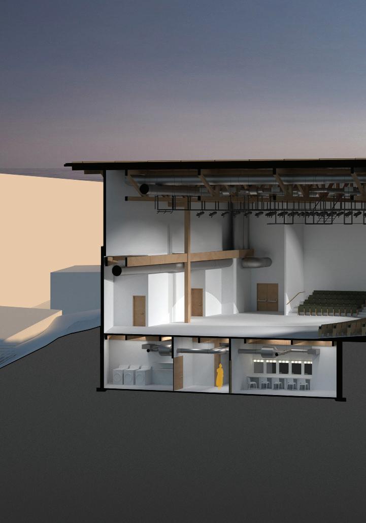
Carousel Theatre
The Ula Love Doughty Carousel Theatre is a hub of connectivity within the University of Tennessee’s campus. The initial theatre was built in the 1950s and has been a work in progress ever since. Every development was a functional renovation that worked to connect it to time and community. This proposal balances the needs of the community as well as the performers to offer an experience that does not set limitations on theatre magic.
The proposed redesign focuses on the ideas of reinvention, connection, and efficiency through a series of different perspectives to negotiate the threat of obsolescence set by the existing theatre. Seating just under 400 people, the Carousel theatre will now be able to function in both a theatre in the round set up as well as a thrust position to reinvent the typical theatre experience. The heavy timber construction draws a connection to the historical relevance of the original Carousel theater. Lastly, the project addresses LEED requirements, a prescribed list of necessary spaces, and conditions set by the university to manifest a contemporary experience.


Death as an Interval
Spring 2021 | Marleen Davis Siciliy has a deep history in handling death and loss. The small island has a series of overlapping burial traditions that support the Sicilian Mafia, war memorials, and the Catholic Church. While each community’s way of handling death is different they overlap in that death entails a sense of display.
Just outside the town of Tripani is an abandoned WWII cemetery in which this proposal is located. The existing cemetery was outlined, but never fully completed. This proposal looks to utilize this land to establish a new cemetery where each community can overlap and display their traditions.
The project offers a funeral home and crematorium that connects to the reflecting pools, chapels, and burial plots. The other half of the site is a community center with a cafe, flower shop and park with bocce ball. This collection of programs makes the cemetery a place for community engagement and strengthens the existing connections they culturally have with death.
All the darkness in the world cannot extinguish the light of a single candle.
Death as an Interval a center for death and the commuunity


Fall 2019 | Kevin Stevens
Knoxville Food Hub
1400 Washington Avenue in Knoxville is a site that offers an intersection between neighborhood, park, and retail. This allowed it to be a central location for a community of farmers to bring their produce for processing. Under the “Canoy of Connected Space”, a series of redesigned butler buildings exist to serve the local community. The buildings include Dispense and Distribute, Edible Education, Open Locale, Commercial Kitchen, and Filigree.
In contradiction to the Knoxville Regional Food Hub Survey, this project offers another look at the potential of the distribution of local food. The proposal uses the traditional butler building in a reimagined way to make the statement that efficiency should not limit human interaction and community benefit. The butler building model can be reproduced and constructed quickly for multiple purposes. In the same way, typical food distribution is based on fast reproduction and efficiency. The research shows that there is an extensive variety of producers in the area that have a hard time selling their food because they are unaware of certain standards that need to be met. This proposal allows for those shortcomings to be met and opens additional opportunities to a now connected group of local users.


WIDE FLANGE BUTLER BUILDING + CONNECT


SUBTRACTION + IRREGULAR SPACING

SUBTRACTION + SPACE DEFINITION

INVERTED BUTLER BUILDING
CONNECTION + ADDITION
SUBTRACTIONREFINE + FILIGREE


The Mississippi River Basin reaches 1.245 million square miles, 31 states, and 2 Canadian provinces. It establishes itself at the headwater in Lake Itasca, Minnesota. From here, a single drop of water begins a 90-day journey to the Gulf of Mexico.
Along the way, that drop of water crosses fields of rich commodities, Army Corps levees, and music centric hubs. Through sound and sketch, this project looks at five cities along the Mississippi, working towards an understanding of the site beyond geographic context.
Historically, the river is known for shifting courses over time, as it has a natural cycle of building and releasing itself into the floodplain. The government began its attempt to control the river in 1820 when it asked Congress to “keep the river in its path and out of politics.” As evident by the 1927 flood, this static highway of water did not work. The rigidity of the Army Corps approach is counteracted by a culture of music and storytelling. This project lies at the intersection of both. These five moments along the river don’t tell the full story, but they begin to speak about our understanding of the Mississippi as an economic, natural, and cultural force.


A series of sketches were produced by listening to a curated sound of news clips, songs, and sounds. This was once individually per city and then once together. These sketches were then combined to produce 3D rollers inside the printers.


Memphis, TN
New Orleans, LA
Each city represented a different personality of the river and was documented through a map, photos, musical production, flooding events, and sound sketches.


“The changed life of these river towns is nonetheless good, though somehow tomorrow’s romance has not yet made fiction of the earthy reality of today.”


“Yet the war that it has declared on the Mississippi is far from won or, for that matter, lost. It has merely become an everyday practice, embodying conflict in a unique landscape of levees, cutoffs, revetments, overflow channels, floodways, locks, gates, and jetties.”


The printer is comprised of a series of patterned rollers that depict a combination of sketches produced in response to the audio. The process of these sketches are documented in stills. At which point they were combined and digitally fabricated. The drawing that these rollers produce is an analytical representation that tries to embody our expression of the sound.


Anachronistic Landscapes
The studio used iterative processes to break down and reorganize completed landscapes in order to establish a new anachronistic landscape. Within that framework, I worked through iterations of Fursewald Cemetery, South Park, Double Negative, and Amsterdamse Bos. This landscape is a response to the instability that traditional burial practices impose on the landscape and uses an iteration of Furstenwald Cemetery to dictate possible communal burial plots. This type of burial historically disconnects loved ones and causes environmental problems with soil stabilization. In order to establish fertile conditions the proposed plots would use two burial practices. The first would be a shallow grave burial to allow for a cadave to have oxygen and naturally occurring nutrients can be reached by vegetation. The second is the use of a project called Infinity Burial Project which anticipates burrial in a ‘mushroom suit’ that is laced with spores chosen to accelerate decomposition and remediate pollutants ingested in our lifetime.
Formally this landscape is a series of low poly mounds capped by vegetation at varying ages. The experience of the cemetery is a pilgrimage to find your loved one and find a connection to the space. A final consideration I made was in terms of grieving. The Cherry Blossom tree is implemented as a representation of rebirth, reincarnation, and hope. Pulled from Amserdamse Bos. These are planted and retained by a series of benches pulled from the South Park pavement study. This new type of cemetery allows the living to grieve the process of death and rationalizes the inevitable with consideration of environmental health.


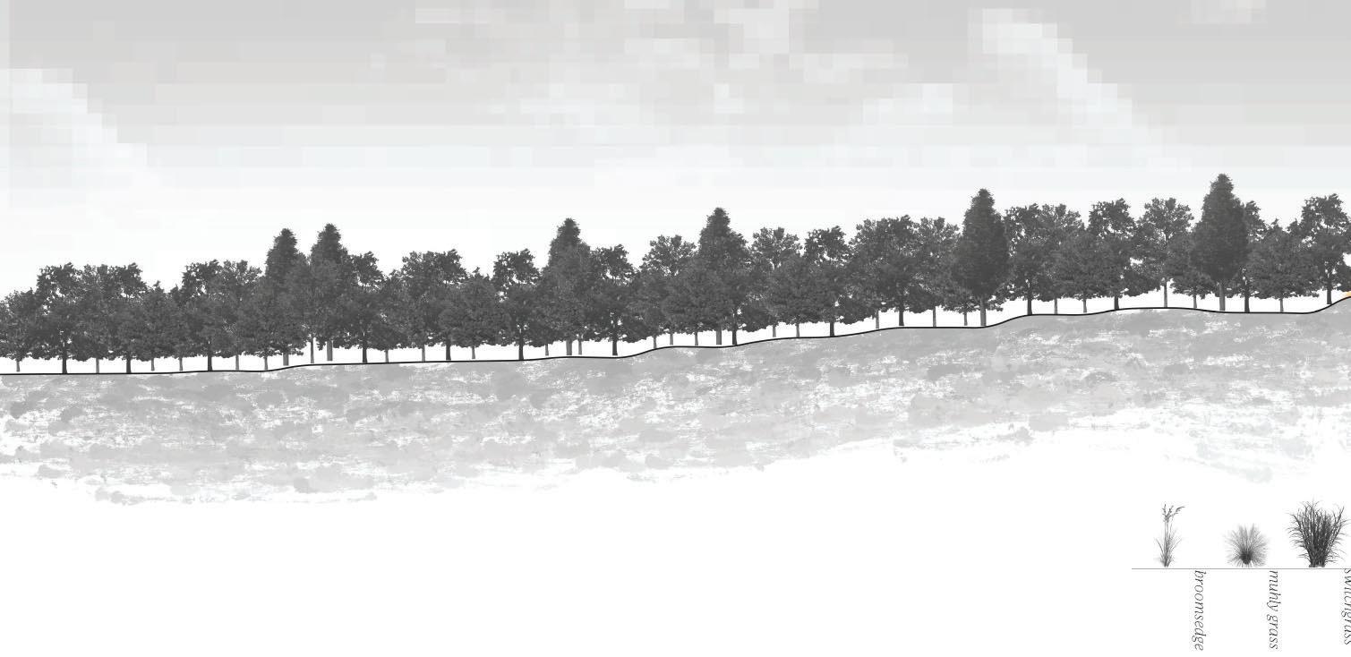
Urban Corridor
To preface, this work looks at the urban context as our new natural and works to break down the narrative that our natural world has been untouched. It is no longer how we can design for ourselves, but how we can design with the consideration of flora and fauna on an urban scale. With that being said, the development of our urban context has resulted in habitat fragmentation and a reduction of biodiversity. Through development, urban spaces have been contaminated, redeveloped, and abandoned. This scheme describes a pixelated planting pattern connecting the residual underused spaces. I am working to establish a reimagined urban corridor where the native flora and fauna are the clients, but urban development is the foundation.
There are three primary scales within the context. The range of scales begins at the stratigraphic ridges of East Tennessee, to Knox County city parks, down to the entrance of the corridor. The success of an urban corridor lies in its ability to connect multiple elements to reestablish a quasi natural pattern of migration and territory distribution. These boundaries can bridge scales and break down connecting elements. The boundaries established in my proposal are defined by the ability to connect abandoned lots, backyards, and city parks.

The planting pattern is a negotiation between man made built form and territory requirements to specific fauna. The fauna was picked due to its likelihood to be recognized by humans and its ability to establish a food chain throughout the corridor. I work with a series of rules that dictated where grasslands, shrublands, and forests would be planted. The rules were as follows; if it intersects with a road then it is a grassland, if it falls in the territory range of a bunny is edged by a forest, if it crosses water then it is a shrubland, if it abuts a neighborhood then it is a shrubland, if it crosses a city park then it is forest, single and incomplete squares are forest and space between turtle and rabbit territory is shrubland. The ‘it’ refers to the one acre grid that arbitrarily fills the corridor boundary.
rule set_5


_if it intersects with a road then it is a grassland
_a territory range of a bunny is edged by a forest
_if it crosses water then it is a shrubland
_if it abuts a neighborhood then it is a shrubland
_if it crosses a city park then it is forest
_single and incomplete squares are forest
_space between turtle and rabbit territory is shrubland
rule set_1
_it if touches a neighborhood then it is a grassland
_if it crosses water then it is a shrubland
_if remaining clumps of 1-3 then it is a forest
_if it crosses a city park then it is forest
_connect same vertically unless one block in between


_alternate grassland and shrubland from south to east
rule set_2
_if it intersects with a road then it is grassland
_if it abuts a neighborhood then it is a shrubland
_if it crosses water then it is a forest
_forests divide turtle habitat

_space between turtle and rabbit territory is shrubland
_incomplete squares are forest
_single squares are grassland
_remaing groups are forest
rule set_3
_a territory range of a bunny is edged by a forest
_if turtle territory intersects with water then it is shrubland
_if it is clumps of 1-5 then it is grassland for bees
_line remaining edges with shrubland for fox

_based off single holes, fill with alternating densities

rule set_4
_if it intersects with a road then it is a grassland
_a territory range of a bunny is edged by a forest
_if it crosses water then it is a shrubland
_if it abuts a neighborhood then it is a shrubland
_if it crosses a city park then it is forest
_single and incomplete squares are forest
_space between turtle and rabbit territory is shrubland

_alternate in two row str ips between forest and shrubland from south to east


Fall 2017 to Fall 2022
Representation
Built into the University of Tennessee’s curriculum is a series of representation courses that allow students to explore fabrication tools as well as to explore a multitude of programs. These quick projects offer a playful exploration into representation and spatial thinking.

ONE TO ONE
This project was an exercise in working with digital fabrication tools to design a piece of furniture that is to scale. Functionally, the chair works as a desk chair as well as a recliner once unfolded. A series of iterations were made by laser cutting different materials to test a number of theories. The final design was cut out of a single sheet of plywood and milled on a CNC. The chair is assembled with no metal so all joints are wooden dowels hammered through holes drilled into the edges.


MODEL MANIA
This investigation into modeling proposed nine models in nine days. The sprint encouraged efficient iterations with clear intentions. I was working through different landform strategies and their representations. This included paper, wax, a combination of paper and wax, clay, laser cut concours, CNC milling and 3D printing.


PLANTING CHALLENGES
Planting challenges have been a way to work through specificities of sites. These two are a continuation of one another that looks at both the ground plane and green roof of a site in Boston. The projects work through understanding Hardiness zones, site specificities, and planting seasonality.

STRANGE SITES
Strange sites was a way to reframe the understanding of a site and its elements. In this exercise, I chose a site to photograph at varying scales. I then pulled out elements using photoshop that told a story about the site. These elements were then composed in order to offer a new reading of the space.

