
Cassandra Salehi Hammerstad Master of Architecture ’15-’21

INDEX2
3 p. p.42p.40p.38p.p.26p.20p.140432Shiraz, Iran Spring 2021 Herlev, Denmark Fall Djursland,2020 Denmark Spring 2020 Valby, Denmark Fall Roosevelt2019 Island, USA Spring Copenhagen,2018 Denmark Spring 2018 Rabat, Morocco Fall 2015-20222016 PRESERVING PAIRIDEZA HERLEV MOBILITY HUB WHERE WATER SETTLES THERE’S ALWAYS A LAWN MOWER IN SUBURBIA WATERFRONT PHOTOGRAPHYTEACHRISTISTIANSHANDPULSETOWER0007060504030201
4 Shiraz_Paradise universitysemestertutorsiteRoyal Danish Academy MA. Spring 2021 Tamara KalantajevskaShiraz,Iran diploma project
A preservation strategy of the Per sian garden as critical infrastructure and for cultural production.
I have called attention to the numerous Persian gardens that have been demol ished, due to mass migration and the need for rapid residential development. With a harsh climate and a society torn apart, I have explored the garden’s potential to be the mechanism to unite the two sides. Un locking the economic and social potential of cultural conservation, reveals how heri tage is a shared narrative and not only ma terial remains. By using the notion of para dise as a vision shared by all Iranians, this project find symmetry between the story of the past and the necessity of the present.
PRESERVING01 PAIRIDAĒZA
5 Shiraz_Paradise
| https://issuu.com/cassahammerstad/docs/nooneknowsaboutpersianplanning

| https://issuu.com/cassahammerstad/docs/preservingpairidaezaprogram Also
See
Research Essay Diploma Program
“Over the course of time, many historical gardens have been deliberately destroyed, while others are badly conserved or in a state of dereliction and suffering continued decline. The historical garden is not celebrat ed as an important part of the heritage, and the issue of garden conservation is widely neglected... This lack of attention could be the result of the intense political changes the country has faced, ... and a lack of clear vision about what is important within these gardens.”
‘Historical Gardens in Transition in 20th Century Iran: A Critical Analysis of Garden Concervation’ Sara Mahdizadeh June 2014


Iran faces two pressing environmental is sues; high pollution and low precipitation. For my strategy I looked to turn these trends by expanding access points to the ancient qanat system. This will regenerate existing gardens, together with the possi bility for new gardens to appear.


6 Shiraz_Paradise 01 the symbolism
Throughout history, the walled gardens have been planned in response to a harsh climate and out of physical necessity, as a contain microcosm. Gradually they devel oped into spiritual and aesthetic entities, where the garden was to be the closest possible version of paradise on earth. These ideas were represented in the gar den through the use of water; as a cool ing element and as a way to reflect the heavenly. For this reason, water became an overarching element across the three scales of the project; The city strategy, the garden plan, and the wall element.
Model Photos
7 A B C D E F G H I J K L M N O P Q R S T U V W X Y Z Æ Ø Å Ö2928272625242322212019181716151413121110987654321 353433323130 Shiraz_Paradise 01 the strategy Shiraz Strategy Plan green cityhistoricalgreendemolishedriversspringsstreamscanalswellsqanatsexistingnewexpandedexpansionnetworkwellsnetworkgardensareascenteroutline


8 Shiraz_Paradise 01 the garden
AgricultureSanctuaryproduction pleasure modern tradition


Women Historical Creative
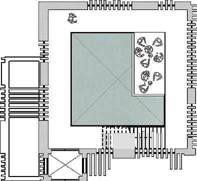
In the next phase, I located a dilapidated garden to further explore the ideas of preser vation. I challenged the status quo and revived it into an inclusive public garden. The two main traits of historical paradise registered were the wall and the central axis. The traditional rivers of water, milk, wine, and honey, were redefined as production - pleasure and tradition - modern, defining 5 zones within the garden, where the old and the new live in Thesymbiosis.women’s
section, enclosed by a lighter structure, plays with visibility and boundaries, where women can let their hair loose. The creative quadrant features Persian dance and music, inspired by Shiraz Festival of Arts which was discontinued after the revolution. The Agriculture square gives a profit to the garden, where visitors can pick, pay, and wander in an observatory of fruits, herbs, and flowers. The historical garden highlights the spiritual life of paradise and welcomes visitors to smell, feel, and gaze at the garden’s vegetation. The Sanctuary welcomes visitors into the life within the wall.

9 Shiraz_Paradise 01 the garden Handdrawn Perspective Plan A A DD B B C C E E

10 01 the wall Shiraz_Paradise street vendor producation platform producatin pathway canopey walnut elm ash ash birch street almond pistachio Agriculture Section D-D


11 01 the wall Shiraz_Paradise pathway herbs recreational pathway under lofty trees tea producation pathwayplumb trees apricot trees cypress tree of heaven oak entrance magnolia cypress

12 textured trees seating stairs stage seating steps hallway labirynth

Shiraz_Paradise 01 the wall
Iran is a country built up on walls and the English word ‘paradise’ originates from the Persian word ‘pairidaeza,’ comprised of ‘pairi’ (around) and ‘daeza’(wall). To emphasize the word’s meaning I intro duce a solid wall with carved-out spaces. The size and function of the rooms change throughout the wall, connecting the out side with the inside. This is where the visitor experiences the visual and physical entering into the garden. Then a layer of water, that mirrors the wall, and functions as a ritual of entering. Here visitors can get their feet wet and cool down, evoking all senses, before entering paradise.

“Autumn winds can never avail against (this garden) nor will passage of time turn its splendour and joyousness into grief. Till time and Persian literature continue “this garden will bloom and thrive!” Saadi, 13th century

13 Shiraz_Paradise 01 the wall Casted Wall Models


Royal Danish Academy MA. Fall 2020 Christine Bjerke Herlev, ChristianDenmarkSchmidt
A pragmatic approach to mobili ty that considers the current technological and societal conditions. Due to continuously rising car ownership and urban sprawl more than 200.000 cars commute to and from Copenhagen every day. Congesting our cities as a re sult. Whereas public transport is limited to the main corridors, 80% of Copenhagen’s streetscape is infrastructure for cars, giv ing it the upper hand. This suggests the need for the private and the collective to work in symbiosis, in order to trigger a car-free city. We propose mobility and community hubs as a transition spot that connects and strengthens the collec tive transport as well as communities.
HERLEV02MOBILITY HUB
14 Herlev_Mobility
universitysemestertutorsitegroup
15 Herlev_Mobility
“As our cities continue to absorb the growing population, it is becoming increasingly clear that we must abolish cars in favor of smaller and more public transport modes. Cars simply take up too much space, and our cities cannot continue to devote as much space as they did in the 20th century, if we are to meet the challenges of the 21st century.”
‘Gentænk Flertallets Daglige Mobilitet,’ ARKITEKTEN Robert OctoberMartin19th, 2020

2015198219451911builtferrytrainhighwaycopenhagenhubsarea-1,75km-3,5km-12,1km-21,7km
Herlev
Introducing a line of mobility hubs in the outskirts of the city will help facilitate the transition from private to public transporta tion. We identified seven locations for the mobility and community hubs and select ed Herlev as the focus. By 2035 Herlev is expecting a 439% increase when it comes to the number of shifts between collective transportation. This is due to the planned light rail, to be completed by 2025.
Today there is an inherent inefficiency of space connected to the use of the car.

02 the strategy Site Plan Area Plan bus cartraintramstationstationstationparking mobility

Herlev_Mobilitymainroadtraintrackstramlinebikelanestationexistingconnectionsnewconnectionsnewramplandscape
Framing the site today are three main roads and the S-train. By consolidating bus, train, and light rail stops into one co herent mobility hub, optimal convenience will offer an incentive to transition across private and collective modes. With this, we see the potential in transforming Big shopping center into Herlev Mobility and Community hub.
16
17 Herlev_Mobility 02 the site Model Photos


The transformation will happen in four stages. First reexamining, stripping the building down to its resilient concrete structure. Then we restruct, with a focus on the flow to make the navigation be tween mobility modes and programs clear and convenient. The central spiral is for pedestrians and cyclists, while the ramps along the facade are reserved for cars. New and existing programs are then reor ganized, with commercial and recreational activities alongside parking and stations. Finally, we redefine the hub with a new light facade that communicates connect edness. Grounding the hub is the land scape that floats into the open ground and influences the commercial programs with its rounded corners for effective flow. By celebrating these everyday situations, the coexistence of programs creates a di alogue between the public and the private. This establishes the hub as both a trans portation node and an urban setting.
redefiningIV lightA. rail station groceryparking store library fitness
18 Herlev_Mobility 02 the transformation Exploded Axonometric A B C D


greenpublictrainD.rooftopstreetsharedbusC.handyparkingB.storestationmobilitymekkastationplazalandscape
reorganizingIIIrestructuringIIreexaminingI
19 Herlev_Mobility 02 the prospect Model Photos


Royal Danish Academy MA. Spring 2020 Tamara Kalantajevska Kolindsund, Djursland, Denmark Julie Marie Madsen
20 Djursland_Water
Denmark’s lake area has more than halved to satisfy agricultural hunger for land. Yet, without considering the inevita ble, the outcome has not proven success ful. Our aim for this project is to redistrib ute land shares for a future with room for water; A redistribution for diversification. The state needs to assume a greater role in securing a more holistic climate plan, as sea level rise has proven to be an urgent problem in Denmark. With this in mind, we consider the paradigm shift taking place. Instead of the adage fighting against the water, we hope to work with nature.
A logistical strategy of land re versal and redistribution in a future scenario of rising sea level.
universitysemestertutorsitegroup
03WHEREWATER SETTLES
“Over the past 200 years, Denmark’s lake area has more than halved to satisfy agriculture’s hunger for more land, and it was especially the large shallow lakes that had to hold, for example, Jutland lost its two largest lakes, Kolindsund and Filsø. Time and again, however, it turned out that these magnificent projects were based on inaccurate assumptions and poor engineering design...”

‘Lokalt kom ingen til at »skumme fløde« på Kolindsund,’ Det Tabte Land Kjeld Hansen
21 Djursland_Water
03 the strategy Strategy Plan East Jutland

22 60m contour 30m RANDERSVIBORGconstructedagriculturalrepurposedurbanforestwaterprecipitationcontourareaslanddikes DJURSLAND HADERSLEVKOLDINGFREDERICAVEJLEHORSENSAARHUSSILKEBORGDjursland_Water
In 2016 the Danish government launched the ‘land allocation plan,’ aimed to encourage wet lands with new nature. We identified 8 additional areas with opportunity for new forms of culti vation and recreation. What if water can be the opportunity for a shift in Denmark’s monocul tural land share? Kolindsund in Djursland, once a shallow lake, is today farmland kept dry by two pumping stations. Restoring the lake will catch new employment, tourism, and biodiversity.
In 2050, when the sea level has risen about 1m, the lake will reappear past its original bound ary. Constructing dikes will help secure residential areas, while also posing as a green buffer complemented with a pathway. The selected trees will withstand flooding and stabilize the ground. This natural transition connects transformed and new structures. Now the edge is activated for tourism and the water has become a production line.

23 Plan 1:25.000 GRENAA KOLIND new forrestmunicipalpumpingboundarystationborder agriculture fields waterriversroadsexistingpumpinggreenpathwayshedsaquawaterriversroadstrainfarmingbufferstationstructures0m,-3m Plan 1:5.000 Proposed Axonometry Djursland_Water 03 the site aqua pathwayfarmingnegotiation house (old pumpingshedsstation) aqua frams


03 the typology

Djursland_Water
Reorganizing and expanding tradi tional farms to be suitable for aqua farming, will give newopportunities.sustainableBuilding
Transforming the pumping station into a negotiation house will help establish conversations and communities around water’s right to settle.

24
Negotation house Aqua farmsCommunity sheds
small colonies of sheds along the pathway, housing different activities such as kitchens, sauna, and storage, will welcome visitors from far and near.

25 Djursland_Water 03 the prospect Visualizations


universitysemestertutorsitegroup
Suburbia as we know it is at risk; Will the rit ual of the lawnmower survive the expand ing city? As Valby is getting densified and evolving into a fabric consisting of urban blocks with new city life, the essence of suburbia is at a vulnerable position. As we question how these two inverse, yet par allel, situations will affect each other, we have designed a strategy plan for just how the two antipoles can coexist. The project is experimenting with ways of indulging suburbia with the new developments of the city, realizing that suburbia will inevitably be affected by the urbanization of Valby. ALWAYS A LAWN IN SUBURBIA
MOWER

Royal Danish Academy MA. Fall 2019 Carlos Ramos Valby, Copenhagen, Denmark Sara Emilsson
A strategic plan to rethink what suburbia will look like during an economic and a housing crisis.
26 Valby_Suburbia
04
THERE’S
27 Valby_Suburbia

“City dwellers and suburbanites need each other to reinforce their own sense of place and identity despite ample evidence that what we once thought were different places and lifestyles are increas ingly intertwined and much less distinct.”
Worlds Away: New Suburban Landscapes Andrew OctorberBlauvelt7th,2014
TodaysSituationExcessAreaPathwayBufferZoneNewDwellings
As the differences are not as distinct as we once thought, the homeowners can be the answer to the current economic crisis, by inviting the newcomers into suburbia.
Central in the new development is the pathway that runs between the suburban hedges, opening up to a constellation of spaces in the form of intimate squares and parks. They create the nerve center of the area from where access to new dwellings is provided. This new suburbia will enable the existing detached houses to raise themselves over a new carpet of single-floor houses.
04 the strategy

28
Valby_Suburbia
If entering a CLT, Community Land Trust, homeowners can redevelop parts of their land for new housing, a model that would benefit the homeowners, while also cre ating a solution to the housing crisis hap pening in Copenhagen.


29 Valby_Suburbia Masterplan 04 the masterplan

30 Valby_Suburbia 04 the typology Public PrivateBackgardenHousegardenFrontStreet&Pavement Private PrivateSemi-Private Semi-PrivatePublic PathwayDwellingDwelling CourtyardStreet&Pavement Type example suburban home Type example proposed dwellings


31 Valby_Suburbia 04 the prospect

Working with a spectrum from public to private, we are searching for a balance between the homeowners and the new comers in this constantly evolving city. Finding a way for the old and the new to live together in an updated suburban, somewhat urban, space. Together they enhance the essence of suburbia.
As two opposite demographics, the new structures will be placed as an inversion of today’s suburban houses, ensuring privacy. The fresh structures frame the existing front and back garden, while also enclosing a shared courtyard for the new city dwellers and their lawnmowers.

A schematic design aimed to prolong the waterfront interest through access and viewpoints. In New York, we see how the water has become a barrier between the perfect and the imperfect. Islands, like Roosevelt, have become places to send the unwant ed. Yet, today the Island is experiencing new housing constructions, as with a quick gondola, metro, ferry, or car ride you arrive. Considering new communities ap pearing and the sea level rising, we have looked into connecting the whole island and its access points, along the waterfront. Allowing the glimpse of views across the island and the waters to lead the design and highlight what Roosevelt has to offer.
32 Roosevelt Island_Waterfront
WATERFRONT05 PULSE
Politecnico di Milano BA. Spring 2018 Contin Antonella & Gaia Caramellino Roosevelt Island, NY, USA Malte Ottosson, Malgorzata Mynte & Austeja Mielkute
universitysemestertutorsitegroup
“Roosevelt Island, Randall’s Island, Ward’s Island, Rikers Island, and Hart Island have all been places where the tired, poor, sick and criminal are sent to be treated—or sometimes just confined—far from glitter ing Manhattan. The water has served as a kind of moat, as well as insurance against NIMBY protestations. These islands aren’t part of anyone’s backyard, which has made them a perfect place for the unwanted, nestled in plain sight of one of the world’s great cities.”
33 Roosevelt Island_Waterfront
‘Islands of The Undesirables: Roosevelt Island,’ Atlas Obscura Bess Lovejoy June 1st, 2015

Pulsation was the concept for this project. Creating a pushing and pulling effect from Manhattan waterfront through Roosevelt Island, and to Queens Waterfront. We decided to improve and secure the waterfront along the residential and arrival points of the island. These are all located in the center of Roosevelt, which is more compact than the rest of the Island. There fore, we created new piers and a pathway along the waterfront in order to enlongate the public spaces. Each pier is an exten sion of an existing street or an area that leads to the main street on the island. Thus each pier is specifically designed for the needs and the activities of the certain area; school, kindergarten, church, apart ment complex, ferry harbor, and parking. Highest Waterfront-4mLowest Waterfront-5m
34 Process Diagram Views Connections WaterfrontNew BoundariesExisting Area Interventionof AreasConnected

05 the strategy Roosevelt Island_Waterfront

35 1 Indoor Gym 2 Car Parking 3 Outdoor Gym 4 Metro Passage 5 Retail Restaurantand Zone 6 Farmers Market 7 Service Space 8 Ferry Terminal 9 Bike Rental 9 78 6 4 5 4 2 3 1 2 A A BB RooseveltPlanIsland_Waterfront 05 the site

36 Section SectionPointA-ACB-BRoosevelt Island_Waterfront 05 the typology


To create distinct waterfronts and piers based on each area, we sketched sections. This helped us outline how the residents would meet the waterfront. Once again, we used the idea of pulsation to differentiate between inside-outside, public-private, and up-down. We introduced three levels, where the lowest level, depending on the water, might be flood ed. This will shield the Island against rising sea levels, while also giving Roosevelt Island two different waterfronts. All in the hope to create more dynamic public spaces on Roosevelt Island and connect it back to its neighboring islands.

A BB C Roosevelt Island_Waterfront Masterplan 05 the masterplan

37
RooseveltManhattanQueensIslandA
Politecnico di Milano BA. Spring 2018 Raffaella Colombo Copenhagen, Denmark Malte Ottosson, Alexandre Wellers & Alexandre Tchoubanov
CHRISTIANSHAND06universitysemestertutorsitegroup
38 Christiandhavn_Hand
A playful project aimed to under stand the needs of the site and its inhabitants; a helping hand. We identified five problems at Christian shavn; few bike racks, lack of space for street dwellers, an inactive area, poor connections to public transportation, and the waterfront. Thereafter we identified five zones, each dedicated to solving one of the problems: 1, expanded vertical bike parking, with easy access to bike paths. 2, housing tower with common kitchens, bathrooms, and shared bedrooms. 3, a marketplace for food trucks and seat ing within a green lung. 4, expanded connection point to the metro. 5, a rec reational connection to the waterfront.

39 SectionChristianshavn_HandPlanA-AAA 1 2 3 4 5


TEA07TOWERuniversitysemestertutorsitegroup
40 Rabat_TeaTower
A disruptive and delicate at tempt to view traditional design and environment in a new way. Located on one of the two strips of land that runs out on the water, this tea cafe provokes the horizon line at Plage de Rabat. Viewed from above, the circular placements of the seating, which is based on the Persian eating style, create the feel of a traditional Moroccan riad, with a square opening in the center. For the facade, I focused on light and shadow, with three modules of different widths and lengths. The openings between the modules allow visitors a view out over the water and the city, as well as light, air, and smell of the ocean into the building.
Royal Danish Academy BA. Fall 2016 Helle Deng Rabat, Morocco

41 Rabat_Tower 4th floor 8th 2nd3rd4th-7thRooftopSeatingBathroomsReception& kitchen 1st Office, changing room for workers & storage 5th floor 6th floor 7th floor 8th floor3rd floor 2nd floor 1st floor Landscape Section


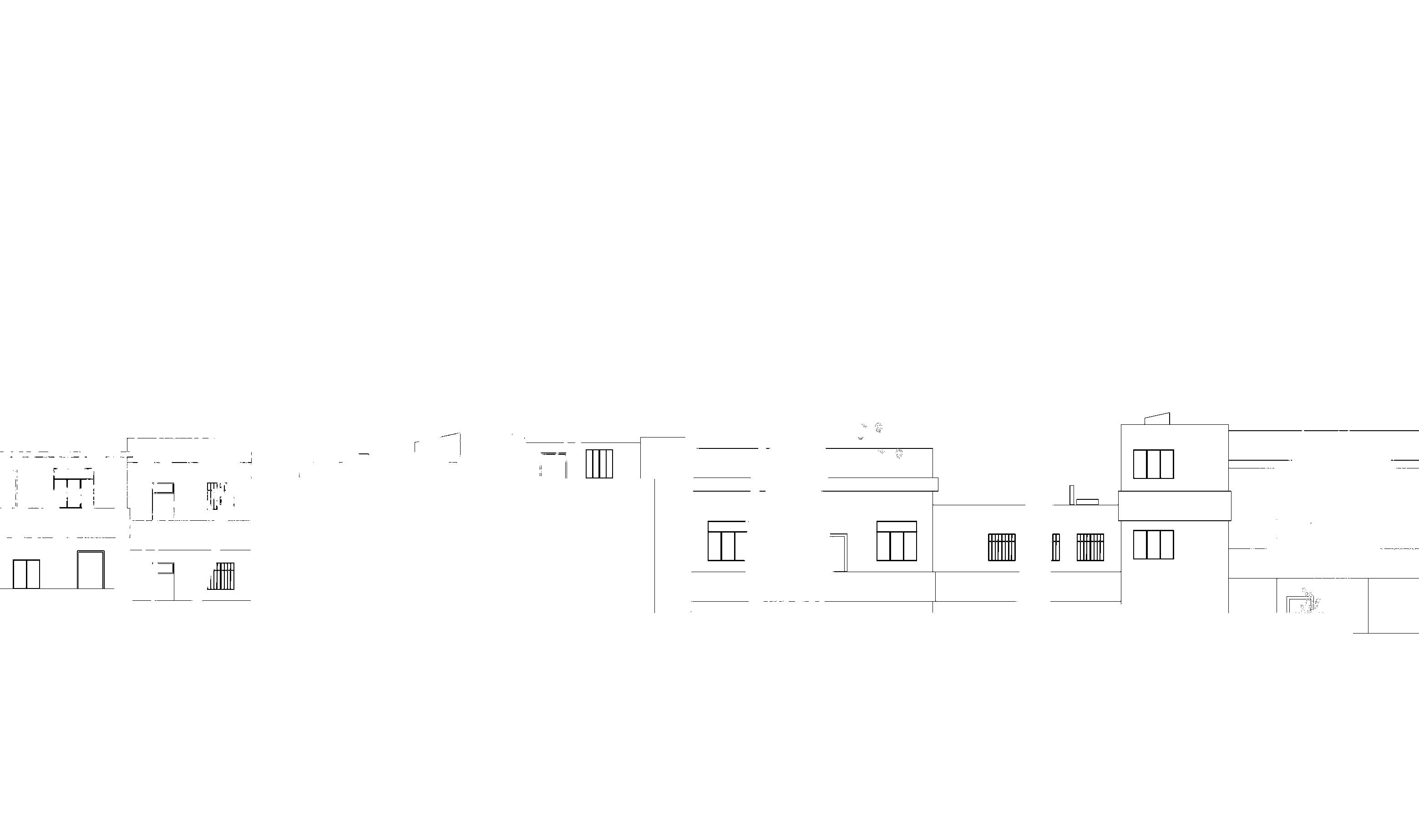
42 00 photography


43 00 photography


BIBLIOGRAPHY44
45 IN THE ORDER THEY APPEAR Mahdizadeh, Sara. “Historical Gardens in Transition in 20th Century Iran: A Critical Analysis of Garden Conser vation.” The University of Sheffield, Jun. 2014, p. 1, etheses.whiterose.ac.uk/6634/1/pdf%20final%20Aug%20https:// Martin,2014%20nn.pdf.Robert.
“Gentænk Flertallets Daglige Mobilitet.” Arkitektforeningen, 19 Oct. 2020, https://arkitektforenin
PåHansen,gen.dk/arkitekten/gentaenk-flertallets-daglige-mobilitet/.Kjeld.“LokaltKomIngenTilat»SkummeFløde«Kolindsund.”DetTabteLand,https://www.dettabteland. Blauvelt,dk/midtjylland/kolindsund.pdf.Andrew.WorldsAway:
New Suburban Landscapes, Walker Art Center, Minneapolis, 2008, evelt-island-blackwell-s-island.lasobscura.com/articles/islands-of-the-undesirables-roosIsland.”Lovejoy,landscapes/#.ryboard.cmoa.org/2014/10/worlds-away-new-suburbans-https://stoBess.“IslandsoftheUndesirables:RooseveltAtlasObscura,8June2015,https://www.at-
takk | thank you | merci
