
12 minute read
Objective C: Prioritising investment to the most at risk communities


214. Mapping and messaging has already been improved following a recommendation from the Wales Coastal Flooding
Review53 and the Public Accounts Committee54 to develop consistent advice and online information to the public before, during and after a flood. The publication of FRAW in the
Wales Flood Map will further underline our commitment to continuous improvement in communicating risk. 215. The Welsh Government has asked NRW to continue working with Local Authorities on improving digital information provision to the public. Recent research has indicated that the public require clear, concise and consistent information which can be easily accessed via smart phones as well as more traditional methods of communication. Building on this research, NRW will continue to develop their online flood pages to become the central hub of information for flood and coastal risk in Wales. 216. The measure below meets the recommendation from the
National Assembly’s Public Accounts Committee; however we recognise this work is continuously improving as we benefit from new information and changes in the way it is accessed.
We want to improve awareness and access to information on flood and coastal risk management.
MEASURE 12: NRW to complete their online flood information improvements, working with WLGA and Local Authorities, by 2021. This will include publication of the Wales Flood Map products, understanding flood warnings and advice on building resilience and responding to flooding.
Objectives supported: A, B, D and E
Objective C: Prioritising investment to the most at risk communities
217. As communities have developed so has a significant network of flood risk management assets, coastal protection and drainage infrastructure to help reduce the risks faced.
Although these arrangements have generally worked well in the past, and are still working in most parts of Wales, the effects of climate change mean that the pressure on our existing infrastructure will increase significantly. 218. It is not possible, nor is it sustainable, to protect all areas from flooding or coastal erosion. Flood alleviation schemes reduce, but do not completely remove the risk of flooding. No matter how big the defence, t-here is always a possibility it can be breached or over-topped, leading to ever-more catastrophic consequences. Therefore, there will always be a residual risk that drainage and defences alone cannot address and a reason why raising awareness with the public is important. Reducing risk at Crindau, Newport

Crindau, Newport has a long history of tidal flooding. Existing defences were in very poor condition, offering a low level of protection up to a 1 in 10 year flood event. NRW’s Crindau Flood Risk Management Scheme will reduce flood risk to 667 properties, providing protection against a 1 in 200-year event. The scheme has been designed to be adaptive to climate change beyond 2064. Phase 1 included constructing flood walls behind the industrial properties and a new embankment through Shaftesbury Park. Several seated terraces have been built overlooking the playing field to enhance this local amenity and a new footpath and cycleway now run through the entire park.
219. Interventions to reduce flood risk are prioritised according to risk using the Communities at Risk Register and evidence of flood events, alongside supporting information on properties and wider benefits. 220.The Welsh Government prioritises FCERM schemes which primarily reduce risk to homes. Businesses and public buildings can also benefit from flood alleviation schemes, in particular those schemes which reduce risk to a mix of development types such as homes and shops along a high street or local district centre. Schemes which only reduce risk to businesses remain eligible but should not be prioritised over schemes which reduce risk to homes. 221. Planning policy directs highly vulnerable development, such as homes, away from high and medium flood risk areas. Less vulnerable developments may be permitted in the flood plain where the risk is considered acceptable for that development use and can be appropriately managed.
FCERM schemes should not be required to defend these developments. 222.Traditionally, flood and coastal risk interventions have been focused on engineering measures such as walls, groynes, embankments, and drainage improvements. However, in some instances these interventions have led to adverse impacts or increased risks elsewhere; RMAs should use appropriate modelling to establish any negative impacts associated with such measures. 223.In line with the Flood and Water Management Act 2010, reducing the risk of flood and coastal erosion can include working with natural processes or Natural Flood
Management (NFM). This approach is in line with our
Natural Resources Policy, and is encouraged in all FCERM interventions, either as a stand-alone or hybrid scheme.
This approach also supports the First Minister’s vision for
Wales to become a World leader in green technology and sustainability. 224.During the option appraisal undertaken as part of scheme development, we encourage RMAs to consider a broad spectrum of measures options,
Figure 13: Option appraisal continuum
No intervention Management Option
Natural Flood Management
225.The continuum shows options for intervention including managing the behaviours which cause the problem, through NFM, to ‘grey’ or ‘hard’ interventions. Whilst traditionally flood risk management has involved hard engineering interventions to the right of this spectrum, we want to see more measures which work with natural processes to reduce flood risk.
Figure 14 – Catchment Diagram, Working with Natural Processes, Adapted from the Environment Agency (2017)
Natural Flood Management 226.A key priority of this Strategy is to deliver more natural interventions and catchment approaches to help improve environmental, social and economic resilience. This includes working with natural processes and green infrastructure on the above spectrum, and collectively defined as Natural Flood Management (NFM). Mitigating flood risk through NFM also aligns with the Natural
Resources Policy and our move towards a low carbon based economy, outlined in the Economic Action Plan55 . 227. NFM has been described as “reducing flood and coastal erosion risk by implementing measures that help to protect, restore and emulate the natural functions of catchments, floodplains, rivers and the coast”56. Examples of NFM include interventions such as tree planting, offline storage areas, in-stream obstructions, soil and land management, dune and beach management and creation of new wetlands.
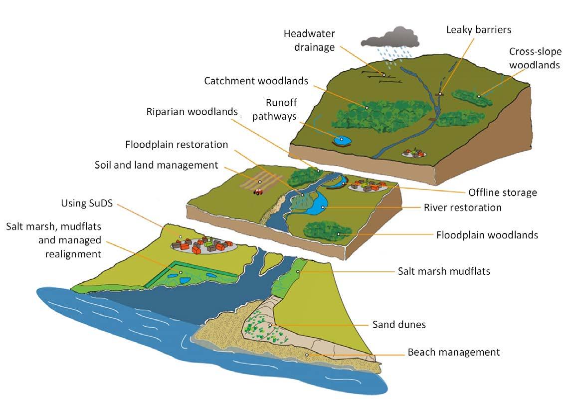
228.NFM can reduce water flows through the catchment, research however indicates it may not be so effective in isolation, or during extreme flood events. It can be effective in larger catchment scale projects or when used in conjunction with more traditional interventions, acting to reduce and delay peak flows, so reducing the risk of other defences failing or being overtopped. In these cases, the use of NFM can result in smaller and less obtrusive hard defences being required within the catchment. We refer to such a mix of methods as hybrid schemes.
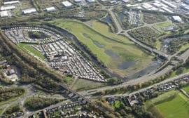
Swansea Vale Flood Storage Area
231. The Welsh Government’s FCERM Business Case
Guidance states that RMAs must consider the use of NFM in developing options for new assets and maintenance. 232.There has been significant research into NFM since the publication of the previous National Strategy. The
“Working with Natural Processes” research57, Natural Flood
Management Handbook (SEPA)58 and “Green approaches in river engineering”59 provide case studies and information which RMAs may find helpful to better understand where and how certain types of interventions may work. 229.NFM and/or hybrid schemes are eligible for FCERM grant funding as long as the objective is to reduce flood risk to properties; see chapter 6. 230.The flood alleviation scheme in Swansea Vale incorporated a flood storage area and re-naturalised the flood plain for both biodiversity and amenity benefit. It is an example of a fluvial hybrid intervention which the Welsh Government is keen to support.
Completed in 2014, this £6.9 million scheme made space for water by forming new earth embankments creating an area to hold flood water from the River Tawe and its tributaries during flood events. As well as raised embankments the scheme creates more space for water by setting back the flood defences at the top end of the river and taking out three redundant bridges to allow more water to pass. The NRW scheme has provided wider benefits such as the creation of a natural wetland area which has enhanced 6ha of brownfield industrial land as green space for local people to enjoy and new habitat to support wildlife. 3km of National Cycle Network was upgraded along the river including a new footbridge.
233. NRW have published maps60 to support the delivery of
NFM, identifying potential locations for such measures in a catchment. The maps have been made available as open data and should be used as the basis for starting conversations about NFM as a collaborative catchmentbased approach in conjunction with other RMAs and partners.
57 www.gov.uk/government/publications/working-with-natural-processes-to-reduce-flood-risk 58 www.sepa.org.uk/media/163560/sepa-natural-flood-management-handbook1.pdf 59 Green approaches in river engineering – supporting implementation of Green Infrastructure. Roca et al. HR Wallingford, (2017) 60 naturalresources.wales/flooding/managing-flood-risk/maps-for-natural-flood-management/?lang=en
Gurnos Woods, Powys – Small Scale Scheme/ Natural Flood Management
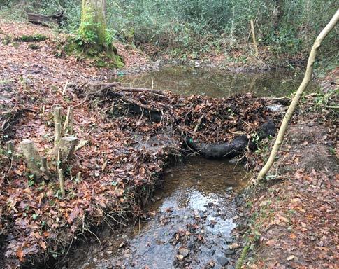
Powys County Council have installed a series of green engineering measures to reduce flooding associated with a small watercourse in Ystradgynlais. Prior to the scheme, the culvert system could not cope with flows and was blocking due to silt and stone washing downstream. The works undertaken involved the construction of leaky dams, straw bale dams and willow structures to slow down the flow of water. Block stones have also been installed to reduce the force of the water and prevent erosion of the embankments. Powys have monitored these interventions since construction and have witnessed a number of significant benefits: all debris is being held behind each structure reducing blockages; flows within the channel are clearer allowing for increased wildlife to the area; reduced peak flows of flood waters and reduced erosion of the embankments.
234. As well as reduction in flood risk, NFM may provide wider benefits such as carbon storage, recreation, biodiversity improvements and social wellbeing. The use of these measures can also help RMAs demonstrate delivery against the Well-being of Future Generations (Wales)
Act, and duties under the Environment Wales Act, as they encourage an integrated approach to delivery and provide opportunities for collaboration with neighbouring authorities and land owners. 235.We want to improve our understanding of the benefits of NFM, particularly on performance and long term maintenance requirements. We will continue to engage in research in this field and encourage RMAs to monitor outcomes of NFM to understand its benefits and to feed into research where appropriate. 236.We will encourage further take-up by introducing full grant support for NFM schemes for at least two years, commencing 2020/21. A key element of this additional support is monitoring outcomes and sharing experiences in its use with other RMAs so that we can learn lessons on all stages of NFM delivery. 237. NFM measures are already being implemented across
Wales61. Drawing on lessons learnt and ongoing research62 into this area will help to improve our wider understanding of the impact and effectiveness of different measures in various locations and scales. This will help inform future best practice and aid investment decisions, and we expect
RMAs to share their experiences and research through existing groups and fora. 238.Future land management policy63 is currently being devised to replace the Common Agricultural Policy once the UK has exited the EU. It focuses on the delivery of environmental public goods such as targeted interventions to reduce flood risk. This initiative is likely to widen the implementation of NFM, including by those without direct responsibility for flood risk management. 239. This Strategy complements forestry and agriculture policies to help reduce flood risk through reduced run off, and for appropriate tree planting, ploughing and cultivation practices to be encouraged for the same reason. The benefits of tree planting in appropriate parts of a catchment are still being understood, but research64 is demonstrating that it does reduce risk and provide biodiversity benefits as part of a package of measures.
61 naturalresources.wales/media/680131/flood-coastal-erosion-risk-management-in-wales-2014-2016.pdf 62 www.nerc.ac.uk/research/funded/programmes/nfm/ 63 gov.wales/brexit-and-our-land-our-response 64 Research on the impact of tree planting on flood risk is documented in the Working With Natural processes Evidence Directory – www.gov.uk/government/publications/working-with-natural-processes-to-reduce-flood-risk including a case study at Pontbren.
Green-grey infrastructure 240.We acknowledge the importance of green-grey interventions in flood alleviation and coastal erosion.
We want to see FCERM infrastructure become more sustainable in the long term and work increasingly in conjunction with nature based solutions to improve resilience and provide wider benefits to ecosystems.
Vertipools, Isle of Wight66

241. Green-grey interventions include a natural component to improve the biodiversity, ecology and aesthetics of an engineered structure whilst maintaining the integrity of the defence. It can be described as naturalising hard structures to mimic the natural environment. They can create space for recreation and help with climate change mitigation and adaptation or incorporate natural habitat, such as mud flats or salt marsh, into an FCERM scheme. Examples include adding features defences, such as concrete units which mimic rock pools, or building texture into sea walls and river embankments to encourage biodiversity65 . 66
Vertipools have been attached to the side of dock in Fishbourne, Isle of Wight in 2017 during an investment project to improve ferry and port facilities. They provide an artificial rock pool which retain water as the tide recedes providing a habitat for fish and invertebrates. Marine life which colonise the pools can also strengthen the integrity of the structure and improve its resilience by providing a covering of organisms such as barnacles, mussels and seaweeds. They are also used for educational purposes allowing local school children on fieldtrips to undertake rock pooling activities and learn about marine biology.
242.Research such as ‘Integrated Green Grey Infrastructure’67 (IGGI) demonstrates opportunities to ‘green the grey’ and add wider benefits to a traditional scheme. Like NFM, green-grey infrastructure should be considered when planning new defences or during maintenance of existing defences and is grant eligible.
We want to encourage the take-up of NFM in Wales. We will support pilot studies and interventions designed to reduce flood and coastal erosion risk to better understand its benefits.
MEASURE 13: The Welsh Government will fully fund NFM schemes for a trial period, commencing 2020/21, and publish new guidance to further encourage take-up and the sharing of lessons on its practical delivery.
MEASURE 14: The Welsh Government will work cross policy to ensure NFM is considered in wider land and water management, including agriculture and in NRW Area Statements.
Objectives supported: A, B and C
We want to see NFM as an option for every FCERM scheme as set out in our FCERM Business Case Guidance.
MEASURE 15: The number of NFM and hybrid schemes undertaken will be reported to the Welsh Government annually through grant reporting, and reported to Welsh Ministers by NRW in the Section 18 report.
Objectives supported: A, B and C
65 Living Flood Defence Walls: Reconciliation Ecology in an Urban Estuary” Francis et al. (2015). Technical Report. 66 www.artecology.space/wightlink 67 Naylor, L. A., Kippen, H., Coombes, M. A., Horton, B., MacArthur, M. and Jackson, N. (2017) Greening the Grey: A Framework for Integrated Green Grey
Infrastructure (IGGI). Technical Report. University of Glasgow, Glasgow

