
13 minute read
Objective D: Preventing more people becoming exposed to risk


Objective D: Preventing more people becoming exposed to risk
243. The focus of FCERM is justifiably on reducing risk to communities located in at-risk areas. Historically, development along rivers, estuaries and the coast has been required for trade, economic or agricultural purposes but has, over time, put people at increasing risk from flooding. Advances in engineering and construction mean some of those dangers can be managed, but some risk always remains and as this grows it may require expensive alleviation schemes and constant maintenance to keep people safe. 244. With better, more open, flood data, we can make more informed decisions on where to develop and how to adapt our communities to actively remove elements of risk. We can also provide the public with the information they need to understand how flooding may affect them so they can make their own choices on avoiding or managing their own personal risk. 245.This new objective underlines the importance of sensible decision-making, from personal choices to government policies, so as not to further increase flood or coastal erosion risk or store up problems for the future.
Managing development risk 246.Planning plays a crucial role in managing development to avoid inappropriate siting, reduce flood risk where possible and not increase risk elsewhere. The Welsh Government’s policy of directing development away from areas at high risk of flooding and managing water is set out in Planning
Policy Wales and Technical Advice Note (TAN) 15 which complements this Strategy. 247. Flood risk must be considered at the earliest opportunity not only to avoid inappropriate development but also to enable the sustainable management of water into new housing development. The statutory requirement for
Sustainable Drainage Systems (SuDS) in managing runoff helps reduce flooding risk, on site and further down catchment, relieving pressure on drainage systems and improving water quality. 248. In January 2019, SuDS68 became a mandatory requirement for the management of surface water on new developments. This fully reflects the need to protect and enhance the environment, in a controlled way similar to a natural process. 249. This all forms a vital part to the response in adapting to climate change and helping to achieve sustainable development. SuDS can also create opportunities for biodiversity improvements and recreation, as highlighted by Public Health Wales, amongst others, in improving health and mental well-being69 . 250.Evidence also suggests good quality SuDS may contribute to reduced or sequestered greenhouse gas emissions, providing important benefits for climate change mitigation.
We will ensure the requirement for SuDS in new properties is being implemented and working as intended.
MEASURE 16: The Welsh Government to commence a review of the effectiveness of SuDS legislation in 2021
Objectives supported: B and C
251. Development in coastal areas requires additional considerations which take into account the characteristics and challenges posed by such a location. In addition to flood and coastal erosion risk, the SMPs are a material consideration for Local Development Plans and development decisions in coastal locations. Further advice is contained in paragraphs 155-166 and within TAN 15. 252.TAN 15 will provide clearer and more robust policy advice on managing areas at high and medium flood risk. There is a careful balance to be struck as some development on flood plains may still be necessary due to the way our towns and cities have grown around rivers, estuaries and the coast. An outright ban on all flood plain development would sterilise growth in and around most of our populated areas, and lead to increased pressures to allow development on agricultural land and other greenfield areas. 253.TAN 15 proposes a new higher-risk zone where vulnerable development, such as new homes, cannot be located. It also sets clear tests to allow resilient development into appropriate lower-risk areas when safe to do so and where it will not increase flood risk elsewhere. Such a risk-based approach complements this Strategy, and will help to reduce the number of people living in high and medium flood risk areas. It also ensures the Welsh Government upholds its part of the Flood Re insurance agreements70 . 254.FCERM schemes should not be considered in defending land for the development of new homes (see paragraphs 220-221), reinforcing our policies to discourage inappropriate development in higher risk areas.
68 Schedule 3 to the Flood and Water Management Act 2010 makes provisions for sustainable drainage. Details of the regulatory framework and Statutory SuDS Standards and guidance are available at: gov.wales/sites/default/files/publications/2019-06/statutory-guidance.pdf 69 A summary of links between open space and health can be found at: Green Space and Health (2016) researchbriefings.files.parliament.uk/documents/POST-PN-0538/POST-PN-0538.pdf 70 Consultation stage Memorandum of Understanding, Water Bill, 2013 consult.defra.gov.uk/flooding/floodinsurance/supporting_documents/20130626%20
Flood%20Insurance%20MOU%20June%202013%20unprotected.pdf
255.Managing development in relation to flood risk relies on the most current information being available for advice and strategic decisions. TAN 15 will use the Wales Flood
Map as the key source of flood advice for planners, withdrawing the previously used Development Advice
Map to help stop any confusion over which map to use or which is most up-to-date. NRW are responsible for managing and updating the Wales Flood Map, providing clarity to the public and planners alike. However all RMAs have a role to play in providing asset data to NRW, as described earlier in this chapter, to ensure decisions are made using the most up-to-date information.
We want Planning and FCERM policies to complement each other, reducing risk by preventing inappropriate development in the flood plain and helping Planning Authorities make clear decisions based upon the best available information.
MEASURE 17: The Welsh Government to update TAN 15 by 2021 recognising the flood risk information now available to Local Planning Authorities
Objectives supported: B and D Coastal adaptation 256.Coastal adaptation is the process of adjustment, to manage the increasing risks to coastal areas associated with climate change. However, many of the same principles apply to communities away from the coast, alongside rivers or in places prone to heightened surface water run-off and flash flooding. 257. Our understanding of climate change is improving all the time, but we know it will result in rising sea levels and more intense storm events putting coastal communities at increasing risk. SMPs complement national policy and set out the agreed options to sustainably manage our coast over the next 100 years. Text earlier in this chapter gives more detail on SMP policies. 258.Coastal interventions should be adaptive and sensitive to the environment they sit within as well as providing adequate protection to the communities they serve. The need to plan for coastal adaptation is particularly important for communities where SMP policies will change from
‘holding the line’ to ‘managed realignment or ‘no active intervention’. 259.We have established the Coastal Risk Management
Programme to provide funding to Local Authorities between 2019 and 2022 for coastal adaptation and risk management in line with the SMPs and in acceptance of the increasing risk coastal communities face from climate change. 260.We cannot defend our entire coastline. There will be instances where it becomes unsustainable or counter-productive to maintain some defences in their present position. Defences can also lead to coastal squeeze of intertidal habitats and may increase sediment or beach loss by concentrating erosion or scour. Large populated areas are likely to remain reliant upon some form of coastal infrastructure (as well as fluvial). However, it is important to note they do not remove all risk; there remains the chance of catastrophic failure of a defence, significant overtopping or groundwater flooding. 261. Coastal Local Authorities, NRW and private asset owners should consider how infrastructure can be adapted to higher sea levels before the risk becomes excessive.
Similarly, RMAs should consider how to implement a change in coastal management long before the SMP indicates it. Monitoring of coastal processes is an essential part of this so that the RMAs are well informed of increasing risk and can manage and communicate that risk to the community well in advance.
Fairbourne, Gwynedd
Difficult decisions are being made where communities are facing rising sea levels and increased storminess which come with a warming climate. Fairbourne, Gwynedd, is an example of this, sitting on a low-lying sand-bar behind coastal and estuarine defences which will become increasingly difficult to manage. The defences have been earmarked for managed realignment in the SMP as this is considered the most sustainable solution to keep residents safe in the long-term. Fairbourne has received considerable media attention, however, such issues are not confined to this village; there are communities across the UK which will face similar risks and difficult decisions over the next century. In Wales, 95 coastal areas will move from a ‘holding the line’ policy (defending) to ‘no active intervention’ or ‘managed realignment’ by 2100. Around 40 of those areas may require relocation of property. A policy of managed realignment does not mean the complete withdrawal of support. The Welsh Government continue to provide funding for defences, maintenance and adaptation studies in Fairbourne. Since 2013, £8 million has been invested to keep its residents safe, plan ahead and adapt. Ongoing research is also helping us to understand impacts and how similar communities can be supported through an adaptation process. We recognise the wider influence such policies have on people and across Government. Such change has widespread social, economic and environmental effects, both directly or indirectly, through a need to adapt, relocate or invest in greater resilience. The impact of such strategic and long-term adaptation has been highlighted as the media share SMP findings and risk data to a wider audience. We have learnt lessons about communicating difficult messages and remain committed to being open and transparent. We believe it is preferable to work together with communities, preventing risk and planning ahead for the next century, than to withhold information on flood or coastal erosion.
262.We support the role of nature based solutions in managing coastal flooding, erosion and adapting to climate change in line with the policies set out in SMPs. This may offer alternative opportunities in areas where defences will be realigned, or a step away from routine maintenance towards a more natural coastline. 263.The Welsh Government has established a Wales Coastal
Monitoring Centre (WCMC) to provide coastal authorities with consistent and reliable data on processes and helping to understand longer-term trends (see paragraph 148). 264.Adaptation planning should take into account the timing of the proposed action. Acting too soon can risk disruption in communities at risk, but acting too late risks impacts in those areas. Providing clear information and evidence is key so that residents and businesses are aware of decisions which may affect them and can become involved in the long-term planning which may bring change to their coastline and community.
Examples of interactive coastal adaptation from Pays Basque, France
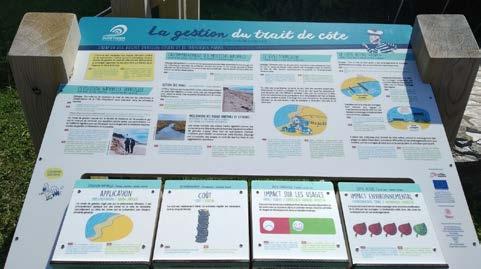

The town of Bidart and neighbouring beaches in the Basque Region have introduced interactive noticeboards to help illustrate some of the different ways coastline adaptation can be managed, along with costs and impacts on people and the environment.

265.The Coastal Groups should prioritise those communities where engagement is needed to communicate coastal adaptation messages and develop adaptation plans where there is a change to a No Active Intervention or Managed
Realignment policy. 266.Local Authorities are expected to take SMPs into account through their Local Development Plans and in their Local
Flood Risk Management Strategies. 267. The Welsh Government’s preference is for the SMP position for each section of the coast to be supported in
Strategic and Local Development Plans and Strategies relating to infrastructure or activity on the coast such as marine planning, agriculture or housing. SMPs are a material consideration in Local Development Plans and it is right for such strategic, long term policies to be placed in that context so that they can be considered in forward planning and shaping development around the
Welsh coast. In developing a plan for coastal adaptation,
Local Authorities shall communicate the SMP policy and timescales across relevant departments and stakeholders. 268.Where new information becomes available that may influence an SMP policy for a stretch of coastline, it should be reviewed by the Local Authority and relevant Coastal
Group. Information on how and why SMP policies should be amended at a local scale is outlined earlier in this chapter. 269.Where major populations and critical infrastructure dictate reliance upon hard defences, consideration should be made to lessen risk by building resilience in those communities through supportive measures, such as a flood plan. Further coastal interventions may also be required such as beach nourishment or breakwaters to absorb wave energy and further reduce risk. 270.We recognise a need for further guidance on communicating SMP policies and will work with stakeholders to develop Coastal Adaptation Guidance, informed by ongoing research in places like Fairbourne,
Gwynedd, to provide practical advice to practitioners and communities.
We need clear advice on coastal adaptation for Risk Management Authorities and communities
MEASURE 18: The Welsh Government to work with the Coastal Groups and NRW to develop further guidance on coastal adaptation by 2022
Objectives supported: A, B and D
271. Climate change can result in coastal squeeze: the loss of coastal habitat as a result of sea level rise against infrastructure, rising land or cliffs. Whilst we prioritise the protection of coastline to reduce the consequences for communities and people, there is a need to recognise the impact of sea level rise on the environment and economy of Wales. The definition of coastal squeeze and how it is measured has been the subject of recent research71 supported by the Welsh Government. 272.The National Habitat Creation Programme is a Welsh
Government initiative managed by NRW. It has been established to compensate for the coastal squeeze associated with new Local Authority and NRW schemes which implement ‘hold the line’ or ‘advance the line’ policies in SMPs, helping to meet our responsibilities under the Habitats Directive (EU) and Habitats Regulations. 273.The Habitats Directive72 requires EU Member States to monitor the conservation status of European protected habitats. The Welsh Government has asked NRW to undertake this role as part of the National Habitat Creation
Programme. 274.NRW manage the National Habitat Creation Programme in delivering timely and appropriate compensatory measures to address coastal squeeze losses. The requirements for compensatory measures and progress with delivery including extent, habitat type and location need to be reported annually.
Cwm Ivy, Salt Marsh Creation

275.Whilst NRW manage the National Habitat Creation
Programme, its success is dependent upon support from all
RMAs. In line with the Wellbeing of Future GenerationsAct we ask all RMAs in Wales to collaborate towards this goal, identifying and contributing compensatory habitat.
NRW will manage the requirements for the National Habitat Creation Programme.
MEASURE 19: NRW to develop and establish an appropriate monitoring programme to support and inform the National Habitat Creation Programme by 2022
Objectives supported: C
Cwm Ivy Marsh, on the North Gower coast, is a site of lowland fen meadow and freshwater ditches behind a sea wall defence, owned by the National Trust. The SMP policy for this section of the coast is No Active Intervention, with no planned investment in new defences as it is not cost effective and the natural environment is considered capable of responding effectively. The marsh was protected by a sea wall since the 17th century which over the years was increased in size and strength. In 2014, the wall breached and the sea is now reclaiming the land, transforming Cwm Ivy from freshwater marsh to saltmarsh. The area of new saltmarsh created is around 20 hectares, growing to a potential of 38 hectares.

