I d id al u ur Infilll sideen withhCCo ithC rci a ith th m rcial m rc c ciaal
C l olu m n e Arcca
F t r ure
f I i l ll
R e i e s d n
e t i l
Cres Cr Crereessweweelll
Ha ll a l
i Muultlttiippuurrp c e
trianTransitWay
er n t
AN ADVOCATE FOR OUTDOOR LIVING ROOMS
INTERESTS & EXPERIENCE:
Human-Oriented Urban Design
Sociable Public Spaces
New Mobility Street Solutions
Downtown Master Planning
Park & Trail Master Planning
Public Outreach & Community Input
TECHNICAL SKILLS:
Urban Plaza Design Specialist
Organizational Leadership
3-D and Photo Simulations
Public Speaking & Facilitation
Geographic Information Systems
CAD/Sketchup/Lumion/CityEngine
Hand-Sketching Concepts & Plans
c i t y s q uare s u rban p laza s p lacemakin g h u m an-sca l ed
c ommunit y ident it y p eo p l e p l a c e s p ublic life eco n o mi c stimulu s socia l e q u ity a ctive trans p ortio n
“What is the city but the people?”
William Shakespeare
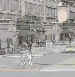
NEW MOBILITY SIMULATIONS
City of Leucadia, California
More San Diego municipalities are requesting active transportation, roundabouts, and larger transportation hubs. The city of Leucadia is hitting all three by incorporating major improvements at two key intersections along coast Highway 101. These improvements met and exceeded the latest in NACTO transportation standards.
These renderings utilized the latest in 3D rendering software, Lumion, along with Photoshop for the final touches.
San Diego
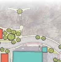
SWEETWATER PARK MASTER PLAN
Chula Vista, California
A new community center was proposed for the city of Santee, and decisionmakers needed to visualize the landscape treatment surrounding the proposed buildings.
ACTIVE TRANSPORTATION/NEW MOBILITY SOLUTIONS
National City, California
National City is a front-runner in San Diego County municipalities, in that it has vision of what a multi-modal community can be. Our firm was hired to produce a full active transportation master plan, which incorporated the latest bike and crossing solutions, curb management, and mini and large transportation hubs.
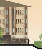
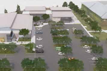
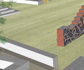
SANTEE COMMUNITY CENTER Santee, California
A new community center was proposed for the city of Santee, and decisionmakers needed to visualize the landscape treatment surrounding the proposed buildings.
These renderings utilized the latest in 3D rendering software, Lumion, along with Photoshop for the final touches.
A GREEN INFRASTRUCTURE MASTER PLAN
St. Marys, Georgia
Through a intensive public input process by our studio, a comprehensive vision was created for the coastal community of St Marys. Using greenwater infrastructure, this plan introduces walkable and beautifying elements throughout the streets of their downtown district.
A noteworthy elemenent included a intertidal stormwater estuary, located at the absolute low-point, which addressed both stormwater as well as the perioding “nuisance flooding” that occured at extreme high tides.
Spectrum Studio at the Carl Vinson Institute of Governments
A DOWNTOWN VISION
Villa Rica, Georgia
Through an intensive public input process, the City of Villa Rica contracted my studio to provide an overall vision of what the city’s downtown may look like.
This plan included a civic plaza space, a skate park adjacent to the city’s ampitheater, and a four-story infill development, as well as a streetscaping plan.
New Mill Civic Plaza
Spectrum Studio at the Carl Vinson Institute of Governments
New Municipal Skate Park
Corner Mixed-Use Development and Streetscaping Plan
MIXED-USE INFILL SOLUTIONS
Conyers, Georgia
The city of Conyers, Georgia contracted my studio to develop a strategic visioning and master plan for their downtown.
The resulting proposals included several compact mixed-use developments in formerly underutilized parcels.
In addition, these will have direct walkable connections to their existing downtown.
Spectrum Studio at the Carl Vinson Institute of Governments
DEFINING A NEW DOWNTOWN HUB
Clarkesville, Georgia
The city of Clarkesville, Georgia lost their once prominent city square to highways that cut through downtown.
This bold concept proposes to shift the urban hub to an underutilized area on within the western edge of downtown.
This innovative proposal was the result of a public input process to identify residents’ priorities:
• economic expansion
• provide event spaces
• recreate their historic square
• expand walkability
• visitor lodging
• diverse restaurant selection
• amenities for the young
• connection with a riverfront park
Worked with the Spectrum Studio at the Carl Vinson Institute of Governments University of Georgia, Athens, Georgia
New Courthouse Square Community
ATHENS INFILL MASTER PLAN ~ RIVERFRONT
Athens, Georgia
To meet the long-term needs of Athens, Georgia. An infill master plan was conceived on the edge of downtown. This included an activated riverfront and pedestrian community, planned in two phases.
UNIVERSITY OF GEORGIA
PEDESTRIAN COMMUNITY
RIVERFRONT PLAN
CO MMUNITY
RIVERFRONT
DOWNTOWN ATHENS
This stretch of underutilized riverfront offers a link between downtown Athens and the North Oconee River.
Based firmly in best practices for successful waterfronts, I proposed:
• limited private residential development
• mixed-use buildings
• numerous public spaces
• traffic-calming measures
• multiple attractions
• easy access by boat, bike, and foot
• ecologically-restored portion of riverfront
Second Year Studio
View to Waterfront Dock
Flower Demonstration Garden
ATHENS INFILL MASTER PLAN ~ PEDESTRIAN COMMUNITY
Athens, Georgia
Plaza Space in North End of Community
A large, abandoned property offered an opportunity for urban infill on the edge of downtown Athens, Georgia.
This place would be an extension of the downtown district, yet have it’s own identity.
Building Uses
I proposed a pedestrian-oriented community accessible from downtown, as well as by a proposed light-rail line and bike corridor.
This design features internal public spaces surrounded by dense, mixed-use buildings facing inward.
Second Year Studio
At the center of Athens, Georgia is a single section of street that is the social gravitational center of downtown. Traffic volumes here are low and present an opportunity for a new public space.
Taking advantage of the live music legacy in Athens, my leading goal was to design a space that can facilitate a number of uses throughout each, as well as host spontaneous music acts.
I provided sitting steps and overhead shading to experience the musical performances comfortably.
A SOCIABLE SQUARE ON COLLEGE AVENUE Athens, Georgia
CONCEIVING KETTLE CREEK BATTLEFIELD PARK
Wilkes County, Georgia
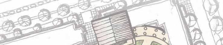
I served as the lead planner and designer of a conceptual master plan for a future historic park, where a key Revolutionary War battle took place in 1779. I coordinated frequently with local historians, engineers, and elected officials in this effort.
The goals were to enhance the access and interpretation of the story that took place here, as well as provide facilities for passive recreation.
Governments
Sample of Master Plan
Spectrum Studio at the Carl Vinson Institute of
Self-Guided Botanic Tours
Self-Guided Historic Tours
Picnic Pavilions
PARK(ING) DAY 2015
Athens, Georgia
I led the planning, design, and installation of a temporary pocket park throughout three parallel parking spaces in downtown Athens, Georgia. This one-day event highlights the need for public space for human activity rather than for parking. This was a student-run effort and the result of a partnership between our college, the city, and the university.
MUNICIPAL PARK MASTER PLAN
Domed Botanic Conservatories
Our advanced studio was invited to design and program a large land holding intended for a municipal park.
Nestled between mediumdensity residential and schools, I proposed
This concept offers the city a vital educational and ecological amenity, featuring:
• planetarium and observatory
• botanic conservatory
• outdoor classrooms
• demonstration gardens
• restored native forest walks
• light-rail system access Observatory/Planetarium Complex
DRAWING EXPLORATIONS
Cortona, Italy
The medieval Tuscan city of Cortona, Italy served as the perfect subject to highlight the harmony between natural systems and daily human life.
These ancient Italian cities, with their vibrant streets and piazzas, were my living classrooms.
Here I learned the planning and design principlesto make great streets and socially-vibrant public spaces.
We then applied what we learned to projects located in our temporary home of Cortona.
URBAN DESIGN IN ITALY
Samples of Construction Detail Sheets
The elements featured here provide the construction details for a outdoor plaza space serving as a relaxation area for office employees.
I included a tall, long seatwall bordering a natural stone-paved space, a lower space to hold a seating table, and a wooden boardwalk bridge to access this space across a small ravine.
Mitigation Landscape Plan
Wellington, New Zealand, July 2017
1. Driveway and building footprints set in the Scheme plan by Envelope Engineering in the LVA.
2. Drainage easement for stormwater and wastewater pipes, 0.5m-1m below the surface.
3. part of the mitigation planting.
Proposed Trees for Mitigation Planting
Proposed Shrubs up to 3m Height
Proposed Shrubs up to 1.5m Height
4. Particular care is made to increase visibility around the bend of Parkvale Road in front of Lot 1 by thinning out an appropriate amount of
A.
This space can be viewed as a transition between a rural landscape and a quiet, residential community. To that end, a general planting strategy throughout the subject area is proposed that establishes a visual appearance
Proposed Trees for Planting
Retained
Proposed Shrubs up to 3m Height (refer to planting palette table)
Proposed Shrubs up to 1.5m Height (refer to planting palette table)
Proposed Subdivision Boundaries
Corynocarpus laevigatus (karaka) native evergreen15m3.6mPlant at two locations along north side of property.2
Carpodetus serratus (putaputaweta; marbleleaf) small native tree 10m3-4mPlant at four locations along south edge of property.4
Pittosporum Tenuifolium (kohuhu) native evergreen shrub3m3m Fast growing and adaptable, can be ornamental (1.5-3m spacing), or as a hedge (80cm-1m spacing).
Corokia spp. (korokio) native shrub3mvariable1.5m spacing, used for hedgerows
Westringia spp.fast-growing shrub 1.5 to 2m up to 4m or specimen (200-400cm spacing)
Hebe diosmifolia native evergreen shrub with rounded form 1m1mfast growing, full sun.
Pimelea prostrata (New Zealand Daphne) native evergreen groundcover 0.11.2fast growing and compact, good for mass planting, hardy.
m2
m2
residential development when viewed from all angles, while also providing some rural character.
to soften the visual impact of the proposed structures when viewed from the Skyline Track above the site, as well as the view along the road in front of 170 Parkvale.
Screening and softening of the entire site can be achieved by the retention of certain native trees along the property edge along the road.
The subdivision boundaries are provided by ‘Envelope Engineering’. Refer to their plans for more information.
This plan is intended solely for the use of the client in accordance with the agreed scope of works.
Information contained within this drawing is the sole copyright of Align Ltd and is not to be reproduced without their permission.
Construction Drawings, Planting Plan and stage of works.
site prior to commencing any work.
All trees are to be a minimum of 1.5m at the time of planting, and shrubs are to be a minimum of pB8 in grade.
LOCATION MAP
PLANTING PALETTE TABLE
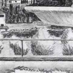
Boboli Gardens, Florence, Italy
c i t y s q uare s
u rban p laza s
p lacemakin g
human-scaled
c ommunity identity p eo p le p lace s p ublic life