
CHUL PARK GIS + URBAN PLANNING + DESIGN PORTFOLIO +65 93578613 chpark4087@gmail.com
SINGAPORE - EXPLORATION OF AVAILABLE GIS LAYERS

Masterplan 2019 and its land use
Agriculture Beach
Business 1
Business 2
Business Park
Cemetery
Civic and Community Commercial
Commercial / Instiution
Commercial & Residential Educational Institution
Health & Medical Care
Hotel
Open Space Park Place of Worship
Port/Airport Reserve Site Residential Residential/Institution
Residential with Commercial Road Special Use Waterbody
SINGAPORE - EXPLORATION OF AVAILABLE GIS LAYERS
Coastal habitat layer from Nparks showing the major biodiversity area islandwide observed from a high resolution satelite image.
 Coastal Habitat
SINGAPORE - EXPLORATION OF AVAILABLE GIS LAYERS
Box Plot and Scatter Plot showing the distribution of land are in HA for dfferent land use in MP 19. Comparing the two different plot styles help layman with minimal statistics understanding to see the distribution.


SINGAPORE - EXPLORATION OF
* Median Value
AVAILABLE GIS LAYERS
Box Plot of all the land use in MP19 as a benchmark study for future planning works

2.0 1.2 0.1 0.1 0.5 0.7 0.8 1.5 0.4 0.4 0.1 0.01 0.03 0.02 1.8 5.3

0.1 0.7 0.3 0.4 0.2 1.5 0.9 0.03 0.01 0.02 0.5 19.2 1.7 0.2 0.1 0.4 0.9
SINGAPORE - EXPLORATION OF AVAILABLE GIS LAYERS

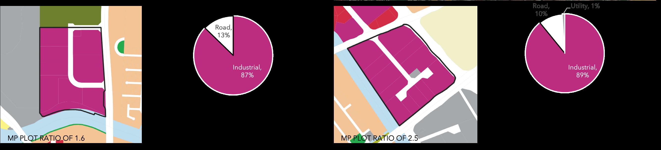
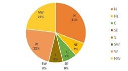
Prelimanry observation of masterplan19 plot ratio distirbution in relation to 400m buffer around the masterplan MRT and LRT stations.
Masterplan Plot Ratio
0-1 1-2 2-3 3-4 4-5 5 <
SINGAPORE - EXPLORATION
OF AVAILABLE GIS LAYERS
MRT Lines
400m buffer MRT
East West Line
Cross Island Line
Jurong Region Line

North South Line
Downtown Line
Circle Line
Thomson-East Coast Line
North East Line
LRT
MP19 MRT layers with 400m buffer around the station box.SINGAPORE - EXPLORATION
Supervised classification utilizing Semi Automatic Classification to derive on preliminary remote sensing output.
OF AVAILABLE GIS LAYERS

SINGAPORE - EXPLORATION OF
Unsupervised classification utilizing Semi Automatic Classification to derive on preliminary remote sensing output.
AVAILABLE GIS LAYERS

SINGAPORE - EXPLORATION OF AVAILABLE GIS LAYERS

0 10 20 30 40 50 60 70 80 Meter above sea level
Elevation map generated from SRTM dataset which dates back to 2012.
SINGAPORE - EXPLORATION
A kernal density heatmap, utilizing the existing grocery stores such as fariprice NTUC and Shergsiong’s geographic information extracted from google earth.

OF AVAILABLE GIS LAYERS
KERNAL DENISTY HIGH LOW

SINGAPORE - EXPLORATION OF AVAILABLE GIS LAYERS

Projected sea level rise scenarios utilizing the SRTM topo information based on the sea level scenario from Climate Central.
 1.5 °C Increase
2.9 m Global Sea Level Rise
2.0 °C Increase
4.7 m Global Sea Level Rise
1.5 °C Increase
2.9 m Global Sea Level Rise
2.0 °C Increase
4.7 m Global Sea Level Rise
Future at risk area from sea level rise by 2100


3.0
6.4
4.0
10.8m
°C Increase
m Global Sea Level Rise
°C Increase
Global Sea Level Rise
SINGAPORE - LOGISTICS PARK
There are a few logistics park estates in Singapore that are spread out across the island. The land area for these Logistic Parks ranges from 22AC (9HA) to 90 AC(37HA). Clementi West Logispark and Changi International Logispark are similar in size to the project site.


 CLEMENTI WEST LOGISPARK- 38 AC (15 HA)
CHANGI INTERNATIONAL LOGISPARK (SOUTH) - 32 AC (13 HA)
CLEMENTI WEST LOGISPARK- 38 AC (15 HA)
CHANGI INTERNATIONAL LOGISPARK (SOUTH) - 32 AC (13 HA)
TOPOGRAPHIC ANALYSES


Topographic Elevation Map For A Site In Lahore,Pakistan


Topographic Slope Analysis Map For A Site In Lahore,Pakistan
Topographic Elevation Map For A Site In Sohar,Oman
Topographic Slope Anlysis Map For A Site In Sohar ,Oman


Topographic Elevation Map For A Site In Lahore,Pakistan
Topographic Elevation Map A Site In Lahore,Pakistan

Topographic Elevation Map For A Site In Ashanti,Ghana

Topographic Elevation Map A Site In Ashanti , Ghana


RENDERING OF LOGISTIC PARK IN PAKISTAN
 Aerial rendering developed from Sketchup and Vray illlustrating an urban simulation of the logisitc park in Lahore, Pakistan.
 Aerial rendering developed from Sketchup and Vray illlustrating an urban simulation of the logisitc park in Lahore, Pakistan.
QUANGTRI SPECIAL ECONOMIC ZONE

QUANGTRI SPECIAL ECONOMIC ZONE
ANALYSIS OF EXISTING CONDITIONS
Existing Land Use Plan

Committed Projects
Existing Settlements
Waterlogged Land
Sea Level Rise Scenarios

Slope Analysis
The following layers were taken into consideration during the master plan review process for a sustainable and resilient development..
Elevation
QUANGTRI SPECIAL ECONOMIC ZONE
PROPOSED STORMWATER AND DRAINAGE STRATEGY
PROPOSED STORMWATER AND DRAINAGE STRATEGY


Urban Edge
Stormwater collection in Buildings


Naturalized Edge
Section Profile Not to Scale/ Based on open source information
Section Profile Not to Scale/ Based on open source information
TOURISM RESIDENTIAL HI-TECH AGRICULTURE INDUSTRIAL PARK AND OPEN SPACE RESIDENTIAL TOURISM SEA
TOURISM RESIDENTIAL HI-TECH AGRICULTURE INDUSTRIAL PARK AND OPEN SPACE RESIDENTIAL TOURISM SEA
QUANGTRI SPECIAL ECONOMIC ZONE

DALIAN DIAMOND BAY -
GIS analysis to assess the efficacy of the different land use plan options to determine the one with highest scoring.

SUSTAINABLE SYSTEM INTEGRATION
MODEL
DALIAN DIAMOND BAY - SUSTAINABLE SYSTEM INTEGRATION MODEL

DALIAN DIAMOND BAY - Sustainable System Integration Model

GIS analysis breakdown in more detail for the original masterplan


N1 S1 N2 S2 G1 T1 G2 T2 G3 T3 PEDESTRIAN NETWORK MIXED USE PROPORTION BICYCLE NETWORK PUBLIC FACILITY ACCESSIBILITY WATERFRONT UTILIZATION RESIDENTIAL TRANSIT ACCESSIBILITY PARK ACCESSIBILITY WORKPLACE TRANSIT ACCESSIBILITY PARK CONNECTIVITY TOD LAND USE TYPES
DALIAN DIAMOND BAY - Sustainable System Integration Model

GIS analysis breakdown in more detail for the proposed option 2.


N1 S1 N2 S2 G1 T1 G2 T2 G3 T3 PEDESTRIAN NETWORK MIXED USE PROPORTION BICYCLE NETWORK PUBLIC FACILITY ACCESSIBILITY WATERFRONT UTILIZATION RESIDENTIAL TRANSIT ACCESSIBILITY PARK ACCESSIBILITY WORKPLACE TRANSIT ACCESSIBILITY PARK CONNECTIVITY TOD LAND USE TYPES
DALIAN DIAMOND BAY - DESIGN STRATEGY

GREENAXIS
GREEN AXIS
GREEN AXIS Diagram illustrates some of the major projects along the green axis.DALIAN DIAMOND BAY- URBAN FORM STRATEGY
The height of the Dahua area gradually increase from the waterfront to inland. This maximizes the views all the buildings, and creates a layered skyline.

DALIAN DIAMOND BAY -
To create a reputable waterfront the diagram proposes a variety of waterfront projects along the coastline of Dahua area.
VIBRANT WATERFRONT

DALIAN DIAMOND BAY- TRANSIT ORIENTED DEVELOPMENT
The dense transit oriented development around the MRT and water transportation promotes the use of public transit and minizes the travel of private vehicles.

EXPLORATION OF NETWORK ANALYST


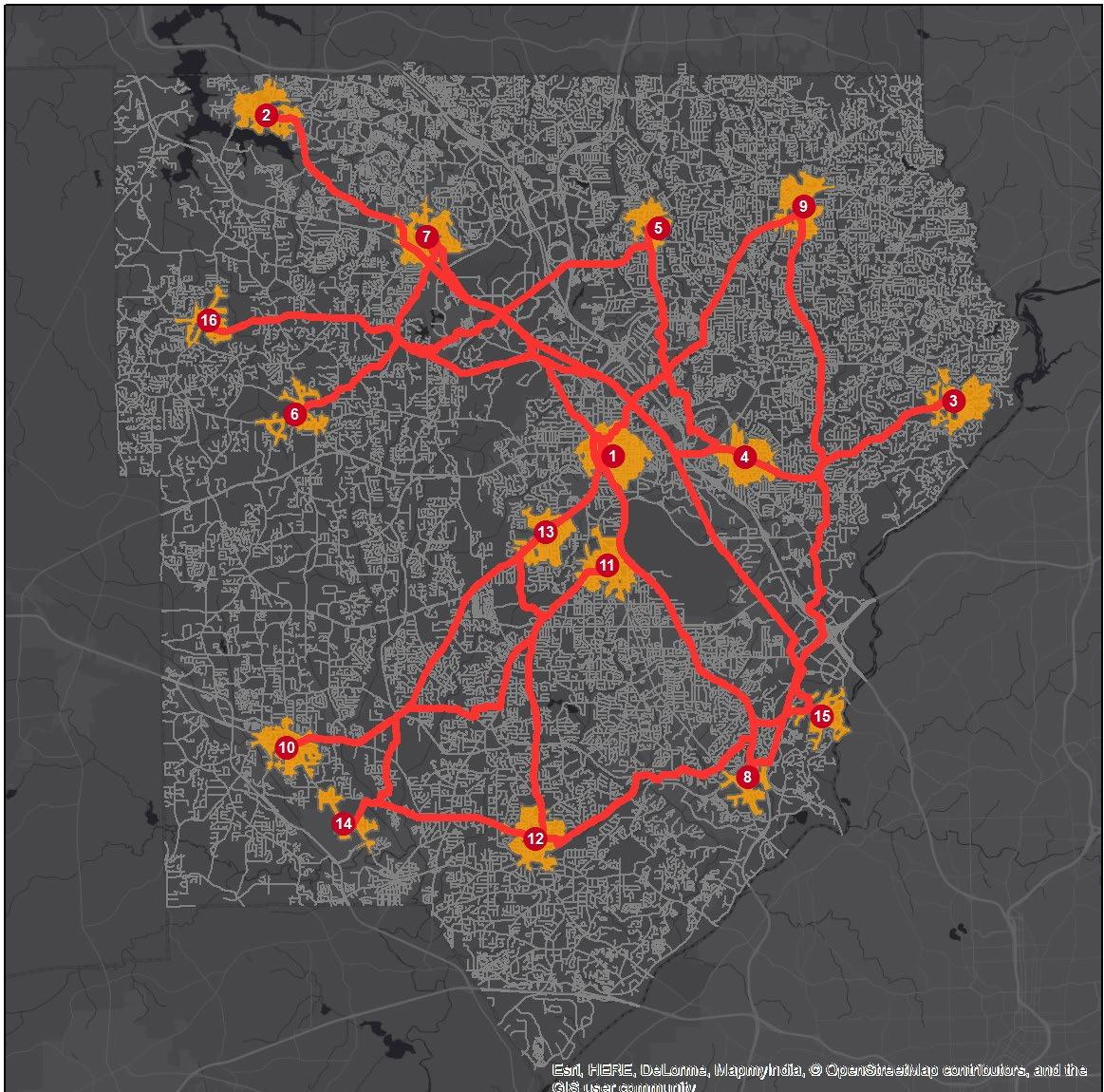
LibraryRoute 1 - in default library order with no optimization
LibraryRoute 2 - order optimize without start and end point

LibraryRoute 3 - library order in total optimization in distance


 LibraryRoute 1 - route with restrictions applied
Service Area - library service area in one mile buffer
Closest Facility - closest library to each schools
LibraryRoute 1 - route with restrictions applied
Service Area - library service area in one mile buffer
Closest Facility - closest library to each schools
Atlanta DRUNKEN MARTA
Overview:
Our idea is to create a public transit network that will serve the premier nightlife and high density residential areas of Atlanta. First, we identified the most popular bars and restaurants within the Atlanta city boundaries according to TripAdvisor suggestions. Then, using ARC population density data and college locations, we mapped residential hotspots where service demand would be high. We used geospatial analysis to create a service buffer of one quarter and one half mile around both origin and destination points. These were overlayed with existing transit routes and used to pinpoint potential stop locations for the proposed routes. Using network analysis functionality in GIS, we determined the optimal routes to safely and efficiently connect bar patrons to popular living destinations, in a way that integrates with existing public transportation options. This resulted in two bus routes, one loop in central Atlanta, and a line servicing north Atlanta and Buckhead residents.


Conceptual diagram:


Methodology:

Restaurant map Map above shows geolocated locations of top 20 Atlanta restaurants. Bar map Residential service area Create road network Bar and Restaurants Residential Existing Transit Service Potential bus stops Network analysis Quarter and half mile buffer Bar and restaurant service area We geocoded the top 20 Atlanta nightlife destinations to locate these stops in a point layer. The popular bars and restaurants that were identified in the previous step using TripAdvisor rakings were then given a service buffer of one quarter and one half mile. This map shows the residential service areas identified by geospatial analysis. Buffers of one quarter mile and one half mile were identified for location of service stops. Residential map This map demarcates residential hot spots based on population density and college locations in Atlanta. These exist primarily in Midtown, Downtown, Buckhead, and Virginia Highlands.
BUS UBER,TAXI GOOD NOT CHEAP
EARTH CRAFT SITE ANALYSIS PACKAGE


Earth Craft Site analysis package of a site for a tax credit senior community development.


TOPOGRAPHY FAYETTEVILLE, GA HEARTHSIDE LAFAYETTE 2000 RiverEdge Parkway, Suite 450 Atlanta, GA 30328 0 SCALE: feet 100 200 300 1" = 100' SLOPE ANALYSIS FAYETTEVILLE, GA HEARTHSIDE LAFAYETTE 2000 RiverEdge Parkway, Suite 450 Atlanta, GA 30328 0 SCALE: feet 100 200 300 1" = 100' AERIAL DESCRIPTION OF LAND USES FAYETTEVILLE, GA HEARTHSIDE LAFAYETTE 2000 RiverEdge Parkway, Suite 450 Atlanta, GA 30328 0 SCALE: feet 1200' 2400' 3600' 1" = 1200' HYDROLOGY FAYETTEVILLE, GA HEARTHSIDE LAFAYETTE 2000 RiverEdge Parkway, Suite 450 Atlanta, GA 30328 0 SCALE: feet 100 200 300 1" = 100'


VIEWSHED ANALYSIS FAYETTEVILLE, GA HEARTHSIDE LAFAYETTE 2000 RiverEdge Parkway, Suite 450 Atlanta, GA 30328 0 SCALE: feet 100 200 300 1" = 100' 2000 RiverEdge Parkway, Suite 450 Atlanta, GA 30328 0 SCALE: feet 100 200 300 1" = 100' M SOILS FAYETTEVILLE, GA HEARTHSIDE LAFAYETTE 0 SCALE: feet 100 200 300 1" = 100' VEGETATION FAYETTEVILLE, GA HEARTHSIDE LAFAYETTE Enter Client Address 0 SCALE: feet 100 200 300 1" = 100'
DILMUNIA ISLAND LAND USE
Managed and modified the masterplan for Dilmunia Island. Also produced Design Control Guidelines for the plots for selling purposes.

DILMUNIA ISLAND - URBAN DESIGN GUIDELINE


Plot Plan

Dilmunia Health Island Development Control Guidelines Plot Guidance Schedule 3 February 2018 Page 12 Maximum building height shallwithcomply the stipulations in the Schedule 2 table MainEntryRoad Figure 5 - Building Envelope Diagram (indicative Example Only) Height of “Jewel Box” Facade Feature shall not exceed the maximum permissible height of podium Length of “Jewel Box” Facade Feature shall not be more than 30% of the total length of the building’s front facade Refer to Schedule 1 for mandatory minimum front setback requirement Refer to Schedule 1 for minimummandatory side setback requirement 45.1 29.3 45.1 38.4 Note on Public Easement: 1. No boundary walls shall be allowed within public easements. Note on Setbacks: 1. The setbacks shown in the Schedule 1 (Plot Layout) diagram represent setbacks for Podium ONLY. These are minimum setbacks and higher setbacks to allow fire turck access around the building are encouraged. 2. In case of Basement construction, the setback for the basement shall be minimum of 2m from all hte plot boundaries. Except when the podium setback is 0m, then the basement setback shall be 0m. 3. The setbacks are inclusive of public easements. Dilmunia Health Island Development Control Guidelines
Layout Schedule 1 All dimensions are in meters Legend Plot Boundary Setback line Parcel Indicative Open Space Adjacent Plots Public Easement Infrastructure Easement 0 5 10 20 HD MIX 16 Plot Area: 1522.3 sqm 20m ROW HD MIX 17 HD MIX 05 HD MIX 06 HD MIX 07 HD MIX 15 1 meter setback HD WELN 01
Schedule 3 February 2018 Page 13 MainEntryRoad Figure 6 - Example of development within Building Envelope. (indicative example only.) Balconies to be located within recommended tower setback line All roof structures shall not exceed maximum permissible building height “Jewel Box” facade feature allowed within Front Setback Zone Residential or Commercial use allowed at podium street frontage Roof garden for podium encouraged. Parking shall not be permitted on podium rooftop Above-ground parking to be covered and/or screened if visible from street
Plot
Plot Guidance
Schedule 2 Low Density Residential Indicative Open Space Vehicular Access Legend Plot Boundary Infrastructure Easement Adjacent Plots Public Easement 0 5 10 20 20m ROW Keyplan HD MIX 16 HD MIX 16 LAND USE MIXED USE PLOT DEFINITION PARCEL AREA 1,522.3 sqm PLOT REQUIREMENTS NET FLOOR AREA RATIO (NET FAR) 2.2 MAXIMUM ALLOWABLE GFA 3,349.1 sqm SITE COVERAGE Max. Podium Footprint 90% of Plot Area Maximum Tower Footprint 60% Max. Basement Footprint DETAIL LAND-USE Wellness and Health, Medical Clinics 100% of Sellable GFA BUILDING HEIGHT Maximum Total building storeys above Ground (including Podium) 7 storeys total Number of Podium Storeys 2 storeys Maximum Overall Building Height (From entry level) +28.9 m PLOT ENTRY LEVEL Entry Level (EL) + m CD HD MIX 16 Height: 7 Storey FAR 2.2 * Note on Entry Level (EL): 1. The Plot Entry Level (EL) is stated as the nearest road centerline elevation and is approximate. Actual conditions to be verified on site by the developer. 2. The developer shall raise the level of the plot to be at least +250 mm higher than the existing plot entry level so as to avoid flooding of the plot. HD MIX 17 HD MIX 05 HD MIX 15 HD MIX 06 HD MIX 07 EL* + m CD
M3M AEORPOLIS- CONCEPT

Play Entertainment Shopping PROPOSED WORKS Live Live Live Live Health F&B F&B Socialize Learn Work Work
DIAGRAM
M3M AEROPOLIS- AERIAL RENDERING

iconic Smart
Largest
City in the National Capital Region
M3M AEORPOLIS-
EYE LEVEL RENDERING

M3M AEROPOLIS- AERIAL RENDERING

ASPEN
MASTERPLAN
CONCEPT
CONCEPT
SCHEMATIC SCHEMATIC

DESIGN DEVELOPMENT
CONSTRUCTION DOCUMENTS
CONSTRUCTION
DESIGN DEVELOPMENT
CONSTRUCTION DOCUMENTS
Aspen Mountain Highway 82
Fork
OF CITY OWNED PROPERTIES 2014 Site Options 2015 2017
Glenwood Springs Roaring
River INVENTORY
2017
STUDY AND ANALYSIS
SITE OPTIONS TO CITY COUNCIL
Galena
Zupancis New
Aspen City Offices Aspen Police Department
CONSTRUCTION SUITABILITY
RECOMMEND
1. Existing Armory
Armory + Galena
building
2. New city offices
Independence
City
Castle
Highway 82
3. Existing + New
Pass
Core Maroon Creek
Creek Red Mountain
MAIN ST
city
Aspen.
CIVIC
- CONTEXT Above map shows the context of city of Aspen and the diagram below shows the planning work flow for the civic office relocation project for the
of
ASPEN CIVIC MASTERPLAN - CURRENT FACILITIES
Galena Plaza (ACRA)
Rio Grande Building
Mill Street Lot and Rio Grande Pl
Mountain Rescue Property
Armory (City Hall)
Wheeler Opera House
Zupancis
Recycle Lot
Electric Puppy Smith
Aspen Parks Department
Streets Department
Ice Garden Ice Rink
Lift 1A Property
Yellow Brick Building
Aspen Rec Center
Aspen Golf and Nordic Center
Truscott
Housing Department
City Hall Annex
Aspen Police Department
Old Power House
Police Department Leased
City Core Sites
Map showing existing city office facilities in Aspen. The offices are currently dispersed, resulting in operational inefficiency, and poor customer service.

PROPERTY OWNED 52% OF TOTAL SQFT PROPERTY LEASED 48% OF TOTAL SQFT
MAINST
Roaring Fork River
Aspen Mountain
ASPEN CIVIC MASTERPLAN - PUBLIC OUTREACH
Design Criteria 1
What level of building sustainability do you see as appropriate?
Design Criteria 2
To implement a responsible building, how far into the future should the relocation solution be planned for?
Average Building International Green Building Code/ City of Aspen Building Code
US Green Building Council’s LEED Gold Rating World Class Model of Sustainable
What architectural character is most appropriate for these facilities?
Traditional Building Style “Aspen” office building Style
Forward-looking architecture style
What level of architectural presence should the building create?
Humble and not calling attention to itself
Infill to existing community buildings
Should public outdoor spaces be included?
Innovative and leading edge style
10 Years 20 Years 30 Years 40 Years
What level of community interaction do you see as appropriate for the Police Facility?
No community gathering space
Limited interactioncommunity to facilitate key services
50 Years
Interior space to facilitate greater police and community interaction
What level of community meeting space do you see as appropriate for the City Service Facility?
Important presence calling attention to a civic place
Significant landmark building appropriate to their function
No community gathering space
Limited use for community gathering (Lobby)
How interested are you in including a leasable space for an affordable restaurant?
Create a high level of public gathering and amenity space
Not at all interestedthese are not compatible uses
Stakeholders Community
Collecting stakeholder and community input was vital in ensuring that the vision for the future facilities was aligned with community values.

Interior community meeting space
Interested enough to consider more information
Very interested - this is important to the community
Only
No public outdoor space
connections Include a small public low key amenity space
ASPEN CIVIC MASTERPLAN - COMMUNITY CONNECTIONS
The recommended development sites created the potential for a connected civic core, improving way finding, visibility of city services and customer service.

CIVIC CAMPUS EXISTING CITY HALL COURTHOUSE COUNTY OFFICES HUNTER ST SPRING ST
GALENA ST
COUNTY LIBRARY RIO GRANDE BUILDING
CITY
Mountain MAIN ST DOWNTOWN
PARK
CITY MARKET
PEDESTRIAN
PROPOSED POLICE STATION
MONARCHST
PITKIN
PROPOSED
OFFICES Aspen
RUBEY
GONDOLA
RIO GRANDE PARK WAGNER PARK
MALL Roaring Fork River
ASPEN MOBILITY LAB -
BIRD’S EYE VIEW SECTION
SIDEWALK PRIVATESETBACK PRIVATESETBACK SIDEWALK BIKEPAINTEDBUFFER PAINTEDBUFFER
Bird’s eye view showing the vision of the road after reducing the automobile lanes and creating activation spaces.

10’ 6’ 1.5’ 11’ 5.5’ 6’ 10’
BIKE STREET
3’-22’ 10’-22’
ACTIVATION STREET ACTIVATION DRIVE
5’-11’
Bird’s eye view showing the types of individual activation spaces.

10’ 6’ 1.5’ 11’ 5.5’ 6’ 10’
PRIVATESETBACK
BIKEPAINTEDBUFFER PAINTEDBUFFER BIKE STREET ACTIVATION STREET ACTIVATION DRIVE 3’-22’ 10’-22’ 5’-11’ DINING MOTORCYCLE PARKING BICYCLE RACK DINING DINING SEATING SEATING SEATING VALET RIDE SHARE PICK UP/DROP OFF
WECYCLE
SIDEWALK PRIVATESETBACK
SIDEWALK
INFORMATION BOOTH