ST LEONARDS AND WAVERLEY NEIGHBOURHOOD PLAN

Draft Structure Plan for Community Consultation

Draft Structure Plan for Community Consultation
This work is copyright. Apart from any use permitted under the Copyright Act 1968, no part may be reproduced by any process without written permission from Mesh Livable Urban Communities Pty Ltd.
Disclaimer
All professional care has been taken to ensure that the content of this report is current and accurate. However, it is not purported that it is complete, and it is not guaranteed that the content of the report is free from errors. Mesh accepts no liability for error, loss, damages or other consequences arising from reliance on information contained in this report.
Client City of Launceston
Project St Leonards and Waverley Neighbourhood Plan
Version 01 Prepared By Mesh
Reviewed By Mesh
Date 19 March 2025
We acknowledge Tasmanian Aboriginal People as traditional custodians of this land. We pay respect to Elders past and present. We acknowledge and honour the profound histories, knowledge, and lived experiences of the Tasmanian Aboriginal People, who are the First People of this land and uphold the world’s oldest continuing land use planning and management system.
We deeply respect their lasting connection to Country and the profound importance they place on shelter, community, and belonging.
TERM DEFINITION
City of Launceston Council
Neighbourhood Plan
St Leonards and Waverley Neighbourhood Plan
Background Report St Leonards and Waverley Neighbourhood Plan Background Report 2025
Bi-di Bi-directional bicycle lanes
Turn up and go Turn up and go bus services
TERM DEFINITION
NTRLUS Northern Tasmanian Regional Land Use Strategy
GLP
Greater Launceston Plan
IFF Infrastructure Funding Framework
SAP Specific Area Plan
NTC
Neighbourhood or Town Centres
WIK Works In Kind
LUPA Land Use Planning Approvals Act 1993
TPS Tasmanian Planning Scheme
TPP Tasmanian Planning Policies
SPP State Planning Provisions
LPP Local Planning Provisions
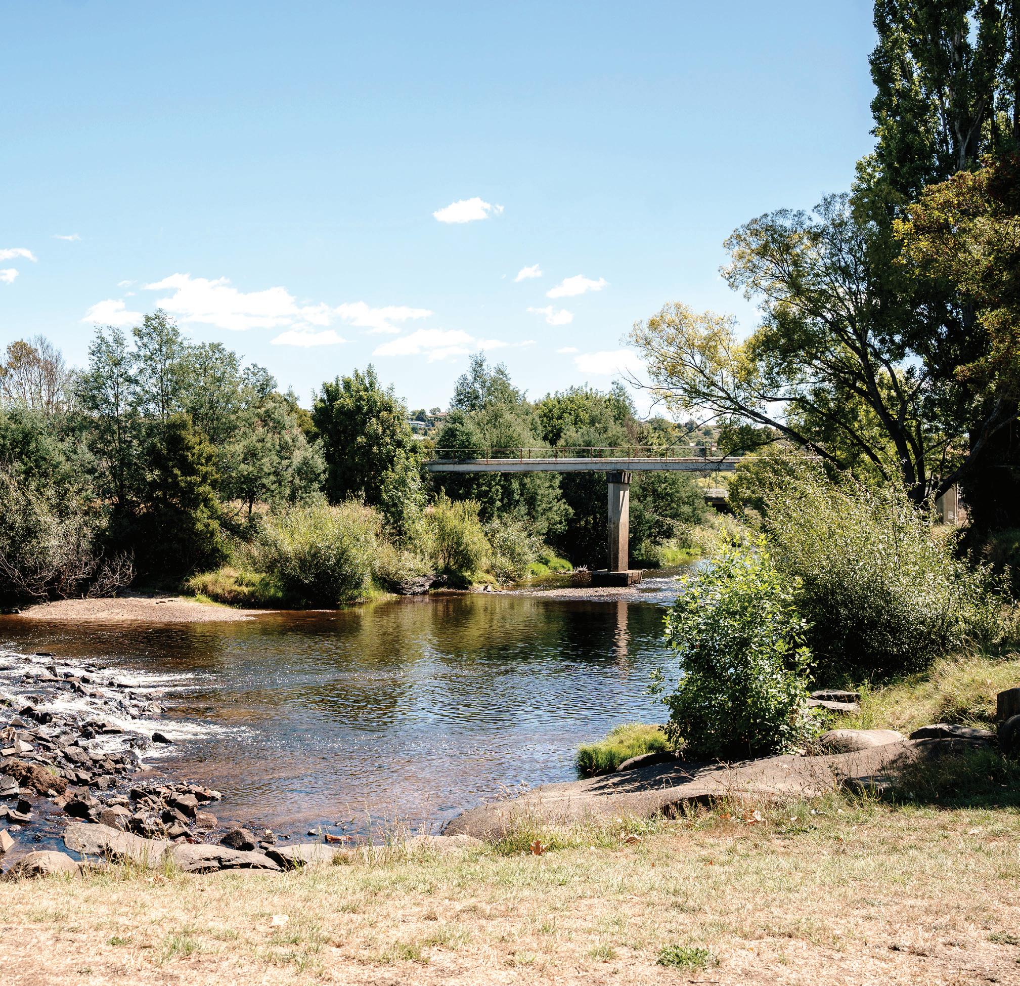
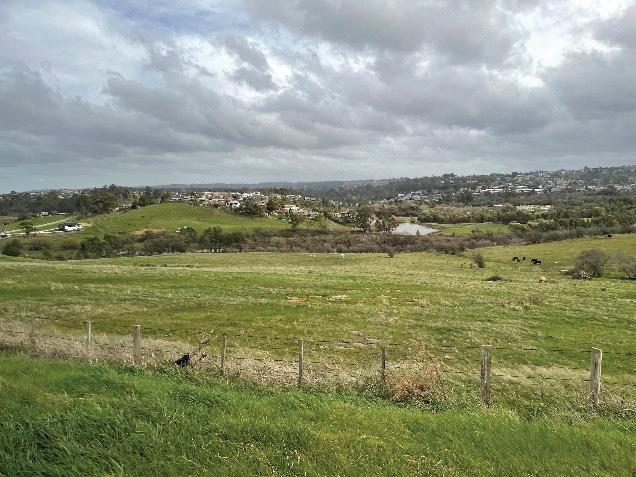
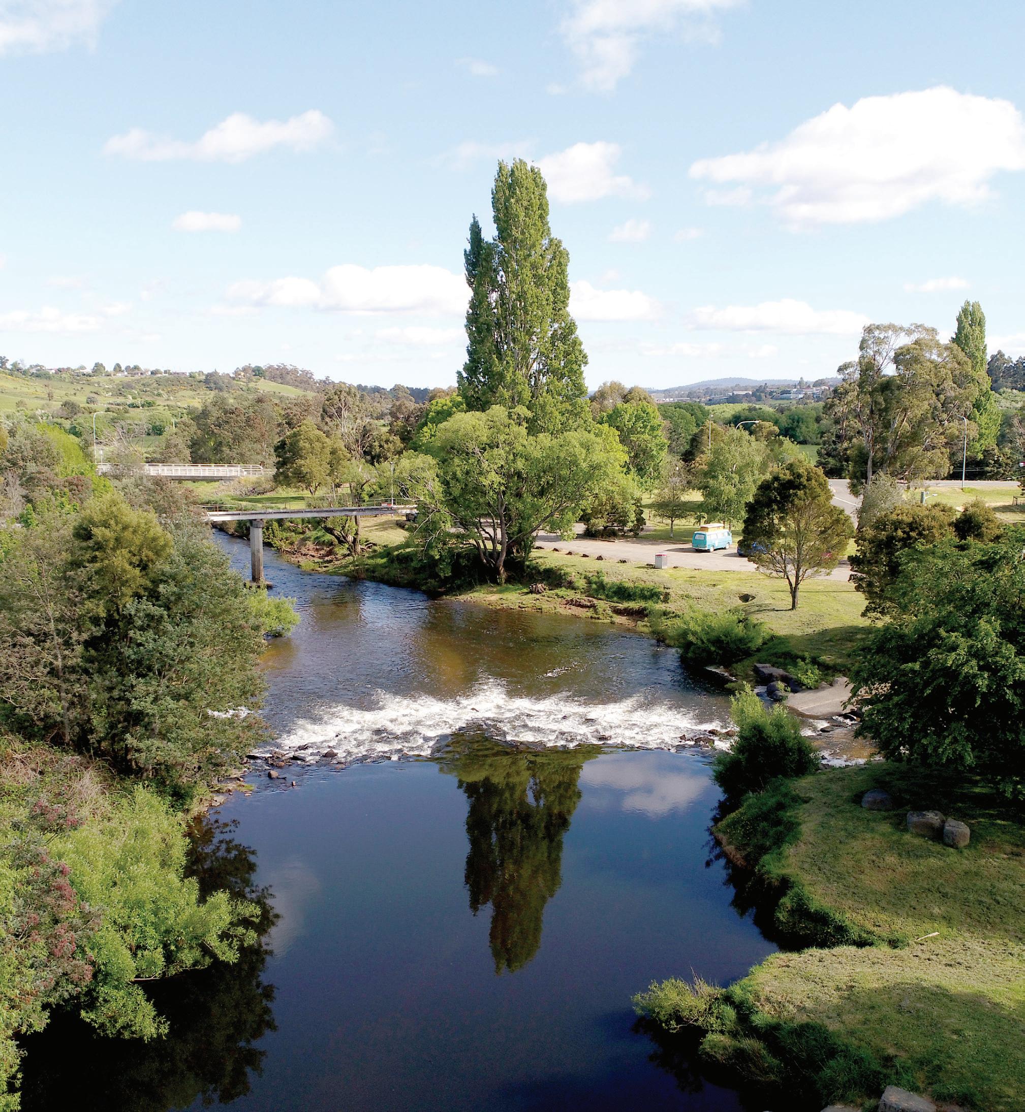
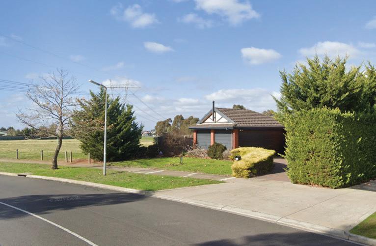
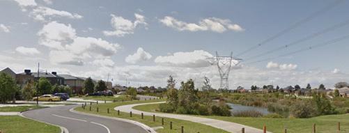
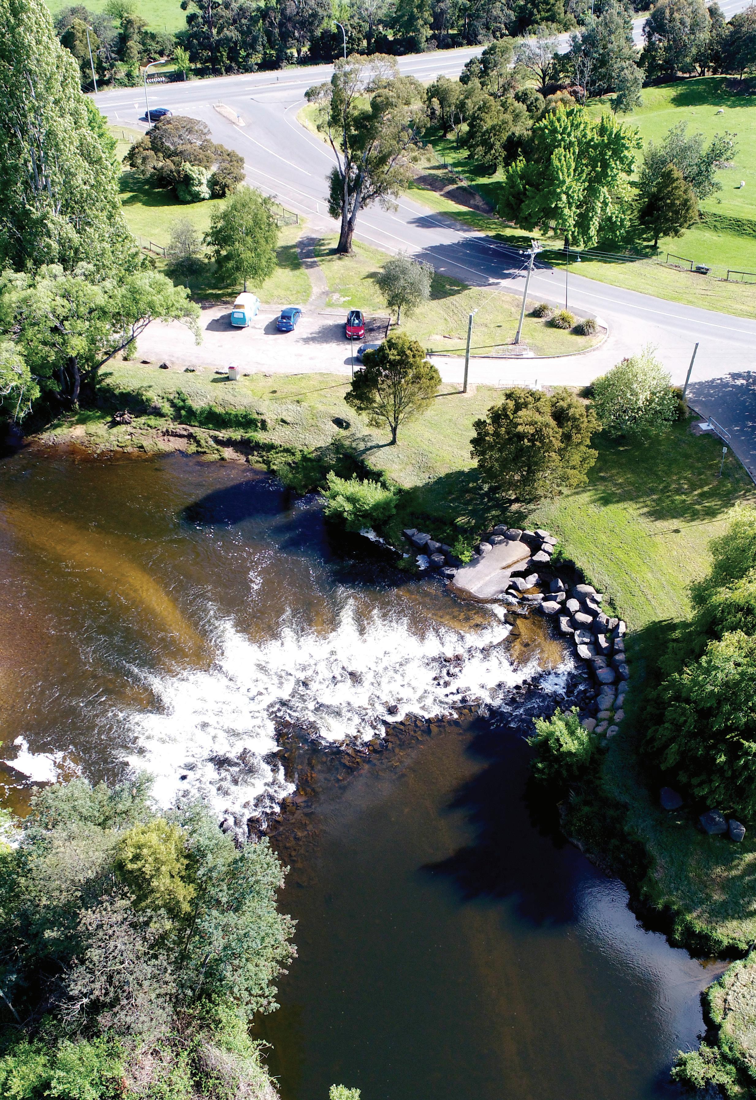
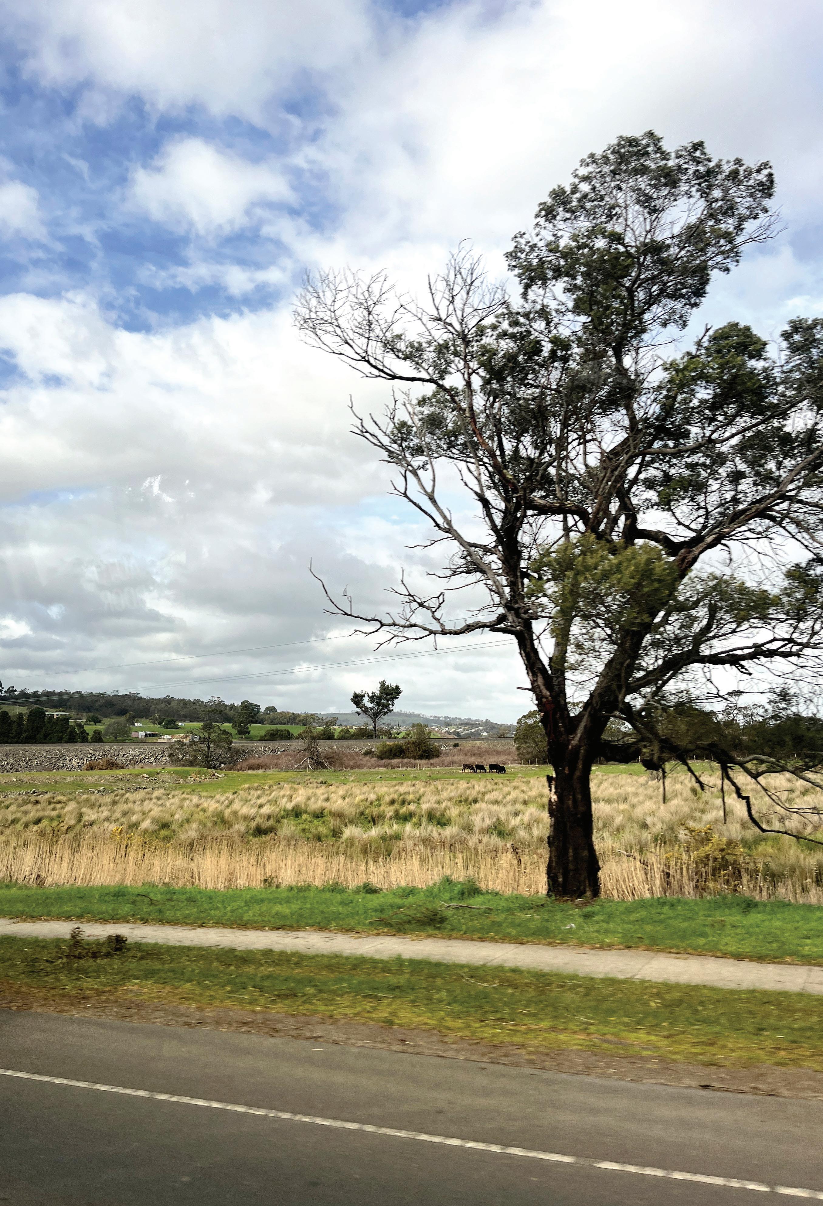
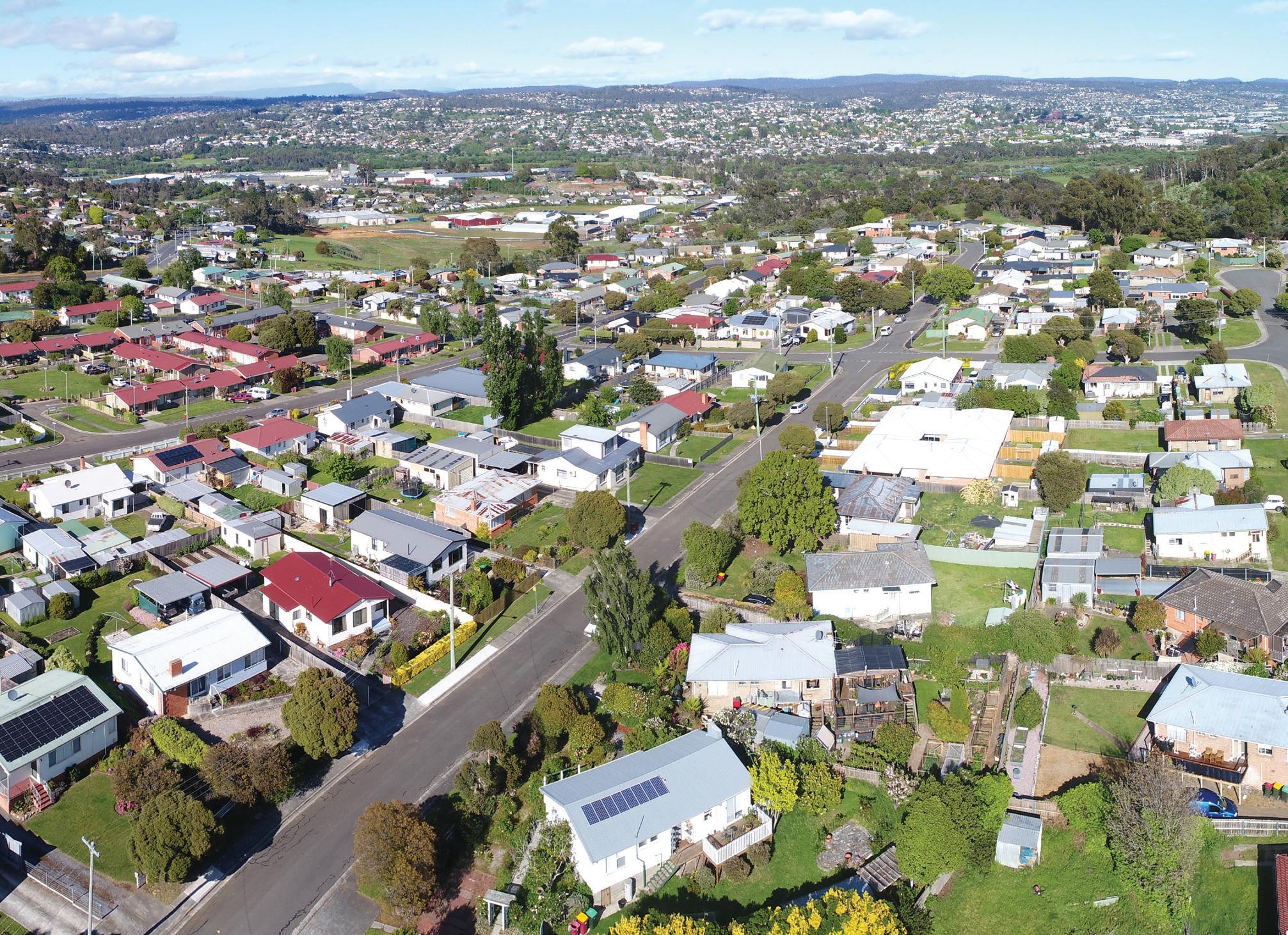
St Leonards and Waverley are established suburbs with proximity to central Launceston. Housing in the area is generally predominantly stand alone housing with some areas including lower density rural lifestyle properties. St Leonards and Wavlerley provide employment through light industrial uses along St Leonards Road aswell as community facilities such as schools and the St Leonards Recreation Reserve. The area is characterised by striking view lines towards nearby mountain ranges and the North Esk River, Launceston and Ben Lomond. The area also includes key waterways such as the North Esk River and Distillery Creek. Community has remarked that the area has a semi-rural feel due to its interface with natural areas and proximity to farm land.
The St Leonards and Waverley growth area is identified in the Northern Tasmanian Land Use Strategy (NTRLUS) as a priority investigation area for new housing. In recent years, a number of larger land parcels have been rezoned for urban development with recent subdivisions delivered. To date, these subdivisions have occurred in a relatively ad-hoc nature which has placed pressure on existing services and infrastructure and threatened the ability to protect the area’s valued character.
The City of Launceston (Council) identified the need for clear strategic planning for the St Leonards and Waverley growth area to ensure new housing is delivered in a coordinated and sustainable way. This document – The St Leonards and Waverley Neighbourhood Plan – has been prepared to provide this guidance and set a framework for St Leonards and Waverley’s future.
The Neighbourhood Plan is structured in six parts.
1. Introduction and Context
Overview of the area, regional context, and purpose of the Neighbourhood Plan.
2. Neighbourhood Plan Purpose
Outlines the role of the Neighbourhood Plan and why it has been prepared.
3. Preparing the Neighbourhood Plan
Outlines the inputs and steps that informed the Neighbourhood Plan, including how the community has informed the plans directions.
4. The Neighbourhood Plan for St Leonards and Waverley
Sets the long-term vision for St Leonards and Waverley including the Strategic Directions for the corridor, and strategies and actions for how change will occur.
5. Implementation
Outlines proposed zoning and actions for further strategic work, as well as an approach to staging development and infrastructure funding and delivery.
6. Monitoring + Review
Sets out how the Neighbourhood Plan will be reviewed and updated over time to ensure its content remains relevant and accurate.
Part 4 of the document, includes a vision and three strategic directions that will shape how St Leonards and Waverley will grow and change over time.
The Vision for St Leonards and Waverley is:
“ The St Leonards and Waverley growth area is a dynamic community balancing new homes with its existing semi-rural surrounds. It safeguards the environment, including waterways, landforms, and vegetation, while honouring the area’s history.
Building homes here focuses on accessibility, sustainability, and community through integrated transport, open spaces, and local amenities. This is where people come to live, work, and thrive in an inclusive and vibrant community”.
The three Strategic Directions of the Neighbourhood Plan help to achieve the Vision:
Each strategic direction includes a series of strategies and actions, which will be implemented to ultimately deliver the vision.
The Implementation chapter of the document is critical to ensure the Neighbourhood Plans aspirations are realised. Putting a Neighbourhood Plan into action involves a range of different implementation steps including statutory implementation (such as rezoning land), infrastructure funding and delivery and general actions (like advocacy and further work).
The last chapter is Monitoring and Review to ensure the Neighbourhood Plan remains relevant and completion of actions remain on track. This section identifies the need to periodically re-engage with the community to ensure the Neighbourhood Plan’s aspirations remain relevant and aligned with community needs.
The St Leonards and Waverley Neighbourhood Plan (the Neighbourhood Plan) guides future growth in Greater Launceston.
The Greater Launceston Plan 2014 (GLP) and the Northern Tasmanian Regional Land Use Strategy 2021 (NTRLUS) recognise St Leonards and Waverley as growth areas, emphasising the need for strategic planning.
The Tasmanian State Government requires structure plans to address a 15-year land supply. This Neighbourhood Plan will guide growth over the next 30 years, including staged land release.
An Infrastructure Funding Framework (IFF) will be integrated into the Neighbourhood Plan to ensure infrastructure supports this growth.
St Leonards and Waverley are located on the eastern edge of Launceston, approximately 5 kilometres from the Central Business District (Figure 1). Located in the Tamar Valley, these suburbs offer a semi-rural character with easy access to Launceston’s city centre. St Leonards and Waverley connect to nearby agricultural land and natural landscapes, supporting sustainable growth and development consistent with Launceston’s function as the major regional city in northern Tasmania.

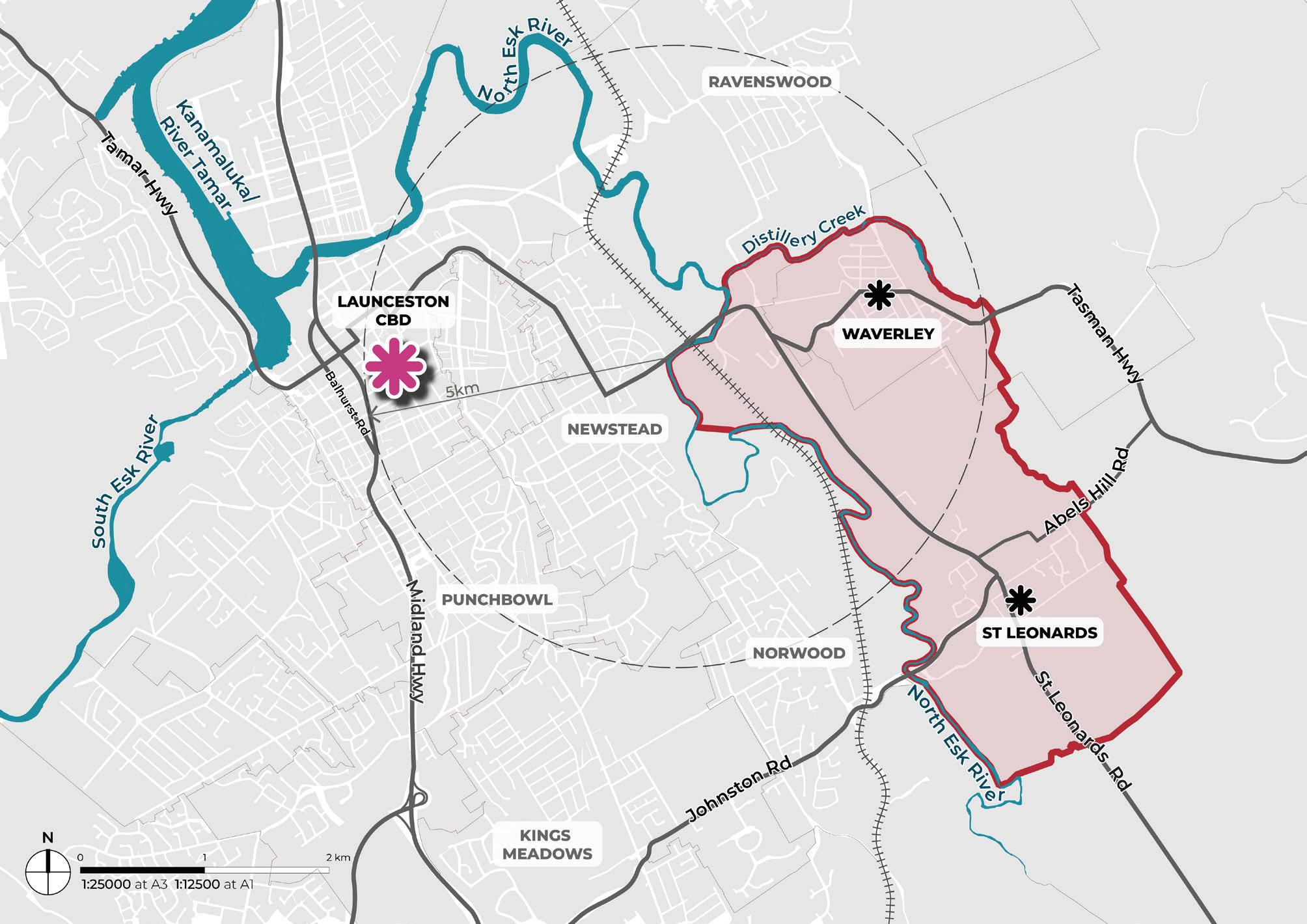
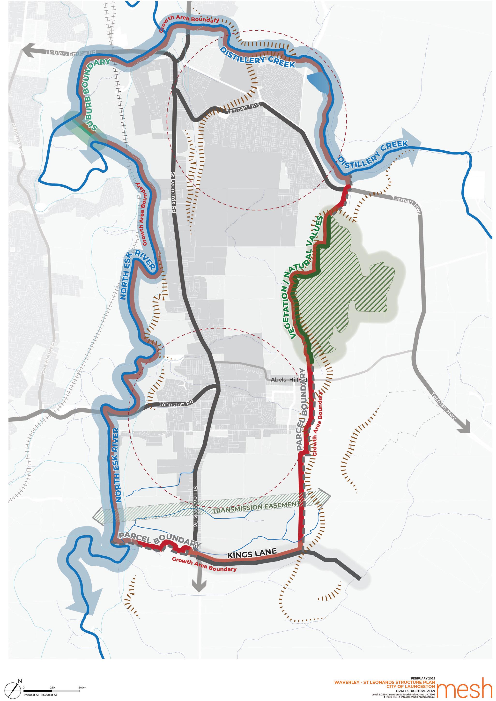
The growth area boundary of the Neighbourhood Plan (Figure 2) includes both the suburbs of St Leonards and Waverley. The NTRLUS broadly designates St Leonards and Waverley as a growth corridor and future investigation area for residential development and recommends the boundary for growth be defined through a structure planning process.
The boundary is informed by the existing zoned land, current residential land uptake, land use constraints, logical barriers to development and physical features including topography, waterways and vegetation.
A broader study area was adopted in the site analysis that informed this growth area boundary, as illustrated in the St Leonards and Waverley Neighbourhood Plan Background Report 2025 (Background Report).

A Neighbourhood Plan, which can also be called a Structure Plan, is a guide for how a local area should evolve and develop over time. Having a forward focus, a Neighbourhood Plan sets a framework for how future development will be coordinated with the delivery of roads, open space, shops and community services. A Neighbourhood Plan includes a vision, strategies and actions for further work, including implementation responsibilities.
A Neighbourhood Plan can incorporate a funding framework, in this case an Infrastructure Funding Framework (IFF). An IFF sets out how infrastructure such as roads, intersections, recreation facilities and other community infrastructure will be funded and delivered. The purpose of the IFF is to outline infrastructure projects required to support development and outline who is responsible for their delivery.
St Leonards and Waverley are identified in the GLP and the NTRLUS as locations to support additional housing. The Neighbourhood Plan and IFF provide local-level guidance on how this growth occurs in a coordinated and sustainable way.
The Neighbourhood Plan provides local guidance in response to state and regional policy direction (Figure 3). The Neighbourhood Plan will be implemented through the Launceston Local Provisions Schedule of the Tasmanian Planning Scheme, ensuring its plans and directions are considered in development application assessments. Implementation will take the form of changes to zones, overlays, and preparation of Specific Area Plans (SAPs) or Particular Purpose Zones. The implementation of the Neighbourhood Plan will be staged through planning scheme amendments, guided by Council direction or driven by developer-led initiatives.
Other actions in the Neighbourhood Plan include further strategic work such as master planning or advocacy (for example, to advocate for improved bus services). These actions will be led by Council or other stakeholders to support the plan’s vision.
Schedule 1 Objectives
Land Use Planning Approvals Act 1993 (LUPA)
Tasmanian Planning Policies (TPPs)
Northern Tasmanian Regional Land Use Strategies (NTRLUS) (under review)
Municipal Plan Corporate Strategic Plan
Launceston Housing Plan & Action Plan 2025 - 2040
Local Strategic Plan
St Leonards and Waverly Neighbourhood Plan
Statutory Implementation
Tasmanian Planning Scheme
State Planning Provisions (SPP)
Local Provisions Schedule (LPS)
State PoliciesState Policies and Projects Act 1993
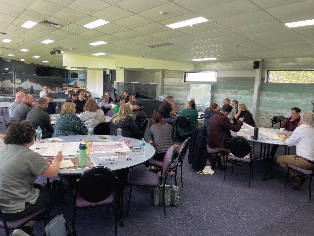
The Neighbourhood Plan was developed through a collaborative process, including workshops with council staff, consideration of technical inputs, review of existing background documents, and comprehensive community and stakeholder engagement (Figure 4).
Background investigations included:
• A review of existing strategic and technical documents.
• An understanding of existing planning scheme guidance.
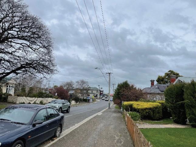
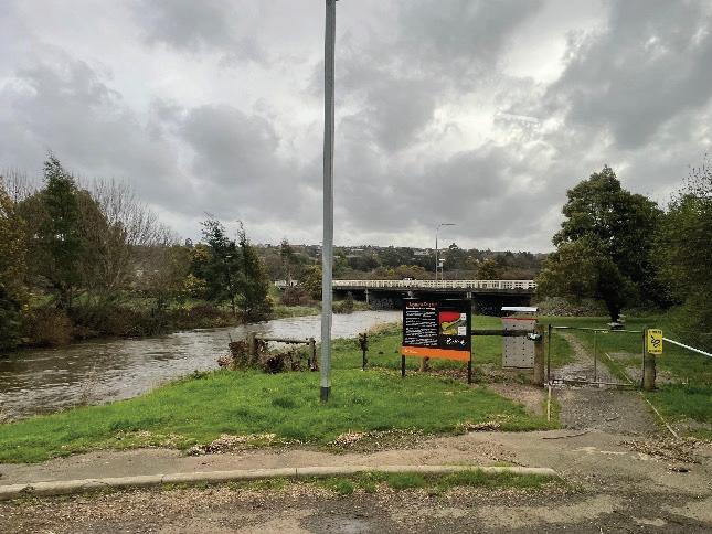
• A site visit to key locations across St Leonards and Waverley.
• A review of approved and draft subdivision plans prepared by land owners.
• Preparation of a series of site analysis maps, including topography, natural features, existing infrastructure, and other relevant site attributes.
The Background Report provides a detailed overview of the information considered at this stage.
During the visioning phase, a preliminary plan was developed and shaped by insights from a workshop attended by council staff and key technical consultants specialising in community engagement, drainage, transport, natural values, bushfire management, agricultural capability, historic heritage, and cultural heritage. These experts have provided detailed reports that have informed the Neighbourhood Plan (Table 1).
During the visioning phase and throughout the project, targeted engagement also occurred with State Government stakeholders including TasWater, TasNetworks, Department for Education, Children and Young People, Department of State Growth and Department of Health.
Major land owners were consulted during this phase. The first round of community engagement, detailed in the next section, also informed the preliminary plan.
An integrated transport assessment that provides strategies, and concept designs for managing mobility and connectivity across the study area, including transport infrastructure requirements and upgrades aligned with planning objectives and municipal standards.
An assessment of historic heritage that identifies significant sites and provides recommendations to preserve and integrate these historic values into the Neighbourhood Plan, ensuring alignment with heritage planning objectives.
A natural values assessment that identifies flora and fauna values and provides strategies for their protection and enhancement to ensure alignment with environmental objectives.
Technical insights, concept designs and recommendations for managing stormwater across the study area, including drainage catchments, water quality and infrastructure upgrades.
An assessment of retail and community needs that provides insights and strategies for prioritising land uses and community infrastructure, including open space, to support sustainable residential growth.
An Aboriginal heritage assessment that identifies culturally significant sites and provides strategies for their protection and integration, aligning with relevant legislation.
A land capability assessment that evaluates the study area’s suitability for agricultural land using a land classification system to guide sustainable land management and development practices, consistent with State policy guidance.
A bushfire advice report that identifies bushfire hazard risks and protection measures for the study area to ensure compliance with bushfire management standards.
Community and stakeholder engagement advice that provides critical insights and feedback, shaping the Neighbourhood Plan to reflect local needs and priorities while aligning with broader planning objectives.
TABLE 1. NEIGHBOURHOOD PLAN TECHNICAL INPUTS
The Neighbourhood Plan is informed by two engagement stages; stage 1 a reintroduction of the project to the community, and stage 2 seeking feedback on the Draft Neighbourhood Plan.
1 Reintroduce (7 November 2024 to 6 December 2024)
Purpose: To re-introduce the project following previous engagement in 2018, including re-introduction of the project purpose and understanding whether previous feedback is still relevant.
Approach: Distribution of posters and flyers, social media posts, creation of a project webpage on City of Launceston’s ‘Tomorrow Together’ site, and release of a survey. The survey asked questions like what facilities would you like to see in the area, how do you live and travel and what are your priorities for the future.
418
Survey Responses
854 Visits to the project homepage
A total of 418 survey responses were collected, providing a comprehensive representation of residents from St Leonards and Waverley as follows:
72% of respondents were female 47% are couples with children
39% are aged between 35-49
89% live in St Leonards or Waverley DEMOGRAPHIC SNAPSHOT OF SURVEY RESPONDENTS
Stage 2 Engage (29 March 2025 to 29 April 2025)
Purpose: To seek feedback on the contents and direction of the Draft Neighbourhood Plan.
Approach: This engagement will include pop up events where people can learn more about the Neighbourhood Plan, a workshop as well as online engagement via a survey.
The community’s key priorities from the analysis of survey results from the Stage 1 Engagement are summarised below.
Transport and movement
• Additional walking paths, cycle ways and bushwalking connections.
• Safe, connected and accessible footpath network.
• Frequent and reliable bus services connecting the area to service centres such as Kings Meadows and the Launceston CBD.
• Enhanced road safety and better management of congestion and speeding.
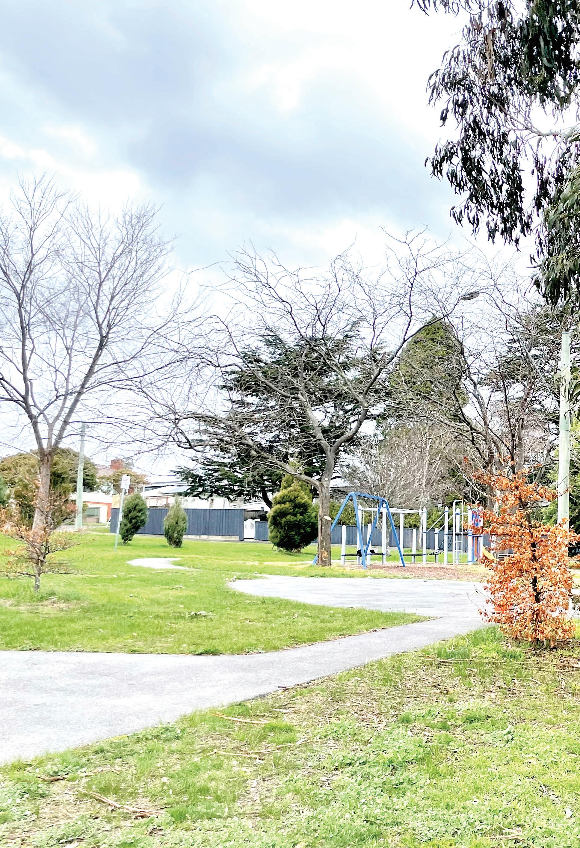
Open space and recreation
• Improved playground equipment and family-friendly open spaces.
• New amenities in local parks such as BBQs, public toilets and lighting.
• Improved off-leash, fenced dog parks.
Social infrastructure
• Community facilities suited to host events and gatherings.
• Local health services, particularly general practitioners and a pharmacy.
• Additional childcare services, improved schools and the addition of a high school.
Retail and commercial services
• More shops and retail services such as supermarkets and service stations.
• Local cafes and food businesses.
• Small businesses such as a butcher, florist or convenience store.
Residential development
• Mixed views on residential growth.
• Acknowledgement that growth will result in additional facilities and services.
• Concern around density and the loss of the existing ‘village feel’.
Community perceptions and safety
• Desire for increased police presence to address anti-social behaviour.
• Negative sentiment regarding social and community housing.
• Stigma associated with the socio-economic profile of the area, particularly Waverley.
The Background Review, Visioning and Phase 1 Community Engagement informed the development of key planning and urban design considerations for the growth area, which are detailed within the Background Report and summarised in Figure 5. These key considerations were categorised into three broad themes that have formed the Strategic Directions that helped shape the Vision of the Neighbourhood Plan.
The Strategic Directions are:
SITE FEATURES

MOVEMENT NETWORK
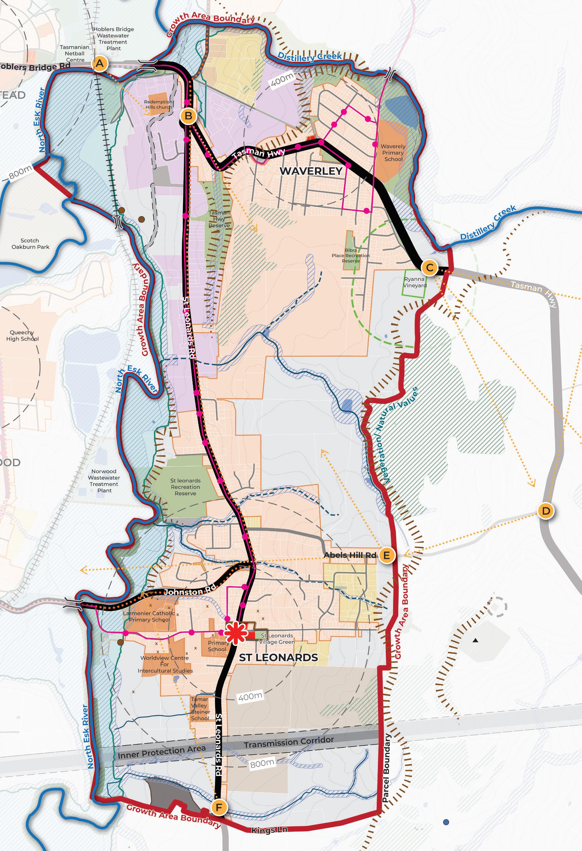
Growth Area Boundary is informed by waterways (North Esk and Distillery Creek), areas of natural value, property boundaries, topography and road access.
PUBLIC AND ACTIVE TRANSPORT

TOPOGRAPHY / VIEW LINES

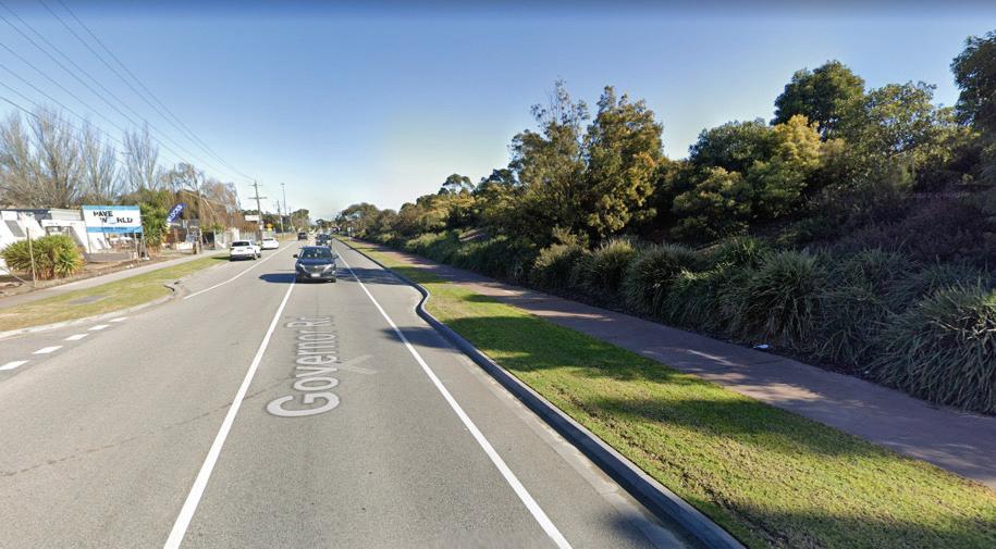
Existing area of traffic congestion during peak times (Hoblers Bridge Road and Johnston Road).
Limited opportunity for new intersections from St Leonards Road and Tasman Highway into the growth area.
St Leonards Road is the primary north-south arterial servicing the growth area.
The Tasman Highway cuts through the northern section of the growth area, servicing existing developed areas.
Bus routes are limited to the existing Waverley residential areas and St Leonards Road.
Designated Cycling Routes are limited to St Leonards Road and Johnston Road.
Walking paths through the growth area are often narrow and obstructed in some instances.
Recreational trails are mainly located on the edges of the growth area.
Areas where slope is greater than 20% limit the type, extent and viability of residential development.
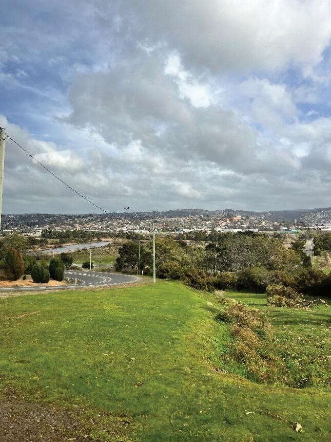
Key view lines from road entrances into the growth area are from the north along Hoblers Bridge Road (A), entrance to St Leonards Road to the Tasman Highway Reserve (B), along Tasman Highway looking east (C), looking north (D) and west (E) from Abels Hill Road and looking north from the southern end of the growth area (E).
LAND USES

LAND USE BUFFERS
NATURAL VALUES

ACTIVITY CENTRES

HERITAGE
Pockets of rural zoned land located between existing residential areas form land use “gaps”.
Isolated corridor of light industrial along St Leonards Road.
Currently no clear open space hierarchy, making it difficult to identify gaps within the network.
Electricity transmission corridor provides an enduring boundary to development to the south.
Vineyard and associated buffer to be protected.
Natural values to be retained and enhanced through exclusion from growth area boundary and identification of open spaces and development outcomes.
Future development to respond to bushfire hazard areas.
Limited retail provision, the main activity centre is the St Leonards village with a small number of shops in Waverley.
Gap in the offering and distribution of community facilities and opportunity to co-locate complimentary land uses (i.e. co-locate schools with community facilities).
Existing primary schools in St Leonards presents an opportunity to contribute to the vibrancy of the St Leonards village centre.
Heritage sites within the growth area not adequately captured in planning policy. A number of heritages sites around St Leonards Village are concentrated contributing to an overarching character.
Existing Aboriginal heritage sites are located along North Esk River. A new Aboriginal Heritage site was identified outside of the growth area boundary.
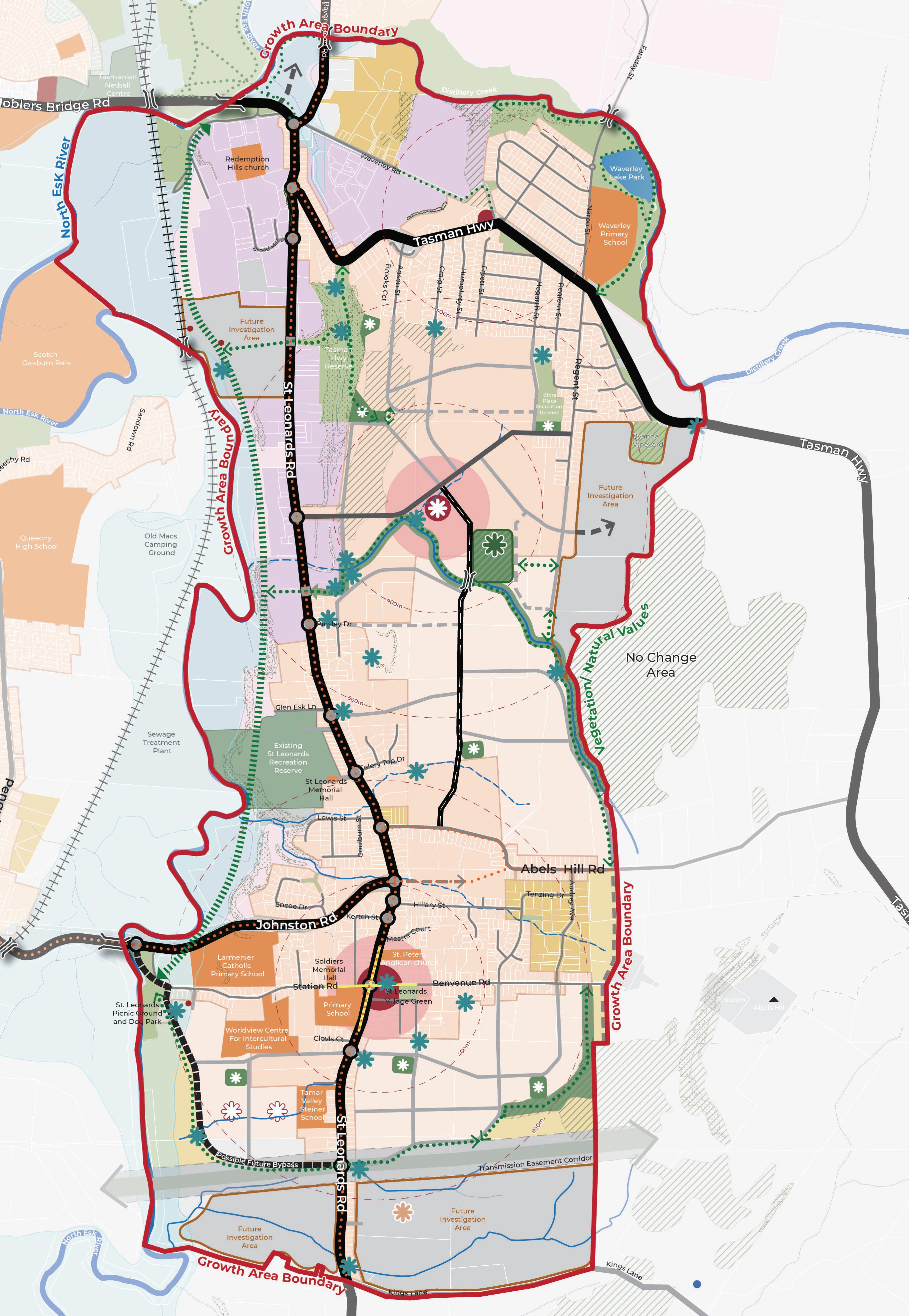
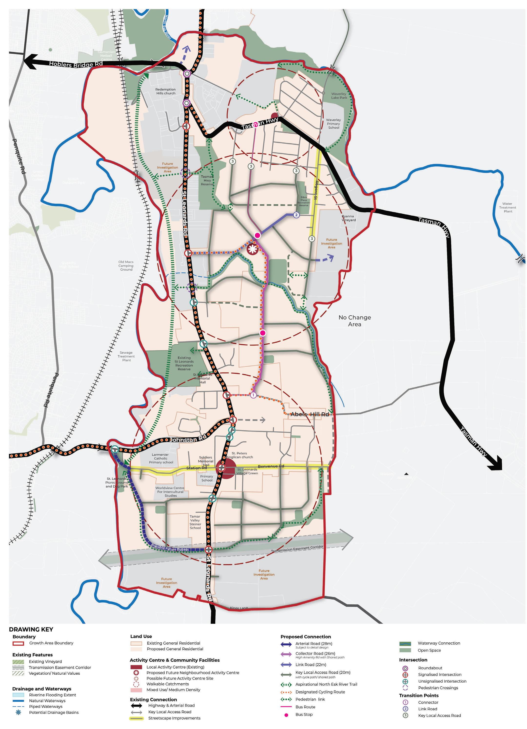
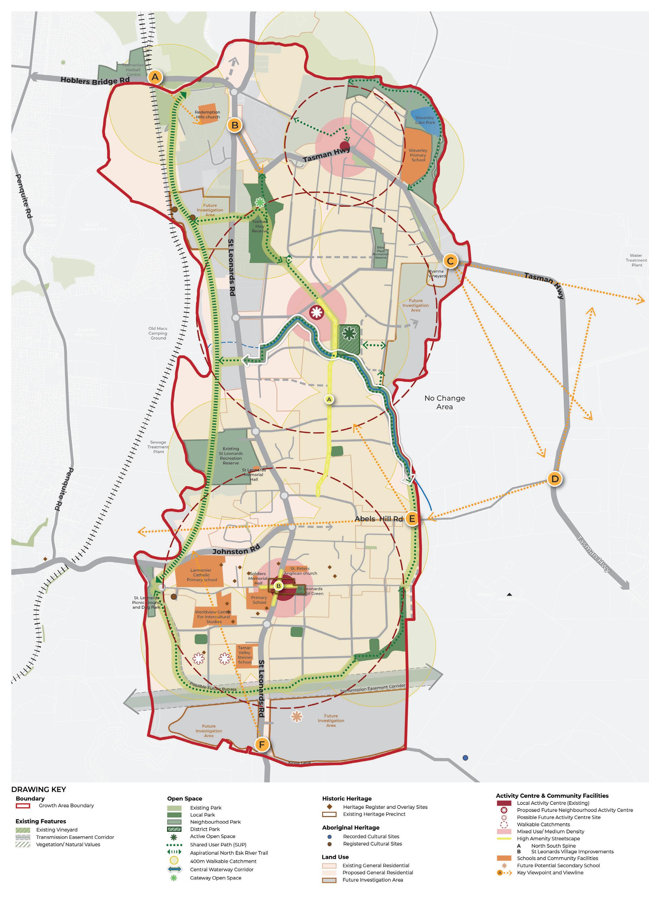
The Neighbourhood Plan for St Leonards and Waverley outlines the planning and design goals for future growth (Figure 7). It highlights strategic land use directions, including the growth area boundary, land uses, activity centres, open spaces, movement network, natural features, and future investigation areas.
Delivery of the Neighbourhood Plan is supported by a Vision, Strategic Directions, Strategies and Actions (Figure 6).
The Vision describes the future desired land use and design outcomes for St Leonards and Waverley. It defines WHAT we are trying to achieve.
The Neighbourhood Plan (Figure 7) identifies WHERE change is located.
The Strategic Directions describe the WAYS the Neighbourhood Plan will achieve the vision under the following themes:
The Strategies outline HOW the Strategic Directions will be achieved.
The Actions identify the FURTHER WORK required to achieve the Strategies.
Actions are split into Council and Agency Actions, led by the City of Launceston with some actions occurring in partnership with Government agencies. Proponent Actions are led by developers or key stakeholders.
Actions include Catalyst Projects, which are projects identified as important in kickstarting the Strategic Directions. The Council will begin implementing the Neighbourhood Plan with these immediate actions
“ The St Leonards and Waverley growth area is a dynamic community balancing new homes with its existing semi-rural surrounds. It safeguards the environment, including waterways, landforms, and vegetation, while honouring the area’s history.
Building homes here focuses on accessibility, sustainability, and community through integrated transport, open spaces, and local amenities. This is where people come to live, work, and thrive in an inclusive and vibrant community”.
The Strategic Directions implement the Vision for St Leonards and Waverley. The Strategic Directions have been informed by the background work discussed previously in the document, policy direction and technical guidance.
The NTRLUS is the state government policy document that provides the strategic basis for decisions related to growth and development for the North of Tasmania. The Strategic Directions implement the directions from the NTRLUS as identified on the following page.
The Neighbourhood Plan sets a Strategic Direction for Sustainable Growth which builds on the NTRLUS strategic direction
G2.1 sustainable urban settlement patterns. This is achieved through definition of a growth area boundary that responds to context and land use constraints. Housing density responds to technical information (such as flooding and natural values as per NTRLUS strategic direction G3.1), with denser housing proposed close to amenities.
CATALYST PROJECT 1
Rezone the northern new development area (referred to as Planning Implementation Precinct 1 in the Implementation section) and prepare a Specific Area Plan to unlock new housing and amenities.
The Neighbourhood Plan sets a Strategic Direction for Connected Communities to achieve integration of infrastructure delivery with land use planning, consistent with NTRLUS strategic direction G1.2. Safe, inclusive, and sustainable connections are proposed to support all forms of transport, for enhanced walkability and convenient access to community amenities including open space and activity hubs (consistent with delivering an inclusive community as per NTRLUS strategic direction G2.4).
CATALYST PROJECT 2
Prepare streetscape masterplans for the constructed sections of Station Road / Benvenue Road and Regent Street which identify opportunities for footpath widening, street furniture and tree planting opportunities consistent with the aspirations of the City of Launceston Urban Greening Strategy 2023 – 2040.
The Neighbourhood Plan sets a Strategic Direction for Vibrant Places which builds on the NTRLUS strategic direction G2.3 (promotion of local character values) by protecting view lines, natural values, cultural and historic heritage. The Neighbourhood Plan emphasises responsive design, integration of green infrastructure, and creation of vibrant hubs that support community interaction, amenity, and liveability.
CATALYST PROJECT 3
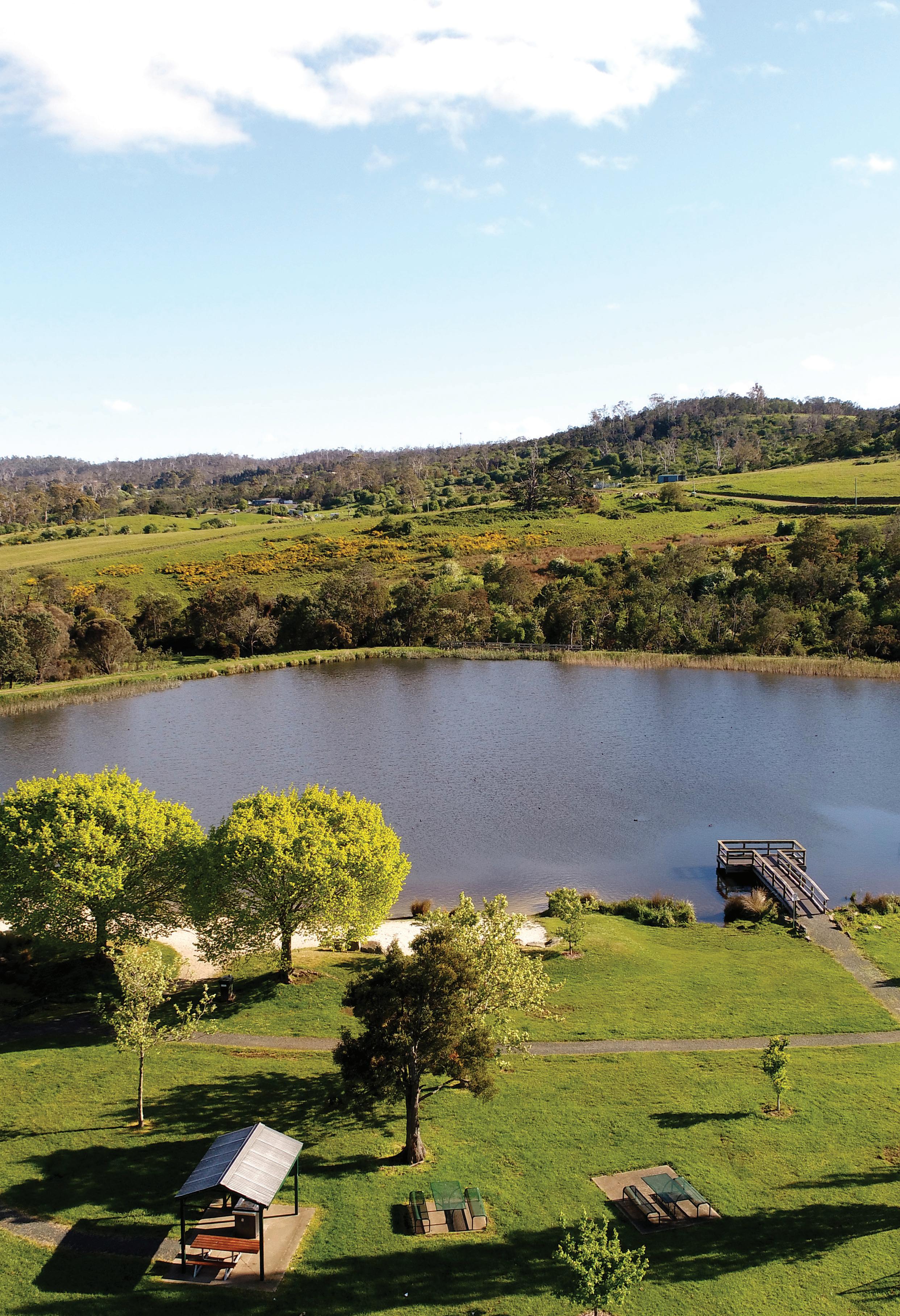
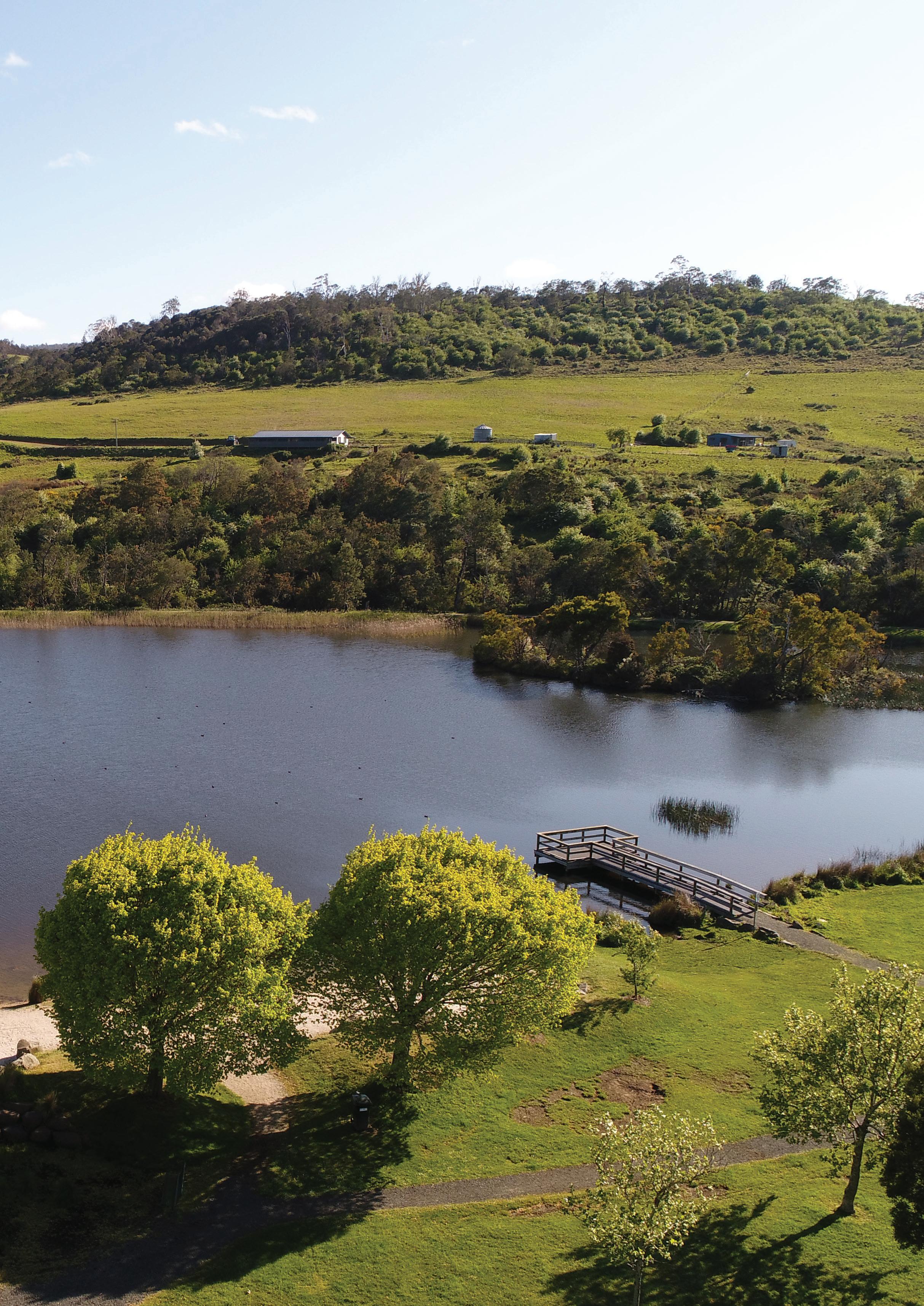
Prepare a landscape masterplan for the Waverley Lake Park that identifies opportunities for improved shared path connections, consistent with the Draft City of Launceston Recreation and Open Space Strategy.
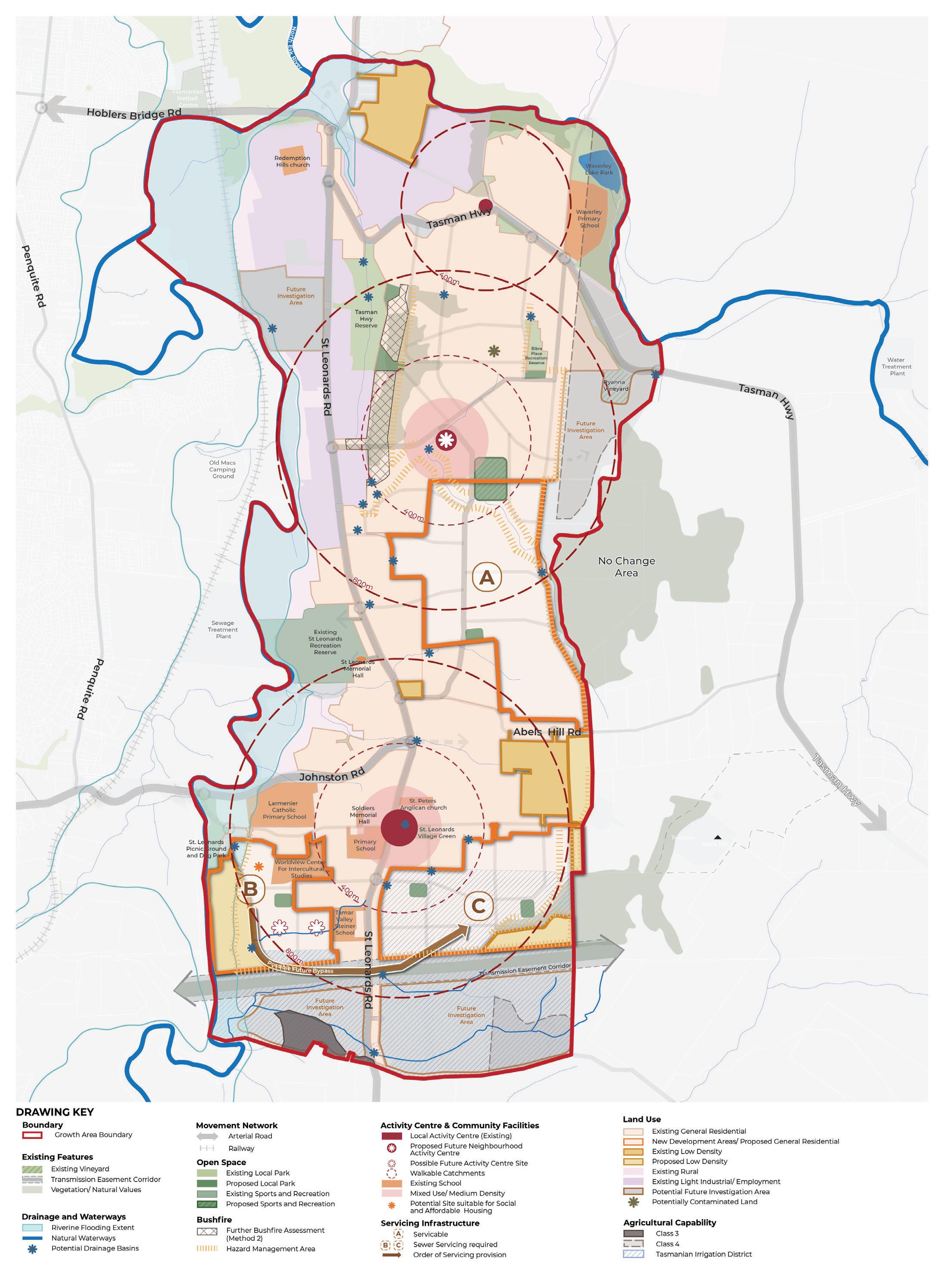


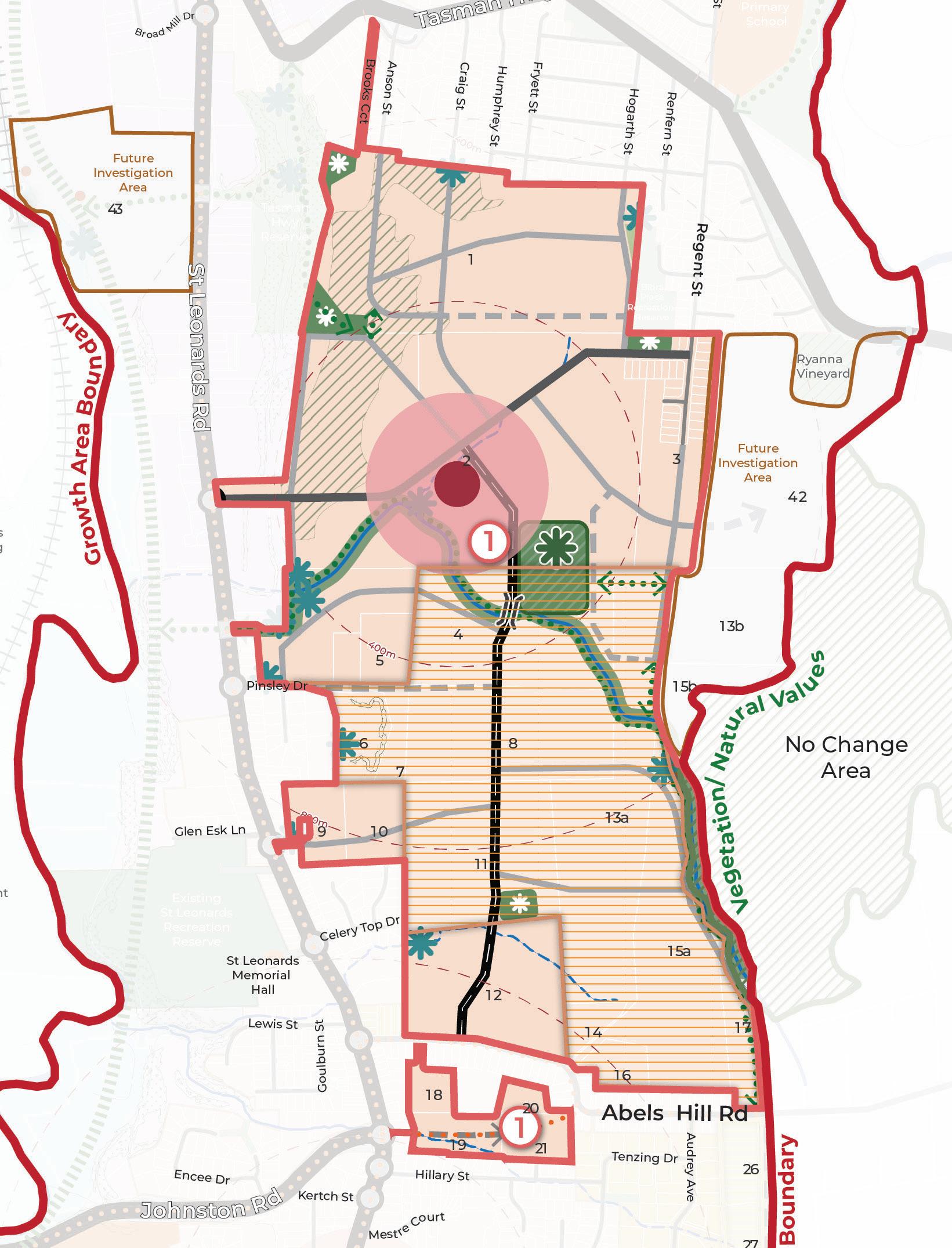
Implement the growth area boundary as shown in Figure 8, which responds to physical context and avoids land use constraints.
Support new development areas that complete missing gaps in the development pattern to facilitate a coordinated approach to infrastructure delivery (Figure 8).
Confirm extent of Natural Values within the growth area to be retained as part of future development as per mapped Natural Values area on Figure 8, consistent with the findings of the Natural Values Constraints Report, North Barker 2025.
Define a preferred land use for areas with potential agricultural capability consistent with the recommendations of the Agricultural Land Capability Assessment, GES 2025. Land with potential agricultural capability is classified as Class 3, Class 4 or within a Tasmanian Irrigation District (Figure 8).
Ensure building design and vegetation management occurs consistent with the Bushfire Advice Report, North Barker 2025.
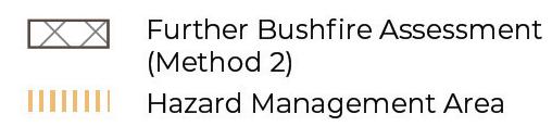
Confirm an appropriate bushfire interface response (such as vegetation management, setbacks or provision of an interface road) to areas marked as “further bushfire assessment (method 2)” on Figure 8.
Confirm preferred bushfire hazard management approach for areas marked as “hazard management area” in Figure 8. This could include vegetation management, provision of interface roads or setbacks consistent with Bushfire Advice Report, North Barker 2025.
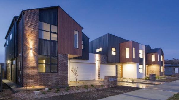
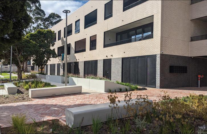
Encourage diverse housing types including townhouses and low-rise apartments) within the 200m walkable catchments of activity and amenity (Figure 8 and 9), consistent with the guiding principles of the Launceston Housing Plan 2025 – 2040.
Launceston Housing Plan 2025 – 2040
The Housing Plan identifies key challenges around affordability, housing inequality, shortage of new homes and lack of diversity. It establishes guiding principles to improve housing supply and diversity in well-located vibrant neighbourhoods. The Neighbourhood Plan implements the relevant principles and actions of the Housing Plan.


Support areas of serviced (with a water and sewer connection) low-density housing in areas which contain significant slope, vegetation, natural values, bushfire hazards, flooding or other land use constraints (Figure 8).
Encourage the delivery of social and affordable housing within the growth area, consistent with the Launceston Housing Plan 2025 – 2040 and as identified in Figure 8.
Establish a retail hierarchy within the walkable catchment of the growth area community Figure 8 (also discussed in Strategic Direction 3). The hierarchy should:
• Support the St Leonards Village and Waverley Activity Centres as a Neighbourhood or Town Centres, as per the NTRLUS Activity Centre Hierarchy.
• Establish a new Neighbourhood or Town Centre to be located centrally within the growth area.
• Consider a future limited-line supermarket and potential supporting retail in the southwest of the growth area, subject to future market trends and retail demand.


Deliver a catchment wide approach to drainage infrastructure by retaining natural waterways as part of the overall stormwater management system and by delivering infrastructure projects identified on Figure 8. Delivery of infrastructure is discussed in the Implementation section.
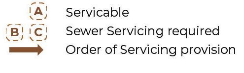
Leverage available water, sewer and power infrastructure for priority housing delivery consistent with Figure 8. Areas marked A, B and C are able to be serviced with water and power infrastructure. Areas marked A are readily serviced by sewer infrastructure. Areas marked B will require a new sewer pipe in the direction shown on Figure 8, to ultimately service area C.
Support planning investigations for the Future Investigation Areas (Figure 8) to determine their suitability for urban development when the following can be demonstrated:
• Genuine land supply need.
• Ability to bring forward connection to the servicing network (water, sewer and power).
• Ability to provide supporting infrastructure (transport, drainage and open space).
The investigations for the Future Investigation Areas should demonstrate the preferred design outcomes as identified on Figure 12.

Confirm suitable land use for area identified on Figure 8 as potentially contaminated, such as provision of an open space area or widened road reservation.
These areas are identified in the Neighbourhood Plan as suitable for investigation for urban development in the long term. The Investigation Areas will form a logical expansion of the urban area when it can be demonstrated there is a land supply need and the land is capable to support urban development.
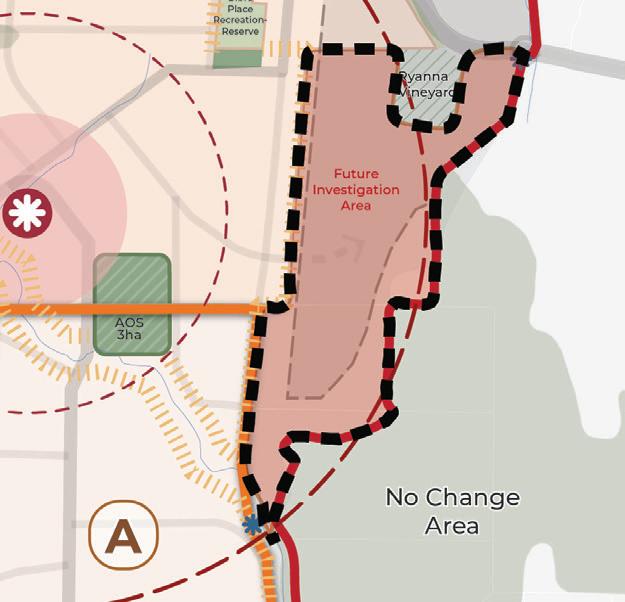
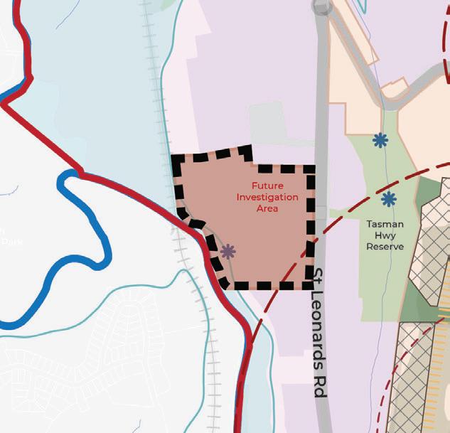
Future Investigation Area 1 should:
• Retain existing vegetation to preserve natural values.
• Respect the growth area boundary.
• Respond sensitively to the existing vineyard to the north, through the application of land use buffers, low-density residential outcomes or design requirements (consistent with the findings of the Agricultural Land Capability Assessment, GES 2025).
Future Investigation Area 2 should:
• Be investigated for an industrial land use consistent with surrounding development, subject to an industrial / commercial land supply and demand assessment.
• Support the development of the North Esk River Trail and provide a link between the Tasman Highway Reserve and the North Esk River.
• Ensure access and built form outcomes respond positively to the slope of the land.
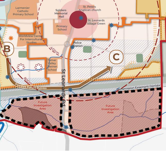
Future Investigation Areas 3 and 4 should:
• Land use should be informed by more detailed land capability assessments in accordance with the Agricultural Land Capability Assessment, GES 2025.
• Respond to flooding, natural values, electricity transmission line easement and Aboriginal heritage.
• Connect areas west and east of St Leonards Road by a high-amenity green-link connection using the transmission easement as a vegetation corridor.
• Ensure a gradual transition from low-density residential areas to rural regions further south.
• Provide an appropriate interface between development and adjacent rural land.
FIGURE 12. PREFERRED DESIGN OUTCOMES FOR THE FUTURE INVESTIGATION AREAS
A summary of the Council and proponent actions are detailed below. Refer to the Implementation section for a detailed overview of the Actions and associated sub-tasks (where relevant), responsibilities and timing.
CATALYST PROJECT 1
Rezone the northern new development area (referred to as Planning Implementation Precinct 1 in the Implementation section) and prepare a Specific Area Plan to unlock new housing and amenities.
A1 Incorporate the Neighbourhood Plan into future updates to the NTRLUS, including the growth area boundary, proposed new development areas and identified infrastructure provision.
A2 Prepare Planning Scheme Amendments to rezone land to unlock new development areas identified on Figure 8 and detailed in the Implementation section.
A3 Prepare a Planning Scheme Amendment to introduce Specific Area Plans (SAP) to embed the Neighbourhood Plan requirements into the Launceston Local Provisions Schedule of the Tasmanian Planning Scheme as identified in the Implementation section.
A4 Advocate to Homes Tasmania to identify future social housing sites within the growth corridor.
A5 Advocate to local Community Housing Providers and developers to explore opportunities for the delivery of affordable housing.
A6 Work with TasWater and TasNetworks to ensure appropriate sewer, water and power infrastructure planning occurs to unlock the new development areas in Figure 8, consistent with the timing identified in the Implementation section.
A7 Establish an internal Council Project Working Group responsible for cross Council Implementation and Monitoring and Review of the Neighbourhood Plan and the IFF, as detailed in the Monitoring and Review section.
A8 Complete a detailed agricultural land suitability assessment of land identified on Figure 8 as Class 3, Class 4 or within a Tasmanian Irrigation District, prior to lodging a rezoning request.
A9 Complete a detailed bushfire report to confirm an appropriate development interfaces for areas marked as “further bushfire assessment (method 2)” and “hazard management area” on Figure 8.
A10 Complete a retail demand assessment to investigate the need for a limited-line supermarket (as identified for Possible Future Activity Centre site in Figure 8) as part of any future rezoning process. If a supermarket site (and potential supporting retail) is deemed required, deliver a master plan for the site.
A11 Complete the required investigations of Future Investigation Areas (Figure 8 and 13) for urban development, subject to a demonstrated land supply need and ability to deliver necessary infrastructure.
A12 Prepare Planning Scheme Amendments to unlock new development areas identified in Figure 8 and detailed in the Implementation section.
A13 Deliver a master plan for the “Proposed Future Activity Centre” as per Figure 8 and Table 3.
A14 Complete a detailed natural values assessment to confirm the extent of natural values to be protected as part of future development.
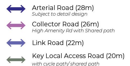

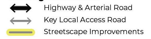


Develop a comprehensive primary movement network as outlined in Figure 13, creating an interconnected transport system for all modes that links people of all abilities to areas of amenity and services.
Key features of this primary movement network include:
A high-amenity movement north-south spine, that supports a connection between new and existing activity centers and associated walkable catchments (see Appendix A, Cross Section A for a supported cross-section).
A cycle-friendly Link Road, connecting Regent Street to the new proposed activity centre, through to St Leonards Road via Norah Street to provide an appropriate transition point from the existing road to new road, (see Appendix A, Cross Section B for a supported cross-section, and Transition B for supported transition plans).
A highly connected Key Access Road network, that delivers shared-user paths and provides connections to open spaces, key view lines, and that offer significant connections for pedestrians, cyclists, and vehicles (see Appendix A, Cross Section C for a supported cross-section).
Support vehicle and active transport movement within and between neighbourhoods through a connected, safe, and high-quality network of secondary streets. This strategy will be achieved by:
Ensuring subdivision applications provide a permeable street network of local streets, each less than 200m in length, that supports the higher order road network as shown in Figure 13 (see Appendix A, Cross Section D for a supported cross section). Where appropriate, short segments of local streets may be replaced with green pedestrian links to address intersection conflicts or provide additional vegetation buffers (see Figure 13).
Implementing road cross sections specified in Figure 13 and Appendix A, consistent with the Tasmanian Municipal Standard Drawings 2020.
Implementing transition points between the existing road network and new road (See Appendix A, Transition A-C for supported transition points)
Promote diverse streets for various housing types, provide more shade along pedestrian routes, and manage car park demand. Aim for connectivity and views to parks and waterways.
Promote walking and cycling by creating a connected network of paths and bicycle lanes linking people to activity areas, open spaces, and community uses. Specific strategies include:
Ensuring subdivision plans provide for a connected network of shared paths and bi-directional bicycle lanes (bi di).
Encouraging inclusion of safe pedestrian and cycle connections between established and new open spaces, (see Appendix A Cross Section F for a supported cross section)
Enhancing safety and amenity on key roads and pedestrian links such as St Leonards Road, Station Road/Benvenue Road, and Regent Street. Appendix A includes supported road crosssections for upgrades and transitions points.
Providing shared paths along linear open space links, including investigating a shared path connection along the North Esk River linking the growth corridor to the existing Hoblers Bridge Trail to provide a connection to the Launceston CBD (Figure 13).
Delivering the proposed shared link between the Tasman Highway to Waverley Road to provide a safe and direct pedestrian connection through to Hoblers Bridge Road from Waverley.
Enhance the public transport network by expanding the bus routes to serve the growth corridor and connect key activity hubs (see Figure 13 for bus-capable roads).
Protect St Leonards Village Activity Centre by supporting the diversion of vehicle traffic onto Johnston Road (Figure 13).
Protect and enhance existing waterways, as high-amenity, multi-functional linear open space corridors that become the focus for connectivity and active transport, this includes protecting the central waterway as a key connection between the proposed activity centre and open space walkable catchments. (see Appendix A Cross Section E for a supported cross-section).
Recognising important potential strategic road connections that will support growth in the corridor and across the broader region, such as the new link road project (Hoblers Bridge Road to Henry Street).
A summary of the Council and proponent actions are detailed below. Refer to the Implementation section for a detailed overview of the Actions and associated sub-tasks, responsibilities and timing.
CATALYST PROJECT 2
Prepare streetscape masterplans for the constructed sections of Station Road / Benvenue Road and Regent Street which identify opportunities for footpath widening, street furniture and tree planting opportunities consistent with the aspirations of the City of Launceston Urban Greening Strategy 2023 – 2040.
A15 Investigate delivery of the Hoblers Bridge Road to Henry Street link road.
A16 Work with the Department of State Growth to prepare a streetscape masterplan for St Leonards Road.
A17 Prepare streetscape masterplans for the constructed sections of Station Road / Benvenue Road and Regent Street.
A18 Allocate funding through Council’s Capital Works Program or advocate for grant funding for the implementation of the streetscape master plans for St Leonards Road, Station Road / Benvenue Road and Regent Street.
A19 Prepare a concept design of the bypass road to divert vehicle traffic away from the St Leonards Village Activity Centre onto Johnston Road (Figure 13).
A20 Advocate to the Department of State Growth for improved bus services.
A21 Investigate the feasibility of a North Esk River Trail to connect from the existing St Leonards Picnic Ground and Dog Run to the to the existing Hoblers Bridge trail that links into the Launceston CBD.
A22 Prepare a detailed design for a new shared path connection from Tasman Highway to Waverley Road. Allocate funding through Council’s Capital Works Program or advocate for grant funding for its construction.
A23 Deliver road cross sections consistent with Figure 13 and Appendix A.
A24 Prepare a streetscape masterplan for the high amenity north-south spine road and transition point with Humphrey Street consistent with Cross Section A (Appendix A).
- Alignment with Cross Section A (Appendix A).
- Canopy tree planting a consistent with the aspirations of the City of Launceston Urban Greening Strategy 2023 – 2040.
A25 Prepare a streetscape masterplan for the proposed extension of Norah Street and the transition point to the existing constructed road, including appropriate cycling infrastructure.

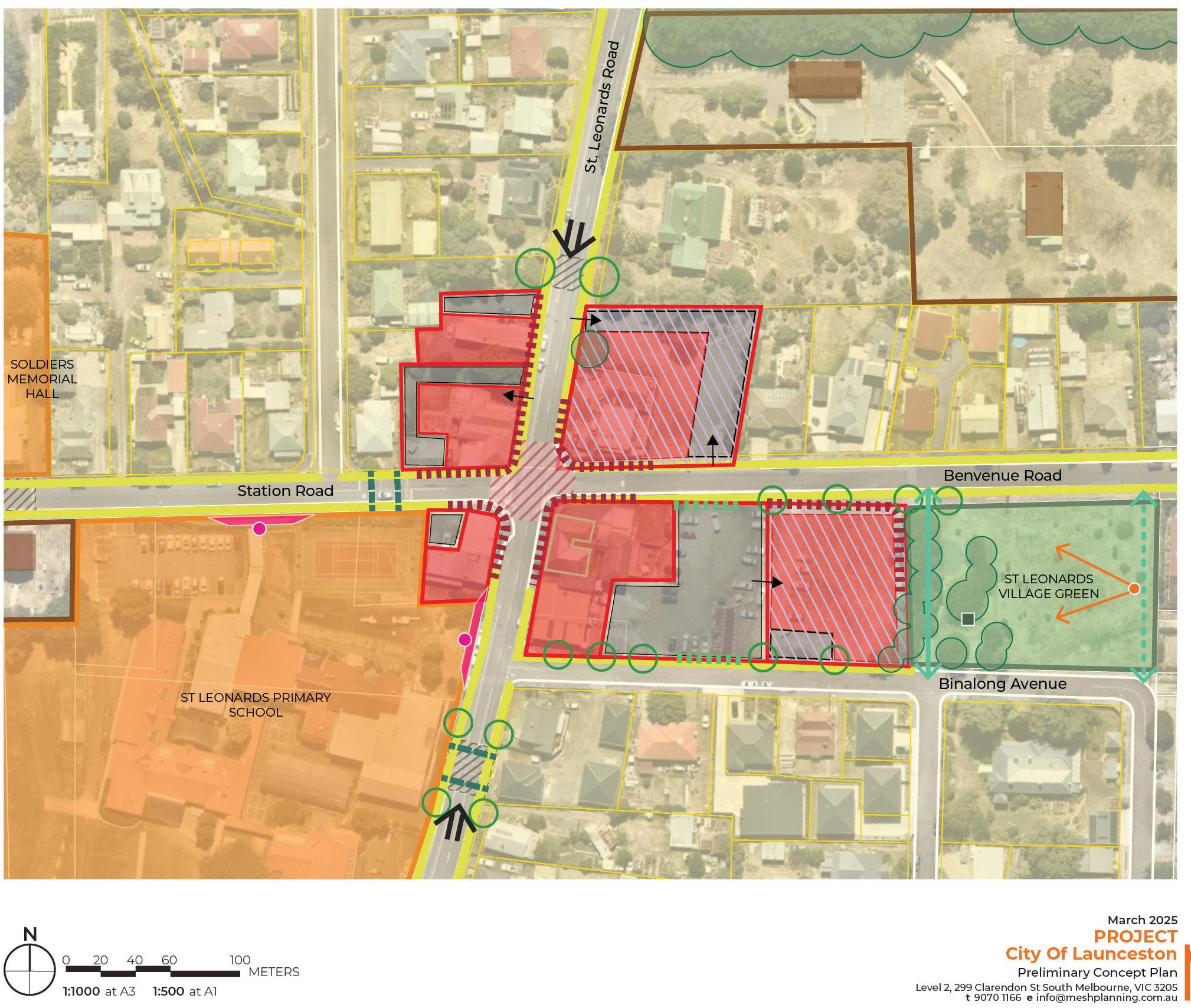
Enhance the scale and retail and service offer of the St Leonards Village as identified in Figure 14 and Table 2, consistent with the St Leonards Structure Plan – Retail and Community Infrastructure Needs Analysis, Geografia 2025.
POTENTIAL USES
FLOOR SPACE ALLOCATION
Local Grocer 1,500sqm
Supporting Retail 1,500sqm
Food & Beverage 2,000sqm
Other uses with identified demand:
• General Practice
• Childcare
• Child Health and Parenting Services (CHaPS)
2.


This to be determined by the market. These uses are to be distributed between St Leonards Village and new Neighbourhood Activity Centre.
Support a new neighbourhood activity centre to service the northern portion of the growth corridor consistent with Table 3.
POTENTIAL USES
FLOOR SPACE ALLOCATION
Local Grocer 850sqm
Supporting Retail 2,000sqm
Food & Beverage 2,500sqm
Other uses with identified demand:
• General Practice
• Childcare
• Child Health and Parenting Services (CHaPS)


This to be determined by the market. These uses are to be distributed between St Leonards Village and new Neighbourhood Activity Centre.
TABLE 3. NEW ACTIVITY CENTRE POTENTIAL USES AND FLOOR SPACE ALLOCATION
Enhance the existing Waverley local town centre by supporting uses that encourage activation of the centre, including retail, food and beverage services.
Understand, protect, and acknowledge Aboriginal heritage significance, including preserving significant Aboriginal heritage sites identified on Figure 14, as supported by the St Leonards Structure Plan Aboriginal Heritage Assessment, ACHMA 2024.
Recognise valued historic heritage and neighbourhood character though implementation of the recommendations from the Historical Heritage Assessment, ACHMA 2024 as follows:
• Protect properties that are identified on the Tasmanian Heritage Register (Figure 14).
• Retain historic landscape features as part of new development, including boundary hedges, stone fences, winding lanes, stands of exotic trees associated with historic homesteads to preserve the character of the area.
Support high-quality built form design outcomes that respond to the existing and emerging character of the growth corridor and sensitively responds to the planned density of development.
Deliver new open space that fills the gaps in the network for walkable neighbourhoods in line with the Draft City of Launceston Recreation and Open Space Strategy (Figure 14). Delivery of open space projects is discussed in the Implementation section.
Deliver a new sports and recreation facility that comprises an oval, small pavilion and a multi-purpose outdoor court consistent with the recommendations of the St Leonards Structure Plan – Retail and Community Infrastructure Needs Analysis, Geografia 2025.


Enhance and elevate the role of existing open spaces through delivery of the projects identified in Table 4, consistent with the Draft City of Launceston Recreation and Open Space Strategy.
EXISTING OPEN SPACE AREA
CLASSIFICATION (AS PER DRAFT CITY OF LAUNCESTON RECREATION AND OPEN SPACE STRATEGY) DESCRIPTION
Bibra Place Recreation Reserve Uplift to Neighbourhood Park


Waverley Lake Park
St Leonards Picnic Ground and Dog Run
Neighbourhood Park
Deliver improved amenities which could include facilities such as public toilets, accessible play spaces, parking and a basketball court.
Deliver improved shared path connections.
Neighbourhood Park Deliver improved path connections, play facilities, parking and river access.
Tasman Highway Reserve Local Open space Formalisation of open space through weed removal and delivery of path network and re-vegetation.
St Leonards Village Green Uplift to Neighbourhood Park Deliver improved recreation options which could include facilities such as exercise equipment, skate park and climbing gym equipment.
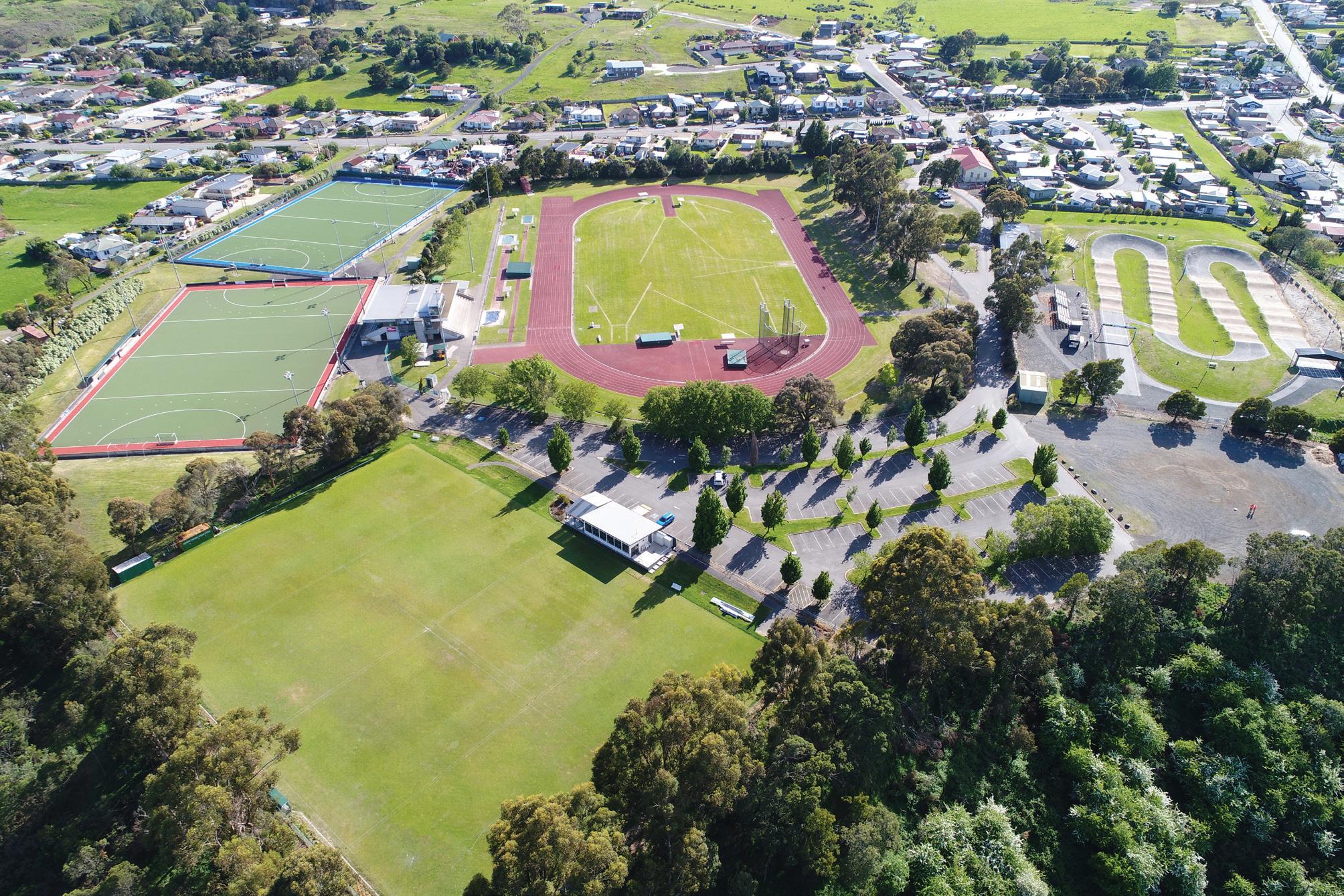
St Leonards Sport Centre Sports Facility Engage with lease holders to seek to achieve greater community access to current facilities. Identify opportunities for improved seating, shade, toilets and nature play.
TABLE 4. PROPOSED OPEN SPACE PROJECTS
Retain existing waterway corridors and focus on replanting projects to support habitat and contribute to neighbourhood character, including delivery of the Central Waterway corridor (see Appendix A, Cross Section E for a supported cross section).
Provide community infrastructure that meets the future needs of the growth area, consistent with the recommendations of the St Leonards Structure Plan – Retail and Community Infrastructure Needs Analysis, Geografia 2025 (Table 5).
COMMUNITY
INFRASTRUCTURE LOCATION DESCRIPTION
Soldiers Memorial Hall upgrades 14 Station Road St Leonards Upgrades to the existing Soldiers Memorial Hall in the form of refurbishment to the existing amenities and kitchen facilities, improved storage space to enhance this facility for broader community use.
New Waverley Community Centre
To be defined Define a location for a new local community centre within Waverley to include general purpose meeting spaces, a small commercial kitchen and amenities.
TABLE 5. PROPOSED COMMUNITY INFRASTRUCTURE PROJECTS
Protect areas of vegetation and existing tree patches within road reserves, open space areas and private properties that contribute to the character of the corridor (Figure 14).


Improve the delivery of tree canopy and landscaping outcomes as part of the development approvals process.
Protect and enhance view lines (see A to F) to mountain ranges and destinations within the growth area through careful subdivision design and road alignments (Figure 14).
Improve the entrance to the growth corridor by enhancing the Tasman Highway Reserve as a gateway open space (Figure 14).
Investigate the long term need for a potential future secondary school as shown on Figure 14.
Enhance the north south spine road (marked as B on Figure 14) as a high amenity connection for vehicle and active transport as supported by Strategic Direction 2.
Note: St Leonards Village Improvements under Action A26 on the following page.

CATALYST PROJECT 3
Prepare a landscape masterplan for the Waverley Lake Park that identifies opportunities for improved shared path connections, consistent with the Draft City of Launceston Recreation and Open Space Strategy.
A26 Prepare a master plan for the St Leonards Village (label B, on Figure 14) that examines the development opportunities shown on Figure 15.
A27 Implement the recommendations of the Historical Heritage Assessment, ACHMA 2025.
A28 Prepare a Landscape Master Plan for the Tasman Highway Reserve.
A29 Prepare Landscape Master Plans for the existing open space projects identified in Table 4, the proposed sport and recreation facility and the new open space areas identified on Figure 14.
A30 Prepare a detailed design for the upgrade to the Soldiers Memorial Hall (as per Table 5).
A31 Investigate delivery of a new small community facility in Waverley as per Table 5.
A32 Prepare Landscape Design Guidelines that are used by Council to assess landscape master plans prepared by proponents.
A33 Prior to rezoning, engage with the Department of Education, Children and Young People (DECYP) to confirm the need for a secondary school site (Figure 14). If no commitment can be made by DECYP to secure the land, the land will revert to the underlying future land use (residential).
A34 Work with the Department of Health to identify suitable locations for the delivery of Child Health and Parenting Services (CHaPS). Consider locations within existing or proposed activity centres aswell as the potential to use proposed community infrastructure for these services.
A35 Develop Landscape Master Plans that consider the proposed high amenity waterway corridor consistent with Appendix A, Cross Section E. The landscape master plans should identify opportunities for re-vegetation of the corridor and provision of a shared path connection for a high amenity public open space.
Putting a Neighbourhood Plan into action involves a range of different implementation steps (Figure 16). This chapter describes those steps, when they should be taken and who is responsible for leading the change.
Firstly, there are statutory implementation steps to ensure the Launceston Local Provisions Schedule of the Tasmanian Planning Scheme is updated to reflect the strategies and plans contained within the document. This includes rezoning and preparing more detail statutory planning guidance for specific areas. These are critical for setting the planning framework for future development applications.
Infrastructure delivery is a critical yet complex area of implementation. The IFF will set out the higher order shared infrastructure projects and the approach to how these will be funded and delivered, to unlock the staged delivery of the growth area.
Lastly, there are general actions that may involve further investigations or advocacy efforts to support the long-term vision for the area. These actions might include advocacy, more detailed planning and design processes, environmental assessments, or partnerships with various stakeholders to achieve broader goals. Some actions are required to occur to inform statutory implementation.
Actions
Further work to achieve the Vision and Strategic Directions
Statutory Implementation
Rezonings and application of SAPs
Infrastructure Funding Framework
Requirement to enter into Agreement under Section 71 of the Land Use Planning and Approvals Act 1993
Some Actions will inform rezonings + application of SAPs
Statutory implementation involves amending the Launceston Local Provisions Schedule of the Tasmanian Planning Scheme, so future development applications are submitted consistent with the Neighbourhood Plan. Statutory Implementation is in the form of rezoning and application of Specific Area Plans (SAPs).
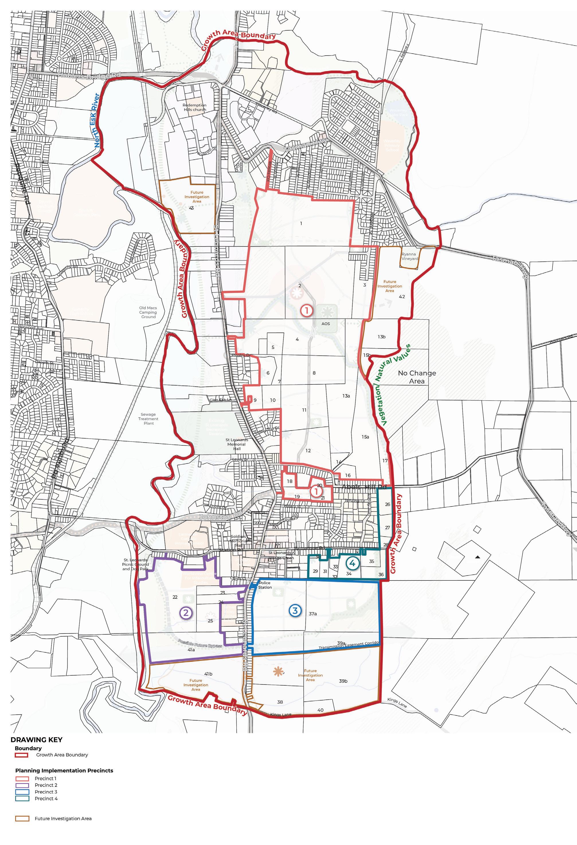
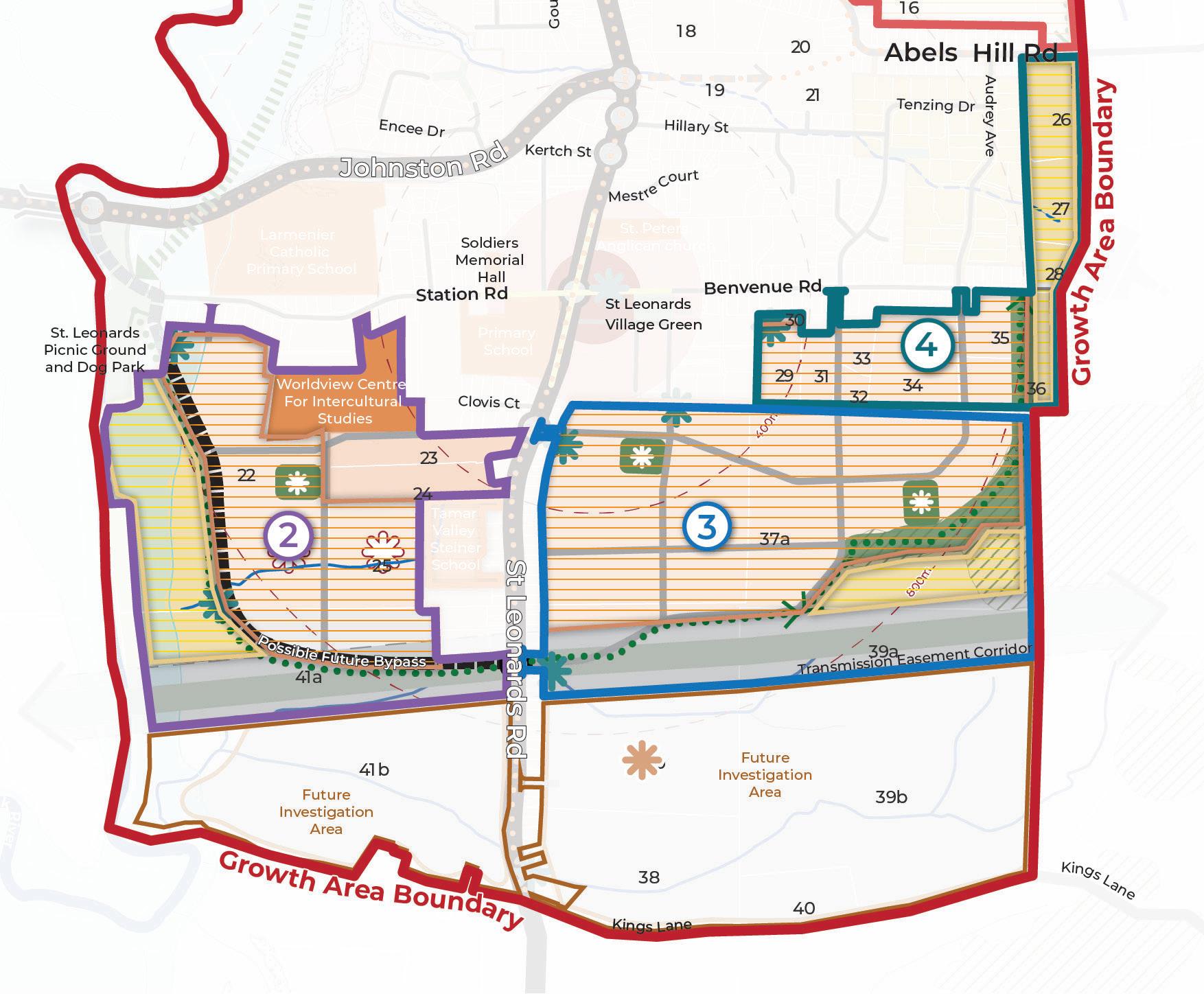
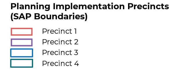
Statutory Implementation will occur consistently with four Planning Implementation Precincts (Figure 17) where a staged approach to rezoning and application of SAPs will occur as detailed below.
The Planning Implementation Precincts have been defined based on:
• Land ownership boundaries
• Access to existing higher order infrastructure
• Servicing catchments (water, sewer, power)
• Drainage catchments
• Ability to stage development with infrastructure delivery

Specific Area Plans (SAP) will be used as the mechanism to provide guidance on areas where a unique development outcome is being sought. SAPs are proposed to implement the Neighbourhood Plan to give it statutory effect, so the plans directions are responded to as part of development applications.
A SAP is proposed for each Planning Implementation Precinct to be applied at the time of rezoning (discussed below). Planning Implementation Precincts 1 and 2 include land that’s already zoned for residential purposes, but is not yet developed, the SAP control will also apply to this land.
It is proposed that the two existing SAPs that apply within the growth area are removed at the time that new SAPs are introduced. The existing SAPs are:
• LAU-S4.0 – Hillary Street Specific Area Plan
• LAU-S12.0 – Development Potential Specific Area Plan
The drafting of the SAPs should include the following general guidance:
• Requirement to develop and use land consistent with the Neighbourhood Plan (Figure 7).
• A provision to ensure any short term planning, building or subdivision approvals do not preclude delivery of the Neighbourhood Plan outcomes in the long term.
Specific consideration should be given to inclusion of the following more detailed guidance in each SAP.
At a minimum, the purpose section of each SAP should include:
• Reference to implementing land use and development consistent with the Neighbourhood Plan.
• Reference to the IFF and requirements for funding and delivery of infrastructure.
• The SAP should apply in accordance with the Planning Implementation Precincts in Figure 17, at the time of rezoning as discussed in the next section of the Neighbourhood Plan.
• The Neighbourhood Plan (Figure 7) and any relevant master plans (consistent with the Actions in this document) should be included as Figures within the SAP.
At a minimum, the purpose section of each SAP should include:
• Local Area Objectives should implement the Strategic Directions of the Neighbourhood Plan and reference the relevant strategies for each Planning Implementation Precinct.
• The key strategies to highlight as Local Area Objectives include:
- Aspirations for diverse housing within 200m walkable catchment of the two Activity Centres.
- Provision for road cross sections consistent with the Neighbourhood Plan.
- Aspirations to retain vegetation on site where possible.
- Delivery of sport and recreation and community infrastructure.
- Protection of cultural heritage values
- Protection of historic heritage values.
A SAP can modify, substitute or add to the State Planning Provision (SPP) based on the underlying zone to which the SAP applies. This needs to be clearly identified within the SAP under the relevant headings:
- Use table
- Use standards
- Development standards for building and works
- Development standards for subdivision
At the time of preparing the SAP for each Planning Implementation Precinct, the relevant provisions should be reviewed to determine if any modifications or substitutions are required in order to implement the Neighbourhood Plan. It is likely that the majority of standards will be “in addition” to the standards of a Zone or Code.
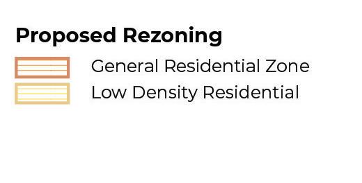
Rezoning is required to translate non-urban zones into urban zones consistent with the Neighbourhood Plan. There are immediate and future rezonings to ensure the development of new housing occurs in a staged way that is aligned with infrastructure delivery. The proposed approach to zone changes are set out in the following sections of the document. While the Neighbourhood Plan has been informed by high level technical investigations (as identified in the Preparing the Neighbourhood Plan section), any planning scheme amendment or development application will need to be accompanied by the necessary technical assessments as required by the Land Use Planning and Approvals Act 1993 and the Tasmanian Planning SchemeLaunceston (such as land contamination, landslip hazard etc).
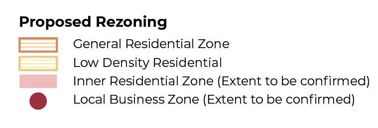
Zoning Acronyms
AZ Agricultural Zone
CPZ Community Purpose Zone
FUZ Future Urban Zone
LCZ Landscape Conservation Zone
LBZ Local Business Zone
GRZ General Residential Zone
RLZ Rural Living Zone
RZ Rural Zone
Planning Implementation Precinct 1 is identified as the immediate area for rezoning (Table 6) as it:
• Has existing access to servicing (water and sewer) infrastructure (as detailed in Strategic Direction 1).
• Will help facilitate a connected transport network.
• Will enable a catchment approach to the delivery of drainage infrastructure.
• Will deliver new community amenities (new activity centre, open space and a sport and recreation facility).
• Includes a range of developers who are ready to progress with development applications.
• Includes opportunities for delivery of diverse housing.
The immediate rezonings are anticipated to occur as soon as practicable upon finalisation of the Neighbourhood Plan (as per Strategic Direction 1 – Catalyst Project 1).
Implementation Precinct 1 includes some land that’s already zoned GRZ, which is considered appropriate. However, with respect to Property 2 some LBZ and IRZ is proposed to also be introduced. Property 2 includes the proposed activity centre, which anticipates uses that aren’t permissible under the GRZ. Therefore, as identified by Action 13, a master planning process is recommended to occur to refine the extent and location of the activity centre site to inform application of the LBZ. This master plan will also identify opportunities for diverse housing (in the form of town house and potentially low rise apartments), its recommended the IRZ be applied to facilitate this form of housing consistent with the master plan.


Planning Precincts 2, 3 and 4 are subject to more detailed work and will be completed by Council or the relevant proponent. The future rezoning areas don’t have timing attributed to them as they will be subject to meeting the identified pre-conditions (Table 7).
PROPERTY & EXISTING ZONE
Planning Precinct 2
22 – RZ
41a – AZ GRZ
Potential for LBZ and IRZ to be applied to property 22.
Council or proponent 22 & 41A:
• Demonstrated land supply need. State Planning policy identifies a 15-year zoned land supply as an appropriate threshold.
• Confirmation of the extent of land to be set aside as flood prone / low density development, consistent with the flood-prone areas Code.
• Resolution of form of proposed bypass road.
• Resolution of provision of water and waste water infrastructure.
• Investigations into demand for half line super market and associated master planning (as identified as pre-condition to property 25)
41A:
• Investigation into agricultural suitability (as detailed by Action 8).
• Preparation of a SAP (to be prepared by Council).
• Section 71 Agreement (see IFF section of document).
25 – RZ GRZ
Potential for LBZ and IRZ to be applied to property 22.
Planning Precinct 3
37a – FUZ GRZ & LDRZ
Council or proponent
• Investigations into demand for a limited line supermarket and associated retail.
• If retail required, completion of a master plan to confirm extent of activity centre site and application of the LBZ.
• Preparation of a SAP (to be prepared by Council).
• Section 71 Agreement (see IFF section of document).
• If the activity centre is required, the master plan should identify appropriate locations for diverse housing to inform application of the IRZ.
Proponent
• Demonstrated land supply need. State Planning policy identifies a 15-year zoned land supply as an appropriate threshold
• Resolution of provision of water and waste water infrastructure.
• Section 71 Agreement (see IFF section of document).
• Investigation into agricultural suitability (as detailed by Action 8).
• Preparation of a SAP (to be prepared by Council).
26 – RLZ LDRZ Council • Demonstrated land supply need. State Planning policy identifies a 15-year zoned land supply as an appropriate threshold
• Resolution of provision of water and waste water infrastructure.
• Preparation of a SAP (to be prepared by Council).
• Section 71 Agreement (see IFF section of document)
A number of Code Overlays apply across the Neighbourhood Plan Area including:
• Local Historic Heritage Code
• Natural Assets Code
• Scenic Protection Code
• Flood-Prone Areas Code
• Bushfire-Prone Areas Code
• Potentially Contaminated Land Code
• Landslip Hazard Code
• Waterway and coastal protection Code
There is an opportunity to review the code mapping as a result of the technical findings and directions of the Neighbourhood Plan. Particularly with respect to Actions 27 in relation to Historic Heritage and the findings of the Natural Values Assessment (identified in Section 6).

The St Leonards and Waverley Infrastructure Funding Framework (IFF) is being prepared to guide the delivery of shared infrastructure projects to service the proposed development of the growth area for housing.
The IFF will:
• Identify the shared infrastructure that is required to support the development of the St Leonards and Waverley growth area;
• Determine the scope, cost, justification and apportionment for shared growth area infrastructure;
• Specify the infrastructure charges payable for the shared infrastructure and the requirement to directly deliver specific infrastructure; and
• Describe how this IFF is to be administered and implemented.
The IFF will be implemented via a SAP with landowners required to enter into an agreement with Launceston City Council, prior to rezoning or subdivision, under Section 71 of the Land Use Planning and Approvals Act 1993 (LUPA).
The IFF is being informed by the land use and development directions identified in the Neighbourhood Plan. Tasmania does not currently have legislation which gives legal effect to a formal infrastructure contributions system, however the IFF is being prepared with regard to the following principles commonly used in infrastructure planning in other states, which are considered to be relevant and appropriate for this project:
NEED clearly establishing the need for the infrastructure
NEXUS identifying and describing the nexus between the number and type of projects included in the IFF and the land it services
SIMPLICITY simplifying the number and type of projects included in the IFF
EQUITY maintaining a fair and equitable distribution of funding obligations
TRANSPARENCY clearly articulating the justification for the infrastructure and calculation of charges
ACCOUNTABILITY ensuring that the IFF obligations are implemented by focusing on development coordination and monitoring and reporting on these obligations.
The infrastructure context is key to informing how projects are funded and delivered. The infrastructure context for St Leonards and Waverley is identified below.
The transport context for the growth area is as follows:
• Road and intersection design approved as part of recent subdivisions has generally been designed to meet the needs of individual applications, rather than the growth area more broadly.
• There are existing capacity constraints on the surrounding road network, in particular the Hoblers Bridge Road / David Street intersection. This is the main intersection used by vehicles travelling from St Leonards and Waverley into the Launceston CBD. Council is investigating a new road link to provide an alternative access route, referred to as the Henry to Hoblers connection.
• St Leonards Road is the key arterial providing access to the growth area. The majority of traffic generated from the growth area will access this road. This traffic will mostly travel north and for this reason, upgrades to existing intersections and new signalised intersections along St Leonards Road are a priority.
• There are limited opportunities for new access points off St Leonards Road into the growth area, due to the existing development footprint with several constructed buildings along St Leonards Road.
• There are a number of existing destinations along St Leonards Road that have existing access points (i.e. existing industrial development and the St Leonards Sports Centre).
• The bus network will need to be extended to service the proposed growth of St Leonards and Waverley.
The drainage context for the growth area is as follows:
• Stormwater management infrastructure approved as part of recent subdivisions has generally been designed to meet the needs of individual applications, rather than a catchment wide solution to managing stormwater.
• Stormwater utilises a number of pipes under St Leonards Road to outfall to the North Esk River. There are some existing capacity and functionality constraints with this pipe infrastructure. Council will be responsible for addressing existing functionality constraints with the existing network
• Drainage catchments don’t align with property boundaries, but the catchments fall within the proposed new development areas.
The sport & recreation, open space and shared path context for the growth area is as follows:
• Council is currently finalising a new open space strategy for the municipality, the Draft Recreation and Open Space Strategy (ROSS).
• There are a number of existing local parks within the growth area, the draft ROSS anticipates upgrades to a number of these to be delivered by Council.
• The St Leonards Sports Centre is also located within the growth area. This Centre is currently leased and therefore use of the facility is restricted for general community use. The ROSS seeks to investigate ways this facility can be better accessed by the community in addition to identifying opportunities for value-additions such as play equipment and picnic facilities.
• The Northern Tasmania Netball Association courts are located in close proximity to the growth area on Hoblers Bridge Road.
• There is currently an under provision of both passive and active open space at a suburb level for St Leonards and Waverley.
• There are opportunities to formalise the shared path network that services the Waverley Lake Park to improve this local open space area.
• An aspirational shared path has been discussed for a number of years along the North Esk River. This would connect into the existing Hoblers Bridge trail that connects through Newstead into the Launceston CBD and onto Kings Bridge.
The community infrastructure context for the growth area is as follows:
• There are existing community halls within the St Leonards are that are owned by Council and leased to community groups.
• There is demand for improved access to community facilities for the growth area.
The approach to delivery and funding of infrastructure will be informed by the principles and infrastructure context discussed above.
The IFF will guide the funding and delivery of shared higher order infrastructure. Where infrastructure projects benefit an individual developer these projects will remain as normal developer delivered subdivision projects.
Shared infrastructure have been categorised as identified in Table 8, the two categories of infrastructure are precinct specific infrastructure and growth area infrastructure depending on the direct benefitting catchment.
INFRASTRUCTURE CATEGORY INFRASTRUCTURE
Precinct Specific Infrastructure
Likely to include Drainage and Transport projects.
Benefit and cost of this infrastructure shared across an implementation precinct (as detailed in the Statutory Implementation section above).
Growth Area Infrastructure
Likely to include Sports and Recreation, Transport and Community Infrastructure projects
Growth area infrastructure benefits all new development within the growth area and therefore the costs are apportioned across all new development.
Shared infrastructure will either be delivered by a developer or by Council (Table 9). Developers will deliver projects as Works In Kind (WIK)1, where there is no logical WIK opportunity Council will be responsible for the delivery of the project. Developers will pay a shared infrastructure levy to contribute to the cost of the shared projects.
INFRASTRUCTURE CATEGORY INFRASTRUCTURE
Developer delivered as Works In Kind (WIK) project
Council delivers project
Likely to include Drainage and Transport projects.
Likely to include Drainage, Sports and Recreation, Transport and Community Infrastructure projects.
Developer delivers precinct specific and/or shared infrastructure and is credited the cost via the IFF.
Council delivers infrastructure that is funded through shared infrastructure levy.
Once finalised the IFF will be embedded into this chapter of the Neighbourhood Plan document. The next steps to finalise the IFF include:
• Refinement of project designs and costs and finalisation of list of projects that form precinct specific and growth area infrastructure.
• Development of shared infrastructure levy.
• Finalisation of project list to be delivered directly by developers as WIK.
• Implementation and administration components of the IFF.
Once the IFF has been finalised there will be further targeted engagement.
1 Works In Kind (WIK) – Is an agreement between a Council and a land owner to provide land or construction services instead of paying a cash fee.
Table 10 identifies the Actions required to Implement the Neighbourhood Plan.
The elements of the Action table are:
• The description of the action includes the main task, in some instance there are sub-tasks that will also be required to be completed.
• The responsibility column identifies who will be responsible for leading delivery of the action. Where both Council and an agency is identified, Council will lead the action in partnership with the agency. A proponent action will be led by the developer or other key relevant stakeholder.
• The timing column is identified as either immediate, short, medium or long term. The immediate category applies to the Catalyst Projects as actions Council will proceed with as soon as practicable possible upon finalisation of the Neighbourhood Plan. Short term actions are intended to occur within 0 – 5 years, medium term are within 5 – 10 years and long term actions are beyond 10 years.
Catalyst Project 1
Rezone the northern new development area (referred to as Planning Implementation Precinct 1 in the Implementation section) and prepare a Specific Area Plan to unlock new housing and amenities.
A1 Incorporate the Neighbourhood Plan into future updates to the NTRLUS, including the growth area boundary, proposed new development areas and identified infrastructure provision.
A2 Prepare Planning Scheme Amendments to rezone land to unlock new development areas.
Council or proponent (see Statutory Implementation section)
A3 Prepare a Planning Scheme Amendment to introduce Specific Area Plans (SAP) to embed the Neighbourhood Plan requirements into the Launceston Local Provisions Schedule of the Tasmanian Planning Scheme as identified in the Implementation section. Council or proponent (see Statutory Implementation section)
A4 Advocate to Homes Tasmania to identify future social housing sites within the growth corridor.
A5 Advocate to local Community Housing Providers and developers to explore opportunities for the delivery of affordable housing.
Short to long term
to long term
Council or proponent Homes Tasmania Short to long term
Council or proponent Community Housing Providers Short to long term
A6
Work with TasWater and TasNetworks to ensure appropriate sewer, water and power infrastructure planning occurs to unlock the new development areas in Figure 8, consistent with the timing identified in the Statutory Implementation
A7 Establish an internal Council Project Working Group responsible for cross Council Implementation and Monitoring and Review of the Neighbourhood Plan and the IFF, as detailed in the Monitoring and Review section.
A8 Complete a detailed agricultural land suitability assessment of land identified on Figure 8 as Class 3, Class 4 or within a Tasmanian Irrigation District, prior to lodging a rezoning request.
A9 Complete a detailed bushfire report to confirm an appropriate development interfaces for areas marked as “further bushfire assessment (method 2)” and “hazard management area” on Figure 8.
A10
A11
Complete a retail demand assessment to investigate the need for a limited-line supermarket (as identified for Possible Future Activity Centre site in Figure 8) as part of any future rezoning process. If a supermarket site (and potential supporting retail) is deemed required, deliver a master plan that identifies:
• Location and extent of limited line supermarket and any associated retail needs and associated extent of Local Business Zone that should apply.
• Opportunities for delivery of diverse housing associated with the activity centre site, to be rezoned to Inner Residential Zone.
Complete the required investigations of Future Investigation Areas (Figure 8 and 13) for urban development, subject to a demonstrated land supply need and ability to deliver necessary infrastructure.
A12 Prepare Planning Scheme Amendments to unlock new development areas identified in Figure 8 and detailed in the Implementation section.
A13
A14
Deliver a master plan for the “Proposed Future Activity Centre” as per Figure 8 and Table 3 that identifies:
• the mix of uses consistent with the recommendations of the St Leonards Structure Plan – Retail and Community Infrastructure Needs Analysis, Geografia 2025, including identification of a land area to which the Local Business Zone should apply.
• Identification of locations suitable for diverse housing such as town houses and low rise apartments, and subsequent extent of re-zoning to the Inner Residential Zone.
• Location of a local grocer.
• Interface treatment to new proposed Sport and Recreation infrastructure.
• Streetscape treatment, including wayfinding, and interfaces to diverse housing outcomes.
• Landscape outcomes including tree planting opportunities and enhancement of the retained waterway as a key open space and amenity feature.
Complete a detailed natural values assessment to confirm the extent of natural values to be protected as part of future development.
Council TasWater TasNetworks Short to long term
Council Short
Proponent Short to long
Proponent Short to long
Proponent Short
Proponent Long
Council or proponent Short to long
Proponent Short
Proponent Short to long
Catalyst Project 2
Prepare streetscape masterplans for the constructed sections of Station Road / Benvenue Road and Regent Street which identify opportunities for footpath widening, street furniture and tree planting opportunities consistent with the aspirations of the City of Launceston Urban Greening Strategy 2023 – 2040.
A15 Investigate delivery of the Hoblers Bridge Road to Henry Street link road connection by:
• Confirming a preferred alignment and completing detailed design.
• Advocating for grant funding for the roads delivery, in consultation with the Department of State Growth.
A16 Work with the Department of State Growth to prepare a streetscape masterplan for St Leonards Road which identifies:
• Opportunities for improved safety for on-road cyclists, such as painted cycle lanes and signage.
• Opportunities for improved pedestrian safety through footpath widening and provision of paths on both sides of the road.
• Tree planting opportunities consistent with the aspirations of the City of Launceston Urban Greening Strategy 2023 – 2040.
• Opportunities for improved and consistent signage to support businesses.
• Entry signage / treatment opportunities at each end to mark arrival into the corridor.
A17 Prepare streetscape masterplans for the constructed sections of Station Road / Benvenue Road and Regent Street which identify:
• Opportunities for footpath widening.
• Tree planting opportunities consistent with the aspirations of the City of Launceston Urban Greening Strategy 2023 – 2040.
A18 Allocate funding through Council’s Capital Works Program or advocate for grant funding for the implementation of the streetscape master plans for St Leonards Road, Station Road / Benvenue Road and Regent Street.
A19 Prepare a concept design of the bypass road to divert vehicle traffic away from the St Leonards Village Activity Centre onto Johnston Road (Figure 13). The design should include:
• A shared user path that connects users from St Leonards Road to the St Leonards Picnic Ground and Dog Run and linking to the aspirational North Esk River Trail.
• Tree planting opportunities consistent with the aspirations of the City of Launceston Urban Greening Strategy 2023 – 2040.
A20 Advocate to the Department of State Growth for improved bus services including:
• A new bus route utilising the bus capable road network identified in Figure 13.
• Increased service frequency in the form of a “Turn up and Go” service as is delivered along Invermay Road, servicing Newnham and Mowbray.
A21 Investigate the feasibility of a North Esk River Trail to connect from the existing St Leonards Picnic Ground and Dog Run to the existing to the existing Hoblers Bridge trail that links into the Launceston CBD including:
• Prepare alignment options that consider topography, safety, cost and accessibility.
• Prepare a detailed design and cost for the trail.
• Advocate for funding for its delivery.
A22 Prepare a detailed design for a new shared path connection from Tasman Highway to Waverley Road. Allocate funding through Council’s Capital Works Program or advocate for grant funding for its construction.
A23 Deliver road cross sections consistent with Figure 13 and Appendix A.
A24 Prepare a streetscape masterplan for the high amenity north-south spine road and transition point with Humphrey Street consistent with Cross Section A (Appendix A).
• Alignment with Cross Section A (Appendix A).
• Canopy tree planting a consistent with the aspirations of the City of Launceston Urban Greening Strategy 2023 – 2040.
A25 Prepare a streetscape masterplan for the proposed extension of Norah Street and the transition point to the existing constructed road, including appropriate cycling infrastructure.
Council Immediate
Council Department of State Growth Short
Council Department of State Growth Short to Medium
Council Short to Medium
Council Short to Medium
Council Medium to Long
Department of State Growth Short
Council Short
Council Short
Proponent Short to Long
Proponent Short to Medium
Proponent Short to Medium
Catalyst Project 3
Prepare a landscape masterplan for the Waverley Lake Park that identifies opportunities for improved shared path connections, consistent with the Draft City of Launceston Recreation and Open Space Strategy.
A26 Prepare a master plan for the St Leonards Village (label B, on Figure 14) that examines the development opportunities shown on Figure 16, including:
• Encourage investment in the St Leonards village to deliver objectives of the Master Plan.
• Detail of public realm upgrades, including built form and landscape requirements.
• Implement the Policy recommendations as identified on page 112 of the Launceston Heritage Study – Summary Report and Recommendations 2007.
• Transport safety improvements through delivery of a signalised intersection at Station Road and St Leonards Road (see Implementation section).
Following completion of the master plan, confirm required statutory implementation which may include rezoning the site on the corner of St Leonards Road and Benvenue Road to Local Business Zone and potential introduction of a SAP.
A27 Implement the recommendations of the Historical Heritage Assessment, ACHMA 2025 by:
• Conducting a full heritage assessment of “The Grange” at 356 St Leonards Road.
• Listing state significant properties from the Launceston Heritage Study 2007 –Places of State Significance Site Inventory on the Tasmanian Heritage Register.
• Include locally significant properties identified in the Launceston Heritage Study 2007 – Places of Local Significance Site Inventory through introduction of a Heritage Precinct in Table C6.2 of the Launceston Local Provisions Schedule – Historic Heritage Code.
A28 Prepare a Landscape Master Plan for the Tasman Highway Reserve, that identifies:
• Improved entry signage from the Tasman Highway, St Leonards Road and growth corridor interfaces.
• Opportunities for improved shared pathways through the reserve.
• Weed removal and improved landscaping and public open space.
A29 Prepare Landscape Master Plans for the existing open space projects identified in Table 4, the proposed sport and recreation facility and the new open space areas identified on Figure 14.
Council Immediate
Council Short
Council Short
Council Short
Council Short to Medium
A30 Prepare a detailed design for the upgrade to the Soldiers Memorial Hall (as per Table 5). Council Short
A31 Investigate delivery of a new small community facility in Waverley as per Table 5 including:
• Selection of a suitable site.
• Confirmation of scope of facility.
• Advocate for grant funding for its delivery.
A32 Prepare Landscape Design Guidelines that are used by Council to assess landscape master plans prepared by proponents. These guidelines should:
• Implement the aspirations of the City of Launceston Urban Greening Strategy 2023 – 2040
• Consider landscaping on nature strips, open space and waterway corridors.
• Identify an appropriate species planting list.
Council Short
• Encourage proponents to retain existing vegetation on site as part of subdivision design, where possible. Council
A33 Prior to rezoning, engage with the Department of Education, Children and Young People (DECYP) to confirm the need for a secondary school site (Figure 14). If no commitment can be made by DECYP to secure the land, the land will revert to the underlying future land use (residential). Steps to include:
• Identification of preferred site which considers access arrangements, walkable catchments, land area requirements and bushfire hazard management.
• Confirmation of the land take required and mechanism for securing this land.
A34 Work with the Department of Health to identify suitable locations for the delivery of Child Health and Parenting Services (CHaPS). Consider locations within existing or proposed activity centres aswell as the potential to use proposed community infrastructure for these services (see Action 30 and 31).
A35 Develop Landscape Master Plans that consider the proposed high amenity waterway corridor consistent with Appendix A, Cross Section E. The landscape master plans should identify opportunities for re-vegetation of the corridor and provision of a shared path connection for a high amenity public open space.
Council Department of Education, Children and Young People
Council Department of Health
Council Short
to
The Neighbourhood Plan and Infrastructure Funding Framework will be reviewed on a regular basis to ensure the guidance is still relevant and the actions are on track to being achieved within the identified timeframes. The Council Project Working Group should be established as per Action 7 to meet regularly to ensure cross Council awareness of actions and responsibilities.
The following tasks should be undertaken by Council.
Every 12 months
• Review progress of Neighbourhood Plan actions against the implementation plan.
• Promote progress against actions on the project webpage.
Every 5 years
• Seek feedback from key stakeholders and the wider community on the strategic directions and vision to ensure the Neighbourhood Plan still meets community and stakeholder expectations.
• Review the Neighbourhood Plan to ensure it aligns with the latest trends and information available.
• Review the IFF, including costings, apportionment and proposed delivery approach. It is expected that most infrastructure projects in the current funding arrangement will be rolled over into a revised funding arrangement.
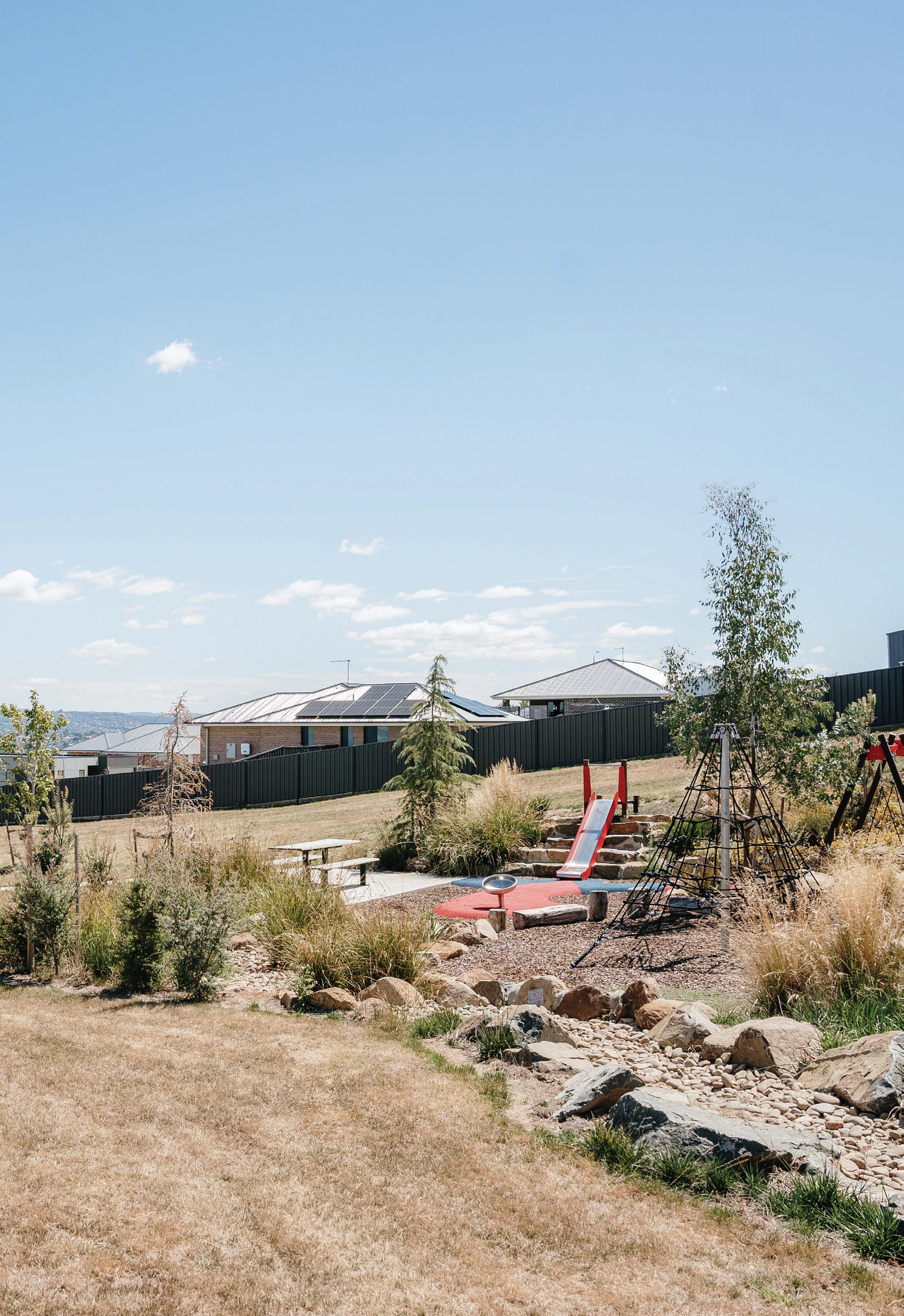
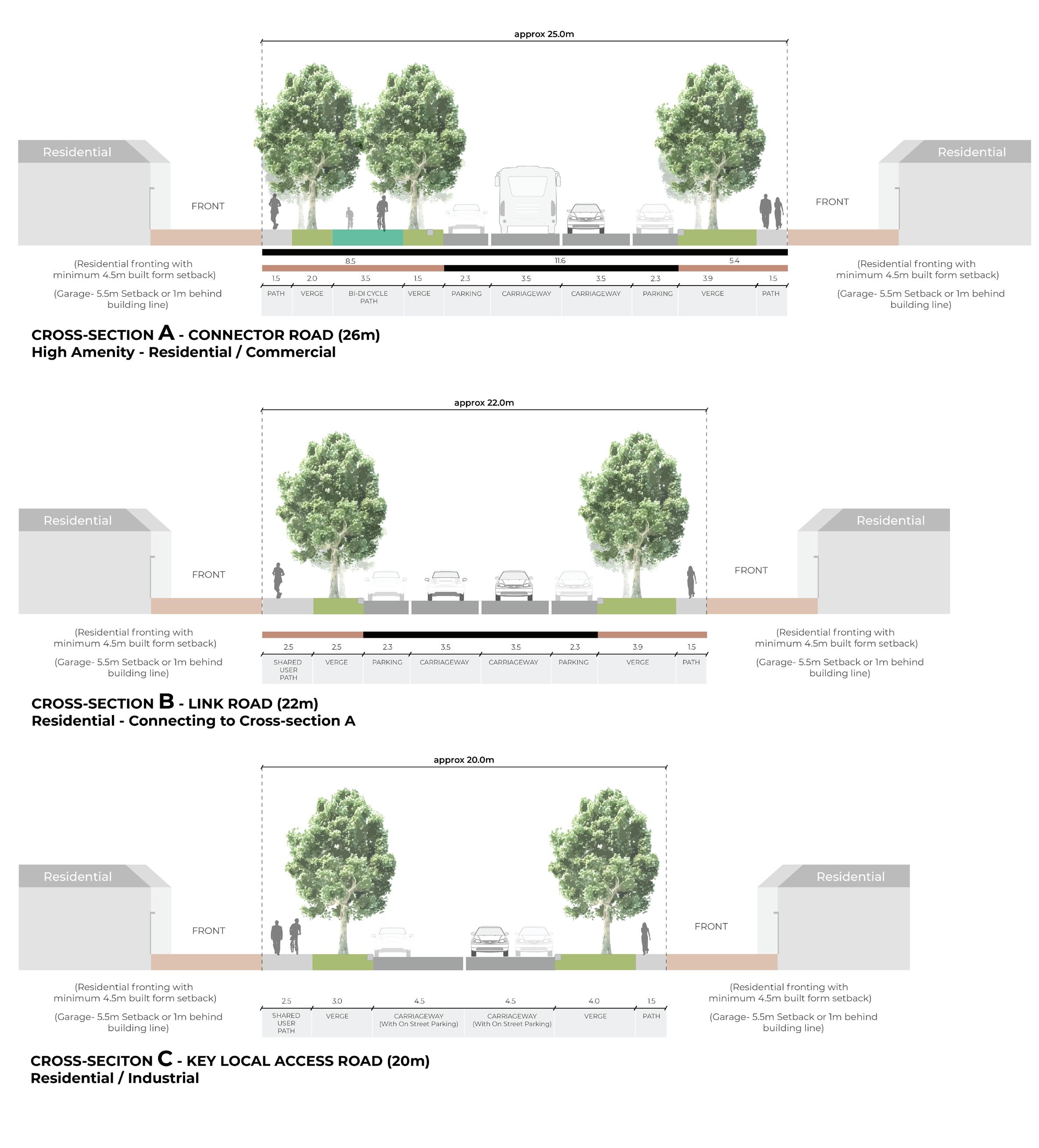
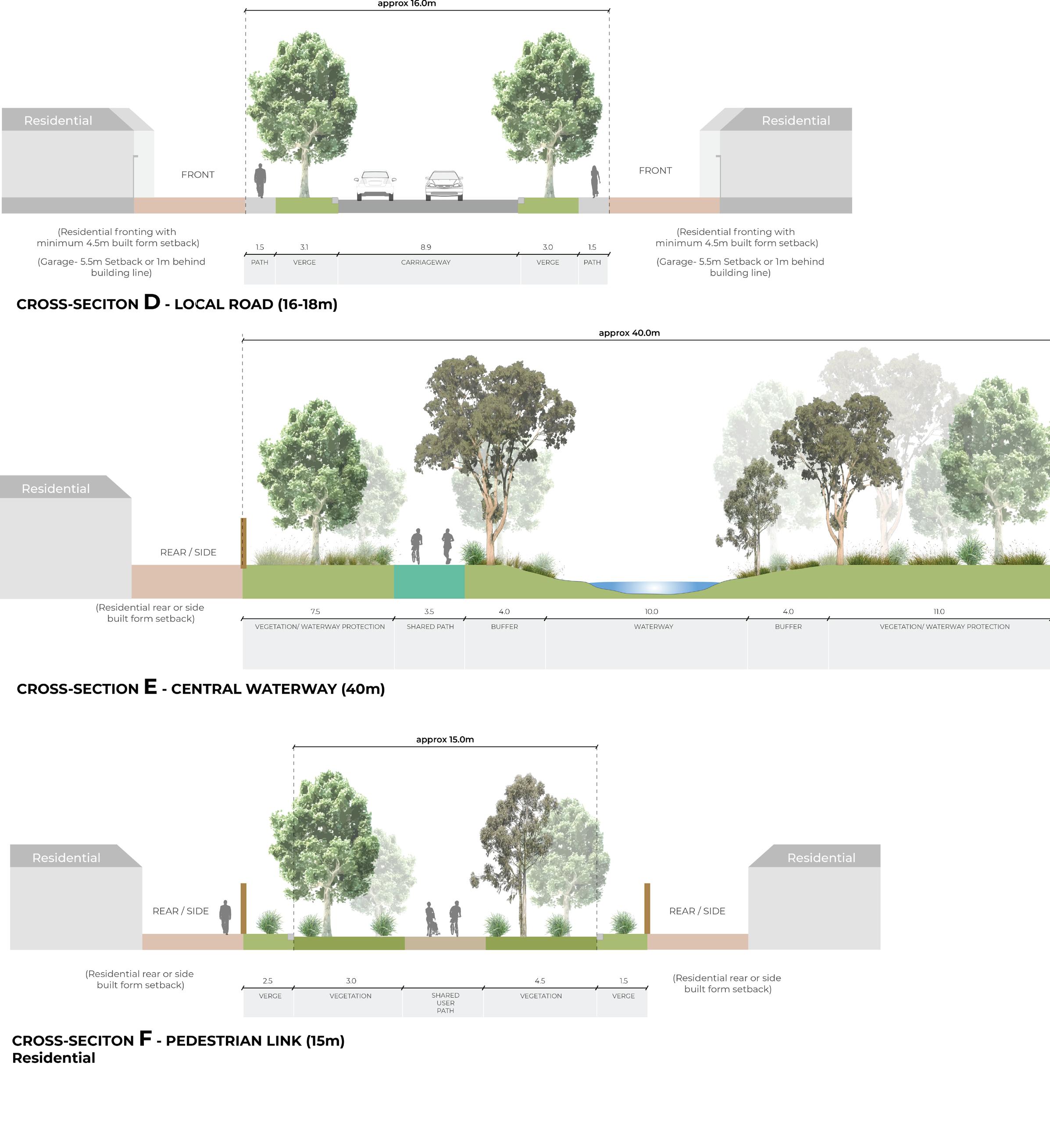
Refer to Strategic Direction 2, page 38 TRANSITION


SECTION PLAN - ABELS HILL RD SCALE 1:500


TRANSITION POINT 2


PROPOSED ROAD SECTION
SECTION PLAN - NORAH ST
SCALE 1:500
TRANSITION POINT 3
EXISTING SETTLEMENT
EXISTING SETTLEMENT
EXISTING ROAD SECTION
SECTION PLAN - CRAIG ST
SCALE 1:500


BIBRA PLACE RECREATION RESERVE APPROVED DEVELOPMENT
EXISTING ROAD SECTION


ROAD SECTION