1 minute read
CIRCULATION

19. CIRCULATION
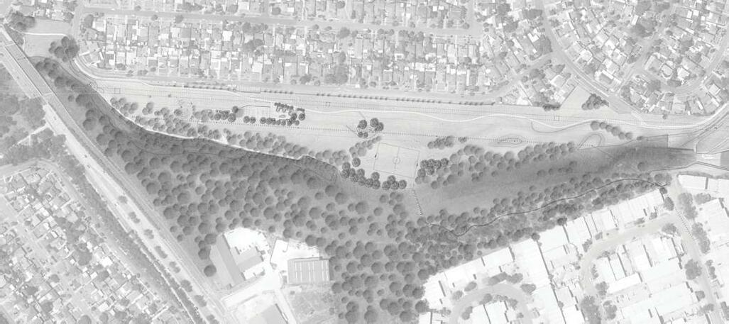
The existing circulation network within Sue Savage and Reynolds Parks is to be supplemented and improved with new path connections. The dominant connecting path is the existing 3m wide shared path linking Parramatta CBD with Toongabbie Station which is proposed to extend to Bankstown CBD in the future.
A network of small paths link the playground with the shared path and provide a small learn-to-ride loop for children. An informal bush trail currently runs behind the playground along the edge of the riparian vegetation, emerging onto turf towards the centre of the park. An informal wear path runs along the turf at the edge of the riparian corridor, providing a shaded walk for pedestrians.
PROPOSED
Two locations for bridge crossings were explored as part of the master plan design process although they were not considered to be viable given the engineering constraints.
TUCKS RD ALIGNMENT
The base of any bridge structure is required to be a minimum of 500mm above the 1:100 year flood level. The width of the Toongabbie Creek riparian corridor and flood extents would result in a bridge length of approximately 75m in this location, making the bridge financially unfeasible given the location and relative low demand.
MCCOY PARK BASIN CONNECTION
For the shared path to McCoy Park basin link, the bridge would require to link to the top of the basin structure. At this location, the top of basin level is approximately 3m higher than the existing shared path opposite, resulting in a visually obtrusive structure and potentially creating problems with the overhead high voltage electricity transmission easement.
LEGEND
SITE BOUNDARY LINE
BRIDGE OPTION 1 (NOT VIABLE) MCCORY PARK BASIN TO SHARED PATH
BRIDGE OPTION 2 (NOT VIABLE) TUCKS ROAD ALIGNMENT
EXISTING 3M WIDE SHARED PATH (LINKS TOONGABBIE STATION WITH PARRAMATTA CBD) EXISTING BUSH TRAIL RETAINED (INFORMAL PATH)
NEW BUSH TRAIL
NEW CREEK CROSSING (STEPPING STONES) ACCESSIBLE ONLY DURING LOW FLOWS
EXISTING WEAR PATH ALONG EDGE OF RIPARIAN CORRIDOR RETAINED (INFORMAL PATH) INSTALL TO FENCING TO ALLOW PATH ACCESS TO TUCKS ROAD OVER STORMWATER HEADWALL (ACCESSIBLE DURING FLOOD EVENTS)
JOHNSTONS T-WAY BUS INTERCHAGE
NEW PATH TO CONNECT EXISTING PLAYGROUND WITH NEW AMENITIES BUILDING, YOUTH PRECINCT AND NEW PARKING BAYS
EXISTING SPILLWAY RETAINED - NO CHANGES PROPOSED TO ACCESS DUE TO FLOOD/DROWNING RISK