11 minute read
Ballyvaughan


Ballyvaughan
Location and Context
Ballyvaughan is a picturesque village located on the shores of Ballyvaughan Bay and first established as a 19th century fishing village. It is situated at the base of a valley providing expansive views of the surrounding upland Burren areas and across Galway Bay. The village is an attractive, quaint place with an identifiable village centre focussed on existing shops, petrol station, church, school, pubs and enterprise units. The village also has a primary care centre, community centre and playground.
The town centre has a distinct character and has been designated as an Architectural Conservation Area (ACA). It comprises 18th and 19th century two-storey houses which accommodate a hotel, pubs, shops, and restaurants, all of which contribute positively to the attractive traditional appearance of the village. To the east of the village is the auxiliary workhouse, which is a mid-19th century residential complex laid out in a quadrangle surrounded by rows of terraced single-storey stone gabled houses. Although some of the original structures within the complex are derelict, many of the single-storey buildings have been restored and are currently in use. This site is also designated as an ACA due to its unique character.
Given its scenic coastal location on the Wild Atlantic Way and its position on the edge of the Burren, Ballyvaughan has become a popular destination for visitors. There has been considerable growth in the range of holiday accommodation on offer in the village, including hotels, bed and breakfasts, guesthouses, and holiday homes.
As with many coastal towns and villages, there is an influx of tourists during the main holiday periods which sees a significant increase in the population. There are also a number of local events and activities that bring visitors to the village during the off-peak season. These include the Burren Peaks Walking Festival and bird watching at Bishops Quarter. Ballyvaughan has experienced a significant amount of development pressure in recent years, primarily in the form of holiday home developments. It is therefore essential to ensure that future development is balanced and contributes to a thriving village community which can support a range of viable year-round services, whilst retaining its distinctive village character.
The strategy for Ballyvaughan is to provide for small scale, well-designed permanent residential, commercial and community developments that have regard to the character of the settlement.
Water supply to Ballyvaughan is from the Ennistymon Regional Water Supply and is subject to the constraints of that supply. The existing public wastewater infrastructure in the village consists of a collection system and tidal holding tank located in the foreshore area. A new wastewater treatment plant, pumping station including pipework extensions are planned and it is expected that the project will be completed in 2023. Once completed it will have capacity to cater for the target population over the lifetime of the plan.
__________________________________________________________________________________ Draft Clare County Development Plan 2023-2029
A ‘Regionally Important Aquifer’ is located in the area, with ‘Extreme’ and ‘High’ groundwater vulnerability ratings. Protection of groundwater is therefore an important issue and will need to be considered in any future development proposals in the village.
Ballyvaughan Bay area is designated as a Special Area of Conservation (SAC) through the Galway Bay Complex SAC and a Special Protection Area (SPA) through the Inner Galway Bay SPA. A number of other SACs are located surrounding the settlement including Ballyvaughan Turlough SAC, Moneen Mountain SAC and Black Head-Poulsallagh Complex SAC. These are all vulnerable to groundwater contamination in the absence of an adequate wastewater treatment plant.
Development proposals must ensure that there are no adverse effects on the conservation objectives of the SACs and SPA or on-site integrity, or the integrity of any European site as a result of the proposed development. Accordingly, objectives relating to European sites and to appropriate assessment in particular CDP Objective 3.1 will apply to any future development proposals in this area. The Natura Impact Report accompanying this plan (Volume 10a) provides relevant mitigation measures and recommendations at site and project level.
In addition, the ‘Ballyvaughan/Poulnaclough Bay Pollution Reduction Program’ produced by Clare County Council in compliance with the Quality of Shellfish Waters Regulations 2006, sets out a program for the designated shellfish growing waters of Ballyvaughan/Poulnaclough Bay. Where appropriate development applications should address the potential risk of the introduction and spread of invasive species such as Japanese knotweed and three cornered leek via movement into the area. Appropriate signage shall be erected notifying users of invasive species and facilities provided for users to clean equipment.
General Objective:
• To encourage future development that contributes to a thriving village community, which can support a range of services that are viable on a year-round basis, whilst retaining the distinctive village character and setting.
Employment and Enterprise
The main economic activities in Ballyvaughan are sustainable farming of the surrounding Burren landscape and tourism activity. This is further diversified by the presence of artisan food producers, artists and other craft activities. The continued development of existing tourism operations must be supported as well as new opportunities to grow the tourism industry in the village. Opportunities also exist for the development of other forms of enterprise in the area to ensure sustainable, year-round employment opportunities for the local community.
In order to promote economic development, it is an objective:
__________________________________________________________________________________ Draft Clare County Development Plan 2023-2029
• To support the continued development of existing tourism operations and facilitate the development of new tourism and leisure activities in Ballyvaughan, including the opportunities presented by its coastal location and for the development of ecological and marine-based tourism.
• To support the provision of a nursing home development in the Ballyvaughan area.
• To support the development of a footpath and cycleway along the N67 from Ballyvaughan to the Lisdoonvarna Road.
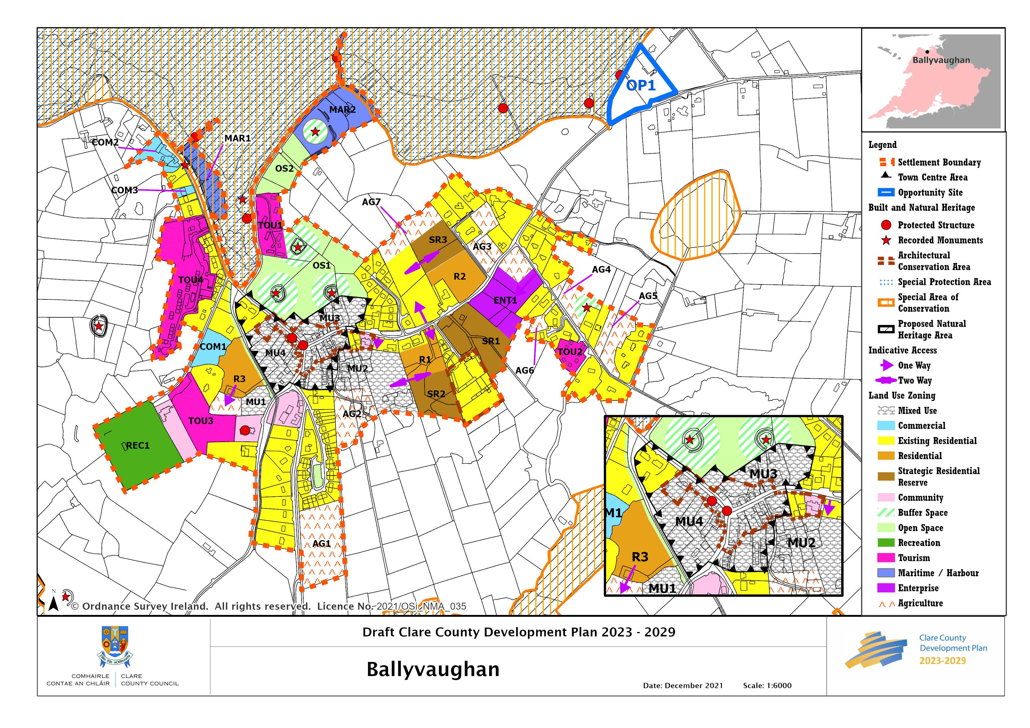
OP1 Former Culligan’s Visitor Centre/Burren House
This site is situated a short distance from the settlement boundary of Ballyvaughan on the N67. The existing building on site formerly accommodated a restaurant and gift shop. The site has an extensive parking area and commands stunning views of the bay. The redevelopment/reuse of this site would make a valuable contribution to the range of services and economic activities in Ballyvaughan. The provision of coach parking on site is a valuable asset and shall be retained in any redevelopment of the site.
MU1 Lisdoonvarna Road
This is a key site on the southern approach to the village (from Lisdoonvarna). It is located between a Protected Structure, St. John the Baptist Church (RPS 156), and the existing filling station and shop. There are attractive views from the site towards Gleninagh to the west.
The site is suitable for a range of uses that will enhance the level of services available to local residents and visitors to the area. While residential uses will be considered on the site, the use of these lands solely for the development of holiday homes is not acceptable.
The existing stone wall along the roadside boundary of the site creates a strong physical and visual connection between the church and the village core and plays a key role in creating definition along the road edge in this area. This wall shall be retained and integrated into any future development proposals on the site.
Given the location of the site directly in the line of vision on the southern approach to the village, development proposals must be of a high standard of design, reflecting the rural character of the area and complementing the neighbouring church.
COM 2 and COM 3 Commercial Lands
Given the location of these lands directly adjacent to the Inner Galway Bay SPA (004031), Galway Bay Complex SAC (000268) and the Galway Bay Complex NHA (000268) any future development, expansion or alteration of existing uses at these locations shall undertake screening for appropriate assessment. Ecological surveys to cover Otter species shall also be undertaken and shall inform any future development application.
__________________________________________________________________________________ Draft Clare County Development Plan 2023-2029
Housing and Sustainable Communities
While it is acknowledged that holiday homes are an essential component in providing a range of accommodation options for visitors, it is also important to provide for small scale, well designed residential development for permanent occupation. This will ensure that growth is balanced and contributes to a thriving village community which can support a range of services which are viable year-round, whilst retaining Ballyvaughan’s distinctive village character. it is important to provide supporting amenities and facilities that are accessible to all.
It is an objective:
• To provide for residential development that will facilitate an increase in permanent occupancy.
• To support the development of facilities, amenities and services in the village that will cater for the needs of a range of users including current and future residents and will contribute to the sustainable development of the village into the future.
R1 and MU2 South of Main Street
This site comprises an area of backland located off the N67 Main Street, bounded by existing town centre development to the north and existing residences to the east and west. The site area is accessed via an existing entrance from the N67, and an upgrade of this entrance will be required as part of future development proposals in order to provide vehicular access as well as footpaths and lighting within the scheme.
The site has the capacity to accommodate low density development providing dwellings for permanent occupancy. Proposals for development must incorporate high quality house design and layout.
The adjacent backlands to the west of the site are zoned Mixed Use, MU4, and offer an opportunity to provide an integrated mixed-use development in conjunction with R1 lands. Access to MU2 lands is constrained due to a restricted entrance between the community hall and an existing dwelling at the front of the site. Therefore, future access to the site may need to be provided from R1 lands. In this regard, an ‘indicative future access’ is identified on the accompanying settlement map and any future development on R1 lands will be required to provide/safeguard access to the western lands as part of any planning application.
R2 North of the N67
This site is located on the N67 to the east of the village centre. The lands are slightly elevated with distant views of the Burren to the south and west. Development proposals for these lands must retain the attractive stone wall which runs along the majority of the roadside boundary except where removal is required to provide safe access to the development. Future access to this site must be provided within the 50kph speed limit, as indicated on the accompanying settlement map.
__________________________________________________________________________________ Draft Clare County Development Plan 2023-2029
Strategic Residential Reserve (SRR)
Acknowledging that not all lands within the settlement boundary of Ballyvaughan will be required for development to 2029, lands which comprise infill or contiguous sites or have a planning history for residential use and can form part of the long-term sequential expansion of the settlement are zoned SRR. Consideration may be given to the development of some SRR lands before the end of the plan period, in line with provisions set out for Strategic Residential Reserve in Section 19.4 of Volume 1.
Transport, Active Travel and Connectivity
Bus Eireann provide a regular bus service to and from Ennis and Galway City and Local Link also provide services to Corofin and Ennistymon. These services provide a valuable connection to other service centres and an alternative to the private car and encourages a modal shift to a more sustainable transport option.
There is a public footpath in the village linking the village centre to the church and existing residences on St Joseph’s Road to the south, west along the coast road serving the pier and Monk’s Bar. The provision of a public footpath to serve existing residences and zoned lands to the east of the village is supported in the Plan.
Enhancement of and provision for green infrastructure such as walking and cycling routes would promote active recreation and sustainable travel in the town and its environs. There is a need for improved road safety features and parking in the village including additional footpaths, traffic calming measures and appropriate signage. The development of walking routes and trails within proximity to the village will significantly enhance the village amenities. The continued development of the Ballyvaughan Wood Loop is supported. This trail recently received funding under the Outdoor Recreation Infrastructure Scheme (ORIS) designed to support the further enhancement of recreational amenities such as mountain trails and forest walks, beaches, rivers, lakes, blueways and greenways.
Place Making and Regeneration
The sense of place in the village is very strong due to the location, the built and natural environment and the high standard of care and maintenance. While there are some vacant buildings in the village, they are generally reasonably well maintained. However, they may deteriorate over time therefore it is important to bring these buildings back into active use.
Ballyvaughan has a simple but attractive stone wall and grass verge boundary treatment. This has been lost in places where new development has occurred and been replaced by undefined setbacks. It is important to ensure future development in the village, particularly on the N67, retains the existing boundary treatment where possible by having suitably positioned access points off side roads.
It is an objective of the Council:
__________________________________________________________________________________ Draft Clare County Development Plan 2023-2029
• To promote sustainable and compact growth to address issues of vacancy. This includes the reuse or redevelopment of vacant, underutilised sites and buildings for alternative uses.
Flooding and Flood Risk
The Strategic Flood Risk Assessment in Volume 10(c) of this Plan shows flood risk is limited to existing development in Ballyvaughan. Given the history of flooding and known incidents of wave exacerbated storm damage, it is recommended that redevelopment of sites along the coastline are limited to less vulnerable uses, and sufficient measures are included in the design to ensure flood resilience.
__________________________________________________________________________________ Draft Clare County Development Plan 2023-2029