
APRIL - JUNE 2023 / VOLUME 4 INSIDE Plan to deliver record $210M Capital Works program 2023/2024 OPERATIONAL PLAN AND BUDGET FREE New online DA tracking tool Sport and recreation facility upgrades Road network improvements
MUCH MORE
AND
FROM THE MAYOR
Welcome to the fourth Clarence Magazine, which includes valuable information for the Clarence community on Council’s wide-ranging activities and projects. Please enjoy the read!
In recent years, as you all well know, bushfires, floods and the Covid pandemic have created significant challenges, to which our community has responded with unity and resilience.
I, and my councillor colleagues, are proud of the role Council has played in supporting the community recovery effort over the past year across all aspects of its core business, including society, infrastructure, economy, environment and leadership.
We have together addressed the massive task of repairing and replacing flood damaged infrastructure across the region, especially roads and bridges. New places have been created for locals and visitors to gather and enjoy. Work has been undertaken to make our communities safer and more connected. Events have been facilitated to show that despite recent challenges we still know how to have a good time.
Despite what we have achieved so far, there is still so much more to do. The 2022/2023
Operational Plan and Budget identifies Council’s plans for the coming year, and features a record $210M capital works infrastructure program. Continuing to revitalise and improve our floodravaged transport network will be a major focus. There are also plans for several exciting new community facilities across the Valley.
To achieve our aspirations for the community, Council will be working closely with State and Federal levels of government, given our reliance on their support to fund many significant projects.


Clarence Magazine will continue to be part of Council’s commitment to increase its communication of important information to community. Council is committed to keeping you abreast of progress on major projects and initiatives. Welcome to Volume 4 and please enjoy the read.
Ian Tiley
Cr Ian Tiley, Mayor

PICTURED: Mayor Ian Tiley pictured in March with the former Member for Clarence Chris Gulaptis and new Member for Clarence Richie Williamson at the $10 million funding announcement to improve flood immunity on Yamba Road.
We acknowledge the Bundjalung, Gumbaynggirr and Yaegl people as the Traditional Owners of the land on which we live and work. We honour the First Nations peoples culture and connection to land, sea and community. We pay our respects to their Elders past, present and emerging.

FROM THE MAYOR 2
WELCOME
Front cover image: Iluka Break Wall is a popular location amongst locals and visitors alike.


CONTENTS 3 38 10 20 CLARENCE Magazine Volume 4 is packed full of stories from the Clarence Valley, showcasing the five pillars of our Community Strategic Plan: Infrastructure, Society, Economy, Environment and Leadership Open the camera app on your device and point it at the QR code 1 Wait for camera to recognise and scan QR code 2 Click banner or notification when it appears on your screen
Information associated with the QR code will appear on screen 4 To view Clarence Magazine online scan this QR code HOW TO USE A QR CODE Welcome from the General Manager 4 Clarence Magazine survey 5 Infrastructure Roads Policy update 6 Road infrastructure projects 8 Bridge infrastructure updates 10 School zone safety / speed zone management 13 Solar lighting in public spaces 14 Shared user pathway extensions 15 Ulmarra village revitalised 16 Grafton Riverfront Precinct project 17 Sport and recreation facility upgrades 18 Wherrett Park, Maclean upgrade 20 Sewer network investments 22 Stormwater drainage project / levee rehabilitation 24 Water quality improvements 25 Bushfire management 26 Society Simtables for Community Empowerment / Resilient Clarence Digital Map 27 Responsible pet ownership 30 Feral cat management 31 Events and sporting grants funding 36 Youth Week events 37 Improving Country Halls / ANZAC Day at Tullymorgan hall 39 Economy Improving Development Application processes 34 Environment Weeds management 28 Protecting a national icon 29 Grafton Regional Landfill upgrade 32 Bulky Waste Collection Service 33 Leadership Community Engagement Sessions 38 Operational Plan 2023/2024 40
3
FROM THE GENERAL MANAGER
Welcome to Volume Four of the Clarence magazine. This volume brings reporting on our Operational Plan for 2022/2023 to a close, so we’re keen to hear your views to provide some direction for future volumes. We’ve kept cost down by delivering the magazine in house and through local printers, but we’d like to know if you agree with the quality and the way we explain what we’ve done. Please help us out by completing the survey.
This issue rounds out what we’ve achieved during the year. We start though with an explanation of road maintenance and the quantum of heavy patching and pothole repair undertaken. You’ll be pleased to know the significant amount of work on the road network over the past 12 months is paying off with far fewer defects being recorded. Some of the major works in this volume are the widening of Brooms Head Road to improve safety, a great outcome on a difficult stretch of River Street in Maclean that is prone to destabilisation due to its low level behind the levee wall, and the engineering feat of the Coutts Crossing Bridges providing vital connection to Grafton during disasters. There are another 11 bridges, including Wilcox Bridge which was swept away in the March 2022 event, under construction.
We continued our school safety upgrades at several locations, bringing much of that State Government funded program to an end, and in partnership with Transport NSW delivered town entrance speed zone safety initiatives.
Walkers and cyclists in Yamba can enjoy extended walking hours during winter with new solar lighting along the foreshore in Ford Park, with light intensity increasing when motion is detected.
Ulmarra is looking fantastic with new road pavement, improved parking, pedestrian links, landscaping and playground. If you haven’t dropped by lately, you really must take a look. The long-awaited Grafton Waterfront will open soon and it too is looking like a great place to wander, meet and spend time.
Basketball, netball and tennis recreational facilities across the region have had facelifts recently and there’s plenty happening in the delivery of play spaces too, with Wherrett Park Maclean opened most recently. We’ll be interested to hear how popular the first hamster wheel in the Clarence Valley is to determine if becomes a more common feature in our upgrades.
Following the 2022 storm and flood event, upgrading pumps has become more of a priority, with improvements to pump capacity at Wherrett Park and Essex Drain in Maclean, which are both vital pumps to lower ponding water. Bacon Street Grafton also received a new pump to prevent ponding.
After CCTV inspections of infrastructure, relining sewer pipes in Maclean and Yamba to extend the lifespan to 100 years commenced. Did you know we are now able to perform real time monitoring of sewage treatment plants and pump stations to mitigate risk of environmental damage? This is another example of using technology to improve our efficiency, as we no longer need to be at every site to collect data.
Since the boil water alert in January, a new clarifying lagoon has been constructed at Rushforth Road Water Treatment Plant to improve water quality and safeguard against dirty water events until such time as water filtration is decided. Construction of the lagoon significantly reduces reliance on Coffs Harbour when turbidity levels in the Nymboida are too high to draw water.
Long awaited updates to the online DA tracking tool are now live, with additional documentation now available for DAs lodged since January 2023.
The Resilient Clarence digital map was launched and can be viewed online, telling the stories of communities and residents affected by the 2019/2020 bushfires – if you intend to watch them be prepared for laughter and tears. Youth Week was a major success, and support was provided for delivery of many local events. All in all, it’s been an incredibly busy quarter.
Laura Black, General Manager

WELCOME 4
Laura Black
SHARE YOUR FEEDBACK
In June each year, Council adopts its budget and Operational Plan for the following financial year. Clarence Magazine was introduced in 2022/2023 for the purpose of informing residents about what Council is delivering with ratings income and grant funds and how it is achieving the actions that it planned to deliver. We design and produce in-house and print locally to keep our costs low, enabling us to give the reader a high quality product. The magazine is produced quarterly because we plan our activities in quarters. At the end of each quarter, Clarence Magazine tells the story of what was achieved in the previous quarter.
We are interested in your feedback. You can complete the survey online by scanning the QR code on this page and signing up to Clarence Conversations or complete the following form and drop it into our Customer Service Centre at 2 Prince Street, Grafton or 50 River Street, Maclean. Survey closes 30 September, 2023. scan me
Clarence Magazine is a magazine for Clarence Valley residents and to make sure it's the best magazine possible, feedback is needed from you, the readers. Thank you for your time filling out this survey. Please circle Yes or No ( Y / N ) and provide feedback in 25 words or less.
1. Tell us about yourself: Age: Gender: What is the name of the suburb you live in?
2. Where have you seen a printed hardcopy of Clarence Magazine?
Gallery
Library
Council
Holiday Park
Other (please specify):
3. In what format do you prefer to read Clarence Magazine?
Printed hardcopy of the magazine
Online (on-screen: computer/mobile/tablet)
4. How do you prefer to access Clarence Magazine online?
Noticeboard
Website
Facebook
QR Code

Is the printed hardcopy version of the Clarence magazine of a quality you would expect (if your answer is no, please provide feedback)? Y / N
7. Do you feel more informed about what Council is doing with rates and grant funding after reading Clarence magazine? Y / N
8. Considering the purpose of the Clarence magazine, is there something else you think we should be including (if your answer is yes, please provide feedback)? Y / N
9. Would you recommend Clarence magazine to other residents? Y / N
5 SURVEY
ROADS POLICY UPDATE
MANAGING THE 2,475KM ROAD NETWORK

PRIORITISING REPAIRS
repair works to be carried out. Considerations when prioritising pothole and minor pavement failure repairs include:

An updated Roads Policy was adopted at the Ordinary Council Meeting on 27 June. The 2019 version of the policy was reviewed before going on public exhibition for six weeks in April. The primary purpose of the policy is to outline the level of service and response to the full scope of road related issues. It is based on a risk management approach to provide a systematic method of identification, evaluation and prioritisation of maintenance works on the roads and bridge network that will assist decision-making processes. Roads are inspected regularly in accordance with their classification rating, as well as in response to service requests from road users or Councillors, and service reports from employees.
The purpose of these inspections is to identify the location and severity of defects, level of work required, and generating a rank order for
n Road classification
n Defect severity
n Workforce workload
n Climatic conditions
n Available funding
ROAD HIERARCHY
All sealed and unsealed urban and rural roads receive a classification rating which is factored alongside traffic volume, road function and whether it is a bus route to determine the level of service provided. This includes inspection frequency, treatment options, and repair priorities of potential hazards to road users.
The frequency that each road is inspected is determined by its classification rating. State highways receive the highest rating (5), while urban streets with less than 200 vehicle movements per day (vpd) and rural roads with less than 100vpd receive the lowest rating (1).
6 INFRASTRUCTURE
PICTURED: As a regional road, Clarence Way has a Road Hierarchy rating of 4.
HEAVY PATCHING
Heavy patching completed on Local and Regional roads in the Clarence Valley LGA. For much of the period from January to June 2022 conditions sub-surface conditions were too wet for effective heavy patching.
HEAVY PATCHING COMPLETED (M2):

PICTURED: Left; although a major hazard, this large pothole located in a low traffic volume section of Pound Street in Grafton with alternative routes available was closed for a period of about two months while other higher priority repairs were carried out in the immediate aftermath of the 2022 floods. Far left; pothole patching on the Gwydir Highway is generally of high priority given its maximum classification rating as a State highway.
POTHOLE REPAIRS
Pothole repairs completed versus new potholes recorded. Natural disasters in 2021 and 2022 resulted in more potholes. In the past six months the backlog has been reduced with relatively few potholes recorded and a high number of repairs completed.

NUMBER OF POTHOLES REPAIRED:
AN OVERALL ROAD RISK RATING IS DETERMINED FOR EACH DEFECT BY INSERTING SCORES INTO THE FOLLOWING EQUATION:
( ROAD RISK RATING = LOCATION + (ROAD HIERARCHY X2) + HAZARD + ROAD USAGE )
THE ROAD RISK RATING EQUATION SCORES EXPLAINED:
ROAD HIERARCHY: Scores between 1 and 5 are allocated according to factors described on opposite page.
HAZARD: Scores between 1 and 5 are allocated according to hazard type and severity in terms of size. Types of road surface hazards include potholes, shoving, rutting, edge drops, objects and spills.
ROAD USAGE: Add 1 if the road is a bus route.
7 INFRASTRUCTURE
RISK RATING PRIORITY ACTION 4 or less No Activity No action required - monitor.
- 6 Low Programmed into maintenance works. 7 - 10 Medium Programmed into maintenance works.
13 High Inspect and make safe
24
Urgent Inspect
DATES LOCAL REGIONAL Jun-Dec 2021 35,642 m2 26,984 m2 Jan-Jun 2022 5,261 m2 7,285 m2 Jul-Dec 2022 44,210 m2 41,550 m2 Jan-Jun 2023* 88,544 m2 8,950 m2 DATES RECORDED COMPLETED Jun-Dec 2021 26,376 13,919 Jan-Jun 2022 17,134 11,241 Jul-Dec 2022 18,907 16,527 Jan-Jun 2023* 10,372 16,369
5
11 -
within
hours. Effect repair within 3 working days. 14 - 21
and make safe within 4 hours. Effect repair within 24 hours.
As at 07 June 2023
*
LOCATION: 1 – road
or median 2 – shoulder 3 – parking lane 4 – traffic lane 5 – total
reserve
carriageway
THE PROCESS
1
WIDENING OF BROOMS HEAD ROAD
Safer drive to seaside village
A 2km stretch of Brooms Head Road has been significantly widened to improve safety.

Each side of the road along the improved section has now been widened by 1.5m to create a shoulder and extend each lane from around 3m in width to 4.4m.
4000
TONNES OF GRAVEL
The changes improve road safety, especially for wide loads such as caravans or trucks. The road is a busy thoroughfare, particularly with tourists during school holidays.
Five local contractors were utilised to complete the $350,000 project in a period of just over two weeks in May.

2
Grader shaves off 150-200mm of material, 1.5m wide on each side of road
The ShoulderMaster paving attachment lays down DGB20 gravel with 1% concrete mix
3
Gravel compacted using smooth drum roller using both vibrate and static techniques
4
Grader follows behind roller to trim to height, leaving material slightly high to allow for traffic compaction and final trimming after material sets
5
On sealing day, grader trims shoulder to correct height, shapes hinge point. Roller follows with static roll
6
Sealing truck lays emulsion and 7-10mm pre-coat stone blend for sealing with two coats
7
PICTURED: Top, specialised machinery was used to optimise efficiency. Above left, tonnes of materials were used in the widening of Brooms Head Road. Above right, The finished product with the road significantly widened to improve safety.
8
Once stone sets, another static roll between coats
Sweeper truck sweeps road to remove loose stone

8 INFRASTRUCTURE
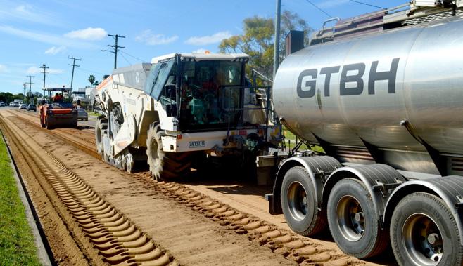
NEW TECH MEETS ENGINEERING CHALLENGES
Efficient rehabilitation of Maclean’s main road
13,000m2
TOTAL ROAD SURFACE REHABILITATED
1. A layer of gravel is spread evenly over the road surface. 2. The road is premilled. 3. The road is stabilised with bitumen and lime, and rolled and compacted. 4. A bitumen spray seal is applied.
FOAMED BITUMEN STABILISATION
1
Thin layer of gravel spread over existing pavement and top 200-250mm premilled and mixed by road reclaimer/ stabiliser.
2
New road stabilisation and revitalisation technology has helped give River Street Maclean a new lease on life.

A 1.1km stretch of Maclean’s main street from Union Street to Hogues Lane has been renewed. The innovative technique known as ‘foamed bitumen stabilisation’ was used to minimise cost and construction time, and maximise durability.
The $1.1 million project was funded by NSW Government regional roads grants and took around three weeks to complete, minimising ratepayers costs

WHAT NOW FOR RIVER STREET?
and traffic disruptions.
The road posed several challenges that made conventional construction methods unviable: n Resealing over the top was considered inadequate and would have had a short lifespan; n Reconstruction would have been hampered by subsurface water as the road is below the level of the nearby Clarence River.
The foam bitumen process addresses both challenges by creating a highly durable pavement without the need for excavation.
Now rehabilitation of this section of River Street is complete, attention will turn to pedestrian safety. Traffic calming measures are under development, including safe crossing points and specialised speed zone signage at each entry point to Maclean.
3
Blend of cement and lime spread lightly over gravel layer and mixed by road reclaimer.
Layer mixed again with inclusion of hot bitumen and water to create foaming bitumen, which is blended with the gravel to act as the binder.
4
New pavement compacted using rollers and trimmed with grader to its final level.

5
Initial spray seal applied and road opened to traffic. Road is allowed to ‘cure’ for three months before final bitumen spray seal.
9 INFRASTRUCTURE
1 3 2
4
COUTTS BRIDGES NOW OPEN
$6.5M for two new concrete crossings
The $6.5 million project to replace two ageing timber bridges on the Armidale Road immediately north of Coutts Crossing village is complete. It was funded by the NSW Government’s Fixing Country Bridges Program.

The location is flood prone, and the new bridges will provide a more flood resilient connection to Grafton.
The concrete bridges also require far less maintenance
and have an anticipated lifespan of about 100 years.
The new bridges will be of great benefit to the community as they provide a vital link for residents, and a better run to Grafton and improve evacuation options during disasters.
Fixing Country Bridges is an important program for the Clarence because of the extensive network of timber bridges, many of which are reaching the end of their lifespan.
BLUFF BRIDGE REPAIRS UNDERWAY
Work started in July to replace Bluff Bridge on Orara Way thanks to an $11.29 million grant under the NSW Government Fixing Country Bridges program.
Replacement of the deteriorating timber bridge will provide improved flood and fire immunity and reduce maintenance and inspection costs.
Initial works at the site will include
aerial surveys, geotechnical drilling and a flood study to help determine the deck level of the new bridge.
A contract for detailed design and construction of the new bridge is expected to be awarded in the second half of 2023, and construction will commence in 2024.
The existing bridge will remain open to traffic during construction.
STEP BY STEP PROCESS
10 INFRASTRUCTURE
Construct sidetrack; divert traffic 1 Demolish existing timber bridges 2 Excavate old abutments 3 Drive precast concrete piles 4 Construct onsite reinforced concrete abutments and headstocks 5 Install precast concrete beams 6 Form and pour reinforced concrete deck slab 7 Install bridge barriers 8 Construct approach pavements and bitumen seal
Install guardrail and line marking 10 Open to traffic 11
9
INFRASTRUCTURE
WHAT’S IN A BRIDGE
TOTAL MATERIAL VOLUMES FOR COUTTS BRIDGES 1 AND 2:
385m3
ONSITE CONCRETE
370m3
PRECAST CONCRETE
480m3
SCOUR ROCK
$46M
FIXING COUNTRY BRIDGES PROGRAM: IN FUNDING SECURED

36 BRIDGES TO BE REPLACED BY END OF 2025
800m3
APPROACH PAVEMENT GRAVEL
1400m2
BITUMEN SEAL

UP TO DATE ON BRIDGE WORKS WITH VIRTUAL MAP
STAY
GREEN: Completed and open to traffic
AMBER: Works in progress
RED: Design phase/construction not started.
Scan the QR code for more details and to track the latest progress updates


UNDER CONSTRUCTION
n Barretts Creek Bridge, Coaldale Road, Barretts Creek
n Winters Bridge, Jackadgery-Lilydale Road, Lilydale
n Koukandowie No 2 Bridge and Skinners Swamp Bridge, Armidale Road south of Coutts Crossing
n Dundoo Floodway Bridge, Kungala Road, Halfway Creek
n Billys Creek Bridge, Armidale Rd, Dundurrabin
n Wintervale Bridge, Old Glen Innes Road, Dalmorton
n Fortis Creek Bridge, Greberts Road, Whiteman Creek
n White Swamp Bridge, Stockyard Creek Road, Stockyard Creek
n Minnie Waters Bridge No.2, Sandon Road, Minnie Water
n Sweeneys Creek Bridge, Sweeneys Creek Road, Ulmarra
STAY UP-TO-DATE ON ROAD REPAIRS
Sign up to Council's weekly newsletter, Noticeboard, for up-todate information about road maintenance activities throughout the Clarence Valley. A Schedule of Works is included in the newsletter and outlines all current road maintenance activities including flood damage repairs, bridge construction, heavy patching, resurfacing and resealing, boat ramp works and road grading. To receive the emailed newsletter, scan the QR code or go to www.clarence.nsw.gov.au/Noticeboard

11
PICTURED: Two newly completed bridges on Armidale Road, Coutts Crossing, provide a vital link for residents.
BRIDGE REPLACEMENT UNDERWAY
Project funded by disaster recovery program
Construction of the new Wilcox Bridge at Swan Creek has commenced.
The concrete bridge on Four Mile Lane was destroyed in the February 2022 floods. Crews have completed demolition of the damaged bridge and removal of debris from the site.

The new bridge is anticipated to be completed by the end of 2023.
The $3.2 million cost to demolish and replace the bridge is being funded by the joint State and Federal Disaster Recovery Funding Arrangements (DRFA). It is part of a series of current DRFA funded Essential Public Asset Restoration (EPAR) projects set to be completed with a total strategic estimate of $86.1 million (see table).
ESSENTIAL PUBLIC ASSET RESTORATION PROJECT PROGRESS
12
PICTURED: The new Wilcox Bridge at Swan Creek is under construction.
Project Status Value 6 Mile Lane bridge approach Pre-construction planning $600,000 Armidale Road drainage Construction commencing in July $3,600,000 Wilcox Bridge Under Construction $3,700,000 Local Roads Sealed Pavement Works Being assessed for eligibility $34,000,000 Regional roads sealed pavement works Construction commencing in July $16,477,652 Project Development On going $1,800,000 Pateman's Road drainage 80% design $600,000 Armidale Road headwall ext. Under construction $468,000 Frames Bridge 30% design $1,200,000 Gorge Road causeway Investigations and concept design $750,000 Tallawudjah Creek culverts Pre-construction planning $1,000,000 Lawrence Road Alumy Creek 30% design $1,000,000 Sandy Crossing Wooli Being assessed for eligibility $750,000 Great Marlow Road Pre-construction planning $500,000 Marine Parade Yamba 80% design $1,000,000 Clarence Way Landslips Pre-construction planning $1,750,000 Kangaroo Creek Landslip Being assessed for eligibility $975,000 Old Glen Innes Road landslips Being assessed for eligibility $9,000,000 Tallawudjah Creek waterway Design work commenced $4,000,000 Sandy Swamp causeway Investigations and development of concept design $1,500,000 Culvert Repair Package Being assessed for eligibility $1,000,000 Whiteman Creek Causeway Repair Being assessed for eligibility $450,000 Total Strategic Estimate $86,120,652
SCHOOL SAFETY UPGRADES COMPLETE
Massive program benefits 18 schools
VILLAGE ENTRIES MADE SAFER
The entry points to Glenreagh and Townsend villages have been made safer using specialised speed zone signage.

Light-up vehicle activated signs have been placed at the southbound entry points of each village. The signs detect a vehicle’s speed and light up if the speed limit is exceeded, clearly alerting speeding motorists to the reduction of speed limit to 50km/h and urging them to slow down. High visibility road stencilling has also been used at each entry point to Glenreagh to highlight the change in speed zones.
School zone safety improvements have now been completed at 18 schools, marking completion of the State and Federal funded School Zone Infrastructure Program.

A range of safety and traffic calming measures were undertaken to improve pedestrian safety in school zones in Maclean, Grafton, South Grafton,

LATEST ADDITIONS
Harwood, Lawrence, Cowper, Palmers Island, Yamba and Iluka. Measures included wombat crossings, blister islands, pedestrian crossings, bus zone and crossing relocation, fencing, and footpaths.
A further school zone safety project at Coutts Crossing is planned for the coming year.
n Maclean Public Stage 2: Upgraded pedestrian crossing and new footpath
n South Grafton Infants School: Bus zone relocation, upgraded crossing points and new accessible parking space
n Palmers Island: New crossing point and footpath
n Grafton Public schools (Stage 2 - Bacon Street): Children crossing relocated to a safer location
n Gillwinga / St Josephs South Grafton (Stage 2): Pedestrian fencing and safe crossing point
13 INFRASTRUCTURE
PICTURED: The new wombat crossing on Mary Street at Grafton High School.
PICTURED: From top; lightup vehicle activated sign at Townsend; high visibility road stencilling at the entrance to Glenreagh.
NEW SOLAR LIGHTING FOR FORD PARK
Smart technology improves energy efficiency
Users of the Ford Park footpath at Yamba can now benefit from new and improved lighting.

Twelve LED solar-powered pole lights have replaced nine outdated lights along the shared path from Yamba Marina to Calypso Caravan Park, at a total cost of approximately $52,000.
The upgraded lighting system was funded through Council’s Open Spaces capital fund.
The lights are fitted with sensors that increase the lighting intensity as people approach. These will give approximately 32 watts of constant lighting along the walkway and increase to 55 watts when the sensors are activated.
The completed work, planned for in the 2022/2023 Operational Plan, followed community feedback from path users who asked for improved visibility for exercise during evenings and early mornings.
The Ford Park path is also popular with visitors who flock to the seaside village during school holidays.
32W55W
POWER OUTPUT INCREASES TO BRIGHTEN AREA WHEN MOVEMENT DETECTED
15m
DISTANCE SENSORS DETECT MOVEMENT
LIGHTING INTENSITY INCREASES WHEN THE SENSOR DETECTS MOVEMENT
14 INFRASTRUCTURE
PICTURED: New solar LED lights installed along the Ford Park footpath have improved conditions for early morning and evening users.
PIR* No.1 (L) Detection Zone Up to 15m/49º Up to 15m/49º
PIR* No.2 (R) Detection Zone
infrared sensor detection zone 6m
*Passive
IMPROVED PATHWAY LINKS


$1M TO EXTEND BENT ST
A new million-dollar footpath along upper Bent Street in South Grafton has been made possible by approval of a NSW Government grant.

The proposed 1.45km section connecting Tyson Street to Bush Drive has attracted $1.164 million through the 2023/2024 NSW


Active Grant program. The footpath extension will fill a major gap in the South Grafton pedestrian network and provides a connection between five schools. The next step of the project will be completing detailed designs, with construction expected to start in early 2024.
FINAL TOUCHES ON MACLEAN PATHWAY
The final touches have been applied to the new 480m section of shared user path along Cameron Street Maclean, including pavement stencils and a handrail.

Design of further sections is underway, as part of an overall project to complete a pedestrian and cycling link from Gulmarrad into Maclean, funded by the NSW Public Open Spaces Legacy Program
The project is part of a wider strategy to improve linkages between centres throughout the area, which will be updated under the Active Transport Strategy currently in development and due to be on public exhibition in the coming months.
The strategy aims to promote walking, cycling and other sustainable modes of active transport for short trip destinations, and contribute to improving equity, health and the environment.
PICTURED: Main image, a handrail has been installed on the new section of the Cameron Street path. Above; on-road stencilling alerts motorists to pedestrians.
Scan the QR code to watch a drone flyover of the new section of path


 PICTURED: Planning is underway to fill a vital missing link in South Grafton’s pedestrian network.
15 INFRASTRUCTURE
ULMARRA TRANSFORMED
CBD revamp enhances visitor experience
The heart of Ulmarra has been rejuvenated to create an improved experience for people enjoying what the village has to offer.
New roads, pavements, landscaping, extensive drainage works, parkland facilities and play areas have transformed the streetscape of the riverside central business district.
The changes are designed to attract
visitors to the village and create a major boost to local businesses.
The CBD will also be more resilient to flooding in high rainfall events, with installation of a new stormwater system, curb and guttering, and refined road design.

Footpaths have been widened, shade trees planted, and road safety measures put in place to enhance the
pedestrian experience.
Bailey Park has been redeveloped to include new barbecue and picnic facilities. It features a new playground and play equipment as well as a water play area.


The works were funded by the Australian and NSW Governments in association with Clarence Valley Council.
PICTURED: Clockwise from left; Bailey Park Ulmarra has been redeveloped, including extensive landscaping, community facilities and play areas; Coldstream Street’s makeover includes wider new footpaths, paving, new road surface and landscaping.
16 INFRASTRUCTURE
RIVERBANK BROUGHT TO LIFE
Finishing touches on Grafton Waterfront Precinct
The Grafton Waterfront Precinct project has transformed the underutilised riverbank into a family-friendly hub for locals and visitors.
The enhanced riverfront parklands on the north bank of the Clarence River features paved plaza areas and new community facilities, a 700m long, 3m wide shared user path, extensive landscaping, lighting, increased opportunities for river-based activities and improved access via adjoining streets.


The precinct is a flagship project within the Clarence River Way Masterplan, which aims to reinvent the Clarence as “one of the nation’s great river experiences” and redefine Grafton as a river city. The plan identified that few visitors
to Grafton were aware of its prime waterfront address and the river experience was poorly capitalised upon by the local community.
Clarence Valley Council General Manager Laura Black said it was exciting to see the $6.5 million Federal Government funded project come to life, as it had been in planning for more than two decades.
“It’s wonderful to see extensive works on the ground, after years of preparation and planning,” Ms Black said.
“We will now see locals and visitors flocking to enjoy this amazing new development, that capitalises on one of our greatest natural assets – the mighty Clarence River.”
FLOOD ART TO CAPTURE LOCAL EXPERIENCES
Flooding can mean devastating loss and ongoing hardship. But it can also be a time when communities demonstrate a spirit of enormous resilience and unity.
To mark the significance of the 2022 floods for the region, local artists were commissioned to create a series of public artworks. The $100,000 project was funded by the NSW Government through the Northern Rivers Joint Organisation.
The artworks will be displayed at several locations including the pylons of Harwood Bridge, the Lawrence water tower, and planter boxes in Prince Street, Grafton.

17 INFRASTRUCTURE
PICTURED: From top; seating and lighting has been installed along the shared user path to encourage people to utilise the landscaped waterfront; viewing platform over the river.
PICTURED: Part of the The Weathered Warriors artwork, by Jenna Rendell, is one of the artworks that will be displayed.
BOUNCING BACK IN SOUTH GRAFTON
Replaced basketball courts proving to be popular
The Beats, BBQ and Basketball event in Youth Week provided a successful first test for the refurbished JJ Lawrence Field Basketball Court in South Grafton.

The event in April attracted dozens of community members keen to participate in skills, drills and fames on the courts, while songwriting workshops, a free barbecue and plenty of other fun interactive activities run by local services took place on the periphery.
The new basketball court, multipurpose court and supporting infrastructure was constructed thanks to a $200,000 grant under the NSW Government's Stronger Country Communities Fund.
PICTURED, from top: Mayor Ian Tiley officially opened the JJ Lawrence Field Basketball Court. Community members tested out the revamped basketball facilities during Youth Week in April.
TENNIS COURTS REFURBISHED
Two tennis court complexes have a new lease on life after recent refurbishments.
The Junction Hill court renewal was joint funded by the Junction Hill Tennis Club, Clarence Valley Council and Tennis Australia.
The Braylesford Park court renewal in South Grafton was joint funded by South Grafton High School P&C, Clarence Valley Council and the NSW Government.

PICTURED: The Junction Hill tennis court renewal was officially opened on 2 June.

18 INFRASTRUCTURE
NETBALL SCORES $1.2M UPGRADE
New courts and lighting boost local sport
Hundreds of netballers are now enjoying top-notch new facilities, thanks to a $1.2 million upgrade to Grafton’s Westward Park.
The eight new concrete courts and upgraded LED lighting were completed in time for the start of the winter netball season, much to the excitement of Grafton Netball Association President Brooke Burton.

“The old courts were at the end of their life – it’s amazing to see the transformation from what it was to what it is now,” Ms Burton said.
“Having all the courts lit, we now have the option of a night competition, it increases the opportunities for training … it really opens the door to bigger
and better things.”
The new facility also offers greatly improved safety and accessibility for players and spectators.
Among backers of the project was Grafton product and Australian Diamonds Netball Squad player, Verity Charles, who provided a passionate letter of support for the funding application. Verity grew up playing on the Bacon Street courts, progressing to the National Super Netball League’s West Coast Fever.
The new facilities were funded by a $947,400 NSW Regional Sports Facility Fund grant, $210,000 from Council, and $40,000 from the Grafton Netball Association.
“I’d really like to thank Council and the staff who have worked on this project … there was a lot of behind the scenes work to get this done,” Ms Burton said.
PROJECT OVERVIEW
The Grafton netball court project engaged 17 local subcontractors including electrical, earthmoving, equipment hire, concrete suppliers and pumps, and surveying.
19 INFRASTRUCTURE
PICTURED: Grafton City play Grafton Rhinos on the new concrete netball courts at Grafton's Westward Park.
PARK IMPROVEMENTS A WIN FOR MACLEAN
New playground and facilities now open
The completed state-of-the-art playground at Wherrett Park in Maclean will be officially opened on 22 July.

The $355,000 all-inclusive playground and community facilities upgrade is co-funded by a NSW Government’s Everyone Can Play grant ($175,000) and Council funds ($180,000).
Improvements include accessible play equipment for a wide range of age groups, a half-court basketball area, picnic shelter and park furniture, landscaping, shade sails, and new footpaths linking new and existing facilities to the park.
The additions are designed to complement existing facilities at the park, creating a space that can be shared by people of all ages.
Recreation activity in Wherrett Park will soon receive a boost with a shared user pathway network. A pathway around the perimeter of the park will incorporate the picturesque wetlands at the northeast corner of the park maintained by the Lions Club of Clarence - Environmental group. It will also be linked to the recently completed playground upgrade.
MAP KEY:

20
PROGRESS
COMPLETE IN
SHARED USER PATHWAY FOR WHERRETT PARK
OUT OF THE BOX
The playground location is also home to a youth space as part of the Out of the Box program, which provides a safe and respectful environment for young people aged 12 to 25 to connect and have fun. The Wherrett Park activity sessions are held every Monday between 3pm and 5pm.
EVERYONE CAN PLAY AT LIONS PARK
Play equipment at Yamba’s Lions Park has been upgraded to improve accessibility and safety.


Woodchip groundcover has been replaced with soft fall rubber throughout the complex.
This work completes a NSW Government funded Everyone Can Play grant project, which also included the construction of an accessible pathway from Coldstream Street to the playground and public amenities.


IMPROVED FLOOD RESILIENCE IN MACLEAN
The replacement of two flood pumps will help reduce the impact of future flood activity in Maclean.
The new pump at Wherrett Park (pictured) has an increased capacity of 60 per cent, while the Essex Drain pump as 125 per cent extra capacity.
It is expected the new pumps will reduce ponding in the flood prone
Wherrett Park area, experiencing far fewer days of inundation after major flooding.
The pumps were constructed as part of the Wherrett Park Flood Damage Renewal and Future Flood Resilience project funded by the 2021 Community Local Infrastructure Recovery Program (CLIRP).

21 INFRASTRUCTURE
PICTURED: Soft fall rubber has been installed in Lions Park at Yamba.
PICTURED: Left and above; the newly opened playground at Wherrett Park, Maclean. Above right; the Out of the Box program located at Wherrett Park and offers a range of activities for young people including lazer tag.
SEWER FUNDING DOUBLED TO ADDRESS URGENT RENEWALS
A massive $1.5 million investment into the sewer system has commenced, starting with work in Yamba and Maclean.
Sewer relining involves installation of a structural plastic to form a new, highly durable wall inside damaged pipes, extending life by up to 100 years.


The initial $750,000 budget for the 2022/2023 sewer relining program was doubled after a comprehensive CCTV inspection involving 13.5km of the 285.5km sewer system. The inspection indicated almost 14 per cent of the


network was in fair condition requiring renewal in the next few years, and 0.2 per cent was in poor condition requiring urgent renewal.
The project hit a hurdle in February 2023, when the initial contractor went into voluntary administration. The project is now back on track under a new contractor awarded the tender in April. Works are expected to continue into the next financial year. The increased annual budget of $1.5 million will remain into the future to enable continued renewal of the network.
4.7% OF TOTAL SEWER NETWORK INSPECTED BY CCTV OF NETWORK IN FAIR CONDITION
0.2%
14% OF NETWORK IN POOR CONDITION

22 INFRASTRUCTURE
Scan QR code to watch video on how sewer relining works.
Flexible but structurally strong plastic lining is installed to significantly extend the life of deteriorating sewerage pipes.
Flexible plastic lining is rolled out from above ground
Lining is expanded to fit snugly inside pipe
The below ground view of pipe rolling out along damaged sewer
An internal view of how lining is expanded
Sections automatically lock together
The finished product
HOW SEWER RELINING WORKS
Credit: Interflow.
1 2 3 6 5 4
BACON STREET PUMP TO PREVENT PONDING
A new $100,000 flood pump has been installed at the river end of Bacon Street.

The demand for improved flood infrastructure at the location was demonstrated in March 2022, when the Dovedale area was inundated during a heavy rainfall event. Onsite stormwater infrastructure, which relies upon gravity, is unable to function when the Clarence River height is elevated.
The new flood pump overcomes this
challenge by collecting ponding water and manually discharging it over the levee wall and into the river.
The project was funded by the Australian Government Disaster Recovery Funding Arrangements. The program also contributed $200,000 towards installation of a flood pump and infrastructure off Ryan Street in South Grafton. The pump has been purchased and will be installed upon completion of onsite earthworks.
HI-TECH SEWER MONITORING
Rollout of ClearSCADA system
The rollout of high-tech computer monitoring of sewage treatment plants and pump stations is nearing completion. The newly installed ClearSCADA system enables data and analysis to be accessed off-site in real time.
The technology increases efficiency by removing the need to be on site to gather data, and also optimises response times to any issues identified. This means that malfunctions or other problems can be addressed sooner – especially including out of business hours – reducing the risk of any potential environmental impacts.
The system has already been rolled out to treatment plants in Iluka, Yamba, Woodford Island and Clarenza; and pump stations in Yamba and Maclean.
Implementation of the system at the sewage pump station in South Grafton is nearing completion, to be followed by pump stations in North Grafton. Plans are well underway for a brand new sewage treatment plant at North Grafton, which will also utilise ClearSCADA.
PROJECT OVERVIEW
ClearSCADA technology has also been rolled out across water reservoirs, water supply pump stations, Shannon Creek Dam and water treatment plants, including the main one at Rushforth Road.
In 2023/2024 it will also be rolled out across the flood pump system network to allow remote monitoring and control, greatly improving flood resilience.

23 INFRASTRUCTURE
PICTURED: Real time data on sewage treatment is assessed by Senior Field Operator Treatment Plant, Scott Marsh.
PICTURED: A new flood pump has been installed in Bacon St to prevent flooding in the Dovedale area of Grafton.
ILUKA DRAINAGE OUTCOMES
Cleanout improves flood resilience
Iluka’s stormwater drainage system has been given a thorough cleanout to improve the village’s flood resilience. Contractors were engaged to inspect the entire drainage network of Iluka, utilising CCTV. Crews then used specialised equipment to thoroughly remove debris and obstructions such as tree roots.
The work took about two months to complete. CCTV images captured as part of the work will also be utilised to inform future improvements to the stormwater network.
PICTURED: Iluka’s stormwater drainage system has received a thorough cleanout.

GRAFTON LEVEE REHABILITATION
Rehabilitation of levees in Grafton were identified by the Floodplain Risk Management Advisory Committee as its highest priority capital project to minimise risk of levee failure.
The works include targeted rock protection to the toe of the riverbank between Alice Street and Queen Street, a small section of the North Grafton levee system, the replacement of some failed retaining walls, and ancillary works along the length of the levee.
Preliminary work is underway and construction is expected to take place in early 2024.

LEVEE WORKS TO SAVE FUNDS AND RESOURCES
24 INFRASTRUCTURE
Section of levee subject to rehabilitation
KEY:
ALICE STREET LEVEE REHABILITATION SITE:
Levees throughout the Clarence Valley have been assessed by NSW Public Works as part of the NSW Levee Repair and Maintenance Program following the 2022 major flood event. Subsequent works will be funded and managed by NSW Public Works.
Clarence River
FITZROYST ROBINSONAVE FITZROYST QUEENST QUEENST MARYST VICTORIAST VICTORIAST VICTORIAST KEMPST BLACKWOODCL
Susan Island
EXTRA SAFEGUARD AGAINST DIRTY WATER EVENTS
Clarifying lagoon helps reduce turbidity issues
WHAT IS TURBIDITY
n Turbidity, or cloudiness, is caused by suspended particles such as clay, soil and natural organic matter in water.
n Turbidity itself is not a risk to human health as these particles are mostly harmless.
n The particles can, however, shield disease causing micro-organisms from effective disinfection, presenting a potential risk to consumers.
n Turbidity is used as an indicator for other issues in the catchment such as erosion or contamination.
n Council monitors raw water turbidity continuously at Nymboida, Shannon Creek Dam and at Rushforth Water Treatment Plant.
Treatment of drinking water supply has been improved with the completion of a nine megalitre (ML) clarifying lagoon at Rushforth Road Water Treatment Plant.
The lagoon reduces the presence of particles in raw water (turbidity) drawn from the Nymboida River before being added to the 100ML raw water
reservoir for further treatment. It effectively provides an extra safeguard during dirty water events, such as high rainfall or flooding, which can limit extraction from the Nymboida River for several days.

Additional improvements to the pond are planned to enhance its reliability and efficiency, including automation.
n Samples are sent for lab analysis to monitor chemical and physical attributes of the raw water.
n Strict limits controlling the amount of turbidity in raw water before disinfection are constantly maintained.
25 ENVIRONMENT
PICTURED: The 9ML clarifying lagoon at Rushforth Road Water Treatment Plant is an additional safeguard to ensure effective treatment of drinking water.
BUSHFIRE MAPPING UPDATED
Updated mapping of bushfire prone land has been prepared to better inform decision-making for new development in the Clarence Valley.
Council is working with NSW Rural Fire Service to finalise the release of revised online mapping, which shows additional areas in the region that may be prone to bushfire, including grasslands.
TAP TURNED ON FOR FIRIES
Pipeline now complete
The Clarence Valley is now better equipped to respond to bushfire emergencies, thanks to completion of a mains water pipeline to Grafton Regional Airport.

The airport acts as Clarence Valley’s bushfire response hub during major fires, where aerial craft can refill for water bombing efforts. During past events, however, crews have been forced to cart water to the site once limited dam reserves were depleted.
Fire crews now have certainty of mains water supplies thanks to the
construction of the 6km pipeline extending from the Clarence Correctional Centre, which will be used to fill onsite reservoirs..
The new water main also provides capacity for development of 180 hectares of surrounding land earmarked for future employment creation.
The project was funded by a $1.542 million Black Summer Bushfire Recovery Grant, supplemented by $930,000 from the Water Reserve Fund.
THE PROJECT WAS FUNDED BY: $1.542M $930,000
It follows the devastating 2019/2020 bushfires that destroyed 168 local homes and damaged many more properties, including in some areas previously thought to be safe.

The new mapping will be used to ensure future developments such as new houses in fire prone areas appropriately address potential risks. It will help guide choices around building materials, locations, buffer zones, and onsite water storage.
The updated mapping will also meet the latest revised State Government guidelines. It will be made publicly available through the Clarence Valley Council and NSW Rural Fire Service websites.
Residents are reminded to prepare now to be bushfire ready for the coming summer – for more information visit rfs.nsw.gov.au/resources/ bush-fire-survival-plan
FROM THE BLACK SUMMER BUSHFIRE RECOVERY GRANT FROM THE WATER RESERVE FUND
PICTURED: Fixed-wing planes and other aircraft used for bushfire fighting now have a reliable water supply refill at Grafton Regional Airport. CREDIT: NSW RFS.
BUSHFIRE READY
BE
26 INFRASTRUCTURE
CREDIT: NSW RFS.
New digital three-dimensional modelling is now being used to help local residents prepare for disasters such as bushfires.
The Simtables for Community Empowerment project is utilising the state-of-the-art technology in face-toface community sessions from July this year, to help participants create effective bushfire survival plans.
Simtables create a sophisticated digital sand table that shows fire behaviour based on geophysical and meteorological conditions, to demonstrate how fire might move through the landscape and what impact it may have on the local environment.

The bushfire scenarios delivered at community engagement sessions are co-presented and developed by local Rural Fire Service community engagement officers. Participants are invited to review or develop their own bushfire survival plan, taking into consideration the information shared and discussed during the scenario.
The Simtable was purchased by the Mid North Coast Joint Organisation with a grant from the NSW Government’s Bushfire Community Recovery & Resilience Fund established to support the recovery and resilience of communities that were disaster declared during the 2019/2020 bushfire season.
NEW 3D MODELLING TO HELP SAVE LIVES RESILIENT CLARENCE DIGITAL MAP LAUNCHED
PICTURED: The 3D Simtable digital demonstrates to community members how a bushfire would spread according to topographic and environmental conditions.

Personal accounts of survival, strength and resilience from the devastating 2019/2020 bushfires have been captured in an interactive digital map.
There are clickable icons on the map to watch the collection of videos from the fire-affected communities of Glenreagh, Ewingar, Nymboida, Dundurrabin, Baryulgil, Malabugilmah, Woombah, Iluka, Ashby and Wooloweyah.

PICTURED: Coordinator
Community Engagement Kath Arndell demonstrates to Creative Director Hayley Talbot and Mayor Ian Tiley how to use the Resilient Clarence Digital Map on the interactive surface table at Grafton Library. Far left; Resilient Clarence Digital Map artwork.

27 SOCIETY
Scan the QR code to explore the Resilient Clarence Digital Map or visit the surface table at Grafton Library.
If you see any of these plants in the Clarence Valley, please call your local council biosecurity officer through the Customer Service Centre on 02 6643 0200, or the NSW DPI Biosecurity Helpline on 1800 680 244

DRONES RECRUITED IN WAR ON WEEDS
Cockspur
Coral targeted on Susan Island
Specialised GPS mapping and spraying drones were successfully trialled during the summer campaign to control weeds on Susan Island.
The remote-controlled drones targeted Cockspur Coral in inaccessible areas of the Clarence River island at Grafton. The location of weeds is mapped by a GPS drone, then another drone carrying 15L of herbicide flies low over the target area to spray weeds.

Cockspur Coral is a highly invasive weed that originates from South America. Its use as an attractive ornamental plant in gardens has
resulted in its spread throughout riparian areas of coastal NSW.
Other weeds targeted on Susan Island include Green Cestrum, Morning Glory and Moonflower – which all originated in Australia as garden ornamentals. A variety of different control methods were used including foliar herbicide application, cut stump with herbicide, stem scrape and stem inject, and manual removal.
The work was delivered on behalf of the Susan and Elizabeth Islands Recreation Land Manager (SEIRLM), as part of the Crown Reserves Improvement Fund program.
PICTURED: High tech remote-controlled drones have been used on Susan Island as part of the ongoing war against weeds.
TARGETING RIVERBANK RAIDERS
Invasive weeds have been targeted along a 150km stretch of the Clarence River and tributaries from Copmanhurst to Yamba and Iluka.
The massive summer program targeted priority weeds including Tropical Soda Apple, Honey Locust, Mysore Thorn, Green Cestrum, Cockspur Coral, Mother of Millions and Prickly Pear.
Has a single purple, thistle-like flower at the end of each stem surrounded by rows of small, brown scales (bracts) fringed with fine teeth. Leafy rosettes of the young plants may be spotted after rain (pictured below). Invades pastures, crops and natural areas. Recently been found near Tenterfield. Not known to occur anywhere else in NSW.
A deciduous, long-lived weed that limits native plant growth under its wide canopy (up to 5m) in forests, especially along the edges of waterways. Has clusters of hairy fruit that contain hard-shelled nuts. Only recently discovered on the North Coast.

 1 BLACK KNAPWEED (Centaurea x moncktonii)
2 JAPANESE WALNUT (Juglans ailantifolia)
1 BLACK KNAPWEED (Centaurea x moncktonii)
2 JAPANESE WALNUT (Juglans ailantifolia)
28 ENVIRONMENT
WEEDS TO WATCH
CREDIT: Claire Lock, Eco Logical Australia
CREDIT: Weedbusters New Zealand
PROTECTING A NATIONAL ICON
Koala hotspots identified at Lawrence, Waterview and Coutts Crossing
Lawrence, Waterview Heights and Coutts Crossing have been identified as priority areas for growing koala populations in the Clarence Valley.
A project with the NSW Department of Planning and Environment (NSW DPE) is creating up-to-date mapping of koala populations and habitat, as part of a $190 million state-wide initiative that aims to double koala populations in NSW by 2050.

The mapping is being created utilising a register of sightings on the Clarence Conversations website, as well as historical records.
In coming months, on-the-ground assessments of mapped areas will confirm sites suitable for boosting koala numbers, based on populations and habitat. The results will inform future planning, management and protection to increase koala numbers in key locations.
VARIABLE MESSAGE SIGNS
n Several electronic signs will be placed in key locations to alert motorists of koalas in the area.
n The Variable Message Signs (VMS) are planned to be in place prior to the koala breeding season, which commences in September.
Scan the QR code to register a local koala sighting

$300K
FUNDING FROM NSW DEPARTMENT OF PLANNING AND ENVIRONMENT
29 ENVIRONMENT
PICTURED: Koalas such as this one at Waterview Heights have been identified as a priority for preservation and expansion of the population. CREDIT: Sharryn Usher.
ADOPT A NEW FAMILY MEMBER
The Pound's mission to rehome abandoned pets
Clarence Valley Animal Pound aims to reunite or rehome all suitable, healthy animals that arrive at the animal shelters in South Grafton and Townsend.

All cats and dogs at the animal shelters are desexed, vaccinated, microchipped and lifetime registered prior to sale.
Owning a pet is a big responsibility that includes proper housing, feeding,
300%
INCREASE IN REHOMING RATE IN PAST SIX MONTHS
control, care and breeding. But it can be a very rewarding experience, with studies showing pets can reduce stress, anxiety and depression, ease loneliness, encourage exercise and improve your overall health.
Scan the QR code to visit the Clarence Valley Council Animal Pound Facebook page, where pictures and details of animals available to be rehomed are posted.

All dogs and cats must be registered with the NSW Pet Registry by the time they are six months old. Owners can register their pet online at www.petregistry.nsw.gov. au, through MyService NSW, or by visiting Council during office hours.
A registered companion animal is a safe companion animal. Details of registered and micro-chipped dogs and cats can be quickly determined by rangers, animal control staff and veterinarians.
Transfer of pet ownership can also be completed on the NSW Pet Registry website. Regardless of whether the pet is sold or given away, it is the responsibility of the ‘old’ owner to update its ownership details.
HOW TO REGISTER YOUR PET DONATIONS VITAL
Looking after lost, abandoned or surrendered animals before they are rehomed requires a range of resources such as feed, daily cleaning and exercising. Thank you to those generous and thoughtful community members who donate items such as old towels, newspapers and other goods to help provide healthy and comfortable accommodation at the pound.
To find out how you can assist please call 6643 0200.
SOCIETY 30
PICTURED: Hadley the resident cat and Animal Control Officer Jess Blankers, with the 15 new purpose-built stainless steel cat cages now in use at the Clarence Valley Animal Pound in South Grafton. The much-needed replacement cages were funded by a Local Council Support Grant under Category D of the Disaster Recovery Funding Arrangements.
WHY KEEP YOUR FELINE FRIEND AT HOME?
Important tips for responsible cat ownership
TRAPPING FERAL CATS
A recent Federal Government funded trapping program on Council-managed land has helped to reduce the devastating impact of feral cats on native wildlife. The authorised trapping at Shannon Creek Dam, Grafton Regional Landfill and Fisher Park in Grafton was coordinated by North Coast Local Land Services.
All 19 trapped cats were processed at the Clarence Valley Animal Pound. Identified cats were returned to their owners, and cats that had acceptable behaviour rehomed, while the majority were deemed feral cats and humanely euthanised in accordance with Animal Welfare standards.
The control of feral predators is regarded as a key action to support the recovery of native wildlife populations after the 2019/2020 bushfires. The program was funded by the Federal Government’s Bushfire Recovery Package for Wildlife and their Habitat.
MORE THAN 1 MILLION BIRDS KILLED BY CATS IN AUSTRALIA EVERY DAY
WILDLIFE UNHARMED WITH NEW CAGES
The cage trap doors are triggered when the cat stands on a plate at the back of the cage. Native wildlife caught inadvertently, such as possums, are able to be released unharmed.
CATS ARE PROLIFIC BREEDERS
Feral cats can breed up to three times per year with up to eight kittens in each litter.
COMMUNITY CAMPAIGN
The Lions Club of Clarence –Environmental group has been running the Caring For Your Cat and Caring For Nature campaign over recent months.
The group, which in 2022 teamed
with Council for the award-winning Caring For Our Coastal Emus project, has been out in the community highlighting the environmental and owner benefits of taking proper care of pet cats.
LOOK AFTER YOUR PET CAT BY FOLLOWING THESE HELPFUL
TIPS:
n Keep your cat at home: A contained cat is a safe cat. Cats that roam outside at any time of the day or night are likely to predate on a wide variety of native wildlife. Wildlife or other feral animals (such as foxes, wild dogs or even other cats) can also harm or kill your cat. In addition, most vehicle accidents involving cats occur at night.
n A microchipped and registered cat is a safer cat: Microchips contain data about your cat, your contact details and the address of your cat. Microchipped cats that present to the Animal Shelter can be scanned, identified and safely returned to their owners.

A DESEXED CAT IS THE BEST KIND OF CAT
Desexing your cat reduces potential unplanned breeding, and reduces numbers of feral or wild cats in the environment and the impacts they have on local native wildlife. A desexed cat does not require an annual permit to retain and this reduces costs of owning a cat.
31 SOCIETY
PICTURED: Putting a collar on your cat helps prevent the killing of native wildlife.
PLANNING FOR THE FUTURE
New landfill cell expands waste capacity
The new $5.5 million landfill cell and leachate pond at Grafton Regional Landfill and Resource Recovery Centre is complete.
The engineered cell has a capacity of 220,000 cubic metres, which will last around five years at the current filling rate. It was funded through the Landfill Reserve and a $1 million grant from the NSW EPA Bushfire Recovery Program.
A Landfill Masterplan will be created in the coming year to proactively plan for extending the facility’s future capacity, including locations on site for additional cells to be constructed.
The entire landfill site has an estimated remaining life of about 50 years at current fill rates.
PICTURED: Richard Roper and Ben Ellis inspect the recently completed Landfill Cell 4C.
HOW A LANDFILL CELL IS CREATED
1. Excavate site, level subgrade
2. Add 1m compacted clay layer
3. Lay HDPE plastic membrane
4. Lay protection textile
5. Install drainage pipes
6. Add 0.3m drainage aggregate layer
7. Lay filtration textile; ready for waste
8. Gas pipework progressively installed to capture methane
Grafton Regional Landfill cell structure
REFUSE CELL
Compacted garbage surrounded by soil from daily cover
PLASTIC LINER
Prevents soil and water contamination
CLAY BARRIER
Prevents soil and water contamination

HOW LANDFILL WORKS
1 Recyclable materials removed from waste

2 Section of cell prepared to form ‘lift’
3 Compacted waste layer to 3m
4 Covered with soil layer
5 Layers repeated
6 Once full, lift capped with soil
7 Liquids leach to drainage layer, pumped to leachate dam

8 Surface drainage directs stormwater away from lift
9 Methane gas captured via pipes
10 New lifts created and filled within cell
11 New cells created until site is at capacity
DAILY COVER
No landfill refuse if left exposed overnight - at the end of each day, all refuse is covered with at least six inches of compacted soil


LEACHATE COLLECTION
Perforated pipes in a layer of sand collect rainwater that has filtered through the landfill (leachate)
32 ENVIRONMENT
ON-CALL BULKY WASTE COLLECTION NOW AVAILABLE
Residents can book bulky waste collection at a time of their convenience

The new personalised bulky waste system commenced on 1 July. It means residents no longer need to wait for an annual event to have their bulky waste collected. The change also minimises impacts on visual amenity.
Residents who currently receive a weekly waste collection service are eligible for one bulky goods pickup per year.
Residents are encouraged to reuse, recycle, repair, regift or rehome unwanted items wherever possible,
to minimise waste going to landfill.
Once a pickup is booked, residents will receive a confirmation email or SMS, and collection will take place within approximately three weeks (it may take longer in periods of high demand).
Up to two cubic metres of waste can be placed kerbside around two days prior to the confirmed collection date. Items must be able to be lifted by two people.
Scan the QR code to book a bulky goods collection at a time of your convenience

BULKY WASTE GUIDE:
ITEMS THAT WILL BE ACCEPTED
HOUSEHOLD BULKY WASTE TOO BIG FOR THE RED BIN
BROKEN FURNITURE
WHITEGOODS AND SCRAP METAL
MATTRESSES AND MATTRESS BASES
RUGS, CARPET, LINO ROLLED INTO 1.5m LENGTHS
ITEMS THAT WILL NOT BE ACCEPTED
GREEN WASTE
VEHICLE TYRES
LIQUID WASTE
VEHICLE BATTERIES
LITHIUM BATTERIES
ASBESTOS
INDUSTRIAL OR BUILDING WASTE
CONCRETE
GAS BOTTLES
E-WASTE
>1.5m
ITEMS LONGER THAN 1.5m
33 ENVIRONMENT
SIGN UP TO STAY INFORMED
Want to keep up on all the latest in development and planning news?
Residents and ratepayers can sign up for weekly email updates on all the hot topics, including current development applications, major projects, planning proposals, strategies, and plans of management. To sign up for Noticeboard, visit clarence.nsw.gov. au/noticeboard
All you need to provide is your name and a valid email.
You can also find DAs advertised in The Independent newspaper.
WORKING TOGETHER FOR BETTER PLANNING OUTCOMES
Getting the best result on developments
The majority of development applications that meet planning rules and approvals can be issued without delay by planners and building surveyors.
When DAs do not meet planning rules, staff work with applicants to seek changes to their proposals. The aim of this is to balance competing interests and ensure the best outcomes are achieved for important places, the community and environment.
DEVELOPMENT IS STABLISING TO PRE-COVID LEVELS AND CAPITAL INVESTMENT VALUE REMAINS ABOVE AVERAGE
$344M VALUE OF BUILDING APPROVALS IN 2022/2023
SOME EXAMPLES OF SUCCESSFUL DEVELOPMENT APPLICATIONS RECENTLY APPROVED BY STAFF INCLUDE:
n Fairfax Street, Lawrence: Following staff assessment and community feedback, a proposal for an eight-lot subdivision was reduced to four lots to avoid possible impacts on vegetation and the Everlasting Swamp – a protected coastal wetland.
n Fitzroy Street, Grafton: Proposed extension to a café which included staff negotiating changes to the façade to improve amenity and enhance a heritage building in Grafton’s CBD.

n Glens Creek Road, Nymboida: Proposal changed from dual occupancy to a single dwelling to save native vegetation.
n Patemans Road, Ashby: Proposed house relocated on site to avoid a threatened species identified by an ecological assessment.
779 DEVELOPMENT APPLICATIONS APPROVED.
TOTAL VALUE $200,736,000
667 CONSTRUCTION CERTIFICATES ISSUED.
TOTAL VALUE $143,881,358
34 ECONOMY
PICTURED: The façade of a new Grafton café as approved after changes were negotiated to meet heritage requirements.
TRACKING DEVELOPMENT APPLICATIONS
'DA Track It' enables increased public access
An increased level of information on development applications is now available through a revamped online public database called ‘DA Track It’.
The application tracker enables you to access data, track the progress of applications and view associated documentation. It includes development applications, subdivisions, modifications and review of determinations.

ALL APPLICATIONS SUBMITTED SINCE JANUARY 2023 NOW HAVE THE FOLLOWING ADDITIONAL DOCUMENTS DISPLAYED WHERE APPLICABLE:
n Notification Plan
n Statement of Environmental Effects
n Notice of Determination
n Approved Plans
Advertised applications will also display all documents submitted.
The tracker still allows you to view what development applications have been lodged since 1 January 2015. Copies of past development applications (prior to 1 January 2023) and associated documentation and plans can be obtained by submitting a request for information.
Scan the QR code to check out the revamped DA Track It database.
WHEN IS DEVELOPMENT CONSENT REQUIRED?
Starting a business is exciting and Planning staff are here to help. Anyone planning a business venture is urged to seek advice before signing a lease or purchasing premises.
n New cafes and restaurants require a Development Consent, as well as other approvals.
n Development Consent is
often required to change the appearance of a building in a Heritage Conservation Area.
n Building alterations to existing premises may also need approvals.
Entrepreneurs can organise to speak to a planning officer by calling (02) 6642 0200. More detailed advice can be provided by a range of other services.
Scan the QR code for further information on planning matters.


35 ECONOMY
COMMITTED TO LOCAL EVENTS
Round Two delivers $29k in funding
Social and economic growth is supported through an Operational Plan commitment to allocate sponsorship to eligible events and sports tourism initiatives.
A total of 11 events held between April and July received $29,000 in funding under Round Two of the 2022/23 Special Event Sponsorship program. This included the Clarence Valley Camp Oven and Music Festival at Nymboida ($10,000), 118th Maclean Highland Gathering ($6,500), Lower Clarence Dance Eisteddfod ($2,500) and Grafton Aero Club’s Wings and Wheels Open Day ($1,500).


$5M ESTIMATED
Round Two of the 2023/2024 Special Event Sponsorship Program opens on 01 September for events taking place between February and July 2024. The merit-based program provides support for events that contribute to the economy and community, express cultural values, enhance industries, consider the environment and add to lifestyle attractiveness.
Scan the QR code to check the eligibility of your event.
VALUABLE SUPPORT FOR TALENTED SPORT STARS
Grafton hockey stars Shanae Crispin and Zayden Third recently travelled to Darwin to represent the state in the 2023 Australian National Under-15 Hockey Championships. Shanae cocaptained the NSW Girls team who finished third, and Zayden part of the fourth-placed NSW Boys.


For the families of both Shanae and Zayden, the tournament at Darwin was just one of many trips away this hockey season. The pair both received $300 towards travel, accommodation and other associated costs as beneficiaries of the Cultural and Sports Trust Fund. Applications are open all year round to receive up to $300 for selection to participate at a national event and $550 for an international event.
Scan the QR code to apply for financial support from the Cultural and Sports Trust Fund.


SOCIETY 36
PICTURED: From left, Shanae Crispin and Zayden Third.
PICTURED: The 2023 Clarence Valley Relay for Life at Jabour Park in South Grafton on 3 June was sponsored under the Sports Tourism Program.
COLLECTIVE CONTRIBUTION OF 11 SUPPORTED EVENTS TO LOCAL ECONOMY
YOUTH WEEK BIGGER THAN EVER
Youth Week just keeps getting bigger with youth and community engagement at an all-time high at this year’s celebrations.
More than 1400 people participated in Youth Week events across 11 days, doubling community participation from last year.

Events included a Colour Run at Maclean, Skate and Scooter Comp at Yamba, Live N Loud at Grafton and Beats BBQ and Basketball at South Grafton, as well as art workshops, cinema nights, youth forums, a surf day, the monthly car meet and laser skirmish.
increase their voice in the
16
LOCAL SERVICES AND COMMUNITY GROUPS COLLABORATED WITH THE COMMUNITY ENGAGEMENT TEAM TO DELIVER THIS YEAR’S SUCCESSFUL PROGRAM

'LIVE N LOUD' MUSIC EVENT SUCCESS
It was live. It was loud. The Grafton Library was transformed to a thumping music venue for 'Live n Loud' on 20 April to celebrate National Youth Week. The library carpark was packed with the young and young at heart, keen to soak up a huge program of local and regional acts featuring metal kings Killswitch, and high-energy maestros Purple Disturbance.
There were also great performances by Pacific Valley Christian School, Enns of the Earth, Tsunami, Pulsator, South Grafton High School Jazz Band, The Crets, Ellie Metcalf, Lennox Monaghan, and Hometown Revival.
'Live n Loud' celebrated its eighth year of providing talented local youth with the opportunity to perform live in a professional setting, thanks to the partnership of Clarence Regional Library and the Community Development team.

37 SOCIETY
PICTURED: Youth forums in Grafton and Maclean were a particular highlight of Youth Week, engaging more than 70 high school students to share ideas and
community.
PICTURED: Hometown Revival brought new life to some old classics. CREDIT: Simon Hughes.
Scan the QR code to see all the action from 'Live n Loud'.
COMMUNITY ENGAGEMENT SESSIONS
Local identity and infrastructure on community minds
In the past quarter, senior management and councillors visited the communities of Coutts Crossing, Braunstone, Iluka, Woombah, Chatsworth, Ashby and Tullymorgan. In the main, conversation was about local identity, and local infrastructure that directly affects the residents of those communities.


In Coutts Crossing, there was lively discussion about the state of the local recreational infrastructure, localised flooding, and the historic ambience of the town that residents would like maintained, before enjoying a mouth-watering country morning tea put together by the hosts and Coutts Crossing Coronation Hall Trust members. Councillors and senior staff agreed it was quite a welcome. Councillors then headed to Braunstone where discussion was had about the hall upkeep, road speeds of vehicles through the village, and passive and active recreational facilities.
Councillors travelled to Iluka, Woombah and Chatsworth,
without staff, and despite being a fairly miserable day were met with enthusiasm by residents at all locations. At Chatsworth residents were keen to take greater control over access to the hall and in Woombah and Iluka stormwater drainage and road conditions made for robust discussion.
In the beautiful setting of Ashby Hall on a warm winter’s day, the discussion turned to road drainage, vegetation
LAWRENCE COMMUNITY ECONOMIC DEVELOPMENT PLAN
management and maintenance, with most residents happy with the way the village and surrounding areas were and not wanting change. A similar sentiment was expressed at Tullymorgan, in an equally idyllic setting with refreshments provided. The main issue of concern being the unsealed road through the village centre, with attendees keen to tell councillors of their plans for the hall surrounds and improved safety in anticipation of future storm and bushfire events.
Extensive community engagement has taken place in Lawrence to inform development of a new Lawrence Community Economic Development (CED) Plan.
The plan will provide a comprehensive framework that outlines key strategies and initiatives to stimulate economic growth and enhance community well-being in the Lawrence area.
38 LEADERSHIP
PICTURED: Councillors and residents at an engagement session at Ashby Hall.
WE WILL REMEMBER THEM
A crowd of about 180 people gathered at the Tullymorgan Schoolhouse Reserve for the ANZAC Day Dawn Service on April 25.

The ceremony began before first light, as two uniformed horsemen rode into the grounds against the backdrop of the historic schoolhouse.
A guard of honour formed around the flagpole, as the Australian flag waved gently in the breeze.
The crowd looked on in reverent silence to remember those who have served and continue to serve in armed conflicts around the world. The ceremony ended as the sun broke above the horizon.
Commemorations continued with a traditional gunfire breakfast among the heritage buildings of the reserve.

Tullymorgan Schoolhouse Reserve was one of 15 locations to host ANZAC Day services supported by Council.
PICTURED: ANZAC Day service at Tullymorgan Schoolhouse Reserve.
IMPROVING COUNTRY HALLS AND BUILDINGS
n Tullymorgan Reserve: Refurbishment and renewal works on the old school residence including decking, external painting, replacement of gutters, repairs on roof sheeting and internal reconfiguration. Renewal also completed on the weather shed.
n Coaldale Hall: Full roof replacement. Design underway for amenities refurbishment.
n Wooloweyah Hall: Full roof replacement.
n Nymboida Hall: Public toilet and access improvements underway. Design of external breezeway commenced.
n Ewingar Community Hall: Ewingar community created an outdoor pizza oven area. Design and consultation underway for new kitchen.
n South Grafton Old School of Arts: Project planning and design complete for roof renewal, works to be completed this financial year.
n Grafton Community Centre (leased to Headspace): Design underway to reconfigure space to meet user requirements and improve security.
39 SOCIETY
2023/2024 Operational Plan and Budget
The adopted 2023/2024 Operational Plan features a record $210 million Capital Works program.
The plan also includes the Budget, Resourcing Strategy, and Schedule of Fees and Charges for this financial year. Each of these documents is created under the NSW Office of Local Government’s Integrated Planning and Reporting Framework (IP&R).
The documentation underpins the activities of the Council, achieves the direction set by the elected members in the Delivery Program and the aspirations of the community in the Community Strategic Plan – The Clarence 2032.
Prior to adoption the Operational Plan went on public exhibition for community feedback throughout May.
SCAN FOR MORE:

Council’s 2023/2024
Operational Plan can be found under Integrated Planning and Reporting on the website. Scan the QR code for a direct link.

PLAN TO DELIVER RECORD $210M CAPITAL WORKS PROGRAM RECORD $92.2M FLOOD RECOVERY PROGRAM
A massive $92.2 million is to be invested in fast-tracking repair and resealing of flood-damaged roads and other assets in the next two years.
The Natural Disaster Repair Works Program is planned to achieve 16 years’ worth of work in just two, pending funding from the State and Federal governments. More than $60 million will be allocated to road repairs and resealing.
Repair of about 85km of damaged roads is expected to take place in the coming year, followed by resealing of an estimated 300km.
A new delivery strategy will be adopted to meet the drastically increased workload. A dedicated team has been created, and existing construction crews reconfigured, to enable a far greater volume of roadworks to be completed in the set time frame. Council crews will work with specialist contractors to deliver the project.
30%
OF SEALED ROAD NETWORK RENEWED IN TWO YEARS
PICTURED: Flood-damaged roads such as Geragarow Road near Coutts Crossing will be targeted as part of a massive $92.2 million program over the next two years. Pictured is Manager Civil Services Devin Simpson, inspecting a severely damaged section of road.
Scan the QR code to hear plans for road repairs and improvements as part of the Natural Disaster Repair Works Program, from Manager Civil Services Devin Simpson.

40
OPERATIONAL PLAN 2023/2024
2023/2024 CAPITAL WORKS SNAPSHOT:
$68.2M Natural Disaster Repair Works (plus $25M in 2024/2025)
$1.8M Rural Road gravel re-sheeting (including roads in Brooms Head, Lanitza, Harwood, Lawrence, Mororo, Pillar Valley)
$7.3M Regional Roads (including Eight Mile Lane Glenugie)
$15M Regional Aquatic Centre (plus $11.9M in 2024/2025)
$2M floodplain infrastructure (including Alice Street Grafton Levee Rehabilitation, flood monitoring of Esk River Bridge Iluka)
$1.56M LGA wide footpath program
$1.35M automated water meter reading system (plus $4.5M in 2024/2025)
$19.97M Timber Bridges Replacement Program (over next four years)
$5.3M road safety program (including Angourie, Brooms Head, River Street Maclean, Iluka, Minnie Water and Grafton CBD)
$13.56M commence Stage 1 Clarence Valley Cultural and Community Precinct in Maclean
$1.5M Holiday Park renewal and improvement
$440K beach accessibility design and construction, (Turners and Pippi beaches at Yamba)
$200K Corcoran Park dog park upgrade
$829K Ewingar Hall site (RFS station and helipad)
$600K floodgate renewal (Boormans Creek and Palmers Drain)
$200K North Street flood pump renewal
$13.8M demolish Treelands Drive Community Centre and commence construction of Yamba Community Precinct (plus $475K library fit-out)
$200K design and construct Townsend Community Hub ( plus $200K in 2024/2025)
$250K Woombah Playground Upgrade
GRAVEL ROADS TO BE RESURFACED
More than 25,000 metres of rural gravel roads will be resurfaced in the coming financial year.
The $1.8 million resheeting program for 2023/2024 aims to revitalise key rural roads in the region.

PICTURED: A major gravel road re-sheeting program is planned for 2023/2024.
IT WILL INCLUDE:
Lloyd’s Road, Pillar Valley
Mororo Road, Mororo
Sandon River Road, Brooms Head
Grass Tree Road, Taloumbi
Micalo Road, Micalo Island
Manton’s Road, Lawrence
Serpentine Channel South Bank Road, Harwood
East Lanitza Road, Lanitza.
41
OPERATIONAL PLAN 2023/2024
FILTRATION COSTS TO BE ASSESSED
Rushforth Road water treatment upgrade on the horizon
The cost of filtration of town water supplies will be investigated this financial year.
Construction of a water filtration plant is anticipated to be required when revised Australian Drinking Water Guidelines are fully implemented.
A major change to the guidelines in September 2022 was the introduction of ‘health-based targets’ – a new operational benchmark that aims to minimise potential pathogen risks in drinking water. NSW Health is yet to advised of a timeline for compliance.
The potential cost of building and operating a filtration plant will now be investigated. The modelling will also assess the subsequent financial impact on water customers and funding options for future projects.
Construction of a filtration plant is part of the Rushforth Road Water Treatment Plant Masterplan. The plan also includes construction of a 32ML reservoir replacement and chlorine contact tank, to enhance disinfection processes.
PICTURED: An artist’s impression of the Rushforth Road Water Treatment Plant Masterplan which includes a filtration plant.

GOING GREEN
Solar, organics and methane capture place Clarence Valley at forefront of sustainability
Expansion of green waste processing capacity, design of the landfill gas to energy project and planning for a 2.1 megawatt solar farm are on the agenda for the coming financial year. Organics processing capacity is to be increased by up to 40 per cent, through construction of a fourth composting tunnel at the Grafton Regional Landfill and Resource Recovery Centre on Armidale Road. The climate-controlled tunnels are used to transform waste collected in the residential and commercial green bins into organic compost. The green waste expansion is to be delivered as part of the $2.8 million waste management contract with JR Richards.
The planned 2.1 megawatt solar farm will also move a step closer to fruition, as the project moves into the detailed design phase and Statement of Environmental Impacts. The project, also at the regional landfill site, will then go to tender for construction.
In addition, design of the Grafton Regional Landfill Gas to Energy Project is planned for the coming year. The project, once completed, will capture methane emissions from the landfill and convert it into around 1.2 megawatts of electricity each year. Currently emissions are managed through flaring.
The projects are part of a commitment to reduce emissions by 40 per cent and increase use of renewables by 50 per cent by 2030.
PICTURED: Recently retired Coordinator Waste and Sustainability, Ken Wilson, helped develop the flare at Grafton Regional Landfill which converts methane gas into less harmful carbon dioxide. Plans to create energy from landfill methane gas emissions will be another big step towards sustainability.

42
OPERATIONAL PLAN 2023/2024
EYES ON DARK SKIES
Plan to attract tourists to hinterland
Tourists around the world are seeking out darkness for skygazing in ever greater numbers, and there are plans to capitalise on this trend.
Shannon Creek Dam Reserve has been selected as the ideal site to create a new Dark Sky Park, a specially certified area where visitors can come to see the stars, away from the obstruction of light pollution.
In the coming year, certification of
Shannon Creek Dam Reserve as an official Dark Sky Park will be sought from the International Dark Sky Association. There is currently only one certified Dark Sky Park in Australia, at Warrumbungle National Park.

The initiative is anticipated to attract tourists to the hinterland, and is part of a global effort to raise awareness of the growing impacts of light pollution from artificial lighting.
NEW POOL ON ITS WAY
Construction of the new Regional Aquatic Centre in Grafton has been slated as a priority for the next 18 months. $15 million has been allocated for 2023/2024 and a further $11.9 million for 2024/2025, with stages One and Two planned to be completed by December 2024.
STAGE ONE
Demolition of the existing 50m and dive pools, construction of indoor facility and two 25m heated pools, creation of splash pad, construction of electrical substation, and refurbishment of existing amenities.
STAGE TWO
Construction of outdoor 50m pool and grandstand.
STAGE THREE
Construction of new water slides.
TOWN AND VILLAGE BEAUTIFICATION
There is a renewed focus on planning for improvements to towns and villages, with the creation of a dedicated team to undertake the works.
The team will be tasked to improve amenities and shelters, and beautification and improvement of
town and village entrances, as part of the rolling plan to be developed in the coming year.
Yamba, Iluka, Maclean, Brooms Head, Grafton, South Grafton, Ulmarra, Glenreagh, Wooli and Minnie Water are all part of the plan for 2022/23.
PICTURED:
in June ahead of the demolition of the Grafton Olympic Pool. Many bidders were able to pick up a piece of history at a bargain price. The auction reduced landfill, and the $8,376 raised will be directed back into the Regional Aquatic Centre project.

43
PICTURED: A spectacular view of the Milky Way with Glenugie Peak in the foreground. Views like this are hoped to be capitalised upon with the creation of a Dark Sky Park at Shannon Creek Dam Reserve. CREDIT: Grant A Harvey.
OPERATIONAL PLAN 2023/2024
Director Works and Civil Jamie Fleeting with some of the salvaged pool items auctioned
PRINCE STREET MARKETTA


The Prince Street Marketta on 20 May was a collaboration between Clarence Valley Council, Grafton Chamber of Commerce and Jacaranda Festival. More than 5000 people packed Prince Street for the food and entertainment extravaganza. The Marketta showcased the revamped streetscape which was created as part of the Rediscover Grafton project funded by the NSW Government’s Streets as Shared Spaces program. PICTURED: Clockwise from top; Eli Fahey performing on the big stage; outdoor diners enjoyed offerings from local vendors and businesses; Garimaa Ngahri dancers on the big stage; the event attracted a large crowd to Prince Street, Grafton; Ashley Albert Performing Arts dancers. CREDITS: Chloe Van Dorp - Simon Hughes Photography


